
Submitted:
28 September 2026
Posted:
29 September 2026
You are already at the latest version
Abstract
Unmanned surface vehicles (USVs) have emerged as a new type of marine carrier platform and are attracting increasing attention in marine geological surveying owing to their flexibility, low observability and unmanned operation. This review systematically traces the development history and current status of USVs worldwide and in China, and summarizes the state of the art of USV-based marine geological survey technology from three perspectives: autonomous control, sensor integration, and data transmission and processing. Two representative applications, seafloor topographic and geomorphological surveying and sub-seafloor geophysical exploration, are examined to illustrate engineering practice. Recent advances and technological trends are then outlined in terms of cross-domain collaborative operations, upgrading of core equipment, expansion of application scenarios and standardization. Remaining challenges are analyzed, including limited adaptability to complex environments, insufficient autonomous decision-making, data quality control and the low domestic production rate of core components, and future development directions are proposed. With continued technological progress, deeper research and improvement of the relevant survey standards, USVs are expected to mature into a stand-alone technical means for marine geological surveying.
Keywords:
unmanned surface vehicle (USV)
; marine geological survey
; geophysical exploration
; cross-domain collaboration
; development direction
1. Introduction
Driven by the rapid growth of geological survey undertakings, the demand for surveys in the oceans, particularly in deep-sea areas, has become increasingly urgent, and strengthening marine geological surveying has become a key development direction in this field. As a core means of revealing the evolution of marine geology, supporting marine resource development and safeguarding marine ecological security, it is of critical practical significance [1,2]. Conventional marine geological surveys rely on large manned research vessels carrying various instruments; they suffer from high operating costs and considerable risk, and their size and draft severely limit accessibility in shallow waters such as shoals, reefs and coastal zones as well as in hazardous areas. Using small boats instead exposes personnel to high risk and operational inconvenience [2,3]. An unmanned surface vehicle (USV) is a type of surface robot that can perform specific tasks and be functionally designed according to requirements [4,5,6]; initially employed mainly for military purposes [7,8], USVs have in recent years been increasingly applied in civilian fields, driven by technological progress, sensor miniaturization and optimization of autonomous control algorithms [3,9]. Owing to their small size and flexibility, low observability, unmanned operation, autonomous line following and obstacle avoidance, rapid deployment and low operating cost, USVs can reach waters that are inaccessible to conventional survey vessels. They are gradually becoming a new core asset for marine geological surveying, shifting the survey paradigm from “human-centered” to “unmanned and intelligent”, and showing broad application prospects in this field [2,10].
2. Development History and Current Status of USVs Worldwide and in China
USV applications date back to the Second World War, when they were first used as one-way guided weapons. In the 21st century, the rapid development of communication, artificial intelligence and other technologies broke through the technical bottlenecks of USV development, and many countries have increased their research and development efforts. At present, the United States and Israel lead the world in USV technology, while China, Japan, Russia and the major European countries are also steadily advancing related development work [4,5,6].
2.1. Development History and Current Status of USVs Abroad
During the Second World War, the U.S. Navy mounted guns and missiles on unmanned surface craft, and by the 1970s such craft were widely used in U.S. mine countermeasures systems. Early USVs developed in the United States included Spartan, SSC San Diego, Owl MK II (Figure 2) and Auto Cat [5,7]. The United States formally initiated USV development in the 1990s [4,5]. In January 1997, the Remote Mine-hunting Operational Prototype successfully conducted a mine-hunting exercise at sea, and in early 2000 an operational USV fleet was established in coastal waters. PEOLMW developed a reconfigurable, high-speed, long-endurance semi-autonomous USV equipped with an automatic radar plotting aid (ARPA) radar, fixed cameras, infrared sensors, microphones, an echosounder and temperature and wind sensors. In 2000, the Massachusetts Institute of Technology (MIT) developed the Auto Cat catamaran USV, designed for an autonomous coastal survey system; the vehicle supports rapid survey-line deployment and can be used for surveying operations [5]. From 2002, the U.S. Naval Undersea Warfare Center, in cooperation with Radix Marine, Northrop Grumman and Raytheon, developed the Spartan Scout USV (Figure 1). Designed to be modular, reconfigurable, multi-mission, high-speed and semi-autonomous, it has a rigid inflatable hull with a length of 11 m and an operating speed of 0–50 kn, and was conceived for intelligence collection, surveillance, anti-submarine warfare, precision strike and reconnaissance [4,5].
Figure 1.
The “Spartan Scout” USV.
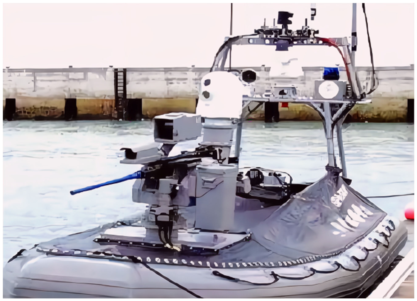
Figure 2.
The waterjet-propelled USV “Owl MK II”.
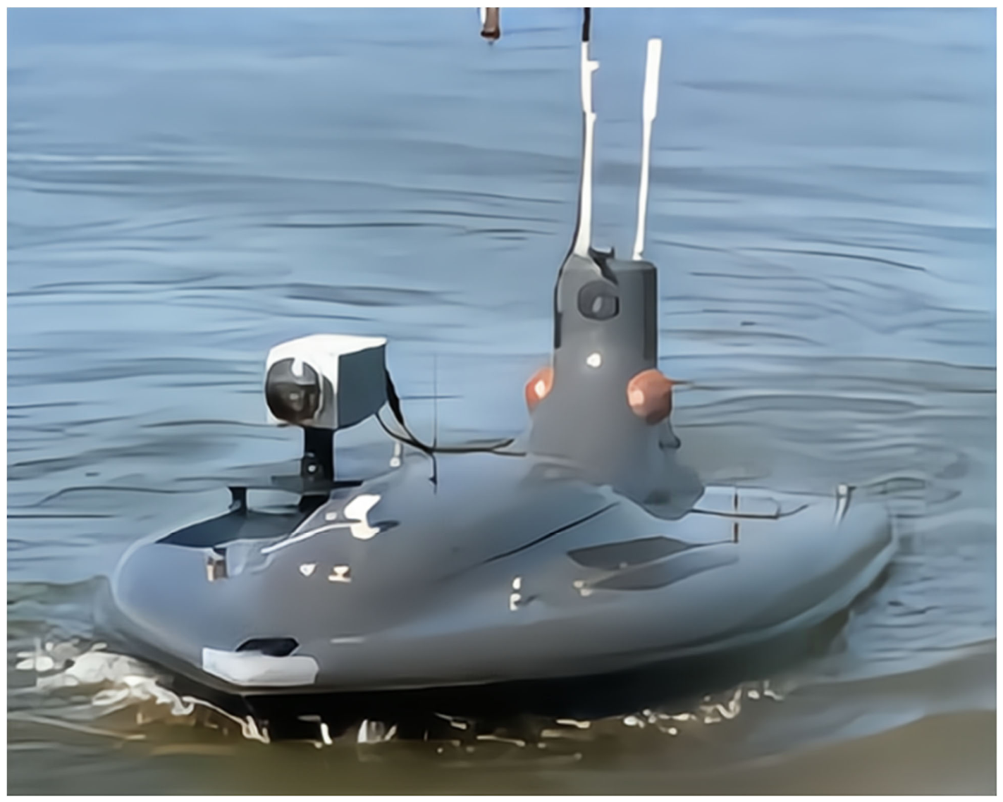
In terms of propulsion, Navtec (United States) developed the waterjet-propelled USV Owl MK II (Figure 2). Waterjet propulsion offers shallow draft, low underwater noise and good cavitation resistance, and is therefore suitable for shallow-water and nearshore operations; it was one of the most common propulsion forms for early USVs [11].
In 2002, QinetiQ (United Kingdom) successfully developed the MIMIR USV. In 2003, Israel developed the Protector USV (Figure 3), a classic design in the history of USV development. Like the Spartan Scout, the Protector is a rigid inflatable boat with a length of 11 m and an operating speed of 0–40 kn. It adopts a modular design and makes extensive use of carbon fiber and lightweight composite materials, reducing hull mass while maintaining low observability. The vehicle also carries a forward-looking infrared sensor, still and video cameras, a laser rangefinder, a search radar and a correlation tracker, together with an unmanned combat system, giving it broad application prospects [4,6].
In 2000, YAMAHA (Japan) designed the Kan-Chan USV, which offers long endurance and plays an important role in monitoring the chemical and physical parameters of the ocean and atmosphere [6]. In 2004, the MIDAS group at the University of Plymouth (United Kingdom) developed Springer, a small and highly concealable USV with excellent applications in pollutant tracking in inland shallow waters, measurement of environmental and channel information, and intelligent patrolling [12,13]. Springer employs simultaneous localization and mapping (SLAM) to compensate for the limited reliability of Global Positioning System (GPS) positioning and to predict the vessel’s next position from the navigation environment. In 2005, Elbit Systems (Israel) produced the Stingary USV, a small, low-observability vehicle with notable advantages in intelligent patrolling, coastal target recognition and electronic warfare [6]. Also in 2005, the Italian catamaran USV Charlie carried out sampling of the sea surface microlayer in Antarctica, collecting data at the air–sea interface and surface microlayer samples, and detecting torpedoes in shallow water [14,15]. In 2006, France delivered the Inspector USV to its navy for testing; it was equipped with a mine neutralizer, sonar and sonar avoidance devices. In 2007, the Silver Marlin medium USV developed by the Israeli Ministry of Defense could be controlled through a shore-based monitoring system and a satellite communication control system, and featured automatic collision avoidance, automatic navigation and over-the-horizon operation [4]. In July 2007, the U.S. Navy released The Navy Unmanned Surface Vehicle Master Plan, which defined four USV classes, namely X Class, Harbor Class, Snorkeler Class and Fleet Class. These four classes increase successively in length and endurance, progress from non-standard to standard modules and from low-level to high-level missions, and also differ in their requirements for launch and recovery modes and hull forms [16]. In 2010, the Venus USV displayed at the Singapore Airshow was capable of carrying mine warfare, electronic warfare, maritime surveillance and precision fire modules [16]. In September 2011, the modular trimaran high-speed reconnaissance USV X-2, developed by the U.S. Navy, could be driven either by wind or by an electric engine and was controlled by radio and GPS, offering agile response and precise maneuvering. In 2013, Israel developed a new Protector USV that is significantly improved in size, performance and stability, with an endurance of more than 12 h. Israel also developed the Silver Marlin medium USV for intelligent coastal patrolling for its Ministry of Defense [8].
In 2016, the United States built “Sea Hunter”, the world’s largest unmanned vessel, an anti-submarine warfare USV. In the civilian sector, UOV Inc. of Virginia (United States) designed a USV with theoretically unlimited endurance for ocean data acquisition and surveying [8]. In March 2017, the Israeli Navy developed and tested a “Sea Knight” USV squadron intended to replace the Protector as its principal USV. On 20 June 2017, Rolls-Royce and Svitzer conducted the world’s first remote-control trial of a commercial vessel in Denmark [17]. In addition, the Z-boat 1800 remotely controlled hydrographic survey boat produced by Oceanscience (United States) integrates GPS, an echosounder, remote-control electronics and an integrated data telemetry system; combined with instruments such as the acoustic Doppler current profiler (ADCP), it provides a new approach to surveying shallow waterways [17]. Russia is developing future USVs with the potential to “transform naval warfare” [18]. In 2016, the country tested the “Explorer” USV, with a maximum speed of 25 kn and an endurance of seven days. The vessel carries a complex gyro-stabilized surveillance and search system, an electro-optical surveillance system, sonar, radio links, electronic countermeasures, a remote vision system and an automatic fire-fighting system. France developed the “Inspector” USV, Germany the “Sea Otter” MK II, and Norway the “Mine Sniper”, while the MAST USV introduced by the British Navy can reach a speed of 50 kn [8,18]. In January 2015, Japan issued a new military and national security space strategy and began to comprehensively improve its intelligence, surveillance and reconnaissance (ISR) capabilities, including in the maritime domain. Japan’s defense technology research headquarters announced joint research on real-time data transmission between unmanned underwater vehicles (UUVs) and USVs, aimed at improving the accuracy, timeliness and effectiveness of intelligence collection [8].
Entering the 2020s, the focus of foreign USV development has shifted from the performance specifications of individual platforms to the establishment of engineering-oriented, large-scale and routine operational capabilities, characterized by three features: larger single platforms, longer endurance and unattended operation. Regarding larger platforms, Exail (France) has developed the transoceanic DriX O-16 with greater displacement and endurance than the 8 m-class DriX H-8, capable of advanced scientific and hydrographic surveys, geophysical and underwater target detection, subsea infrastructure inspection and multi-platform collaborative operations [19]. With respect to unattended operation, the U.S. National Oceanic and Atmospheric Administration (NOAA) and the Center for Coastal and Ocean Mapping (CCOM) at the University of New Hampshire have continuously advanced the operational use of the DriX platform since 2021; in October 2024, they conducted a seabed mapping trial in the Gulf of Maine in which two USVs were simultaneously controlled from a shore-based remote operations center, systematically validating the multi-vehicle collaborative operating mode in terms of operational safety, operator workload, platform endurance and logistical support [20]. In terms of endurance, wind- and solar-powered USVs represented by the Saildrone Explorer, Surveyor and Voyager have formed a product series capable of operating at sea for months without resupply [10,19]. Overall, foreign USVs have moved beyond the principle prototype and technology demonstration stage and entered a new phase of commercial delivery, multi-platform collaboration and routine offshore operations [10,19].
2.2. Development History and Current Status of USVs in China
Although USV research in China started relatively late, it has developed rapidly [2,3,6]. Since 2008, China has systematically carried out USV research, development and application. At present, universities such as Shanghai University and Harbin Engineering University, research institutions including China Aerospace Science and Industry Corporation, China Shipbuilding Industry Corporation and the Chinese Academy of Sciences, and enterprises such as Zhuhai Yunzhou Intelligent Technology Co., Ltd., Wuhan Chuhang Survey Technology Co., Ltd. and Shenzhen Qianhai Xindazhou Technology Co., Ltd. have conducted extensive and in-depth research in this field and achieved remarkable progress, making important contributions to the development of USVs in China [3,6].
In 2008, the “Tianxiang-1” USV of Xinguang became China’s first unmanned marine survey vessel; it served as meteorological emergency equipment during the Qingdao Olympic Sailing Regatta, providing weather support for the event [21]. In May 2009, the Tianjin Institute of Water Conservancy Science developed a wireless remote-controlled topographic survey boat composed of a hull, a drive system, bathymetric equipment and a data transmission system, although it did not achieve integrated automatic navigation and underwater measurement. In November 2011, the remote-controlled survey boat with an automatic navigation system developed jointly by the Yangtze River Waterway Bureau and the Yangtze River Administration of Navigational Affairs achieved remote control over more than 4 km and an endurance of more than 4 h; it was equipped with high-precision GPS, an echosounder and a video system, could travel autonomously along a planned route using a dual gasoline–electric propulsion system, and was well designed, although it was not commercialized [3]. In 2011, the Shenyang Institute of Automation developed a trimaran USV driven by DC motors and composed of a control system, a wireless transmission system and a ground control system, and equipped with a gyro, linear acceleration and angular velocity sensors, a compass and a Hemisphere OEM GPS receiver [22,23]. In 2012, Wuhan Chuhang Survey Technology launched a USV integrating GNSS, a depth sounder, a gyro and a CCD camera. It supports both remote and autonomous control, receives the data acquired by the USV in real time at the shore station, and keeps the deviation from the planned line within 1 m, effectively addressing cross-section and underwater topographic surveying [3].
In November 2013, Zhuhai Yunzhou Intelligent Technology released the world’s first environmental monitoring USV, which can carry out online water pollution and nuclear contamination monitoring. The company holds completely independent intellectual property rights for its USVs, and its products are widely used in water quality monitoring, nuclear radiation monitoring, hydrographic surveying and hydrological research [3]. The Unmanned Surface Vehicle Engineering Research Institute of Shanghai University, the first professional USV research institution in China, has developed the “Jinghai” series of USVs since 2014 (Figure 4) and has delivered “Jinghai 1–4”. Equipped with the BeiDou navigation satellite system, the Jinghai series can perform autonomous positioning, remote dynamic setting of survey lines, autonomous track following and autonomous collision avoidance [2,3]. Organized by the Donghai Navigation Safety Administration of the Ministry of Transport, these USVs have been successfully applied to surveys of the underwater topography, geomorphology and hydrology of the islands and reefs in the South China Sea. “Jinghai 2” participated in China’s 31st Antarctic scientific expedition aboard the icebreaker “Xuelong”, and the Jinghai products under development include environmental monitoring USVs and the “Jinghai” ecological buoy [2]. On 28 June 2017, China formally established its USV research and development technology system, which accelerated the development of USV technology. Harbin Engineering University has carried out in-depth research on USV motion control and simulation, covering motion control, target detection and path planning [23,24]. At the end of 2017, Harbin Engineering University and Shenzhen Hispeed Boat Company jointly designed the “Tianxing-1” USV, with a maximum speed of 50 kn, the fastest USV in the world at that time, which can be used for maritime law enforcement [3]. In February 2018, the HUSTER-68 USV developed by Huazhong University of Science and Technology achieved formation navigation of five USVs and preliminary encirclement, demonstrating the potential of USV swarm tactics [25].
In addition, China State Shipbuilding Corporation has also carried out in-depth exploration in the field of USV research, and has successively designed and built the R1050 and 730 USVs, which feature advanced technologies such as autonomous positioning, remote dynamic setting of survey lines, autonomous track following and autonomous collision avoidance [6]. Shanghai Maritime University successfully developed the aluminum catamaran “Silverfrog”, which is powered by lithium batteries, driven by DC motors and controlled over a wireless local area network, and carries cameras and other instruments; it can be used for harbor surveillance, water sampling and hydrographic surveys [3]. In 2021, the JARI-USV, led by the China Ship Development and Design Center and witnessed by the China Classification Society, completed China’s first autonomous navigation trial at the 100 km scale; in 2024, an improved USV of the same series completed a 1000 km-scale autonomous long-range voyage and intelligent navigation verification in sea state 5 [6,25]. In January 2023, “Zhuhai Yun” (“Zhuhai Cloud”), the world’s first intelligent research mothership for unmanned systems, built under the auspices of the Southern Marine Science and Engineering Guangdong Laboratory (Zhuhai), was officially delivered. The vessel is 88.5 m long and 14.0 m wide, with a design displacement of about 2100 t and a maximum speed of 18 kn. It can carry a variety of aerial, surface and underwater unmanned systems with different observation instruments and perform comprehensive marine survey tasks such as hydrographic surveying, ocean observation, offshore inspection and partial survey sampling, providing a surface support platform for a “mothership–unmanned system” three-dimensional observation network [26].
Through years of development, USV technology has improved significantly and is widely applied in both military and civilian fields, showing a trend toward semi-autonomous and fully autonomous operation. At present, USVs mainly adopt modular designs with diversified functions and can carry a variety of marine survey equipment; their power systems have gradually shifted from conventional gasoline and diesel engines to electric, solar and other clean new-energy systems, which improves endurance and makes them more environmentally friendly [6,18].
In recent years, the development of USVs in China has shown three distinctive features: serialized equipment, clustered operations and routine application. In terms of serialized equipment, China has established a USV product spectrum covering micro, medium and large platforms. Payload configurations have expanded from single-beam echosounders to multibeam echosounders, side-scan sonar, sub-bottom profilers, magnetometers and gravimeters, meeting the requirements of different scenarios such as very shallow water and reef areas, full nearshore coverage and comprehensive deep-sea surveys [3,6].
In terms of clustered operations, the “mothership + USV swarm” mode has moved from demonstration to productive application. Based on consensus theory, distributed formation control methods suitable for multi-USV collaborative ad hoc network surveys have been established in China; these enable the ad hoc network formation to reach state consensus within a finite time and to maintain autonomous collision avoidance, providing a control technology basis for the engineering application of swarm surveying [27]. At the same time, the “mothership–child craft” cross-domain collaborative operating mode, which combines the platform support advantages of large vessels with the maneuverability and flexibility of USVs, has become an important direction for three-dimensional ocean observation [26]. In terms of routine application, USVs have progressively entered the main workflow of marine geological surveying: in 2023, the marine multi-band cloud and fog observation USV developed by the 716th Research Institute of China State Shipbuilding Corporation completed a 110 n mile long-endurance underway observation in the Yellow Sea, with an observation range extendable to 180 n mile from the coast, filling a gap in China’s mobile meteorological and hydrological observation capability in the middle and far seas [28]. Meanwhile, the construction of the standards system has advanced in parallel: after the marine industry standard Technical Requirements for Seafloor Topographic and Geomorphological Survey Using Unmanned Surface Vehicles (HY/T 0353-2023) was issued and implemented, the general standard General Technical Conditions for Marine Survey Unmanned Surface Vehicles (HY/T 0498-2025) was issued in February 2025, providing unified provisions on the product classification, technical requirements, test methods and inspection rules for marine survey USVs and entering into force on 1 May 2025, which marks a new stage in the standardized development of China’s USV marine survey equipment and operations [29,30]. Overall, China’s USV technology and equipment level has progressed from early tracking and imitation to a stage of parallel development characterized by independent innovation, systematic supply and large-scale application, reaching the international advanced level in some specialized directions [6,25,30].
3. Current Status of USV Marine Geological Survey Technology
3.1. Autonomous Control Technology
The autonomous control capability of USVs is the foundation of efficient geological surveying, and has evolved from simple path planning to adaptive decision-making in complex environments [3,6]. Early USVs mostly adopted a semi-autonomous control mode with pre-set routes, and had limited ability to respond to changing sea conditions and sudden obstacles. In recent years, the application of multi-sensor fusion and intelligent obstacle avoidance algorithms has significantly improved the reliability of autonomous control; studies have shown that intelligent collision avoidance maneuvering is one of the key approaches to enhancing USV autonomy [9,12]. Internationally, from September to October 2024, NOAA and the Center for Coastal and Ocean Mapping at the University of New Hampshire jointly carried out the “Dual DriX” project, in which two DriX USVs were simultaneously operated from a shore-based remote operations center to conduct seabed mapping in the Gulf of Maine, verifying the feasibility of the “supervised autonomy” operating mode and of continuous all-weather operation. The two USVs completed more than 2600 n mile of survey lines, and the bathymetric data acquired will be incorporated into NOAA’s hydrographic products (Figure 5 and Figure 6) [20]. In China, during the 2025 competitive benchmarking trial of unmanned intelligent collaborative operations in the pilot zone of Hainan Province, USV swarms of the participating organizations operated in a target area with water depths of 40–70 m off the southern coast of Hainan Island and completed 110 km of survey lines in as little as 13 h; the operating efficiency of the multibeam topographic mapping track was more than 40% higher than that of conventional operations [31]. In addition, for extremely shallow waters, the participating organizations used USVs with a draft of less than 1 m to successfully break through the blind zone of intertidal surveys, filling gaps in fine nearshore geological data [31].
3.2. Geological Exploration Sensor Integration Technology
The level of sensor integration determines the data acquisition capability of USVs in marine geological surveying, and a multi-type, high-precision and modular integration system has now been established [2,3]. In topographic mapping, remarkable progress has been made in the miniaturization and integration of multibeam echosounders. Internationally, medium and large USVs can now generally integrate high-resolution multibeam bathymetric systems and sub-bottom profiling systems simultaneously, acquiring bathymetry, water column, acoustic backscatter and sub-bottom profile data in a single survey, while relying on satellite communication for over-the-horizon remote control and data quality monitoring from shore-based remote operations centers [10,19]. In China, during the 2025 Hainan benchmarking trial, USVs carrying parametric array sonar conducted sub-bottom profiling with a penetration resolution of 5 cm, providing refined data support for the study of nearshore sedimentary structures [31]. In geophysical exploration, single-sensor integration is developing toward multi-parameter simultaneous detection: through the collaborative operation of USVs and AUVs, high-precision near-seafloor mapping can be achieved, and multi-dimensional geological data such as topography, magnetism and gravity can be integrated [1,10]. Furthermore, in the 2025 Hainan benchmarking trial, an underwater vehicle of the participating organizations carrying an imaging hyperspectrometer successfully acquired seafloor mineral spectral data, providing a new approach for the rapid identification of marine mineral resources [31].
3.3. Data Transmission and Processing Technology
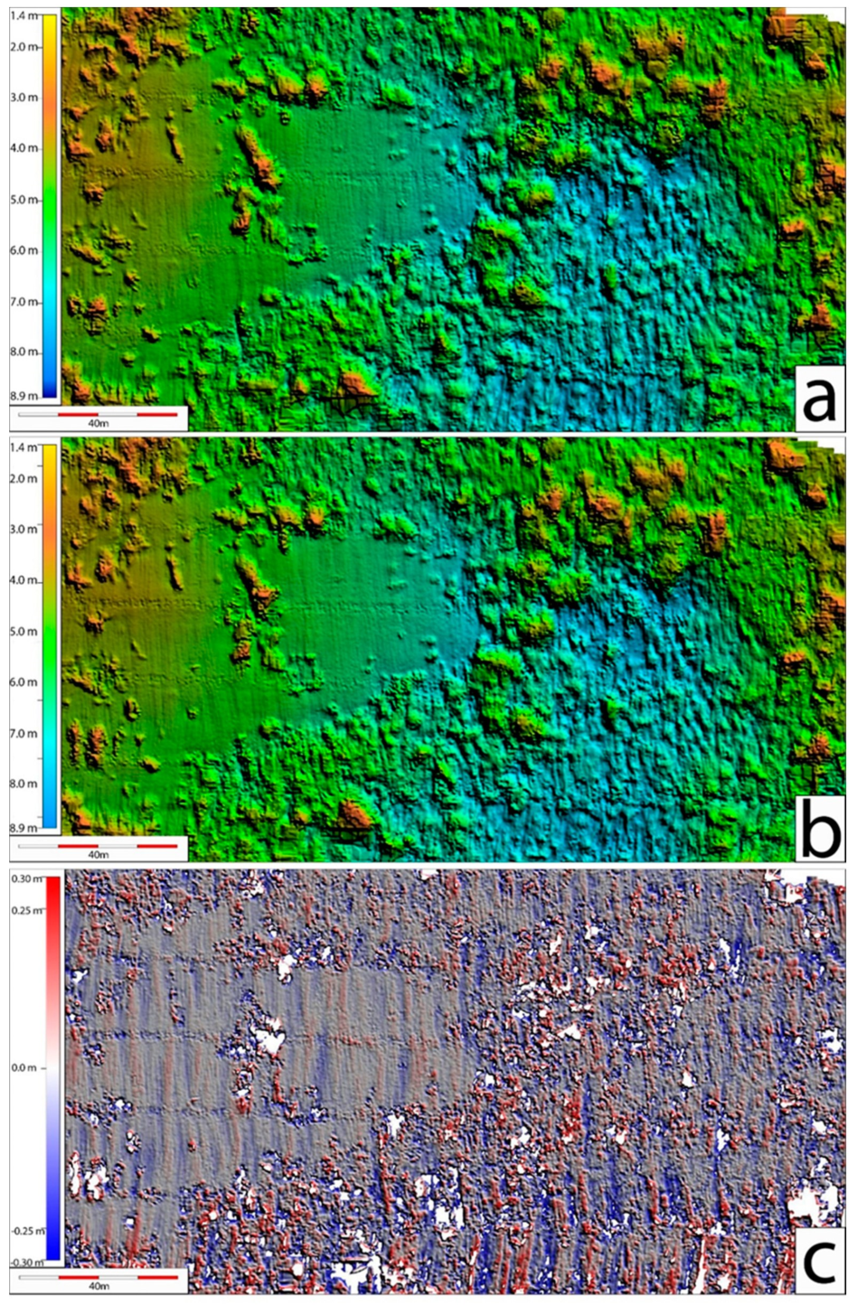
The complexity of the marine environment imposes stringent requirements on the stability and timeliness of USV data transmission, and a multi-network integrated transmission system combining satellite communication, shore-based operations centers and ad hoc networks has been established [3]. In the Hainan trial, the participating organizations solved the problem of real-time interaction among multiple communication networks through standardized port and interface design, ensuring data return for multi-platform collaborative operations [31]. Internationally, long-endurance USVs have achieved near-real-time return of bathymetric data by means of high-bandwidth satellite communication, enabling shore-based hydrographers to monitor data quality remotely and to adjust survey tasks dynamically on the basis of preliminary results [10,19]. USV data processing technology is evolving toward automation and intelligence. Janowski used USV multibeam bathymetric data and the Boruta algorithm to select geomorphometric parameters for building a seabed sediment classification model, and showed that a reduced set of key geomorphometric features can effectively lower the risk of overfitting and improve classification robustness [32]. The adoption of open architectures has lowered the barrier to data processing: OpenSWAP, an autonomous surface vehicle developed by the Institute of Marine Sciences of the Italian National Research Council (ISMAR), adopts a fully open hardware/software architecture and can carry single-beam echosounders, multibeam echosounders, side-scan sonar and sub-bottom profilers; it follows pre-planned routes repeatedly with decimeter-level accuracy and supports user-defined data processing workflows, thereby enabling four-dimensional (three-dimensional space plus time) dynamic geological monitoring in shallow waters [33].
4. Applications of USVs in Marine Geological Surveying
Although remarkable progress has been made in survey vessels and instruments for marine geological surveying, geological surveys in coastal zones, around islands and reefs and in special hazardous waters remain difficult and their accuracy is often compromised, because conventional survey vessels have a deep draft and poor maneuverability and pose potential risks to personnel [2,3]. With their shallow draft, high maneuverability, low observability, high level of intelligence and unmanned operation, USVs have been successfully applied as a new type of survey platform in marine geological surveying [2,6]. Survey-oriented USVs generally have modest speed requirements, typically below 10 kn, but place high demands on payload adaptability, autonomous motion control and endurance. Most such USVs are less than 8 m in length, which is determined by the objectives of marine surveys and the size of their carrier mothership [3]. Usually, the dimensions of a survey mothership are strictly constrained according to the operating area and mission objectives. Despite their large deck working area, such motherships have to carry a great deal of mission equipment, such as large towed systems and gravity corers, so that the actually available deck area is limited and it is difficult to accommodate the storage and launch and recovery of larger USVs. Applications of USVs in marine geological surveying mainly include hydrographic surveying, marine gravity and magnetic measurements, sedimentary environment investigation, underwater target detection, physical oceanographic (meteorological and hydrological) observation, marine biochemical index monitoring and marine biological observation [2,34]. Leading companies in this field include L3 ASV (United Kingdom), Sea Robotics (United States) and Zhuhai Yunzhou Intelligent Technology (China). Saildrone is a leader in special-purpose vessels, focusing on the development of sail-powered USVs with strong endurance that can carry a variety of small sensors, mainly for hydrological and physical oceanographic observation [10,19].
4.1. Seafloor Topographic and Geomorphological Surveying
Seafloor topographic and geomorphological surveying is mainly conducted by acoustic methods, including acoustic tomography, acoustic imaging, high-resolution acoustic multibeam bathymetry, multi-function sub-bottom acoustic profiling and multimedia acoustic communication [34,35,36,37,38]. Compared with land topographic surveying, seafloor topographic and geomorphological surveying is more difficult. Survey vessels are easily affected by water movement and the invisibility of underwater terrain, which leads to lower measurement accuracy, and because of the many influencing factors, the processing of underwater topographic data is more complex. In addition, in some special waters, conventional survey vessels cannot acquire data because of limitations in size and draft, while small boats require personnel on board and therefore involve considerable safety risks. USVs provide an effective solution to many of these problems and have broad application prospects in this field. USVs designed specifically for underwater topographic and geomorphological surveying can play an important role in coastal zone surveys, island and reef surveys, mapping of special sea areas and marine emergency surveying [2].
USVs used for seafloor topographic and geomorphological surveying usually have hulls made of carbon-fiber nanocomposites and generally carry measurement modules including the Global Navigation Satellite System (GNSS), multibeam echosounders, single-beam echosounders, side-scan sonar, synthetic aperture sonar, swath bathymetric systems, sub-bottom profilers and expendable sonar. In addition to seafloor topographic and geomorphological surveying, USVs can also accomplish measurement tasks such as seafloor target detection and sedimentary environment investigation. They mainly operate in an automatic survey mode, carrying high-precision differential positioning equipment on board that keeps the survey deviation within 1 m. By processing bathymetric data and GNSS positioning data, three-dimensional underwater topographic maps and terrain grid maps can be rapidly generated [2,3].
Internationally, USVs were first put into productive underwater topographic and geomorphological surveying as a “force multiplier”: by collecting multibeam and towed side-scan sonar data simultaneously along survey lines adjacent to those of a large survey vessel, they significantly amplified the survey line productivity of the mothership and promoted the large-scale application of USVs in hydrographic surveying [10].
China has also achieved many successful applications in the field of USV underwater topographic surveying in recent years. The M80B USV, jointly developed by Zhuhai Yunzhou Intelligent Technology and the South China Sea Survey Technology Center of the State Oceanic Administration, is an intelligent USV dedicated to marine topographic surveying. Carrying multibeam instruments, it participated in China’s 34th Antarctic scientific expedition aboard “Xuelong” and completed 5 km² of seafloor topographic coverage close to the Antarctic ice front on the western coast of the Ross Sea, acquiring nearshore seafloor topographic data of Antarctica [2]. During the fire and explosion accident at Ruihai Company in Tianjin Port, the S30 USV of Zhuhai Yunzhou Intelligent Technology, carrying a water sampler capable of fully automatic multi-point, fixed-point and quantitative sampling, collected water samples continuously for 24 h in the waters around the port, providing key technical support for environmental emergency response [3]. The South China Sea Branch of the State Oceanic Administration used the ME120 marine survey USV to conduct bathymetric and topographic surveys in the waters of the Xisha Islands and reefs [2].
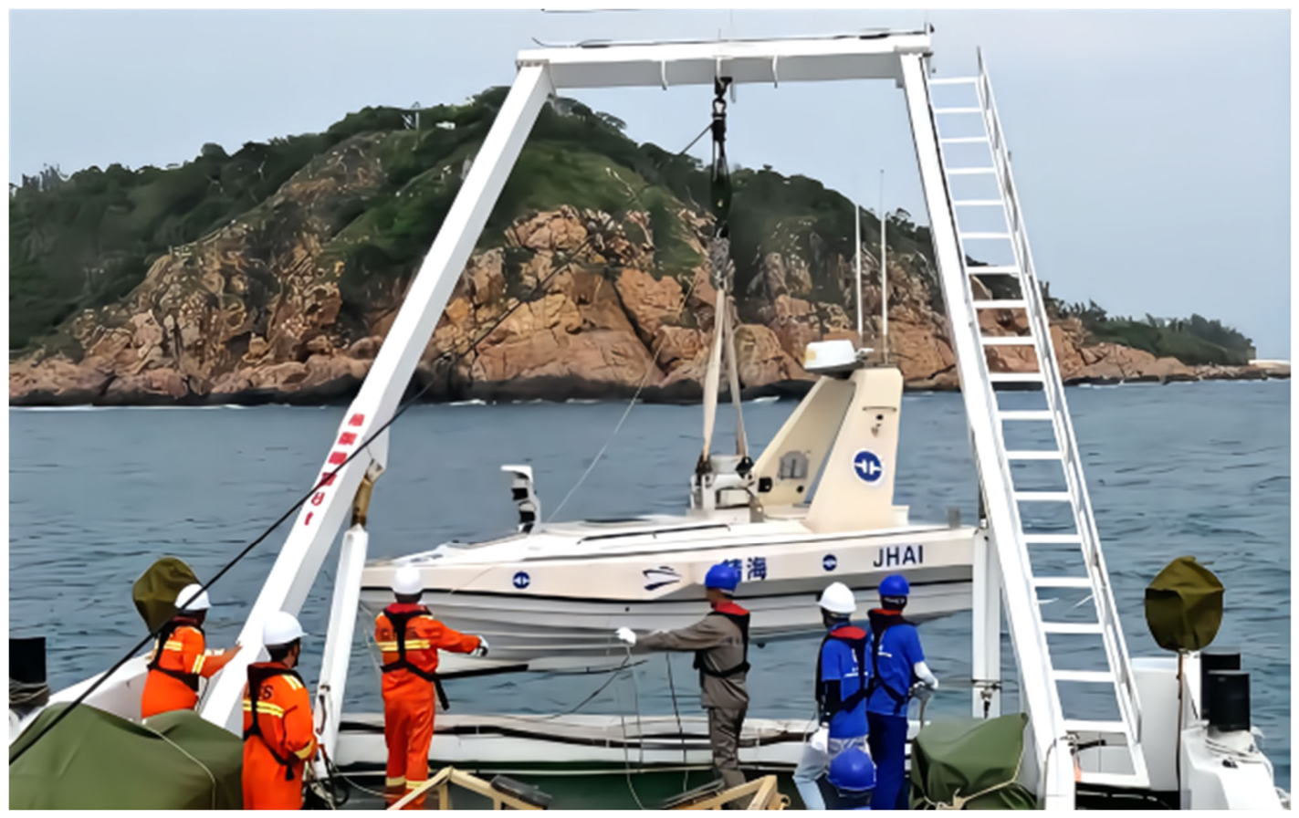
The Jinghai series of USVs developed by Shanghai University is mainly used to survey the underwater topography and geomorphology of waters that the mothership cannot reach. These USVs can be equipped with multibeam bathymetric systems, side-scan sonar, sub-bottom profilers, single-beam echosounders, ADCP, CTD, underwater cameras and other survey equipment. In 2017, the Guangzhou Marine Geological Survey and Shanghai University cooperated to use USVs for the first time to carry out a comprehensive geological survey in the coastal zone of Sanya Bay, Hainan, with multibeam bathymetric systems, side-scan sonar, single-beam echosounders, CTD, ADCP, underwater cameras and other survey equipment. A full-coverage topographic survey of 2 km² was completed around Dongmao Island in Sanya, with about 120 km of survey lines; 145 km of supplementary surveys were conducted in the nearshore waters of Sanya Bay; and 6 km of coastal topographic monitoring profiles were measured, filling gaps in topographic and geomorphological data for the region [2]. In 2018, after the Panamanian tanker “Sanchi” sank in the East China Sea, the “Jinghai 3” USV of Shanghai University, carrying precise positioning equipment and a multibeam echosounder, obtained the accurate position of the wreck, bathymetric data and information on the wreck’s attitude on the seabed, providing strong technical support for the subsequent salvage operation [3].
Figure 7.
USV operation for seafloor topographic and geomorphological surveying.
In recent years, USV topographic surveying technology has achieved breakthroughs in deep-sea and complex waters. In 2022, the Surveyor USV (SD-1200) of Saildrone (United States), in an unmanned expedition to the Aleutian Islands jointly funded by the Bureau of Ocean Energy Management (BOEM) and NOAA, carried Kongsberg EM304 and EM2040 multibeam echosounders and continuously acquired high-quality bathymetric data under severe sea conditions with gusts exceeding 60 kn and significant wave heights over 8 m. Over 52 days, it completed large-scale exploration of previously unmapped waters of the Aleutian Islands—sea conditions under which most manned survey vessels would be unable to operate [10,39].
In shallow-water high-precision surveying, in 2025, the OCEANUS laboratory team at the University of Patras (Greece) used an electric catamaran USV integrating 455/800 kHz dual-frequency side-scan sonar, 83/200 kHz broadband chirp single-beam echosounders and an optical camera to map the semi-submerged ancient city ruins at Grotta, Naxos. Using real-time kinematic (RTK) positioning, the team achieved coordinate accuracy at the 10 mm level and completed high-resolution acoustic imaging and three-dimensional reconstruction of about 90,000 m² of seabed in ultra-shallow water of 0 to −5 m, successfully distinguishing ancient architectural remains from natural bedrock [40]. In China, multi-USV cooperative control technology has been applied in hydrographic surveying, and the maturity of multi-vehicle ad hoc network formation control and autonomous collision avoidance has laid a foundation for large-scale swarm surveying operations [27].
Meanwhile, intelligent data processing technology has developed in parallel. In addition to the machine-learning-based seabed sediment classification method described above [32], low-cost autonomous platforms have also shown good engineering usability: the ABES autonomous USV developed by Sotelo-Torres et al. adopts a rudderless multi-thruster layout and integrates a bathymetric sensor system and a solar power supply system; the reliability of the platform and energy system was validated in long-endurance autonomous bathymetric tasks in lake areas (Figure 8), and two- and three-dimensional water depth results of the survey area were obtained (Figure 9) [41]. These advances jointly drive the transformation of USV seafloor topographic and geomorphological surveying from “data acquisition” toward integrated “data–information–knowledge” processing.
4.2. Sub-Seafloor Geophysical Exploration
As a multidisciplinary technique, marine geophysical exploration commonly includes marine seismic exploration, marine gravity measurement, marine magnetic measurement, marine electromagnetic detection and seafloor heat flow measurement [1,35]. Gravity and magnetic measurements are the most direct means of obtaining sub-seafloor geophysical information and are the basis of all sub-seafloor geophysical exploration. Marine gravity data play a vital role in resource exploration and geological structure studies, and are also in great demand in aerospace, military and geodynamics research. Marine magnetic surveys hold an irreplaceable position in seafloor mineral exploration, and are also effective in detecting buried and abandoned ferromagnetic objects on the seafloor, such as bombs, mines, sunken ships and pipelines. In addition, since the submerged navigation and concealment of reconnaissance submarines and the laying of mines are closely related to the geomagnetic field, the value of marine geomagnetic exploration in the military field is becoming increasingly prominent [1]. Marine seismic exploration is a technique for studying seabed geological structures and conducting seabed resource exploration on the basis of the propagation of seismic waves in seabed strata. At present, it is the most widely used and most effective technique in seabed geophysical exploration. However, limited by the size of its equipment and the need for manual operation during measurement, this technique cannot yet be applied on USVs. Therefore, the main application of sub-seafloor geophysical exploration on USV platforms is currently gravity and magnetic measurement [2].
Similar to their application in seafloor topographic and geomorphological surveying, marine gravity and magnetic measurements using USVs require the modification and integration of gravity and magnetic measurement instrument systems on board, and rely on functions such as remote control, GNSS automatic navigation, autonomous navigation and automatic obstacle avoidance to realize beyond-line-of-sight operations [2,3]. During operations, the nautical chart of the working area must be prepared at the base station, coordinates entered to plan the survey lines, and the task uploaded to the USV, which is then controlled to conduct marine gravity and magnetic measurements in the designated sea area. However, unlike seafloor topographic and geomorphological surveying, marine gravity and magnetic measurement imposes higher requirements on the stability of the survey platform and on measurement accuracy. In this case, the small size and flexibility of USVs become a disadvantage; therefore, overcoming the large-amplitude motion of USVs during marine surveys has become an urgent problem to be solved in USV gravity and magnetic measurement [42]. Because of this technical difficulty, although there is a large demand for gravity and magnetic data in marine geophysical surveys, USV gravity and magnetic measurement has not yet been widely applied and is still largely at the experimental stage [2,42]. At present, the China Aero Geophysical Survey and Remote Sensing Center for Natural Resources and the Qingdao Institute of Marine Geology have carried out in-depth research in this respect. The USV gravity and magnetic measurement system developed by the China Aero Geophysical Survey and Remote Sensing Center for Natural Resources has been successfully integrated and modified on several USV models and has completed regional USV marine gravity and magnetic measurements with good results, awaiting further promotion [42].
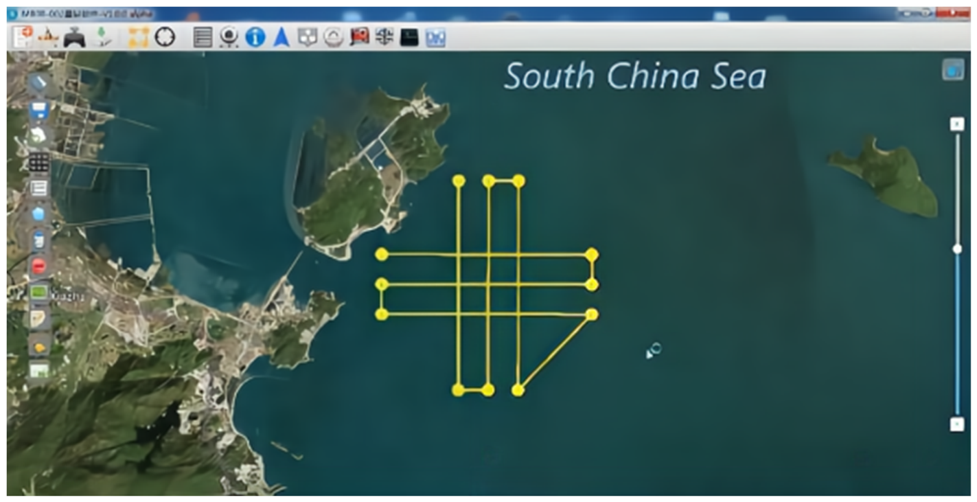
In 2018, the Qingdao Institute of Marine Geology, in cooperation with Zhuhai Yunzhou, integrated the towed Marine Magnetometer Seaspy 2 and the SAG-2M strapdown gravimeter onto a USV and completed 70 km of survey lines in the sea area off Qiao Island, Zhuhai. According to the pre-determined deployment length of the towed body, the magnetometer probe was maintained at a towing distance of 20 m throughout the survey, effectively avoiding interference from the magnetic field of the USV platform. During data acquisition, the instruments operated stably and normally with smooth signals, and the fluctuation of the magnetic data was generally less than 0.5 nT. The gravity anomalies were free-air anomalies after normal gravity correction and the Eötvös correction only, without drift, height or tidal corrections, and the internal consistency accuracy of the gravimeter was controlled to within 2 mGal on average [2,42].
Figure 10.
The USV gravity and magnetic measurement system and survey lines integrated by the Qingdao Institute of Marine Geology.
Figure 10.
The USV gravity and magnetic measurement system and survey lines integrated by the Qingdao Institute of Marine Geology.
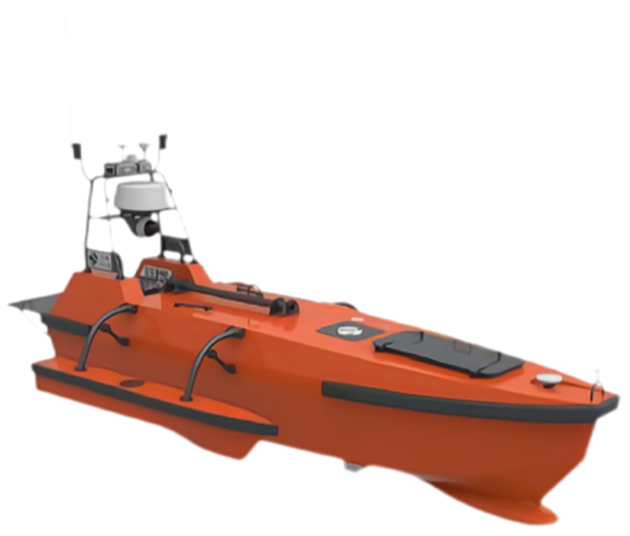
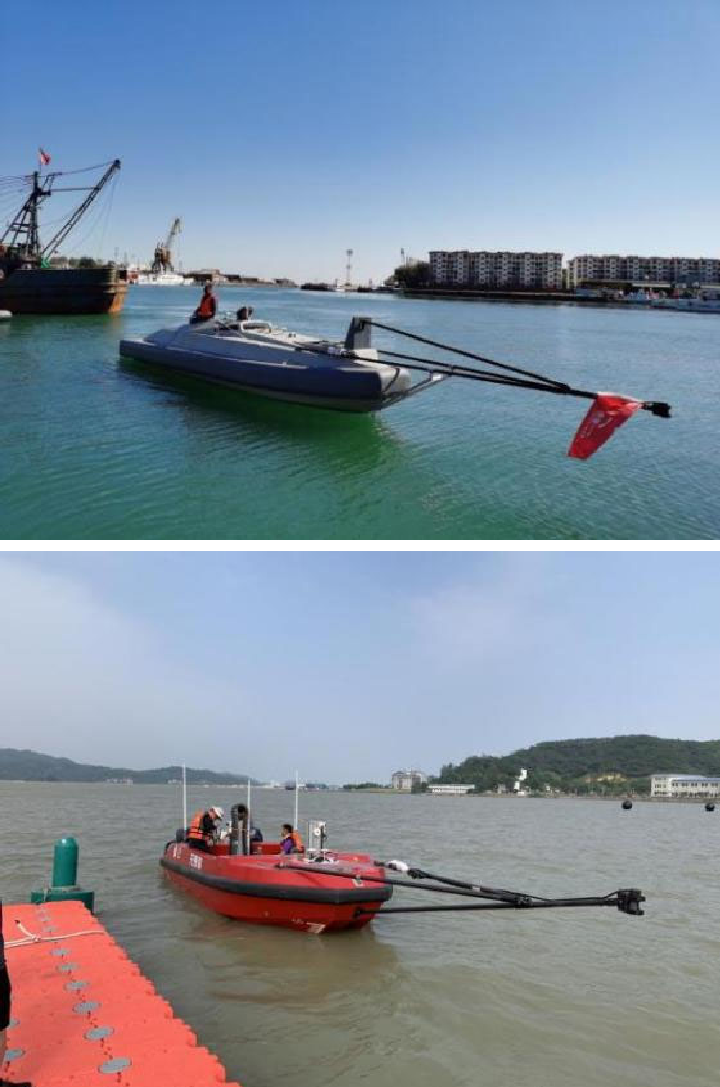
In 2019, the China Aero Geophysical Survey and Remote Sensing Center for Natural Resources, in cooperation with Zhuhai Yunzhou, successfully integrated its independently developed USV gravity and magnetic measurement system onto an L30 USV and completed more than 72 km of survey lines in the sea area off Qiao Island, Zhuhai. The magnetometer was a self-developed USV magnetometer installed in a boom-mounted configuration. Based on the hull magnetism measured before the sea trial, the boom length from the hull was set to 3.5 m, which effectively avoids hull magnetic interference. The gravimeter was the SAG-2M strapdown gravimeter developed by the Beijing Institute of Aerospace Control Devices. The internal consistency accuracy of gravity measurement reached 2 mGal, the fourth-order difference of magnetic measurement was less than 80 pT, and the crossover accuracy was within 5 nT. In 2020, the system was used to complete a USV magnetic areal survey of 100 km² in the sea area off Qiao Island, Zhuhai. In 2021, the Center, in cooperation with the 707th Research Institute of China State Shipbuilding Corporation, successfully integrated a purposefully upgraded USV gravity and magnetic measurement system onto an R1050 USV and completed a USV gravity and magnetic areal survey of more than 160 km² in the sea area near Shanhaiguan, Qinhuangdao; after the improvement, the internal consistency accuracy of gravity measurement reached 1 mGal [2].
Figure 11.
Gravity and magnetic measurement platforms based on the R1050 (top) and L30 (bottom) USVs.
Figure 11.
Gravity and magnetic measurement platforms based on the R1050 (top) and L30 (bottom) USVs.
The team from the School of Smart Marine Science and Technology of Fujian University of Technology and the Key Laboratory of Marine Environmental Detection Technology and Application of the Ministry of Natural Resources has systematically studied the processing of sea–air gravity measurement data and proposed an error separation and compensation scheme that combines adaptive adjustment of the filter scale with a zero-correlation criterion constraint. This scheme reduces the crossover root-mean-square error of shipborne gravity measurements from more than 10.0 mGal to less than 3.0 mGal and improves the data resolution by more than 17%, providing methodological support for the precise processing of USV surface gravity measurement data [43]. In the “horse-race” evaluation of unmanned intelligent collaborative operations in the pilot zone, jointly organized by the Hainan Institute of Mineral Resources Exploration and Hainan Kaipu Digital Technology Co., Ltd. in 2025, China achieved for the first time the engineering application of a miniaturized atomic gravimeter on an unmanned platform and successfully completed high-precision gravity observations in a target area with water depths of 40–70 m, verifying the practical value of quantum sensing technology in marine gravity exploration [31]. In terms of equipment, Zhou et al. used a self-developed shipborne quantum gravimeter to carry out continuous marine absolute gravity measurements over 71 days; the internal consistency accuracy along repeated survey lines reached 0.42 mGal and the external accuracy compared with a co-located relative gravimeter reached 0.39 mGal. The differences relative to the same gravity datum before departure and after return were 0.06 mGal and 0.21 mGal, respectively, and the crossover discrepancy was 0.76 mGal, indicating the good long-term stability of the shipborne quantum gravimeter and providing support for establishing marine absolute gravity datums and obtaining large-scale marine gravity maps [44]. Meanwhile, the China Aero Geophysical Survey and Remote Sensing Center for Natural Resources has continued to conduct offshore demonstrations using its independently developed USV gravity and magnetic measurement system: in 2021 it completed 478.5 km of USV gravity and magnetic areal surveys in the sea area near Shanhaiguan, Qinhuangdao, and in 2022 it moved to the sea area near Huangdao District, Qingdao, completing 332.8 km; the internal consistency accuracy of gravity along offshore repeated lines reached the level of 1 mGal in both years [45].
In magnetic measurement, during the unmanned intelligent collaborative operations trial conducted in the southern waters of Hainan in 2025, a wave glider of the participating organizations carrying magnetic sensors operated continuously for 94 h in sea state 3–4 and achieved 100% completeness of magnetic data, establishing an economical and efficient new model for large-area marine magnetic exploration [31]. In terms of equipment and error compensation, small USVs often carry magnetometers in a towed configuration, and the attitude stability of the towed body directly affects data quality [46]; the towed marine geomagnetic vector measurement system developed by Luo et al. was verified by sea trials to have an internal consistency accuracy along repeated lines better than 6.7 nT and a crossover internal consistency accuracy better than 6 nT, providing an equipment basis for high-precision geomagnetic vector measurement on USV platforms [47]. In industrial applications, in May 2025, China’s independently developed “Haiwei” system, an intelligent monitoring equipment for deep-water submarine pipeline laying, completed its sea trial. The system consists of a USV, an autonomous and remotely operated vehicle (ARV), a repeater and optical communication equipment, and is designed for operating water depths of up to 1500 m. An independently developed 18 m-class USV was applied for the first time as the core surface platform (surface base station), supplying power and control signals to the underwater repeater and optical communication equipment and dynamically maintaining the “ARV–repeater–USV–mothership” communication link, which increased the accuracy of intelligent identification of pipeline touchdown points to over 95% [48]. In USV magnetic measurement, the digital helium optically pumped magnetometer developed by the Center adopts a carbon-fiber boom-mounted probe; combined with digital magnetic compensation technology, the improvement ratio of the total field after compensation reaches 10.293. The total magnetic measurement accuracy of the areal surveys in the sea area off Shanhaiguan, Qinhuangdao in 2021 and off Huangdao, Qingdao in 2022 was 3.78 nT and 3.66 nT, respectively, meeting the accuracy requirements of the current marine magnetic survey specifications [45].
The multi-method integrated exploration system has been further improved. The 2025 Hainan trial verified for the first time the engineering capability of the “manned mothership + unmanned swarm” collaborative operation system, with the daily workload of USVs reaching 1.5 times that of conventional vessels; the evaluation was conducted simultaneously in six tracks, namely multibeam bathymetry, sub-bottom profiling, gravity, magnetic, hyperspectral and seafloor geological sampling, comprehensively verifying the technical feasibility of various intelligent equipment such as USVs, semi-submersible vehicles, wave gliders and ROVs in marine mineral exploration [31]. Internationally, Mayer pointed out that replacing large manned research vessels with USVs for seabed mapping can significantly reduce costs and improve efficiency, and has given rise to a new “mothership–USV–AUV” collaborative operating mode, making unmanned platforms a “force multiplier” for manned survey vessels [10].
5. Recent Advances and Technological Trends in USV Marine Geological Surveying
5.1. Breakthroughs in Cross-Domain Collaborative Operation Technology
Cross-domain collaboration is currently the core development trend of USV marine geological surveying, building a three-dimensional survey network by integrating aerial (UAV), surface (USV), underwater (AUV/ROV) and shore-based platforms. The first unmanned intelligent collaborative “horse-race” evaluation in Hainan in 2025 verified the engineering capability of the “manned mothership + unmanned swarm” system; through collaborative control, multiple types of equipment such as USVs, semi-submersible vehicles, wave gliders and ROVs achieved the simultaneous execution of six types of tasks, including multibeam surveying, geological sampling and hyperspectral detection, with the daily workload of USVs reaching 1.5 times that of conventional vessels [31].
Collaborative control technology is evolving from simple task allocation to intelligent collaborative decision-making. The cross-domain swarm theory for marine unmanned systems proposed by Yan and Guan achieves efficient collaboration among heterogeneous platforms through three core technologies, namely task planning, networking transmission and collaborative control, providing methodological support for collaborative operations in complex marine environments [49]. Internationally, Mayer pointed out that unmanned surface systems are driving global ocean exploration into a new stage, and that “mothership–USV–AUV” collaboration has become a typical mode for improving survey efficiency and expanding operational coverage, giving rise to remote deployment and recovery solutions for the deep sea [10]. In addition, the construction of an integrated “space–air–ground–sea” relay transmission network has resolved the communication bottleneck in cross-domain collaboration and provided a stable guarantee of information exchange for wide-area marine geological surveying [49].
5.2. Innovation and Upgrading of Core Technologies and Equipment
Innovations in power systems have significantly improved the endurance of USV operations. Long-endurance USVs with sail–diesel hybrid power supplemented by solar energy can operate continuously for several weeks without port replenishment, and their greenhouse gas emissions are far lower than those of conventional survey vessels [10,19]; the wave gliders of the participating organizations, driven by solar and wave energy, operated continuously for 94 h in sea state 3–4 during the Hainan trial, reducing energy costs by more than 70% compared with conventional operations [31]. These technological innovations are promoting the shift of USVs from short-term task execution to long-term routine surveys.
Sensor and platform technologies are simultaneously evolving toward high precision, low cost and openness. In China, the 2025 Hainan trial achieved for the first time the engineering application of a miniaturized atomic gravimeter on an unmanned platform, providing a new means for high-precision gravity exploration in nearshore waters and around islands and reefs [31]. Internationally, low-cost open-source payloads have significantly lowered the equipment barrier: OpenSWAP, developed by ISMAR (Italy), adopts open-source hardware platforms such as Arduino and Raspberry Pi, has a maximum payload capacity of more than 40 kg, can flexibly integrate side-scan sonar, multibeam echosounders, multi-parameter probes and sub-bottom profilers, and supports user modification and expansion (Figure 12) [33]. At the same time, the autonomous navigation accuracy of USVs continues to improve: OpenSWAP can sail stably along pre-planned routes with decimeter-level accuracy, repeatedly acquiring bathymetric data with a multibeam echosounder and comparing data from different epochs, making repeated (4D) dynamic geological monitoring in shallow waters a routine practice (Figure 13) [33].
5.3. Expansion of Application Areas and Standardization
The application scenarios of USVs in marine geological surveying are expanding from conventional topographic mapping to diversified fields. In underwater archaeology, Ravnås et al. used an autonomous surface vehicle carrying a single-channel chirp sub-bottom profiling system to acquire high-resolution three-dimensional data of a medieval shipwreck site at a water depth of about 1 m in the intertidal zone with a line spacing of 0.25 m, accurately outlining the hull and determining its dimensions and maximum burial depth [50]; Merkouris et al. used a USV to carry out high-resolution combined acoustic and optical mapping of semi-submerged ancient city ruins in ultra-shallow water of 0 to −5 m, providing an example of non-invasive investigation of underwater cultural heritage [40]. In China, during the 2025 Hainan trial, USVs were applied to marine strategic mineral exploration projects, improving the accuracy and efficiency of mineral resource exploration through multi-parameter collaborative detection with multibeam, sub-bottom profiling, gravity, magnetic, hyperspectral and geological sampling [31].
Standardization has become an important support for the development of the industry. The marine industry standard Technical Requirements for Seafloor Topographic and Geomorphological Survey Using Unmanned Surface Vehicles (HY/T 0353-2023), implemented from September 2023, for the first time systematically stipulates the technical design, field implementation, data processing and product compilation of seafloor topographic and geomorphological surveys using USVs, filling a gap in domestic standards in this field [29]. In the Hainan trial, the participating organizations took an in-depth part in drafting the technical standard draft Specification for Unmanned Swarm Collaborative Operation Process and established an equipment selection database, clarifying the applicable scenarios and operational standards of different equipment [31]. Internationally, global initiatives represented by Seabed 2030 are promoting the open sharing and format unification of USV survey data, facilitating the fusion and application of multi-source data [10]. These advances indicate that USV marine geological surveying is moving from technology development toward standardization and industrialization.
6. Challenges and Future Directions
6.1. Existing Technical Challenges
Despite the remarkable progress achieved in USV marine geological survey technology, many bottlenecks remain. In terms of adaptability to complex environments, current USVs have limited operating capability in sea state 5 and above and in strong current areas; the Hainan trial revealed that light equipment is constrained when seabed surge is too strong [31], and the impact of extreme environments such as severe cold and high salt spray on equipment reliability still needs to be overcome [3]. In terms of autonomous decision-making, intelligent decision-making algorithms for handling conflicts among multiple tasks and for emergency response to sudden geological hazards are not yet mature, and the accuracy of target recognition under complex geological conditions needs to be improved [49].
Data quality control and communication support are also key challenges. Acoustic interference in shallow water reduces the signal-to-noise ratio of seismic data, while limited satellite communication bandwidth in deep water affects the real-time transmission of large data volumes; the problem of error accumulation in multi-source data fusion has not been fully resolved, and unified standards for data accuracy verification are lacking [29,33]. In addition, the domestic production rate of core components is insufficient, and the engineering application of key equipment such as high-precision multibeam sonar and quantum gravimeters is still in its infancy, constraining the development of technological independence [3,44].
6.2. Future Development Directions
(1) Improving the level of intelligence and autonomy. Future USVs will evolve toward fully autonomous decision-making, building a “perception–decision–execution” closed-loop system by integrating deep learning, digital twins and other technologies. Based on digital twin models of the marine environment, USVs will be able to dynamically optimize and precisely execute survey tasks; artificial-intelligence-driven intelligent diagnostic algorithms will monitor equipment status in real time, improving fault prediction and self-recovery capabilities [10,49].
(2) Improving the cross-domain collaborative system. Building an integrated “air–space–water–seafloor” survey network is the core development direction. Through the integration of new communication technologies and edge computing, real-time sharing and collaborative processing of cross-platform data will be realized; collaborative control protocols for heterogeneous platforms will be developed to improve the linkage efficiency of USVs with UAVs, AUVs and seafloor observation stations [49]. Emphasis should be placed on breaking through the cross-domain communication bottleneck in the deep sea and establishing a broader marine unmanned survey communication network, so as to support large-scale, high-precision marine geological surveys [10,20].
(3) Independent development and standardization of core technologies. The domestic development of core components such as high-precision sensors and autonomous control systems should be accelerated, and the technical and engineering barriers of key equipment such as multibeam echosounders and miniaturized gravimeters should be overcome [19,44]. The industry standard system should be improved, with equipment technical specifications, data quality control standards and operational process guidelines for USV marine geological surveys formulated to promote data sharing and the transformation of results [29,31]. A three-in-one verification system of “numerical simulation—tank testing—sea trial” should be established to accelerate technological iteration and engineering application.
(4) Deepening the expansion of application scenarios. In resource exploration, precise detection technology for deep-sea mineral resources should be developed to achieve quantitative assessment of polymetallic nodules, cobalt-rich crusts and other resources [31]. In geological hazard prevention and control, a real-time monitoring and early warning system for marine geological hazards based on USVs should be established to improve the prediction capability for tsunamis, submarine landslides and other hazards [33]. Survey applications in extreme environments such as polar regions and hadal zones should be expanded to provide basic data for global climate change research [10,39]. At the same time, military–civilian integration should be promoted to achieve the two-way transformation and sharing of technological achievements.
7. Conclusions
USVs have become revolutionary equipment in the field of marine geological surveying. Their technical systems have achieved remarkable breakthroughs in autonomous control, sensor integration and data processing, and have shown great application value in scenarios such as offshore surveys, deep-sea exploration and special environmental monitoring [2,10]. In recent years, the development of cross-domain collaborative technology and the advancement of standardization have further expanded the application boundaries of USVs, driving marine geological surveying toward greater efficiency, precision and intelligence [29,31]. Facing challenges such as insufficient adaptability to complex environments and a low degree of independence in core technologies, future efforts should focus on intelligent upgrading, improvement of cross-domain collaborative systems, breakthroughs in core technologies and expansion of application scenarios, so as to achieve leapfrog development of USV marine geological survey technology [44,49]. As the technology continues to mature, USVs will play an even more critical role in safeguarding national maritime rights and interests, ensuring marine resource security and addressing global climate change, providing solid technical support for the building of a strong maritime nation.
Author Contributions
Conceptualization, S.L. and H.C.; methodology, S.L.; software, S.L. and Q.G.; validation, S.L., S.G. and R.D.; formal analysis, S.L.; investigation, S.L., B.L. and C.W.; resources, H.C.; data curation, S.L. and Q.G.; writing—original draft preparation, S.L.; writing—review and editing, H.C., S.G. and R.D.; visualization, S.L. and Q.G.; supervision, H.C.; project administration, C.W.; funding acquisition, C.W. All authors have read and agreed to the published version of the manuscript.
Funding
This research was funded by the Geological Survey Project (Grant No. DD2026033031).
Institutional Review Board Statement
Not applicable.
Informed Consent Statement
Not applicable.
Data Availability Statement
The data presented in this review are derived from the published sources cited in the reference list. No new datasets were generated.
Acknowledgments
The authors thank the China Aero Geophysical Survey and Remote Sensing Center for Natural Resources for its institutional support. During the preparation of this manuscript, the authors used generative artificial intelligence tools solely to improve the English language, grammar and readability. The scientific content, analysis and conclusions were produced entirely by the authors, who reviewed and verified all AI-assisted text and take full responsibility for the accuracy and integrity of the manuscript.
Conflicts of Interest
The authors declare no conflicts of interest.
References
- Jin, X.L. Development of Marine Geophysical Technology. J. East China Inst. Technol. (In Chinese) 2004, 27, 6–13. [Google Scholar]
- Fang, Z.H.; Chu, H.X.; Feng, J.; et al. Application and Prospect of Unmanned Surface Vehicles in Marine Geological Survey. Mar. Geol. Front. (In Chinese) 2020, 36, 72–77. [Google Scholar] [CrossRef]
- Dong, C.; Liu, W.; Li, X.; et al. Domestic Application Progress and Prospect of Unmanned Surface Vehicles in Marine Survey. Navig. Control (In Chinese) 2019, 18, 1–9. [Google Scholar]
- Liu, C.G.; Chu, X.M.; Wu, Q.; et al. Development Status and Prospect of USVs. Shipbuild. China (In Chinese) 2014, 55, 194–205. [Google Scholar]
- Chen, Y.B. Review of the Development Status and Key Technologies of Unmanned Surface Vehicles. Sci. Technol. Innov. (In Chinese) 2019, 2, 60–61. [Google Scholar]
- Pu, J.J.; Liu, H.; Jiang, Y.H.; et al. Review of the Status and Development Trend of Unmanned Surface Vehicles. Mar. Inf. Technol. Appl. (In Chinese) 2020, 35, 6–11. [Google Scholar]
- Bertram, V. Unmanned Surface Vehicles—A Survey; Skibsteknisk Selskab: Copenhagen, Denmark, 2008. [Google Scholar]
- Wang, S.; Zhang, J.Q.; Yang, S.H. Research on the Development Status and Typical Operational Applications of Unmanned Surface Vehicles in China and Abroad. Fire Control Command Control (In Chinese) 2019, 44, 11–15. [Google Scholar]
- Larson, J.; Bruch, M.; Halterman, R.; et al. Advances in Autonomous Obstacle Avoidance for Unmanned Surface Vehicles; Space and Naval Warfare Systems Center: San Diego, CA, USA, 2007. [Google Scholar]
- Mayer, L. Uncrewed Surface Systems Facilitating a New Era of Global Ocean Exploration. Int. Hydrogr. Rev. 2023, 29, 42–55. [Google Scholar] [CrossRef]
- Kong, Q.F.; Wu, J.M.; Jia, Y.; et al. Research on Waterjet Propulsion Technology for Ships. Ship Sci. Technol. (In Chinese) 2004, 3, 28–30. [Google Scholar]
- Campbell, S.; Naeem, W.; Irwin, G.W. A Review on Improving the Autonomy of Unmanned Surface Vehicles through Intelligent Collision Avoidance Manoeuvres. Annu. Rev. Control 2012, 36, 267–283. [Google Scholar] [CrossRef]
- Yan, R.J.; Pang, S.; Sun, H.B.; et al. Development and Missions of Unmanned Surface Vehicle. J. Mar. Sci. Appl. 2010, 9, 451–457. [Google Scholar] [CrossRef]
- Caccia, M.; Bibuli, M.; Bono, R.; et al. Charlie, a Test Bed for USV Research. In Proceedings of the 8th IFAC International Conference on Manoeuvring and Control of Marine Craft, Guarujá, Brazil, 2009; pp. 1–6. [Google Scholar]
- Caccia, M. Basic Navigation, Guidance and Control of an Unmanned Surface Vehicle. Auton. Robot. 2008, 25, 349–365. [Google Scholar] [CrossRef]
- Wan, J.X. Development Status and Trends of Foreign Military Unmanned Surface Vehicles. Natl. Def. Sci. Technol. (In Chinese) 2014, 5, 91–96. [Google Scholar]
- Zhang, S.K.; Liu, Z.J.; Zhang, X.K.; et al. Development and Prospect of Unmanned Surface Vehicles. World Shipp. (In Chinese) 2015, 38, 29–36. [Google Scholar]
- Zhu, B.X.; Yu, F.S.; Liang, W. Development Trends of Unmanned Surface Vehicles in China and Abroad. Ship Eng. (In Chinese) 2020, 42, 20–23. [Google Scholar]
- de Andrade, E.M.; Sales, J.S., Jr.; Fernandes, A.C. Operative Unmanned Surface Vessels (USVs): A Review of Market-Ready Solutions. Automation 2025, 6, 17. [Google Scholar] [CrossRef]
- Schmidt, V.; Bergeron, J. User Interface and Watchstation Improvements Required for Multi-Vehicle USV Operations. In Center for Coastal and Ocean Mapping; University of New Hampshire: Durham, NH, USA, 2025. [Google Scholar]
- Liu, W.Y. The Xinguang Unmanned Surface Vehicle Contributing to the Scientific and Technological Olympics. Aerosp. Ind. Manag. (In Chinese) 2008, 8, 46–47. [Google Scholar]
- Liao, Y.L.; Pang, Y.J.; Zhuang, J.Y. Research on the Embedded Basic Motion Control System of Unmanned Surface Vehicles. Comput. Sci. (In Chinese) 2010, 37, 214–217. [Google Scholar]
- Liao, Y.L. Research on Nonlinear Motion Control Methods for Unmanned Surface Vehicles. Ph.D. Thesis, (In Chinese) Harbin Engineering University, Harbin, China, 2012. [Google Scholar]
- Lu, Y.S. Research on Path Planning Algorithms for Unmanned Surface Vehicles. Master’s Thesis, (In Chinese) Harbin Engineering University, Harbin, China, 2010. [Google Scholar]
- Li, W.; Li, T.W.; Zhang, S.Y.; et al. Development and Prospect of Unmanned Surface Vehicle Technology. Ship Electron. Eng. (In Chinese) 2021, 41, 1–6. [Google Scholar]
- Li, C.; Lou, J.K.; Zhang, M.Y. Review of the Application and Collaboration of Intelligent Unmanned Surface Vehicle Technology. Ship Eng. (In Chinese) 2026, 48, Z39–Z58. [Google Scholar] [CrossRef]
- Wang, L.H. Implementation of Cooperative Control of Unmanned Surface Vehicle Swarms in Hydrographic Surveying. Bull. Surv. Mapp. (In Chinese) 2022, 5, 145–149. [Google Scholar]
- Meteorological Observation Center of the China Meteorological Administration. Development and Demonstration Application of Marine Multi-Band Cloud and Fog Observation Equipment; (In Chinese). Meteorological Observation Center of CMA: Beijing, China, 2023. [Google Scholar]
- Ministry of Natural Resources of the People’s Republic of China. Technical Requirements for Seafloor Topographic and Geomorphological Survey Using Unmanned Surface Vehicles: HY/T 0353-2023; (In Chinese). Standards Press of China: Beijing, China, 2023. [Google Scholar]
- Ministry of Natural Resources of the People’s Republic of China. General Technical Conditions for Marine Survey Unmanned Surface Vehicles: HY/T 0498-2025; (In Chinese). Standards Press of China: Beijing, China, 2025. [Google Scholar]
- Lin, H. Racing for Higher Efficiency of Unmanned Equipment Operations. China Nat. Resour. News (In Chinese) 2025. [Google Scholar]
- Janowski, L. Advancing Seabed Bedform Mapping in the Kuźnica Deep: Leveraging Multibeam Echosounders and Machine Learning for Enhanced Underwater Landscape Analysis. Remote Sens. 2025, 17, 373. [Google Scholar] [CrossRef]
- Stanghellini, G.; Del Bianco, F.; Gasperini, L. OpenSWAP, an Open Architecture, Low Cost Class of Autonomous Surface Vehicles for Geophysical Surveys in the Shallow Water Environment. Remote Sens. 2020, 12, 2575. [Google Scholar] [CrossRef]
- Jin, X.L. Development of Marine Geophysical Research and Seafloor Detection Acoustic Technology. Prog. Geophys. (In Chinese) 2007, 22, 1243–1249. [Google Scholar]
- Zhu, X.K.; Jin, X.L.; Tao, C.H.; et al. Discussion on the Development of Marine Detection Technology and Equipment. Robot (In Chinese) 2013, 35, 376–384. [Google Scholar] [CrossRef]
- Li, A.L.; Cao, L.H.; Li, G.X.; et al. Application of Side-Scan Sonar in Seabed Detection and Dynamic Positioning Construction Technology of Working Vessels. Period. Ocean Univ. China (In Chinese) 2006, 36, 331–335. [Google Scholar]
- Yang, M.; Song, S.L.; Xu, D.; et al. Synthetic Aperture Sonar Technology and Its Application in Seabed Detection. J. Ocean Technol. (In Chinese) 2016, 35, 51–55. [Google Scholar]
- Coffin, M. Sound Images of the Ocean in Research and Monitoring. Eos Trans. Am. Geophys. Union 2006, 87, 289. [Google Scholar] [CrossRef]
- Immani, A.; Soule, S.; Mayer, L.; et al. Plume Hunting in the Aleutians via a Saildrone Surveyor USV. In Proceedings of the AGU Fall Meeting 2023, San Francisco, CA, USA, 11–15 December 2023. [Google Scholar]
- Merkouris, K.; Geraga, M.; Dimas, X.; et al. Marine Geo-Archaeological Mapping Using Unmanned Surface Vehicle (USV): Case Study: Ancient Semi-Submerged Settlement of Grotta Naxos, Greece. J. Archaeol. Sci. Rep. 2025, 66, 105274. [Google Scholar] [CrossRef]
- Sotelo-Torres, F.; Alvarez, L.V.; Roberts, R.C. An Unmanned Surface Vehicle (USV): Development of an Autonomous Boat with a Sensor Integration System for Bathymetric Surveys. Sensors 2023, 23, 4420. [Google Scholar] [CrossRef] [PubMed]
- Yang, Y.; Du, R.L.; Liu, L.W. Gravity Measurement Test and Analysis Evaluation Based on Unmanned Surface Vehicle. Mar. Geol. Front. (In Chinese) 2025, 41, 10–14. [Google Scholar] [CrossRef]
- Huang, M.T.; Ouyang, Y.Z.; Deng, K.L.; et al. An Error Separation and Compensation Method for Sea–Air Gravity Measurement Considering Both Accuracy and Resolution Requirements. Chin. J. Geophys. (In Chinese) 2026. [Google Scholar] [CrossRef]
- Zhou, Y.; Zhang, C.; Chen, Q.L.; et al. Stability of Shipborne Quantum Gravimeter in Long-Term Continuous Marine Gravity Measurement. IEEE Sens. J. 2025, 25, 39478–39487. [Google Scholar] [CrossRef]
- Liu, S.H.; Chen, H.; Zhou, J.X.; et al. Integration and Modification of a Domestic Unmanned Surface Vehicle Gravity and Magnetic Measurement System. In Proceedings of the 2021 Annual Meeting of the Chinese Geoscience Union, (In Chinese) Beijing, China, 2021; Beijing Botong Electronic Press: Beijing, China. [Google Scholar]
- Xing, A.C.; Li, H.B.; Kan, B.X.; et al. Key Technologies and Development Trends of Marine Geomagnetic Navigation. Navig. Position. Timing (In Chinese) 2025, 12, 1–14. [Google Scholar]
- Luo, J.G.; Li, H.H.; Liu, J.X.; et al. Development and Sea Trial of a Marine Towed Geomagnetic Vector Measurement System. Geophys. Geochem. Explor. (In Chinese) 2024, 48, 1455–1462. [Google Scholar] [CrossRef]
- Li, Z.Q.; He, N.; Chen, J.Y.; et al. Research on a New Monitoring Mode for Deep-Water Submarine Pipeline Laying and Key Technologies of UWOC. J. Unmanned Undersea Syst. (In Chinese) 2026, 34, 605–615. [Google Scholar]
- Yan, J.; Guan, X.P. Development Status and Key Technologies of Cross-Domain Swarms of Marine Unmanned Systems. Acta Autom. Sin. (In Chinese) 2025, 51, 744–761. [Google Scholar] [CrossRef]
- Ravnås, H.H.; Ditta, M.; Olsen, T.M.; et al. Marine Geophysical Survey of a Medieval Shipwreck in Shallow Waters Using an Autonomous Surface Vehicle: A Case Study from Avaldsnes, Norway. J. Marit. Archaeol. 2023, 18, 707–731. [Google Scholar] [CrossRef]
Figure 3.
The “Protector” USV.
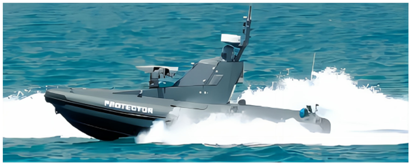
Figure 4.
The “Jinghai” USV.
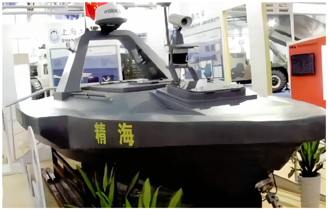
Figure 5.
DriX USVs operated from the shore-based remote operations center in the NOAA “Dual DriX” project (NOAA, public domain).
Figure 5.
DriX USVs operated from the shore-based remote operations center in the NOAA “Dual DriX” project (NOAA, public domain).
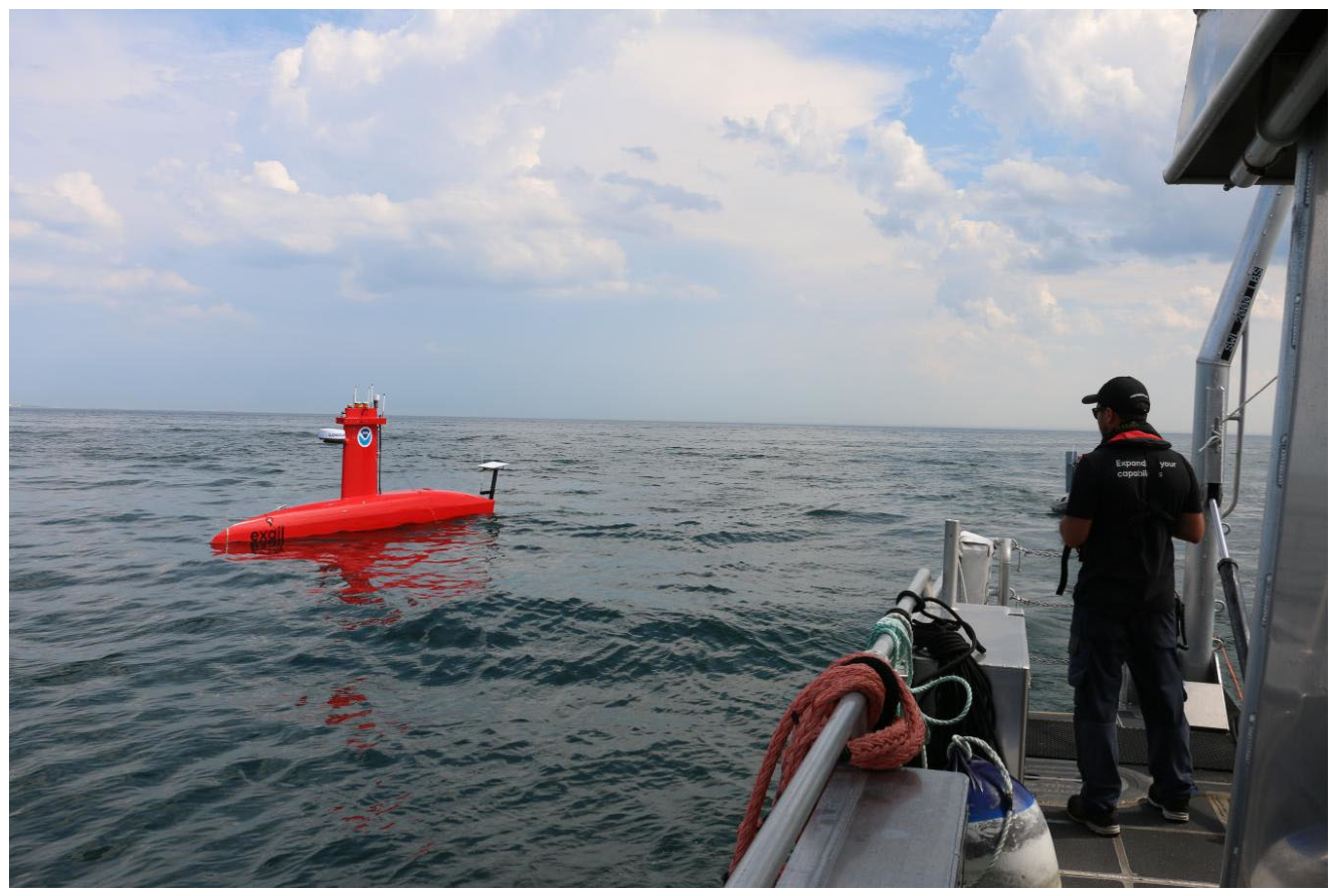
Figure 6.
Survey area and track lines of the “Dual DriX” project in the Gulf of Maine (NOAA, public domain).
Figure 6.
Survey area and track lines of the “Dual DriX” project in the Gulf of Maine (NOAA, public domain).
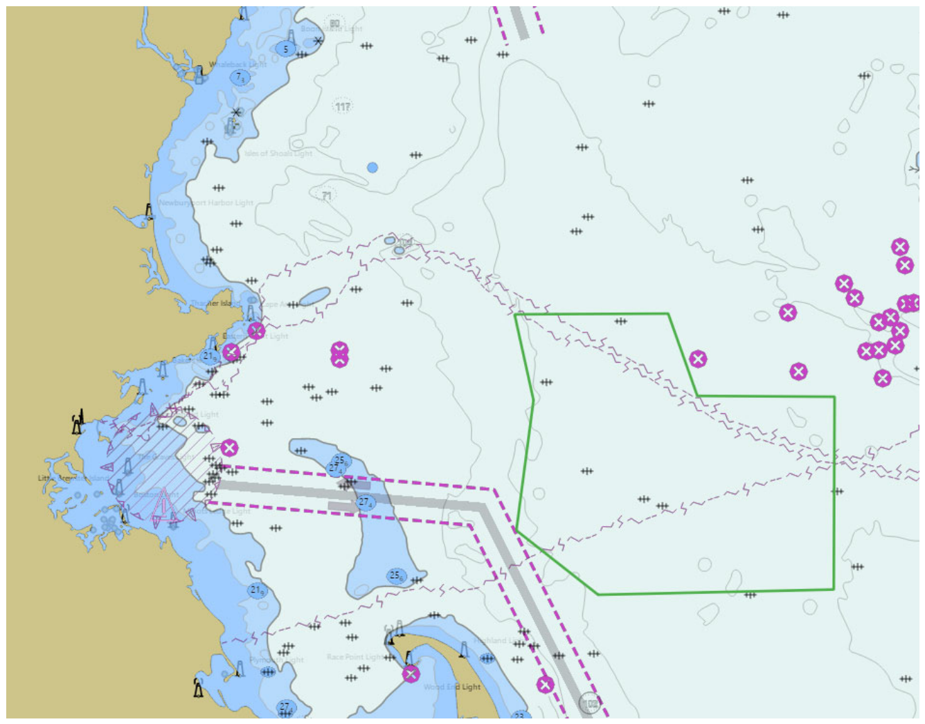
Figure 8.
The ABES autonomous USV: (a) rudderless thruster arrangement; (b) prototype during the lake trial (reproduced from Ref. [41], CC BY 4.0).
Figure 8.
The ABES autonomous USV: (a) rudderless thruster arrangement; (b) prototype during the lake trial (reproduced from Ref. [41], CC BY 4.0).
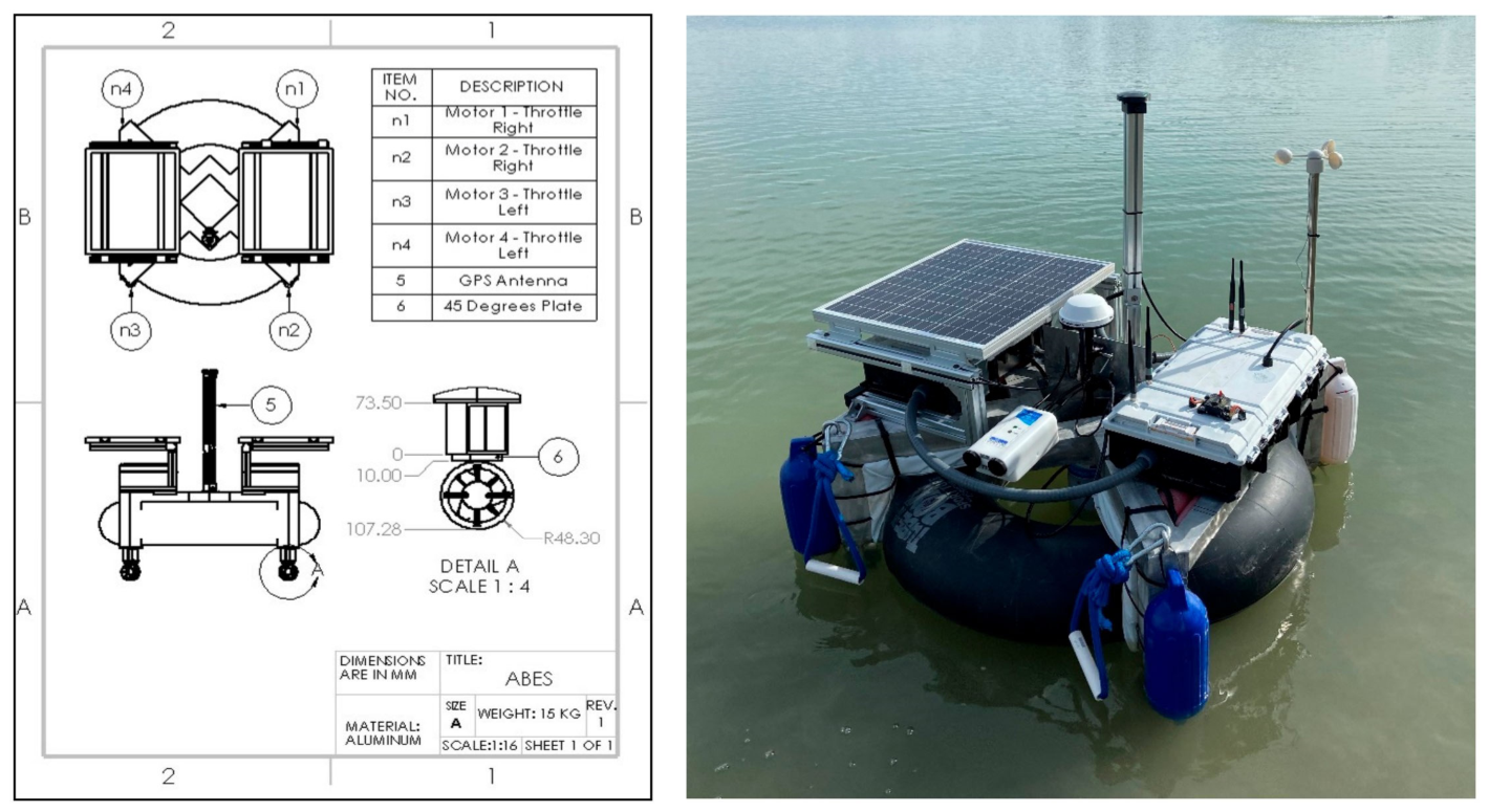
Figure 9.
Bathymetric results acquired by ABES in Ascarate Lake: (a) two-dimensional water depth map; (b) three-dimensional water depth map (reproduced from Ref. [41], CC BY 4.0).
Figure 9.
Bathymetric results acquired by ABES in Ascarate Lake: (a) two-dimensional water depth map; (b) three-dimensional water depth map (reproduced from Ref. [41], CC BY 4.0).
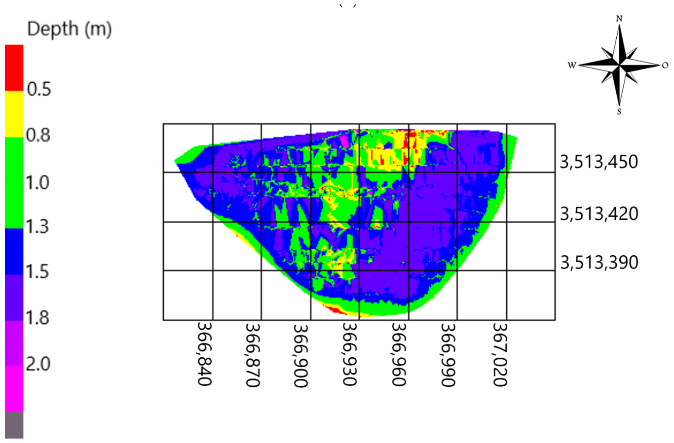
Figure 12.
The OpenSWAP autonomous surface vehicle during trials (reproduced from Ref. [33], CC BY 4.0).
Figure 12.
The OpenSWAP autonomous surface vehicle during trials (reproduced from Ref. [33], CC BY 4.0).
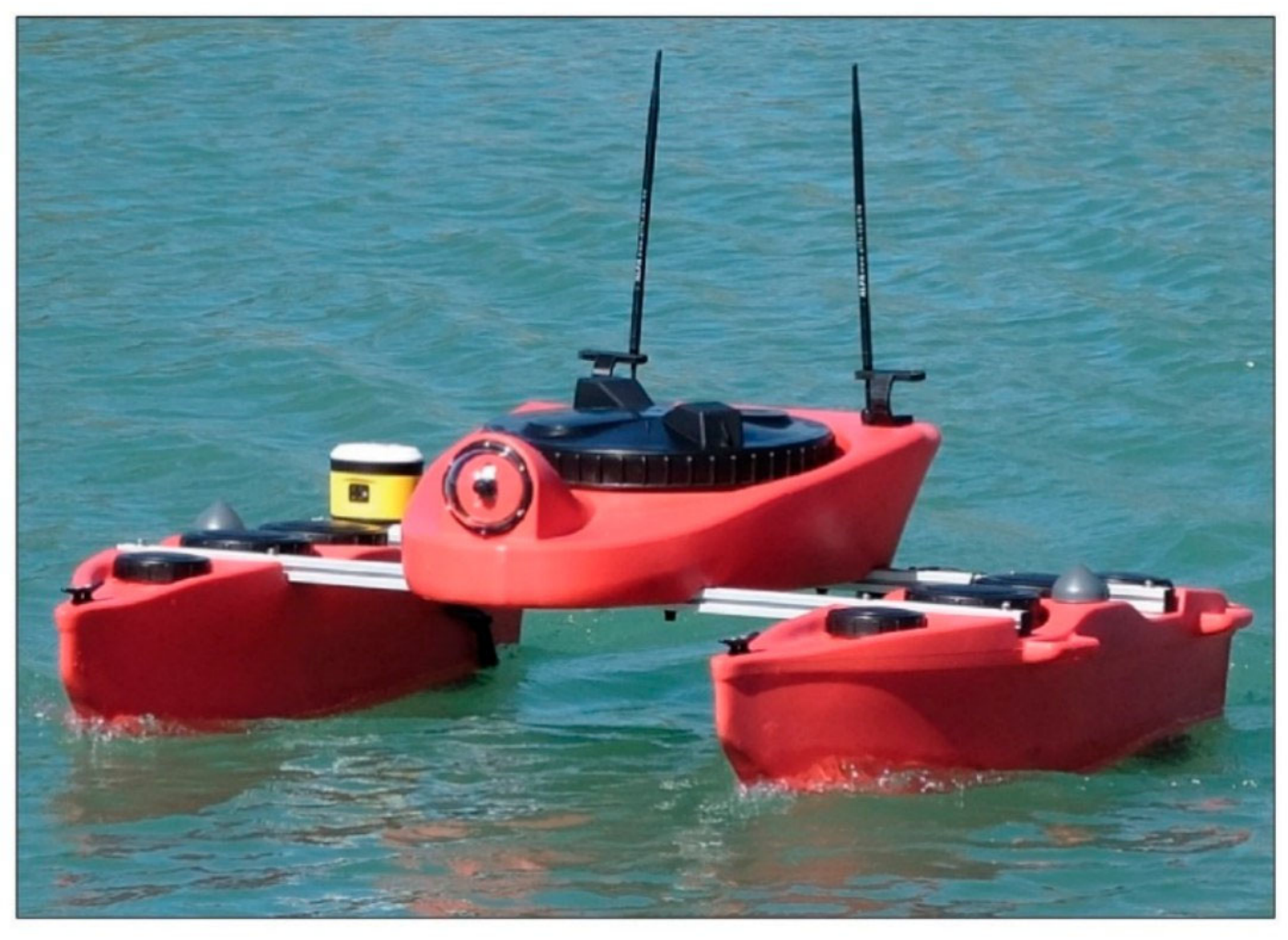
Figure 13.
Bathymetric results acquired by OpenSWAP with a Klein HydroChart 3500 multibeam echosounder and the repeated survey results of the following day (reproduced from Ref. [33], CC BY 4.0).
Figure 13.
Bathymetric results acquired by OpenSWAP with a Klein HydroChart 3500 multibeam echosounder and the repeated survey results of the following day (reproduced from Ref. [33], CC BY 4.0).
Disclaimer/Publisher’s Note: The statements, opinions and data contained in all publications are solely those of the individual author(s) and contributor(s) and not of MDPI and/or the editor(s). MDPI and/or the editor(s) disclaim responsibility for any injury to people or property resulting from any ideas, methods, instructions or products referred to in the content. |
© 2026 by the authors. Licensee MDPI, Basel, Switzerland. This article is an open access article distributed under the terms and conditions of the Creative Commons Attribution (CC BY) license (http://creativecommons.org/licenses/by/4.0/).
Copyright: This open access article is published under a Creative Commons CC BY 4.0 license, which permit the free download, distribution, and reuse, provided that the author and preprint are cited in any reuse.