

Submitted:
28 September 2026
Posted:
29 September 2026
You are already at the latest version
Abstract
In May 2023, the Emilia-Romagna region (northern Italy) was hit by two unexpected extreme weather events that caused 17 deaths, the displacing of 50,000 people, and damages amounting to over 10 billion euros. Such a geo-hydrological disaster has stimulated scientific investigation, and tens of papers have been published. In this review, peer-reviewed publications are examined with the aim of identifying critical issues relevant to the decision-making process. These questions are crucial for policy makers and territorial government agencies, who play a direct and fundamental role in disaster management. The review was performed in accordance with the PRISMA method and by the citation and indexing databases of Scopus and Web of Science (WoS). Its main findings are summarized as follows: (1) in flood and landslide mitigation, land-use planning adequate to the climate-adjusted scenarios must be designed and implemented; (2) early warning systems should be people-centered and based on more advanced weather forecasts or new methods, like the elaboration of cellular geo-referenced data; (3) the use of integrated approaches based on machine learning and other modern technologies is increasing being proposed to improve performance in disaster response. It can be concluded that the reviewed literature informs policy for improving government guidelines, rules, and decision-making in disaster management.
Keywords:
disaster management
; decision-making
; land-use planning
; early warning
; weather forecast
; integrated approach
1. Introduction
Floods and landslides are potential natural hazards, often triggered by severe rainfall and exacerbated by deforestation and land-use change. These geo-hydrological phenomena may become catastrophic, causing casualties, displacement, and infrastructure destruction [1,2]. Throughout the past two decades, statistical results indicate a clear upward trend in the number of deaths due to rainfall-triggered geological disasters globally [3,4]. Literature reviews can suggest new research topics and inform policy for defining and improving government guidelines, rules, and decisions [5,6]. By synthesizing knowledge on case studies, they can also identify consistent and inconsistent findings across publications or highlight gaps in key knowledge areas [7,8,9].
In May 2023, the Emilia-Romagna region (northern Italy) was hit by two unexpected extreme weather events that caused 17 deaths, the displacing of 50,000 people, and damages amounting to over 10 billion euros. The events sparked a heated political debate. Left-wing parties assigned great importance to the issue of climate change to explain floods and landslides. However, they downplayed their own responsibilities in regional government, omitting the fact that Emilia-Romagna is a leading Italian region in terms of land consumption [10,11]. Conversely, right-wing parties emphasized this latter aspect and essentially denied any responsibility for climate change [12].
The polarized debate has confused public opinion about the triggers of the geo-hydrological event, putting scholars in an inconvenient condition, and did not help to provide effective emergency guidance. On the other hand, it must be considered that the way the link between disasters and climate change is framed and communicated by media can influence policy decisions [see, e.g., 13,14]. After the relief phase, the debate was enriched with valuable technical insights, and several questions emerged. For example: the need to reduce land consumption and its waterproofing because of the expansion of residential areas was highlighted, with the aim of improving run-off [15,16]; the provision of real-time weather information and short-term weather forecasts to population was considered essential to enhance flood response capacity [17].
The purpose of this systematic review is to explore the scientific, peer-reviewed studies on 2023 Emilia-Romagna disaster to identify critical issues relevant to the different stages of the decision-making process. As is known from the literature, critical decision-making issues involve different problems, including cognitive, informational, and structural, that can lead to not optimal management choices. Their recognition is useful to improve disaster management (see, e.g., Refs. [18,19,20,21]). The paper is organized as follows: the case study is briefly described in Section 2; rationale for the review and method used are described in Section 3; results are exposed in Section 4; discussion is developed in Section 5; finally, conclusions are given in Section 6. The main findings highlighted the need to: (1) align land-use planning with scenarios that take climate change into account; (2) use people-centered early warning systems based on advanced weather forecasting; and (3) adopt integrated approaches, particularly during the disaster response phase.
2. Brief Description of the Case Study
The physical geographic setting of the Emilia-Romagna region is characterized by three sub-parallel altimetric zones: the Apennine Mountains, the central hills, and the Po Valley (Figure 1). Ten tributaries of the Po River cross the region from the Apennine watershed to the low valley (western sector); other rivers flow directly into the Adriatic Sea (eastern sector). They have an intermittent hydrological regime, with apparent interannual variability and strong fluctuations in flow between periods of flood (from the late autumn to early spring due to rainfall and snowmelt) and periods of drought (in the summer months). Lower discharges are close to null flowrate, especially downstream alluvial fans [22]. The foothill area is a subsiding syncline filled by thick alluvial deposits [23]. It is heavily anthropized, with cities, industries, cultivated fields and transport infrastructure.
The geo-hydrological phenomena of May 2023 were not predicted. The rainfall was the heaviest ever recorded, and it is estimated that similar events can only occur once every 200 years [25]. Several areas experienced return periods exceeding 500 years [26]. This means the probability of such events occurring each year is less than 0.5% [27]. Synoptic and Mesoscale conditions of the two May 2023 events were analyzed [26,28]. The first heavy rain occurred between 1 and 3 May, the second between 15 and 17 May. They were associated with cyclonic circulation, which remained stationary due to blocking subtropical anticyclones. The effect of convective systems was enhanced by the orographic barrier of the Apennines and the physical geographic characteristics of the Po Valley [28]. Between the 2 main rainfall events, there was low-medium intensity precipitation.
Given the extent of the phenomena, landscape impact was very different from place to place. Most of the 81,000 inventoried landslides occurred in the central hills. The density of hillslope movements reached value up to about 200 landslides per square kilometer [24]. Among these processes, the most significant were debris flows. Total flooded area was about 58 km2, with an average of 11 cm of standing water and some cases exceeding 68 cm in height. River basins in the eastern part of the region were most severely affected by the floods [26]. Ground conditions at the onset of the second extreme weather event contributed significantly to the flooding, as soil moisture content must have been high due to previous rainfall.
3. Rationale and Method
To protect human lives and material assets, it is essential to effectively plan the actions to be taken before, during, and after a catastrophic event. Disaster management is understood as a continuous cyclical process that aims to reduce risks, protect human lives, and limit material damage caused by natural and human-induced hazards. It is composed of the following stages: prevention, mitigation, preparedness, response and recovery [29]. Prevention and mitigation are generally considered as a single phase (cf., e.g., Refs. [30,31]). The actors of the disaster management process can intervene directly or indirectly. Agents and researchers play a direct role, while population and media usually play an indirect role. The public sector belongs to the agents, together with private industry, and voluntary organizations [32,33]. Three different levels of government are recognized. The first is the local level, closest to the disaster site and with the best knowledge of the affected area. Therefore, it should intervene first. If it fails to resolve the crisis (for example, due to a lack of resources or expertise), responsibility should be assumed by regional/provincial authorities and, ultimately, by national authorities. A further level of intervention can be identified, considering international agencies [33,34,35].
The decision-making process in disaster management is complex. The public sector agents must consider several reference points, such as the multiplicity of stakeholders, coordination and control principles, budget and resource availability, and inter-agency communication. Disasters are a set of interconnected events that usually occur in a rapidly changing context, under intense pressure, and in situations of critical or extreme stress. Supporting decision-making in disaster management is hard, as each decision involves multiple performers, different types of incidents, and the services engaged in those situations [36,37]. The complexity of the decision-making increases further during an unprecedented disaster, when authorities may also draw on hazard-specific expertise to support the decision, beyond established procedures. Nevertheless, the response phase to an unexpected disaster may require a non-traditional approach and tools based on non-hierarchical structure and flexibility [38,39].
The rationale behind the review was developed considering the current knowledge and state of the art on geo-hydrological disaster management. Classical approaches were linear and focused primarily on threshold water levels (see, e.g., Refs. [40,41,42,43]). At present, different criteria (including human, economic, and environmental), are often considered within a structured framework, even though they may conflict with each other [44,45]. To address the complex interconnections between causes and identify practical solutions, several research groups require a shift from linear to holistic integrated approaches, particularly systems thinking (see, e.g., Refs, [46,47]). However, over the past two decades, slow progress has occurred in applying systems thinking approaches in geo-hydrological disaster management compared to other fields like, as an example, water resources management [48].
To address the increasingly frequent occurrence of extreme weather events, many national authorities have developed a series of action plans and policy measures. These laws have some essential common elements. First, they establish the responsibilities and duties of local, regional, and national authorities during disaster emergencies, as well as procedural frameworks and coordination strategies for emergency responses. Second, they are structured to ensure rapid mobilization in organizing and coordinating the emergency rescue resources, so that the response phase can be conducted in an orderly and efficient manner [49]. To achieve this, weather monitoring systems, natural hazard warning systems, and response and relief mechanisms, based on large-scale models, artificial intelligence, and other technologies, are continuously being designed and improved [50,51]. In practice, the effectiveness of these tools is tested precisely during geo-hydrological emergencies. Hence the importance of identifying critical issues relevant to the whole decision-making process.
In this review, identification and selection of academic literature have been performed by the citation and indexing databases of Scopus and Web of Science (WoS), in accordance with the PRISMA method [52,53]. These commercial databases ensure accurate retrieval of scholarly writings, such as peer-reviewed journal articles, books, and conference proceedings [54]. Conversely, the limitations arising from their use are well known. These include the introduction of biases favoring the natural sciences and engineering at the expense of the social sciences and humanities, and the overrepresentation of English-language journals at the expense of other languages [55]. Database search modes are shown in Table 1.
The databases were last consulted on 25 September 2026, and 76 works were identified in total (Table 2). In several fields of research, including physical geography and natural hazard, Google Scholar can be a complementary tool for finding scholarly literature [56,57,58]. This free web search engine was then used to verify whether certain academic works had been overlooked by commercial databases. The following keywords were entered in Google Scholar search bar: “Emilia-Romagna”, “flood*”, “landslide*”, “precipitation”, “rain”, “meteorological event*”, and “2023”. Apart from the 76 studies previously identified, no other peer-reviewed writings relevant to this review were found.
Following the evaluation of the abstracts, a total of 42 documents were selected for full text analysis (Table 3). The high number of publications produced in three years shows that the 2023 geo-hydrological disaster in Emilia-Romagna has stimulated scientific production. Table 3 shows a summary of the selected documents. Twenty-four studies address the phases of flood management; eleven studies the phases of landslide management; the remaining seven studies do not present results relevant to the review.
Through Google and Google Scholar engines were retrieved technical reports, web pages, informal works, opinions, and other material produced outside of academic publishing and distribution channels (i.e., grey literature; see, e.g., Refs. [98,99]). A systematic analysis of this material is beyond the scope of this review. It has been used as a source of complementary information on the case study (Section 1, Section 2 and Section 5).
4. Results
The full text analysis of the selected documents was performed to identify critical decision-making issues for policy makers and territorial government agencies (Section 1), who play a direct and fundamental role in disaster management (Section 3). The relevant issues identified are outlined below according to the four operational phases (Section 3), addressing first flood management (Section 4.1) and subsequently landslide management (Section 4.2). To avoid exceeding a reasonable text length, a selection of them is presented. Please refer to the publications listed in Table 3 for full details of the authors’ findings.
4.1. Flood Management
Different authors have highlighted issues related to flood mitigation in Emilia-Romagna region. Cremonini et al. [26] argued that inadequate land-use planning and an underestimation of return periods were the primary causes of the expensive impacts on infrastructure resulting from the 2023 disaster. The assessment of the economic impact of floods, which is crucial for budget allocation, has been addressed by Di Noia et al. [69] using a computational input-output model. The model, however, is not without limitations stemming from simplifying assumptions. The importance of preserving the hydraulic functionality of riparian systems to mitigate floods has been considered by citizen science [75]. Such an approach can play a key role in strengthening communication among researchers, policy makers, and the public. Furthermore, involving volunteers in data collection can improve public perception of flood risk. Flood risk assessment has been addressed in remote sensing, hydrology, and engineering studies [77,78,79] (Table 3). All these present advanced approaches.
Issues regarding preparedness for severe flood events have been found in several works (Table 3). According to Cremonini et al. [26], to enable people threatened by hazards to act in a timely and appropriate manner, early warning systems had to be people-centered and based on more advanced weather forecasts. On the other hand, Di Paola et al. [70], based on a long-term analysis of precipitation (1974–2023), conclude that average precipitation associated with extreme events shows an increase in terms of both amount and frequency. In line with these insights, the need to use dynamically informed extreme event forecasting has been stressed [71]. The predictability of rainfall extreme could be improved using Lagrangian moisture analysis and event precursor analysis. Nevertheless, the use of appropriate hydrological and hydraulic models could facilitate the assessment of dangerous floods in near real time, thereby enhancing the preparedness of at-risk populations [72]. An innovative fiber optic system for monitoring river embankment was tested by Bertulessi et al. [63] during the 2023 Emilia-Romagna disaster. Such monitoring could prove useful for preparing for future events. Other questions regarding flood preparedness have been faced within the social sciences [75,84] and atmospheric sciences [28,97].
Regarding the response phase of flood management, Capano and D’Angelo [66] highlighted how the behavior of individual leadership played a decisive role in 2023 Emilia-Romagna disaster, regardless of political position about the primary factor behind the disaster (Section 1). From a social science point of view, Palazzoli et al. [84] discussed public perception and response to flood hazard, highlighting the need for community-focused interventions that integrate sociodemographic factors, past experiences, and effective risk communication to promote proactive behaviors. Using cellular geo-referenced data to provide real-time information to support the response phase, has been considered a critical issue [76,81]. The importance of advanced satellite techniques was emphasized by remote sensing-based research [85,86,93]. Such tools can provide managers with reliable daily maps of flooded areas. Finally, Valente et al. (2023, 2025) [95,96] addressed the issue of an effective response in regions characterized by an elderly resident population. These authors suggest a tight collaboration between local health authorities and academia for ongoing evaluations to enhance emergency management.
Post-flood recovery following the 2023 disaster in Emilia-Romagna has been analyzed primarily through remote sensing-based research (Table 3). Miakhil et al. [80] proposed an automated and sensor-flexible framework for continuous flood monitoring using multitemporal synthetic aperture radar (SAR) data. Maps generated after the 2023 disaster in Emilia-Romagna can be used for recovery operations. The integration of satellite imagery and in-situ data is supported to assess crop damage caused by flooding by Bocchino et al. [65]. This approach, based on data pre-processing and machine learning models, aims to go beyond traditional flood extent mapping, enabling a detailed and quantitative evaluation of damage severity. Still with reference to crop flood damage, De Feudis et al. [67] observed a negative effect on soil physical properties due to the higher silt content and lower organic carbon content of the flood-deposited sediment compared to the underlying soil. To overcome this critical issue, the authors suggest the addition of organic amendments due their cost–effectiveness.
4.2. Landslide Management
The first phase of landslide management, namely mitigation, has been faced by Rani et al. [89] using a deep learning approach that integrates precipitation time series into landslide probability modeling for various types of slope failure. To consider the precipitation conditions preceding the landslides, the authors focused on the month prior to the second landslide-triggering event (from 16 April 2023 to 17 May 2023). The results of this geomatics engineering study explain the distribution of landslides occurred in Emilia-Romagna in May 2023. It must be noted that the authors underline the underrepresentation of certain landslide types, particularly for rockslides, is a key limitation of the methodology they proposed. A second limitation on further use consists in the availability of extensive precipitation datasets for the areas under examination.
Notti et al. [83] introduce a two-stage methodology for mapping slope failures triggered by severe rainfall. In the preparedness and response phases, a GIS-based and user-friendly approach to map incipient landslides can be used. It is based on the difference between pre- and post-weather events of the Normalized Difference Vegetation Index obtained from free available satellite images. A limitation in its use is the availability of cloud-free images. Notti et al. [83] rapidly mapped potential ground effects in the aftermath of the 15–17 heavy rain event. As expected, cloud cover partially affected the results. Riche et al. (2026a) [90] developed a multi-agent system capable of transforming heterogeneous geospatial inputs into actionable intelligence for civil protection operations within minutes of image acquisition and processing. This system can be useful during the response phase. Its constraint lies in the inherent uncertainty of image-based landslide detection. Consequently, a small subset of little failures, low-contrast earth movements, or landslides partially obscured by vegetation or shadows might not be reliably identified.
Issues relevant to landslide recovery have been found in several works (Table 3). They have been addressed in geoscience, remote sensing and machine learning studies. Some authors inventoried the landslides caused by the geo-hydrological disaster examined through field surveys coupled with interpretation of satellite images [73] or photointerpretation of high-resolution aerial images [24]. The main limitations of these products lie in the presence of false positives and negatives, the duration of the proceedings, and the heavy workload. Other authors have explored automated techniques for the rapid mapping of landslides based on satellite imagery [59,68,74]. For each of these products, limited overall accuracy in landslide mapping was reported. Some machine learning methods have been developed for automated mapping and reporting [82,90,91,92]. Limitations of this approach are due to temporal gaps in the imagery, spectral ambiguity resulting from vegetation regrowth, and resolution discrepancies between ground truth and input data.
5. Discussion
The body of scientific studies on the 2023 Emilia-Romagna geo-hydrological disaster has addressed several critical issues relevant to decision-making. The importance of enhancing the public perception and preparedness for flood risk was particularly stressed [26,71,75,84]. To achieve such a goal, it must consider how this risk is perceived by people. Decision sciences usually define risk as a function of the probability and impact of potential future events. However, probability can entail more than mere statistics, just as impact can extend beyond economic costs. Risk perception becomes socially significant because people must act under conditions of uncertainty [100]. Living with natural processes that entail periodic hazards necessitates making choices, while differences in social and cultural characteristics can mean that some communities and individuals have far more options than others. It is precisely the uncertainty about these consequences, which can result in an improvement or a deterioration of our situation, that makes risk a matter of public debate. On the other hand, we cannot fully grasp the risks and threats posed by rainfall-triggered geological disasters against a scenario of intensifying severity, unpredictability, and frequency of heavy rainfall. Where there is significant gap between perceived risk and actual flood preparedness, institutional action should focus on bridging this discrepancy through practical, community-led initiatives [101].
Improper long-term land-use planning is an issue emphasized by authors in the reviewed literature [26,63]. This statement is consistent with the conclusions of the technical report commissioned by the regional authority in the aftermath of the disaster [102], which advocates for the adoption of measures aimed at reducing land consumption and restoring river floodplains. In practice, this would involve implementing the provisions of the European Floods Directive 2007/60/EC [103]. In densely populated flood-prone areas, planning aimed at managing agricultural land and, at the very least, limiting the construction of new buildings is mandatory [104]. The framework emerging for Emilia-Romagna following the 2023 geo-hydrological disaster is like that of other neighboring regions. If we aim to prevent casualties and mitigate damage to property and the environment, it is no longer possible to profoundly reshape the landscape and exacerbate hydrogeological risk conditions [105].
Regional planning must revise land use policies also to consider climate-adjusted scenarios [70,78]. The weather events that affected Emilia-Romagna in 2023 may become more frequent under a warmer climate, with important implications for the improvement of early warning systems as well [28]. Consequently, the risks and losses from extreme rainfall-triggered geological disasters would be increasingly severe, while current policies for responding to extreme weather events will have increasingly limited effectiveness in terms of disaster mitigation [3]. The 2023 disaster clearly demonstrated the need to enhance protection against flooding beyond the levels currently provided by existing infrastructures, that still fall short of the standards deemed optimal in planning. In this view, the construction of new flood-attenuation structures, as well as the sustainable management of riparian vegetation for watercourse maintenance, are of basic importance [102]. The effectiveness of this latter measure is being experimented and evaluated in areas facing similar issues (see, e.g., Refs. [106,107]).
The flood response phase, during which policy makers and agencies take actions to save lives and manage relief operations in the aftermath of the event, has been explored by several authors (Table 3). Two main themes emerge from this literature (Section 4): the use of cellular geo-referenced data to provide real-time information; and the importance of advanced satellite techniques to produce reliable daily maps of flooded areas. Integrating spatiotemporal social media posts in adequate text classification can form the groundwork for artificial intelligence applications [76]. However, it must consider that social media content may include false or misleading textual information [108,109,110]. Using the flood impact on cellular network service, calculated by change in radio reference signal received power and electromagnetic distance from serving cell, a civil protection application aimed at alerting the population can be designed [81]. An advantage of this methodology becomes apparent when considering that other warning systems, such as those based on satellite observations, can be affected by the presence of clouds [93]. However, the use of SAR data can enable high-resolution monitoring of flood events through acquisitions performed day and night, and regardless of cloud cover [85,86].
Despite reviewed literature mainly addressing flood management, significant works have been found also regarding landslide management (Section 3 and Section 4). Producing probability maps for each landslide type improves the accuracy of prediction and offers practical benefits for early warning systems and territorial planning [89]. In Emilia-Romagna region, landslide prevention requires medium-scale structural interventions, such as slope stabilization and surface water management works, complemented by the maintenance of forest areas and the adoption of suitable agricultural and livestock farming practices [102]. Effective landslide probability maps help define the extent and priority of areas requiring intervention, and, according to emerging literature, facilitate the communication of climate change-related risks and community adaptation planning [111,112]. If utilized in a timely manner, the mapping and survey of incipient landslides can serve as a useful management tool during preparedness and response phases (see, e.g., Refs. [113,114,115]). In the case of the 2023 Emilia-Romagna disaster, some authors have explored this possibility, highlighting its potential applications [83,90].
Due to machine learning applications, slope failure forecasting capacities have significantly improved through the last years, thus rainfall induced landslides can now be predicted a few days in advance [116,117]. Technological progress, ground-based and satellite remote sensing, telecommunications, computational capacity, and artificial intelligence have expanded monitoring coverage and enhanced early detection [118,119]. Notwithstanding the progress achieved, significant challenges persist in decision-making process. One of the most critical issues concerns the incompleteness and limited representativeness of landslide inventories. The 2023 Emilia-Romagna disaster, which caused approximately 81,000 landslides [24], including many in areas not previously identified as unstable [27], has raised basic questions regarding the predictive value of landslide inventory maps [120]. According to these authors, landslide inventories, environmental datasets, and monitoring data should be openly accessible, and shared in a timely manner, to strengthen public trust in policy decisions. A cultural-social change is also crucial. Policy makers and territorial government agencies must be aware of the complex nature of landslide hazards, and their environmental and socio-economic implications. Communication strategies must adopt a multi-hazard approach, highlighting interactions with floods, other potential natural hazards, and human activities [120].
Rebuilding priorities and long-term aid are crucial targets in landslide recovery. Deciding which communities or infrastructure projects get repaired first and managing resources as public attention fades and funding drops are complex tasks. An inventory of landslides triggered by geo-hydrological events is a fundamental prerequisite also for this issue, which is addressed in several reviewed papers (Table 3). Two types of approaches can be distinguished: those based on field surveys to interpret remote sensing images, and those employing automated techniques or machine learning methods for image processing (Section 4). Each of the methods has limitations that must be considered for their correct application. In addition, to reach more effective management capability, landslide inventory must be integrated with real-time monitoring and dynamic modeling [120].
Finally, with reference to the political debate about the responsibility of climate change on the 2023 Emilia-Romagna disaster (Section 1), communication research stated that: climate change has rarely been mentioned by media as a causal factor [Biancalana et al. 2026]; and no change in media coverage of climate change was observed before and after the events [121]. This appears surprising, given the exceptional nature of the event, and raises questions about the influence of media communication on political decisions (Section 1 and Section 2).
6. Conclusions
To achieve a direct impact on the management of geo-hydrological disasters, it is primarily essential to enhance technological capabilities for risk assessment, early warning, and the response phase as a whole. The examined literature highlights the following main critical issues: (1) in flood and landslide mitigation, land-use planning adequate to climate-adjusted scenarios must be designed and executed; (2) early warning systems should be people-centered and based on more advanced weather forecasts or new methods, like the elaboration of cellular geo-referenced data; (3) the use of integrated approaches, based on machine learning and other modern technologies, is essential to improve performance in disaster response. Further issues regard the use of: (4) citizen science methods to help preserving the hydraulic functionality of riparian systems and strengthening communication among researchers, policy makers, and the public; (5) remote sensing-based methods and machine learning applications to provide managers with daily maps of areas affected by floods or threated by landslides; (6) photointerpretation of high-resolution aerial images and automated techniques based on satellite imagery for the rapid mapping of landslides that are again subject to limitations.
Finally, it should be noted that the literature reviewed revealed neither inconsistent results across the various publications nor significant gaps in knowledge. Conversely, this literature provides useful information for improving government guidelines, rules, and decisions in the management of geo-hydrological disasters. Although the issues discussed were identified through a single case study, they could be relevant to similar cases worldwide.
Funding
This research received no external funding.
Conflicts of Interest
The author declares no conflicts of interest.
References
- Merz, B.; Bloschl, G.; Vorogushyn, S.; Dottori, F.; Aerts, J.C.J.H.; Bates, P.; Bertola, M.; Kemter, M.; Kreibich, H.; Lall, U.; Macdonald, E. Causes, impacts and patterns of disastrous river floods. Nat. Rev. Earth Environ. 2021, 2, 592–609. [Google Scholar] [CrossRef]
- Fidan, S.; Tanyas, H.; Akbas, A.; Lombardo, L.; Petley, D.N.; Gorum, T. Understanding fatal landslides at global scales: a summary of topographic, climatic, and anthropogenic perspectives. Nat. Hazards 2024, 120, 6437–6455. [Google Scholar] [CrossRef]
- Gao, H.; Xu, C.; Wu, S.; Wu, S.; Li, T.; Huang, Y. Has the unpredictability of geological disasters been increased by global warming? npj Nat. Hazards 2025, 2, 55. [Google Scholar] [CrossRef]
- Remondo, J.; Sanchez-Diaz, M.; Cuesta-Albertos, J.A. An increasing trend of landslides as a consequence of the global change. Earth Syst. Environ. 2026, 10, 1461–1474. [Google Scholar] [CrossRef]
- Olcina, J.; Sauri, D.; Hernandez, M.; Ribas, A. Flood policy in Spain: a review for the period 1983-2013. Disaster Prev. Manag. 2016, 25, 41–58. [Google Scholar] [CrossRef]
- Stanley, M.; Hotard, A.; Pilgreen, D.; Meyer, M. Critical Review of National Flood Policy Outcomes. J. Homel. Secur. Emerg. Manag. 2023, 20, 239–269. [Google Scholar] [CrossRef]
- Manning, S.; Kushma, J. A systematic review of the international disaster case management literature in the aftermath of Hurricane Katrina. Int. J. Emerg. Manag. 2016, 12, 241–262. [Google Scholar] [CrossRef]
- Dykes, A.P.; Bromhead, E.N. The Vaiont landslide: re-assessment of the evidence leads to rejection of the consensus. Landslides 2018, 15, 1815–1832. [Google Scholar] [CrossRef]
- Orimoogunje, O.; Aniramu, O. Systematic review of flood resilience strategies in Lagos Metropolis: pathways toward the 2030 sustainable development agenda. Front. Clim. 2025, 7, 1603798. [Google Scholar] [CrossRef]
- Peccol, E.; Movia, A. Evaluating land consumption and soil functions to inform spatial planning. 3rd International Conference on Degrowth for Ecological Sustainability and Social Equity, Venice (Italy), 19-23 September 2012; p. 11 pp. [Google Scholar]
- Zullo, F.; Di Pietro, G.; Cattani, C.; Montaldi, C. Urban planning vs. agricultural production: a study on the Po Valley. Land 2023, 12, 902. [Google Scholar] [CrossRef]
- Imperatore, P.; Frazzetta, F. Narratives of extreme weather events as a field of conflict: a media comparison between the Emilia Romagna and Marche floods. Ital. Political Sci. 2024, 18, 316–337. [Google Scholar]
- Lahsen, M.; Ribot, J. Politics of attributing extreme events and disasters to climate change. Wiley Interd. Rev. Clim. Change 2022, 13, e750. [Google Scholar] [CrossRef]
- Buelow, F.A.; Brower, A.; Cradock-Henry, N. Framing resilience: Post-disaster communication in Aotearoa-New Zealand. Int. J. Disaster Risk Reduct. 2025, 117, 105167. [Google Scholar] [CrossRef]
- Bonora, P. Cronache dall’Emilia Romagna nel fango. Doc. Geogr. (In Italian) 2023, 43, 653–656. [Google Scholar]
- Spizzichino, D.; Munafo, M. Il dissesto nello scenario di un clima mutato. Ecoscienza (in Italian). 2023, 14(5), 73–75. [Google Scholar]
- Cacciamani, C. Eventi estremi. Il ruolo della meteorologia nazionale. Ecoscienza (In Italian) 2023, 14(5), 76–77. [Google Scholar]
- Halsnæs, K.; Kaspersen, P.S. Decomposing the cascade of uncertainty in risk assessments for urban flooding reflecting critical decision-making issues. Clim. Change 2018, 151, 491–506. [Google Scholar] [CrossRef]
- Pezzica, C.; Cutini, V.; Bleil de Souza, C. Mind the gap: State of the art on decision-making related to post-disaster housing assistance. Int. J. Disaster Risk Reduct. 2021, 53, 101975. [Google Scholar] [CrossRef]
- Ma, K.; Yan, H.; Ye, Y.; Zhou, D.; Ma, D. Critical Decision-Making Issues in Disaster Relief Supply Management: A Review. Comput. Intell. Neurosci. 2022, 2022, 1105839. [Google Scholar] [CrossRef] [PubMed]
- Muccione, V.; Lontzek, T.; Huggel, C.; Ott, P.; Salzmann, S. An application of dynamic programming to local adaptation decision-making. Nat. Hazards 2023, 119, 523–544. [Google Scholar] [CrossRef]
- Allodi, A.; Angelo, L.; Bordini, F.; Branchi, M.; Comune, E.; Del Longo, M.; Nicolosi, G.; Noberini, M.; Pizzera, F.; Pugliese, A.; et al. Hydrology across Disciplines: Organization and Application Experiences of a Public Hydrological Service in Italy. Climate 2022, 10, 32. [Google Scholar] [CrossRef]
- Eid, C.; Benetatos, C. Geological and hydrogeological review of the uppermost part of the Emilia-Romagna alluvial plain. GEAM Geoing. Ambient. Min. 2023, 170, 24–30. [Google Scholar]
- Berti, M.; Pizziolo, M.; Scaroni, M.; Generali, M.; Critelli, V.; Mulas, M.; Tondo, M.; Lelli, F.; Fabbiani, C.; Ronchetti, F.; Ciccarese, G.; Dal Seno, N.; Ioriatti, E.; Rani, R.; Zuccarini, A.; Simonelli, T.; Corsini, A. RER2023: the landslide inventory dataset of the May 2023 Emilia-Romagna meteorological event. Earth Syst. Sci. Data 2025, 17, 1055–1074. [Google Scholar] [CrossRef]
- Barnes, C.; Faranda, D.; Coppola, E.; Grazzini, F.; Zachariah, M.; Lu, C.; Kimutai, J.; Pinto, I.; Pereira, C.M.; Sengupta, S.; Vahlberg, M.; Singh, R.; Heinrich, D.; Otto, F. Limited net role for climate change in heavy spring rainfall in Emilia-Romagna. Available online. Imperial College, London, 2023. (accessed on Day Month Year). [CrossRef]
- Cremonini, L.; Randi, P.; Fazzini, M.; Nardino, M.; Rossi, F.; Georgiadis, T. Causes and Impacts of Flood Events in Emilia-Romagna (Italy) in May 2023. Land 2024, 13, 1800. [Google Scholar] [CrossRef]
- Brath, A.; Casagli, N.; Marani, M.; Mercogliano, P.; Motta, R. Rapporto della Commissione tecnico-scientifica istituita con deliberazione della Giunta regionale n. 984/2023 e determinazione dirigenziale 14641/2023, al fine di analizzare gli eventi meteorologici estremi del mese di maggio 2023; (technical report, in Italian); Regione Emilia-Romagna: Bologna, Italy, 12 December 2023. [Google Scholar]
- Scoccimarro, E.; Borrelli, A.; Sangelantoni; Cavicchia, L.; Pasqui, L.; Tibaldi, M.; Boccaletti, S. A cul-de-sac effect makes Emilia-Romagna more prone to floods in a changing climate. Sci. Rep. 2025, 15, 36823. [Google Scholar] [CrossRef] [PubMed]
- Poser, K.; Dransch, D. Volunteered geographic information for disaster management with application to rapid flood damage estimation. Geomatica 2010, 64, 89–98. [Google Scholar]
- Bosher, L.; Chmutina; van Niekerk, D. Stop going around in circles: towards a reconceptualization of disaster risk management phases. Disaster Prev. Manag. 2021, 30, 525–537. [Google Scholar] [CrossRef]
- Al-Jebzi, R.; Cochrane, L. Flood risks and resilience planning in Qatar for expected climatic change: A systematic review of the literature. Sustain. Environ. 2025, 11, 2483030. [Google Scholar] [CrossRef]
- Kreps, G.A. The organization of disaster response: core competences and processes. Int. J. Mass Emerg. Disasters 1983, 13, 439–465. [Google Scholar]
- Lettieri, E.; Masella, C.; Radaelli, G. Disaster management: findings from a systematic review. Disaster Prev. Manag. 2009, 18, 117–136. [Google Scholar] [CrossRef]
- Aryal, K.; Dobson, O. A case study from the National Disaster Management Institute in the Republic of Korea. Aust. J. Emerg. Manag. 2011, 26, 34–44. [Google Scholar]
- Dhungana, G.; Pal, I. Assessing the role of international agencies in disaster governance in Nepal. Prog. Disaster Sci. 2025, 26, 100421. [Google Scholar] [CrossRef]
- Bostick, T.P.; Holzer, T.H.; Sarkani, S. Enabling stakeholder involvement in coastal disaster resilience planning. Risk Anal. 2017, 37, 1181e200. [Google Scholar] [CrossRef] [PubMed]
- Arifah, A.; Tariq, M.; Juni, M.H. Decision making in disaster management cycle of natural disasters: a review. Int. J. Public Health Clin. Sci. 2019, 6, 1e18. [Google Scholar] [CrossRef]
- Kapucu, N.; Garayev, V. Collaborative Decision-Making in Emergency and Disaster Management. Int. J. Public Admin. 2011, 34, 366–375. [Google Scholar] [CrossRef]
- Curnin, S.; Brooks, B.; Owen, C. A case study of disaster decision-making in the presence of anomalies and absence of recognition. J. Conting. Crisis Manag. 2020, 28, 110–121. [Google Scholar] [CrossRef]
- Martelloni, G.; Segoni, S.; Fanti, R.; Catani, F. Rainfall thresholds for the forecasting of landslide occurrence at regional scale. Landslides 2012, 9, 485–495. [Google Scholar] [CrossRef]
- De Vita, P.; Napolitano, E.; Godt, J.W.; Baum, R.L. Deterministic estimation of hydrological thresholds for shallow landslide initiation and slope stability models: case study from the Somma-Vesuvius area of southern Italy. Landslides 2013, 10, 713–728. [Google Scholar] [CrossRef]
- Hassan, H.; Mazlan, M.I.Q.; Ibrahim, T.N.T.; Kambas, M.F. IOT System: Water Level Monitoring for Flood Management. IOP Conf. Ser. Mater. Sci. Eng. 2020, 917, 012037. [Google Scholar] [CrossRef]
- Xue, W.; Wu, Z.; Xu, H.; Wang, H.; Ma, C.; Zhou, Y. A framework for amplification flood risk assessment and threshold determination of combined rainfall and river level in an inland city. J. Hydrol. 2024, 640, 131725. [Google Scholar] [CrossRef]
- De Brito, M.M.; Evers, M. Multi-criteria decision-making for flood risk management: a survey of the current state of the art. Nat. Hazards Earth Syst. Sci. 2016, 16, 1019–1033. [Google Scholar] [CrossRef]
- da Silva, L.B.L.; Alencar, M.H.; de Almeida, A.T. Multidimensional flood risk management under climate changes: Bibliometric analysis, trends and strategic guidelines for decision-making in urban dynamics. Int. J. Disaster Risk Reduct. 2020, 50, 101865. [Google Scholar] [CrossRef]
- Perrone, A.; Inam, A.; Albano, R.; Adamowski, J.; Sole, A. A participatory system dynamics modeling approach to facilitate collaborative flood risk management: A case study in the Bradano River (Italy). J. Hydrol. 2020, 580, 124354. [Google Scholar] [CrossRef]
- Laurien, F.; Martin, J.G.; Mehryar, S. Climate and disaster resilience measurement: persistent gaps in multiple hazards, methods, and practicability. Clim. Risk Manag. 2022, 37, 100443. [Google Scholar] [CrossRef]
- Awah, L.S.; Belle, J.A.; Nyam, Y.S.; Orimoloye, I.R. A Systematic Analysis of Systems Approach and Flood Risk Management Research: Trends, Gaps, and Opportunities. Int. J. Disaster Risk Sci. 2024, 15, 45–57. [Google Scholar] [CrossRef]
- Gao, H.; Xu, C.; Wang, W.; Xiao, Z.; He, X. Prevention and Defense Technologies for Natural Disasters: A Review. Evid. Earth Sci. 2025, 1, 17–32. [Google Scholar] [CrossRef]
- Kuglitsch, M.M.; Cox, J.; Luterbacher, J.; Jamoussi, B.; Xoplaki, E.; Thummarukudy, M.; Radwan, G.S.; Yasukawa, S.; McClain, S.N.; Albayrak, R.A.; Oehmen, D.; Ward, T. AI to the rescue: how to enhance disaster early warnings with tech tools. Nature 2024, 634, 27–29. [Google Scholar] [CrossRef] [PubMed]
- Du, B.; Wang, Y.; Fang, Z.; Liu, G.; Tian, Z. Spatiotemporal modeling and projection framework of rainfall-induced landslide risk under climate change. J. Environ. Manag. 2025, 373, 123474. [Google Scholar] [CrossRef] [PubMed]
- Moher, D.; Liberati, A.; Tetzlaff, J.; Altman, D.G.; PRISMA Group. Preferred reporting items for systematic reviews and meta-analyses: The PRISMA statement. Biomed. J. 2009, 339, b2535. [Google Scholar]
- Page, M.J.; McKenzie, J.E.; Bossuyt, P.M.; Boutron, I.; Hoffmann, T.C.; Mulrow, C.D.; Shamseer, L.; Tetzlaff, J.M.; Akl, E.A.; Brennan, S.E.; et al. The PRISMA 2020 statement: An updated guideline for reporting systematic reviews. Biomed. J. 2021, 372, 71. [Google Scholar] [CrossRef] [PubMed]
- Pranckute, R. Web of Science (WoS) and Scopus: The Titans of Bibliographic Information in Today’s Academic World. Publications 2021, 9, 12. [Google Scholar] [CrossRef]
- Mongeon, P.; Paul-Hus, A. The journal coverage of Web of Science and Scopus: a comparative analysis. Scientometrics 2016, 106, 213–228. [Google Scholar] [CrossRef]
- Stirbu, S.; Thirion, P.; Schmitz, S.; Haesbroeck; G. Greco, N. The utility of Google Scholar when searching geographical literature: comparison with three commercial bibliographic databases. J. Acad. Libr. 2015, 41, 322–329. [Google Scholar] [CrossRef]
- Nemeth, N.; Johnson, M.S.; Mocatta, G.; Hawley, E. Communicational responses for compound natural hazards: A systematic review. Int. J. Disaster Risk Reduct. 2024, 115, 105041. [Google Scholar] [CrossRef]
- Walters, W.H. Comparing conventional and alternative mechanisms of discovering and accessing the scientific literature. Proc. Natl. Acad. Sci. U.S.A. 2025, 122, e2503051122. [Google Scholar] [CrossRef] [PubMed]
- Alruqimi, M.; Riche, A.; Confuorto, P.; Guermoui, M.; Bianchini, S.; Melgani, F. From Landslide Detection to Multi-Source LLM-Based Reporting: A Complete Framework for Rapid Assessment of Post-Disaster Scenarios. Remote Sens. 2026, 18, 1821. [Google Scholar] [CrossRef]
- Arrighi, C.; Domeneghetti, A. Brief communication: On the environmental impacts of the 2023 floods in Emilia-Romagna (Italy). Nat. Hazards Earth Syst. Sci. 2024, 24, 673–679. [Google Scholar] [CrossRef]
- Bentivogli, R.; Carlini, C.; Costantini, F.; Fabbri, E.; Gianbastiani, B.M.S.; Greggio, N.; et al. Short-term recovery of inland and marine environments after the 2023 Emilia-Romagna flood. Commun. Earth Environ. 2026, 7, 513. [Google Scholar] [CrossRef]
- Berti, M.; Pizziolo, M.; Scaroni, M.; Generali, M.; Olivucci, S.; Gozza, G.; et al. Testing NDVI and U-Net for automated mapping of multiple-occurrence regional landslide events using satellite and aerial multispectral data (Casola Valsenio, Emilia-Romagna, Northern Apennines, Italy). Landslides 2026, 23, 969–988. [Google Scholar] [CrossRef]
- Bertulessi, M.; Ceccato, F.; Ioli, F.; Barbieri, F.; Pinto, L.; Simonini, P.; Menduni, G. Field Testing of a Smart Geomat Based on Fiber Optic Sensors and Sensor Fusion for Levee Monitoring. J. Flood Risk Manag. 2025, 18, e70070. [Google Scholar] [CrossRef]
- Biancalana, C.; Conte, S.; Ladini, R.; Legnante, G.; Loreti, D. Climate change and attribution in Italian TV news coverage of the Emilia-Romagna flood: a missing story? Contemp. Ital. Politics 2026, 18, 2673164. [Google Scholar]
- Bocchino, F.; Belloni, V.; Ravanelli, R.; Zaccarini, C.; Crespi, M.; Lindenbergh, R. Crop flood damage assessment integrating Sentinel-2 imagery and in situ data: the 2023 Emilia-Romagna case. Remote Sens. Appl. Soc. Environ. 2026, 41, 101852. [Google Scholar] [CrossRef]
- Capano, G.; D′Angelo, A. Local responses to the threats of dramatic crises: do institutional leaders make a difference, and if so, how? Disasters 2026, 50, e70059. [Google Scholar] [CrossRef] [PubMed]
- De Feudis, M.; Trenti, W.; Manfredi, P.; Cassinari, C.; Vianello, G.; Vittori Antisari, L. Negative impact of alluvial sediments on physical properties of agricultural soils affected by flooding in May 2023 in Emilia Romagna Region (Northern Italy). J. Soils Sediments 2025, 25, 103–115. [Google Scholar] [CrossRef]
- Dal Seno, N.; Ciccarese, G.; Evangelista, D.; Loli Piccolomini, E.; Corsini, A.; Berti, M. Rapid landslide mapping during the 2023 Emilia-Romagna disaster: assessing automated approaches with limited training data. Nat. Hazards Earth Syst. Sci. 2026, 26, 4101–4129. [Google Scholar] [CrossRef]
- Di Noia, J.; Caiani, A.; Cesarini, L.; Arosio, M.; Monteleone, B. A high resolution input–output model to assess the economic impact of floods. J. Econ. Behav. Organ. 2025, 230, 106896. [Google Scholar] [CrossRef]
- Di Paola, F.; Cimini, D.; De Natale, M.P.; Gallucci, D.; Gentile, S.; Geraldi, E.; et al. The May 2023 flood in Emilia-Romagna and 50-year trends in extreme precipitation based on ERA5-Land. J. Hydrol. Reg. Stud. 2026, 63, 103070. [Google Scholar] [CrossRef]
- Dorrington, J.; Wenta, M.; Grazzini, F.; Magnusson, L.; Vitart, F.; Grams, C. M. Precursors and pathways: dynamically informed extreme event forecasting demonstrated on the historic Emilia-Romagna 2023 flood. Nat. Hazards Earth Syst. Sci. 2024, 24, 2995–3012. [Google Scholar] [CrossRef]
- Ferrari, A.; Passadore, R.; Vacondio, R.; Carniello, L.; Pivato, M.; Crestani, E. Brief communication: Hydrological and hydraulic investigation of the extreme September 2024 flood on the Lamone River in Emilia-Romagna, Italy. Nat. Hazards Earth Syst. Sci. 2025, 25, 2473–2479. [Google Scholar] [CrossRef]
- Ferrario, M.F.; Livio, F. Rapid Mapping of Landslides Induced by Heavy Rainfall in the Emilia-Romagna (Italy) Region in May 2023. Remote Sens. 2024, 16, 122. [Google Scholar] [CrossRef]
- Filipponi, F.; Iadanza, C.; Vivaldi, V.; Zucca, F.; Meisina, C.; Ferrario, M.F.; Trigila, A. Hybrid pixel-based and object-based image analysis approach for landslides rapid mapping: the extreme rainfall in Emilia-Romagna (Italy) May 2023 case study. Nat. Hazards 2025, 121, 22549–22580. [Google Scholar] [CrossRef]
- Gumiero, B.; Veronesi, L.; Galgani, L.; Di Grazia, F.; Corsi, A.; Cirrone, R.G.; Loiselle, S.A. Citizen-engaged research for improved perceptions of riparian systems. Open Res. Eur. 2025, 5, 89. [Google Scholar] [CrossRef] [PubMed]
- Hanny, D.; Schmidt, S.; Gandhi, S.; Granitzer, M.; Resch, B. A multimodal GeoAI approach to combining text with spatiotemporal features for enhanced relevance classification of social media posts in disaster response. Big Earth Data 2026, 10, 258–302. [Google Scholar] [CrossRef]
- Isundwa, F.K.; Marino, A.; Berardi, A.; Bovolo, C.I.; Hunter, P.; Neil, C.; et al. Optimizing Change Detection Methods for Flood Mapping Using Polarimetric SAR. IEEE J. Sel. Top. Appl. Earth Obs. Remote Sens. 2025, 18, 29450–29463. [Google Scholar] [CrossRef]
- Jahangiri, F.; Ahmadi, R.; Sahebi, D.; Bayat, E.; Shirgir, A. Flood Hydrology Shifts in the Savio Catchment Under Hydroclimatic Variability. In Innovation in Urban and Regional Planning; De Lotto, R., Venco, E., Pietra, C., Eds.; Springer: Cham, Switzerland, 2026; pp. 148–159. [Google Scholar]
- Marchi, M.; Bertolini, I.; Tonni, L.; Morreale, L.; Colombo, A.; Simonelli, T.; Gottardi, G. An Extensive Italian Database of River Embankment Breaches and Damages. Water 2025, 17, 2202. [Google Scholar] [CrossRef]
- Miakhil, S.U.; Velasquez Hurtado, W.A.; Tapete, D.; Gamba, P. Unsupervised Continuous Flood Mapping From Multitemporal, Multiview, and Multisensor SAR Sequences. IEEE J. Sel. Top. Appl. Earth Obs. Remote Sens. 2026, 19, 24395–24417. [Google Scholar] [CrossRef]
- Muratore, G.; Micheli, D.; Arena, D.; Galati, A.; Piacco, S.; Verdone, R. Flood Impact on Cellular Electromagnetic Propagation. IEEE Access 2024, 12, 1–9. [Google Scholar] [CrossRef]
- Necula, L.; Porumb, L.; Jocea, A.F.; Raducanu, D. Independent Multi-Sensor Validation of Machine-Learning Landslide Susceptibility: Footprint Construction Decides the Verdict—May 2023 Emilia-Romagna Event. Remote Sens. 2026, 18, 2318. [Google Scholar] [CrossRef]
- Notti, D.; Cignetti, M.; Godone, D.; Cardone, D.; Giordan, D. The unsuPervised shAllow laNdslide rapiD mApping: PANDA method applied to severe rainfalls in northeastern Appenine (Italy). Int. J. Appl. Earth Obs. Geoinf. 2024, 129, 103806. [Google Scholar] [CrossRef]
- Palazzoli, I.; Puglisi, C.; Binelli, C.; Murrarak, R.; Ceola, S. Public perceptions and responses to flood risk: Evidence from the 2023 flood events in Italy. Int. J. Disaster Risk Reduct. 2026, 132, 105981. [Google Scholar] [CrossRef]
- Pulvirenti, L.; Squicciarino, G.; Cenci, L.; Virelli, M.; Candela, L.; Puca, S. Daily Monitoring of the May 2023 Emilia-Romagna Flood Using Cosmo-SkyMed Data. IEEE International Geoscience and Remote Sensing Symposium, Athens, Greece, 7–12 July 2024; pp. 1358–1361. [Google Scholar]
- Pulvirenti, L.; Squicciarino, G.; Cenci, L.; Ferraris, L.; Virelli, M.; Candela, L.; Puca, S. Continuous flood monitoring using on-demand SAR data acquired with different geometries: Methodology and test on COSMO-SkyMed images. ISPRS J. Photogramm. Remote Sens. 2025, 225, 382–401. [Google Scholar] [CrossRef]
- Qadri, J.; Ceccato, F. Exploring the Interaction Between Landslides and Carbon Stocks in Italy. Sustainability 2024, 16, 11273. [Google Scholar] [CrossRef]
- Qadri, J.; Ceccato, F. Quantifying Flood Impacts on Ecosystem Carbon Dynamics Using Remote Sensing and Machine Learning in the Climate-Stressed Landscape of Emilia-Romagna. Water 2025, 17, 3001. [Google Scholar] [CrossRef]
- Rani, R.; Dahal, A.; Berti, M.; Lombardo, L. Transformer, more than meets the eye: A deep learning approach to integrate rainfall time-series in multi-type landslide probability modelling. Geosci. Front. 2026, 17, 102295. [Google Scholar] [CrossRef]
- Riche, A.; Zeggada, A.; Caleca, F.; Alruqimi, M.; Confuorto, P.; Guermoui, M.; Bianchini, S.; Tofani, V.; Melgani, F. MAS-LAND: A multi-agent system for landslide detection and rapid response. Int. J. Disaster Risk Reduct. 2026, 143, 106263. [Google Scholar] [CrossRef]
- Riche, A.; Confuorto, P.; Guermoui, M.; Bianchini, S. Robust automated detection of small-scale rainfall-induced landslides in Italy Using SegFormer and high-resolution satellite imagery. Sci. Rep. 2026, 16, 27203. [Google Scholar] [CrossRef] [PubMed]
- Riche, A.; Zeggada, A.; Alruqimi, M.; Confuorto, P.; Guermoui, M.; Bianchini, S.; Melgani, F. Comparing Loss Functions for Segformer-Based Landslide Segmentation. 2026 IEEE Mediterranean and Middle-East Geoscience and Remote Sensing Symposium (M2GARSS), Marrakech, Morocco, 2026; pp. 11–15. [Google Scholar]
- Satriano, V.; Ciancia, E.; Pergola, N.; Tramutoli, V. A First Extension of the Robust Satellite Technique RST-FLOOD to Sentinel-2 Data for the Mapping of Flooded Areas: The Case of the Emilia Romagna (Italy) 2023 Event. Remote Sens. 2024, 16, 3450. [Google Scholar] [CrossRef]
- Schiliro, L.; Bosman, A.; Caielli, G.M.; Corazza, A.; Crema, S.; Di Salvo, C.; Gaudiosi, I.; Mancini, M.; Norini, G.; Peronace, E.; et al. The May 2023 Rainstorm-Induced Landslides in the Emilia-Romagna Region (Northern Italy): Considerations from UAV Investigations Under Emergency Conditions. Geosciences 2025, 15, 101. [Google Scholar] [CrossRef]
- Valente, M.; Zanellati, M.; Facci, G.; Zanna, N.; Petrone, E.; Moretti, E.; et al. Health System Response to the 2023 Floods in Emilia-Romagna, Italy: A Field Report. Prehosp. Disaster Med. 2023, 38, 813–817. [Google Scholar] [CrossRef] [PubMed]
- Valente, M.; Del Prete, C.; Facci, G.; Martino, A.; Grilli, G.R.; Bravi, F.; Reno, C.; Ragazzoni, L. The 2023 floods in the Emilia-Romagna Region, Italy: A retrospective qualitative investigation into response strategies and criticalities. Int. J. Disaster Risk Reduct. 2025, 116, 105089. [Google Scholar] [CrossRef]
- Wu, H.T.; Hartmuth, K.; Wernli, H. Performance of the operational ECMWF ensemble in predicting heavy rain associated with the Emilia-Romagna flood in May 2023. Weather 2026, 81, 172–177. [Google Scholar] [CrossRef]
- Cooper, K.; Marsolek, W.; Riegelman, A.; Farrell, S.; Kelly, J. Grey literature: use, creation, and citation habits of faculty researchers across disciplines. J. Librariansh. Sch. Commun. 2019, 7, eP2314. [Google Scholar] [CrossRef]
- Khalil, H.; Johns-Hayden, A.; Kynoch, K. Guidance to including gray literature in systematic reviews-recommendations from an epidemiological study. J. Clin. Epidemiol. 2026, 194, 112222. [Google Scholar] [CrossRef] [PubMed]
- Eiser, J.R.; Bostrom, A.; Burton, I.; Johnston, D.M.; McClure, J.; Paton, D.; van der Pligt, J.; White, M.P. Risk interpretation and action: A conceptual framework for responses to natural hazards. Int. J. Disaster Risk Reduct. 2012, 1, 5–16. [Google Scholar] [CrossRef]
- Joumar, N.; Gaganis, C.M.; Tourlioti, P.N.; Pantelakis, I.; Tzoraki, O.; Benaabidate, L.; El Messari, J.E.S.; Gaganis, P. Understanding Public Perception and Preparedness for Flood Risks in Greece. Water 2025, 17, 764. [Google Scholar] [CrossRef]
- Brath, A. Alluvione in Emilia Romagna, il Rapporto Tecnico. Ecoscienza (In Italian) 2024, 2-2024, 40–48. [Google Scholar]
- Santato, S.; Bender, S.; Schaller, M. The European Floods Directive and Opportunities offered by Land Use Planning. CSC Report 12, 2013; Climate Service Center, Germany: Hamburg.
- Genovese, E.; Thaler, T. The benefits of flood mitigation strategies: effectiveness of integrated protection measures. AIMS Geosci. 2020, 6, 459–472. [Google Scholar] [CrossRef]
- Mandarino, A.; Faccini, F.; Terrone, M.; Paliaga, G. Anthropogenic landforms and geo-hydrological hazards of the Bisagno Stream catchment (Liguria, Italy). J. Maps 2021, 17, 122–135. [Google Scholar] [CrossRef]
- Croke, J.; Thompson, C.; Fryirs, K. Prioritising the placement of riparian vegetation to reduce flood risk and end-of-catchment sediment yields: Important considerations in hydrologically-variable regions. J. Environ. Manag. 2017, 190, 9–19. [Google Scholar] [CrossRef] [PubMed]
- Rillo Migliorini Giovannini, M.; Lama, G.F.C.; Scopetani, L.; Francalanci, S.; Volpe Signorile, A.; Saracino, R.; Preti, F. Evaluating the Impacts of Riparian Plants on Flood Hazard Within Vegetated Rivers. J. Flood Risk Manag. 2025, 18, 70063. [Google Scholar] [CrossRef]
- Buntain, C.; Golbeck, J. Automatically identifying fake news in popular Twitter threads. 2017 IEEE International Conference on Smart Cloud (Smart-Cloud), New York, NY, USA, 2017; pp. 208–215. [Google Scholar]
- Zhang, X.; Ghorbani, A.A. An overview of online fake news: Characterization, detection, and discussion. Inf. Process. Manag. 2020, 57, 102025. [Google Scholar] [CrossRef]
- Durr Missau, L. The Role of Social Sciences in the Study of Misinformation: A Bibliometric Analysis of Web of Science and Scopus Publications (2017-2022). Tripodos 2024, 56, 141–166. [Google Scholar] [CrossRef]
- Chu, F.Y.; Chen, C.W.; Li, H.C. Assessing landslide probability changes under climate change scenarios as a basis for adaptation strategies. Bull. Eng. Geol. Environ. 2026, 85, 650. [Google Scholar] [CrossRef]
- Jin, J.; Xue, Z.; Xu, C.; Li, L.; Feng, L.; Yang, Z.; Xu, X.; Wang, J.; Sun, Q.; Zhang, Z.; Zhu, D.; Li, H.; Gong, Bo. From Rainfall to Absolute Landslide Probability: A Machine Learning–Based Approach. Nat. Hazards Rev. 2026, 27, 2545. [Google Scholar] [CrossRef]
- Dellow, G.; Yetton, M.; Massey, C.; Archibald, G.; Barrell, D.J.A.; Bell, D.; et al. Landslides caused by the 22 February 2011 Christchurch earthquake and management of landslide risk in the immediate aftermath. Bull. N. Z. Soc. Earthq. Eng. 2011, 44, 227–238. [Google Scholar] [CrossRef]
- Schiliro, L.; Esposito, C.; Scarascia Mugnozza, G. Evaluation of shallow landslide-triggering scenarios through a physically based approach: an example of application in the southern Messina area (northeastern Sicily, Italy). Nat. Hazards Earth Syst. Sci. 2015, 15, 2091–2109. [Google Scholar] [CrossRef]
- Li, H.; Samsudin, N.A. A systematic review of landslide research in urban planning worldwide. Nat. Hazards 2025, 121, 6391–6411. [Google Scholar] [CrossRef]
- Mondini, A.C.; Guzzetti, F.; Melillo, M. Deep learning forecast of rainfall-induced shallow landslides. Nat. Commun. 2023, 14, 2466. [Google Scholar] [CrossRef] [PubMed]
- Strnad, D.; Mongus, D.; Horvat, S.; Segina, E. A multi-task deep learning approach for landslide displacement prediction with applications in early warning systems. Sci. Rep. 2026, 16, 196. [Google Scholar] [CrossRef] [PubMed]
- Casagli, N.; Intrieri, E.; Tofani, V.; Gigli, G.; Raspini, F. Landslide detection, monitoring and prediction with remote-sensing techniques. Nat. Rev. Earth Environ. 2023, 4, 51–64. [Google Scholar] [CrossRef]
- Abhinaya, B.; Shruthi, K.; Ashok Kumar, P.; Roshni, D.; Naresh Reddy, G.; Prasanna, M. Landslide Prediction Using AI Techniques and Satellite Imagery. International Conference on Communication and Smart Devices, Ranchi, India, 25-26 July 2025; pp. 1–5. [Google Scholar]
- Guzzetti, F.; Berti, M.; Reichenbach, P.; Tofani, V. Landslide risk management in Italy: practices, advances, and future directions. Rend. Fis. Acc. Lincei 2025, 36, 1165–1173. [Google Scholar] [CrossRef]
- Legnante, G.; Bordignon, M.; Baretto, C.; Conte, S.; Sassi, S. A multifaceted issue: The coverage and politicization of the climate change issue on Italian television. Ital. Political Sci. 2025, 19, 92–110. [Google Scholar]
Figure 1.
Geographic scheme of the Emilia-Romagna region. Rivers (in blue) and 1–17 May 2023 isohyets (in red, from [24], mod.) are reported.
Figure 1.
Geographic scheme of the Emilia-Romagna region. Rivers (in blue) and 1–17 May 2023 isohyets (in red, from [24], mod.) are reported.
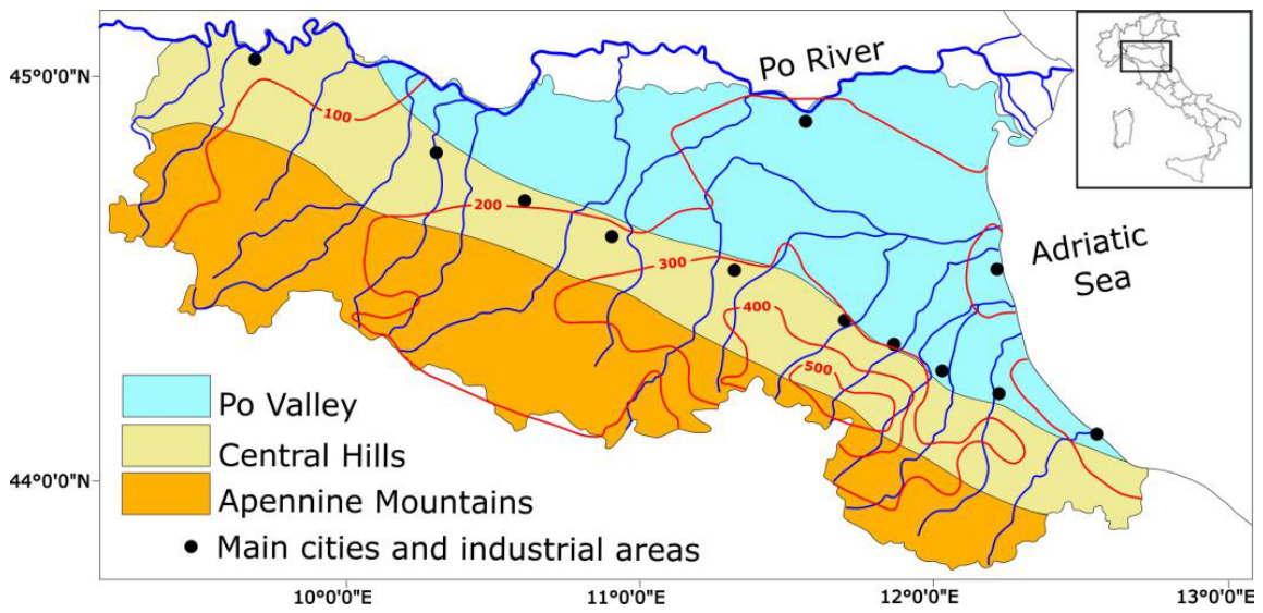

Table 1.
Scopus/Wos database search model.
| Search Field | Search Phrase | Document Type | |
|---|---|---|---|
| Scopus | TITLE-ABS-KEY (Article Title, Abstract, and Keywords) | (TITLE-ABS-KEY (Emilia-Romagna OR “Emilia Romagna”) AND TITLE-ABS-KEY (flood* OR landslide* OR precipitation OR rain OR “meteorological event*”) AND TITLE-ABS-KEY (2023)) | Article, Conference Paper, Conference Review, Review, Book Chapter. |
| WoS | TS = Topic (Title, Abstract, Author Keywords, and Keyword Plus) | (((TS = (“Emilia-Romagna” OR “Emilia Romagna”) AND ALL = (flood* OR landslide* OR precipitation OR rain OR “meteorological event*”) AND ALL = (2023)) | Articles, Review Articles, Proceedings Papers, Early Access, Book Chapters. |
Table 2.
Summary of identification, selection, and full-text examination stages.
| Scopus | WoS | ||
|---|---|---|---|
| Database mined documents After duplicate check Documents found in both databases Identified documents |
57 57 |
47 76 |
72 72 |
| Excluded after abstract evaluation Selected documents |
16 |
34 42 |
33 |
Table 3.
Summary of documents selected for full-text analysis.
| Author(s) and Year | Source* | Main Research Field | Hazard and management phase** |
|---|---|---|---|
| Alruqimi et al. (2026) [59] Arrighi and Domeneghetti (2024) [60] Bentivogli et al. (2026) [61] Berti et al. (2025) [24] Berti et al. (2026) [62] Bertulessi et al. (2025) [63] Biancalana et al. (2026) [64] Bocchino et al. (2026) [65] Capano and D’Angelo (2026) [66] Cremonini et al. (2024) [26] De Feudis et al. (2024) [67] Del Seno et al. (2026) [68] Di Noia et al. (2025) [69] Di Paola et al. (2026) [70] Dorrington et al. (2024) [71] Ferrari et al. (2025) [72] Ferrario and Livio (2024) [73] Filipponi et al. (2025) [74] Gumiero et al. (2025) [75] Hanny et al. (2026) [76] Isundwa et al. (2025) [77] Jahangiri et al. (2026) [78] Marchi et al. (2025) [79] Miakhil et al. (2026) [80] Muratore et al. (2024) [81] Necula et al. (2026) [82] Notti et al. (2024) [83] Palazzoli et al. (2026) [84] Pulvirenti et al. (2024) [85] Pulvirenti et al. (2025) [86] Qadri and Ceccato (2024) [87] Qadri and Ceccato (2025) [88] Rani et al. (2026) [89] Riche et al. (2026a) [90] Riche et al. (2026b) [91] Riche et al. (2026c) [92] Satriano et al. (2024) [93] Schiliro et al. (2025) [94] Scoccimarro et al. (2025) [28] Valente et al. (2023) [95] Valente et al. (2025) [96] Wu et al. (2026) [97] |
S, W S, W S, W S, W S, W S S, W S, W S, W S, W S, W W S, W S, W S, W S, W S, W S, W S S, W S, W S, W S, W S, W S, W S, W S, W S, W S, W S, W S, W S, W S, W S, W S, W S S, W S, W S, W S, W S, W S, W |
remote sensing environmental science environmental science geoscience remote sensing engineering political science remote sensing political science environ. science agronomy remote sensing economic science atmospheric science atmospheric science hydrology remote sensing remote sensing social science social science remote sensing hydrology engineering remote sensing engineering machine learning remote sensing social science remote sensing remote sensing machine learning machine learning geomatic engineering machine learning machine learning machine learning remote sensing geoscience atmospheric science health science health science atmospheric science |
L4 NR NR L4 NR F2 NR F4 F3 F1, F2 F4 L4 F1 F2 F2 F2 L4 L4 F1 F2, F3 F1 F1 F1 F4 F3 L4 L2, L3 F2, F3 F3, F4 F3, F4 NR NR L1 L3 L4 L4 F3, F4 NR F2 F3 F3 F2 |
* S = Scopus; W = Web of Science. ** F = flood; L = landslide; 1 = mitigation; 2 = preparedness; 3 = response; 4 = recovery; NR = Findings not relevant to the review.
Disclaimer/Publisher’s Note: The statements, opinions and data contained in all publications are solely those of the individual author(s) and contributor(s) and not of MDPI and/or the editor(s). MDPI and/or the editor(s) disclaim responsibility for any injury to people or property resulting from any ideas, methods, instructions or products referred to in the content. |
© 2026 by the authors. Licensee MDPI, Basel, Switzerland. This article is an open access article distributed under the terms and conditions of the Creative Commons Attribution (CC BY) license (http://creativecommons.org/licenses/by/4.0/).
Copyright: This open access article is published under a Creative Commons CC BY 4.0 license, which permit the free download, distribution, and reuse, provided that the author and preprint are cited in any reuse.