

Submitted:
21 September 2026
Posted:
22 September 2026
You are already at the latest version
Abstract
Background: Artisanal and small-scale gold mining (ASGM) enterprises in Zimbabwe generate a continuous stream of geological, operational, processing and financial data through the ordinary course of daily work, yet almost none of this data is captured, integrated or analysed in a way that supports decision-making, producing a paradox in which mines possess data but not information, and information but not intelligence. Objective: This paper proposes a Big Data Analytics framework for artisanal and small-scale mining (the ASM-BDA Framework) that converts routinely generated, fragmented records into actionable geological, operational and business intelligence, and sets out a protocol for testing it empirically. Approach: The framework is developed conceptually from the knowledge-discovery-in-databases literature, the big-data “seven Vs”, and mineral resource classification standards, and is illustrated, not yet empirically tested, using the geology, structural evaluation and historical records of Unit 5 Gold Mine near Kwekwe. A mixed-methods research design is proposed, combining quantitative analysis of production and geological data across a sample of fifteen to thirty small-scale gold mines with semi-structured interviews of owners, geologists and technical service providers. Contribution: The paper contributes a conceptual framework, a set of testable propositions on resource sterilisation, and a practical, piloted-but-not-yet-fielded data-collection protocol for data-driven decision support in a sector that has, to date, been studied mainly through the lenses of informality, finance and formalisation policy. No empirical results are reported in this version of the manuscript.
Keywords:
artisanal and small-scale mining
; big data analytics
; data mining
; mineral resource management
; resource sterilisation
; Zimbabwe
; Unit 5 Gold Mine
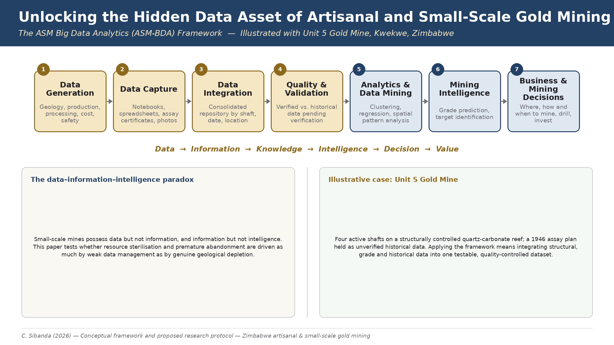
A graphical abstract summarising the ASM-BDA Framework and the Unit 5 Gold Mine illustrative case is submitted as a separate PNG file accompanying this manuscript.
Manuscript type: Conceptual framework and proposed research protocol (mining engineering / mineral resource management). This manuscript has not been peer reviewed. It presents a conceptual framework and a proposed research protocol; no primary field data have yet been collected under this protocol.
1. Introduction
Zimbabwe's artisanal and small-scale gold mining (ASGM) sector has become the dominant source of the country's gold output. Fidelity Gold Refinery figures for 2025 show small-scale producers delivering 34.9 tonnes of gold, nearly three times the 11.8 tonnes produced by large-scale mining companies, and government, industry and development partners have responded with a fresh wave of formalisation initiatives, including the 2025 Mines and Minerals Bill and the planet-GOLD Zimbabwe project.
Much of the academic and policy literature on ASGM formalisation and performance in Zimbabwe and across sub-Saharan Africa has concentrated on land access, licensing, finance, mercury use, environmental degradation and safety. A smaller but long-standing strand of that literature has identified information itself as a binding constraint: as early as 2004, Hilson and Maponga showed that a shortage of census and geological information had impeded the regularisation of artisanal and small-scale mining. Two decades later, small-scale mines in Zimbabwe still generate the bulk of their geological and operational records in notebooks, WhatsApp messages, spreadsheets, assay certificates and production books, and rarely convert those records into an integrated analytical resource.
This paper starts from a simple but under-explored observation: a working small-scale gold mine is not short of data. It is short of the systems and analytical capability needed to convert that data into decisions. The paper proposes a Big Data Analytics and Data Mining framework tailored to the operating realities of ASGM, and illustrates the argument using the geology, structural mapping and historical records of Unit 5 Gold Mine, a small-scale gold project near Kwekwe in Zimbabwe's Midlands Province.
2. Statement of the Problem
A small-scale gold mine generates data every day through geological mapping, reef and channel measurements, assay results, shaft depths, underground development, face positions, reef widths, dip and strike readings, tonnes mined and processed, head and tailings grades, recovery, reagent consumption, milling performance, water and fuel consumption, labour and equipment hours, gold produced and sold, operating costs, accidents, and the geological structures, faults, fractures, alteration zones and historical workings encountered underground.
Individually, each of these records appears to be an ordinary operational entry. Collectively, accumulated over months and years across several shafts, they constitute a substantial and largely untapped data asset. The problem is that this information is rarely integrated into a usable analytical system. It sits in notebooks, phones, loose spreadsheets, assay certificates, hand-drawn maps, production books and the memories of miners and supervisors, disconnected from one another and from the decisions they should inform.
This creates what may be described as a data-information-intelligence paradox: the mine has data but not information, and it has information but not intelligence. Where this paradox persists, technically sound orebodies can be poorly developed, diluted, and under-recovered and, in the worst cases, abandoned as “mined out” when the underlying constraint was analytical rather than geological.
3. Literature Review
3.1. The Information Gap in Artisanal and Small-Scale Mining
The formalisation literature has long recognised inadequate geological and census information as a structural constraint on ASM development. Hilson and Maponga's foundational analysis argued that a shortage of geological and demographic data hindered the regularisation of the sector, a finding echoed in subsequent formalisation scholarship by Hilson and Maconachie, who caution that formalisation efforts are frequently undermined by the same informational and institutional gaps that motivated them in the first place. Zimbabwe-focused work, including Pact Institute's scoping study of gold mining in Shurugwi and Kadoma districts and more recent formalisation roadmaps, continues to describe a sector operating largely on paper-based records, informal planning and limited technical support, even as government geologists provide routine site visits and free geological advice to registered miners.
This body of work consistently asks how ASM can be made to collect more or better data, whether through census exercises, licensing conditions or extension services. It has paid comparatively little attention to a related but distinct question: what happens to the data that small-scale mines are already generating in the ordinary course of production, and why does so little of it become usable intelligence.
3.2. Big Data and Data Mining in the Wider Mining Industry
Outside the artisanal sector, large-scale mining companies have moved decisively toward data-driven operation. Industry analyses describe mining data as arising from both direct measurement sources, such as geodetic surveys and GPS, and indirect or ancillary sources, such as fleet management systems, process control data and geological modelling outputs, with orebody modelling techniques used to translate these sources into drilling and development targets. Consultants advising major miners have argued that the industry's central opportunity lies in using the large volumes of data it already collects, particularly given that only a small fraction of any orebody can ever be directly sampled before it is mined, so predictive and machine-learning methods are increasingly used to manage the natural variability of ore bodies. Recent industry commentary extends this to prospectivity mapping, where machine-learning techniques process core logs and remote-sensing data to identify mineral corridors, and to intelligent resource estimation, where integrated geospatial and historical data are used to build more dynamic grade models than traditional manual sampling allows.
These capabilities remain concentrated in large, well-capitalised operations. Small-scale mines rarely have the systems, software licences or technical staff that underpin big data analytics at the industrial scale described in this literature. Yet the underlying data-generating activities, mapping, sampling, assaying, production recording, are structurally similar at any scale. This suggests that a scaled-down, appropriately designed analytics framework, rather than the enterprise systems used by major mining houses, may be transferable to the ASGM context.
3.3. The Vocabulary of Big Data: From Three Vs to Seven
The characterisation of big data by a growing list of “Vs” originates with Laney's early definition of data challenges in terms of volume, velocity and variety. IBM subsequently added veracity, in response to clients' concerns about the quality and trustworthiness of the data sources feeding their big data initiatives, producing a widely used four-Vs formulation. Microsoft and other analysts extended this further to include variability, capturing the number of inconsistencies and shifting meanings within a dataset, and visualisation or visibility, capturing the need for a complete, interpretable picture of the data to support decision-making. A seven-Vs formulation, adding value as the culminating dimension, that is, the extent to which the preceding six characteristics can actually be converted into a benefit for the organisation, is now common in both technical and management-oriented big data literature, although some authors extend the list further still to ten or more Vs. This paper adopts the seven-Vs formulation used in Section 4 because it is the most widely recognised version in applied big data literature and maps cleanly onto the mine-level data categories described in Section 2, while remaining aware that veracity and variability, in particular, are treated inconsistently across sources and therefore require explicit local definition for the ASGM context.
3.4. Data Mining and Knowledge Discovery in Databases
The analytical core of the proposed framework draws on the knowledge discovery in databases (KDD) literature. Fayyad, Piatetsky-Shapiro and Smyth defined KDD as the non-trivial process of identifying valid, novel, potentially useful and ultimately understandable patterns in data, and distinguished it from data mining, which they treat as the specific pattern-extraction step, using methods such as classification, regression, clustering and association-rule mining, that sits within the broader KDD process of data selection, pre-processing, transformation, mining and interpretation. This distinction matters for the ASM-BDA Framework: Stages 1 to 4 (data generation, capture, integration and quality control) correspond to the selection, pre-processing and transformation steps of the KDD process, while Stage 5 (analytics and data mining) corresponds to the pattern-extraction step proper, and Stages 6 and 7 correspond to the interpretation and knowledge-consolidation steps that Fayyad and colleagues treat as integral to KDD but separate from data mining itself. Framed this way, a common failure mode in small-scale mining is not an absence of Stage 5 technique, but an absence of the governance work in Stages 1 to 4 that any data mining method depends on.
3.5. Mineral Resource Classification as a Data Governance Problem
The internationally recognised JORC Code and the analogous NI 43-101 standard classify Mineral Resources, in order of increasing geological confidence, into Inferred, Indicated and Measured categories, according to the quantity, density and quality of the sampling and geological evidence available and the confidence with which continuity of mineralisation can be interpreted. An Inferred Mineral Resource is defined as that part of a resource estimated on the basis of limited geological evidence and sampling, with lower confidence than an Indicated or Measured Mineral Resource. This classification system is, in effect, a formal data-governance standard: it does not simply describe geology, it describes the adequacy of the data underpinning a geological interpretation, and it withholds compliant resource status from mineralisation, however promising, until the evidentiary basis has been verified. This paper adopts the same underlying logic, distinguishing verified project data from historical records pending verification, as illustrated by the treatment of Unit 5's 1946 assay plan in Section 5, and argues that ASGM enterprises can benefit from applying a simplified, proportionate version of this data-confidence hierarchy to their routine production and geological records, independent of whether they are pursuing a formal, compliant resource estimate.
3.6. Digital and Geospatial Data Collection in African Artisanal Mining
A separate strand of recent literature has used remote sensing, satellite imagery, unmanned aerial systems and mobile data-collection tools to address information gaps in African artisanal mining, generally from the outside in, that is, to help governments, researchers and non-governmental organisations map, monitor and regulate ASM activity that is otherwise poorly documented. Studies applying convolutional neural networks to satellite imagery across Sub-Tropical West Africa, small unmanned aerial systems to map informal mining features in data-sparse tropical environments, and mobile phone-based data collection in African survey research all demonstrate the feasibility of digital data capture in resource-constrained, informal settings comparable to Zimbabwean ASGM. This literature has been directed mainly at external oversight, governance and revenue-leakage concerns, for example estimates that artisanal and small-scale mining contributes only a small share of formal government revenue relative to its share of production, rather than at the internal decision-making of the mining enterprise itself. The ASM-BDA Framework proposed in this paper is complementary to, but distinct from, this monitoring-oriented literature: its unit of analysis and primary beneficiary is the mine and its owners and technical staff, not an external regulator, even though the same underlying digital tools, mobile data capture, GPS-referenced mapping and structured databases, are relevant to both purposes.
3.7. Positioning This Paper
This paper occupies the space between these literatures. It takes the ASM formalisation literature's diagnosis of an information gap seriously, but reframes it: the binding constraint may lie less in an absence of data than in the absence of a framework for capturing, integrating and mining data that small-scale mines already generate. It borrows the KDD process model and the seven-Vs vocabulary from the general data mining and big data literature, borrows the verified-versus-unverified data-confidence logic from mineral resource classification standards, and borrows the demonstrated feasibility of low-cost digital data capture from the geospatial ASM-monitoring literature, and combines these into a single framework adapted to the resource constraints, informality and scale of artisanal and small-scale gold mining enterprises.
4. Conceptual Framework: The ASM Big Data Analytics (ASM-BDA) Framework
The paper proposes a seven-stage framework, termed the ASM-BDA Framework, that traces the movement of routinely generated mine data from raw event to management decision. The stages are summarised in Table 1.
The framework's underlying logic is a progression from data to information, from information to knowledge, from knowledge to intelligence, and from intelligence to decisions and value. Data governance, comprising capture, quality control and integration, sits at the centre of the framework, because without it, analytics and data mining have nothing reliable to work on. This is consistent with this paper's use of a JORC/NI 43-101 style distinction between verified project data and historical data pending verification, discussed further in Section 6, which allows a mine to use unverified historical records analytically while flagging them clearly as unverified.
4.1. The Seven Characteristics of ASM Data
The established “seven Vs” used to characterise big data, volume, velocity, variety, veracity, value, variability and visualisation, translate directly onto the data environment of a small-scale gold mine, as set out in Table 2.
Framed this way, ASGM should not be characterised as data-poor. It is more accurately described as data-underutilised: a sector that generates data with genuine big-data characteristics but lacks the governance, tools and skills to convert that data into intelligence.
5. Illustrative Case: Unit 5 Gold Mine
Unit 5 Gold Mine (Mine Registration Number 30068) is a structurally controlled, quartz-carbonate vein-hosted small-scale gold project located approximately 20 kilometres west of Kwekwe on the Silobela Road, within the Kwekwe Greenstone Belt of the Zimbabwe Craton. The mine operates four active shafts targeting high-grade mineralisation where a north-south trending main reef, dipping approximately 45 degrees east with a strike length of around 600 metres and a pinch-and-swell vein width of 0.5 to 2 metres, intersects a series of east-west transverse structures. These intersections form a structural dilation model in which ore shoots are concentrated at reef junctions rather than distributed evenly along strike. Faulting recurs at approximately 20-metre intervals along strike, three distinct joint sets have been mapped, and the average fracture frequency is around 3 metres, all of which are exactly the kind of structural observations that, if systematically logged and analysed across shafts, could reveal predictable patterns in ore shoot location and continuity.
Unit 5 also illustrates the historical-data problem directly. A 1946 assay plan for the mine, recorded on a degraded photocopy showing No. 1 and No. 2 Shaft levels, reports a 40-metre wide mineralised zone at a grade of 19 grams per tonne at the main shaft, alongside separate historical references to production grades of up to 600 grams per tonne. Neither figure can currently be treated as a compliant resource estimate; both are classified, in the mine's 2026 Geology and Structural Evaluation Report, as historical records pending verification rather than verified project data, consistent with JORC and NI 43-101 style reporting conventions. This is precisely the situation described in Section 2: a genuine data asset, in this case an eighty-year-old assay plan, exists but cannot yet be converted into intelligence because it has not been captured into a structured, quality-controlled dataset alongside current sampling, mapping and structural data.
Applied to Unit 5, the ASM-BDA Framework points to a concrete analytical agenda: integrating current structural mapping, fault spacing, joint sets and channel-sample results from all four shafts into a single spatial dataset; testing statistically whether reef width, dip variation and proximity to transverse structures predict grade, in line with the structural dilation model already used qualitatively to target ore shoots; and treating the 1946 historical data not as a curiosity but as a candidate input for verification sampling and drilling, so that its apparent high grades can be confirmed, downgraded or discarded on an evidentiary basis rather than left as an unverified anecdote. None of this requires large-scale enterprise software; it requires a disciplined data governance step, of the kind set out in Stage 3 and Stage 4 of the framework, applied consistently across the mine's existing four shafts.
6. The Resource Sterilisation Hypothesis
A recurring pattern in small-scale mining can be described as a sequence running from a high-grade zone, through a poor development decision, to excessive dilution, poor recovery, cash-flow difficulty and, ultimately, abandonment of the working. The mine owner typically concludes that the gold has been exhausted. The geological reality may instead be that the resource was never properly understood, because the structural and grade data needed to understand it were never integrated or analysed.
Data mining applied to routinely collected mine data could, in principle, identify recurring high-grade intersections, structural controls on mineralisation, grade shoots, reef continuity, predictable fault offsets, relationships between reef width and grade, relationships between depth and grade, spatial clustering of high-grade assays, areas of high ore loss, dilution hotspots, optimal mining directions and economically viable blocks that would otherwise remain invisible in disaggregated notebooks and production books.
This suggests a testable proposition rather than an established conclusion: that a meaningful share of resource sterilisation and premature abandonment observed in Zimbabwe's small-scale gold mining sector is attributable to weak data management and decision-support capability, rather than to genuine geological depletion. The paper treats this as Proposition 1 for empirical investigation, to be tested through the comparative analysis of mine performance, data-management practice and abandonment status set out in Section 8, rather than asserted as fact.
7. Research Objectives
7.1. General objective
To develop and illustrate a Big Data Analytics and Data Mining framework for converting routinely generated artisanal and small-scale mining data into actionable geological, operational and business intelligence for improving mine viability in Zimbabwe.
7.2. Specific objectives
- To identify the types and sources of data routinely generated by Zimbabwean small-scale gold miners.
- To assess the extent to which such data is currently captured, stored, integrated and analysed.
- To evaluate the relationship between data-management practices and mining performance, including dilution, ore loss and recovery.
- To determine how big data analytics and data-mining techniques can improve geological interpretation and mineral-resource targeting at small-scale operations such as Unit 5 Gold Mine.
- To investigate whether data-driven decision-making can reduce ore loss, dilution, inefficient development and premature mine abandonment.
- To develop and validate an ASM Big Data Analytics Framework applicable to small-scale gold mining enterprises.
- To propose a practical, low-cost data-driven decision-support approach usable by small-scale miners, government agencies, financiers and technical service providers.
7.3. Research Questions
Main research question: How can big data analytics and data mining transform routinely generated data in Zimbabwe's artisanal and small-scale gold mining sector into actionable intelligence for improving mine viability and mineral-resource management?
- What types of geological, operational, processing and financial data are generated by small-scale gold mines?
- How is this data currently captured, stored and used?
- What barriers prevent small-scale miners from converting data into useful information?
- What relationships exist between data quality, analytical capability and mine performance?
- Which big data analytics techniques are most applicable to small-scale gold mining, given its resource constraints?
- Can data mining identify geological and operational patterns that are not obvious through conventional, experience-based decision-making?
- Can data-driven decision-making reduce premature abandonment and resource sterilisation?
- What framework can enable small-scale miners to institutionalise data-driven decision-making at low cost?
8. Proposed Methodology
A mixed-methods, sequential explanatory design is proposed. The design pairs a quantitative comparison of data-management practice and mine performance across a sample of small-scale gold mines with qualitative interviews that explain why data exists but is not converted into intelligence.
8.1. Quantitative Component
Data would be collected from an estimated fifteen to thirty small-scale gold mines in Zimbabwe, using Unit 5 Gold Mine as the primary case-study hub for detailed geological and structural data collection, consistent with the two-tier case-study design already adopted for the related doctoral research on this mine. Candidate variables include mine depth, reef width, reef dip, grade, tonnes mined, tonnes processed, recovery, gold produced, development metres, labour, equipment hours, operating cost, revenue, dilution, ore loss and abandonment status. Where available, historical records such as Unit 5's 1946 assay plan would be included as a separate, clearly flagged category of unverified historical data, so that the analysis can test whether verified and unverified data behave differently rather than silently pooling them.
8.2. Qualitative Component
Semi-structured interviews are proposed with mine owners, mine managers, geologists, mining engineers, metallurgists, miners, government mining officials, financiers and mining consultants. The purpose of this component is to establish, in the participants' own terms, why data is generated but not integrated, what practical and institutional barriers stand in the way, and what a workable, low-cost data system would need to look like for an enterprise of this scale.
8.3. Demonstration Dataset and Data-Mining Exercise
Rather than remaining a purely conceptual paper, the research design includes a demonstration data-mining exercise built from the mine-level data described above, supplemented at Unit 5 with structural mapping, channel-sample and historical-plan data of the kind summarised in Section 5. The exercise would apply descriptive statistics, clustering and regression techniques to test, in a preliminary way, whether structural position, reef geometry and depth predict grade and recovery, and whether data-management maturity is associated with lower dilution and ore loss. This component is intentionally scoped as a demonstration rather than a definitive industry-wide model: its purpose is to show that the ASM-BDA Framework can be operationalised with data of the kind small-scale mines already generate, not to produce a generalised predictive tool from a single field season.
9. Discussion and Expected Contribution
The paper's central contribution is conceptual and diagnostic rather than purely technical: it reframes the long-standing ASM information-gap literature around the question of what happens to the data that mines are already generating, rather than only asking how more data can be collected. In doing so, it connects two literatures that have developed largely independently, the formalisation and information-gap scholarship on ASM, and the big data and analytics literature developed for large-scale, well-capitalised mining, and proposes a scaled framework suited to the informality, resource constraints and operating scale of artisanal and small-scale gold mines.
For practice, the paper's implications are threefold. First, small-scale mine owners and directors, including at enterprises such as Unit 5, may be able to improve grade control, targeting and development sequencing at relatively low cost by systematically capturing and integrating data they already collect, before investing in expensive new instrumentation. Second, government geologists, financiers and technical service providers who already visit small-scale mines could use a simplified version of the ASM-BDA Framework as a shared template for structuring the data they collect during site visits. Third, historical records, such as old assay plans and production references, need not be discarded as unverifiable folklore; classified and treated cautiously as historical data pending verification, they can be productively fed into a verification sampling and drilling programme rather than ignored.
10. Limitations
- The demonstration data-mining exercise depends on the quality and completeness of records that small-scale mines have historically kept poorly; results should be read as illustrative of the framework's applicability rather than as validated predictive models.
- Historical records such as Unit 5's 1946 assay plan remain unverified and are treated throughout as historical data pending verification, not as a compliant resource estimate.
- Findings from a sample of fifteen to thirty mines concentrated in one district or province may not generalise to Zimbabwe's ASGM sector as a whole, which is geologically and institutionally diverse.
- The resource sterilisation hypothesis in Section 6 is presented as a testable proposition; establishing a causal, rather than associative, link between data-management practice and abandonment will require longitudinal rather than cross-sectional data.
11. Conclusion
Zimbabwe's small-scale gold mines are not short of data. Every shaft, sample and shift produces geological, operational and financial information that, left in notebooks, phones and production books, remains a data asset rather than a decision-making resource. This paper has proposed the ASM-BDA Framework as a structured pathway from routinely generated data to mining intelligence and business decisions, and has used Unit 5 Gold Mine, with its four active shafts, structurally controlled ore shoots and unverified 1946 historical assay plan, to illustrate how that pathway might work in practice. The framework's central claim is modest but consequential: that converting existing artisanal and small-scale mining data into intelligence, through disciplined capture, integration, quality control and analysis, may do as much to improve mine viability and reduce premature abandonment as further exploration or new capital equipment, and can be pursued at a cost small-scale enterprises can realistically bear.
Author Contributions
C. Sibanda: conceptualisation, methodology, investigation (Unit 5 geological data), writing – original draft, writing – review and editing. The author has read and agreed to the published version of the manuscript.
Funding
This research received no specific grant from any funding agency in the public, commercial, or not-for-profit sectors.
Institutional Review Board Statement
Not applicable to this version of the manuscript. The mixed-methods protocol described in Section 8 and Appendix A involves human participants (mine owners, geologists, government officials, financiers and consultants) and has not yet been fielded. Ethics approval will be sought from the Bindura University of Science Education Research Ethics Committee prior to data collection, and the consent protocol in Appendix A.6 will be followed. No participant data have been collected or analysed as of this version of the manuscript.
Informed Consent Statement
Not applicable to this version of the manuscript, as no human participant data have yet been collected. Written informed consent will be obtained from all participants prior to data collection, following the protocol set out in Appendix A.6.
Data Availability Statement
The technical geological data on Unit 5 Gold Mine summarised in Section 5 are drawn from the mine's 2026 Geology and Structural Evaluation Report, held by Sishonya Vanguard; requests to access the underlying report can be directed to the corresponding author, subject to commercial confidentiality. The data-collection instruments in Appendix A are provided in full within this manuscript and may be reused with attribution. No other datasets were generated or analysed for this version of the manuscript.
Acknowledgments
The author acknowledges institutional support from Zimplats, Sishonya Vanguard, and the Doctor of Business Leadership (DBL) programme at Bindura University of Science Education.
Conflicts of Interest
The author is Executive Director of Sishonya Vanguard, which holds an interest in Unit 5 Gold Mine, the illustrative case discussed in this paper. This relationship is disclosed as a potential conflict of interest. No further conflicts of interest are declared.
Appendix A: Data Collection Instruments
This appendix sets out the proposed data-collection instruments for the mixed-methods design described in Section 8: a structured mine-level data-collection form for the quantitative component, and four semi-structured interview guides for the qualitative component, one per respondent category. All instruments should be piloted at Unit 5 Gold Mine before wider administration, translated into Shona and Ndebele where needed, and administered under the consent protocol set out in Section A.6.
A.1 Structured Mine-Level Data-Collection Form
Purpose: to record, for each participating mine, the quantitative variables needed to test the relationship between data-management practice and mine performance (Objective 3) and the resource sterilisation proposition (Section 6). One form is completed per mine, with a repeat panel for each active shaft or working.
A. Identification
- Mine name and registration number
- District / province
- GPS coordinates (decimal degrees)
- Number of active shafts / workings
- Date of data collection and enumerator name
B. Geological data
- Host rock type(s)
- Reef/vein orientation: strike and dip
- Reef/vein width range (m)
- Documented structural controls (faults, joints, intersections)
- Oxidation depth and transition to sulphide (m), if known
- Existence of historical geological records (yes/no; format; date range)
C. Development and production data (per shaft, last 12 months)
- Shaft depth (m)
- Development metres advanced
- Tonnes mined
- Tonnes processed
- Head grade (g/t)
- Tailings grade (g/t)
- Recovery (%)
- Gold produced (g or oz)
D. Cost and resourcing data
- Labour complement (number of workers)
- Equipment hours (major equipment items)
- Fuel and reagent consumption
- Estimated operating cost (cost category basis, not absolute figures where sensitive)
- Gold sales channel(s)
E. Data management practice
- Where geological data is recorded (notebook / spreadsheet / phone messages / other)
- Where production data is recorded
- Whether records from different shafts/sources are consolidated into a single system (yes/no; method)
- Whether historical records (pre-current ownership) exist and how they are classified or verified
- Frequency of data review by management
- Use of any mapping, spreadsheet or database software
F. Performance and status indicators
- Estimated ore loss / dilution (qualitative or quantitative, as available)
- Any workings abandoned in the last five years, and stated reason
- Owner/manager's stated confidence in remaining resource
A.2 Interview Guide 1 — Mine Owners and Directors
Estimated duration: 45–60 minutes. Objectives addressed: 1, 2, 3, 5, 7.
- Can you describe, in your own words, how your mine records geological and production information day to day?
- Where does that information end up — who holds it, and in what form (notebooks, phones, spreadsheets, memory)?
- Has your mine ever encountered old or historical records (previous owners' maps, plans, assay results)? What did you do with them?
- Can you recall a decision — to open, close, or redirect a working — that was based mainly on someone's judgement rather than on recorded data? What happened?
- Have you ever abandoned a working that you later suspected, or were told, still contained gold? What led to that decision?
- What would make it easier for you to keep and use records more systematically — and what has stopped you from doing so until now?
- If a simple, low-cost system existed to combine your geological, production and cost records, would you use it? What would it need to do for you?
- Who else, outside your own team, currently sees or uses your data (government geologists, financiers, buyers)? What do they do with it?
A.3 Interview Guide 2 — Geologists, Mining Engineers and Metallurgists
Estimated duration: 45–60 minutes. Objectives addressed: 1, 2, 4, 5, 6.
- What geological and structural data do you typically collect at small-scale operations, and how does that compare with what you would collect at a larger mine?
- In your experience, how much of the geological data collected at small-scale mines is ever formally interpreted or modelled, as opposed to used informally on site?
- Have you encountered situations where a mine's development decisions did not match what the structural or grade data actually showed? What tends to cause that gap?
- What structural or geological patterns (for example, fault spacing, intersection control of ore shoots, reef width–grade relationships) have you observed repeat across the small-scale mines you have worked with?
- How do you personally decide whether an old or historical record — an old assay plan, a previous owner's figures — is trustworthy enough to act on?
- What analytical techniques (mapping, statistics, modelling software) do you currently use, or wish you could use, on small-scale mining data, and what stops you?
- In your view, could systematic data analysis realistically have prevented the abandonment of any small-scale working you are familiar with? Can you describe the case, without naming the mine if you prefer?
- What would a realistic, low-cost data system for a small-scale mine need to include, from a technical geological standpoint?
A.4 Interview Guide 3 — Government Officials and Technical Service Providers
Estimated duration: 30–45 minutes. Objectives addressed: 2, 3, 7.
- What geological or production data do small-scale miners typically share with your office, and in what format?
- How is that data stored, used or followed up on within your institution?
- Do you see the same operational or structural problems recurring across different small-scale mines you visit? Could you give examples?
- In your assessment, how often does resource abandonment at small-scale mines reflect genuine geological exhaustion, as opposed to poor planning, dilution or under-recovery?
- What barriers do small-scale miners describe to you when it comes to record-keeping and reporting?
- What role could your office or organisation play in encouraging or supporting a structured, mine-level data system?
A.5 Interview Guide 4 — Financiers and Mining Consultants
Estimated duration: 30–45 minutes. Objectives addressed: 3, 7.
- What information do you require from a small-scale mine before considering it for finance, equipment leasing or technical support?
- How often are you able to get that information in a usable form, and what is typically missing or unreliable?
- Have data gaps or unverifiable records ever caused you to decline, delay or reduce support to a mine that may otherwise have been viable?
- What would improved, verifiable, mine-level data need to look like for it to change your assessment of a small-scale mining enterprise?
- Would you be willing to factor a structured data-management framework, of the kind used at Unit 5 Gold Mine, into your due-diligence process? Why or why not?
A.6 Administration Notes and Consent Protocol
- Obtain informed consent before each interview or data-collection visit, explaining the research purpose, voluntary participation, the right to decline any question, and how the data will be stored and used.
- Where a mine owner requests confidentiality of specific figures (production volumes, costs, revenue), record data in coded or banded form rather than omitting the variable entirely, so that comparative analysis across mines remains possible.
- Cross-check quantitative form entries against any physical records the mine is willing to show (production books, assay certificates) where possible, and note explicitly where a figure is respondent recall rather than a documented record.
- For historical records (such as pre-current-ownership assay plans), record provenance, condition and any prior verification status exactly as the respondent describes them; do not upgrade their evidentiary status during data entry.
- Audio-record interviews only with explicit separate consent; otherwise rely on detailed contemporaneous notes.
- Pilot all instruments at Unit 5 Gold Mine first, and revise question wording and form layout based on the pilot before wider administration across the sample of fifteen to thirty mines.
References
- AMC Consultants. Big data means big opportunities for mining; AMC Consultants, 2025; Available online: https://www.amcconsultants.com/big-data-big-opportunity.
- Boston, K. M.; Alessi, M. A. A database of artisanal, small-scale, and large-scale mining in the Copperbelt region of the Democratic Republic of Congo and Zambia; U.S. Geological Survey Science Data Catalog, 2023. [Google Scholar]
- Chakraborti, S. Application of big data solution to mining analytics. Wipro. n.d. Available online: https://www.wipro.com/natural-resources/application-of-big-data-solution-to-mining-analytics/.
- Fayyad, U.; Piatetsky-Shapiro, G.; Smyth, P. From data mining to knowledge discovery in databases. AI Mag. 1996, 17(3), 37–54. [Google Scholar]
- Hilson, G.; Maconachie, R. Formalising artisanal and small-scale mining: Insights, contestations and clarifications. Area 2017, 49(4), 443–451. [Google Scholar] [CrossRef]
- Hilson, G.; Maponga, O. How has a shortage of census and geological information impeded the regularization of artisanal and small-scale mining? Nat. Resour. Forum 2004, 28(1), 22–33. [Google Scholar] [CrossRef]
- International Peace Information Service (IPIS). Mapping artisanal and small-scale mining in northwest Tanzania: A survey on its nature, scope and impact. IPIS 2019. [Google Scholar]
- Joint Ore Reserves Committee (JORC). Australasian Code for Reporting of Exploration Results, Mineral Resources and Ore Reserves (the JORC Code), 2012 edition. In Joint Ore Reserves Committee of The Australasian Institute of Mining and Metallurgy; Australian Institute of Geoscientists and Minerals Council of Australia, 2012. [Google Scholar]
- Laney, D. 3D data management: Controlling data volume, velocity and variety. META Group Res. Note 2001, 6(70), 1. [Google Scholar]
- Maponga, O.; Ngorima, C. F. Overcoming environmental problems in the gold panning sector through legislation and education: The Zimbabwean experience. J. Clean. Prod. 2003, 11(2), 147–157. [Google Scholar] [CrossRef]
- Mining Zimbabwe. Gold deliveries increase 46.9% in 2025, ASM sector nearly smashes prior year's total. Mining Zimbabwe. 8 January 2026. Available online: https://miningzimbabwe.com/gold-deliveries-increase-46-9-in-2025-asm-sector-nearly-smashes-prior-years-total/.
- Pact Institute. A golden opportunity: Scoping study of artisanal and small-scale gold mining in Zimbabwe; Chamber of Mines of Zimbabwe and Ministry of Mines and Mining Development, 2015. [Google Scholar]
- planetGOLD Zimbabwe. Zimbabwe moves to formalize artisanal gold mining through new industry partnership. planetGOLD 2026. [Google Scholar]
- Sibanda, C. Geology and structural evaluation report: Unit 5 Gold Mine [Internal technical report]; Sishonya Vanguard, 2026. [Google Scholar]
- Spiegel, S. J. Shifting formalization policies and recentralizing power: The case of Zimbabwe's artisanal gold mining sector. Soc. Nat. Resour. 2015, 28(5), 543–558. [Google Scholar] [CrossRef]
- Zikopoulos, P.; Eaton, C.; deRoos, D.; Deutsch, T.; Lapis, G. Understanding big data: Analytics for enterprise class Hadoop and streaming data; McGraw-Hill, 2012. [Google Scholar]

Table 1.
Stages of the ASM-BDA Framework.
| Stage | Description |
|---|---|
| 1. Data generation | Geological, production, processing, financial, equipment, environmental and safety events occurring daily at the mine |
| 2. Data capture | Recording of these events in notebooks, spreadsheets, assay certificates, production books, photographs and messages |
| 3. Data integration | Consolidation of fragmented records into a single, structured repository linked by location, date and shaft |
| 4. Data quality and validation | Classification of records as verified project data or historical data pending verification, consistent with JORC/NI 43-101 style reporting |
| 5. Analytics and data mining | Descriptive, diagnostic, predictive and prescriptive analysis, including pattern recognition, clustering, regression and spatial analysis |
| 6. Mining intelligence | Orebody understanding, grade prediction, target identification and production, recovery and cost optimisation |
| 7. Business and mining decisions | Where and how to mine, what to process, when to invest, when to stop and where to drill next |
Table 2.
The Seven Vs Applied to Small-Scale Gold Mining Data.
| Big Data Dimension | Application to Artisanal and Small-Scale Gold Mining |
|---|---|
| Volume | Thousands of assay results, production records, tonnages, costs and historical mine records accumulated over years of operation |
| Velocity | Daily production, plant, equipment and geological logging generated at each shift and each shaft |
| Variety | Assay certificates, maps, photographs, spreadsheets, GPS coordinates, geological logs and financial records held in incompatible formats |
| Veracity | The reliability of assays, measurements, historical plans and production records, many of which are unverified |
| Value | The potential to improve grade control, recovery, resource estimation and overall profitability |
| Variability | Changing grades, reef widths, structures, recovery and operating conditions across a single reef system |
| Visualisation | Geological maps, dashboards, grade maps, production trends and three-dimensional structural models |
Disclaimer/Publisher’s Note: The statements, opinions and data contained in all publications are solely those of the individual author(s) and contributor(s) and not of MDPI and/or the editor(s). MDPI and/or the editor(s) disclaim responsibility for any injury to people or property resulting from any ideas, methods, instructions or products referred to in the content. |
© 2026 by the author. Licensee MDPI, Basel, Switzerland. This article is an open access article distributed under the terms and conditions of the Creative Commons Attribution (CC BY) license.
Copyright: This open access article is published under a Creative Commons CC BY 4.0 license, which permit the free download, distribution, and reuse, provided that the author and preprint are cited in any reuse.