

Submitted:
17 September 2026
Posted:
18 September 2026
You are already at the latest version
Abstract
Accurate and transferable land-use and land-cover (LULC) mapping in the Brazilian Cerrado is challenged by spatial and temporal heterogeneity, domain shift, and the high cost of expert annotation. This systematic review with qualitative methodological synthesizes evidence on Active Learning (AL), domain adaptation, remote-sensing foundation models, and Remote-Sensing Vision–Language Models (RS-VLMs), focusing on their complementary roles in annotation-efficient and transferable LULC mapping. Evidence was synthesized qualitatively because the reviewed studies differed substantially in sensors, tasks, datasets, domain-shift conditions, and evaluation protocols. The literature indicates that uncertainty-, diversity-, and representativeness-based AL can improve annotation efficiency, while foundation models and RS-VLMs provide increasingly transferable representations and few-shot or open-vocabulary capabilities across remote-sensing applications. However, direct empirical evidence integrating transferable representations, AL, and domain adaptation for Cerrado LULC monitoring remains limited. Based on the convergence of these evidence streams, we propose a conceptual human-in-the-loop framework that combines transferable representations with selective target-domain annotation and subsequent adaptation. The framework is hypothesis-driven rather than experimentally validated. The review identifies priorities for empirical evaluation, including multimodal benchmarks, standardized AL protocols, spatially and temporally independent validation, explainability, and continuous human-in-the-loop adaptation. This synthesis provides a methodological basis for future domain-adaptive LULC monitoring in the Brazilian Cerrado.
Keywords:
Brazilian Cerrado
; land-use and land-cover mapping
; remote sensing
; domain adaptation
; Active Learning
; foundation models
; vision–language models
1. Introduction
The Cerrado, Brazil’s second-largest biome, has been subjected to intense land conversion since the 1970s, primarily driven by agricultural expansion and the consolidation of new productive frontiers [1,2]. Land Use and Land Cover (LULC) mapping in this biome remains a persistent challenge. The pronounced seasonal phenological variability and the high spectral heterogeneity of its savanna phytophysiognomies, ranging from open grasslands to dense woodlands, complicate the spectral distinction between natural vegetation and anthropogenic features like degraded pasturelands [3,4].
While remote sensing technologies and Convolutional Neural Networks (CNNs) have driven significant advancements in territorial monitoring, these methods heavily rely on massive volumes of labeled data, imposing prohibitive annotation costs [5,6]. Furthermore, traditional CNNs frequently experience reduced performance when applied to geographically distinct regions within the biome, a phenomenon commonly associated with domain shift [7]. Models trained in a specific agricultural frontier may lose accuracy when transferred to another region because of differences in soil properties, land-management practices, vegetation structure, and class distributions [8,9].
Within this context, Vision-Language Models (VLMs) and Foundation Models have emerged as promising solutions. By integrating natural language processing and computer vision, VLMs enable semantic reasoning that transcends isolated pixel pattern recognition, facilitating zero-shot and few-shot classification capabilities across new domains [10,11]. What remains insufficiently synthesized is not the individual effectiveness of Active Learning, domain adaptation, or foundation models, but how evidence from these methodological streams can be integrated into a coherent annotation-efficient strategy for LULC monitoring under spatial and temporal heterogeneity.
To address this gap, we conduct a systematic review of methodological advances in deep learning, domain adaptation, Active Learning, remote-sensing foundation models, and Remote-Sensing Vision–Language Models for land-use and land-cover mapping across diverse geographical contexts. The review is not restricted to studies conducted in the Brazilian Cerrado. Instead, it synthesizes evidence from multiple regions and interprets the methodological findings in relation to the environmental, biophysical, and operational constraints of Cerrado monitoring. Based on this synthesis, we propose a conceptual human-in-the-loop framework for domain-adaptive LULC monitoring in the Cerrado and formulate a research agenda for its future empirical validation.
Accordingly, this review addresses four specific objectives: (i) to systematically synthesize evidence on Active Learning, domain adaptation, remote-sensing foundation models, and Vision–Language Models for LULC mapping, and to translate the identified methodological complementarities into a conceptual framework for adaptive monitoring in the Brazilian Cerrado; (ii) to synthesize the evidence on Active Learning strategies for reducing annotation requirements and improving target-domain adaptation in remote-sensing LULC applications; (iii) to identify the environmental, spatial, temporal, and operational factors associated with domain shift in Cerrado LULC mapping and assess how existing methodological approaches address these challenges; and (iv) to propose a conceptual human-in-the-loop framework and formulate testable hypotheses for future empirical evaluation.
The contribution of this review is therefore twofold: first, to synthesize methodological evidence on spatial generalization, annotation efficiency, Active Learning, and remote-sensing foundation models; and second, to translate this evidence into a testable human-in-the-loop research architecture for domain-adaptive LULC monitoring in the Brazilian Cerrado.
Based on the methodological evidence identified in the literature and the gaps observed across Active Learning, domain adaptation, and remote-sensing foundation models, this review formulates five testable hypotheses to guide future empirical investigation in Cerrado LULC mapping:
H1. Transferable representations derived from remote-sensing foundation models or Vision–Language Models may improve cross-domain LULC generalization compared with task-specific supervised representations.
H2. Active Learning may reduce the amount of target-domain annotation required to reach a predefined level of LULC mapping performance.
H3. Hybrid sampling strategies combining uncertainty and diversity may provide greater annotation efficiency than uncertainty-based sampling alone under spatial domain shift.
H4. Combining transferable representations with Active Learning may improve domain adaptation compared with the independent use of either component.
H5. The benefits of transferable representations and selective annotation may vary across LULC classes and environmental contexts within the Brazilian Cerrado.
These hypotheses are not empirically tested in the present review. Rather, they constitute testable propositions derived from the synthesis of the existing literature and provide a basis for future experimental evaluation.
How can Active Learning and Remote-Sensing Vision-Language/Foundation Models contribute to spatial generalization, domain adaptation, and annotation efficiency in LULC mapping, and what are the implications for monitoring the heterogeneous Brazilian Cerrado?
- What methodological approaches have been used to improve spatial generalization in remote-sensing LULC mapping?
- Which Active Learning strategies have been investigated for reducing annotation requirements or supporting target-domain adaptation?
- What types of domain shift are reported in remote-sensing LULC applications, and what factors contribute to them?
- What evidence exists regarding the use of foundation models and RS-VLMs for transferable representations, few-shot inference, or adaptation?
- What methodological complementarities among these approaches can inform a testable framework for Brazilian Cerrado LULC monitoring?
The novelty of this review lies not in proposing another isolated LULC model, but in systematically organizing evidence from Active Learning, domain adaptation, foundation models, and RS-VLMs into a unified, testable framework for annotation-efficient and domain-adaptive LULC monitoring in the Brazilian Cerrado.
2. Methods
This study was designed as a systematic literature review with a structured qualitative synthesis of methodological evidence. The review process comprised predefined eligibility criteria, structured literature searches, study screening and selection, data extraction, methodological quality assessment rubric, and comparative synthesis of the included evidence. The reporting of the review was organized in accordance with the PRISMA 2020 statement to enhance transparency and reproducibility of the identification, screening, eligibility, and inclusion processes.
Two complementary search strategies were employed: a methodological search targeting Active Learning, domain adaptation, foundation models, and Remote-Sensing Vision–Language Models (RS-VLMs) in remote-sensing LULC applications, and a contextual search targeting remote-sensing LULC studies in the Brazilian Cerrado.
- Search String: The literature search was based on the following queries: search A - (“remote sensing” OR “Earth observation”) AND (“land use” OR “land cover” OR LULC) AND (“active learning” OR “domain adaptation” OR “domain shift” OR “foundation model” OR “vision-language model” OR VLM OR CLIP) and search B - (“Cerrado” OR “Brazilian savanna”) AND (“remote sensing” OR “Earth observation”) AND (“land use” OR “land cover” OR LULC OR mapping).
- Databases: Searches were conducted across major scientific databases, including Scopus, Web of Science (WoS), IEEE Xplore, ACM Digital Library, SpringerLink, and ScienceDirect.
- Search Period: The search covered records indexed from January 2018 to the date of the final search (5 July 2026), capturing the recent explosion of deep learning and multimodal foundation models in Earth observation. The inclusion and exclusion criteria are presented in Table 1.
- Last Search Date: The final systematic search was executed on July 5, 2026.
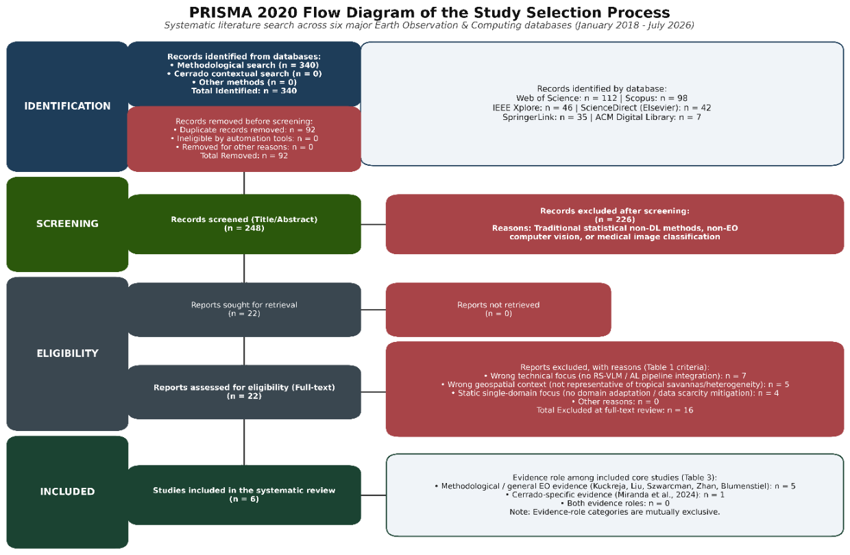
- Quality Assessment: The quality assessment rubric, shown in Table 2, considered four main criteria: methodological clarity, description of the dataset used, reported evaluation metrics, and code reproducibility. The study selection process was documented using a PRISMA 2020 flow diagram (Figure 1), reporting the records identified through the database searches, duplicate removal, title and abstract screening, full-text assessment, exclusions with reasons, and final inclusion of studies in the qualitative synthesis.

Table 1.
Inclusion and Exclusion Criteria.
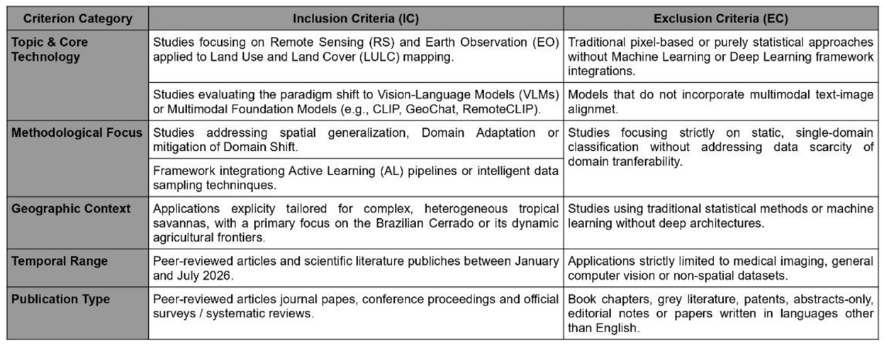 |
Table 2.
Quality Assessment Table – Methodological clarity (Weight 1), Dataset described (Weight 1), Reported metrics (Weight 1), Reproducibility (Weight 1).
Table 2.
Quality Assessment Table – Methodological clarity (Weight 1), Dataset described (Weight 1), Reported metrics (Weight 1), Reproducibility (Weight 1).
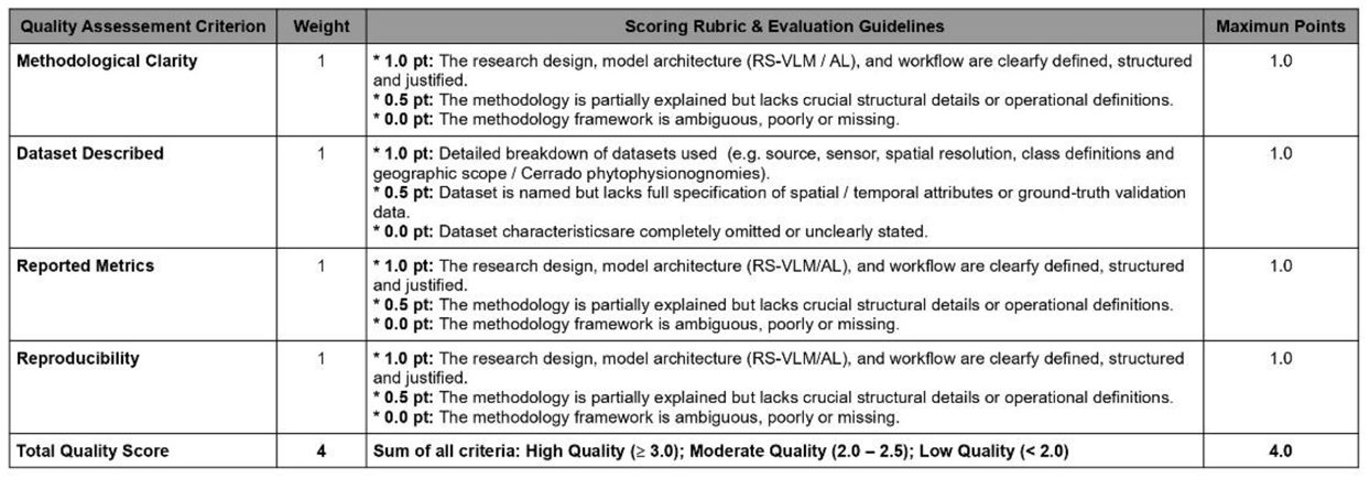 |
Figure 1.
PRISMA 2020 flow diagram illustrating the identification, screening, eligibility, and inclusion process for the systematic literature review. Note: The included studies were distinguished from references used exclusively for background, theoretical foundations, methodological definitions, and contextual characterization of the Brazilian Cerrado. Only studies satisfying the predefined eligibility criteria were considered part of the evidence synthesis and methodological assessment.
This systematic review was not registered in PROSPERO as its scope is strictly focused on environmental remote sensing and artificial intelligence, which falls outside the health-related eligibility criteria of the registry. However, the study strictly follows the PRISMA guidelines.
After being identified and removed, titles and abstracts were screened according to the predefined eligibility criteria. Potentially relevant records were then assessed through full-text review. The screening and eligibility assessment involved three reviewers. All three reviewers contributed to the examination of the identified studies according to the predefined eligibility criteria. The formal methodological quality assessment was conducted by one reviewer, and the study selection and assessment decisions were discussed among the reviewers to resolve potential disagreements by consensus.
Descriptive publication trends derived from the included studies indicate increasing research activity across the methodological approaches examined in this review. The temporal and geographical distribution of the included studies is shown in Figure 2.
2.1. Data Extraction
For each included study, the following information was extracted: publication year, geographic region, sensor/platform, spatial and temporal resolution, LULC task, model architecture, foundation model or RS-VLM, Active Learning strategy, domain-shift type, adaptation strategy, dataset, evaluation metrics, annotation setting, principal findings, and reported limitations. The quality assessment results for the included studies are summarized in Table 3.
2.2. Qualitative Evidence Synthesis
Because the included studies differed substantially in sensors, spatial and temporal resolutions, LULC tasks, datasets, model architectures, Active Learning strategies, domain-shift conditions, and evaluation protocols, statistical pooling of effect estimates was not considered appropriate. Instead, the evidence was synthesized qualitatively through a structured comparative approach.
The included studies were organized according to four principal methodological dimensions: (i) spatial and temporal domain shift; (ii) Active Learning and annotation efficiency; (iii) transferable representations provided by remote-sensing foundation models and RS-VLMs; and (iv) domain adaptation mechanisms. For each dimension, the evidence was compared with respect to the methodological problem addressed, principal strengths, limitations, evaluation setting, and relevance to LULC monitoring under heterogeneous conditions.
The synthesis subsequently examined methodological complementarities across these dimensions and identified evidence gaps that could be translated into testable hypotheses for future empirical investigation. The conceptual framework proposed in this review was therefore derived from the cross-methodological synthesis rather than from a single empirical study or from direct experimental validation in the Brazilian Cerrado.
3. Remote-Sensing Foundation Models and Vision-Language Models: Evidence for Transferable Representations
Artificial Intelligence applied to remote sensing is rapidly migrating from specialist models trained for single, isolated tasks such as U-Net and ResNet variants and YOLO-based architectures [35,36,37], toward large-scale Foundation Models [12,13]. “These models are pre-trained on massive volumes of unlabeled multi-sensor Earth observation data using self-supervised learning techniques, enabling them to learn fundamental spatial, spectral, and temporal invariants across the Earth’s surfaces [14,15].
Remote-Sensing Vision-Language Models (RS-VLMs) may facilitate the field by establishing a direct alignment between visual representations (satellite imagery) and textual modalities (metadata, spatial coordinates, and semantic descriptions) [10,16]. Recent architectures such as GeoChat, TerraMind, SkyEyeGPT and RemoteCLIP have demonstrated capabilities that may facilitate adaptation to novel domains, including multimodal representation learning, few-shot inference, and open-vocabulary or instruction-based interaction [17,18,19,20]. These models leverage transformer-based architectures to perform multiple tasks, like scene classification, visual question answering (VQA) and semantic segmentation, through a unified text-based interface [21,22]. The evolution of remote sensing AI can be interpreted as a gradual transition from purely supervised convolutional models toward foundation models capable of semantic reasoning and efficient adaptation. Table 4 summarizes the main qualitative differences among these paradigms with respect to the challenges addressed in this review.
Conventional CNN- and detector-based architectures, including YOLO-based approaches, have achieved strong task-specific performance in remote-sensing applications but generally depend on supervised annotation [35,36,37]. Such dependence becomes particularly relevant when labeled data are scarce or when models are transferred across geographically distinct environments, motivating complementary approaches based on Active Learning, domain adaptation, and foundation models.
3.1. Remote-Sensing Foundation Models
The paradigm of Artificial Intelligence in remote sensing is rapidly transitioning from specialist models trained on single, isolated tasks—such as task-specific Convolutional Neural Network (CNN) variants and object detectors [1,2,3,4,5], toward large-scale Foundation Models (FMs) [6,7,8]. Pre-trained on massive volumes of unlabeled multi-sensor Earth observation data through self-supervised learning (SSL) techniques [7,9,10,11], fundamental spatial, spectral, and temporal invariants across the Earth’s surface [8,10,12].
From a theoretical perspective, foundation model pre-training leverages pretext objectives—such as masked autoencoding (e.g., SatMAE [7] and Prithvi-EO-2.0 [9]) or contrastive/generative multi-modal learning (e.g., SkySense [10]) to model complex joint probability distributions over multi-spectral and multi-temporal image patches [7,9,10,11]. Downstream adaptation typically operates through two distinct mechanisms: frozen feature extraction, where backbone weights remain fixed to preserve generalized representations while training lightweight task heads, and fine-tuning (either full or parameter-efficient), which adjusts network parameters to domain-specific target distributions [8,9,11,13,14]. This pre-training regime enhances cross-sensor transferability (e.g., transferring feature representations across Sentinel-2, Landsat-8, and high-resolution PlanetScope sensors) and cross-regional generalization across geographically distinct biomes [7,9,15,16,17].
However, the assumption that foundation models inherently generalize better across all Earth observation tasks requires critical examination. Empirically, the transferability of foundation representations is highly context-dependent and varies slightly according to:
- Target Sensing Modality and Resolution: Whether pre-trained representations retain discriminative power when transferred across heterogeneous spatial resolutions (e.g., from 30 m Landsat time series to 3 m PlanetScope or sub-meter aerial imagery) or across distinct spectral configurations (e.g., optical to SAR or hyperspectral data) [2,7,9,16,18].
3.2. Remote-Sensing Vision–Language Models
Remote-Sensing Vision–Language Models (RS-VLMs) represent an extension of multimodal foundation architectures, establishing direct semantic alignment between visual satellite representations and textual modalities (including geographic metadata, spatial coordinates, and domain-specific taxonomies) [6,22,23,24]. Building upon foundational visual-language alignment frameworks such as CLIP [24], recent domain-specific architecture, including RemoteCLIP [23], GeoChat [25], TerraMind [26], SkyEyeGPT [27], EarthGPT [22], LHRS-Bot [28], and MiniGPT-v2 [29] integrate vision transformers with Large Language Models (LLMs) via cross-modal projection layers and instruction tuning [6,22,23,26].
The theoretical strength of RS-VLMs lies in their ability to map visual feature spaces and textual embedding spaces into a shared multimodal manifold [6,22,24]. This visual-semantic alignment enables several key capabilities [6,22,24].
- Semantic Alignment and Prompt-Based Classification: Natural language descriptions act as dynamic, context-aware classifiers (e.g., prompt-based queries such as “Multispectral satellite patch showing dense gallery forest along a stream in the savanna”), allowing models to leverage textual domain knowledge to resolve complex visual patterns [22,23,25].
- Unified Instruction Tuning: By formulating diverse Earth observation tasks—such as scene classification, visual question answering (VQA), change detection, and semantic segmentation—within a unified text-guided instruction framework, RS-VLMs enable interactive, human-in-the-loop reasoning over remote sensing archives [12,25,27,28].
Despite these emergent capabilities, direct empirical evidence validating RS-VLMs for fine-grained land-use and land-cover (LULC) mapping in highly variable tropical savannas remains limited, highlighting the need to integrate these transferable representations with selective target-domain active learning pipelines [6,17,21,23].
3.3. Limitations of Transferability
While foundation models and RS-VLMs demonstrate high capacity in representation benchmarks, claiming unconstrained generalization across Earth observation applications overlooks fundamental domain boundaries [2,4,10]. A rigorous review must reject the oversimplified premise that “foundation models inherently generalize better” [4,6,7]. Instead, transferability must be critically evaluated across eight specific operational dimensions [17,18,19,20].
- Sensing Modality and Sensor Mismatch: Pre-trained representations optimized for standard optical RGB or 10–20 m multispectral bands (e.g., Sentinel-2 [24,25]) do not automatically transfer to SAR backscatter (e.g., Sentinel-1) [3,7] or hyperspectral narrow-band response functions [26,27,28] without explicit cross-modal alignment.
- Class Granularity and Phytophysiognomic Overlap: While foundation models reliably discriminate coarse Level-1 LULC categories (e.g., broad forest vs. Water) [4,10], zero-shot transferability decreases slightly when separating fine-grained, spectrally overlapping vegetation formations (e.g., discriminating Campo Limpo, Cerrado sensu stricto, and degraded pasturelands) [23,32,33].
- Adaptation Regime (Zero-Shot vs. Fine-Tuning): Pure zero-shot inference with RS-VLMs often exhibits sub-optimal calibration compared to supervised baselines in complex biomes [10,11,20]; parameter-efficient fine-tuning (PEFT) or adapter modules are systematically required to achieve operational accuracy thresholds.
- Evaluation Protocols and Spatial Independence: Many transferability studies report validation metrics on spatial partitions drawn from adjacent image tiles, masking severe performance degradation caused by spatial autocorrelation [23,30,34,35]. Valid generalization claims require spatially and temporally independent cross-validation across distinct ecoregions [23,34,35].
Explicitly addressing these transferability boundaries directly reinforces Hypothesis H1 [4,6,7,19]. Rather than assuming universal transferability, H1 posits that foundation models provide transferable visual-semantic priors that reduce, but do not eliminate, target annotation requirements, establishing a formal justification for integrating transferable representations with selective target-domain Active Learning [17,19,20,38].
4. Application Context: Cerrado Environmental Heterogeneity, Domain Shift and MATOPIBA as an Application Context
Monitoring the Cerrado requires complex analytical solutions. Traditional mapping approaches face critical bottlenecks that impede scalability and accuracy across the biome’s vast extent:
- Phenological Variability and Spectral Heterogeneity: The strong alternation between dry and wet seasons drastically alters the spectral behavior of different phytophysiognomies (e.g., Cerrado stricto sensu, Cerradão, Veredas), often causing misclassification between natural grasslands and cultivated pastures [3,23].
- Domain Shift: Spatial differences in soil properties, agricultural practices, vegetation structure, and class distributions may contribute to performance degradation when models are transferred across Cerrado regions. This shift may be driven by variations in soil types, crop management practices, and native landscape structures [7,25].
- Scarcity of Labeled Data: Generating high-resolution semantic annotations for the Cerrado is a time-consuming process that requires specialized human interpreters. Consequently, creating extensive and geographically balanced datasets (such as CerraData-4MM) is prohibitively expensive [26,27]. The spatial heterogeneity of the Cerrado is illustrated in Figure 3.
The MATOPIBA region, comprising areas of Maranhão, Tocantins, Piauí, and Bahia, represents a particularly relevant application context for adaptive LULC monitoring in the Brazilian Cerrado. The region is predominantly covered by Cerrado vegetation and has become an important agricultural frontier, while simultaneously exhibiting substantial environmental, climatic, hydrological, and land-use heterogeneity [1,24]. This combination of rapid land-use conversion and heterogeneous landscape conditions makes MATOPIBA especially relevant for evaluating the spatial transferability of remote-sensing models.
From a methodological perspective, MATOPIBA provides a challenging context in which models trained in one geographic or agricultural setting may encounter substantially different environmental conditions when transferred to another. Changes in vegetation structure, soil properties, agricultural practices, seasonality, and land-cover composition can modify the statistical distribution of the target domain [24]. Consequently, the region is particularly suitable for investigating domain shift, selective annotation, and domain adaptation strategies in LULC mapping. The importance of this context is reinforced by the concentration of recent land-use change and agricultural expansion in the region, which increases the need for spatially and temporally adaptive monitoring systems [1,24].
Accordingly, MATOPIBA is not treated in this review as a separate empirical study domain or as evidence that the proposed framework has already been validated there. Rather, it is considered a high-priority operational context in which the methodological evidence synthesized from multiple geographic settings can be translated into testable hypotheses concerning spatial generalization, annotation efficiency, and domain adaptation for Cerrado LULC monitoring.
4.1. Domain Shift in Remote-Sensing LULC Mapping
Domain shift constitutes a major operational bottleneck in remote-sensing LULC mapping, occurring when a machine learning model trained on a source distribution Psrc(X, Y) encounters a target deployment distribution Ptgt(X, Y) such that Psrc(X, Y) ≠ Ptgt(X, Y) [17,19,40]. In Earth observation, distribution shift can manifest as covariate shift (Psrc(X) ≠ Ptgt(X)), where the distribution of input spectral/spatial features changes; label shift (Psrc(Y) ≠ Ptgt(Y)), where the marginal class proportions differ across landscapes; or concept shift (Psrc(X|Y) ≠ Ptgt(X|Y)), where the underlying relationship between spectral signatures and semantic land-cover classes changes due to environmental or management factors [17,19,40].
A comprehensive breakdown of domain shifts affecting Earth observation workflows—spanning data acquisition, temporal succession, and geographic variability, highlighting the spatial transfer between Cristalina, Goiás and Querência, Mato Grosso is presented in Figure 4 [17,21,22,25,29,34,35,37,40,41,42,43]:
4.2. Domain Adaptation Strategies
To mitigate performance degradation caused by spatial, temporal, and sensor shifts without requiring exhaustive target-domain manual re-annotation, Domain Adaptation (DA) strategies aim to align source and target feature representations [17,19,40]. Modern domain adaptation paradigms in remote sensing encompass several complementary methodological mechanisms [2,17,19,27,45,46].
- Feature Alignment and Discrepancy Minimization: Explicitly reduces statistical divergence between source and target latent distributions by minimizing distance metrics such as Maximum Mean Discrepancy (MMD), Correlation Alignment (CORAL), or Wasserstein distance in intermediate network layers [17,19].
5. Methodological Evidence: Active Learning for Remote Sensing
Active Learning has been investigated as a promising strategy for handling expensive labeling and data scarcity under domain shift scenarios. The core premise of AL is to allow the model to actively select the most informative unlabeled data samples to be annotated by a human expert (the oracle), thereby maximizing performance while minimizing annotation costs [28,29].
The primary AL strategies applicable to remote sensing include:
- Uncertainty Sampling: Selects pixels or image patches where the model has the lowest prediction confidence (e.g., using Shannon entropy) [30].
- Query-by-Committee (QBC): Maintains an ensemble of models and prioritizes the annotation of samples that cause the highest disagreement among the committee members [28].
- Diversity/Cluster-based Sampling: Ensures a spatially and spectrally balanced coverage of the target domain, avoiding redundant sampling in homogeneous areas [31].
The effectiveness of Active Learning in remote sensing has been demonstrated across several application settings. Early studies investigated uncertainty- and diversity-based query strategies for hyperspectral image classification and remote-sensing image retrieval [28,30,31]. Active Learning was subsequently extended to domain adaptation and interactive semantic segmentation [29,32]. More recent studies have investigated deep Active Learning for change detection, multi-label remote-sensing classification, and annotation-efficient fine-tuning of self-supervised models [44,45,46]. Collectively, these studies indicate that Active Learning can reduce annotation requirements and improve the efficiency of sample acquisition, although the magnitude of the benefit depends on the sampling strategy, task, annotation setting, and evaluation protocol.
5.1. Active Learning Strategies and Annotation Efficiency
5.1.1. Uncertainty-Based Sampling
Uncertainty-based sampling is an Active Learning query strategy that selects unlabeled instances where the current model exhibits the lowest prediction confidence, aiming to refine decision boundaries where class ambiguity is highest [18,26,47,48]. The primary mathematical formulations used in remote sensing image classification include [18,38,39,47,48]:
where ŷ1 and ŷ2 are the most probable and second most probable class labels,1 effectively isolating instances near the decision boundary [47,48].
Despite its computational efficiency, pure uncertainty sampling suffers from critical vulnerabilities when applied to deep neural networks in remote sensing [28,36,49]. Deep architectures frequently produce uncalibrated, overconfident probability estimates, particularly under domain shift [36,49]. Furthermore, uncertainty metrics are highly sensitive to unrepresentative outliers, atmospheric noise, shadow artifacts, and mixed pixels along narrow spatial boundaries [18,26,48]. As a result, uncertainty-based sampling can query noisy or redundant samples, leading to poor spatial coverage and inefficient sample acquisition in heterogeneous landscapes [18,36,48].
5.1.2. Diversity and Representativeness
To overcome the boundary-bias and outlier-sensitivity of uncertainty sampling, diversity and representativeness strategies aim to select unlabeled samples that span the target domain’s feature space and reflect its underlying data distribution [18,26,47,48,50].
- Feature-Space and Spatial Diversity: Enforces geometric or distance constraints in the feature space (e.g., pairwise Euclidean or cosine distance between latent representations) or spatial domain, may improve adaptability that queried samples are mutually non-redundant and broadly distributed across the study area [18,27,48].
5.1.3. Query-by-Committee
Query-by-Committee (QBC) is a hypothesis-space active learning paradigm that maintains an ensemble (committee) of classifiers C = {M1, M2,…,MK}, each trained on the current labeled dataset L but representing competing hypotheses within the model’s version space [18,47,48].
The core principle of QBC is to query unlabeled instances where committee members exhibit maximal prediction disagreement, thereby targeting regions of the feature space where model uncertainty is greatest [47,48]. Disagreement among committee posteriors is typically quantified using [38,47,48]:
QBC reduces individual model architecture bias and effectively captures epistemic uncertainty [47,48,50]. However, training and maintaining multiple deep neural networks in an explicit committee is computationally expensive for large-scale satellite image processing [25,50]. To address this, modern deep active learning frameworks utilize implicit ensemble approximationss, such as Monte Carlo Dropout (MC-Dropout) or Monte Carlo Batch Normalization (MCBN), to efficiently estimate model disagreement during inference [25,50].
5.1.4. Hybrid Strategies
A foundational principle in active learning theory is that uncertainty ≠ representativeness [18,47,48,50]. Uncertainty sampling targets instances near decision boundaries where class posteriors are ambiguous (P(Y|X) ≈ 0.5), but ignores whether those instances represent meaningful proportions of the underlying data distribution [47,48]. Conversely, representativeness identifies dense clusters in the feature space (P(X) is high), but ignores model confidence [47,48,50].
In spatially and temporally heterogeneous tropical savannas like the Brazilian Cerrado—characterized by complex mosaics of native phytophysiognomies (Campo Limpo, Cerrado sensu stricto, Cerradão), pastures, and irrigated croplands, pure uncertainty sampling may become inefficient operationally [18,22,25,42]. Because seasonal phenology, fire dynamics, and spectral overlap generate extensive boundary ambiguity, pure uncertainty algorithms continuously query noisy transitional pixels, cloud edges, or local anomalies [18,26,48]. Consequently, annotation budgets may become concentrated on ambiguous or noisy regions, while underrepresented land-cover classes remain insufficiently sampled [18,25,48].
Hybrid strategies resolve this trade-off by explicitly integrating uncertainty and representativeness/diversity into a unified multi-criteria acquisition function [18,26,27,30,39,47,48,50]:
where α ∈ (0, 1) balances sample informativeness against structural coverage [18,39,48]. By querying samples that are both uncertain and representative of target feature distributions, hybrid strategies mitigate boundary-sampling bias and ensure balanced model calibration, directly underpinning Hypothesis H3 [18,26,48,50].
Q(x) = α · Uncertainty(x) + (1 - α) · Representativeness/Diversity(x)
5.1.5. Active Learning Under Domain Shift
Traditional Active Learning literature predominantly assumes an intra-domain setting, where candidate samples are drawn from the same stationary probability distribution as the initial training set (Psrc(X, Y) = Ptgt(X, Y)) [18,47,48]. However, in real-world Earth observation deployments, models encounter severe spatial, temporal, and sensor domain shifts [17,19,40].
Under distribution shift, the fundamental research question shifts from “Does Active Learning reduce label requirements?” to “Does Active Learning reduce target-domain annotations required for reliable model adaptation when transferring across distinct spatial or temporal domains?” [17,19,20,38,50].
Connecting Active Learning directly to domain adaptation shifts the sampling objective toward identifying target-domain instances that characterize distributional mismatches or target-model failure modes [17,19,20,36]. When combined with self-supervised pre-training or transferable model representations, target-domain Active Learning may improve adaptation efficiency by concentrating annotation effort on informative target-domain samples rather than requiring exhaustive manual labeling [19,20,44,45,46]. However, the magnitude of annotation savings varies substantially across tasks, sampling strategies, target domains, and evaluation protocols.
6. Conceptual Translation to Cerrado LULC Monitoring
The proposed framework is not a direct synthesis of Cerrado-specific empirical studies. It is a conceptual translation of methodological evidence obtained across multiple biomes and sensing configurations to the environmental and operational constraints of the Brazilian Cerrado.
LULC mapping in the Cerrado makes spatial generalization a major methodological priority. Based on the literature synthesized in this review, we propose a conceptual framework where the zero-shot and few-shot capabilities of RS-VLMs are dynamically guided by Active Learning pipelines to achieve efficient domain adaptation.
While the VLM provides the capacity to interpret complex semantic prompts (e.g., “Identify degraded pastureland with signs of soil erosion”), the Active Learning module acts as a target-domain information acquisition mechanism, while the subsequent adaptation stage incorporates the newly labeled samples into the model. The AL algorithm evaluates the VLM’s uncertainty across the new geographical target and queries the human user to label only the highly transitional or ambiguous patches that the network failed to resolve (e.g., spectral confusion between sparse native savanna and unmanaged pasture). This synergistic fusion may support the sampling process, ensuring high adaptability in the face of substantial domain shifts.
The proposed framework, shown in Figure 5, is derived from limitations and opportunities consistently identified across the reviewed literature rather than from assumptions specific to the Cerrado alone. First, remote-sensing models trained under geographically or temporally restricted conditions may experience domain shift when acquisition characteristics, land-management practices, vegetation structures, or class distributions differ across domains [29,30]. Second, Active Learning studies demonstrate that uncertainty, diversity and representativeness based sampling can reduce the amount of manually annotated data required for model adaptation [29]. Third, recent remote sensing foundation and vision-language models provide increasingly transferable representations and few-shot or open-vocabulary capabilities [13,15].
These three evidence streams motivate the conceptual integration proposed in this review: foundation-model representations provide a transferable semantic basis, while Active Learning provides a mechanism for selectively acquiring target-domain information where uncertainty, ambiguity or distributional mismatch is highest. Domain adaptation then provides a mechanism for incorporating these target-domain observations into the adapted model.
Importantly, the reviewed literature does not yet provide sufficient evidence to claim that this complete combination has been validated for Cerrado LULC monitoring. The proposed framework should therefore be interpreted as a hypothesis-driven research architecture that integrates complementary mechanisms previously investigated in remote sensing and multimodal learning.
7. Cross-Methodological Evidence Synthesis
The evidence synthesized in this review indicates that annotation scarcity and domain shift should not be treated as isolated problems in remote-sensing LULC mapping. Rather, they represent interacting methodological constraints that affect model transferability, target-domain adaptation, and the efficiency of expert annotation. Active Learning, domain adaptation, remote-sensing foundation models, and Remote-Sensing Vision–Language Models address different components of this broader problem and therefore should be considered complementary rather than mutually exclusive methodological alternatives [17,18,19,20,28,29,30,31,32,44,45,46,47,48,49,50].
The conceptual distinction among these approaches is important for interpreting the evidence. Active Learning primarily addresses the information-acquisition problem, determining which unlabeled target-domain samples are most informative for subsequent annotation [28,29,30,31,32,44,45,46,47]. Domain adaptation addresses the distribution-alignment problem, seeking to mitigate the performance degradation associated with differences between source and target domains [17,19,40]. Foundation models and RS-VLMs address the representation-transfer problem, providing pretrained visual or multimodal representations that may reduce dependence on task-specific labeled data [12,13,14,15,16,17,18,19,20]. The resulting methodological complementarity provides the basis for the framework and research hypotheses proposed in this review.
7.1. Comparative Methodological Synthesis
The reviewed approaches differ substantially in their primary objective, evidence maturity, operational advantages, and limitations. Conventional supervised learning remains an important baseline because it provides a direct reference for evaluating transferability and annotation efficiency, but its dependence on task-specific labeled data becomes increasingly restrictive when models are deployed across geographically or temporally distinct environments [5,6,41]. Domain adaptation provides mechanisms for incorporating source and target distributions under distributional mismatch, including feature alignment, adversarial adaptation, pseudo-labeling, fine-tuning, and related strategies [17,19,40]. Active Learning complements these approaches by selectively acquiring target-domain labels rather than relying on exhaustive annotation [28,29,30,31,32,44,45,46,47].
Foundation models extend the transferability paradigm by learning representations from large-scale Earth observation data, while RS-VLMs further introduce multimodal alignment between visual information and semantic or textual representations [12,13,14,15,16,17,18,19,20]. Recent models such as GeoChat, TerraMind, SkyEyeGPT, RemoteCLIP, EarthGPT, and related architectures demonstrate increasingly broad multimodal capabilities, including few-shot, open-vocabulary, instruction-based, or multisensor interpretation [16,17,18,19,20,21,22]. Nevertheless, the evidence also indicates that transferability is conditional on sensing modality, spatial resolution, task formulation, class granularity, geographic context, and evaluation protocol. Consequently, pretrained representations should not be interpreted as guaranteeing unrestricted cross-domain generalization [2,4,10,17,18,19,20].
Table 6 summarizes the methodological roles of the principal approaches considered in this review, emphasizing the specific problem addressed by each paradigm, its principal strength, its main limitation, and its relevance to adaptive LULC monitoring in the Cerrado.
The comparison highlights that the approaches occupy different positions within the adaptation process. Active Learning determines which target information should be acquired; domain adaptation determines how source and target distributions can be reconciled; and foundation models or RS-VLMs determine which transferable representations can be used as the starting point for that adaptation [12,13,14,15,16,17,18,19,20,28,29,30,31,32,44,45,46,47,48,49,50]. This distinction is central to the interpretation of the evidence because it prevents the methodological paradigms from being treated as competing solutions to the same problem.
7.2. Evidence for Annotation Efficiency and Domain Adaptation
The evidence concerning Active Learning consistently supports its potential to improve the efficiency of sample acquisition in remote-sensing applications. Early studies investigated uncertainty-, diversity-, and committee-based strategies for hyperspectral classification and image retrieval, establishing the methodological basis for selecting informative samples rather than randomly annotating the available data [28,29,30,31]. Subsequent work extended Active Learning to domain adaptation, interactive semantic segmentation, change detection, multi-label classification, and annotation-efficient fine-tuning of self-supervised representations [29,32,44,45,46,47]. These studies collectively indicate that the value of Active Learning depends not only on the query strategy itself but also on the task, target-domain characteristics, annotation protocol, and evaluation design.
Uncertainty-based sampling is particularly attractive because it concentrates annotation on samples associated with ambiguous predictions. However, the reviewed evidence also identifies important limitations under heterogeneous remote-sensing conditions. Uncertainty estimates may be affected by model calibration, atmospheric effects, mixed pixels, shadows, spatial boundaries, and unrepresentative outliers, potentially producing redundant or noisy queries [18,26,36,47,48,49,50]. Diversity and representativeness criteria address a complementary objective by encouraging coverage of the target feature distribution and reducing redundant sampling [18,26,47,48]. Hybrid strategies consequently provide a theoretically motivated mechanism for combining informativeness with coverage, which directly supports Hypothesis H3.
The relevance of this distinction becomes greater under domain shift. When the target domain differs systematically from the source domain, the objective of Active Learning is no longer limited to improving a model within a stationary distribution. Instead, the selected samples should provide information about target-domain characteristics, model failure modes, and regions where the source-trained representation is insufficient [17,19,20]. Domain adaptation and Active Learning can therefore be viewed as complementary stages: domain adaptation provides mechanisms for accommodating distributional mismatch, while Active Learning determines which target-domain observations should receive scarce expert annotation [17,19,20,44,45,46,47].
The reviewed literature further suggests that transferable representations can modify this relationship. Foundation models and RS-VLMs may provide a more informative initialization for target-domain adaptation, potentially reducing the dependence on task-specific training from scratch [12,13,14,15,16,17,18,19,20]. However, the evidence does not justify assuming that pretrained representations will consistently reduce annotation requirements across all LULC tasks or geographic conditions. Transferability remains dependent on the similarity between pretraining and deployment conditions, sensor characteristics, spatial resolution, class definitions, and task formulation [2,4,10,17,18,19,20]. Accordingly, the appropriate empirical question is not whether foundation models universally eliminate the need for annotation, but whether they can reduce the amount of target-domain information required to reach a predefined performance level under controlled cross-domain evaluation.
This distinction directly motivates Hypotheses H1 and H2 and, more importantly, provides the methodological rationale for H4. If transferable representations improve the initial representation of the target domain, while Active Learning selectively identifies the most informative target samples, their combination may provide a more annotation-efficient adaptation pathway than either component used independently. At present, however, the reviewed literature provides insufficient direct evidence to establish this integrated effect as an empirical fact. It should therefore be treated as a testable proposition rather than a demonstrated outcome.
7.3. Methodological Complementarity and Hypothesis Mapping
The central synthesis emerging from the reviewed evidence is that the three methodological dimensions considered in this review address complementary stages of an adaptive LULC mapping process. Foundation models and RS-VLMs provide transferable representations that may establish a useful initialization across domains; Active Learning provides a mechanism for selectively acquiring target-domain information; and domain adaptation provides mechanisms for incorporating that information while accounting for distributional mismatch [12,13,14,15,16,17,18,19,20,28,29,30,31,32,44,45,46,47].
This complementarity is particularly relevant when the target landscape is spatially and temporally heterogeneous. In such settings, a model may encounter differences in vegetation structure, phenology, agricultural practices, sensor characteristics, spatial resolution, and class distributions. These differences can alter both the visual representation of land-cover classes and the relative frequency of classes in the target domain [17,19,23,24,25]. A robust adaptive system should therefore be evaluated not only according to overall predictive accuracy, but also according to its ability to maintain performance across spatially separated regions, temporal conditions, and heterogeneous LULC classes.
The hypotheses proposed in the Introduction translate this methodological complementary into specific empirical propositions. H1 concerns whether transferable foundation-model or RS-VLM representations improve cross-domain generalization relative to task-specific supervised representations. H2 concerns whether Active Learning reduces the target-domain annotation required to reach a predefined performance level. H3 addresses whether combining uncertainty with diversity or representativeness improves annotation efficiency under spatial domain shift. H4 addresses the interaction between transferable representations and selective target-domain annotation. H5 recognizes that the magnitude of these effects may vary across LULC classes and environmental contexts within the Cerrado.
The relationship between these hypotheses and the corresponding evidence base is summarized in Table 7. Importantly, the table does not represent empirical confirmation of the hypotheses. Instead, it identifies the methodological evidence that motivates each proposition and specifies the type of empirical evaluation required to test it.
The resulting framework can therefore be understood as a sequence of complementary methodological functions rather than as a claim that any single model architecture is sufficient. A transferable representation can provide the initial feature space; target-domain inference can identify uncertainty, diversity, and representativeness patterns; expert annotation can then be concentrated on selected samples; and the resulting information can be incorporated through an appropriate adaptation or fine-tuning mechanism [17,18,19,20,28,29,30,31,32,44,45,46,47]. The resulting system remains subject to evaluation under independent spatial and temporal conditions, particularly because apparent transferability can be inflated when training and validation samples are spatially correlated [17,23,34,35].
This synthesis also clarifies the specific contribution of the present review. The contribution is not the empirical demonstration of a new integrated algorithm, nor the claim that RS-VLMs have already solved domain-adaptive Cerrado LULC mapping. Rather, the contribution lies in organizing evidence from methodological streams that have generally been investigated separately and translating their complementarity into a coherent, testable research architecture for annotation-efficient monitoring.
7.4. Evidence Gaps
The cross-methodological synthesis identifies several unresolved issues that currently limit the translation of these approaches into operational Cerrado LULC monitoring.
- Gap 1: Multimodal and Benchmarking Infrastructure: The availability of standardized multimodal benchmarks remains important for evaluating whether visual-language representations transfer effectively to geographically diverse LULC conditions. In the Cerrado, benchmark resources should represent relevant land-cover classes and phytophysiognomies and, where possible, combine Earth observation imagery with semantic descriptions that support multimodal evaluation [27]. Such resources would provide a common basis for comparing zero-shot, few-shot, fine-tuning, and transfer-learning strategies under controlled spatial conditions.
- Gap 2: Standardized Active Learning Evaluation: Although Active Learning has been investigated across remote-sensing classification, segmentation, change detection, and related tasks [28,29,30,31,32,44,45,46,47], the reviewed studies differ in acquisition strategies, annotation budgets, evaluation protocols, and spatial validation schemes. This heterogeneity limits direct comparison of annotation efficiency. Future benchmarks should therefore report performance as a function of annotation budget and evaluate sequential acquisition under spatially and temporally separated target domains.
- Gap 3: Explainability and Expert Verification: The increasing use of multimodal models introduces a need for transparent interpretation of model outputs in environmental applications. Explainable representations, visual grounding, and traceable multimodal predictions may facilitate expert verification and improve the practical interpretability of model-assisted LULC mapping [33]. This issue becomes particularly important when model outputs are incorporated into operational monitoring workflows in which expert judgment remains part of the decision process.
- Gap 4: Cross-Domain and Cross-Temporal Adaptation: The reviewed evidence demonstrates the importance of domain adaptation when geographic, environmental, acquisition, or temporal conditions differ between source and target domains [17,19,40]. However, simultaneous spatial and temporal shifts remain insufficiently characterized for operational LULC monitoring. Future evaluations should therefore combine geographically separated domains with contrasting temporal conditions and explicitly assess changes in class distributions and potential degradation of previously acquired representations.
- Gap 5: Human-in-the-Loop Continuous Adaptation: The integration of selective expert annotation with continuously updated models remains insufficiently standardized for operational remote-sensing monitoring. Human-in-the-loop strategies offer a potential mechanism for prioritizing uncertain, representative, or domain-specific samples for expert verification and subsequently incorporating those observations into iterative model adaptation [32,34,44,45,46,47]. The principal unresolved issue is therefore how to define reliable interaction protocols between model uncertainty, sampling decisions, expert annotation, and model updating.
- Gap 6: Integration of Transferable Representations and Selective Target-Domain Annotation: The strongest unresolved methodological gap concerns the direct integration of transferable representations, Active Learning, and domain adaptation. The reviewed literature provides evidence for each component individually and for selected pairwise relationships, but direct empirical evaluation of their combined use under spatially and temporally heterogeneous LULC conditions remains limited [17,18,19,20,44,45,46,47]. In particular, few studies systematically determine whether transferable foundation-model or RS-VLM representations reduce the amount of target-domain annotation required for reliable adaptation. This gap provides the immediate empirical rationale for H4 and for the conceptual framework proposed in this review.
Taken together, these gaps indicate that the next methodological step is not simply the development of increasingly large models, but the controlled evaluation of representation transfer, selective information acquisition, and domain adaptation as interacting components of an adaptive monitoring system. Such evaluation should prioritize spatially independent validation, cross-temporal testing, explicit annotation budgets, class-wise performance, strong task-specific baselines, and ablation of individual methodological components. This design would make it possible to distinguish genuine gains in transferability and annotation efficiency from gains attributable to data leakage, spatial autocorrelation, weak baselines, or differences in evaluation protocol.
The evidence synthesized here therefore supports a cautious but consequential conclusion: the methodological value of foundation models, RS-VLMs, Active Learning, and domain adaptation may lie less in their isolated application than in their potential to form a coordinated adaptation pipeline. For the Brazilian Cerrado, this proposition is particularly relevant because the environmental and land-use heterogeneity described earlier provides a realistic stress-test context for evaluating whether such coordination can produce robust cross-spatial and cross-temporal LULC monitoring. The framework proposed in this study should consequently be interpreted as a hypothesis-driven research architecture derived from the reviewed evidence, not as an experimentally validated Cerrado-specific system.
8. Conclusions
This review synthesized methodological evidence on Active Learning, domain adaptation, remote-sensing foundation models, and Remote-Sensing Vision–Language Models for LULC mapping under annotation scarcity and spatial or temporal domain shift. The evidence indicates that these approaches address complementary aspects of the adaptation problem: transferable representations can support cross-domain generalization, Active Learning can reduce the need for exhaustive target-domain annotation, and domain adaptation can incorporate target-domain information under distributional mismatch.
For the Brazilian Cerrado, these complementary mechanisms are particularly relevant because seasonal phenology, spectral overlap, fire dynamics, heterogeneous agricultural practices, and uneven land-cover distributions may generate substantial spatial and temporal domain shifts. The review therefore proposes a conceptual human-in-the-loop architecture in which transferable representations are combined with selective target-domain annotation and subsequent adaptation.
The proposed architecture is not presented as an experimentally validated system. Rather, it constitutes a hypothesis-driven framework derived from the synthesis of existing evidence and is intended to guide future empirical evaluation. The principal research challenge identified by this review is therefore not the isolated use of Active Learning, domain adaptation, or foundation models, but the systematic evaluation of their interaction under realistic cross-spatial and cross-temporal conditions.
Future studies should test the proposed hypotheses using controlled annotation budgets, spatially separated training and test domains, cross-temporal evaluation, class-wise performance analysis, and ablation experiments comparing individual and integrated methodological components. Such evaluations would provide the empirical basis required to determine whether transferable representations combined with selective target-domain annotation can deliver more scalable and robust Cerrado LULC monitoring.
Author Contributions
Conceptualization, D.S. and E.B.; methodology, D.S. and L.W.; investigation, D.S., E.B., L.W., and P.B.; writing—original draft preparation, D.S.; writing—review and editing, D.S., E.B., L.W., and P.B.; supervision, E.B., L.W., and H.R.
Funding
This research was funded by the Conselho Nacional de Desenvolvimento Científico e Tecnológico (CNPq), Brazil, through a doctoral scholarship granted to (Daniel de Oliveira Soares) D.O.S. (grant number 141928/2025-5).
Conflicts of Interest
The authors declare no conflicts of interest.
References
- Colman, C.B.; et al. Modeling the Brazilian Cerrado land use change highlights the need to account for private property sizes for biodiversity conservation. Sci. Rep. 2024, 14. [Google Scholar] [CrossRef] [PubMed]
- Brannstrom, C.; Jepson, W.; Filippi, A.M.; Redo, D.; Xu, Z.; Ganesh, S. Land change in the Brazilian Savanna (Cerrado), 1986–2002: comparative analysis and implications for land-use policy. Land Use Policy 2008, 25, 579–595. [Google Scholar] [CrossRef]
- Sano, E.E.; Rosa, R.; Brito, J.L.S.; Ferreira, L. Land cover mapping of the tropical savanna region in Brazil. Environ. Monit. Assess. 2010, 166, 113–124. [Google Scholar] [CrossRef] [PubMed]
- Fushimi, M.; Lima, G.N.; Capoane, V. Changes in Land Use and Cover and Their Environmental Impacts in the Cerrado of Mato Grosso Do Sul, Brazil. Sustainability 2024, 16, 4266. [Google Scholar] [CrossRef]
- Ma, L.; Liu, Y.; Zhang, X.; Ye, Y.; Yin, G.; Johnson, B.A. Deep learning in remote sensing applications: A meta-analysis and review. ISPRS J. Photogramm. Remote Sens. 2019, 152, 166–177. [Google Scholar] [CrossRef]
- Fonseca, L.M.G.; Körting, T.S.; Bendini, H.N.; Girolamo-Neto, C.D.; Neves, A.K.; Soares, A.R.; Taquary, E.C.; Maretto, R.V. Pattern Recognition and Remote Sensing techniques applied to Land Use and Land Cover mapping in the Brazilian Savannah. Pattern Recognit. Lett. 2021, 148, 54–60. [Google Scholar] [CrossRef]
- Tuia, D.; Persello, C.; Bruzzone, L. Recent advances in domain adaptation for the classification of remote sensing data. IEEE Geosci. Remote Sens. Mag. 2016, 4, 41–57. [Google Scholar] [CrossRef]
- Matosak, B.M.; Fonseca, L.M.G.; Taquary, E.C.; Maretto, R.V.; Bendini, H.N.; Adami, M. Mapping Deforestation in Cerrado Based on Hybrid Deep Learning Architecture and Medium Spatial Resolution Satellite Time Series. Remote Sens. 2022, 14, 209. [Google Scholar] [CrossRef]
- Adarme, M.O.; Feitosa, R.Q.; Happ, P.N.; Almeida, C.A.D.; Gomes, A.R. Evaluation of Deep Learning Techniques for Deforestation Detection in the Brazilian Amazon and Cerrado Biomes From Remote Sensing Imagery. Remote Sens. 2020, 12, 910. [Google Scholar] [CrossRef]
- Zhou, Y.; Feng, L.; Ke, Y.; Jiang, X.; Yan, J.; Yang, X.; Zhang, W. Towards Vision-Language Geo-Foundation Models: A Survey. arXiv 2024, arXiv:2406.09385. [Google Scholar]
- Zhu, X.X.; Tuia, D.; Mou, L.; Xia, G.-S.; Zhang, L.; Xu, F.; Fraundorfer, F. Deep Learning in Remote Sensing: A Comprehensive Review and List of Resources. IEEE Geosci. Remote Sens. Mag. 2017, 5, 8–36. [Google Scholar] [CrossRef]
- Cong, M.; et al. SatMAE: Pre-training Transformers for Temporal and Multispectral Satellite Imagery. Adv. Neural Inf. Process. Syst. 2022. [Google Scholar] [CrossRef]
- Wang, D.; Zhang, Q.; Xu, Y.; Zhang, J.; Du, B.; Tao, D.; Zhang, L. Advancing plain vision transformer toward remote sensing foundation model. IEEE Trans. Geosci. Remote Sens. 2022, 61, 1–15. [Google Scholar] [CrossRef]
- Szwarcman, D.; et al. Prithvi-EO-2.0: A Versatile Multi-Temporal Foundation Model for Earth Observation Applications. arXiv 2024, arXiv:2404.08322. [Google Scholar]
- Guo, X.; et al. SkySense: A Multi-Modal Remote Sensing Foundation Model Towards Universal Interpretation for Earth Observation Imagery. arXiv 2023, arXiv:2312.10115. [Google Scholar]
- Zhang, W.; Cai, M.; Zhang, T.; Zhuang, Y.; Mao, X. EarthGPT: A Universal Multimodal Large Language Model for Multisensor Image Comprehension in Remote Sensing Domain. IEEE Trans. Geosci. Remote Sens. 2024, 62, 1–20. [Google Scholar] [CrossRef]
- Kuckreja, K.; Danish, M.S.; Naseer, M.; Das, A.; Khan, S.; Khan, F.S. GeoChat: Grounded Large Vision-Language Model for Remote Sensing. Proc. of the IEEE/CVF Conf. Comput. Vis. Pattern Recognit. (CVPR), 2024; pp. 27831–27840. [Google Scholar]
- Blumenstiel, B.; et al. TerraMind: Large-Scale Generative Multimodality for Earth Observation. arXiv 2025, arXiv:2503.15969. [Google Scholar]
- Zhan, Y.; Xiong, Z.; Yuan, Y. SkyEyeGPT: Unifying remote sensing vision-language tasks via instruction tuning with large language model. ISPRS J. Photogramm. Remote Sens. 2025, 221, 64–77. [Google Scholar] [CrossRef]
- Liu, F.; Chen, D.; Guan, Z.; Zhou, X.; Zhu, J.; Zhou, J. RemoteCLIP: A Vision Language Foundation Model for Remote Sensing. In IEEE Trans. Geosci. Remote Sens.; 2024. [Google Scholar]
- Muhtar, D.; Li, Z.; Gu, F.; Zhang, X.; Xiao, P. LHRS-Bot: Empowering remote sensing with VGI-enhanced large multimodal language model. arXiv 2024, arXiv:2402.02544. [Google Scholar]
- Chen, J.; Zhu, D.; Shen, X.; Li, X.; Liu, Z.; Zhang, P.; Krishnamoorthi, R.; Chandra, V.; Xiong, Y.; Elhoseiny, M. MiniGPT-v2: Large language model as a unified interface for vision-language multi-task learning. arXiv 2023, arXiv:2310.09478. [Google Scholar]
- Beuchle, R.; Grecchi, R.C.; Shimabukuro, Y.E.; Seliger, R.; Eva, H.D.; Sano, E.; Achard, F. Land cover changes in the Brazilian Cerrado and Caatinga biomes from 1990 to 2010 based on a systematic remote sensing sampling approach. Appl. Geogr. 2015, 58, 116–127. [Google Scholar] [CrossRef]
- Grecchi, R.C.; Gwyn, Q.H.J.; Bénié, G.B.; Formaggio, A.R. Land-use and land-cover changes in the Brazilian Cerrado. Appl. Geogr. 2014, 55, 311–322. [Google Scholar]
- Alencar, A.; Shimbo, J.Z.; Lenti, F.; Marques, C.B.; Zimbres, B.; Rosa, M.; et al. Mapping Three Decades of Changes in the Brazilian Savanna Native Vegetation Using Landsat Data Processed in the Google Earth Engine Platform. Remote Sens. 2020, 12, 924. [Google Scholar] [CrossRef]
- Miranda, M.S.; Santiago Júnior, V.A.; Körting, T.S.; Monteiro, E.C.S.; Silva, J.Q. AI4LUC: deep learning and automated mask labelling to support land use and land cover mapping in the Cerrado biome. Remote Sens. Lett. 2024, 15, 850–860. [Google Scholar] [CrossRef]
- Miranda, M.S.; Hänsch, R.; Santiago Júnior, V.A.; Körting, T.S.; Monteiro, E.C.S. CerraData-4MM: A multimodal benchmark dataset on Cerrado for land use and land cover classification. ArXiv 2024. [Google Scholar]
- Demir, B.; Bruzzone, L. A novel active learning method in relevance feedback for content-based remote sensing image retrieval. IEEE Trans. Geosci. Remote Sens. 2015, 53, 2323–2334. [Google Scholar] [CrossRef]
- Persello, C.; Bruzzone, L. Active learning for domain adaptation in the supervised classification of remote sensing images. IEEE Trans. Geosci. Remote Sens. 2012, 50, 4468–4483. [Google Scholar] [CrossRef]
- Zhang, Z.; Crawford, M.M. An Active Learning Framework for Hyperspectral Image Classification Using Hierarchical Segmentation. IEEE J. Sel. Top. Appl. Earth Obs. Remote Sens. 2015, 7, 491–501. [Google Scholar]
- Di, W.; Crawford, M.M. Active learning via multi-view and local proximity co-regularization for hyperspectral image classification. IEEE J. Sel. Top. Appl. Earth Obs. Remote Sens. 2011, 5, 618–628. [Google Scholar] [CrossRef]
- Lenczner, G.; Chan-Hon-Tong, A.; Saux, B.L.; Luminari, N.; Besnerais, G.L. DIAL: Deep interactive and active learning for semantic segmentation in remote sensing. IEEE J. Sel. Top. Appl. Earth Obs. Remote Sens. 2022, 15, 3376–3389. [Google Scholar] [CrossRef]
- Liu, P.; Wang, L.; Li, J. Unlocking the Potential of Explainable Artificial Intelligence in Remote Sensing Big Data. Remote Sens. MDPI 2023, v. 15(n. 23), 5448. [Google Scholar] [CrossRef]
- Raiyani, K.; Gonçalves, T.; Rato, L. Abbreviating Labelling Cost for Sentinel-2 Image Scene Classification Through Active Learning. In Iberian Conference on Pattern Recognition and Image Analysis; Springer: Cham, Switzerland, 2022; pp. 295–308. [Google Scholar]
- Redmon, J.; Divvala, S.; Girshick, R.; Farhadi, A. You Only Look Once: Unified, Real-Time Object Detection. In Proceedings of the IEEE Conference on Computer Vision and Pattern Recognition (CVPR), 2016; pp. 779–788. [Google Scholar]
- Redmon, J.; Farhadi, A. YOLO9000: Better, Faster, Stronger. In Proceedings of the IEEE Conference on Computer Vision and Pattern Recognition (CVPR), 2017; pp. 7263–7271. [Google Scholar]
- Redmon, J.; Farhadi, A. YOLOv3: An Incremental Improvement. arXiv 2018, arXiv:1804.02767. [Google Scholar]
- Radford, A.; Kim, J.W.; Hallacy, C.; Ramesh, A.; Goh, G.; Agarwal, S.; Sastry, G.; Askell, A.; Mishkin, P.; Clark, J.; et al. Learning Transferable Visual Models From Natural Language Supervision. Proc. Int. Conf. Mach. Learn. (ICML), 2021; PMLR; pp. 8748–8763. [Google Scholar]
- Settles, B. Active Learning Literature Survey; Computer Sciences Technical Report 1648; University of Wisconsin-Madison: Madison, WI, USA, 2009. [Google Scholar]
- Tuia, D.; Volpi, M.; Copa, L.; Kanevski, M.; Muñoz-Marí, J. A survey of active learning algorithms for supervised remote sensing image classification. IEEE J. Sel. Top. Signal Process. 2011, 5, 606–617. [Google Scholar] [CrossRef]
- Zhao, S.; Tu, K.; Ye, S.; Tang, H.; Hu, Y.; Xie, C. Land Use and Land Cover Classification Meets Deep Learning: A Review. Sensors 2023, 23, 8966. [Google Scholar] [CrossRef] [PubMed]
- Liu, P.; Zhang, H.; Eom, K.B. Active Deep Learning for Classification of Hyperspectral Images. IEEE J. Sel. Top. Appl. Earth Obs. Remote Sens. 2016, 10, 712–724. [Google Scholar] [CrossRef]
- Xie, G.; Liu, P.; Chen, Z.; Chen, L.; Ma, Y.; Zhao, L. Time Series Remote Sensing Image Classification with a Data-Driven Active Deep Learning Approach. Remote Sens. 2024, 16, 1509. [Google Scholar]
- Růžička, V.; D’Aronco, S.; Wegner, J.D.; Schindler, K. Deep Active Learning in Remote Sensing for data efficient Change Detection. arXiv 2020, arXiv:2008.11201. [Google Scholar]
- Möllenbrok, L.; Sumbul, G.; Demir, B. Deep Active Learning for Multi-Label Classification of Remote Sensing Images. IEEE Geosci. Remote Sens. Lett. 2023, 20, 1–5. [Google Scholar] [CrossRef]
- Möllenbrok, L.; Demir, B. Active Learning Guided Fine-Tuning for Enhancing Self-Supervised based Multi-Label Classification of Remote Sensing Images. In Proc. IEEE Int. Geosci. Remote Sens. Symp. (IGARSS); IEEE, 2023; pp. 1–4. [Google Scholar]
- Wang, Z.; Zhang, J.; Bai, L.; Chang, H.; Chen, Y.; Zhang, Y.; Tao, J. A Deep Learning Based Platform for Remote Sensing Images Change Detection Integrating Crowdsourcing and Active Learning. Sensors 2024, 24, 1509. [Google Scholar] [CrossRef] [PubMed]
- Goodfellow, I.; Bengio, Y.; Courville, A. Deep Learning; MIT Press: Cambridge, MA, USA, 2016. [Google Scholar]
- Zhang, Z.; Vosselman, G.; Gerke, M.; Tuia, D.; Yang, M.Y. Change detection between multimodal remote sensing data using siamese CNN. arXiv 2018, arXiv:1807.09562. [Google Scholar]
- Qu, Z.; et al. Deep active learning for remote sensing object detection. In IEEE Int. Conf. Image Process. (ICIP); IEEE, 2020; pp. 1120–1124. [Google Scholar]
- Tuia, D.; et al. Towards a Collective Agenda on AI for Earth Science Data Analysis. IEEE Geosci. Remote Sens. Mag. 2021, 9, 88–104. [Google Scholar] [CrossRef]
- Liu, P.; Wang, L.; Ranjan, R.; He, G.; Zhao, L. A survey on active deep learning: From model-driven to data-driven. ACM Comput. Surv. 2022, 54, 1–34. [Google Scholar]
Figure 2.
Temporal and Geographical Distribution of the Included Studies.
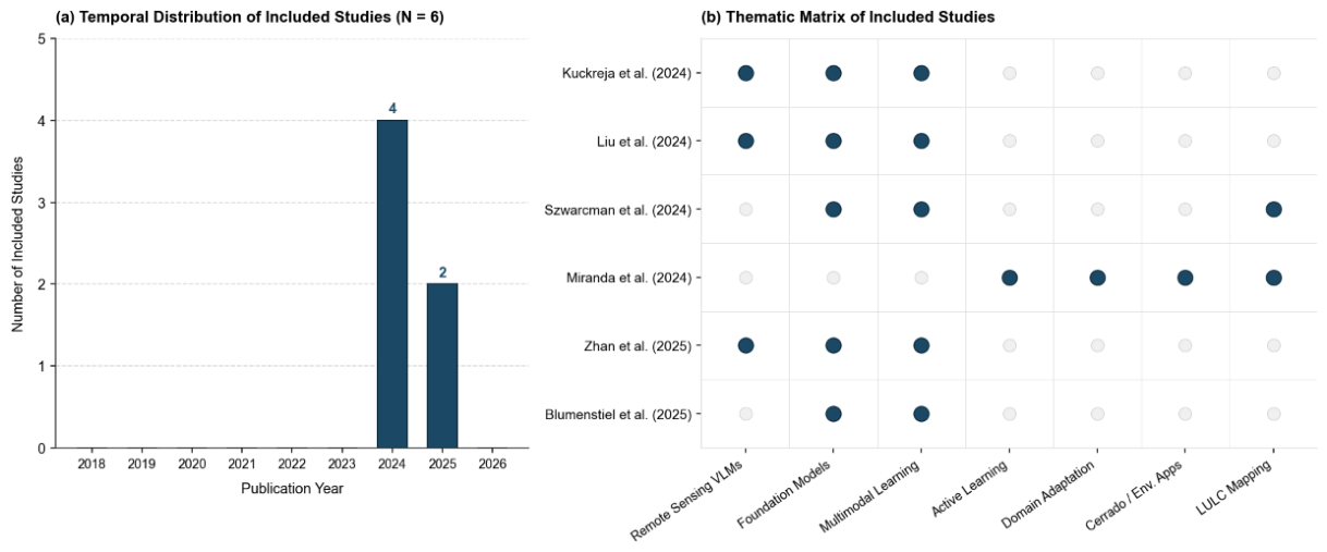
Figure 3.
Brazilian Cerrado biome phytophysiognomies and LULC in the selected municipalities.
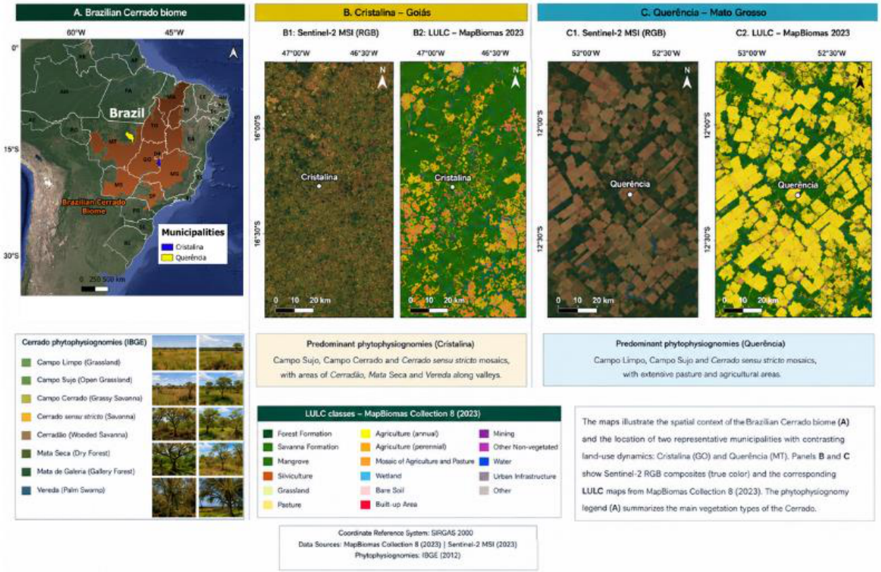
Figure 4.
Conceptual taxonomy of domain shift types in remote sensing land use and land cover (LULC) mapping, structured across data acquisition, temporal/structural, and geographic/environmental axes. Spatial shift highlights cross-region generalization challenges between distinct agricultural and native frontiers, exemplified by Cristalina, Goiás and Querência, Mato Grosso.
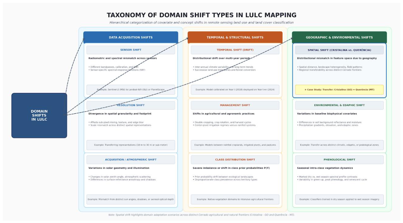
Figure 5.
Conceptual human-in-the-loop framework for domain-adaptive Cerrado LULC monitoring. The architecture combines transferable representations from remote-sensing foundation models or RS-VLMs, target-domain uncertainty and diversity estimation, selective expert annotation, domain adaptation, and cross-spatial and cross-temporal evaluation. The framework is conceptual and requires empirical validation.
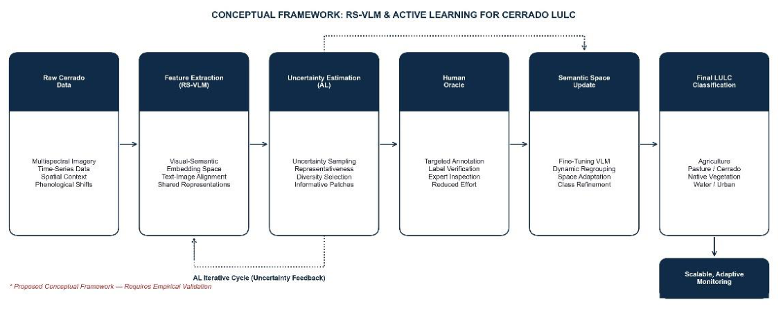
Table 3.
Quality Assessment Matrix.
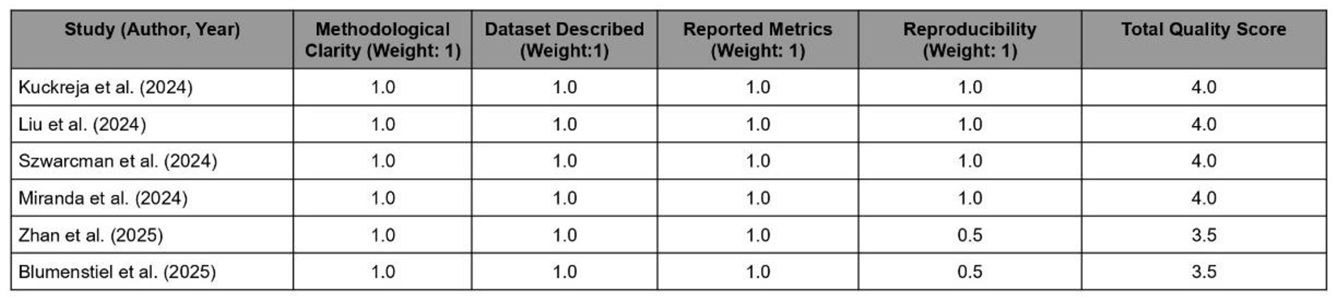 |
Table 4.
Comparative characteristics of representative remote-sensing foundation and vision-language models.
Table 4.
Comparative characteristics of representative remote-sensing foundation and vision-language models.
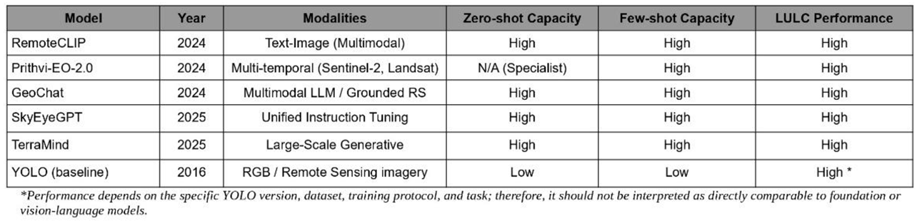 |
Table 5.
Active Learning Strategies – Containing: Strategy, Advantage, Limitation.
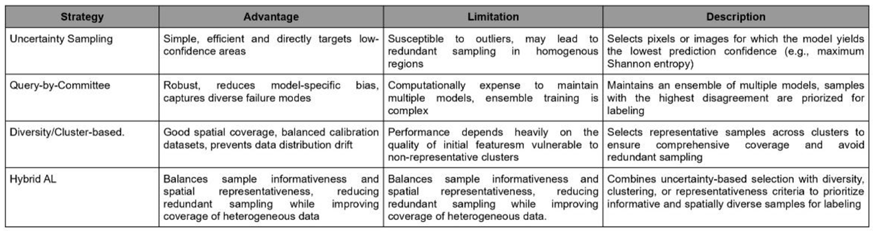 |
Table 6.
Comparative methodological synthesis of the reviewed approaches.
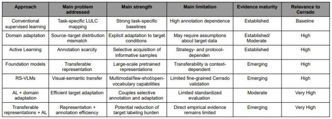 |
Table 7.
Mapping of reviewed evidence to the proposed hypotheses.
 |
Disclaimer/Publisher’s Note: The statements, opinions and data contained in all publications are solely those of the individual author(s) and contributor(s) and not of MDPI and/or the editor(s). MDPI and/or the editor(s) disclaim responsibility for any injury to people or property resulting from any ideas, methods, instructions or products referred to in the content. |
© 2026 by the authors. Licensee MDPI, Basel, Switzerland. This article is an open access article distributed under the terms and conditions of the Creative Commons Attribution (CC BY) license (http://creativecommons.org/licenses/by/4.0/).
Copyright: This open access article is published under a Creative Commons CC BY 4.0 license, which permit the free download, distribution, and reuse, provided that the author and preprint are cited in any reuse.