

Submitted:
11 September 2026
Posted:
14 September 2026
You are already at the latest version
Abstract
Recurrent landscape fires may threaten biodiversity in small protected areas embedded within human-dominated landscapes. We assessed fire occurrence and its spatial coincidence with species of conservation concern in protected natural area “Lalinačka Slatina”, by integrating stakeholder surveys, NASA FIRMS active-fire records, hydrometeorological data, and field-based mapping of selected plant and bird features. Stakeholders identified 48 fire-associated locations in the past decade, over 93% of which were linked to agricultural land or waste-disposal sites. The FIRMS dataset contained 1,073 active-fire detections, while 80% of MODIS detections recorded during 2001–2025 occurred between July and October. Maximum monthly temperature was positively associated with fire activity (IRR = 1.071, p = 0.0015), whereas precipitation had a negative effect (IRR = 0.957, p < 0.001). Direct correspondence between stakeholder-derived polygons and FIRMS detections was limited, indicating that the two sources captured complementary aspects of local fire occurrence. Fire exposure of selected species was spatially heterogeneous, reaching 98.8% in one mapped bird area and 100%, 96.5%, and 66.6% in several plant subpopulations. These results identify specific conservation-important areas where recurrent fire exposure is concentrated and provide a basis for targeted prevention, surveillance, and future ecological monitoring.
Keywords:
inland salt marsh
; wildfire
; protected area
; fire exposure
; remote sensing
; biodiversity conservation
; FIRMS
Introduction
Wetlands are transitional ecosystems located at the interface between terrestrial and aquatic environments and are among the most ecologically valuable, yet highly vulnerable, ecosystems worldwide (National Research Council, 1995). Among them, inland salt marshes represent particularly rare and conservation-important habitats, typically developing in non-coastal areas characterized by elevated soil or water salinity (Piernik, 2012). Their formation is closely related to specific hydrogeological conditions in which mineralized groundwater reaches the surface, induces soil salinization, and supports highly specialized halophytic vegetation and associated fauna (Luković and Stevanović, 2020).
In Serbia, inland salt marshes are predominantly distributed within the Pannonian Plain in the northern province of Vojvodina, where fewer than ten naturally occurring salt marshes remain and only three are legally protected (Stamenković et al., 2024). South of the Danube and Sava rivers, these habitats are considerably rarer and occur only as small, isolated and fragmented remnants, mainly associated with the Južna Morava and Toplica river valleys (Zlatković et al., 2014). Their restricted distribution, specific hydrological regime and highly specialized biota make these ecosystems particularly sensitive to disturbance and habitat degradation.
The Lalinac salt marsh area represents one of the most distinctive remnants of this habitat type in southeastern Serbia. Its vegetation differs considerably from the Pannonian salt-marsh flora and is dominated by species belonging to the Pontian–South Siberian floristic element, with a comparatively high proportion of chamaephytes (Zlatković et al., 2014). Of particular importance is the halophytic association Camphorosmetum monspeliacae, which has so far been recorded exclusively at this locality in Serbia (Zlatković et al., 2014). The site is equally important for bird conservation. Previous investigations documented numerous species of national and international conservation concern, including 13 protected and 58 strictly protected bird species under Serbian legislation, 40 species listed in Appendix II and 22 in Appendix III of the Bern Convention, as well as seven species included in the IUCN Red List (Nikolić and Ilić, 2021). Owing to these outstanding floristic and ornithological values, the Lalinac salt marsh has been recognized as both an Important Plant Area (IPA) and an Important Bird Area (IBA) (Jović et al., 2013; Пузoвић et al., 2009).
Despite their high conservation importance, salt-marsh ecosystems are increasingly exposed to multiple anthropogenic pressures. Human population growth, urbanization, industrial development and agricultural activities have accelerated wetland degradation during recent decades (Lefeuvre et al., 2003). Salt marshes may be particularly susceptible to additional pressures arising from their open landscape structure and relatively low agricultural productivity, which can encourage land conversion and illegal waste disposal (Gedan et al., 2009). In agricultural landscapes, the widespread practice of burning crop residues, together with burning at illegal landfill sites, can create repeated ignition sources from which uncontrolled vegetation fires may spread into adjacent natural habitats (Hall et al., 2021).
Fire itself is not necessarily an exclusively negative ecological process. Prescribed burning can, under carefully controlled conditions, be applied as a management tool to maintain particular vegetation structures or promote selected plant communities. However, uncontrolled and illegally initiated fires may have profoundly different ecological consequences (Nyman and Chabreck, 1995). In landscapes dominated by dry herbaceous vegetation, reed beds, abandoned agricultural land and other highly combustible vegetation, fire may spread rapidly from anthropogenic ignition points into conservation-important habitats. Such events can alter soil characteristics, vegetation structure and subsequent ecosystem recovery, with effects that may persist well beyond the immediate burned area (Salvia et al., 2012; Brown et al., 2020).
Assessment of fire occurrence at such a local scale is nevertheless methodologically challenging. This issue is especially important at the Lalinac salt marsh because recurrent uncontrolled fires have been reported in and around the protected area, while their spatial distribution, temporal dynamics, relationship with hydrometeorological conditions, anthropogenic context and potential overlap with its most important biodiversity features have not yet been comprehensively evaluated. Identifying where repeated fire activity coincides with priority plant populations and important bird areas could therefore provide a direct spatial basis for prioritizing prevention, surveillance and management actions.
Therefore, the aim of this study was to provide an integrated assessment of fire occurrence and fire-related conservation vulnerability of the Lalinac salt marsh by combining stakeholder-derived knowledge, long-term satellite active-fire records, hydrometeorological data, and spatial information on conservation-priority plant populations and bird areas. Specifically, the study aimed:
- to reconstruct the recent history, spatial distribution and reported context of fire occurrence over a decade using information obtained from local stakeholders;
- to characterize the long-term and seasonal patterns of satellite-detected active fires in and around the Lalinac salt marsh and assess their association with hydrometeorological conditions;
- to quantify the spatial and temporal correspondence between stakeholder-reported fire locations and satelite active-fire detections, thereby evaluating the complementarity of local knowledge and satellite-based fire monitoring;
- to identify and spatially map selected conservation-priority plant subpopulations and bird areas associated with primary values of the Lalinac salt marsh; and
- to integrate biodiversity value and documented fire exposure in order to identify priority areas for future fire prevention and conservation management.
2. Material and Methodology
2.1. Analysed Area
The present study encompassed the broader “Lalinac salt-marsh area”, a landscape of approximately 100 km2 located in southeastern Serbia, northwest of the city of Niš, characterized by scattered fragments of halomorphic soils in the vicinity of the city of Niš (Figure S1). At the landscape scale, the area is predominantly agricultural, with extensive cropland interspersed with grasslands, patches of tree and shrub cover, herbaceous wetlands, permanent water bodies, sparsely vegetated areas, and built-up land. This heterogeneous land-cover mosaic surrounds and partly encloses the remaining salt-marsh habitats, creating numerous interfaces between agricultural land and areas of higher conservation importance (Figure S1). Within this wider area lies the best-preserved salt-marsh complex, “Lalinačka Slatina”, which was formally designated as a protected area under the category of Nature Monument (NM) (Official Gazette of the city of Niš, No. 74/2015). The protected area covers 2.52 km2, and includes two zones with different protection regimes: 14.15% of the area is designated under the second-degree protection regime and 85.85% under the third-degree protection regime (Niš City Development Directorate, 2015). According to the IUCN classification, NM “Lalinačka Slatina” corresponds to Category IV—Habitat/Species Management Area. The site is situated on river terraces on the left bank of the Južna Morava River (43°20′40″ N, 21°44′44″ E) (Figure 1 and Figure S1).
2.2. Fire Occurrence Analysis
Fire occurrence was reconstructed using two independent and complementary sources of information: stakeholder-based records of locally observed fires and satellite-derived active-fire detections obtained from NASA FIRMS. Survey data were primarily used to reconstruct the recent local history, spatial extent and reported context of fire occurrence, whereas satellite records were used to assess longer-term temporal and spatial patterns of active-fire detections. The correspondence between the two datasets was subsequently examined to determine the extent to which locally reported fire activity was also captured by satellite observations.
2.2.1. Survey-Based Reconstruction of Fire Occurrence
To reconstruct recent fire occurrence in and around NM “Lalinačka Slatina”, interviews were conducted with 29 respondents from settlements surrounding the protected area. Respondents included local residents, landowners and individuals whose activities were directly associated with the protected area, as well as representatives involved in its management. Because reliable recollection of individual fire events decreases over longer periods, the survey focused on a ten-year period from 2013 to 2023.
The survey covered ten settlements whose administrative areas overlap with or are situated immediately adjacent to NM “Lalinačka Slatina”: Azbresnica, Biljeg, Dudulajce, Lalinac, Jovanovac, Merošina, Mramor, Mramorski Potok, Oblačina and Rožina (Figure 1).
Respondents were predominantly between 40 and 70 years of age, reflecting the target group considered most likely to possess long-term knowledge of local land-use practices and recent fire occurrence. The questionnaire addressed several aspects relevant to fire occurrence and management, including respondents’ awareness of the protected area, the occurrence and approximate frequency of fires during the preceding decade, their locations and estimated spatial extent, the type of land or vegetation affected, possible causes and ignition sources, the occurrence of seasonal crop-residue burning, the escalation of individual fires requiring intervention, and the presence of illegal waste-disposal sites.
During each interview, respondents were provided with a printed map of the study area and asked to identify the locations and approximate spatial extent of known fire-affected areas. Reported locations were subsequently compared with satellite imagery and digitized as polygons in QGIS, following the boundaries indicated by respondents and recognizable landscape features. These polygons therefore represent survey-derived fire-associated areas, rather than independently measured burned-area perimeters.
In addition to the year or approximate period of occurrence, the land-use context associated with each mapped location was recorded whenever this information was available. These descriptions were subsequently grouped into broad categories, including agricultural land and waste-disposal sites, in order to evaluate the predominant anthropogenic context associated with reported fire activity.
2.2.2. Satellite-Based Active-Fire Detection and Hydrometeorological Analysis
Satellite-derived active-fire data were obtained from the NASA Fire Information for Resource Management System (FIRMS). FIRMS integrates thermal-anomaly observations from several satellite sensors, including MODIS aboard the Terra and Aqua satellites and VIIRS aboard Suomi-NPP and NOAA satellites. For spatial visualization of fire activity in the wider study area, available FIRMS detections were compiled within a 10-km buffer surrounding NM “Lalinačka Slatina” (NASA FIRMS, 2026). Because the different satellite sensors differ in spatial resolution and temporal coverage, long-term temporal analyses were based exclusively on MODIS active-fire detections. MODIS was selected because it provided the longest temporally consistent record for the study area, beginning in 2001. Individual FIRMS records were treated as active-fire detections rather than individual fire events, because a single fire may generate several satellite detections.
Annual and monthly numbers of MODIS active-fire detections were calculated to characterize long-term and seasonal patterns of fire activity. Monthly hydrometeorological data for the corresponding period were obtained from the meteorological station in Niš through the Republic Hydrometeorological Service of Serbia. Variables included maximum temperature, minimum temperature, mean temperature, precipitation, relative humidity, insolation and wind speed (RHMZ, 2026).
The relationship between monthly active-fire detections and hydrometeorological conditions was analysed using a generalized linear model with a Negative Binomial error distribution and log-link function, which was selected to account for overdispersion in the monthly count data. Candidate climatic predictors were evaluated and the most parsimonious model was selected using the Akaike Information Criterion. Model coefficients were subsequently exponentiated to obtain incidence rate ratios (IRRs), expressing the proportional change in the expected number of active-fire detections associated with a one-unit increase in each retained predictor.
All spatial processing and cartographic visualization were performed in QGIS, with Google Earth Pro additionally used for visual inspection of spatial features.
2.2.3. Correspondence Between Survey-Based and Satellite-Based Fire Records
The degree of correspondence between stakeholder-reported fire activity and FIRMS active-fire detections was assessed in both spatial and temporal terms. Survey-derived fire polygons were overlaid with satellite detections to determine whether FIRMS recorded active-fire activity within or in the immediate vicinity of the areas identified by local respondents.
Because MODIS and VIIRS differ in spatial resolution, sensor-specific spatial tolerances were considered when evaluating possible correspondence between the two datasets. In addition to direct spatial overlap, the distance between each survey-derived fire location and the nearest FIRMS detection was calculated in QGIS. Temporal correspondence was assessed by comparing the year reported by respondents with the year of the spatially associated FIRMS detection.
A survey and satellite record was therefore interpreted as providing stronger evidence of the same fire occurrence when both spatial proximity and temporal correspondence were present. Spatial proximity without agreement in year was interpreted more conservatively as evidence that both data sources identified fire activity within the same broader area, rather than confirmation of the same individual event.
This comparison was used to evaluate the complementarity of local stakeholder knowledge and satellite monitoring and to determine whether reliance on either source alone could underestimate local fire occurrence.
2.3. Mapping Selected Biodiversity Features of Conservation Importance
Because the Lalinac salt marsh is recognized as both an Important Plant Area (IPA) and an Important Bird Area (IBA), spatial assessment of biodiversity was focused specifically on plant and bird features of high conservation relevance.
The purpose of the biodiversity mapping was not to compile a complete inventory of either taxonomic group, but to spatially delineate selected features of conservation importance for subsequent fire-exposure analysis. Field surveys for mapping selected plant subpopulations were conducted from July to September 2023. Mapping of conservation-priority bird areas incorporated georeferenced records from systematic surveys conducted in 2020–2021 and 2023, as described in Section 2.3.1. Species selection was based on their national and/or international conservation status, restricted or localized distribution, ecological association with habitats characteristic of the Lalinac salt marsh, and their relevance for conservation management of the protected area.
For both organism groups, field observations were georeferenced and subsequently used to delineate spatial polygons representing conservation-priority areas. These polygons were then incorporated into the GIS database and used in the spatial fire-exposure analysis described in Section 2.4.
2.3.1. Mapping Selected Bird Areas of Conservation Importance
Bird records used for spatial mapping were compiled from two sources: georeferenced observations collected during systematic ornithological surveys conducted in 2020–2021 and previously reported by Nikolić and Ilić (2021), and targeted field surveys conducted from July to September 2023, overlapping with the main period of seasonal fire activity identified in the study area. The earlier records were incorporated to broaden the temporal coverage of the dataset and support the identification of areas important to birds during different stages of their annual cycle.
The 2023 surveys were conducted by standard methodology (Bibby et al., 1998; Gregory et al., 2004; Sutherland et al., 2004)), and comprised 26 point-count stations distributed throughout the study area to provide broad spatial coverage and encompass the widest possible range of habitat types. Surveys were conducted during the morning, between 05:00 and 09:00 h, with observations lasting 15 min at each station. All birds detected visually or acoustically were recorded, together with incidental observations collected while moving between point-count stations. Targeted playback was additionally used to confirm the presence of secretive reed- and shrub-dwelling passerines, including Acrocephalus spp., Locustella spp. and Cettia cetti. Playback-assisted detections were treated as presence records. All point-count and incidental observations collected during the 2023 surveys were georeferenced in the field using the Biologer application, which recorded coordinates, date, time and associated field information (Popović et al., 2020). Nikon Prostaff 7S binoculars (8 × 42 and 10 × 50) and Canon SX70HS, 7D Mark II and 5D Mark IV cameras were used for field identification and documentation. Species identification followed Svensson et al. (2009), Ferguson-Lees and Christie (2001) and Hume (2002).
Although all bird species recorded during both survey periods were included in the database, subsequent spatial analysis focused on species of particular conservation relevance. Priority was given to species that fulfilled one or more of the following criteria:
- protected, threatened or otherwise conservation-listed status under national or international frameworks;
- restricted or locally important occurrence within the study area;
- strong association with reed beds, wet grasslands, open salt-marsh habitats or other habitat types of characteristic of the protected area; and
- dependence on breeding, feeding or shelter habitats potentially susceptible to vegetation fires.
Conservation-priority bird areas were delineated in QGIS through expert-based interpretation of the combined georeferenced dataset and the corresponding habitat boundaries visible in satellite imagery. Rather than representing single habitat types, these polygons were designed to encompass spatially connected complexes or mosaics of relevant microhabitats used by selected bird species. Their boundaries were defined by considering the distribution of bird observations and the continuity of habitat features associated with breeding, feeding, shelter and stopover use. The resulting polygons therefore represent spatially delineated habitat-use areas of conservation importance and should not be interpreted as species-specific home ranges, complete population distributions or formally designated conservation-priority areas.
2.3.2. Mapping Selected Plant Subpopulations of Conservation Importance
Mapping of priority plant species was conducted primarily within areas under the second-degree protection regime, with additional sites surveyed within the third-degree protection regime where floristic elements of particular conservation relevance were known or observed. Prior to field mapping, plant species were selected according to two principal criteria:
- protected and threatened taxa, including species listed in Annex I and/or Annex II of the Regulation on the Declaration and Protection of Strictly Protected and Protected Wild Species of Plants, Animals and Fungi (Official Gazette RS, 2010, 2011, 2016a, 2016b), and/or taxa recognized as critically endangered in the Red Book of Flora of Serbia 1—Extinct and Critically Endangered Taxa (Stevanović, 1999); and
- localized, endemic or otherwise spatially restricted taxa, particularly species associated with salt-marsh or related habitats and occurring in small or fragmented populations within Serbia.
Based on these criteria and available literature, six species were selected for detailed spatial mapping: Adonis vernalis L., Camphorosma monspeliaca L., Galatella linosyris (L.) Rchb.f., Limonium gmelinii (Willd.) Kuntze, Stachys milanii Petrović and Sternbergia colchiciflora Waldst. & Kit.
Field identification followed standard botanical literature (Josifović, 1970–1977; Sarić and Diklić, 1986), while nomenclature was aligned with the current taxonomic status provided by World Flora Online (2026).
For each selected species, the spatial extent of individual subpopulations was mapped by recording the outer limits of occupied habitat. Distribution boundaries were delineated in the field using Geo Tracker—GPS Tracker Ver. 5.2 (https://geo-tracker.org)., after which polygons representing the mapped subpopulation range were generated and visually checked in Google Earth Pro Ver. 7.3.
For each mapped subpopulation, its spatial extent and observed abundance or density were recorded as descriptive indicators of its local status. Conservation relevance was evaluated independently on the basis of national and international protection status, rarity, endemism and known distribution. These variables were subsequently interpreted together with spatial exposure to documented fire activity, rather than using short-term abundance observations alone as a measure of conservation status.
2.4. Spatial Assessment of Fire Exposure Across Biodiversity Features of Conservation Importance
To assess the spatial exposure of the principal conservation features of NM “Lalinačka Slatina” to fire, polygons representing conservation-priority plant populations and bird areas were overlaid with the spatial fire datasets in QGIS.
Exposure was assessed independently using the two available sources of information regarding the fire occurence: survey-derived fire-associated polygons and satellite-derived FIRMS active-fire detections. For each conservation-priority polygon, the presence of documented fire activity within or in its immediate spatial context was determined. Where polygon-based fire data were available, the intersected area and the proportion of the conservation-priority polygon affected by documented fire occurrence were calculated.
The resulting spatial intersections were used to identify conservation-priority areas with documented historical fire exposure. Areas in which high conservation value coincided with repeated or extensive fire records were considered priority locations for future fire-prevention and management measures.
This approach distinguishes fire exposure from demonstrated ecological fire effects: spatial overlap indicates that a conservation-priority area has been exposed to documented fire activity but does not by itself demonstrate population decline or other post-fire ecological responses.
3. Results
3.1. Stakeholder Awareness and Survey-Derived Fire Patterns
The survey indicated relatively limited awareness of the formal protection status of NM “Lalinačka Slatina”, with 66% of respondents reporting that they had heard of the protected area. At the same time, fire occurrence was widely recognized as a recurrent local issue. Overall, 62% of respondents reported that at least some fire incidents had developed into larger events requiring intervention by the competent authorities.
According to respondents, seasonal burning of stubble and crop residues occurred typically three to five times per year in the surroundings of the protected area and was consistently associated with human activities and negligence. The interviews resulted in the spatial delineation of 48 fire-associated locations in and around the study area. Their land-use context showed a strong anthropogenic pattern: 28 of the 48 mapped locations (58.3%) were associated with agricultural land, including stubble fields, cultivated land, orchards and crop fields, whereas 17 locations (35.4%) were associated with waste-disposal sites or illegal dumps. Only three mapped locations (6.3%) could not be assigned to either of these two dominant categories. Thus, more than 93% of the mapped fire-associated locations occurred in an agricultural or waste-disposal context.
Several comparatively large fire events were identified from the survey records. The largest reported event occurred in 2023 within the Lalinac salt-marsh area and was estimated by respondents to have affected approximately 1.0–1.3 km2, including reed vegetation. Another major event reported for 2017 was estimated to have affected approximately 0.6 km2 of agricultural land. These values represent respondent-based estimates of affected area rather than independently measured burned-area extents. Smaller fire events were repeatedly reported from agricultural fields, orchards, stubble fields and waste-disposal sites throughout the study area.
3.2. Spatiotemporal Patterns of Satellite Active-Fire Detections and Their Associations with Hydrometeorological Conditions
The complete FIRMS database compiled for the spatial assessment contained 1,073 active-fire detections, comprising 177 MODIS, 513 Suomi-NPP and 383 VIIRS detections. Available FIRMS detections from MODIS and VIIRS-based sensors were compiled for spatial characterization of fire activity across the broader study landscape. Because the satellite sensors differed in spatial resolution and temporal coverage, temporal and hydrometeorological analyses were based exclusively on MODIS observations. For these analyses, MODIS active-fire detections were spatially restricted to a 10-km buffer surrounding NM “Lalinačka Slatina”, thereby providing a spatially standardized long-term dataset.
Spatially, FIRMS active-fire detections were widely distributed throughout the broader Lalinac salt-marsh landscape, with numerous detections occurring within and in the immediate surroundings of NM “Lalinačka Slatina” (Figure 2). Repeated detections were also evident across the surrounding landscape, indicating that the protected area is embedded within a wider area characterized by recurrent fire activity. The spatial distribution of satellite detections also corresponded broadly with the distribution of several survey-derived fire-associated areas, although direct correspondence between the two datasets was evaluated separately (Section 3.3).
For temporal and hydrometeorological analyses, MODIS active-fire detections were spatially restricted to the 10-km buffer surrounding NM “Lalinačka Slatina”, providing a standardized long-term dataset. Satellite-detected fire activity showed pronounced interannual variability rather than a uniform year-to-year pattern. The highest annual numbers of MODIS detections were recorded in 2018 (27 detections) and 2011 (24 detections), followed by 2019 (14 detections). Periods with relatively high fire activity alternated with years characterized by few or no active-fire detections.
A pronounced seasonal concentration of fire activity was evident. Of all MODIS detections recorded between 2001 and 2025, 140 (80.0%) occurred between July and October. August accounted for the largest number of detections (n = 50; 28.6%), followed by October (n = 46; 26.3%), September (n = 25; 14.3%) and July (n = 19; 10.9%). Fire activity was therefore strongly concentrated in the late-summer and early-autumn period.
Hydrometeorological conditions varied considerably among years during the analysed period (Figures S2 and S3). The relationship between monthly fire activity and hydrometeorological conditions was assessed for 2001–2024, corresponding to the period covered by the available meteorological dataset. In the final negative-binomial model, maximum monthly temperature and precipitation were retained as significant predictors of monthly MODIS active-fire detections (Table 1). Maximum monthly temperature was positively associated with the expected number of active-fire detections (IRR = 1.071, 95% CI: 1.025–1.122, p = 0.0015), corresponding to an estimated 7.1% increase in expected detections for each 1 °C increase in maximum temperature. Precipitation showed a negative association (IRR = 0.957, 95% CI: 0.940–0.972, p < 0.001), corresponding to an estimated 4.3% decrease in expected monthly detections per additional millimetre of precipitation.
3.3. Correspondence Between Survey and Satellite Fire Records
Direct spatial correspondence between survey-derived fire polygons and FIRMS active-fire detections was low. Considering the complete set of mapped fire-associated polygons, only three polygons contained FIRMS detections within their boundaries, containing eight, one and one satellite detections, respectively. This indicates that direct point-in-polygon agreement between the two sources represented only a small proportion of the locally mapped fire-associated areas.
Spatial proximity analysis of 15 year-specific survey fire locations similarly demonstrated considerable variability in the degree of correspondence between local reports and satellite detections. The distance from survey-reported fire locations to the nearest FIRMS detection ranged from 108 to 2,173 m, with a median distance of approximately 498 m. Consequently, several locally reported fires occurred close to satellite-detected thermal anomalies, whereas others had no nearby FIRMS detection.
Importantly, spatial proximity alone was not interpreted as evidence that the survey and satellite records represented the same fire event. Comparison of the year of occurrence was therefore used together with spatial proximity to distinguish probable correspondence of individual events from the more general occurrence of fire activity within the same area.
Overall, the limited direct overlap and variable spatial correspondence demonstrated that the two data sources captured different components of local fire occurrence. Satellite records provided standardized long-term information on active-fire activity, whereas stakeholder observations identified numerous locally recognized fire-associated areas that were not represented by direct FIRMS detections.
3.4. Fire Exposure Across Selected Biodiversity Features of Conservation Importance
Field mapping delineated nine plant subpopulation polygons representing six selected species of conservation importance. Limonium gmelinii was represented by three mapped subpopulations with a combined area of approximately 14,053 m2, while Camphorosma monspeliaca was represented by two subpopulations covering approximately 417 m2 in total. The remaining species were represented by a single mapped subpopulation each: Galatella linosyris (~2,333 m2), Adonis vernalis (~850 m2), Stachys milanii (~798 m2), and Sternbergia colchiciflora (~27 m2). The mapped plant subpopulations were distributed within a relatively compact part of the salt-marsh landscape, with approximately 1.5 km separating the most distant polygons. The two C. monspeliaca subpopulations were approximately 1 km apart, whereas two of the three L. gmelinii subpopulations occurred within approximately 250 m of one another, with the third located about 1 km away.
For birds, ten habitat complexes and habitat mosaics of conservation importance were delineated across the broader study area. Their spatial extent varied considerably, from approximately 2.3 ha for the central salt-marsh habitat complex (B6) to approximately 95.1 ha for the central habitat mosaic (B3); the habitat complex around Oblačina Lake (B1) was similarly extensive, covering approximately 90.8 ha. The bird polygons were distributed throughout the wider study landscape, with approximately 8 km between the most spatially separated complexes, while several of the smaller habitat complexes were concentrated within and around the protected salt-marsh area (Figure 3).
Overlay with FIRMS active-fire detections indicated potential fire exposure in seven of ten bird polygons and eight of nine plant polygons (Figure 4a), whereas survey-derived fire-associated areas overlapped with four bird polygons and five plant polygons (Figure 4b).
The magnitude of survey-derived fire exposure was highly heterogeneous among the mapped biodiversity features. Among bird habitat-use areas, the largest proportional overlap was recorded for the large reed-bed habitat complex (B4; 98.8%), followed by the central salt-marsh habitat complex (B6; approximately 68%) and the south-central salt-marsh habitat mosaic (B5; 33.9%). Only marginal overlap was recorded for the central channel habitat complex (B7; approximately 1.9%) and the central habitat mosaic (B3; approximately 0.1%), while the remaining bird habitat-use areas showed no direct intersection with survey-derived fire-associated polygons.
A similarly heterogeneous pattern was observed among plant subpopulations. The larger mapped subpopulation of Camphorosma monspeliaca (P5) and the Sternbergia colchiciflora subpopulation (P4) showed complete spatial overlap with survey-derived fire-associated areas. Of the three Limonium gmelinii subpopulations, P3 showed approximately 96.5% overlap and P7 approximately 15.6%, whereas P8 showed no direct overlap. Approximately 66.6% of the mapped Stachys milanii subpopulation (P6) overlapped with a fire-associated area recorded in 2024. No direct overlap was detected for Adonis vernalis (P1), Galatella linosyris (P2), the smaller C. monspeliaca subpopulation (P9), or L. gmelinii subpopulation P8.
The strongest spatial coincidence between biodiversity features of conservation importance and documented fire occurrence was associated with a limited number of major fire-associated areas. The large fire area recorded in 2023 overlapped almost the entire large reed-bed habitat complex (B4), more than two-thirds of the central salt-marsh habitat complex (B6), approximately one-third of the south-central salt-marsh habitat mosaic (B5), and substantial or complete portions of several mapped plant subpopulations, particularly P3, P4 and P5. In addition, the 2024 fire-associated area linked to stubble burning overlapped approximately two-thirds of the S. milanii subpopulation (P6).
These spatial patterns demonstrate that historical fire exposure was not uniformly distributed across the study landscape but was concentrated in locations that also support several biodiversity features of high conservation importance. The identified spatial intersections therefore provide a basis for defining priority zones for future fire prevention, surveillance and conservation-management measures.
4. Discussion
In this study, stakeholder-derived fire records, satellite active-fire observations, hydrometeorological data, and spatial information on selected plant and bird features of conservation importance were integrated to provide a more comprehensive assessment of fire occurrence across the broader Lalinac salt-marsh landscape and to determine where documented fire activity coincides with biodiversity features of particular conservation relevance. Plants and birds were specifically considered because the Lalinac salt marsh is recognized as both an Important Plant Area (IPA) and an Important Bird Area (IBA), making these groups particularly relevant for evaluating fire exposure in a conservation context.
Recent studies have shown that protected areas may experience substantial wildfire activity and that wildfire risk within protected areas is increasing globally (Resco de Dios et al., 2025a,b). This is particularly relevant for relatively small protected areas embedded within intensively used landscapes, where fires originating outside protected boundaries may readily spread towards habitats of conservation importance. Salt marshes are highly productive and spatially restricted ecosystems supporting specialized flora and fauna (McOwen et al., 2017), while the Lalinac salt-marsh landscape contains characteristic halophytic, steppe and relict floristic elements of considerable national conservation importance (Niketić, 1995; Zlatković B et al., 2005, 2014). In such a setting, recurrent uncontrolled burning represents an additional pressure acting within an already highly modified agricultural landscape.
The stakeholder survey revealed a pronounced anthropogenic context of local fire occurrence. More than 93% of mapped fire-associated locations were linked either to agricultural land or to waste-disposal sites, while respondents repeatedly identified crop-residue and stubble burning as a common practice. Although field burning in the Republic of Serbia is prohibited by both the Fire Protection Act (“Official Gazette of the Republic of Serbia”, No. 111/09, 20/15, 87/18 and 87/18—other law) and the Law on Agricultural Land (“Official Gazette of the Republic of Serbia”, No. 62/06, 65/08—other law, 41/09, 112/15, 80/17 and 95/18—other law), crop-residue burning remains attractive because it provides a rapid and inexpensive method of land management (Zekić et al., 2010). Studies from other agricultural landscapes similarly demonstrate the value of farmer and local-community surveys for identifying burning practices and behavioural drivers that cannot readily be reconstructed from remote sensing alone (Erbaugh et al., 2024; Urban Cordeiro et al., 2024; Bhattacharyya et al., 2021). This is particularly important in the Lalinac salt-marsh landscape, where agricultural fields, orchards, abandoned land and waste-disposal sites occur in close spatial proximity to protected and conservation-important habitats.
Meteorological conditions appear to modulate this predominantly anthropogenic pattern of fire occurrence. MODIS active-fire detections within the standardized study buffer were strongly concentrated during late summer and early autumn, while the negative-binomial model showed a positive association between maximum monthly temperature and active-fire detections and a significant negative association with precipitation. These findings are consistent with the well-established influence of temperature, precipitation and moisture availability on vegetation-fire occurrence and spread (Piñol et al., 1998; Pausas, 2004; Carvalho et al., 2008; Aldersley et al., 2011; Koutsias et al., 2013; Gutierrez et al., 2021). Their relevance may increase under ongoing climate change, as rising temperatures, prolonged warm periods and increasing drought frequency have already been documented in Serbia (Đurđević et al., 2018). Human activity and meteorological conditions should therefore not be regarded as competing explanations: anthropogenic activities provide recurrent opportunities for ignition, whereas warm and dry conditions increase the likelihood that an ignition will persist and spread.
An important methodological finding was the limited direct correspondence between stakeholder-derived fire records and FIRMS active-fire detections. The two sources represent different aspects of fire occurrence. FIRMS provides standardized long-term information on satellite-detected thermal anomalies, but individual detections do not represent independent fire events or mapped burned-area perimeters, and smaller, short-lived or low-intensity fires may remain undetected. Stakeholder-derived polygons, by contrast, are subject to recall and spatial uncertainty but can identify locally recognized fire-associated areas, recurrent burning practices and probable anthropogenic contexts. The two datasets should therefore be considered complementary rather than mutually validating. This distinction is also important when interpreting biodiversity exposure: spatial coincidence with FIRMS detections indicates potential exposure to satellite-detected fire activity, whereas survey-derived fire-associated polygons allow the proportional spatial overlap with individual biodiversity features to be quantified.
Integration with biodiversity mapping showed that fire exposure was highly heterogeneous rather than uniformly distributed across the landscape. Several mapped plant subpopulations coincided extensively with survey-derived fire-associated areas, while others showed no direct historical overlap. The conservation relevance of such exposure depends not only on the proportion of a mapped subpopulation intersected by fire-associated areas but also on its spatial extent, rarity and broader distribution. Camphorosma monspeliaca has a highly restricted regional distribution and represents an important component of characteristic saline vegetation (Matevski et al., 2008; Grigore & Toma, 2017; Zlatković I et al., 2019). Stachys milanii is associated with sparse vegetation, abandoned fields and transitional habitats, where some disturbance may contribute to maintaining open conditions; however, recurrent uncontrolled burning represents a substantially different form of disturbance (Niketić & Diklić, 1999; Zlatković B et al., 2017). Galatella linosyris is likewise of exceptional national conservation importance: despite its broader Eurasian distribution (Tzvelev, 1959; Meusel & Jäger, 1992), Lalinačka Slatina represents its only known locality in Serbia (Stevanović, 1999). Consequently, even the absence of recorded direct historical overlap should not be interpreted as absence of future fire risk where localized subpopulations occur close to repeatedly burned parts of the surrounding landscape. Similar caution applies to Adonis vernalis, Limonium gmelinii and Sternbergia colchiciflora, for which the implications of fire exposure depend on both their local spatial extent and broader conservation context.
A similarly heterogeneous pattern was evident for the selected bird habitat-use areas. The greatest survey-derived overlap occurred within habitat complexes and mosaics associated with the central salt-marsh and reed-bed portions of the landscape, whereas several other mapped areas showed little or no direct intersection. These polygons represent spatially connected complexes of breeding, feeding, shelter and stopover microhabitats rather than species-specific home ranges or complete population distributions. Their intersection with fire-associated areas should therefore be interpreted as exposure of important habitat-use areas, rather than as evidence that entire bird populations were affected. The present study did not quantify post-fire changes in abundance, breeding success or occupancy, just as the plant component did not assess post-fire demographic responses. Spatial overlap therefore demonstrates historical fire exposure, not fire-induced population decline. Actual ecological responses are likely to depend on fire timing, frequency, severity and habitat characteristics, and post-fire effects may persist over longer periods or interact with other environmental pressures (Reed-Dustin et al., 2016; Kertész et al., 2017; Shcherbyna et al., 2021).
From a management perspective, our results therefore support a spatially and temporally targeted approach to fire prevention. Particular attention should be given to interfaces between agricultural land, waste-disposal sites and habitats supporting restricted plant subpopulations or important bird areas, especially during the late-summer and early-autumn period of elevated fire activity. Improved control of crop-residue and waste burning, removal of illegal dumps, communication with local land users, and intensified surveillance during warm and dry periods could substantially reduce ignition pressure. Such measures are consistent with recent calls to integrate wildfire prevention explicitly into protected-area management rather than treating fire solely as an emergency-response issue (Resco de Dios et al., 2025a,b; Yando et. al., 2023).
From a management perspective, these findings support a spatially and temporally targeted approach to fire prevention. Particular attention should be directed towards interfaces where agricultural land, waste-disposal sites and recurrently burned areas occur close to restricted plant subpopulations or important bird habitat-use areas. Prevention and surveillance should also be intensified during the late-summer and early-autumn period, when satellite-detected fire activity was most strongly concentrated and meteorological conditions were more favourable for fire occurrence. Improved control of crop-residue and waste burning, removal or better management of illegal waste-disposal sites, communication with local land users and intensified surveillance during warm and dry periods could reduce ignition pressure in the parts of the landscape where biodiversity exposure is greatest. Such measures are consistent with recent calls to integrate wildfire prevention explicitly into protected-area management rather than treating fire solely as an emergency-response issue (Resco de Dios et al., 2025a,b).
Several limitations should be considered when interpreting these findings. Survey-derived polygons represent retrospectively reconstructed fire-associated areas rather than independently measured burned-area perimeters, while FIRMS records represent active-fire detections rather than individual fire events or continuous burned surfaces. In addition, the biodiversity assessment was deliberately restricted to selected plant subpopulations and bird habitat-use areas of conservation importance and therefore does not constitute a comprehensive assessment of all biodiversity features. Finally, the present analysis quantified spatial exposure rather than post-fire ecological effects. Nevertheless, combining local knowledge, satellite observations, hydrometeorological information and targeted biodiversity mapping revealed complementary aspects of fire occurrence that would have remained incomplete if any individual source had been considered alone. Most importantly, this approach identified specific locations within the broader Lalinac salt-marsh landscape where recurrent fire activity coincides with selected biodiversity features of high conservation importance, providing a practical spatial basis for prioritizing future fire prevention, surveillance and ecological monitoring.
Supplementary Materials
The following supporting information can be downloaded at the website of this paper posted on Preprints.org.
Author Contributions
Conceptualization, D.S.-Z. and M.N.; Methodology, D.S.-Z., M.N., J.S. and M.I.; Validation, D.S.-Z., M.N. and J.S..; Formal Analysis, M.N, M.J and M.P.; Investigation, M.N., D.S.-Z., M.J., M.I., M.P. and J.S.; Resources, D.S.-Z. and M.N.; Data Curation, D.S.-Z., M.N., M.P..; Writing—Original Draft Preparation, M.J., M.I., and J.S.; Writing—Review & Editing, D.S.-Z. and M.N..; Visualization, D.S.-Z, M.N. and M.P.; Supervision, D.S.-Z. and M.N..; Project Administration, D.S.-Z.; Funding Acquisition, D.S.-Z. and M.N.. All authors have read and agreed to the published version of the manuscript.
Funding
This research was conducted within the project “FireGuard: Wildfire Resilience and Management for Serbia’s Protected Areas”, supported through the Landscape Fire Management in the Western Balkans (LFMWB) Programme, funded by the Swiss Agency for Development and Cooperation (SDC) and coordinated by Farmahem, North Macedonia, in partnership with Helvetas Swiss Intercooperation.
Data Availability Statement
Data will be provided upon request.
Acknowledgments
The authors thank the Serbian Ministry of Science, Technological Development and Innovation (451-03-34/2026 03/200124). The authors gratefully acknowledge the management authorities of the Nature Monument “Lalinačka Slatina” for their cooperation, logistical support, and assistance during fieldwork.
The authors declare no conflicts of interest.
Conflicts of Interest
The authors declare no conflicts of interest.
References
- Aldersley, A; Murray, SJ; Cornell, SE. Global and regional analysis of climate and human drivers of wildfire. The Science of the Total Environment 2011, 409, 3472–3481. [Google Scholar] [CrossRef]
- Bhattacharyya, P.; Bisen, J.; Bhaduri, D.; Priyadarsini, S.; Munda, S.; Chakraborti, M.; Adak, T.; Panneerselvam, P.; Mukherjee, A.K.; Swain, S.L.; Dash, P.K.; Padhy, S.R.; Nayak, A.K.; Pathak, H.; Kumar, S.; Nimbrayan, P. Turn the wheel from waste to wealth: Economic and environmental gain of sustainable rice straw management practices over field burning in reference to India. Science of The Total Environment 2021, 775, 145896. [Google Scholar] [CrossRef]
- Bibby, C.; Jones, M.; Marsden, S. Expedition Field Techniques—Bird surveys; Expedition Advisory Centre, 1998. [Google Scholar]
- Brown, L.N.; Rosencranz, J.A.; Willis, K.S.; Ambrose, R.F.; MacDonald, G.M. Multiple Stressors Influence Salt Marsh Recovery after a Spring Fire at Mugu Lagoon, CA. Wetlands 2020, 40, 757–769. [Google Scholar] [CrossRef]
- Carvalho, A.; Flannigan, M.D.; Logan, K.; Miranda, A.I.; Borrego, C. Fire activity in Portugal and its relationship to weather and the Canadian Fire Weather Index System. International Journal of Wildland Fire 2008, 17, 328–338. [Google Scholar] [CrossRef]
- de Dios, V.R.; Schütze, S.J.; Camprubí, A.C.; Balaguer-Romano, R.; Boer, M.M.; Fernandes, P.M. Protected areas as hotspots of wildfire activity in fire-prone Temperate and Mediterranean biomes. Journal of Environmental Management 2025, 385, 125669. [Google Scholar] [CrossRef] [PubMed]
- Đurđević, V.; Vuković, A.; Mandić, M.V. Climate changes observed in Serbia and future climate projections based on different scenarios of future emissions; United Nations Development Programme: Serbia, 2018; p. 24. [Google Scholar]
- Erbaugh, J.; Singh, G.; Luo, Z.; Koppa, G.; Evans, J.; Shyamsundar, P. Farmer perspectives on crop residue burning and sociotechnical transition in Punjab, India. Journal of Rural Studies 2024, 111, 103387. [Google Scholar] [CrossRef]
- Ferguson-Lees, J.; Christie, D. Raptors of the world; Cristopher Helm: London, 2001. [Google Scholar]
- Gedan, K. B.; Silliman, B. R.; Bertness, M. D. Centuries of Human-Driven Change in Salt Marsh Ecosystems. Annual Review of Marine Science 2009, 1(1), 117–141. [Google Scholar] [CrossRef]
- Gregory, R. D.; Gibbons, D. W.; Donald, P. F. Bird census and survey techniques. In Bird ecology and conservation; 2004; pp. 17–56. [Google Scholar]
- Grigore, MN; Toma, C. Anatomical adaptations of halophytes: a review of classic literature and recent findings; Springer International Publishing: Cham, 2017. [Google Scholar]
- Gutierrez, AA; Hantson, S; Langenbrunner, B; Chen, B; Jin, Y; Goulden, ML; Randerson, JT. Wildfire response to changing daily temperature extremes in California’s Sierra Nevada. Sci Adv. 2021, 7(47), eabe6417. [Google Scholar] [CrossRef] [PubMed] [PubMed Central]
- Hall, JV; Zibtsev, SV; Giglio, L; Skakun, S; Myroniuk, V; Zhuravel, O; Goldammer, JG; Kussul, N. Environmental and political implications of underestimated cropland burning in Ukraine. Environ Res Lett. 2021, 16(6), 064019. [Google Scholar] [CrossRef] [PubMed] [PubMed Central]
- Hume, R. Complete birds of Britain and Europe; Dorling Kindersley, 2002. [Google Scholar]
- Kertész, M; Aszalós, R; Lengyel, A; Ónodi, G. Synergistic effects of the components of global change: Increased vegetation dynamics in open, forest-steppe grasslands driven by wildfires and year-to-year precipitation differences. PLoS ONE 2017, 12(11), e0188260. [Google Scholar] [CrossRef] [PubMed]
- Koutsias, N.; Xanthopoulos, G.; Founda, D.; Xystrakis, F.; Nioti, F.; Pleniou, M.; …; Arianoutsou, M. On the relationships between forest fires and weather conditions in Greece from long-term national observations (1894?2010). International Journal of Wildland Fire 2013, 22(4), 493. [Google Scholar] [CrossRef]
- Lefeuvre, J.-C.; Laffaille, P.; Feunteun, E.; Bouchard, V.; Radureau, A. Biodiversity in salt marshes: from patrimonial value to ecosystem functioning. The case study of the Mont-Saint-Michel bay. Comptes Rendus Biologies 2003, 326, 125–131. [Google Scholar] [CrossRef] [PubMed]
- Luković, M.; Stevanović, Z.D. Saline habitats as undiscovered ecotourism attractions. Tourism International Scientific Conference Vrnjačka Banja—TISC 2020, 5(2), 246–263. Available online: https://www.tisc.rs/proceedings/index.php/hitmc/article/view/372.
- Matevski, V; Čarni, A; Kostadinovski, K; Košir, P; Šilc, U; Zelnik, I. Flora and vegetation of the Macedonian steppe; ZRC SAZU: Ljubljana, 2008. [Google Scholar]
- Mcowen, C; Weatherdon, L; Bochove, J; Sullivan, E; Blyth, S; Zockler, C; Stanwell-Smith, D; Kingston, N; Martin, C; Spalding, M; Fletcher, S. A global map of saltmarshes. Biodiversity Data Journal 2017, 5, e11764. [Google Scholar] [CrossRef] [PubMed]
- Meusel, H; Jäger, E (Eds.) Vergleichende Chorologie der Zentraleuropäischen Flora; Gustav Fischer: Jena, 1992; Vol. 3. [Google Scholar]
- NASA FIRMS (Fire Information for Resource Management System). Active Fire Data. NASA Land, Atmosphere Near real-time Capability for Earth Observation (LANCE). 2026. Available online: https://firms.modaps.eosdis.nasa.gov/ (accessed on 27.08.2026).
- National Research Council. Wetlands: Characteristics and Boundaries; The National Academies Press: Washington, DC, 1995. [Google Scholar] [CrossRef] [PubMed]
- Niketić, M. Pregled flore šireg područja Lalinačke slatine kod Niša. II Simpozijum o flori Srbije (IV Simpozijum o flori jugoistočne Srbije); Zbornik rezimea: Vranje, 1995; p. 34. [Google Scholar]
- Niketić, M. Nomenclature review of the plants published by Josif Pančić (Nomenclator Pancicianus novus). Botanica serbica 2014, 38(2), 209–236. [Google Scholar]
- Nikolić, M.; Ilić, M. БOГATCTBO OPHИTOФAУHE CПOMEHИКA ПPИPOДE „ЛAЛИHAЧКA CЛATИHA” КOД HИШA. Nature Conservation 2021, 71(1-2), 19–34. [Google Scholar]
- Nyman, J.A., Chabreck, R.H., 1995. Fire in coastal marshes: history and recent concerns. Pages 134-141 in Susan I. Cerulean and R. Todd Engstrom, eds. Fire in wetlands: a management perspective. Proceedings of the Tall Timbers Fire Ecology Conference, No. 19. Tall Timbers Research Station, Tallahassee, FL.
- Pausas, J.G. Changes in fire and climate in the eastern Iberian Peninsula (Mediterranean basin). Climatic Change 2004, 63, 337–350. [Google Scholar] [CrossRef]
- Piernik, A. Ecological pattern of inland salt marsh vegetation in Central Europe; Nicolaus Copernicus University Press, 2012. [Google Scholar]
- Piñol, J.; Terradas, J.; Lloret, F. Climate warming, wildfire hazard, and wildfire occurrence in coastal eastern Spain. Climatic Change 1998, 38, 345–357. [Google Scholar] [CrossRef]
- Popović, M.; Vasić, N.; Koren, T.; Burić, I.; Živanović, N.; Kulijer, D.; Golubović, A. Biologer: an open platform for collecting biodiversity data. Biodiversity Data Journal 2020, 8, e53014. [Google Scholar] [CrossRef] [PubMed]
- Reed-Dustin, CM; Mata-González, R; Rodhouse, T J. Long-term fire effects on native and invasive grasses in protected area sagebrush steppe. Rangeland Ecology and Management 2016, 69(4), 257–264. [Google Scholar] [CrossRef]
- Republic Hydrometeorological Service of Serbia (RHMZ). Meteorological and climatological data. 2026. Available online: https://www.hidmet.gov.rs/ (accessed on 27.08.2026).
- Resco de Dios, V.; Cunill Camprubí, À.; Campos-Arceiz, A.; Clarke, H.; He, Y.; Zveushe, O.K.; Domènech, R.; Ying, H.; Yao, Y. Protected areas show substantial and increasing risk of wildfire globally. Fire 2025, 8(10), 405. [Google Scholar] [CrossRef]
- Salvia, M; Ceballos, D; Grings, F; Karszenbaum, H; Kandus, P. Post-fire effects in wetland environments: landscape assessment of plant coverage and soil recovery in the paraná river delta marshes, Argentina. Fire Ecology 2012, 8, 17–37. [Google Scholar] [CrossRef]
- Shcherbyna, VV; Maltseva, IA; Maltseva, HV; Zhukov, OV. Effects of fires on vascular plant and microalgae communities of steppe ecosystems. Biosystems Diversity 2021, 29(1), 3–9. [Google Scholar] [CrossRef] [PubMed]
- Stamenković, O.; Čerba, D.; Đurđević, A.; Koh, M. Non-biting Midges (Diptera: Chironomidae) from Continental Salt Marshes in Serbia. Gazi Entomolojik Arastirmalar Dernegi 2024, 26(3), 357–370. [Google Scholar] [CrossRef]
- Stevanović, V. The Red Data Book of Flora of Serbia. In Volume 1: Extinct and Critically Endangered Taxa; Institute for the Protection of Nature of Serbia, 1999; p. 566. ISBN 9788670780125, 8670780127. [Google Scholar]
- Sutherland, W. J.; Newton, I.; Green, R. Bird ecology and conservation, a handbook of techniques; Oxford university: Oxford, 2004. [Google Scholar]
- Svensson, L.; Mullarney; K. Zetterström, D. Collins Bird guide 2nd edition—The most complete guide to the birds of Britain and Europe; HarperCollins Publishers Ltd: London, 2009. [Google Scholar]
- Tzvelev, NN. Galatella Cass. & Linosyris Cass.—. In Flora SSSR [Flora of the USSR]; Schischkin, B. K., Ed.; Academy of Sciences of the USSR: Moscow & Leningrad, 1959; Volume 25, pp. 138–180. [Google Scholar]
- Urban Cordeiro, E.; Samaddar, A.; Munshi, S.; et al. Transitions to crop residue burning have multiple antecedents in Eastern India. Agron. Sustain. Dev. 2024, 44, 59. [Google Scholar] [CrossRef] [PubMed]
- WFO plant list, 2023. 2024. Available online: https://wfoplantlist.org/ (last visited on 13.09.2024).
- Yando, E.; Jones, S.; James, W. R.; Colombano, D.; Montemayor, D.; Nolte, S.; Raw, J.; Ziegler, S.; Chen, L.; Daffonchio, D.; Fusi, M.; Rogers, K.; Sergienko, L. An integrative salt marsh conceptual framework for global comparisons. Limnology and Oceanography Letters 2023, 8. [Google Scholar] [CrossRef]
- Zekić, V.; Rodić, V.; Jovanović, M. Potentials and economic viability of small grain residue use as a source of energy in Serbia. Biomass and Bioenergy 2010, 34(12), 1789–1795. [Google Scholar] [CrossRef]
- Zlatković, B; Jenačković, D; Milošević, Đ; Drndarević, M; Nikolić, M. Abundance of Critically Endangered Stachys milanii decline with increasing density of vegetation from habitat. The 2nd International symposium on nature conservation: „Nature conservation—experiences and perspectives”, Proceedings, Novi Sad, Serbia; 2017; pp. 119–129. [Google Scholar]
- Zlatković, B; Ranđelović, V; Amidžić, L. Flora and vegetation of salt marsh in central and southern Serbia and their valorisation in terms of protection, report; Institute for Nature Conservation of. Serbia: Belgrade, 2005. [Google Scholar]
- Zlatković, I; Jenačković, D; Ranđelović, V. Inland salt areas of Southeast Serbia: ecological preferences of certain representatives of flora. Biologia 2019, 74, 1425–1440. [Google Scholar] [CrossRef]
- Zlatković, I; Zlatković, B; Ranđelović, V; Jenačković, D; Amidžić, L. Taxonomical, phytogeographical and ecological analysis of the salt marsh flora of central and southern Serbia. Biologica Nyssana 2014, 5(2), 91–102. [Google Scholar]
- Јoвић, Д.; Heшић, Д.; Cтoјкoвић, З.; Heдeљкoвић, Д.; Гpубaч, Б. Cпoмeник пpиpoдe „Лaлинaчкa слaтинa”. In Cтудијa зaштитe; Зaвoд зa зaштиту пpиpoдe Cpбијe: Бeoгpaд, 2013. [Google Scholar]
- Јосифовић, М (ур.) (1970-1977): Флора СР Србије 1-9. Српска академија наука и уметности, Београд.
- Пузовић, С., Секулић, Г., Стојнић, Н., Грубач, Б. & Туцаков, М. (2009): Значајна подручја за птице у Србији. Министарство животне средине и просторног планирања, Завод за заштиту природе Србије, Покрајински секретаријат за заштиту животне средине и одрживи развој, Београд.
- Сарић, М. Р., Диклић, Н. (ур..) (1986): Флора СР Србије 10. Српска академија наука и уметности, Београд.
- Службени гласник РС (2010): Правилник о проглашењу и заштити строго заштићених и заштићених дивљих врста биљака, животиња и гљива, број 5/46.
- Службени гласник РС (2011): Правилник о проглашењу и заштити строго заштићених и заштићених дивљих врста биљака, животиња и гљива, број 47/134.
- Службени гласник РС (2016а): Правилник о проглашењу и заштити строго заштићених и заштићених дивљих врста биљака, животиња и гљива, број 32/59.
- Службени гласник РС (2016б): Правилник о проглашењу и заштити строго заштићених и заштићених дивљих врста биљака, животиња и гљива, број 98/97.
- Службени лист града Ниша (74/2015): Одлука о проглашењу Споменика природе „Лалиначка Слатина”. Скупштина града Ниша.
Figure 1.
Map of the study area showing the location of the Nature Monument “Lalinačka Slatina” and the areas designated under the second- and third-degree protection regimes, as well as the settlements in which surveys were conducted.
Figure 1.
Map of the study area showing the location of the Nature Monument “Lalinačka Slatina” and the areas designated under the second- and third-degree protection regimes, as well as the settlements in which surveys were conducted.
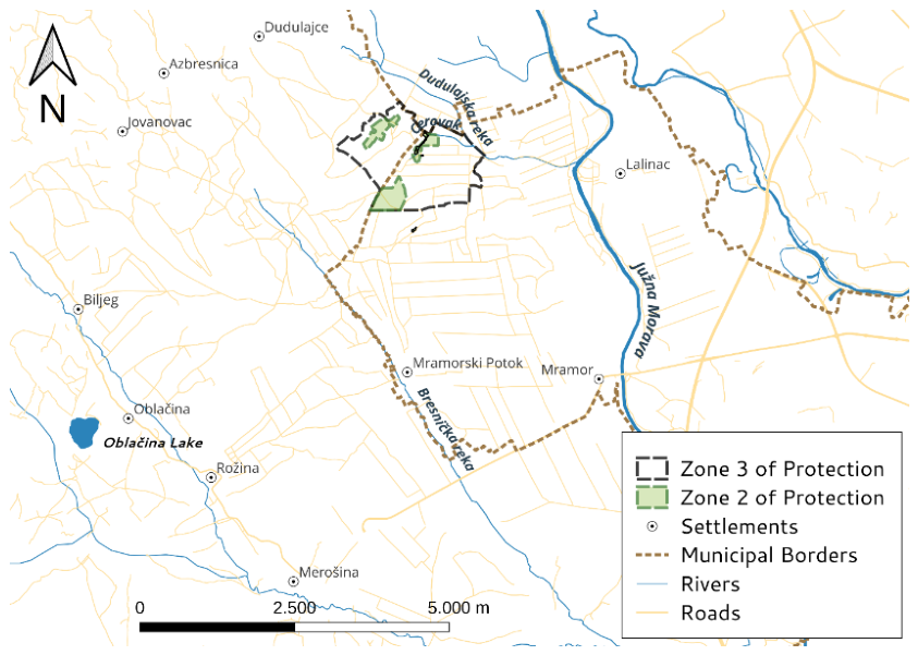
Figure 2.
Spatial distribution of FIRMS active-fire detections and survey-derived fire-associated areas across the Lalinac salt-marsh landscape. FIRMS active-fire detections are symbolized according to year of detection (ranging from yellow <2010 to red 2010–2026), while survey-derived fire-associated polygons are shown as red dashed outlines. The second- and third-degree protection zones of the Nature Monument “Lalinačka Slatina” are shown in green, with rivers included for spatial reference.
Figure 2.
Spatial distribution of FIRMS active-fire detections and survey-derived fire-associated areas across the Lalinac salt-marsh landscape. FIRMS active-fire detections are symbolized according to year of detection (ranging from yellow <2010 to red 2010–2026), while survey-derived fire-associated polygons are shown as red dashed outlines. The second- and third-degree protection zones of the Nature Monument “Lalinačka Slatina” are shown in green, with rivers included for spatial reference.
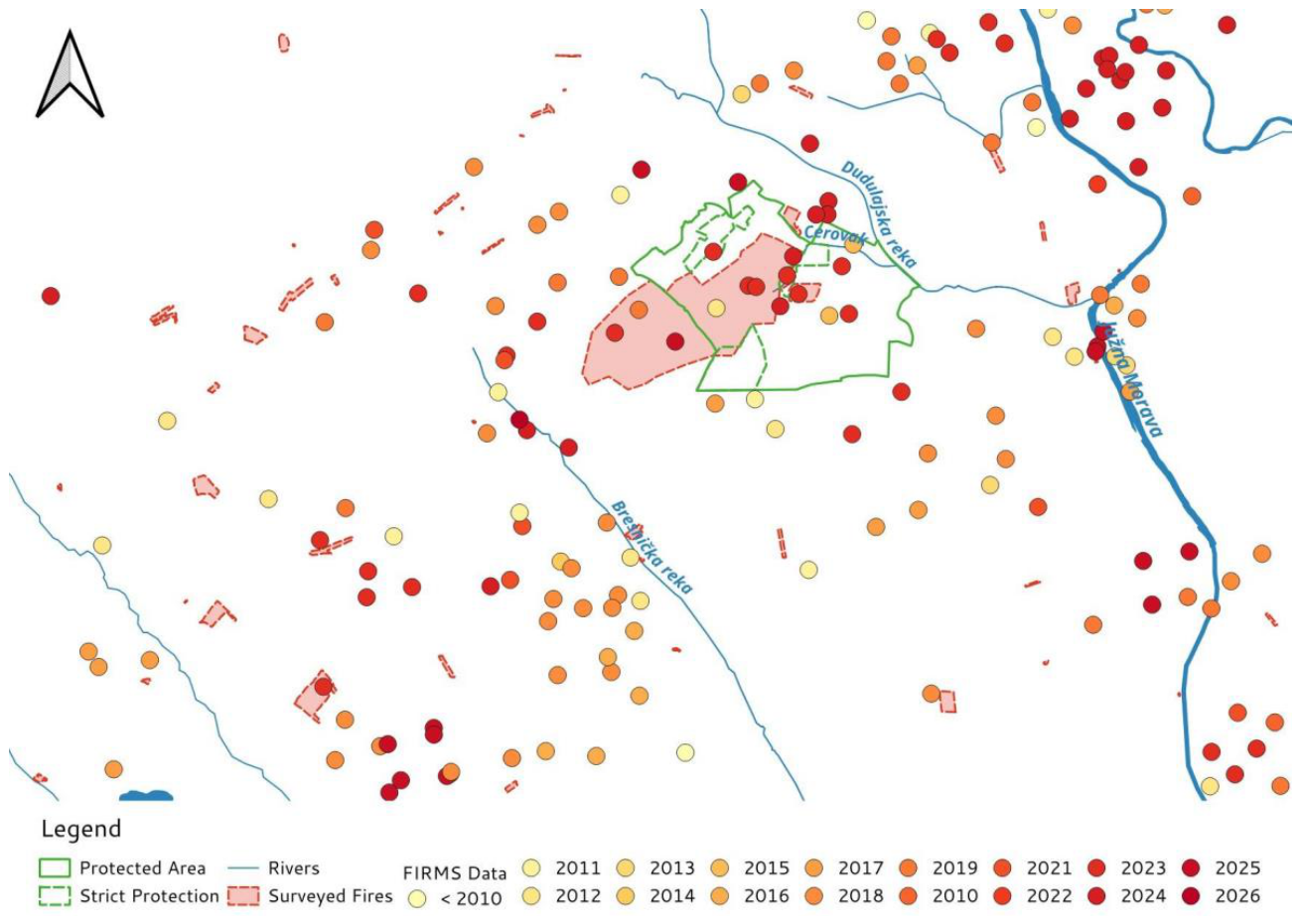
Figure 3.
Mapped biodiversity features of conservation importance. (a) Spatial distribution of selected bird habitat complexes and habitat mosaics: B1—habitat complex around Oblačina Lake; B2—southwestern habitat complex; B3—central habitat mosaic; B4—large reed-bed habitat complex; B5—south-central salt-marsh habitat mosaic; B6—central salt-marsh habitat complex; B7—central channel habitat complex; B8—upper channel habitat complex; B9—entrance valley habitat mosaic; B10—outer northeastern crossroads habitat complex. (b) Spatial distribution of selected plant subpopulations: P1—Adonis vernalis; P2—Galatella linosyris; P3—Limonium gmelinii; P4—Sternbergia colchiciflora; P5—Camphorosma monspeliaca; P6—Stachys milanii; P7—Limonium gmelinii; P8—Limonium gmelinii; P9—Camphorosma monspeliaca.
Figure 3.
Mapped biodiversity features of conservation importance. (a) Spatial distribution of selected bird habitat complexes and habitat mosaics: B1—habitat complex around Oblačina Lake; B2—southwestern habitat complex; B3—central habitat mosaic; B4—large reed-bed habitat complex; B5—south-central salt-marsh habitat mosaic; B6—central salt-marsh habitat complex; B7—central channel habitat complex; B8—upper channel habitat complex; B9—entrance valley habitat mosaic; B10—outer northeastern crossroads habitat complex. (b) Spatial distribution of selected plant subpopulations: P1—Adonis vernalis; P2—Galatella linosyris; P3—Limonium gmelinii; P4—Sternbergia colchiciflora; P5—Camphorosma monspeliaca; P6—Stachys milanii; P7—Limonium gmelinii; P8—Limonium gmelinii; P9—Camphorosma monspeliaca.
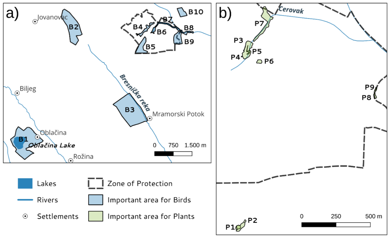
Figure 4.
Spatial exposure of biodiversity features of conservation importance to fire occurrence in NM “Lalinačka Slatina”, based on two complementary data sources. (a) Spatial distribution of selected bird areas and plant subpopulations in relation to NASA FIRMS active-fire detections; (b) their spatial relationship with survey-derived fire-associated areas reconstructed from stakeholder interviews. Comparison of the two datasets illustrates differences in the biodiversity areas identified as potentially exposed to fire.
Figure 4.
Spatial exposure of biodiversity features of conservation importance to fire occurrence in NM “Lalinačka Slatina”, based on two complementary data sources. (a) Spatial distribution of selected bird areas and plant subpopulations in relation to NASA FIRMS active-fire detections; (b) their spatial relationship with survey-derived fire-associated areas reconstructed from stakeholder interviews. Comparison of the two datasets illustrates differences in the biodiversity areas identified as potentially exposed to fire.
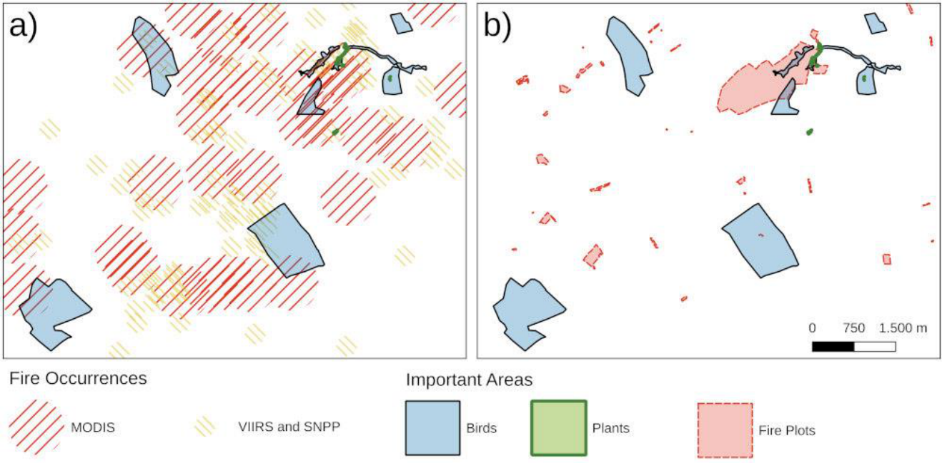

Table 1.
Negative-binomial regression model of monthly MODIS active-fire detections in relation to maximum monthly temperature (tmax) and precipitation (prec). Regression coefficients are presented as estimates ± SE, together with z-values, p-values, and incidence rate ratios (IRR) with 95% confidence intervals.
Table 1.
Negative-binomial regression model of monthly MODIS active-fire detections in relation to maximum monthly temperature (tmax) and precipitation (prec). Regression coefficients are presented as estimates ± SE, together with z-values, p-values, and incidence rate ratios (IRR) with 95% confidence intervals.
| | Estimate ± SE | Z value | P value | IRR (2.5%–97.5%) |
| Intercept | -1.096±0.583 | -1.880 | 0.060 | 0.334 (0.099–1.140) |
| tmax | 0.068±0.022 | 3.169 | 0.001 | 1.071 (1.025–1.122) |
| prec | -0.044±0.009 | -5.004 | <0.001 | 0.957 (0.940–0.972) |
Disclaimer/Publisher’s Note: The statements, opinions and data contained in all publications are solely those of the individual author(s) and contributor(s) and not of MDPI and/or the editor(s). MDPI and/or the editor(s) disclaim responsibility for any injury to people or property resulting from any ideas, methods, instructions or products referred to in the content. |
© 2026 by the authors. Licensee MDPI, Basel, Switzerland. This article is an open access article distributed under the terms and conditions of the Creative Commons Attribution (CC BY) license.
Copyright: This open access article is published under a Creative Commons CC BY 4.0 license, which permit the free download, distribution, and reuse, provided that the author and preprint are cited in any reuse.