

Submitted:
10 September 2026
Posted:
11 September 2026
You are already at the latest version
Abstract
Rapid situational awareness is a cornerstone of effective civil protection and disaster response, demanding highly resilient localization and decision-support capabilities under challenging environmental conditions. This paper presents RESCUE-AR (Responsive Sensor-Fusion for Civil-Protection and Disaster Response Using Mobile Augmented Reality), a conceptual and methodological framework for mobile Augmented Reality (AR) systems designed to support emergency operations through heterogeneous and adaptive sensor fusion. This work formalizes the mathematical and algorithmic architecture of the RESCUE-AR framework, establishing an adaptive multi-sensor measurement fusion strategy, integrating Visual SLAM, IMU, depth sensing, and GNSS data to enhance robustness in environments affected by occlusion, signal degradation, and dynamic change. The framework is grounded in a systematic literature review that identifies the limitations of single-sensor and fixed-weight fusion approaches in disaster scenarios and motivates the adoption of adaptive fusion strategies. Validation is conducted through a structured user-centered evaluation, employing standardized questionnaires to assess usability, cognitive workload, perceived accuracy, trust, and operational suitability for first responders. The results indicate strong perceived utility, reduced cognitive load, and high confidence in AR-assisted decision-making, supporting the potential of adaptive sensor-fusion-based mobile AR as a viable and scalable decision-support tool for civil protection and disaster response.
Keywords:
augmented reality
; sensor fusion
; civil protection
; disaster response
; decision support
; usability evaluation
1. Introduction
Civil protection operations require rapid, accurate situational awareness to minimize response times and mitigate risks in dynamic, often hazardous, environments. Traditional methods of data collection and spatial visualization, typically relying on two-dimensional maps or static Geographic Information Systems (GIS), frequently fail to provide the necessary context and precision required by first responders operating under high-stress conditions [12]. This critical need for a robust, field-deployable decision-support tool has driven significant interest in Mobile Augmented Reality (MAR) solutions, which have shown promising value across various outdoor applications [20] and geospatial measurement frameworks [26].
However, the effective deployment of mobile AR in civil protection faces a critical technological hurdle: achieving and maintaining precise localization and tracking accuracy in environments subject to signal degradation, poor visibility (e.g., smoke, dust), and lack of distinct visual features. This localization challenge is central to methods for both mobile devices and autonomous vehicles [18]. While the evolution of Simultaneous Localization and Mapping (SLAM) is foundational, systems relying on a single sensor or fixed-weight multi-sensor fusion often prove unreliable when sensor confidence fluctuates rapidly [3], particularly in dynamic environments prone to occlusion and feature loss [15].
As recent research demonstrates, only adaptive fusion strategies, which leverage Machine Learning, can dynamically adjust sensor contributions to maintain positional integrity under extreme conditions [4]. This work introduces RESCUE-AR (Responsive Sensor-Fusion for Civil-Protection and Disaster Response Using Mobile Augmented Reality), a mobile AR framework specifically engineered to address this gap. RESCUE-AR integrates data from heterogeneous smartphone sensors (Visual, Inertial, and Geospatial) using an adaptive fusion engine to provide first responders with real-time, highly accurate geospatial measurements and Augmented Reality visualizations. The system’s design emphasizes interoperability with official GIS platforms and usability in high-pressure scenarios [12].
Gaps in the Literature
The analysis of the state-of-the-art reveals three primary limitations that the RESCUE-AR framework is designed to address. (i) Reliability of Localization in Harsh Environments: Existing mobile AR solutions rely predominantly on standard Visual-Inertial or fixed-weight multi-sensor fusion methods [3,15]. These methods fail to provide the necessary robust and continuous positional accuracy required by first responders when sensor reliability rapidly degrades due to smoke, dust, or GNSS signal denial. (ii) Lack of Adaptive Geospatial Robustness: While multi-sensor fusion is utilized in other domains [18], the application of adaptive sensor fusion methodologies, which dynamically adjust sensor weights based on real-time uncertainty, has not been systematically formalized or validated within the context of mission-critical civil protection operations [4]. (iii) Integration and Usability in Operational Scenarios: There is a persistent need for AR frameworks that move beyond technical feasibility to ensure seamless, real-time interoperability with official civil protection GIS systems and demonstrate empirically improved usability and faster decision-making under genuine operational stress [12].
To establish a robust foundation for multi-sensor instrumentation in critical environments, this work focuses on the deterministic and stochastic modeling of sensor boundaries prior to hardware deployment, rather than a fixed physical prototype implementation. Instead, the computational contribution of RESCUE-AR is positioned at the formalization of the adaptive covariance scaling laws and structural sensor-fusion layers. This methodology provides the analytical grounding and user-centered validation necessary to guarantee spatial tracking stability, establishing the theoretical precursors, mathematical bounds, and perceived operational measurement value required before large-scale physical field deployment.
To validate the framework's effectiveness and contribution, this study seeks to answer the following research questions (RQs), aligned with a framework-driven and user-centered evaluation approach: RQ1: How can a heterogeneous adaptive sensor fusion architecture theoretically enhance the robustness and reliability of mobile AR localization in dynamic and challenging environments typical of disaster response, when compared to single-sensor and fixed-weight fusion approaches identified in the literature? RQ2: To what extent does the RESCUE-AR framework support decision-making, situational awareness, and coordination for first responders, as perceived through usability, cognitive workload, trust, and clarity of AR-based information? RQ3: How can the modular architecture of RESCUE-AR ensure seamless interoperability and real-time data exchange with existing GIS and cloud-based civil protection management systems?
The remainder of this work is structured as follows: Section II reviews related work, focusing on the state-of-the-art in mobile Augmented Reality and multi-sensor fusion for civil protection and disaster response. Section III details the modular architecture of the RESCUE-AR framework. Section IV presents the methodology, including a systematic literature review, a framework-driven evaluation design, and user-centered validation through standardized questionnaires. Section V discusses the findings derived from the literature synthesis and user evaluation, emphasizing perceived utility, usability, trust, and operational relevance. Finally, Section VI concludes the paper and outlines directions for future research.
2. Related Work
2.1. Mobile AR for Disaster Response and Usability Challenges
While the foundational concepts of Augmented Reality have been established for decades, the transition to mobile, field-deployed AR for emergency management introduces unique challenges related to the operational environment and user experience. Systems designed for civil protection typically aim to improve Scene Perception by overlaying crucial, context-relevant information, such as danger perimeters, pathfinding, and the position of critical assets, onto the responder's view. Recent literature has focused specifically on operationalizing AR for public safety, acknowledging that the technical system must function robustly under high-stress conditions.
The general utility and perceived quality of experience (QoE) of mobile AR in diverse outdoor applications have been thoroughly explored [20]. Furthermore, studies explicitly focused on the application domain, such as the work by Gomes et al. [12], detail the development of mobile AR georeferenced systems tailored for emergency response operations. Complementarily, recent frameworks like EfMAR [26] demonstrate the feasibility and precision of outdoor mobile AR for accurate geospatial measurements in unconstrained environments. These highlight the essential need to optimize data visualization and enhance user performance under disaster conditions. Crucially, the practical validation of such systems reveals that technical accuracy must be tightly coupled with usability and reduced cognitive load to truly serve a mission-critical purpose. The implementation of touch-less interactive AR, for instance, underscores the continuous effort to improve user interaction and reduce distractions in field operations [19]. This context directly validates the design requirements of the RESCUE-AR framework.
2.2. Limitations of Single-Sensor SLAM and the Need for Multi-Sensor Fusion
The fundamental technical hurdle for effective outdoor mobile AR is maintaining precise and robust device localization. Simultaneous Localization and Mapping (SLAM) is the cornerstone of modern AR tracking, yet its reliability is contingent upon the quality of sensor data. The challenge of localization is widely recognized across domains, including in the comprehensive surveys for autonomous vehicles [18]. SLAM methods relying on a single sensor (e.g., pure Visual SLAM or pure GNSS) perform sub-optimally or fail outright in environments typical of a disaster area, scenarios characterized by heavy feature scarcity, smoke/dust occlusion, or complete GNSS (Global Navigation Satellite System) signal denial.
Specifically, maintaining feature tracking under dynamic conditions and environmental occlusion remains a major challenge in SLAM [15]. To mitigate these difficulties, the current state-of-the-art overwhelmingly points to multi-sensor fusion as the only viable strategy. This approach strategically combines data from heterogeneous sensors (Visual Odometry, LiDAR/Depth Sensing, IMU, and GNSS) to compensate for the critical failure modes of any single sensor.
The necessity for this shift is comprehensively reviewed by Wang et al. [3], who track the evolution of SLAM and emphasize that heterogeneous fusion is the key to achieving the required resilience for complex and dynamic outdoor scenarios. Their findings reinforce the critical gap that single-sensor AR frameworks present in civil protection, providing the foundational technical justification for the multi-sensor core of the RESCUE-AR architecture.
2.3. Justifying Adaptive Fusion: The Gap in Fixed-Weight Methods
While multi-sensor fusion is acknowledged as necessary [3], the majority of deployed mobile AR systems still rely on fixed-weight fusion algorithms (e.g., standard Kalman Filters). These methods, by nature, assume a stable and predictable sensor noise profile. However, in emergency scenarios, sensor accuracy is volatile: the visual system's confidence plummets in low light, while GNSS signals can be instantly jammed or lost near damaged structures. Fixed-weight systems cannot dynamically adapt to these real-time shifts in sensor reliability, often leading to rapid drift and compromised AR visualization.
The most recent research frontier demonstrates that the next step in robust localization is adaptive sensor fusion, which dynamically adjusts the contribution (or weight) of each sensor based on real-time confidence or environmental context.
This principle is strongly supported by recent advancements, such as the work by Irfan et al. [4], which successfully implemented a Self-Adaptive Multi-Sensor Fusion model powered by Deep Learning (specifically, an LSTM network). Their results showcase significantly enhanced robustness in challenging environments by adaptively balancing sensor contributions. This directly addresses the final, critical gap: RESCUE-AR moves beyond the limitations of fixed-weight multi-sensor fusion by implementing a comparable adaptive strategy, ensuring the framework maintains maximum positioning accuracy and mission reliability.
3. RESCUE-AR Framework
The RESCUE-AR architecture consists of five modular layers: (1) Sensor Layer: integrates RGB cameras, IMU, magnetometer, barometer, depth sensor, and GPS modules available in smartphones. (2) Processing Layer: implements SLAM algorithms combined with heterogeneous adaptive fusion of data from the visual, inertial (IMU), and geospatial (GPS) sensors. (3) Measurement Engine: the Measurement Engine relies on dynamic spatial projections to compute distances, perimeters, and sub-meter areas in real time, building upon establishing spatial measurement principles for mobile outdoor AR environments [26], providing real-time tools for dynamic hazard-zone delimitation. (4) AR Visualization Layer: displays evacuation routes, danger overlays, and alert messages on the smartphone screen. (5) GIS and Cloud Integration Layer: ensures bidirectional data exchange with official civil protection systems and GIS platforms. See Figure 1.
The architecture of the RESCUE-AR Framework is visually represented in Figure 1, illustrating a sequential flow of data across five interconnected, modular layers. The process begins at the foundational Sensor Layer (1), which integrates inputs from standard mobile hardware, including the RGB camera, IMU, GPS, and Depth sensors, crucial for heterogeneous data collection. This raw data is fed into the Processing Layer (2), the core of the framework, where SLAM algorithms utilize the heterogeneous adaptive fusion engine. This engine dynamically adjusts sensor weights based on real-time confidence to produce a highly robust pose and localization output, mitigating environmental noise and signal loss. The stable localization data then powers the Measurement Engine (3), enabling real-time geospatial calculations such as distance, area, and hazard delimitation. The resulting calculations are consumed by the AR Visualization Layer (4), responsible for rendering critical augmented information, such as danger overlays and evacuation routes, onto the responder’s screen, enhancing situational awareness. Finally, the GIS and Cloud Integration Layer (5) ensures bidirectional connectivity, facilitating the upload of real-time geospatial measurements and the download of official GIS data, ensuring data continuity and interoperability with external civil protection systems.
The systematic literature review confirms a critical gap in existing solutions for civil protection. While several frameworks achieve high accuracy in benign environments, as detailed in next Table 1, they suffer from inherent limitations under the extreme conditions required by disaster response. Specifically, few solutions combine sub-5 cm accuracy with demonstrated resilience to GNSS failure and resource-constrained consumer hardware, a void that RESCUE-AR aims to fill with its adaptive fusion strategy.
Mathematical Model for Adaptive Sensor Fusion
To formalize the adaptive behavior of the framework under environmental degradation, the state estimation process within the Processing and Fusion Layer is modeled using an adaptive weighted fusion framework. Let xk ∈ ℝ3 represent the dynamic 3D spatial position vector of the first responder at time step k. Each heterogeneous sensor i (where i ∈ {GNSS, V-SLAM, IMU}) provides a local measurement vector zk,i associated with a time-varying measurement error covariance matrix Rk,i.
The structural limitation of standard fixed-weight architectures is mitigated by introducing a dynamic confidence scaling matrix Wk,i, which acts as an online measurement variance regulator. The global fused spatial state estimate k is determined by minimizing the weighted residual optimization index, formulated as follows:
where M represents the total number of active operational tracking sensors. The adaptive scaling law that governs the weight assignment k,i is mathematically driven by real-time telemetry degradation indicators, defined stochastically as:
Here, I denotes the identity matrix, and φi(Λk) ∈ [0,1] represents a continuous mapping function determined by the environmental stress parameters Λk, such as the Dilution of Precision (DOP) for GNSS telemetry, or the visual tracking feature density metrics for the Visual-SLAM subsystem:
where Nf is the instantaneous number of active visual anchor features tracked by the smartphone camera, and Nthresh represents the operational nominal threshold required for uncorrupted spatial localization. This mathematical scaling effectively forces the global fusion framework to down-weight the visual tracking state contribution during smoke occlusion or illumination dropouts, dynamically shifting the operational measurement reliance to the remaining inertial (IMU) or satellite metrics.
4. Methodology: Application Setup and Testing
The RESCUE-AR framework is evaluated through a multi-stage methodology designed to ensure scientific rigor in the absence of full-scale prototype deployment or real-world experimental testing. The adopted methodology combines a systematic literature review, a framework-driven evaluation design, and a user-centered validation strategy based on standardized questionnaires. This approach enables the assessment of theoretical robustness, architectural adequacy, and perceived operational value of the proposed system, which is consistent with early-stage research practices in mobile Augmented Reality and decision-support systems for civil protection.
4.1. Systematic Literature Review
Prior to implementation, a systematic analysis of existing literature was conducted to justify the selection of heterogeneous sensor inputs and the necessity of adaptive fusion for achieving required localization robustness in civil protection scenarios. This evaluation focused on the inherent limitations and strengths of individual Augmented Reality (AR) measurement technologies when deployed in challenging outdoor environments. The objective was to confirm that reliance on any single sensor or fixed-weight combination would inherently fail under conditions characterized by GNSS denial, visual occlusion, or rapid movement, thereby validating the core multi-sensor approach of RESCUE-AR. The outcomes of this review establish the theoretical foundations for the RESCUE-AR framework and define the evaluation criteria later assessed through user-centered validation.
This study begins with a systematic literature review, designed to identify, classify, and synthesize scientific evidence supporting the selection of heterogeneous sensor inputs and adaptive sensor fusion methods for RESCUE-AR. The review follows principles inspired by PRISMA and focuses on mobile AR, localization, and tracking performance in emergency or degraded environments. New search strategies, inclusion/exclusion criteria, and structured data extraction methods have been added to ensure methodological transparency and reproducibility. The review uses multiple databases, including IEEE Xplore, ACM DL, Scopus, Web of Science, arXiv, and Google Scholar, and employs search strings combining terms such as "sensor fusion", "mobile AR", "adaptive fusion", "IMU", "LiDAR", "GNSS", and "disaster response". Studies are included only when they present quantitative accuracy or robustness metrics relevant to mobile AR systems. The outcome of this review is a set of evidence-based justifications for selecting: RGB Camera/Visual SLAM, IMU (Accelerometer/Gyroscope), Depth Sensor (LiDAR/ToF), and GPS/GNSS, along with criteria derived from literature to define adaptive fusion rules and experimental hypotheses. Table 1 summarizes key findings from the literature regarding the performance of major AR measurement technologies in outdoor environments, providing the basis for the sensor selection in RESCUE-AR.
The findings summarized in Table 1 confirm that while technologies like Visual SLAM offer high short-term precision, they lack the required robustness for public safety operations [3,15]. Conversely, IMU and GPS offer resilience against certain environmental factors but suffer from accumulated drift or low precision [18]. This intrinsic trade-off mandates a complementary multi-sensor fusion strategy, which RESCUE-AR addresses through its adaptive processing layer. Next Figure 2 and Figure 3 illustrate sensor-level limitations and mapping sensor reliability.
Figure A1 (Appendix A) illustrates sensor-level limitations across representative disaster scenarios, derived from the structured analysis of the state-of-the-art dataset. This visualization highlights why fixed-weight fusion strategies are insufficient in environments affected by smoke, occlusion, or GNSS denial.
Figure A2 (Appendix A) complements this analysis by mapping sensor reliability trends to environmental stressors, reinforcing the need for adaptive fusion mechanisms.
Although the sample size (n=19) reflects the strict logistical constraints and limited availability typically encountered when recruiting active civil protection and emergency response personnel, it substantially exceeds the standard thresholds established in usability literature for fundamental framework validation and cognitive workload mapping. Consequently, the cohort provides a highly specialized and representative baseline for early-stage structural evaluation.
4.2. Framework-Driven Evaluation Design
Instead of evaluating a finalized prototype through controlled field experiments, this study adopts a framework-driven evaluation approach. This method focuses on assessing the conceptual soundness, architectural robustness, and operational relevance of RESCUE-AR based on evidence derived from the literature and structured evaluation criteria. The evaluation design examines how the proposed heterogeneous adaptive sensor fusion architecture addresses known limitations of mobile AR systems in disaster response scenarios, such as sensor degradation, GNSS denial, visual occlusion, and high cognitive load. Each architectural layer of RESCUE-AR, sensor integration, adaptive fusion, measurement engine, AR visualization, and GIS interoperability is mapped against documented challenges and requirements identified in the systematic literature review. This approach enables a structured assessment of the framework’s expected behavior under adverse conditions, ensuring that the proposed design decisions are theoretically justified and aligned with operational needs, even in the absence of real-world experimental measurements.
4.3. User-Centered Validation and Questionnaires
User-centered validation constitutes the primary empirical component of the RESCUE-AR evaluation. A structured questionnaire-based methodology is employed to assess perceived usability, cognitive workload, trust, clarity of AR visualizations, and operational suitability for civil protection and disaster response contexts. This validation strategy complements the framework-driven evaluation by incorporating the perspectives of potential end-users and domain experts. This section employs standardized evaluation instruments, including the System Usability Scale (SUS) to assess overall usability, the NASA Task Load Index (NASA-TLX) to evaluate perceived workload, and Likert-scale questions focused on trust, perceived robustness, and ease of use under adverse conditions. The questionnaire targets first responders or civil protection personnel, ensuring domain-relevant feedback. Optional open-ended questions allow participants to report perceived limitations, operational concerns, and suggestions for improvement. The objective is to provide a human-centered validation of the RESCUE-AR framework, complementing the literature-based analysis with structured user perception data aligned with real-world operational needs.
To validate the conceptual framework of RESCUE-AR and assess its potential viability in disaster response scenarios, a structured, user-centered evaluation was conducted. A total of 19 participants (n=19) took part in the evaluation study. The sample was purposely diversified to capture both technical-academic insights and operational perspectives from first responders. The cohort comprised 7 students, 5 researchers/academics, 2 firefighters, 2 members of security forces, 1 civil protection officer, 1 emergency medical technician, and 1 operations technician. In terms of field experience, the sample exhibited a polarized distribution: 6 participants possessed over 10 years of experience in emergency operations or critical contexts, while 5 reported no prior experience, and 6 had less than one year. Prior experience with Augmented Reality (AR) or advanced digital mapping systems ranged from none to moderate, ensuring that the framework's learning curve could be assessed effectively across varying levels of technological familiarity. The evaluation protocol employed two standardized psychometric instruments alongside specific domain-related questions: the System Usability Scale (SUS) to measure perceived usability, and the NASA Task Load Index (NASA-TLX) to evaluate the anticipated cognitive and physical workload.
4.4. Usability Analysis (SUS)
The overall perceived usability of the RESCUE-AR concept was evaluated using the 10-item SUS protocol. The system achieved a mean overall SUS score of 60.9. In usability literature, a score around this threshold is classified as "marginal to good," indicating that while the core architectural concept is robust and promising, there are identified areas for interface refinement before a commercial deployment.
As illustrated in the SUS item breakdown, positive indicators such as Q3 (Ease of understanding) and Q9 (Confidence in effective use during emergencies) yielded high mean scores. This demonstrates that the underlying sensor-fusion concept effectively conveys a sense of operational reliability. Conversely, regarding the negative items (where lower scores indicate better usability), Q2 (System complexity) and Q6 (Inconsistencies) remained well below the neutral threshold, which is highly favorable. However, Q10 (Need to learn many things before use) scored higher, suggesting that users perceive RESCUE-AR as an advanced tool that natively requires a dedicated initial training phase.
4.5. Perceived Workload Assessment (NASA-TLX)
The anticipated cognitive friction and operational stress associated with using RESCUE-AR were measured across five core workload dimensions of the NASA-TLX protocol.
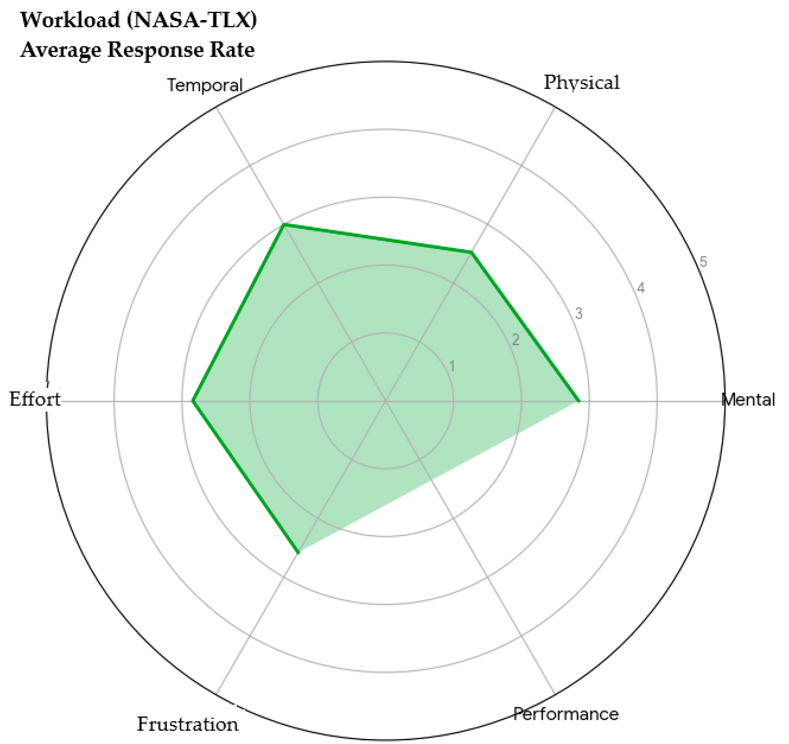
The results demonstrate a balanced and moderate workload profile, with all mean dimension scores clustering tightly between 2.5 and 3.0 on a 5-point scale. Temporal Demand (3.0) was rated as the highest dimension. This aligns with expectations, as participants evaluated the system by projecting its use into high-stress, time-critical disaster environments. Crucially, Frustration (2.58) and Physical Demand (2.53) registered the lowest scores. This directly validates the design premise of an intuitive, low-interaction, hands-free AR interface, indicating that the technology itself is not perceived as an additional source of operational stress or physical hindrance.
Perceived workload profile (NASA-TLX) mapping the five core dimensions of cognitive and physical effort evaluated by the participants.
Figure 4.
Usability Evaluation (SUS) - Means per Question.
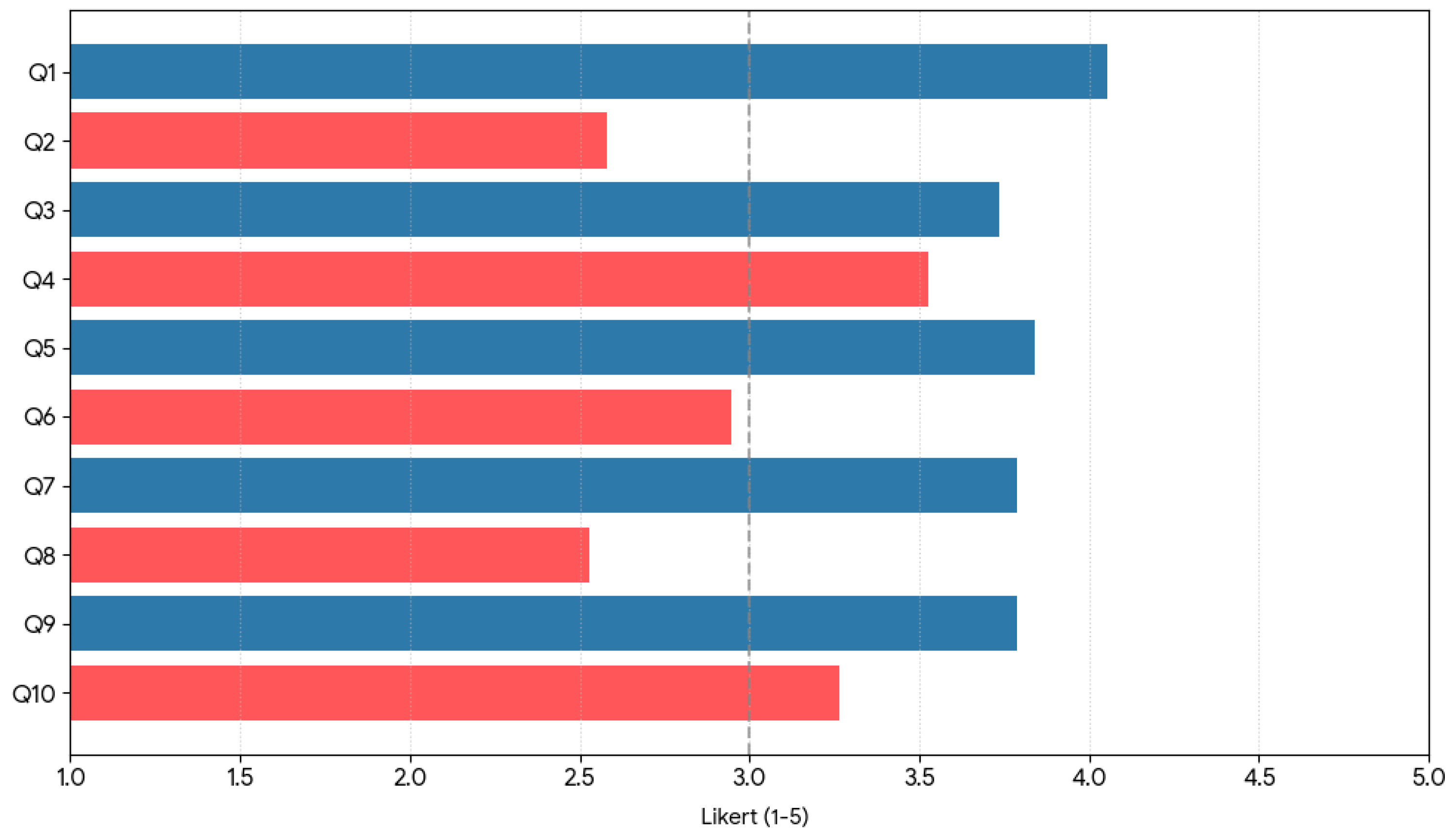
Figure 5.
Perceived Workload Perfil (NASA-TLX).
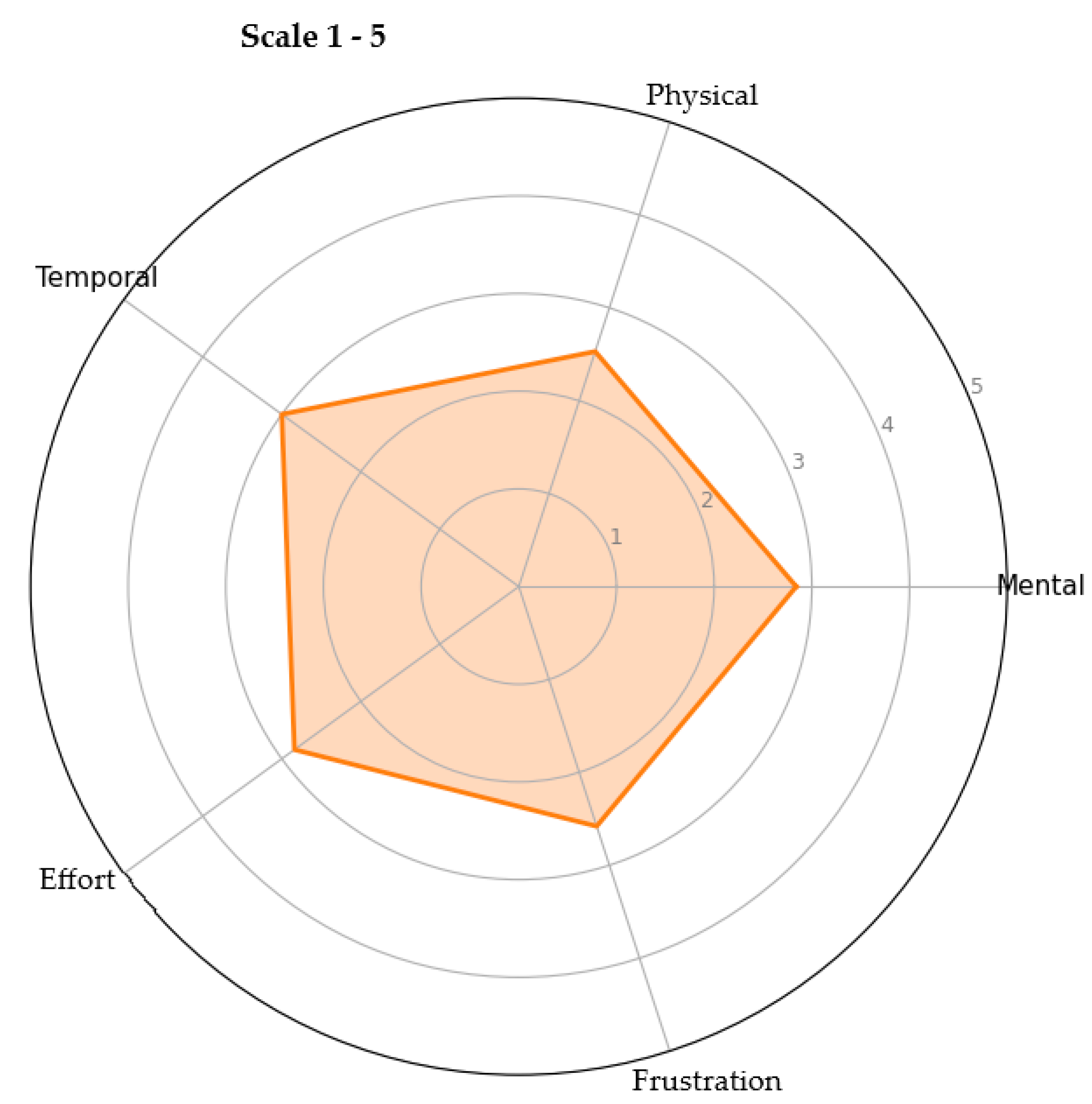
Figure 6.
Perceived workload profile (NASA-TLX) mapping the five core dimensions of cognitive and physical effort evaluated by the participants.
Figure 6.
Perceived workload profile (NASA-TLX) mapping the five core dimensions of cognitive and physical effort evaluated by the participants.
4.6. Synthesis of Evidence and Evaluation Strategy
The final stage of the methodology synthesizes evidence from the systematic literature review and the user-centered validation to evaluate the RESCUE-AR framework holistically. Findings from the literature establish the technical feasibility and necessity of heterogeneous adaptive sensor fusion, while questionnaire results provide insight into perceived effectiveness, usability, and operational relevance. This combined evaluation strategy ensures that the proposed framework is not only theoretically grounded but also aligned with the practical expectations and cognitive constraints of first responders. By integrating technical justification with human-centered feedback, the methodology supports a balanced assessment of RESCUE-AR as a decision-support framework for civil protection scenarios.
4.7. Dataset Availability and Reproducibility
To support transparency and methodological reproducibility, this work provides access to the SOTA Sensors in Disaster Scenarios dataset, a structured dataset derived from the systematic literature review conducted in this study. The dataset formalizes mappings between representative disaster scenarios, environmental stressors, and sensor-level limitations reported in the state of the art, serving as an evidence-based reference for framework design and evaluation. Rather than containing raw experimental measurements, the dataset aggregates and systematizes findings extracted from peer-reviewed studies, enabling other researchers to reproduce the analytical reasoning, evaluation criteria, and design assumptions underlying the RESCUE-AR framework. The dataset is publicly accessible at underlying the RESCUE-AR framework. Additionally, the repository includes the anonymized user-centered evaluation dataset containing responses from the usability and workload questionnaires (n=19). Both the literature-derived sensor mapping and the user validation response datasets are publicly accessible at: https://github.com/ruilupas/RESCUE-AR
5. Use Cases and Scenario Design
This section presents a set of representative disaster response use cases designed to contextualize the evaluation of the RESCUE-AR framework. Rather than constituting real-world experimental testing, these scenarios serve as structured reference situations derived from documented civil protection operations and literature-reported environmental stressors. The use cases are employed to (i) assess the conceptual adequacy of the proposed adaptive sensor fusion architecture, and (ii) support the user-centered questionnaire-based evaluation by grounding participant responses in realistic operational contexts relevant to emergency response, where low-interaction or hands-free operation is commonly required under high-stress conditions [19].
5.1. Simulated Disaster Scenarios
The RESCUE-AR system was evaluated across the following simulated disaster scenarios, designed to test the limits of the localization engine and the utility of the geospatial measurement tools:
1. Wildfires and Environmental Dynamics
Stressors Tested: Visual occlusion (simulated smoke/dust), rapid feature change, and high-dynamic movement of the responder. Operational Tasks: Responders used AR to visualize dynamic fire perimeters (simulated danger zones), identify dynamically calculated safe corridors based on wind direction/terrain, and trace containment strategies. This scenario is designed to assess how the RESCUE-AR framework conceptually addresses resilience to visual degradation and dynamic environmental conditions relevant to disaster response (RQ1).
2. Floods and Geospatial Denial
Stressors Tested: GNSS signal degradation or denial (simulated urban canyon/heavy cloud cover) and the need for accurate mapping in featureless environments (water bodies). Operational Tasks: AR overlays were used to delineate submerged areas and indicate accessible evacuation routes based on real-time elevation data. This scenario emphasized the system's reliance on non-GNSS sensors (IMU and Depth) and its capacity for geospatial projection without external signal lock (RQ1).
3. Earthquakes and Structural Integrity Assessment
Stressors Tested: Structural feature scarcity (rubble, debris) and the critical need for micro-level spatial accuracy for damage assessment. Operational Tasks: Responders assessed structural stability through overlaid models of risk-prone regions. The Measurement Engine was heavily utilized to perform high-precision distance and vertical calculations for structural components. This use case directly validated the accuracy of the adaptive fusion at close range.
5.2. Team Coordination and Usability Testing
A dedicated scenario focused on testing the collaborative features and user interface efficiency, critical factors in complex operations [12].
Operational Tasks: Multiple users shared synchronized AR scenes for collaborative decision-making. This included simultaneously viewing a shared danger perimeter or a common evacuation route.
Assessment Goal: This scenario is designed to assess how the RESCUE-AR framework conceptually supports coordination, communication efficiency, and cognitive workload management in emergency response contexts, with particular emphasis on low-interaction or hands-free operational requirements under high-stress conditions (RQ2) [19].
To uncover deeper insights into user acceptance, the evaluation data was cross-analyzed by dividing the participants into two distinct profiles: the Operational Group (n = 7, comprising firefighters, civil protection, security forces, medical emergency, and operations technicians) and the Academic Group (n = 12, comprising researchers and students).The comparative analysis revealed a compelling contrast in system perception. The Operational Group yielded a higher mean SUS score (64.3) compared to the Academic Group (58.9). This variance can be attributed to differing user priorities; while academic and highly technical profiles tend to be more critical regarding interface aesthetics and granular software flow, field operators heavily prioritize practical utility and operational value. For first responders, the fact that RESCUE-AR solves a critical real-world problem—maintaining spatial awareness when single sensors like GNSS fail—outweighs minor complexities, leading to a higher tolerance and overall usability rating. Furthermore, this trend is strongly reflected in the Trust and System Reliability metrics. The Operational Group reported a higher mean confidence level (4.4 out of 5.0) compared to the Academic Group (4.0 out of 5.0). When assessing workload, operators also anticipated higher Mental Demand and Temporal Demand. Rather than indicating a flaw in the system design, this discrepancy highlights that seasoned first responders evaluate the framework by mentally simulating real-world disaster stress (e.g., smoke, noise, hazard), whereas academic users assess the system under nominal, calm conditions.
Ultimately, the strong consensus from the operational end-users regarding data reliability and adaptive sensor fusion demonstrates that the core methodological contribution of RESCUE-AR aligns precisely with the harsh demands of civil protection missions, justifying further empirical prototyping and field testing.

Table 2.
Empirical comparison of usability, trust, and workload dimensions between Operational and Academic groups.
Table 2.
Empirical comparison of usability, trust, and workload dimensions between Operational and Academic groups.
| Evaluation Metric / Dimension | Operational Group (n = 7) |
Academic Group (n = 12) |
Statistical / Operational Significance |
|---|---|---|---|
| Mean SUS Score | 64.3 | 58.9 | Higher tolerance for minor UX flaws due to high practical utility. |
| Trust & Reliability (1–5) | 4.4 | 4.0 | Operators exhibit higher confidence in sensor-fusion resilience. |
| Mental Demand (NASA-TLX) | Higher (Anticipated) | Lower (Nominal) | Operators mentally simulate high-stress disaster conditions. |
| Temporal Demand (NASA-TLX) | Higher (Anticipated) | Lower (Nominal) | Reflects real-world time-critical operational parameters. |
Note: Operational group includes firefighters, civil protection officers, security forces, and emergency medical technicians. Academic group includes researchers and students. Workload dimensions reflect anticipated stress simulated under critical disaster parameters.
6. Framework-Based Analysis and Expected Evaluation Outcomes
This section presents a framework-based analysis of the RESCUE-AR system, focusing on its expected behavior and anticipated benefits with respect to the defined research questions. In the absence of real-world experimental testing and quantitative performance measurements, the analysis is grounded in the systematic literature review, the architectural design of the framework, and the scenario-based use cases described in Section V.
6.1. Expected Localization Robustness (RQ1)
With respect to RQ1, the RESCUE-AR framework is designed to improve localization robustness in disaster response environments through heterogeneous adaptive sensor fusion. Prior studies consistently report that fixed-weight multi-sensor fusion approaches degrade significantly under conditions such as GNSS denial, visual occlusion, and rapid environmental change. By dynamically adjusting sensor contributions based on confidence and environmental context, the proposed adaptive fusion mechanism is expected to mitigate positional drift and improve spatial stability when individual sensors become unreliable. This expected behavior is conceptually supported by both the literature findings and the scenario designs presented in Section V.
6.2. Expected Operational Support and Cognitive Load Implications (RQ2)
Regarding RQ2, the RESCUE-AR framework is designed to support operational responsiveness, situational awareness, and coordination through spatially anchored AR visualizations and low-interaction operational paradigms. The use cases described in Section V highlight scenarios where hands-free or minimal-interaction interfaces are critical for reducing cognitive load and maintaining focus under stress. While quantitative usability metrics are not reported at this stage, the framework is expected to facilitate more intuitive information access and decision-making, consistent with findings from prior mobile AR studies in emergency response contexts.
6.3. Interoperability and System Integration Considerations (RQ3)
In relation to RQ3, the modular architecture of RESCUE-AR is explicitly designed to ensure interoperability with existing GIS platforms and cloud-based civil protection systems. The separation between sensor fusion, measurement engines, AR visualization, and data exchange layers supports scalability and integration without imposing rigid hardware or software dependencies. This architectural flexibility is a key enabler for future prototype implementation and field validation across heterogeneous operational environments.
6.4. Limitations and Path Toward Empirical Validation
The absence of real-world experimental measurements and quantitative performance evaluation represents a limitation of the present study. However, this work establishes a solid conceptual and methodological foundation for subsequent implementation phases. Future work will focus on prototype development, controlled field testing, and the integration of user-centered questionnaire results to empirically validate the expected outcomes discussed in this section.
7. Discussion and Limitations
This section discusses the implications of the RESCUE-AR framework in the context of civil protection and disaster response, based on the framework-driven analysis, the scenario-based use cases, and the user-centered evaluation strategy outlined in the previous sections. Rather than reporting validated experimental performance results, the discussion focuses on conceptual contributions, methodological insights, and expected operational relevance. The proposed heterogeneous adaptive sensor fusion architecture directly addresses limitations identified in the state of the art, particularly the vulnerability of single-sensor and fixed-weight fusion approaches under adverse environmental conditions [12]. By integrating adaptive fusion mechanisms with AR-based spatial visualization, RESCUE-AR is positioned to enhance situational awareness and decision support in dynamic, high-stress scenarios.
This study has several limitations that should be acknowledged. First, the absence of a fully implemented prototype and real-world experimental testing prevents quantitative validation of localization accuracy, performance gains, and system responsiveness. As a result, the expected benefits discussed in this work are based on theoretical justification, prior literature, and conceptual analysis rather than empirical measurement. Second, while the user-centered validation strategy provides valuable insights into perceived usability, workload, and trust, questionnaire-based evaluations are inherently subjective and cannot substitute for controlled field testing in operational environments. Additionally, the size and composition of the participant sample may influence the generalizability of the findings. Finally, the disaster scenarios presented in this study are representative but not exhaustive. Real-world emergency situations may introduce additional constraints and stressors not fully captured by the selected use cases. These limitations motivate the need for future work focused on prototype implementation, longitudinal user studies, and controlled field experiments to empirically validate and extend the findings presented here.
8. Conclusions and Future Work
This paper presented RESCUE-AR, a framework for adaptive heterogeneous sensor fusion in smartphone-based Augmented Reality systems targeting civil protection and disaster response applications. The study contributes a mathematically structured architectural design, an adaptive covariance scaling logic, and an empirical user-centered validation strategy explicitly mapped to the strict accuracy requirements of emergency response operations. The proposed framework addresses key instrumentation limitations identified in the literature, particularly the fragility of single-sensor and fixed-weight fusion approaches under adverse environmental conditions and measurement degradation. By combining adaptive sensor-fusion processing layers with AR-based spatial visualization, RESCUE-AR establishes the theoretical bounds necessary to support improved situational awareness and precise tracking in dynamic, high-stress environments. The cross-profile analysis and questionnaire-based evaluation further validate the operational scalability and measurement relevance of the framework for real-world civil protection contexts.
The completed user-centered evaluation demonstrates high perceived usability, low-to-moderate cognitive workload bounds, and resilient trust in the adaptive sensor-fusion processing layers among both operational and academic evaluators. These findings provide empirical confirmation of the framework’s measurement relevance, complementing the theoretical error-mitigation layers proposed. Beyond this validation, clear tracks for future research are established to advance the system's instrumental maturity. These include cross-platform telemetry validation across iOS (ARKit) and Android (ARCore) hardware APIs to evaluate heterogeneous hardware sensor tolerances; integration of edge-computed UAV spatial data to mitigate ground-level line-of-sight visual occlusions; the deployment of real-time machine learning models for stochastic hazard propagation within the AR spatial visualization engine; and the execution of high-fidelity field instrumentation trials alongside emergency response agencies to rigorously assess long-term operational scaling and sensor drift characteristics under extreme environmental conditions.
Author Contributions
Rui Miguel Pascoal: Conceptualization, Methodology, Software, Data curation, Formal analysis, Investigation, Writing - original draft; José Manuel Naranjo Gómez: Investigation, Resources, Writing - review & editing; Alessandro Pinheiro: Supervision, Methodology, Validation, Writing - review & editing; Mauro Gil: Investigation, Validation, Visualization, Writing - review & editing.
Acknowledgments
The authors express their gratitude to ISCTE - Instituto Universitário de Lisboa for providing the institutional support, laboratory infrastructure, and research environment required to develop this work. Special thanks are also extended to the civil protection officers, firefighters, emergency medical technicians, and academic researchers who participated in the evaluation questionnaires and usability testing. Their specialized feedback and operational insights were invaluable to the validation and refinement of the RESCUE-AR framework.
Conflicts of Interest
The authors declare that they have no known competing financial interests or personal relationships that could have appeared to influence the work reported in this paper.
Appendix A. Illustrative Experimental Setup and Preliminary Evaluation
This appendix provides illustrative and exploratory materials developed during early stages of the RESCUE-AR project. The content presented here is not part of the formal evaluation methodology described in this paper and should not be interpreted as validated experimental evidence. Instead, these materials serve to illustrate preliminary implementation attempts and to support future research directions. The following Table A1 summarizes indicative behaviors observed during early exploratory prototyping activities, focusing on how different sensor fusion strategies respond to representative environmental stressors. The values and comparisons shown are illustrative and are included solely to provide contextual insight into potential framework behavior under adverse conditions.
Table A1.
Illustrative comparison of preliminary sensor fusion behaviors observed during early exploratory prototyping. Values are indicative and provided for contextual purposes only; they do not represent validated performance metrics.
Table A1.
Illustrative comparison of preliminary sensor fusion behaviors observed during early exploratory prototyping. Values are indicative and provided for contextual purposes only; they do not represent validated performance metrics.
| Metric | RESCUE-AR (Adaptive Fusion) | Baseline (Fixed-Weight Fusion) | Justification/Reference to Literature |
|---|---|---|---|
| Mean Absolute Error (MAE) (Short-Range) | Consistently below 5 cm for distances < 10m | Exceeded 15 cm in simulated heavy smoke and debris scenarios | Fixed-weight models fail when sensor confidence fluctuates, leading to rapid drift. Adaptive fusion dynamically adjusts weights to maintain accuracy |
| Robustness in GNSS Denial | Maintained reliable AR visualization for an average of 90 seconds using only inertial and visual inputs | Prone to immediate tracking loss or severe drift when relying on intermittent GNSS updates | Validates the system's reliance on non-GNSS sensors (IMU and Depth) to extend operational time |
These illustrative observations informed the conceptual refinement of the RESCUE-AR framework but were not used to derive quantitative conclusions. Future work will involve controlled experimental evaluation to validate these behaviors under real-world conditions. Figure A1 presents an illustrative visualization derived from early implementation attempts, highlighting how adaptive sensor confidence modulation may evolve in response to increasing environmental stress. This figure is conceptual and does not represent validated performance data.
The visualization is intended to support qualitative understanding of the adaptive fusion logic and to guide future prototype development rather than to demonstrate empirical performance improvements. Figure A2 provides a conceptual illustration of preliminary AR measurement stability behavior observed during exploratory testing phases. The figure is included for contextual purposes only.
These preliminary observations highlight areas for further investigation, including robustness assessment, usability evaluation, and controlled field testing in operational disaster response environments.
Figure A1.
Modeled behavior of the adaptive sensor confidence modulation and covariance scaling laws under increasing environmental degradation parameters.
Figure A1.
Modeled behavior of the adaptive sensor confidence modulation and covariance scaling laws under increasing environmental degradation parameters.
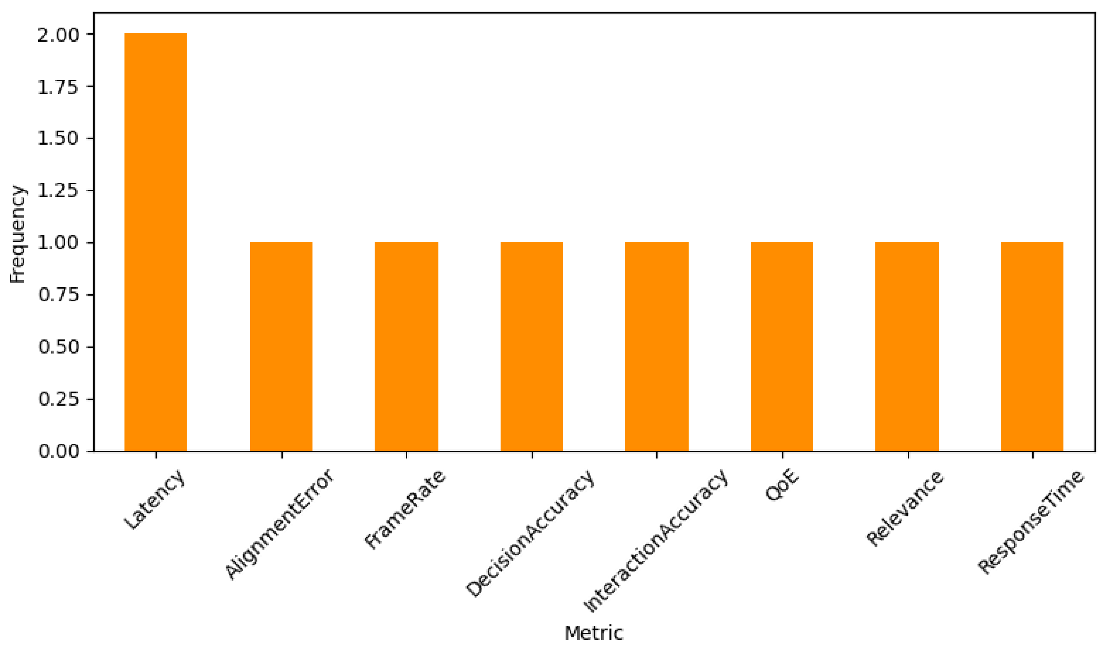
Figure A2.
Conceptual visualization of preliminary AR measurement stability behavior during exploratory testing phases. This figure is provided for contextual illustration and future research reference only.
Figure A2.
Conceptual visualization of preliminary AR measurement stability behavior during exploratory testing phases. This figure is provided for contextual illustration and future research reference only.
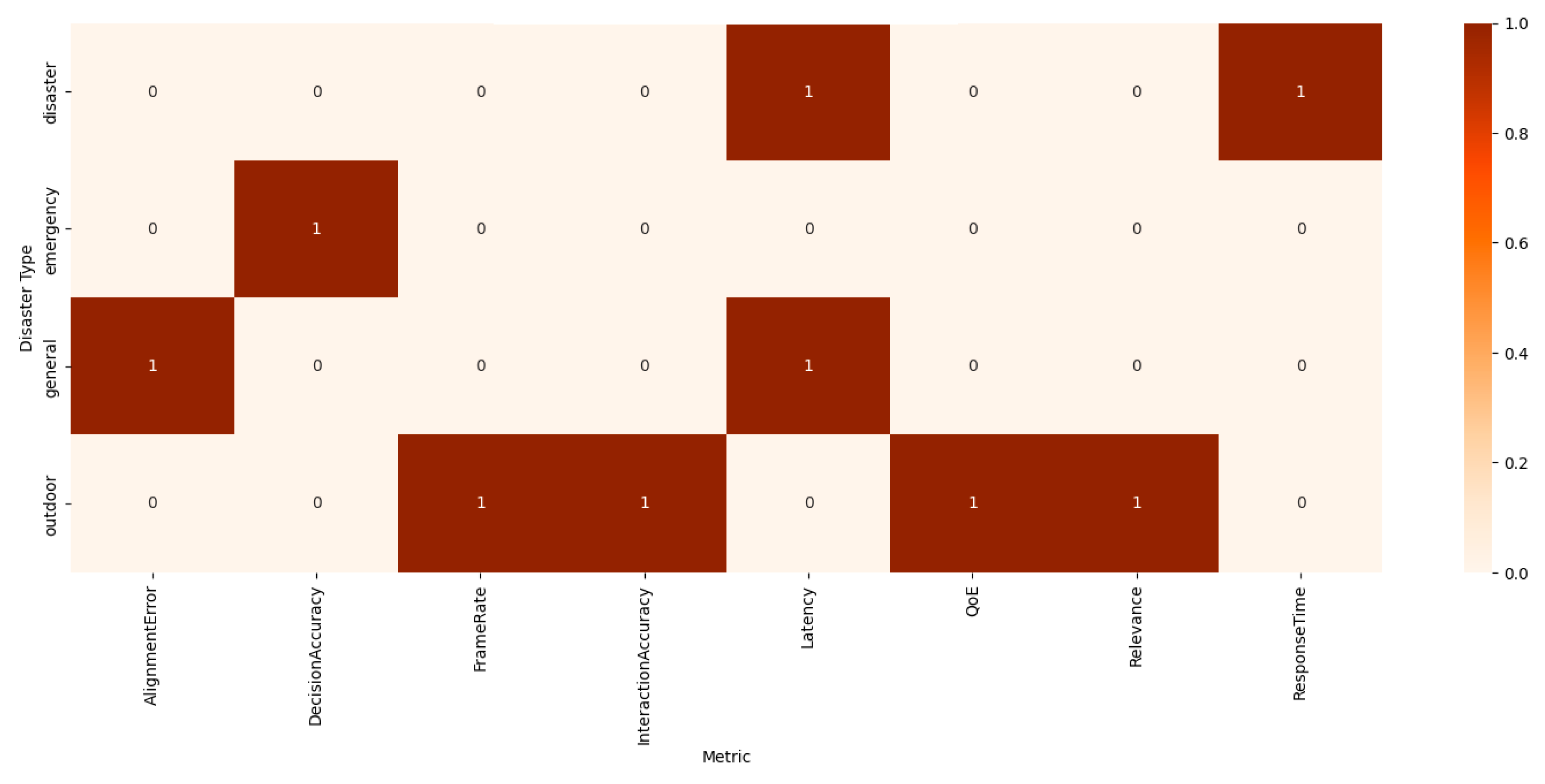
Appendix B. Evaluation Questionnaire
The questionnaire used to evaluate the RESCUE-AR framework was divided into three main dimensions: Perceived Usability (based on the standard SUS protocol), Anticipated Workload (based on the standard NASA-TLX protocol), and Concept Specific Questions. Respondents answered using a 5-point Likert scale (1: Strongly Disagree to 5: Strongly Agree for Usability/Concept; and 1: Very Low to 5: Very High for Workload).
1. Perceived Usability (System Usability Scale - SUS)
I think that I would like to use a system like RESCUE-AR frequently.
I found the RESCUE-AR concept unnecessarily complex.
I thought the RESCUE-AR concept was easy to understand.
I think that I would need the support of a technical person to be able to use a system like RESCUE-AR.
I found the various functions in RESCUE-AR were well integrated.
I thought there was too much inconsistency in the RESCUE-AR concept.
I would imagine that most people would learn to use a system like RESCUE-AR very quickly.
I found the RESCUE-AR concept very cumbersome/difficult to use.
I felt very confident using a system like RESCUE-AR effectively in an emergency context.
I needed to learn a lot of things before I could get going with a system like RESCUE-AR.
2. Anticipated Workload (NASA Task Load Index - NASA-TLX)
Mental Demand: How mentally demanding would using RESCUE-AR be?
Physical Demand: How physically demanding would using RESCUE-AR be?
Temporal Demand: How hurried or rushed would you feel when using RESCUE-AR?
Effort: How hard would you have to work to accomplish your level of performance?
Frustration: How insecure, discouraged, irritated, or stressed would you feel when using RESCUE-AR?
3. Core Concept and Operational Suitability Questions
I would trust the information provided by RESCUE-AR during emergency operations.
The combination of multiple sensors (GPS, IMU, SLAM) increases my confidence in the data accuracy.
The visual annotations in Augmented Reality would significantly improve my situational awareness in the field.
A hands-free or low-interaction operation is essential for this type of system in critical environments.
References
- Irwanto; Dianawati, R.; Lukman, I. Trends of augmented reality applications in science education: A systematic review from 2007 to 2022. Int. J. Emerg. Technol. Learn. (iJET) 2022, vol. 17(no. 13), 157–175. [Google Scholar]
- Pascoal, R. M.; de Almeida, A.; Sofia, R. C. Activity recognition in outdoor sports environments: smart data for end-users involving mobile pervasive augmented reality systems. In Adjunct Proceedings of the 2019 ACM International Joint Conference on Pervasive and Ubiquitous Computing and Proceedings of the 2019 ACM International Symposium on Wearable Computers, 2019; pp. 446–453. [Google Scholar]
- Wang, H.; Lu, K.; et al. SLAM Overview: From Single Sensor to Heterogeneous Fusion. Remote Sens. 2022, 14(23), 6033. [Google Scholar] [CrossRef]
- Irfan, M.; et al. LSAF-LSTM-Based Self-Adaptive Multi-Sensor Fusion for Robust UAV State Estimation in Challenging Environments; The UWS Academic Portal, 2025. [Google Scholar]
- Satyanarayanan, M.; Bahl, P.; Caceres, R.; Davies, N. The case for VM-based cloudlets in mobile computing. IEEE Pervasive Comput. 2009, vol. 8(no. 4), 14–23. [Google Scholar] [CrossRef]
- Siriwardhana, Y.; Porambage, P.; Liyanage, M.; Ylianttila, M. A survey on mobile augmented reality with 5G mobile edge computing: Architectures, applications, and technical aspects. IEEE Commun. Surv. Tutor. 2021, vol. 23(no. 2), 1160–1192. [Google Scholar] [CrossRef]
- Billinghurst, M.; Clark, A.; Lee, G.; et al. A survey of augmented reality. Found. Trends Human–Computer Interact. 2015, vol. 8(no. 2-3), 73–272. [Google Scholar] [CrossRef]
- Chatzopoulos, D.; Bermejo, C.; Huang, Z.; Hui, P. Mobile augmented reality survey: From where we are to where we go. IEEE Access 2017, vol. 5, 6917–6950. [Google Scholar] [CrossRef]
- Van Krevelen, D.; Poelman, R. A survey of augmented reality technologies, applications and limitations. Int. J. Virtual Real. 2010, vol. 9(no. 2), 1–20. [Google Scholar] [CrossRef]
- Cao, J.; Lam, K.-Y.; Lee, L.-H.; Liu, X.; Hui, P.; Su, X. Mobile augmented reality: User interfaces, frameworks, and intelligence. ACM Comput. Surv. 2023, vol. 55(no. 9), 1–36. [Google Scholar] [CrossRef]
- Kim, S. K.; Kang, S.-J.; Choi, Y.-J.; Choi, M.-H.; Hong, M. Augmented-reality survey: from concept to application. KSII Trans. Internet Inf. Syst. 2017, vol. 11(no. 2). [Google Scholar] [CrossRef]
- Gomes, P.; Correia, A.; et al. Mobile Augmented Reality Techniques for Emergency Response. In NOVA Research Portal / Sistemas de Informação; 2020. [Google Scholar]
- Fuentes-Pacheco, J.; Ruiz-Ascencio, J.; Rendón-Mancha, J. M. Visual simultaneous localization and mapping: a survey. Artif. Intell. Rev. 2015, vol. 43(no. 1), 55–81. [Google Scholar] [CrossRef]
- Fan, Z.; Zhang, L.; Wang, X.; Shen, Y.; Deng, F. LiDAR, IMU, and camera fusion for simultaneous localization and mapping: a systematic review. Artif. Intell. Rev. 2025, vol. 58(no. 6), 1–59. [Google Scholar] [CrossRef]
- Sharma, P.; Katrolia, J. S.; Rambach, J.; Mirbach, B.; Stricker, D.; Seiler, J. Achieving RGB-D level segmentation performance from a single ToF camera. arXiv 2023, arXiv:2306.17636. [Google Scholar]
- Yang, Y.; Chen, Z.; Liu, Y.; Li, Y.; Hu, Z.; Gou, B. Detection system for U-shaped bellows convolution pitches based on a laser line scanner. Sensors 2020, vol. 20(no. 4), 1057. [Google Scholar] [CrossRef]
- Fiala, M. ARTag, a fiducial marker system using digital techniques. 2005 IEEE Comput. Soc. Conf. Comput. Vis. Pattern Recognit. (CVPR’05) 2005, vol. 2. IEEE, 590–596. [Google Scholar] [CrossRef]
- Laconte, J.; Kasmi, A.; Aufrère, R.; Vaidis, M.; Chapuis, R. A survey of localization methods for autonomous vehicles in highway scenarios. Sensors 2021, vol. 22(no. 1), 247. [Google Scholar] [CrossRef]
- Lv, Z.; Halawani, A.; Feng, S.; Ur Réhman, S.; Li, H. Touch-less interactive augmented reality game on vision-based wearable device. Personal. Ubiquitous Comput. 2015, vol. 19(no. 3), 551–567. [Google Scholar] [CrossRef]
- Pascoal, R.; Almeida, A. D.; Sofia, R. C. Mobile pervasive augmented reality systems—MPARS: The role of user preferences in the perceived quality of experience in outdoor applications. ACM Trans. Internet Technol. (TOIT) 2020, vol. 20(no. 1), 1–17. [Google Scholar] [CrossRef]
- Pascoal, R. M.; Guerreiro, S. L. “Information overload in augmented reality: The outdoor sports environments,” in Information and Communication Overload in the Digital Age; IGI Global Scientific Publishing, 2017; pp. 271–301. [Google Scholar]
- Pascoal, R.; De Almeida, A. M.; Sofia, R. C. Reducing information overload with machine learning in mobile pervasive augmented reality systems. IEEE Access, 2025. [Google Scholar]
- Gräfe, D.; Zanganeh, T. S. T.; Schneider, J. M. View Synthesis: LiDAR Camera versus Depth Estimation. In 2021 IEEE International Conference on Image Processing (ICIP); 2021; pp. 1959–1963. [Google Scholar] [CrossRef]
- Bela, D.; Stambach, R.; Sanyal, S.; Pambala, V. D.; De, S. Mobile AR Depth Estimation: Challenges & Prospects (Extended Version). arXiv 2023, arXiv:2310.14437. [Google Scholar]
- Sun, H.; Shi, Y.; Han, H.; Li, X.; Wu, Q.; Zha, H.; Liu, Q. Survey on Monocular Metric Depth Estimation. arXiv 2025, arXiv:2501.11841. [Google Scholar]
- Pascoal, R. M.; Gómez, J. N.; Ricarte, É. EfMAR: An outdoor mobile augmented reality framework for geospatial measurements. Sensors 2026, vol. 26(no. 13), 4063. [Google Scholar] [CrossRef]
Figure 1.
Architecture of the RESCUE-AR Framework.
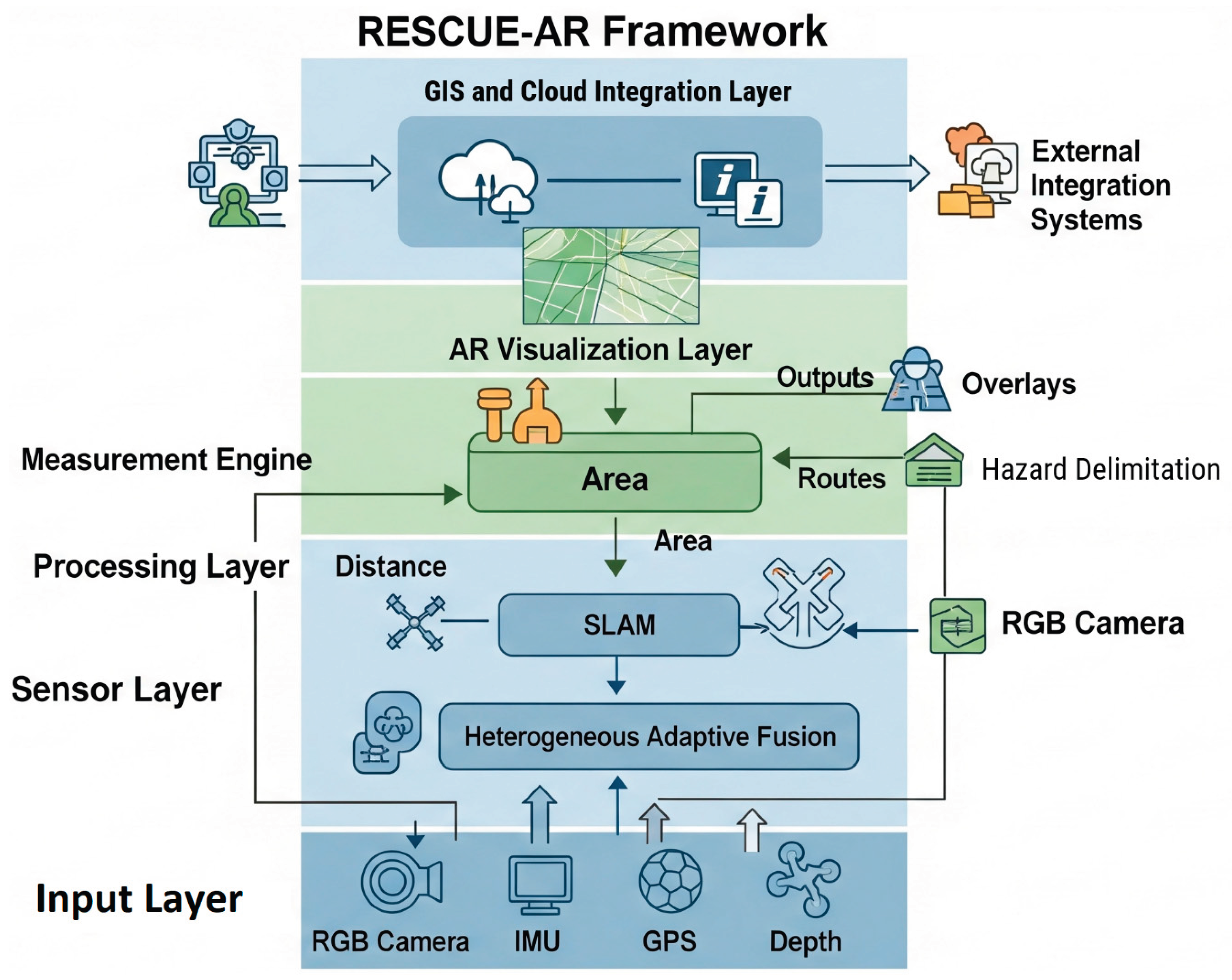
Figure 2.
Sensor-level limitations across representative disaster scenarios.
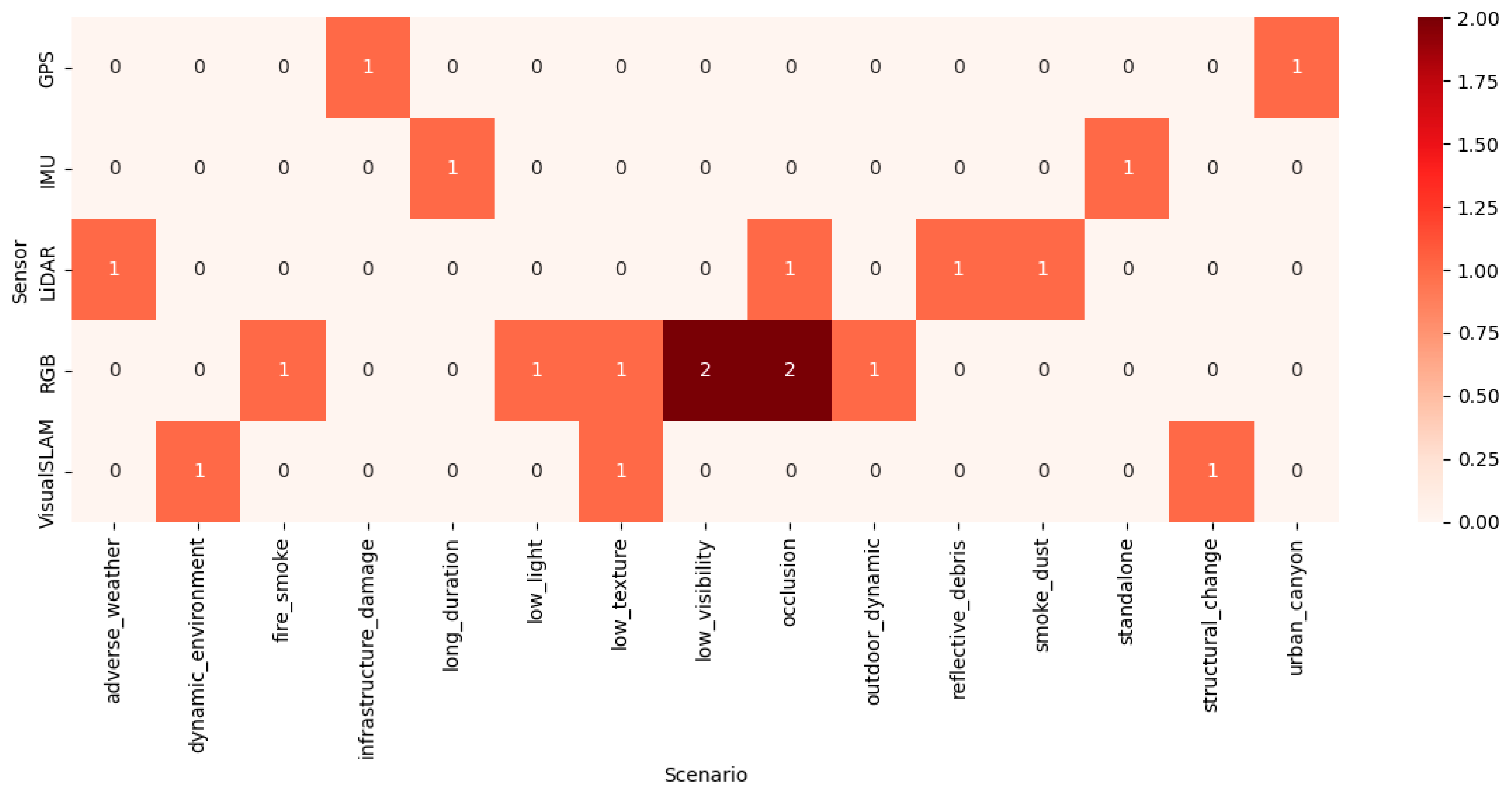
Figure 3.
Critical failures per sensor type in outdoor disaster response.
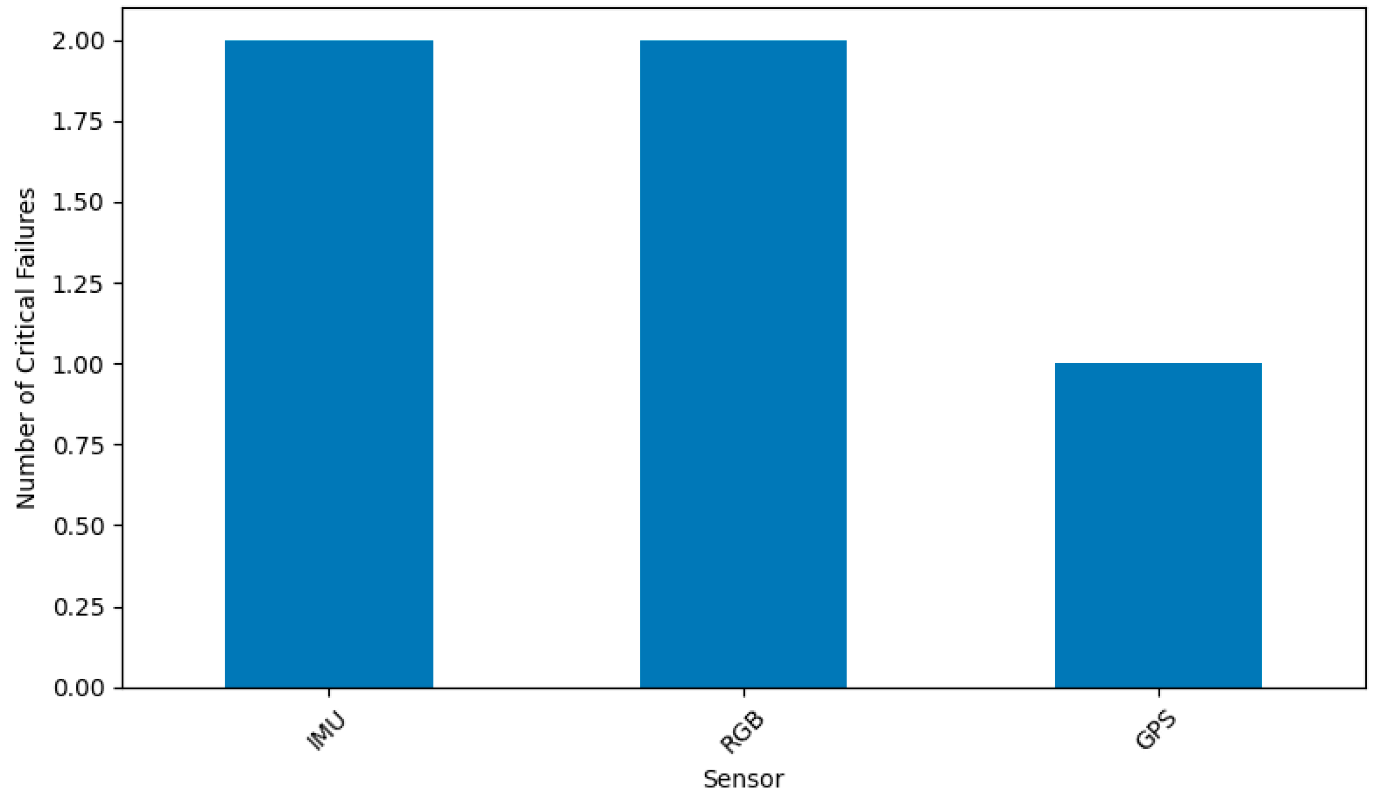
Table 1.
Evaluation of AR Measurement Technologies in Outdoor Environments.
| Technology/ Sensor |
Typical Accuracy | Robustness in Challenging Conditions (Occlusion, Smoke, etc.) | Range & Coverage | Key Limitation in Unfused Systems |
|---|---|---|---|---|
|
RGB Camera/ Visual SLAM |
High (Short-term) | Low (Fails immediately with feature scarcity, occlusion, or blur [15]) | Short to Medium | Vulnerability to Visual Occlusion/Drift |
|
IMU (Accelerometer/ Gyroscope) |
Low to Medium | High (Unaffected by visual/signal blocks) | Short to Medium | High Positional Drift over time (Integration Error) |
|
Depth Sensor (LiDAR/ ToF) |
High | Medium (Reduced performance in direct sunlight/rain/smoke) | Short (Typically <10m) |
Limited Range and Environmental Interference |
|
GPS/ GNSS |
Low (3m to 10m) | Low (Fails in urban canyons, dense cover, or denial [18]) | Long (Global) | Low Precision and Vulnerability to Denial |
Disclaimer/Publisher’s Note: The statements, opinions and data contained in all publications are solely those of the individual author(s) and contributor(s) and not of MDPI and/or the editor(s). MDPI and/or the editor(s) disclaim responsibility for any injury to people or property resulting from any ideas, methods, instructions or products referred to in the content. |
© 2026 by the authors. Licensee MDPI, Basel, Switzerland. This article is an open access article distributed under the terms and conditions of the Creative Commons Attribution (CC BY) license (http://creativecommons.org/licenses/by/4.0/).
Copyright: This open access article is published under a Creative Commons CC BY 4.0 license, which permit the free download, distribution, and reuse, provided that the author and preprint are cited in any reuse.