

Submitted:
02 September 2026
Posted:
03 September 2026
You are already at the latest version
Abstract
In many cities of the Global South, the minibus taxi industry operates as the backbone of informal or semi-formal public transport, yet its relationship with statutory spatial planning remains critically under-examined. This paper investigates how the minibus taxi sector shapes and is shaped by land-use regulation, urban form, and mobility infrastructure. Drawing on a case study of a major South African metropolitan area, the research employs a mixed-methods approach combining spatial analysis, policy review, and semi-structured interviews with taxi operators, municipal planners, and commuters. Findings reveal a persistent spatial mismatch between taxi route networks, formal land use zoning, and transport interchanges, leading to congestion, unsafe boarding points, and limited integration with land development. Furthermore, the study identifies how exclusionary planning practices historically marginalised the taxi industry, resulting in informal adaptation strategies that now complicate regulatory reform. The paper argues for a relational spatial planning framework that recognises the taxi industry as a legitimate land use and mobility actor. Policy implications include rethinking transit-oriented development, upgrading taxi ranks as multi-functional public spaces, and co-producing planning regulations with industry stakeholders. This research contributes to debates on transport-land use integration in contexts of informality and rapid urbanisation.
Keywords:
minibus taxi industry
; spatial planning
; land use–transport integration
; informal transport
; urban informality
; transit-oriented development
1. Introduction
The minibus taxi industry constitutes the lifeblood of South Africa’s urban transportation system, providing mobility to millions of commuters daily, particularly in low-income and historically marginalised communities. In 2013, minibus taxis provided two thirds of all public transport in metropolitan areas and more than one third of daily passenger trips in motorised transport (Hunter van Ryneveld, 2018). The industry transports approximately 15 million commuters daily, employs an estimated 300,000 taxi drivers and 100,000 taxi marshals, and supports the livelihoods of countless informal traders who depend on taxi rank economies (Fobosi, 2026). This makes the minibus taxi sector not merely a transport service but a fundamental pillar of South Africa’s socioeconomic fabric.
The industry’s dominance is not accidental. It emerged as a grassroots response to the failures of apartheid-era spatial planning and public transport provision. As the apartheid government systematically removed black South Africans from urban centres and relegated them to peripheral townships, the demand for affordable, accessible transport grew exponentially. The taxi industry filled this void, operating as a community-based transport solution that defied discriminatory regulations and provided a lifeline for the urban poor (Fobosi, 2019a). Today, despite the advent of formal public transport initiatives such as Bus Rapid Transit (BRT) systems, minibus taxis remain the most widely used mode of transport, particularly for short- to medium-distance journeys (Fourie, 2003).
1.1. Problem Statement: The Critical Yet Under-Examined Relationship Between the Taxi Industry and Statutory Spatial Planning
Despite the industry’s centrality to urban mobility, its relationship with statutory spatial planning remains critically under-examined. Spatial planning in South Africa, as in many post-colonial contexts, has historically been shaped by exclusionary logics that marginalised informal transport systems. As Fobosi (2019) observes, the minibus taxi industry is still regarded as informal, a rendering that can be traced back to the apartheid era and the structural laws put in place by the government, which continue in post-apartheid South Africa. This marginalisation manifests in a persistent spatial mismatch between taxi route networks, formal land use zoning, and transport interchanges.
The consequences of this mismatch are profound. Taxi ranks are frequently located on informal, unplanned sites at road intersections, in vacant spaces next to shopping malls, or along busy thoroughfares (Fobosi, 2026). These locations often lack adequate infrastructure, sanitation, and safety provisions, exposing commuters to risks and creating congestion. Moreover, the absence of formal spatial planning for taxi infrastructure means that the industry operates through informal adaptation strategies that complicate regulatory reform efforts. The National Land Transport Act of 2009 made provision for the planning and coordination of land transport, yet very little planning and coordination have been done for informal minibus taxi stations (National Taxi Alliance, 2018).
1.2. Research Aim
This paper aims to investigate how the minibus taxi sector shapes, and is shaped by, land-use regulation, urban form, and mobility infrastructure. Drawing on a case study of a major South African metropolitan area, the research seeks to understand the spatial dynamics of the taxi industry and its implications for urban planning and governance.
1.3. Key Argument
The paper argues for a relational spatial planning framework that recognises the taxi industry as a legitimate land-use and mobility actor. Such a framework would move beyond viewing minibus taxis as a ‘necessary nuisance’ (Hugo et al., 2026) and instead position them as catalysts for inclusive transit-oriented development. This requires acknowledging the industry’s historical marginalisation, understanding its informal adaptation strategies, and co-producing planning regulations with industry stakeholders.
The paper proceeds as follows. Section 2 provides a literature review and theoretical framework, examining spatial planning in the Global South, transport-land use integration, informality and urban governance, and the evolution of the minibus taxi industry. Section 3 describes the research context and methodology, including the case study selection and mixed-methods design. Section 4 presents the findings, organised around key themes of spatial mismatch, inadequate interchange points, limited integration with land development, informal adaptation strategies, and exclusionary planning practices. Section 5 discusses these findings, interpreting the mismatch, analysing the vicious cycle of marginalisation and informal adaptation, and proposing a relational spatial planning framework. Section 6 concludes with policy implications and avenues for future research.
2. Literature Review and Theoretical Framework
2.1. Spatial Planning and Land-Use Regulation in the Global South
Spatial planning in the Global South has been profoundly shaped by colonial and post-colonial legacies. As Mahendra (2017) argues, the lack of an integrated approach to transport planning is ubiquitous across relatively low-income cities of the Global South, particularly in South Asia and sub-Saharan Africa. This includes integration not only across transport modes but also crucial integration across interlinked land use, transport, and economic development sectors. In South Africa, apartheid-era spatial planning deliberately segregated populations along racial lines, creating a spatial structure characterised by peripheral townships disconnected from economic centres. This legacy continues to shape contemporary urban form and mobility patterns.
Modern transport planning in the Global South is faced with the twin challenges of addressing longstanding structural deficits in basic infrastructure and capacity for connectivity while attempting to reduce marked social, spatial, economic, and environmental inequalities (Fobosi, 2026). Conventional approaches to transport planning in developing contexts build on assumed links between infrastructure development and economic growth, with a historical focus on private motorised travel that has increased the mobility and access gaps between social groups. However, new paradigms of accessibility and sustainability have led to growing focus on harnessing transport infrastructure as a mechanism for social integration in some contexts.
Using Cape Town, as a case to present comparative evidence, as seen on Figure 1 and Figure 2 respectively, where contextual realities illustrate these areas are characterised by employment opportunities that are predominantly low skilled and labour intense. The spatial inequalities illustrated in Figure 1 and Figure 2 highlight the persistent separation between peripheral communities and areas of socio-economic opportunities. This is the reality in most South African cities. Majority of the workers within these integration zones and the areas of economic opportunities commute from previously disadvantaged places which are located within the city’s peripherals (Turok, Visagie, and Scheba, 2021); (Moyo, Zuidgeest and van Delden, 2021). The spatial distribution of formal public transport does not always adequately connect these peripherals’ residential areas with employment centre, that is the home-work separation is prevalent (Turok, Visagie, and Scheba, 2021); (Moyo, Zuidgeest and van Delden, 2021). Additionally, at times the fares paid by the commuters are exorbitant, which then leads to their disposable income being spread too thin to sustain their livelihoods. It is with these realities that most South Africans then also become captive Non-Motorised Transport (NMT) users due to economic circumstances (Vanderschuren, Newlands, and Wheeldom, 2022). Therefore, in the context on Figure 1 and Figure 2, the taxi sector adapts and plays an important role in extending transport accessibility (Cerveroa and Goluby, 2007). The flexibility of the taxi sector has enabled to bridge such gaps as similar to those illustrated in Figure 1 and Figure 2 below. The taxis are the most flexible, available, convenient and affordable mode of public transport, and serves largely the urban poor (Fobosi, 2013; TETA, 2016).
2.2. Transport-Land Use Integration: Theories and Limitations in Informal Contexts
The integration of transport and land use planning has long been a central concern of urban planning theory. Transit-oriented development (TOD), popularised by Peter Calthorpe in the 1990s, seeks to focus development around public transport stops or stations to increase accessibility and liveability while reducing urban sprawl and car dependence (Hugo et al., 2026). However, TOD has been critiqued for its applicability in contexts of informality, particularly in cities of the Global South where informal transport systems dominate.
As Hugo et al. (2026) argue, there is another form of transit-oriented development that serves the townships and informal settlements where the majority of South Africans reside. Here, minibus taxis are one of the most common forms of transport to work and school. These taxis also attract formal and informal businesses that serve their needs and those of the passengers at taxi ranks and waiting areas. This suggests that taxi ranks and stops can form the nucleus of additional economic nodes in townships and informal areas, beyond the main taxi ranks, as apartheid planning excluded business sites from the townships.
However, the potential of taxi-oriented development remains largely unrealised. As Fobosi (2019) documents, even when attempts are made to integrate taxi infrastructure into formal transport networks, the results are often exclusionary. The Indingilizi transport node in Dobsonville, Johannesburg, for example, was designed to house various transport modes and operators in one transport interchange, yet upon closer inspection, one realises that the systems are in fact not integrated. The building’s physical design is exclusionary as it is fenced off and does not integrate with its surroundings, and traders have chosen to operate outside along the street rather than in the formally built structures.
2.3. Informality and Urban Governance: The Concept of ‘Planning from Below’
The concept of ‘planning from below’ or insurgent planning has emerged as a critical framework for understanding how marginalised communities shape urban space in the absence of formal planning. As Hugo et al. (2026) observe, in the absence of genuine collaborative planning, residents often take matters into their own hands: changing streets, creating mini-parks, and setting up informal market stalls. Such tactical or guerrilla urbanism comprises bottom-up actions that are community-initiated and a response to community needs. Similarly, the taxi industry began as a bottom-up response to the transportation needs of residents in far-flung residential areas under apartheid.
This perspective challenges top-down, technocratic approaches to planning that exclude the views of the people for whom the planning is undertaken. Collaborative or communicative planning, influenced by Habermas, Foucault, and Giddens, emphasises the inclusion of communities and their views and concerns as essential in planning (Hugo et al., 2026). However, the gap between participatory ideals and practice remains significant. As Arnstein’s (1969) ‘ladder of participation’ illustrates, citizen power in planning processes is often limited to manipulation, therapy, informing, consultation, or placation, rather than genuine partnership, delegated power, or citizen control.
2.4. The Minibus Taxi Industry: From Marginalisation to Adaptation
The minibus taxi industry in South Africa has undergone a remarkable evolution. From its origins in the 1930s as a small-scale operation using sedan taxis in townships, it grew rapidly following deregulation in the late 1970s and 1980s (Barrett, 2003; Fourie, 2003). The Road Transportation Act of 1977 allowed black entrepreneurs to enter the taxi industry, leading to the introduction of ten-seater minibuses. By 1986, 16-seater vehicles were legalised for taxi use (Ingle, 2009). The industry’s growth was further fuelled by the Transport Deregulation Act of 1988, which allowed market forces to determine entry into the industry (Fourie, 2003).
Despite its growth, the industry has remained largely informal, operating within a complex web of taxi associations that regulate routes, fares, and disputes. This informality is both a source of flexibility and a source of vulnerability. On one hand, it allows the industry to respond rapidly to changing demand and to serve areas that formal transport providers cannot reach. On the other hand, it perpetuates precarious working conditions, regulatory conflicts, and instances of violence (Fobosi, 2021).
The industry’s spatial adaptation strategies are particularly significant. Taxi operators have developed sophisticated networks of informal ranks and routes that respond to passenger demand and land use patterns. As Fobosi (2026) documents, informal minibus taxi stations are located on empty pockets of vacant spaces next to malls, along road intersections, and in areas where multiple commuters congregate. This locational flexibility ensures accessibility but also poses locational disorder and complicates formal planning efforts.
The Figure 3, above establishes the institutional architecture of the South African taxi industry by illustrating a typical structure and form of the taxi sector. It depicts the five principal actors, namely the taxi owners, taxi drivers, passengers, taxi associations and regulatory authorities. There is an interrelationship of the principal actors within the industry.
Figure 4 below, visually depicts a historical summary on the emergence of the industry. With some notable events such as the Road Transportation Act of 1977; the deregulation era, which then ultimately led to the growth of permits within the taxi sector; the dire taxi wars and crimes; the establishment of the National Taxi Task Team (NTTT), and eventually the TRP/RTRP.
2.5. Theoretical Synthesis: Proposing a Relational Spatial Planning Framework
This paper proposes a relational spatial planning framework that integrates insights from transport-land use theory, informality studies, and collaborative planning. The framework is relational in three senses. First, it recognises the dynamic, mutually constitutive relationship between the taxi industry and urban space: taxis shape urban form, and urban form shapes taxi operations. Second, it acknowledges the relational nature of governance, requiring collaboration among state actors, taxi associations, operators, drivers, and commuters. Third, it situates the taxi industry within broader relations of power, history, and inequality.
A relational framework moves beyond viewing the taxi industry as a problem to be solved or a nuisance to be tolerated. Instead, it positions taxi operators as legitimate spatial actors whose knowledge and practices are essential for effective planning. This aligns with calls for a paradigm shift from viewing minibus taxis solely as a ‘necessary nuisance’ to recognising them as catalysts for inclusive transit-oriented development (Hugo et al., 2026). It also resonates with the concept of ‘people as infrastructure’ (Simone, 2004), which highlights how marginalised communities compensate for state failures through social cooperation and adaptive practices.
3. Research Context and Methodology
3.1. Case Study Selection: A Major South African Metropolitan Area
This research focuses on the City of Johannesburg, South Africa’s economic heartland and home to the most extensive minibus taxi network in the country. Johannesburg was selected for several reasons. First, it is the site of South Africa’s most complex and extensive taxi operations, with an estimated 12,300 private taxis managed by 32 short-distance taxi associations, running over 1,000 separate routes (Department of Roads and Transport, 2013). Second, Johannesburg has been at the forefront of efforts to integrate the taxi industry into formal public transport networks through initiatives such as the Rea Vaya BRT system and the Corridors of Freedom programme. Third, the city’s spatial structure, shaped by apartheid-era segregation, makes it an ideal case for examining the relationship between taxi networks and urban form.
3.2. Mixed-Methods Design
The research employs a mixed-methods design comprising three components:
3.2.1. Spatial Analysis of Taxi Route Networks vs. Formal Zoning
Spatial analysis was conducted using Geographic Information Systems (GIS) to map informal taxi stations and routes in relation to formal land use zoning in Johannesburg. Data on informal taxi stations were collected through field surveys conducted in Centurion and Midrand, areas experiencing rapid urbanisation and significant taxi activity. The analysis identified the locations of informal taxi stations, the land-use types on which they were stationed, and the gaps in taxi service provision.
3.2.2. Policy Review of Municipal Planning and Transport Documents
A comprehensive review was conducted of municipal planning and transport documents, including the City of Johannesburg’s Integrated Development Plan, Spatial Development Framework, and Integrated Transport Plan. The review examined the extent to which these documents address the minibus taxi industry, how they conceptualise its role, and what provisions they make for taxi infrastructure and services.
3.2.3. Semi-Structured Interviews
Semi-structured interviews were conducted with three key stakeholder groups: taxi operators (owners, drivers, and marshals), municipal planners and transport officials, and commuters. Interviews explored perceptions of spatial planning for taxi infrastructure, experiences of taxi ranks and routes, and views on integration with other transport modes. A total of 102 interviews were conducted across two phases of research: 44 interviews in East London and Mdantsane in 2012-2013, and 58 interviews in Johannesburg in 2018-2020 (Fobosi, 2021). Ethical approval was obtained from the University of Johannesburg (REC-02-156-2017) and Rhodes University Faculty of Humanities Higher Degrees Committee. Due to participants’ constant mobility and documented industry intimidation, verbal informed consent was obtained after full explanation of research purposes, risks, and confidentiality protections. A secure consent log was maintained separately from data. All names are pseudonyms; locations are identified only by city and role.
3.3. Data Collection and Sampling Strategy
Sampling was purposive. Participants were recruited through taxi associations, rank-based snowballing, and direct approach at ranks during off-peak hours. Inclusion criteria required minimum six months’ experience in the industry. The final sample comprised taxi drivers, taxi marshals, taxi owners, and key informants including government officials, trade union representatives, and industry body officials.
Participant observation was conducted at four Johannesburg taxi ranks (Wanderers, Noord, Faraday, Bree) and three East London ranks, involving 45 hours of observation documenting daily routines, interactions between marshals and drivers, and negotiation of rank access. Additionally, documentary analysis examined TRP policy documents, RTRP frameworks, Department of Transport annual reports, and Competition Commission inquiry transcripts.
3.4. Data Analysis Procedures
Data analysis followed a thematic analysis approach. Interviews were transcribed and coded using ATLAS.ti software. Codes were clustered into potential themes, iteratively refined through comparison with theoretical concepts. Analysis was both inductive, allowing themes to emerge from data, and deductive, interrogating data through theoretical lenses. Spatial data were analysed using GIS software to map taxi stations and routes in relation to land use zoning.
3.5. Ethical Considerations and Researcher Positionality
Ethical approval was obtained from the University of Johannesburg and Rhodes University. Due to participants’ constant mobility and documented industry intimidation, verbal informed consent was obtained after full explanation of research purposes, risks, and confidentiality protections. All names are pseudonyms; locations are identified only by city and role.
As a black South African researcher conversant in participants’ home languages, the researcher occupied an ‘insider-outsider’ position: insider through shared linguistic and racialised experience of South African spatial inequality; outsider through academic location and non-participation in daily rank labour. Reflexive field notes documented how this positionality shaped data collection, including moments when participants tested trustworthiness through questions about research benefits and potential repercussions (Fobosi, 2021).
4. Findings
4.1. Spatial Mismatch Between Taxi Routes and Formal Land-Use Zoning
The spatial analysis revealed a significant mismatch between taxi route networks and formal land-use zoning. As Fobosi (2026) documents, informal minibus taxi stations are frequently located on land-use zones that were not designated for transport infrastructure. These include vacant spaces next to shopping malls, road intersections, and areas adjacent to commercial land uses. The research found 50 informal minibus taxi stations within the study area of Centurion and Midrand, none of which corresponded to formal zoning provisions for taxi infrastructure.
This mismatch reflects a broader failure of spatial planning to accommodate the taxi industry. As the National Taxi Alliance (2018) noted, the taxi industry is a victim of government failures at the local level to produce transport plans and integrated public transport network plans. The National Land Transport Act made provision for planning and coordination of land transport, but very little planning and coordination were done for informal minibus taxi stations. Interview participants confirmed this finding. One taxi owner from Wanderers Taxi Rank stated:
“The city planners, they don’t think about us. They plan for the buses, the trains, the BRT. But we are the ones who carry most people. They put the ranks in bad places, or they don’t put them at all. Then they complain when we stop on the road.” (Taxi Owner 1, Wanderers Taxi Rank, Interview, November 2018)
This spatial mismatch has significant consequences. Taxis operating from informal ranks often stop in ways that disrupt traffic flow, creating congestion and safety hazards. Passengers must navigate unsafe boarding points, particularly during peak hours when ranks are overcrowded. The absence of formal rank infrastructure also means that passengers are exposed to weather conditions, crime, and other risks.
4.2. Inadequate and Unsafe Interchange Points: Congestion and Commuter Risk
The research documented widespread inadequacy of taxi interchange points. Many taxi ranks lack basic infrastructure such as shelters, seating, ablution facilities, and security. As one taxi marshal from Bree Street Taxi Rank explained:
“The condition of the rank is not good, because when it rains, it gets flooded at the taxi rank, and then people are unable to board the taxis and go to the taxi rank. When these cars unload the other taxis cannot get out because there is only one entrance. The other one is that there are no cameras here.” (Taxi Marshal, Bree Street Taxi Rank, Interview, August 2018)
The absence of security infrastructure perpetuates precarious conditions in taxi ranks. A taxi owner from Wanderers Taxi Rank described the risks:
“There’s a lot of thugs here. It’s those that smoke Nyaope, and they rob people. And if you hit them, they arrest you.” (Taxi Owner 2, Wanderers Taxi Rank, Interview, November 2018)
The inadequacy of interchange points also contributes to congestion. Taxi operators often stop anywhere along the streets because there are no dedicated spaces for loading and unloading. This creates traffic bottlenecks, particularly in commercial areas where passenger demand is highest. One taxi driver from Bree Street Taxi Rank noted:
“When these cars unload the other taxis cannot get out because there is only one entrance. The other one is that there are no cameras here.” (Taxi Driver 2, Bree Street Taxi Rank, Interview, August 2018)
Through the lens of road safety, due to the absence of subsidies within the taxi sector, there is created pressure for the taxi operators to generate revenue (Asimeng and Asabere, 2022). In turn this contributes to behaviours such as over speeding, overloading and dangerous overtaking (Asimeng and Asabere, 2022). Consequently, such behaviour and revenue-driven practices have important implications for road safety, as they increase the risk of road traffic crashes and potentially fatal outcomes for passengers, drivers and other road users (Akpa, Booysen, and Sinclair, 2019). In the South African context, taxis have been associated with speed-related road fatalities, associated with overloading and high-risk driving behaviour identified as contributing concerns (Akpa, Booysen, and Sinclair, 2019). Most of these concerns stem from unintended consequences, around unpredictable services, fare insecurity, and financial pressures (Randall, 2023).
4.3. Limited Integration Between Taxi Networks and Land Development
The research found limited integration between taxi networks and land development. As the Department of Development Planning (2016) of the City of Johannesburg noted, there is a strategy to improve connections through the promotion of new public transport facilities, promoting modal integration and better management of minibus taxis. However, implementation has been limited.
The lack of integration is particularly evident in the planning of new commercial developments. Priorities should be given to shopping malls, with consideration given to the reservation of space for minibus taxi stations when shopping malls are planned and developed. Yet, interviews with municipal planners revealed that such provisions are rarely made. One planner admitted:
“When a new mall is proposed, we look at traffic impact, parking, access roads. But we don’t always think about taxi ranks. The developer is more interested in parking spaces for cars. Taxis are seen as someone else’s problem.” (Municipal Planner, Interview, September 2018)
This lack of integration has consequences for both the taxi industry and urban development. Taxi operators must find informal spaces near commercial developments, often creating congestion and safety hazards. Commuters must navigate from taxis to shopping centres through unsafe environments. And commercial developments lose the economic benefits that taxi-generated foot traffic could bring.
4.4. Informal Adaptation Strategies by Taxi Operators
In the absence of formal planning provisions, taxi operators have developed sophisticated informal adaptation strategies. Informal taxi stations are located based on passenger demand rather than formal zoning. Taxi operators identify locations where commuters congregate – shopping malls, hospitals, clinics, office parks, churches, recreational facilities, and residential areas – and establish informal ranks at these locations.
These adaptation strategies are both a response to and a driver of spatial patterns. As one taxi driver from Faraday Taxi Rank explained:
“We go where the people are. If there is a new mall, we go there. If there is a new township, we go there. The planners don’t tell us where to go; the passengers tell us.” (Taxi Driver, Faraday Taxi Rank, Interview, September 2018)
This demand-responsive approach ensures that taxi services remain accessible to commuters, but it also creates challenges for planning. Informal ranks are often located in sites that are not designed for transport, leading to congestion, safety hazards, and conflicts with other land uses. Moreover, the informality of these ranks makes them difficult to regulate, monitor, or upgrade.
The taxi industry’s adaptation strategies extend beyond location to include route management. Taxi associations control route allocations, often in ways that respond to changes in land use and passenger demand. As the Competition Commission (2020) found, taxi associations regulate routes, fares, and disputes through informal governance structures that operate outside formal legal frameworks. This self-regulation ensures flexibility but also perpetuates informality and complicates formalisation efforts.
4.5. Exclusionary Planning Practices: Historical Marginalisation of the Taxi Industry
The spatial mismatch, inadequate interchange points, and limited integration documented above are not accidental. They reflect a history of exclusionary planning practices that marginalised the taxi industry. The rendering of the minibus taxi industry as informal can be traced back to the apartheid era and the structural laws put in place by the government, which are still continued in post-apartheid South Africa.
The legacy of apartheid spatial planning is central to understanding this marginalisation. The apartheid government deliberately segregated populations, creating peripheral townships that were poorly connected to economic centres. Public transport was designed primarily to move labour from townships to workplaces, with little provision for other trips. Taxis emerged as a grassroots response to these failures, but they were never integrated into formal planning frameworks.
Post-apartheid planning has perpetuated this marginalisation. As one taxi owner from Wanderers Taxi Rank explained:
“They talk about integrated transport, about the Corridors of Freedom. But we are not free. We are still pushed to the edges, told where we can stop, where we can’t. The BRT gets the new buses, the new stations. We get the old permits, the old problems.” (Taxi Owner, Wanderers Taxi Rank, Interview, November 2018)
This perception is supported by the evidence. As the National Taxi Alliance (2018) noted, the taxi industry is a victim of government failures at the local level to produce transport plans and integrated public transport network plans. The Integrated Public Transport Network plan released in January 2018 stipulated that all modes of transport in South Africa should become integrated, but implementation has been uneven.
The exclusionary practices have consequences beyond the taxi industry. They perpetuate spatial inequalities by ensuring that the primary mode of transport for the urban poor remains marginalised in planning. They undermine the potential of taxi ranks to serve as economic nodes, limiting opportunities for informal traders and other businesses that depend on taxi-generated foot traffic. And they complicate regulatory reform by entrenching informal practices that are difficult to formalise.
5. Discussion
5.1. Interpreting the Mismatch: How Informal Transport Rewrites Formal Plans
The spatial mismatch documented in this research reveals a fundamental tension between formal planning and informal practice. Taxi networks, shaped by passenger demand and operator adaptation, systematically diverge from formal zoning provisions. This is not simply a failure of enforcement or a temporary gap in planning; it reflects a deeper conflict between two ways of organising urban space.
Formal planning operates through zoning, regulation, and infrastructure investment. It is hierarchical, systematic, and forward-looking. Informal adaptation operates through trial and error, demand response, and collective action. It is flexible, opportunistic, and present-oriented. The taxi industry embodies the latter approach, organising space through networks of informal ranks and routes that respond to the rhythms of urban life.
This is not to suggest that informal adaptation is inherently superior. It has clear costs: congestion, safety hazards, and regulatory complexity. But it also has advantages: accessibility, flexibility, and responsiveness. As one municipal planner acknowledged:
“The taxis go where the buses can’t. They fill the gaps. If we are honest, they serve the people better than we do in many cases. But they also make our job harder because they don’t follow the rules.” (Municipal Planner, Interview, September 2018)
This tension between formal planning and informal adaptation is characteristic of cities of the Global South. As Hugo et al. (2026) argue, informal transport operations have evolved to meet the needs of residents in areas underserved by public transport. The poor quality of formal public transport services, along with the rigidity of their routes, makes them unattractive for residents, leading to the proliferation of informal paratransit operations.
5.2. The Vicious Cycle: Marginalisation → Informal Adaptation → Regulatory Complexity
The relationship between the taxi industry and spatial planning is characterised by a vicious cycle. Historical marginalisation by planners led to the emergence of informal adaptation strategies by taxi operators. These informal strategies, while ensuring service provision, complicated regulatory reform efforts. The resulting regulatory complexity reinforced marginalisation, as planners struggled to accommodate an industry that did not fit their frameworks.
This cycle is evident in the history of state interventions in the taxi industry. The Taxi Recapitalisation Programme (TRP), introduced in 1999, aimed to formalise the industry by replacing old vehicles with new ones. However, the programme’s exclusive focus on vehicle modernisation, while ignoring labour conditions and spatial planning, reinforced inequalities (Fobosi, 2026). As one taxi driver from Johannesburg articulated:
“The owner got R124,000 from government to scrap his old taxi. He bought a new Quantum with a loan. Now I drive a beautiful taxi. But I still pay daily target. I still have no contract. The taxi is new; my life is the same.” (Taxi Driver, Johannesburg, 2019)
The TRP’s exclusionary design – which prioritised vehicle owners over workers and offered no provisions for spatial planning – deepened the cycle of marginalisation and informal adaptation. Without proper planning for taxi ranks and routes, the industry’s informal practices continued, complicating further efforts at formalisation.
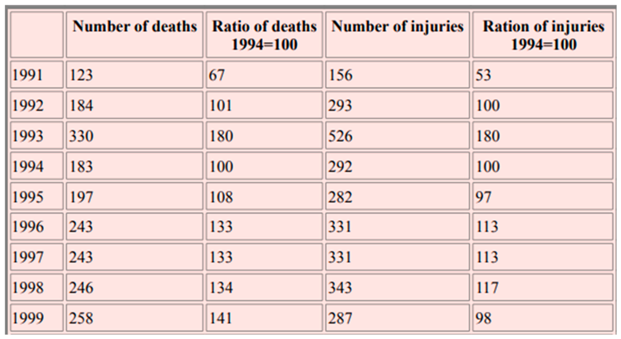
Additionally, as evident by the escalating taxi deaths and injuries numbers on Figure 5 below, the state was motivated to intervene and eradicate these social ills, through formalisation and regulatory. Which therefore sees the subsequent formation of the National Taxi Task Team in efforts to achieve harmony.
5.3. Rethinking Transit-Oriented Development (TOD) in Contexts of Informality
The findings of this research challenge conventional conceptions of transit-oriented development (TOD). TOD as traditionally conceived focuses on high-capacity, fixed-route systems such as rail and BRT. It assumes a level of formalisation, regulation, and predictability that is absent in informal transport systems. In South African cities, where minibus taxis carry the majority of commuters, this conception is inadequate.
Instead, this research suggests the need for a different conception of TOD – one that recognises the potential of taxi-oriented development. As Hugo et al. (2026) argue, taxi ranks create economic nodes that attract small businesses and have the potential to serve as prime locations for services such as clinics and schools. Yet such opportunities are seldom exploited in mandatory provincial and municipal spatial development frameworks.
A taxi-oriented development approach would involve upgrading taxi ranks as multi-functional public spaces that provide not only transport services but also economic and social infrastructure. This could include formalising informal trading, providing ablution facilities, installing security infrastructure, and integrating taxi ranks with other community facilities. Such an approach would recognise the taxi industry as a legitimate land-use and mobility actor, rather than viewing it as a problem to be solved.
In Tshwane and in Cape Town, empirical evidence and findings show that taxis can function as complementary components of the integrated system. These two cases showcase that for modal integration and formal public transportation to be effective; the taxis do not have to disappear. In the case of Tshwane, South Africa, when Gautrain and the A Re Yeng Bus Rapid Transit were implemented, the taxis served as feeders (Mokoma and Venter, 2023). Whilst in Cape Town, although the Comprehensive Integrated Transport Plan (CITP) 2023-2028 stipulated that the phase 1 of MyCiti implementation envisioned that “the minibus taxi industry would entirely be replaced by scheduled MyCiti services” (City of Cape Town, 2024). This never happened due to financial limitations and constraints. The City then proceeded to implement a different model which was hybrid. The model integrated taxis and they filled gaps in MyCiti coverage and provided feeder services to MyCiti (City of Cape Town, 2024).
Tshwane and Cape Town point out that adaptation allows taxis to remain essential to urban mobility. Cities might have to rethink and align, by developing hybrid systems in which formal and the informal sector services co-exist and complement one another (Mokoma and Venter, 2023).
5.4. Towards Co-Production: Recognising Taxi Operators as Legitimate Spatial Actors
Breaking the vicious cycle of marginalisation, informal adaptation, and regulatory complexity requires a fundamental shift in how planners relate to the taxi industry. This shift involves recognising taxi operators as legitimate spatial actors whose knowledge and practices are essential for effective planning.
This recognition aligns with calls for collaborative or communicative planning (Hugo et al., 2026). As Sherry Arnstein’s (1969) ‘ladder of participation’ illustrates, genuine citizen power requires more than informing or consultation; it requires partnership, delegated power, and citizen control. In the context of the taxi industry, this means involving taxi operators, drivers, and marshals in planning decisions that affect them.
Such involvement could take various forms. It could include the establishment of formal consultation mechanisms that bring together taxi associations, municipal planners, and other stakeholders. It could involve co-designing planning regulations that reflect the realities of taxi operations while addressing safety and regulatory concerns. And it could include capacity-building initiatives that enable taxi operators to participate effectively in planning processes.
As one taxi owner from Wanderers Taxi Rank suggested:
“We need to have political will to drive the whole regime of public transport, particularly in the taxi industry, where you deliberately come up with standardised procedures, in terms of how the business should be run. And of course you can’t do it without them, you have to do it in full consultation with them. When you talk with these people in meetings, you can see that these are sound people and once you fully engage them as government, you can have a good return on investment.” (Taxi Owner 2, Wanderers Taxi Rank, Interview, November 2018).
Using the Case of Two Rivers Urban Park (TRUP), in Cape Town to demonstrate comparative evidence around the disconnect between formal policy frameworks and the operational realities of the taxi sector, Sikundla and Vanderschuren (2025) on their work done on NMT’s policy and TRUP. They state that whilst the National Land Transport Strategic Framework (NLTSF) (2017-2022), defined by the National Land Transport Act (NLTA), 2009 (Act No.5 of 2009) guides land transport planning in South Africa (Department of Transport, 2017). At the core of the NLTSF is the recognition of the development of integrated efficient transport systems premised on the principle of sustainability (Department of Transport, 2017). To achieve this sustainability outcome the NLTSF should amongst other functions encourage the coordination and integration of transport nationally and provide clarity and certainty about planning priorities (Department of Transport, 2017). The framework seeks to encourage integrated land-use and transport planning to enable positive outcomes (Department of Transport, 2017).
As a result, although there has been a rise and a progressive shift towards giving priority to public transport, there is still misalignment with the taxi industry. Evidence gathered from the TRUP study shows that alignment of transport policies and implementation is very weak. For instance, NMT policies, and Integrated Public Transport Network were misaligned and did not give any provision to modal integration including that of the taxi sector. However, whilst findings showed that majority of people who worked within TRUP would commute and used taxis to travel to the precinct, there was no modal integration and infrastructure provision for the taxi drivers and operators within the area (Sikundla and Vanderschuren, 2025).
5.5. Implications for a Relational Spatial Planning Framework
The findings of this research support the relational spatial planning framework proposed earlier. Such a framework has several key implications:
First, it requires planners to recognise the dynamic, mutually constitutive relationship between the taxi industry and urban space. Taxis do not simply respond to urban form; they actively shape it by establishing ranks, generating foot traffic, and influencing land use. Planning must account for this active shaping role.
Second, it requires planners to engage with the relational nature of taxi governance. The taxi industry is not a monolithic entity but a complex network of associations, owners, drivers, marshals, and other actors. Effective planning must engage with this complexity, recognising the multiple interests and perspectives involved.
Third, it requires planners to situate the taxi industry within broader relations of power, history, and inequality. The industry’s informality is not simply a technical problem but a product of historical marginalisation and ongoing exclusion. Addressing this requires not just technical fixes but political engagement.
6. Conclusion and Policy Implications
6.1. Summary of Key Findings
This paper has investigated the relationship between the minibus taxi industry and spatial planning in South African cities. The research reveals a persistent spatial mismatch between taxi route networks and formal land-use zoning, leading to congestion, unsafe boarding points, and limited integration with land development. It identifies how exclusionary planning practices have historically marginalised the taxi industry, resulting in informal adaptation strategies that now complicate regulatory reform. The paper argues for a relational spatial planning framework that recognises the taxi industry as a legitimate land-use and mobility actor.
6.2. Contribution to Debates on Transport-Land Use Integration
This research contributes to debates on transport-land use integration in several ways. First, it demonstrates the limitations of conventional TOD approaches in contexts of informality, highlighting the need for alternative frameworks that recognise the role of informal transport. Second, it provides empirical evidence of the spatial consequences of excluding informal transport from planning frameworks. Third, it offers a relational framework that integrates insights from transport planning, informality studies, and collaborative governance.
6.3. Policy Recommendations
Based on the findings, several policy recommendations emerge:
6.3.1. Upgrading Taxi Ranks as Multi-Functional Public Spaces
Taxi ranks should be upgraded as multi-functional public spaces that provide not only transport services but also economic and social infrastructure. This could include formalising informal trading, providing ablution facilities, installing security infrastructure, and integrating taxi ranks with other community facilities. Such upgrades would recognise the taxi industry as a legitimate land-use and mobility actor and would harness its potential to generate economic and social benefits.
6.3.2. Co-Producing Planning Regulations with Industry Stakeholders
Planning regulations for the taxi industry should be co-produced with industry stakeholders, including taxi associations, operators, drivers, and marshals. This would involve establishing formal consultation mechanisms, co-designing planning regulations that reflect the realities of taxi operations, and building capacity for effective participation. Such co-production would enhance the legitimacy and effectiveness of regulations while recognising the industry’s agency.
6.3.3. Revising Zoning Laws to Accommodate Informal Transport Nodes
Zoning laws should be revised to accommodate informal transport nodes, including taxi ranks and stops. This would involve designating taxi ranks as legitimate land uses, providing for their location in commercial and residential areas, and establishing standards for their design and operation. Such revision would reduce the spatial mismatch between taxi networks and formal zoning, improving safety and accessibility while facilitating regulation.
6.4. Limitations of the Study
This research has several limitations. First, the case study focus on Johannesburg limits generalisability to other South African cities, where taxi industries may operate differently. Second, the research was conducted primarily in urban areas, with limited attention to rural taxi operations. Third, the research focused primarily on the perspectives of taxi operators, with less attention to the perspectives of planners and policymakers. Future research should address these limitations by comparing multiple cities, including rural areas, and exploring the perspectives of planners and policymakers more systematically.
6.5. Avenues for Future Research
Future research should explore several avenues. First, comparative studies of taxi industries and spatial planning in different South African cities would help identify common patterns and local variations. Second, longitudinal studies of taxi networks and land use would help understand how the relationship between taxis and space evolves over time. Third, action research that involves taxi operators and planners in co-producing planning solutions would test the feasibility and effectiveness of collaborative approaches. Fourth, research on the relationship between taxi spatiality and other dimensions of precarity – labour conditions, governance, and violence – would provide a more comprehensive understanding of the industry’s challenges and opportunities.
References
- Akpa, N.A. E. E., Booysen, M.J, and Sinclair, M. (2019). A comparative evaluation of the impact of average speed enforcement (ASE) on passenger and minibus taxi vehicle drivers on the R61 in South Africa.
- Arnstein, S. R. (1969) ‘A ladder of citizen participation’, Journal of the American Institute of Planners, 35(4), pp. 216-224.
- Asimeng, E. T., and Asabere, S. B. (2022). Factors that determine paratransit drivers’ willingness to participate in formal bus services in an African city.
- Barrett, J. (2003) Organizing in the Informal Economy: A Case Study of the Minibus Taxi Industry in South Africa. SEED Working Paper 39. Geneva: International Labour Organisation.
- Cerveroa, R and Goluby, A. (2007) Informal transport: A global perspective.
- City of Cape Town. (2024). Comprehensive Integrated Transport Plan (CITP) 2023-2028: 2024 Annual Update.
- Competition Commission (2020) Market Inquiry into Land Based Public Passenger Transport. Pretoria: Competition Commission South Africa.
- Department of Development Planning (2016) City of Johannesburg Integrated Development Plan. Johannesburg: City of Johannesburg Metropolitan Municipality.
- Department of Roads and Transport (2013) Gauteng 25-Year Integrated Transport Master Plan. Johannesburg: Gauteng Provincial Government.
- Department of Transport. 2017. National Land Transport Act, 2009 (ACT NO. 5 OF 2009). National Land Transport Strategic Framework (NLTSF).
- Dugard, J. (2021). From Low Intensity War to Mafia War: Taxi violence in South Africa (1987 - 2000).
- Fobosi, S. C. (2019a) ‘Employment practices within the minibus taxi industry in Johannesburg’, African Sociological Review, 23(2), pp. 103-124.
- Fobosi, S. C. (2019b) ‘Regulated set against unregulated minibus taxi industry in Johannesburg, South Africa - A contested terrain: Precariousness in the making’, World Journal of Social Science Research, 6(3), p. 303.
- Fobosi, S. C. (2021) ‘The Impact of Taxi Recapitalisation Programme on Precarious Working Conditions within the Minibus Taxi Industry in Johannesburg’. PhD Thesis. University of Johannesburg.
- Fobosi, S.C. 2026. A Fork in the Road?: The Formalisation of South Africa’s Minibus Taxi Industry. Stellenbosch: AFRICAN SUN MeDIA. Available at: https://doi.org/10.52779/9781998951789.
- Fourie, L. J. (2003) ‘Rethinking the formalisation of the minibus-taxi industry in South Africa’. MA Thesis. University of Pretoria.
- Hugo, M., Nela, V. and Bhanye, J. (2026) ‘The quest for inclusive transit-oriented development in Mangaung, South Africa’, Planning Practice & Research. [CrossRef]
- Hunter van Ryneveld, P. (2018) Urban Transport Analysis for the Urbanisation Review. Pretoria: Department of Transport.
- Ingle, M. (2009) ‘An historical overview of problems associated with the formalization of the South African minibus taxi industry’, New Contree, 57, pp. 71-87.
- Mahendra, A. (2017) ‘Balancing accessibility with aspiration: Challenges in urban transport planning in the Global South’, in Routledge Handbook of Urban Planning in Africa. London: Routledge.
- Mokoma, L. and Venter, C. (2023). Pathways to integrating paratransit and formal public transport: Case studies from Tshwane, South Africa.
- Moyo, H.T.T., Zuidgeest, M., and van Delden. (2021). Lessons Learned from Applying an Integrated Land Use Transport Planning Model to Address Issues of Social and Economic Exclusion of Marginalised Groups: The Case of Cape Town, South Africa.
- National Taxi Alliance (2018) Submission to the Competition Commission Market Inquiry into Land Based Public Passenger Transport. Pretoria: National Taxi Alliance.
- Nelson, R. J. (2021). The spatial and social logic of the Minibus Taxi network: how access may support social inclusion in Cape Town, South Africa.
- Randall, L., et al., (2023). Active travel and paratransit use in African cities: Mixed-method systematic review and meta-ethnography.
- Sikundla, J and Vanderschuren, M. (2026). Towards A More Integrated, Accessible and Safer Non-motorised Transport System for The Two Rivers Urban Park. Available: 44th Southern African Transport Conference.
- Simone, A. (2004) ‘People as infrastructure: Intersecting fragments in Johannesburg’, Public Culture, 16(3), pp. 407-429.
- Transport Education Training Authority (TETA). (2014). Sector Skills Plan Update.
- Turok, I., Visagie, J., and Scheba, A. (2021). Urban Socio-Economic Segregation and Income Inequality.
- Vanderschuren, M., Newlands, A., and Wheeldon, A. 2022. Improving Non-Motorized Transportation Provision in a Socially Inclusive Way‒ the Case of Cape Town.
Figure 1.
Comparative Evidence: Cape Town’s uneven development. (Source: Turok, Visagie, and Scheba, 2021).
Figure 1.
Comparative Evidence: Cape Town’s uneven development. (Source: Turok, Visagie, and Scheba, 2021).
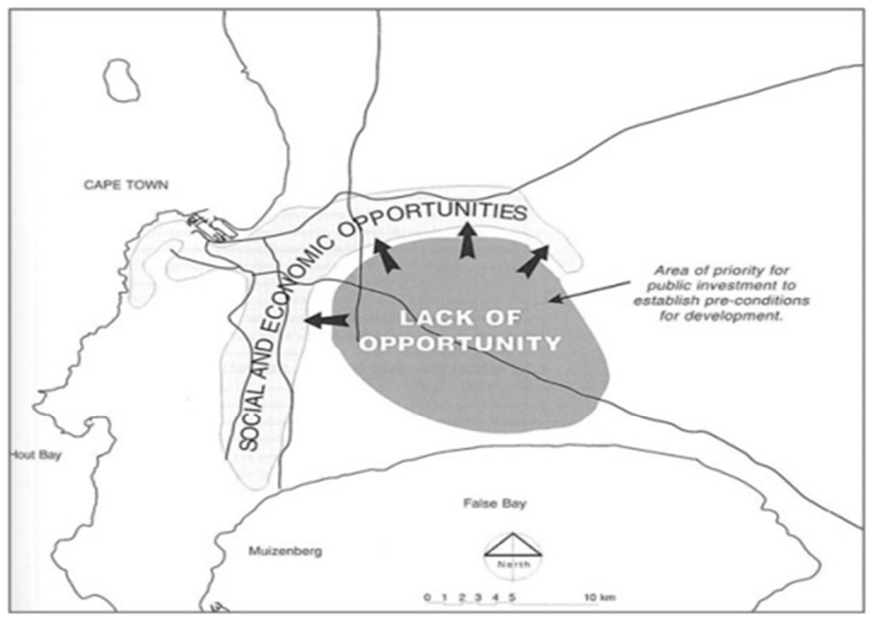
Figure 2.
Comparative Evidence: Metro South- East Integration Zone in Cape Town (Source: Moyo, Zuidgeest & van Delden, 2021).
Figure 2.
Comparative Evidence: Metro South- East Integration Zone in Cape Town (Source: Moyo, Zuidgeest & van Delden, 2021).
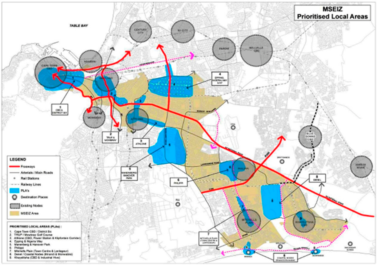
Figure 3.
Organisational structure of Minibus Taxi Industry in South Africa. Source (Nelson, 2021).
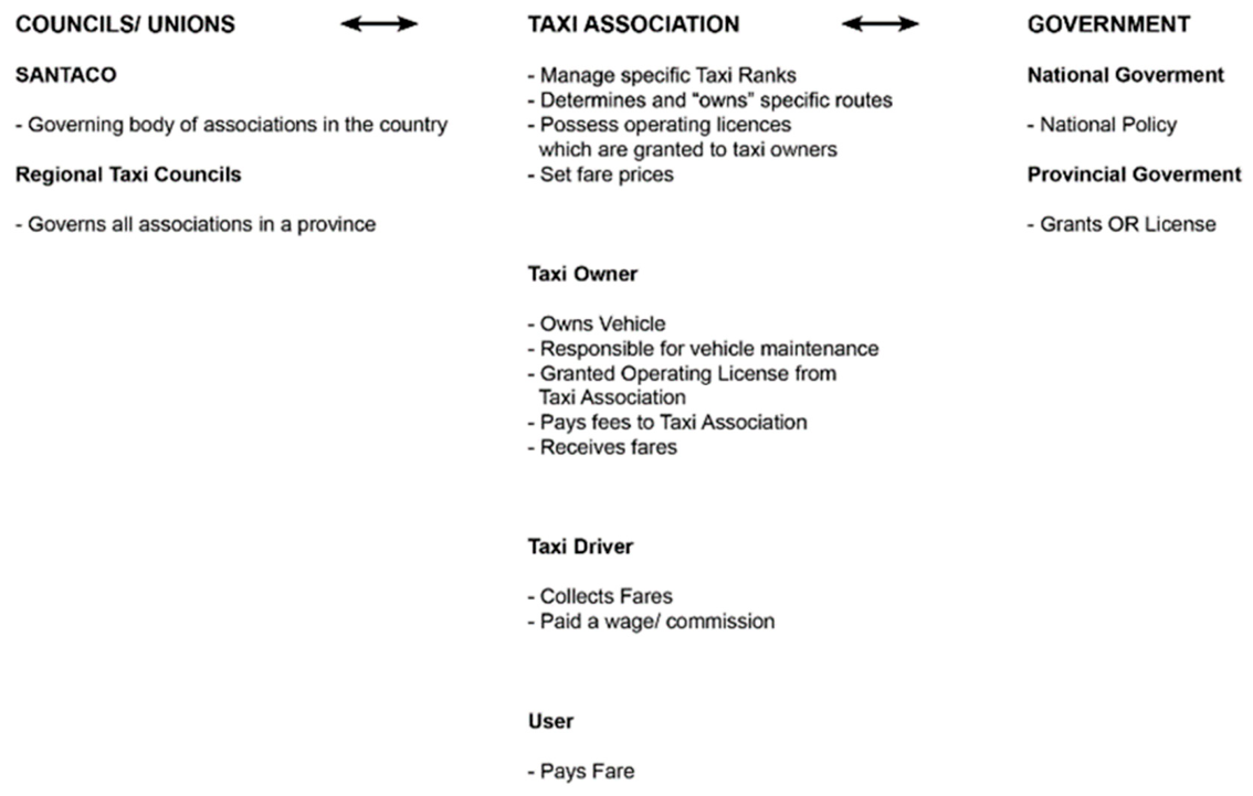
Figure 4.
Summary of the historical events in the development of South Africa’s minibus taxi industry. (Source: Fobosi, 2026).
Figure 4.
Summary of the historical events in the development of South Africa’s minibus taxi industry. (Source: Fobosi, 2026).
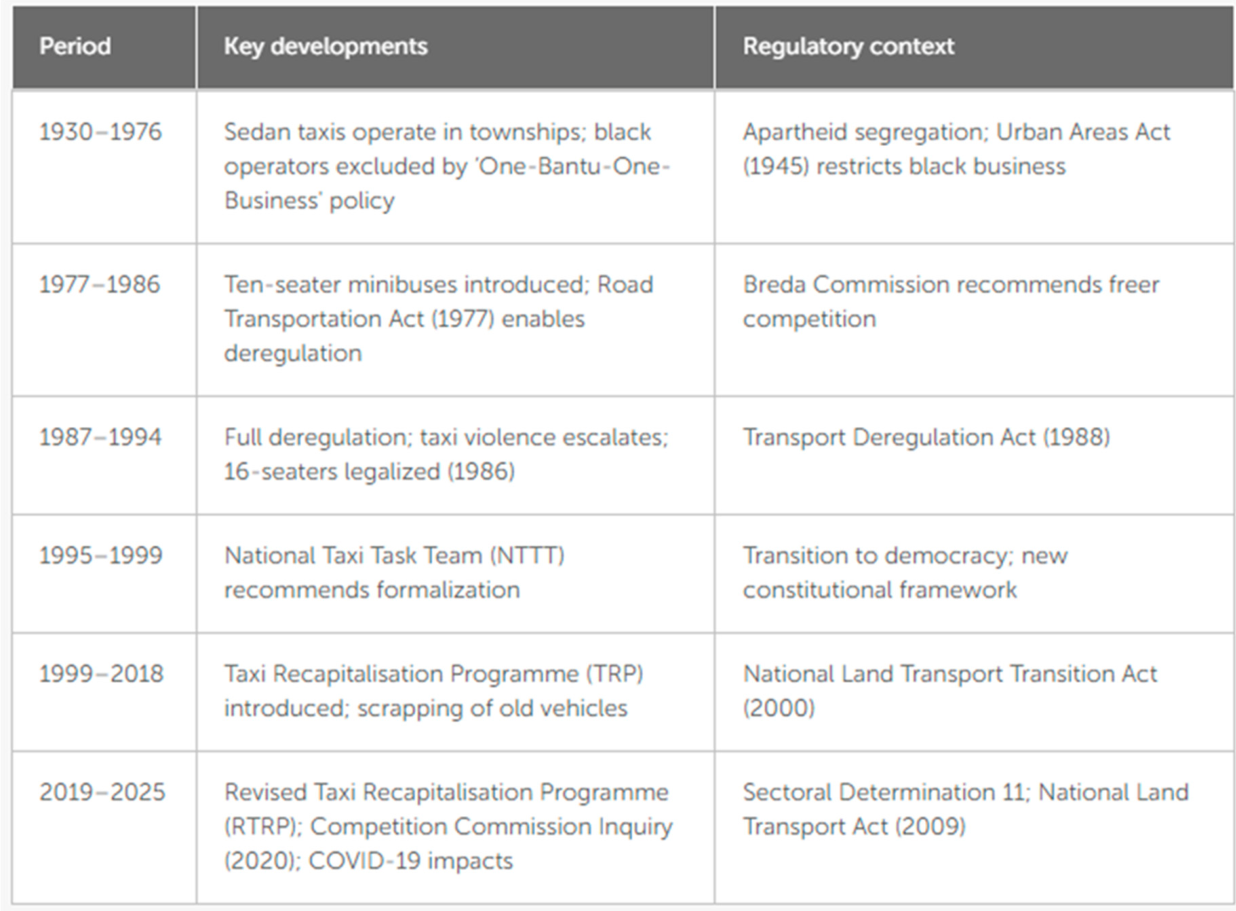
Figure 5.
Deaths and injuries caused by taxi violence, 1991–1999. Source: (Dugard, 2021)
Disclaimer/Publisher’s Note: The statements, opinions and data contained in all publications are solely those of the individual author(s) and contributor(s) and not of MDPI and/or the editor(s). MDPI and/or the editor(s) disclaim responsibility for any injury to people or property resulting from any ideas, methods, instructions or products referred to in the content. |
© 2026 by the authors. Licensee MDPI, Basel, Switzerland. This article is an open access article distributed under the terms and conditions of the Creative Commons Attribution (CC BY) license (http://creativecommons.org/licenses/by/4.0/).
Copyright: This open access article is published under a Creative Commons CC BY 4.0 license, which permit the free download, distribution, and reuse, provided that the author and preprint are cited in any reuse.