

Submitted:
24 August 2026
Posted:
25 August 2026
You are already at the latest version
Abstract
This article presents preliminary results from a geoarchaeological and geomorphological investigation of Amazigh agricultural landscapes in the western Anti Atlas (Morocco). Fieldwork followed two main survey transects across contrasting physiographic units, including external plateaus, synclinal depressions, the Kerdous inlier, and spring fed inner oases. The survey documented a wide range of landesque and associated agrarian features, including agricultural terraces, check dams, cisterns, threshing platforms, settlements, and fortified collective granaries (igoudar). Their distribution shows a strong relationship with geology, slope morphology, sediment availability, water circulation, and settlement organisation. On plateaus and synclines, agrarian structures are closely associated with igoudar, settlements, runoff control, and crop processing areas. Within the Kerdous inlier, extensive terracing occurs across rugged slopes, while inner oases combine spring fed agroforestry on valley floors with dense terracing along basin margins. These results suggest that the western Anti Atlas should be understood as a long term engineered socio ecological landscape shaped by Amazigh collective strategies for soil conservation, water management, cultivation, storage, and territorial protection.
Keywords:
landesque capital features
; geomorphology
; landscape archaeology
; land use
; Amazigh
; Anti-Atlas
; Morocco
1. Introduction
Archaeological and historical evidence shows that agricultural exploitation in arid and semi-arid North Africa did not follow a single trajectory [1,2,3,4]. Within Saharan and peri-Saharan settings, agriculture was especially dependent on places where water and soils could be concentrated, retained, or redistributed, such as floodplains, oases, springs, wadi beds, and slope systems. Research in North Africa has shown that rain-fed or flood-recession cultivation could occur in specific geomorphological niches even under hyper-arid conditions, suggesting a more flexible relationship between pastoralism and cultivation than previously assumed [5]. Yet, the history of agriculture in North Africa should not be understood only through a simple contrast between fertile river valleys and pastoral deserts, but also through the localized transformation of marginal environments into productive landscapes.
The agricultural role of mountain massifs separating coastal zones from Saharan lowlands remains comparatively less explored. These areas are often described as marginal environments primarily suited to pastoralism, yet in many parts of North West Africa mountain agriculture relied on forms of landesque capital, namely durable material investments designed to enhance land productivity beyond a single crop cycle [6]. In semi-arid mountain environments, such features do not only expand cultivable land; they also stabilize slopes, retain sediments, increase water infiltration, and reduce erosion, thereby linking agricultural production with geomorphological and hydrological regulation [7].
The Moroccan Anti-Atlas provides a particularly relevant context in which to examine these processes. Previous work has highlighted the importance of fortified collective granaries as key institutions of Amazigh rural society, as well as the widespread presence of terraced agroecosystems and slope-management practices in the western Anti-Atlas [8,9]. However, the spatial relationships between settlements and agricultural landesque capital remain insufficiently documented at the landscape scale. This is especially important because these features may not represent isolated rural remains, but rather the material components of an integrated socio-ecological system shaped by Amazigh communities through long-term adaptation to arid and semi-arid mountain conditions.
To address this gap, a joint project between Ibn Zohr University (Agadir, Morocco) and the Università degli Studi di Milano (Milan, Italy) has initiated a geoarchaeological and geomorphological investigation in the Moroccan Anti-Atlas. This Project Report presents the preliminary results, focusing on the identification, classification, and spatial distribution of landesque and associated agrarian features along a geological and topographic transect. Rather than providing a complete chronology, this preliminary study aims to define a working typology of the observed features and to assess how they are distributed across different physiographic units, from external plateaus and synclinal depressions to the Kerdous inlier (or Boutonnière) and its inner oasis systems.
2. Materials and Methods
2.1. Regional Backgrounds
2.1.1. Geographical and Geological Context
The study area is located in the Souss-Massa region of southern Morocco, within the province of Chtouka-Aït Baha. This province includes 22 rural communes, with Biougra as its administrative centre, and encompasses several historical tribal territories, including Idaougnidif in the southeast, Illalen in the west, Aït Abdellah in the north, Aït Toufaout in the east, and Aït Souab in the south (Figure 1).
The investigated sector extends into the mountain area locally known as the Adrar and includes the Jbel Lkest range, whose highest summit, Afa N’Timzgadiouine, rises above 2300 m a.s.l. The commune of Ida Ougnidif is characterized by a semi-arid steppe climate influenced by desert conditions. Mean annual temperature is approximately 15.2 °C, with January representing the coldest month and August the warmest [10]. Annual rainfall is low, averaging approximately 281 mm, and the Köppen-Geiger classification assigns the area to the BSk climatic zone [11] .
Geologically, the Anti-Atlas forms a major SW-NE-oriented mountain belt located along the northern edge of the West African Craton, between the Souss Basin and the High Atlas (Figure 1). The range extends for approximately 750 km in length and 250 km in width. It consists of Precambrian metamorphic, crystalline, and volcano-detrital formations overlain by a Cambrian sedimentary cover, mainly composed of carbonate units [12,13,14,15]. Classic geological studies of the Precambrian basement divide the Anti-Atlas into three main domains: the central Anti-Atlas, developed along both sides of the major Anti-Atlas fault; the western Anti-Atlas, located southwest of this fault; and the eastern Anti-Atlas, located northeast of it [16,17]. The western Anti-Atlas represents the frontal edge of the West African Craton and is composed of Lower Proterozoic rocks cratonized during the Eburnean orogeny. These are unconformably overlain by Upper Proterozoic calcareous-quartz sediments, which are in turn overlain by Late Proterozoic volcanic formations [18]. The survey sites are mainly located in the Kerdous massif, where Proterozoic and Paleozoic formations crop out extensively. From a geomorphological perspective, erosion has shaped an inlier-like relief, exposing Proterozoic terrains beneath the Paleozoic cover [19]. The Cambrian cover of the Kerdous massif includes Lower Cambrian reef limestones with Archaeocyathites, known as the Upper Limestones, which are locally quarried for marble and gravel. These Cambrian strata dip gently northward, with an inclination of approximately 25°. This structural setting reflects a long geological history involving synsedimentary and orogenic deformation during the Paleozoic, followed by Mesozoic-Cenozoic tectonic movements associated with the Atlantic margin and Atlas uplift [20]. The regional transect considered in this study crosses several geological and geomorphological units that are relevant for understanding the distribution of landesque and associated agrarian features. Before reaching the Aït Baha plateau, the route crosses the structural basin of Imi M’qourn, formed by fault-controlled subsidence affecting Lower Cambrian schists and terminal sandstones (Figure 1). The carbonate plateau of Aït Baha is characterized by a succession of Upper Limestones, the Wine-Lees Series, and Lower Limestones of the Lower Cambrian Adoudounian. Further east, the landscape reaches the Late Precambrian volcano-detrital terrains of the Ouarzazate Group, represented locally by the rhyolites of the Tanalt Group. Along the eastern flank of the Kerdous inlier, the stratigraphic transition from the terminal Proterozoic volcanic series of the Ouarzazate Group to the earliest Cambrian deposits can be observed. These deposits are capped by the Lower Tamjout limestones, which form a cuesta landscape. Near Tizourgane, the transect enters the Ida Ougnidif basin, developed on a basaltic substratum and bordered to the west by the quartzites of Jbel Lkest. These quartzites are overlain by thick conglomeratic deposits composed mainly of angular, poorly sorted quartzitic clasts within a siliceous matrix [20,21]. This geological and geomorphological variability provides the framework for the survey design. The selected transect crosses plateaus, structural basins, folded sectors, carbonate surfaces, volcanic and quartzitic terrains, and fault-controlled depressions. These settings offer different combinations of slope morphology, bedrock type, sediment availability, water circulation, and spring occurrence.
2.1.2. The Amazigh Culture on the Anti-Atlas
The Moroccan Anti-Atlas comprises a geographically and socially heterogeneous landscape. Environmental variability across the mountain range has supported contrasting patterns of settlement, mobility, and agricultural land use. In the central and eastern Anti-Atlas, where water resources are limited and cultivable land is scarce, pastoralism and forms of semi nomadism have historically played a dominant role [22]. By contrast, the western Anti-Atlas, located approximately between 29° and 30° N, benefits from relatively more favourable bioclimatic conditions associated with Atlantic moisture bearing air masses arriving from the west and northwest [23]. These conditions, together with the local availability of deeper soils, favoured the development of sedentary agriculture and a densely managed anthropogenic landscape.
The western Anti-Atlas is predominantly inhabited by Tachelhit speaking Amazigh communities [22]. Traditional social organisation is structured around nested territorial and kinship units, ranging from the tribe (taqbilt) to lineages (afous) and households (takat). This hierarchical organisation formed the basis of collective institutions responsible for the management of land, water, labour, and other shared resources. At the village level (jmaâ), composed of lineage representatives, administered communal affairs, arbitrated disputes, and enforced customary rules governing access to land, water, and grazing areas. These institutions played a fundamental role in the construction, maintenance, and regulation of the agrarian infrastructure that continues to characterise the region. Traditional land use in the western Anti-Atlas combined rain fed cereal cultivation, primarily barley, with arboriculture, including argan, almond, carob, olive, fig, and, locally, date palm. To overcome the scarcity of cultivable land and mitigate soil erosion, local communities progressively transformed hillslopes through the construction of agricultural terraces. Among the most distinctive institutions of Amazigh society in the Anti-Atlas are the fortified communal granaries (sing. agadir, pl. igoudar).
2.2. Geomorphological and Geoarchaeological Survey
The fieldwork consisted of a geomorphological and geoarchaeological survey organized along two main transects, one oriented approximately north-south and the other east-west (Figure 2). These transects were designed to cross different sectors of the Anti-Atlas fold-and-thrust belt and to document land-use features across contrasting physiographic contexts, including external plateaus, structural basins, folded sectors, steep escarpments, inner depressions, and spring-fed oasis systems (Figure 2). This approach allowed the survey to capture variability in slope morphology, lithostructural setting, sediment availability, water circulation, and settlement location. During the survey, visible evidence of landesque and associated agrarian features was mapped and georeferenced using QField software [24]. The field dataset was integrated into a GIS project developed during a previous desk-based phase of the research. The survey was not intended to provide an exhaustive inventory of all landesque features in the study area. Rather, it was designed as a regional diagnostic survey aimed at identifying recurrent feature types, documenting their geomorphological setting, and selecting representative locations for future detailed investigation. In this sense, the present contribution provides a preliminary typology and spatial assessment of the main agrarian and water-management features observed along the transects.
3. Results and Discussions
The survey identified a range of landesque agrarian features distributed across the investigated sector of the western Anti-Atlas. These include fortified collective granaries, settlements, agricultural terraces, lynchets, terraced fields, threshing platforms, cisterns, and check dams systems (Figure 3). Some features remain active or are occasionally reused, while others are abandoned but still clearly recognizable. In some cases, architectural elements have been restored and consolidated for use in geo-cultural tourism. The features are presented first according to their main morphology and function, and then across the principal physiographic units crossed by the survey: the external plateau, the eastern syncline, the Kerdous inlier and the inner oasis systems. This organization allows the spatial distribution of agrarian features to be discussed in relation to geology, topography, water availability, and settlement organization.
3.1. Typology of Landesque and Associated Features
The observed features can be grouped into four broad categories. The first category includes igoudar and rural settlements (Figure 3). Although igoudar are not landesque features in the strict sense, they are closely associated with agricultural production, storage, and protection. These fortified collective granaries were used to protect harvests, valuable goods, and documents belonging to community families. Their etymology refers to wall, enclosure, and fortified space, emphasizing their protective role [25].
Built in naturally defensible locations, including hilltops, rocky promontories, steep slopes, escarpment edges, and small tabular reliefs, igoudar display varied architectural forms, commonly rectangular, square, or oval [8,26] (Figure 4). Constructed in stone or rammed earth, they are generally enclosed by thick walls and accessed through a controlled entrance. Beyond their defensive and storage functions, they also acted as social and economic institutions, preserving barley, almonds, argan oil, and other goods during periods of drought, famine, or insecurity [26,27].
The second category includes agricultural terraces, lynchets, and terraced fields. Agricultural terraces are the most prominent features in the surveyed landscape. In Amazigh terminology, the retaining walls supporting these terraces are referred to as igherm, plural ighermane. Built in dry stone or, in irrigated sectors, with earthen mortar, these structures stabilized soils, retained runoff, and promoted the gradual accumulation of cultivable sediments [28]. The same semantic root may also refer, in different Amazigh-speaking contexts, to enclosure, protection, fortified settlement, or collective granary [25,26,29]. This overlap is important because it links terrace construction not only to cultivation, but also to protection and the securing of agricultural production.
Terrace development varies across the western Anti-Atlas, but some of the most extensive examples occur in the Kerdous inlier. Among the Aït Souab tribe (ibudraren, "the mountain people"), terraces occupy valley floors and hillslopes almost continuously, interrupted mainly by rocky outcrops and the steepest slopes (Figure 5). This dense terracing reflects a major collective investment in the stabilization, improvement, and valorization of cultivable land [30]. Most of the terraces recorded during the survey are relatively low, ranging from a few tens of centimetres to approximately one metre in height, and were built using locally available stones, mainly pebbles and small blocks. Many are abandoned or show signs of collapse, although some are still occasionally cultivated after significant rainfall. Along some slopes, stone retaining walls are no longer visible and the terrain is instead marked by lynchets, or earth banks. It remains uncertain whether these were originally constructed as earthen features or whether they represent former terraced sectors where dry-stone walls have entirely collapsed. Terraced fields are more limited in extent and occur especially in flatter areas or valley floors. They are often associated with agroforestry practices, including native argan trees combined with cereal cultivation [9].
The third category consists of threshing platforms, locally known as inraren (Figure 6). These are circular stone-paved platforms, generally 15 to 20 m in diameter, used for separating grain from chaff before storage. They occur on flat surfaces or in cantilevered positions along slopes, where they are supported downslope by dry-stone retaining walls. Their frequent proximity to igoudar, settlements, and terraced areas indicates a close spatial relationship between cultivation, crop processing, storage, and habitation.
The fourth category includes cisterns, check dams, springs, and water-channelling systems. Cisterns (tanodfi) are semi-subterranean masonry structures used to collect and store runoff water (Figure 7). They are generally built in stone, only rarely in mudbrick, internally plastered, and often arranged in vertically connected series linked by channels. Check dams were identified along impluvium lines, where they retained fertile soil, slowed surface runoff, and promoted water infiltration. Near oasis environments, springs occur especially at contacts between Precambrian bedrock and Cambrian sedimentary formations, and have been modified by water-channelling and redistribution systems. Taken together, these features form an integrated agrarian infrastructure. Terraces, threshing floors, cisterns, water-distribution systems, settlements, and igoudar should therefore be understood not as isolated elements, but as interdependent components of a socio-ecological landscape adapted to the constraints of the southern Moroccan mountains.
3.2. External Plateau
The external plateau is geologically characterized by the youngest rock units cropping out in the region, mainly pelites and limestones. These units are predominantly sedimentary and show horizontal to sub-horizontal bedding. The resulting structural configuration is marked by tabular reliefs with nearly flat bedding surfaces, locally showing slightly higher dips near the contact with the central sectors of the geological folds.
This geomorphological setting favoured the construction of stable settlements on the flat summits of tabular reliefs. In some cases, entire small mesas are occupied by settlements and igoudar, as illustrated by Agadir Imhilen and the settlement of Tizourgane. When located on plateau surfaces, settlements and igoudar are consistently placed close to escarpment edges. Below the upper vertical cliff, the moderately to gently sloping flanks of the tabular reliefs are systematically occupied by agricultural terraces and, more rarely, lynchets. These terraces occur at different elevations and show linear to braided patterns. In cases where settlements or igoudar occupy isolated conical hills within the plateau, the summit is used for habitation or storage, while terraces are arranged concentrically along the surrounding slopes.
The plateau provides one of the clearest examples of the close relationship between geology and agrarian construction. Terraces follow contour lines and often exploit steps created by horizontal rock layers of different resistance. This indicates a form of geological opportunism, in which terrace construction took advantage of pre-existing lithostructural features. According to local informants, some terraces are still occasionally cultivated after significant rainfall, showing that these features retain potential agrarian value despite partial abandonment.
Cisterns occur along the same slopes (Figure 7), especially in areas associated with settlements. Most are abandoned and often partially collapsed, but their presence attests to a planned system of water collection. The associated channel networks suggest that these cisterns were once interconnected and used to convey water downslope.
Threshing platforms are abundant across this sector. They are located near igoudar, settlements, and, in some cases, terraced slopes. The observed platforms show similar construction techniques: a paved base made of flat stone slabs, perimeter slabs set into the ground with a slight outward inclination, and compacted earth embankments surrounded by dry-stone walls. Where built in cantilevered positions along slopes, the retaining walls are thicker. Their distribution confirms that crop processing was spatially integrated with both storage facilities and cultivated slopes.
In areas with lower slope gradients, alignments of check dams occur along the main impluvia. These structures were designed to retain soil and moisture. Satellite imagery shows darker soils in these areas compared with surrounding interfluves, suggesting differences in soil thickness and moisture retention. The plateau therefore demonstrates how storage, settlement, terrace agriculture, threshing, runoff collection, and sediment retention were organized within the same geomorphological framework.
3.3. Eastern Syncline
The eastern syncline is a small north-south-oriented structure opening east of the plateau and representing its lateral continuation. The rocks forming the fold are strongly weathered, and erosion has shaped the structure into a depression with a flat floor surrounded by monoclinal slopes of variable inclination, often organized into flatiron systems. In the northern and western sectors, deeply incised bedrock canyons display meandering patterns and steep to sub-vertical walls.
Several landforms attributable to landesque techniques were identified in this sector. On the floors of the depressions, settlements are present, often associated with threshing areas. Some settlements remain inhabited, whereas others are abandoned and undergoing collapse. Agricultural terraces occur mainly along the marginal sectors of the depressions, while the central areas are more commonly characterized by flat, low-relief terraced fields. These fields are interspersed with, or associated with, check-dam systems located along impluvium lines (Figure 8).
Evidence of flood events was observed near some of these systems, where fine sediments have buried parts of the terraced fields. This indicates that the syncline floor was both agriculturally valuable and geomorphologically dynamic. The association between low-relief terraced fields and check dams suggests an attempt to combine cultivation with runoff control and sediment management in areas exposed to episodic flooding. The canyon sectors show a different pattern of occupation and land use. Traces of agadir remain recognizable, together with abandoned or partially active settlements. In some cases, settlements take the form of cliff-side structures developed along vertical canyon walls, where dry-stone walls exploit natural rock shelters to create enclosed spaces. Threshing areas are usually located closer to the valley floor, where flatter terrain is available. Agricultural terraces are instead built on less steep slopes and within lateral impluvia connecting non-continuous cliff segments.
The eastern syncline therefore illustrates how agrarian features adapted to a complex landscape of depression floors, monoclinal slopes, canyons, and impluvia. Settlement, cultivation, processing, and runoff-control structures were distributed according to local topography and geomorphological opportunities.
3.4. Interior of the Kerdous Massif
The inlier of Kerdous is a broad anticlinal fold in which the youngest sedimentary surface units have been eroded, exposing the Precambrian basement, mainly quartzites and volcanic rocks. The massif is strongly fractured and affected by fault systems. It reaches elevations of approximately 1950 m a.s.l. (min ~ 620, max ~ 1950, median ~ 1400 m a.s.l.) and is characterized by rugged morphologies, frequent near vertical slopes, and gentler areas that may be interpreted as structural surfaces. The contact between geological units of different permeability favours the occurrence of springs at different elevations.
Despite the complexity of the terrain, settlements are common. However, unlike the surrounding regions, igoudar are absent or extremely rare, and only settlements are present. This absence is notable given the importance of igoudar elsewhere in the western Anti-Atlas [8]. One possible explanation is that the naturally defensive character of the inlier, with its compartmentalized topography, deeply incised valleys, and difficult access routes, already provided protection. This interpretation remains hypothetical and requires further historical and archaeological investigation.
The most distinctive feature of this sector is the systematic modification of slopes through agricultural terraces. Terraces occur both near settlements and at higher elevations. Even rugged areas were equipped with soil-conservation structures, especially small linear or braided terraces located along minor impluvia where soils were more likely to accumulate. Only sectors dominated by exposed bedrock appear to have been left unmodified. Overall, settlements are mainly located on structural infill surfaces and in the few flatter areas, where threshing platforms are also concentrated, while terraces extend across virtually all usable slopes.
Many terrace systems in the inlier are now abandoned and recolonized by spontaneous vegetation. Nevertheless, they only rarely show clear evidence of structural collapse. This suggests that, even without active maintenance, some terrace systems retain morphological stability. Cisterns and other water-conservation systems are occasionally present, but they appear less prominent than in other sectors. The occurrence of springs, together with elevation and relative proximity to the Atlantic coast, may have supported cultivation along the slopes and reduced dependence on cistern-based water storage. The inlier therefore represents a landscape in which agricultural investment was concentrated primarily on slope stabilization and soil conservation rather than on fortified storage structures. Its extensive terracing demonstrates that cultivation was not limited to valley bottoms or easily accessible areas, but extended across rugged mountain slopes wherever sediment and moisture could be retained.
3.5. Inner Oases
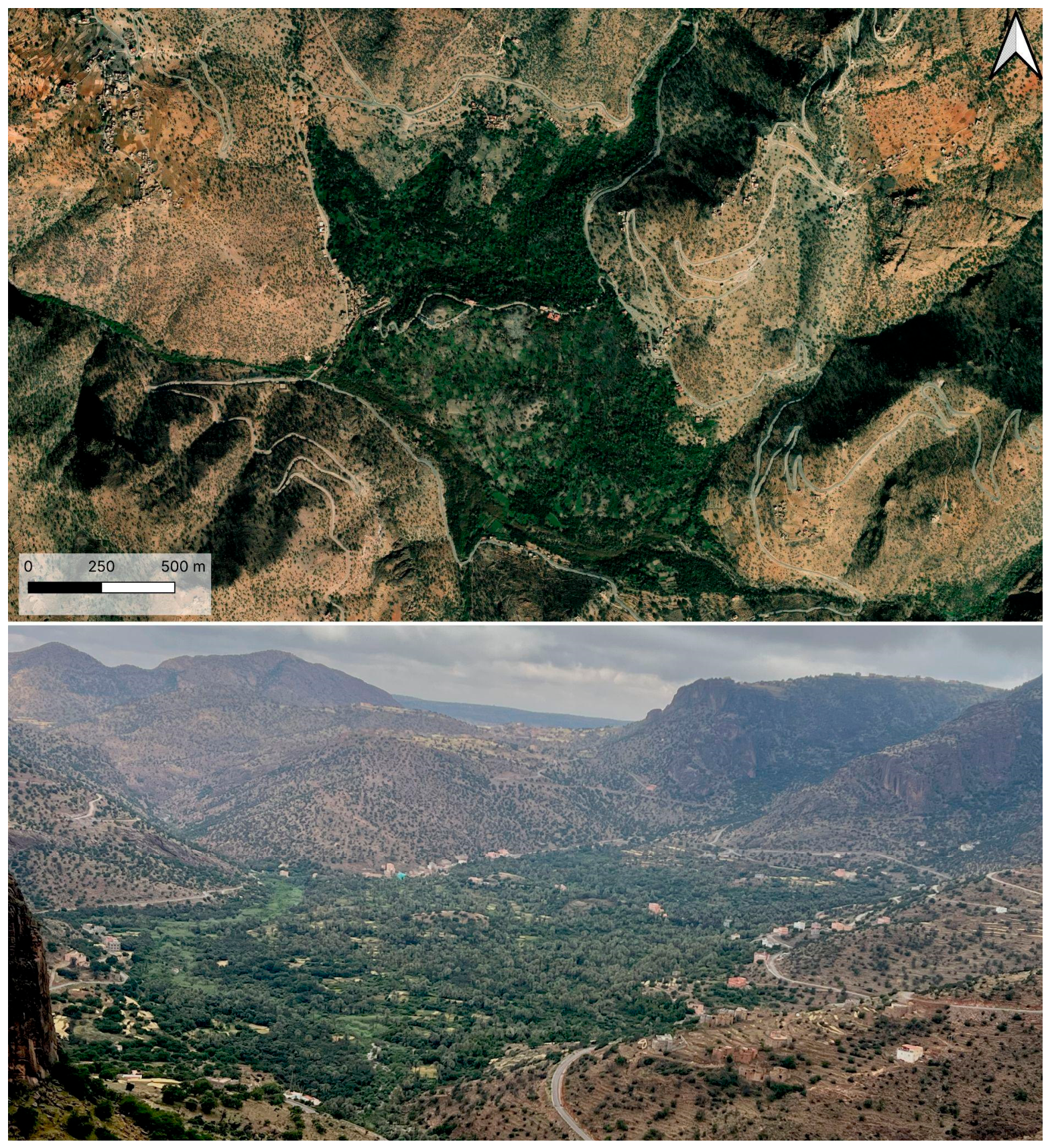
Within the Kerdous inlier, several depressions developed through the interaction of geological structure, especially faulting, weathering of the Precambrian bedrock, and fluvial erosion. In some of these depressions, spring-fed oases developed. Targa N’touchka provides one example (Figure 9). This oasis occupies a large fault-controlled depression characterized by coalescing alluvial fans fed by watercourses flowing from north to south. The fan surfaces and the surrounding slopes show extensive interventions aimed at improving agricultural production. The alluvial fans include both agricultural terraces and broader cultivable surfaces that can be interpreted as terraced fields. These areas support agroforestry systems combining cereal cultivation with fruit trees. Traditionally, date palms formed part of this system, while exotic species have also been introduced more recently. Water is supplied by six springs located along the margin of the depression and redistributed through artificial canals. The slopes surrounding the depression are relatively steep and densely covered by agricultural terraces. These terraces are generally closely spaced and extend to the upper margin of the basin. Terraces closer to the valley floor are generally better preserved and, in some cases, still in use. By contrast, terraces at higher elevations and on more exposed slopes appear to have been abandoned for a longer period and are now recolonized by natural vegetation. Recent rainfall produced lush vegetation across the study area, but satellite imagery still shows a clear contrast between the terraced slopes and the valley floor. The valley floor, continuously supplied by spring water, supports agroforestry on terraced fields, tree vegetation, and cultivated crops. The surrounding slopes depend more strongly on runoff management, soil retention, and terrace construction. The inner oases therefore combine two complementary agrarian systems: spring-fed agroforestry in the depression floor and slope terracing along the basin margins.
3.6. Cross-Transect Pattern
Across the investigated transect, the distribution of landesque and associated agrarian features shows a strong relationship with geology, landform structure, slope morphology, hydrology, and settlement location. On the external plateau, settlements and igoudar occupy elevated tabular surfaces and mesa edges, while terraces descend along escarpment slopes. Cisterns, threshing platforms, and check dams are spatially connected to these settlement and cultivation systems. In this sector, terrace construction frequently exploits horizontal bedding and natural rock steps.
In the eastern syncline, agrarian features are organized around depression floors, monoclinal slopes, canyon margins, and impluvium lines. Terraced fields and check dams dominate the flatter central areas, while settlements, threshing areas, terraces, and occasional fortified structures occupy canyon margins and protected topographic positions. The presence of flood deposits over some terraced fields suggests that cultivation in this sector was closely linked to sediment dynamics and episodic runoff.
In the inlier of Kerdous, the pattern changes markedly. Settlements are frequent, igoudar are absent or extremely rare, and terraces cover almost every usable slope. This suggests that local communities invested heavily in slope modification and soil retention, while the rugged morphology itself may have reduced the need for fortified collective granaries. In the inner oases, the availability of springs produced a different organization, with water-channelling systems, terraced fields, and agroforestry concentrated on alluvial fans and valley floors, while dense terraces extended across the surrounding slopes.
The overall pattern indicates that landesque features were not randomly distributed. They were placed according to opportunities and constraints created by geology, topography, sediment availability, water circulation, and social organization. Terraces, lynchets, check dams, cisterns, water channels, threshing floors, settlements, and igoudar together formed a mosaic of human landforms. Their distribution suggests long-term collective investment in the management of soil, water, agricultural production, storage, and protection. This integrated reading is reinforced by the repeated association between cultivation features and institutions of storage and protection. Igoudar protected harvests and valuable goods, while terraces protected soils and made cultivation possible. Threshing platforms connected production to processing, and cisterns, check dams, springs, and canals connected agricultural activity to runoff and water management. The semantic relationship between igherm (i.e. walls supporting agricultural terraces), enclosure, protection, fortified settlement, and collective granary further supports this interpretation [25,26,29]. The surveyed landscape therefore challenges a simplified view of the Anti-Atlas as a mountain area mainly suited to pastoralism. The evidence shows that agriculture extended from plateaus and synclines to rugged mountain slopes and spring-fed depressions. The western Anti-Atlas should therefore be understood as an engineered socio-ecological landscape, in which Amazigh communities developed durable infrastructures for managing soil, water, cultivation, processing, storage, and territorial protection.
At the same time, the present survey remains preliminary. It provides a typology and spatial interpretation of the observed features, but it does not yet establish the chronology of terrace construction, phases of abandonment, or long-term environmental effects. Future research should focus on representative locations across the external plateau, eastern syncline, inlier, and inner oases, with the aim of conducting detailed mapping, multiproxy analyses, and radiometric dating. Such work will be necessary to reconstruct the chronology of the various landesque systems and to assess their long-term effects on geomorphological processes, soil conservation, water management, and biodiversity.
4. Future Directions
The results presented here support the interpretation of the western Anti-Atlas as a long-term agrarian landscape shaped by the interaction between geological structure, topography, water availability, and Amazigh systems of collective land management. The documented terraces, cisterns, check dams, threshing floors, settlements, and igoudar should therefore be analysed as connected human landforms rather than as isolated archaeological or architectural features. Their distribution suggests that agricultural production was supported by durable strategies for slope stabilization, runoff control, soil retention, crop processing, and storage. Future research should move from regional survey to targeted investigation of selected sites across the main physiographic units identified in this study. Detailed architectural recording, high-resolution remote-sensing analysis, geoarchaeological sampling, and radiometric dating will be necessary to reconstruct the chronology of terrace construction, maintenance, abandonment, and reuse. This will also help clarify whether the contrast between the Kerdous margins and interior reflects differences in defence, settlement organization, agricultural practice, water availability, or broader cultural choices. A further priority is to assess the environmental effects of these landesque systems. Terraces, cisterns, check dams, and spring-fed fields may have influenced soil conservation, sediment storage, water infiltration, vegetation patterns, and biodiversity over long periods. Understanding these processes would allow the Anti-Atlas to be considered not only as a cultural heritage landscape, but also as a historical socio-ecological infrastructure with potential relevance for present debates on dryland resilience, landscape restoration, and sustainable mountain agriculture.
Author Contributions
Conceptualization, F.B.; methodology, F.B., A.E., M.Z. and A.Z. ; software, F.B..; validation, F.B., A.E., M.Z. and A.Z.; formal analysis, F.B., A.E., M.Z. and A.Z.; investigation, F.B., A.E., M.Z. and A.Z.; resources, F.B. and A.Z.; data curation, F.B.; writing—original draft preparation, F.B., A.E., M.M.S., M.Z. and A.Z.; writing—review and editing, F.B., A.E., M.M.S, M.Z. and A.Z.; visualization, F.B., M.M.S and A.Z.; supervision, F.B.; project administration, F.B.; funding acquisition, F.B. All authors have read and agreed to the published version of the manuscript.
Funding
This research is funded by the Università degli Studi di Milano through the Piano di Sostegno per la Ricerca 2025 - Linea 4 and Linea 8. This work forms part of the activities conducted within the framework of the Dipartimento di Eccellenza 2023-2027 (WP2), a designation awarded by the Italian Ministry of University and Research (MUR) to the Dipartimento di Scienze della Terra “Ardito Desio” at the Università degli Studi di Milano.
Conflicts of Interest
The authors declare no conflicts of interest.
References
- Wengrow, D.; Dee, M.; Foster, S.; Stevenson, A.; Ramsey, C.B. Cultural Convergence in the Neolithic of the Nile Valley: A Prehistoric Perspective on Egypt’s Place in Africa. Antiquity 2014, 88, 95–111. [Google Scholar] [CrossRef]
- Garcea, E.A.A. Multi-Stage Dispersal of Southwest Asian Domestic Livestock and the Path of Pastoralism in the Middle Nile Valley. Quat. Int. 2016, 412, 54–64. [Google Scholar] [CrossRef]
- Dunne, J.; di Lernia, S.; Chłodnicki, M.; Kherbouche, F.; Evershed, R.P. Timing and Pace of Dairying Inception and Animal Husbandry Practices across Holocene North Africa. Quat. Int. 2018, 471, 147–159. [Google Scholar] [CrossRef]
- Morales, J.; Pérez-Jordà, G.; Peña-Chocarro, L.; Zapata, L.; Ruíz-Alonso, M.; López-Sáez, J.A.; Linstädter, J. The Origins of Agriculture in North-West Africa: Macro-Botanical Remains from Epipalaeolithic and Early Neolithic Levels of Ifri Oudadane (Morocco). J. Archaeol. Sci. 2013, 40, 2659–2669. [Google Scholar] [CrossRef]
- di Lernia, S.; N’Siala, I.M.; Mercuri, A.M.; Zerboni, A. Land-Use and Cultivation in the Etaghas of the Tadrart Acacus (south-West Libya): The Dawn of Saharan Agriculture? Antiquity 2020, 94, 580–600. [Google Scholar] [CrossRef]
- Hakansson, N.T.; Widgren, M. (Eds.) Landesque Capital. In New Frontiers in Historical Ecology; Routledge: London, England, 2016; ISBN 9781315425672. [Google Scholar]
- Boselli, V.; Ouallali, A.; Briak, H.; Houssni, M.; Kassout, J.; El Ouahrani, A.; Michailidi, E.M. System Dynamics Applied to Terraced Agroecosystems: The Case Study of Assaragh (Anti-Atlas Mountains, Morocco). Water 2020, 12, 1693. [Google Scholar] [CrossRef]
- Popp, H.; Hamza, M.A.; El Fasskaoui, B. Les agadirs de l’Anti-Atlas occidental atlas illustré d'un patrimoine culturel du Sud marocain; Naturwissenschaftliche Gesellschaft Bayreuth: Bayreuth, Germany, 2011; ISBN 9783939146070. [Google Scholar]
- Ziyadi, M.; Dahbi, A.; Aitlhaj, A.; El Ouahrani, A.; El Ouahidi, A.; Achtak, H. Terraced Agroforestry Systems in West Anti-Atlas (Morocco): Incidence of Climate Change and Prospects for Sustainable Development. In Climate Change-Resilient Agriculture and Agroforestry: Ecosystem Services and Sustainability; Castro, P., Azul, A.M., Leal Filho, W., Azeiteiro, U.M., Eds.; Springer International Publishing: Cham, 2019; pp. 1–19. ISBN 9783319750040. [Google Scholar]
- Conseil Supérieur de l’Eau et du Climat The Economic Management of the Water and Recommendations; Conseil Supérieur de l’Eau et du Climat: Agadir, 2011.
- Beck, H.E.; Zimmermann, N.E.; McVicar, T.R.; Vergopolan, N.; Berg, A.; Wood, E.F. Present and Future Köppen-Geiger Climate Classification Maps at 1-Km Resolution. Sci. Data 2018, 5, 180214. [Google Scholar] [CrossRef] [PubMed]
- Boudda, A.; Choubert, G. Sur La Limite Inférieure Du Cambrien Au Maroc. Comptes Rendus De l’Académie Des. Sci. De Paris 1972, 275, 5–8. [Google Scholar]
- Debrenne, F. Archaeocyatha Du Maroc: Essai de Synthèse. Géologie Méditerranéenne 1990, 17, 213–227. [Google Scholar] [CrossRef]
- Schmitt, M. Stromatolites from the Tiout Section, Precambrian--Cambrian Boundary Beds, Anti-Atlas, Morocco. Geol. Mag. 1978, 115, 95–100. [Google Scholar] [CrossRef]
- Sdzuy, K. The Precambrian--Cambrian Boundary Beds in Morocco: Preliminary Report. Geol. Mag. 1978, 115, 83–94. [Google Scholar] [CrossRef]
- Choubert, G. L’accident Majeur de l'Anti-Atlas. Comptes Rendus De l’Académie Des. Sci. De Paris 1947, 224, 1172–1173. [Google Scholar]
- Choubert, G.; Faure-Muret, A. Les Corrélations Du Précambrien, Anti-Atlas Occidental et Central. In Proceedings of the Colloque international sur les corrélations du Précambrien, Agadir--Rabat; Agadir--Rabat, 1970; pp. 3–23. [Google Scholar]
- Leblanc, M.; Lancelot, J.R. Interprétation Géodynamique Du Domaine Pan-Africain (Précambrien Terminal) de l’Anti-Atlas (Maroc) à Partir de Données Géologiques et Géochronologiques. Can. J. Earth Sci. 1980, 17, 142–155. [Google Scholar] [CrossRef]
- Sebbab, M.M. La Géomatique Au Service de La Gestion Des Carrières: L’optimisation de L'implantation Des Carrières Entre Les Potentialités Géologiques et Les Contraintes Géomorphologiques et Environnementales. In Le Cas de La Boutonnière d'Ifni et Le Plateau de Lakhssas, Maroc; Université Ibn Zohr, 2024. [Google Scholar]
- Soulaimani, A.; Ouanaimi, H. Anti-Atlas et Haut Atlas, Circuit Occidental. Nouv. Guid. Géologiques Et. Min. Du. Maroc. 2011, 3, 9–72. [Google Scholar]
- Geyer, G.; Landing, E. A Unified Lower--Middle Cambrian Chronostratigraphy for West Gondwana. Acta Geol. Pol. 2004, 54, 179–218. [Google Scholar]
- Maddy-Weitzman, B. The Berbers (Amazigh). In Routledge Handbook of Minorities in the Middle East; Routledge: Milton Park, Abingdon, Oxon; New York, NY; Routledge, 2019., 2018; pp. 313–325. ISBN 9781315626031. [Google Scholar]
- Oliva, P. Aspects et Problèmes Géomorphologiques de l’Anti-Atlas Occidental. Rev. De Géographie Du. Maroc. 1972, 21, 43–76. [Google Scholar]
- OPENGIS.ch. QField: Efficient Fieldwork Built for QGIS; OPENGIS.ch: Lausanne, Switzerland, 2026. [Google Scholar]
- Laoust, É. Mots et Choses Berbères. Notes de Linguistique et D’ethnographie: Dialectes Du Maroc; Augustin Challamel Éditeur: Paris, 1920. [Google Scholar]
- Meunié, J. Les Greniers Collectifs Au Maroc. J. De La Société Des. Afr. 1944, 14, 1–16. [Google Scholar] [CrossRef]
- Zarguef, A. Un Espace Montagnard et Une Société En Crise Au Cœur de l’Anti-Atlas: La Contrée d'Igherm, Université Nancy 2; 2001. [Google Scholar]
- Sabir, M. The Terraces of the Anti-Atlas: From Abandonment to the Risk of Degradation of a Landscape Heritage. Water 2021, 13, 510. [Google Scholar] [CrossRef]
- Ait Hamza, M. Environnement et Stratégies Paysannes Dans Le Haut-Atlas Central. In La montagne marocaine, dynamiques agraires et développement durable; Laouina, A., Ed.; Université Mohamed V, Publications de la chaire UNESCO-GAZ NATURAL ``Gestion de l’environnement et développement durable'': Rabat, 2000; pp. 35–61. [Google Scholar]
- Ziyadi, M. Vie Rurale et Aménagement Des Pentes Dans l’Anti-Atlas Occidental, Maroc. In Espaces, Archéologie, Patrimoines; PUN; Éditions Universitaires de Lorraine: Nancy, 2013. [Google Scholar]
Figure 1.
Geological setting of the Kerdous inlier in the western Anti-Atlas, southern Morocco. (A) Regional inset showing the position of the mapped area within the Anti-Atlas belt along the northern margin of the West African Craton. (B) Simplified geological map of the western Anti-Atlas between Ifni, Tiznit, Taroudant and Akka, highlighting the distribution of Proterozoic basement inliers, the Adoudounian and Ouarzazate Group successions, Paleozoic sedimentary units, post-Paleozoic cover, and Triassic–Liassic dykes and sills. The main inliers and localities, including Ifni, Kerdous, Tafraout, Tagragra d’Akka and Igherm, are indicated.
Figure 1.
Geological setting of the Kerdous inlier in the western Anti-Atlas, southern Morocco. (A) Regional inset showing the position of the mapped area within the Anti-Atlas belt along the northern margin of the West African Craton. (B) Simplified geological map of the western Anti-Atlas between Ifni, Tiznit, Taroudant and Akka, highlighting the distribution of Proterozoic basement inliers, the Adoudounian and Ouarzazate Group successions, Paleozoic sedimentary units, post-Paleozoic cover, and Triassic–Liassic dykes and sills. The main inliers and localities, including Ifni, Kerdous, Tafraout, Tagragra d’Akka and Igherm, are indicated.
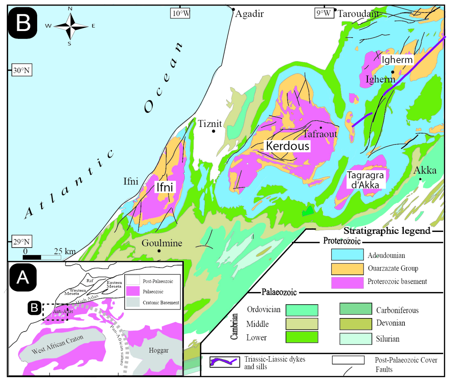
Figure 2.
Physiographic setting of the Kerdous Massif survey area. Digital elevation model showing the main survey sectors, including the interior massif, inner oasis, external plateau and external syncline; inset shows the project location in Morocco.
Figure 2.
Physiographic setting of the Kerdous Massif survey area. Digital elevation model showing the main survey sectors, including the interior massif, inner oasis, external plateau and external syncline; inset shows the project location in Morocco.
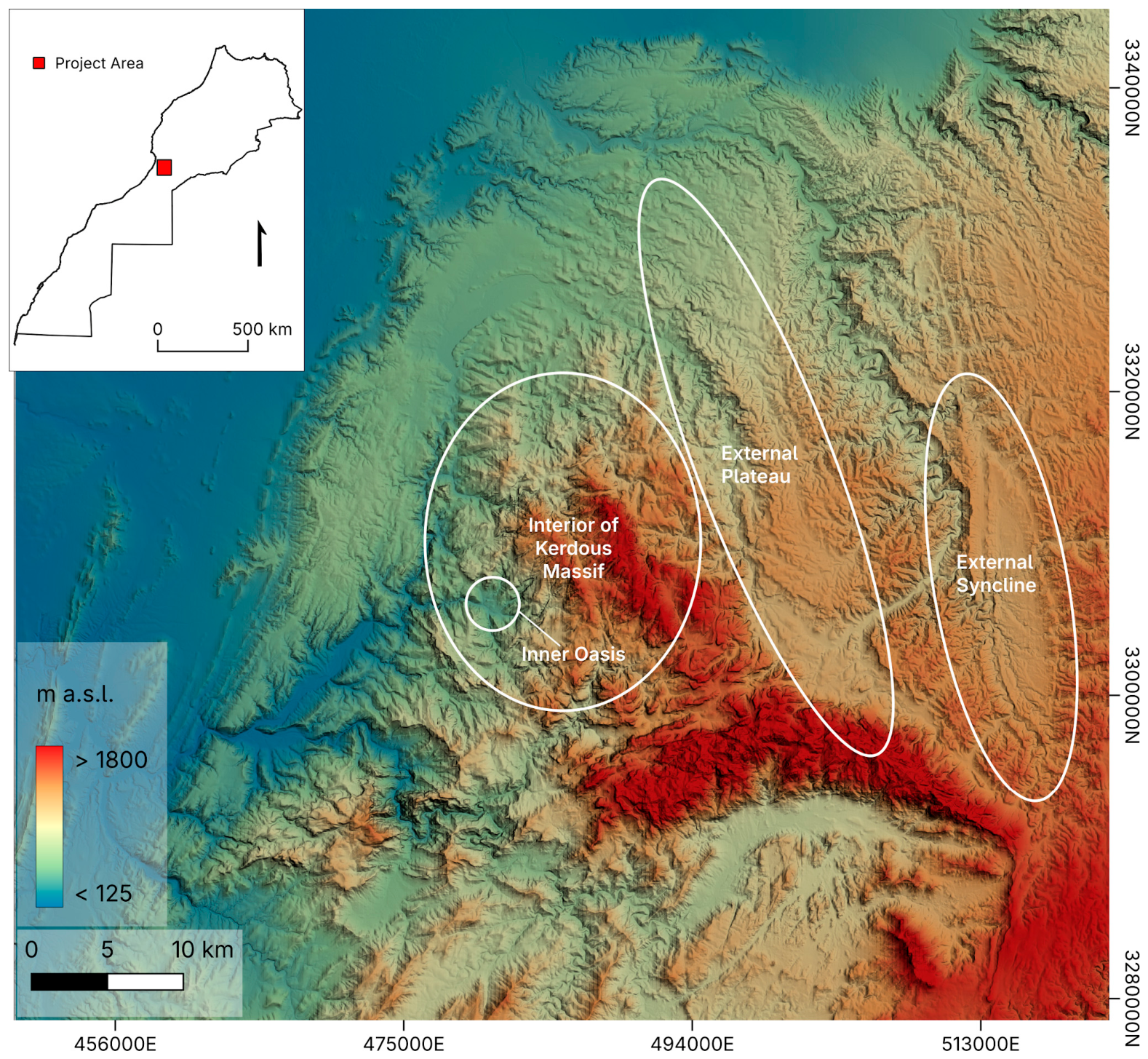
Figure 3.
Oblique aerial view of Agadir n’Tazrout: (1) agadir, (2) threshing areas, (3) settlement, and (4) agricultural terraces.
Figure 3.
Oblique aerial view of Agadir n’Tazrout: (1) agadir, (2) threshing areas, (3) settlement, and (4) agricultural terraces.
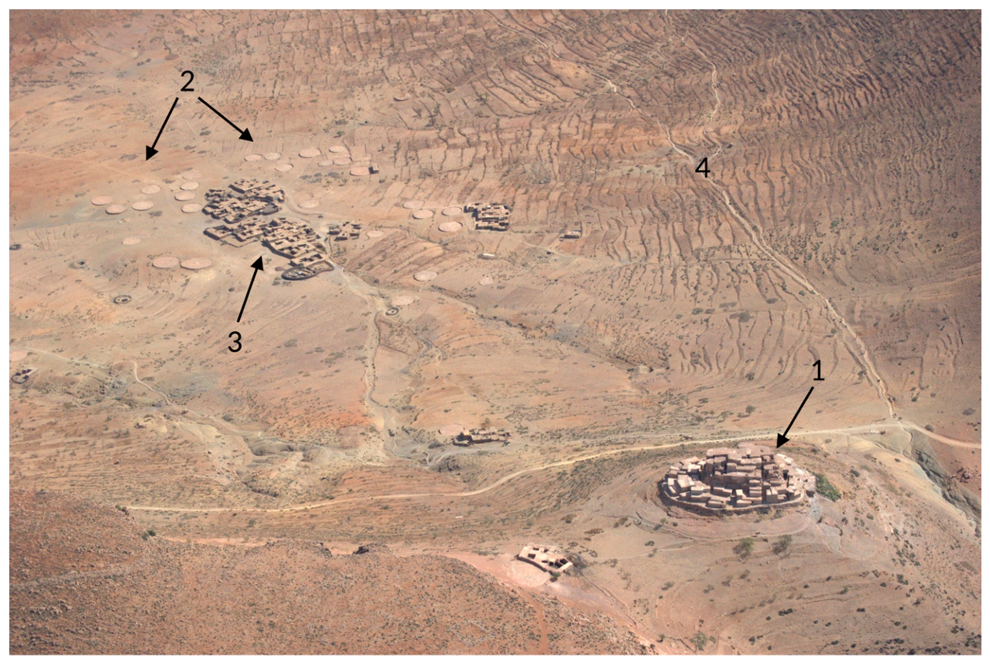
Figure 4.
Examples of igoudar shapes and the interior of Agadir Ighir Ifran.
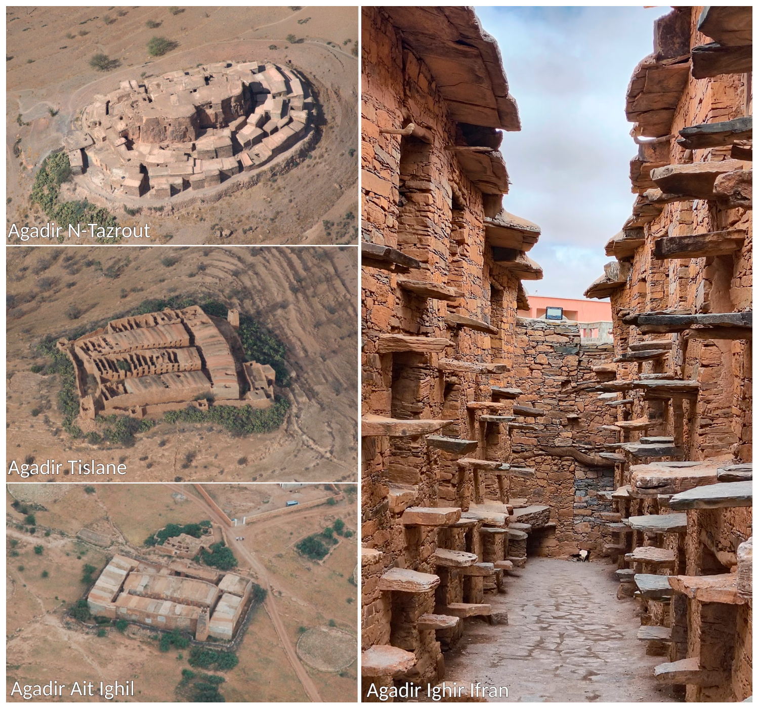
Figure 5.
Agricultural terrace systems surrounding the abandoned village of Ifghel Ibnanaten.
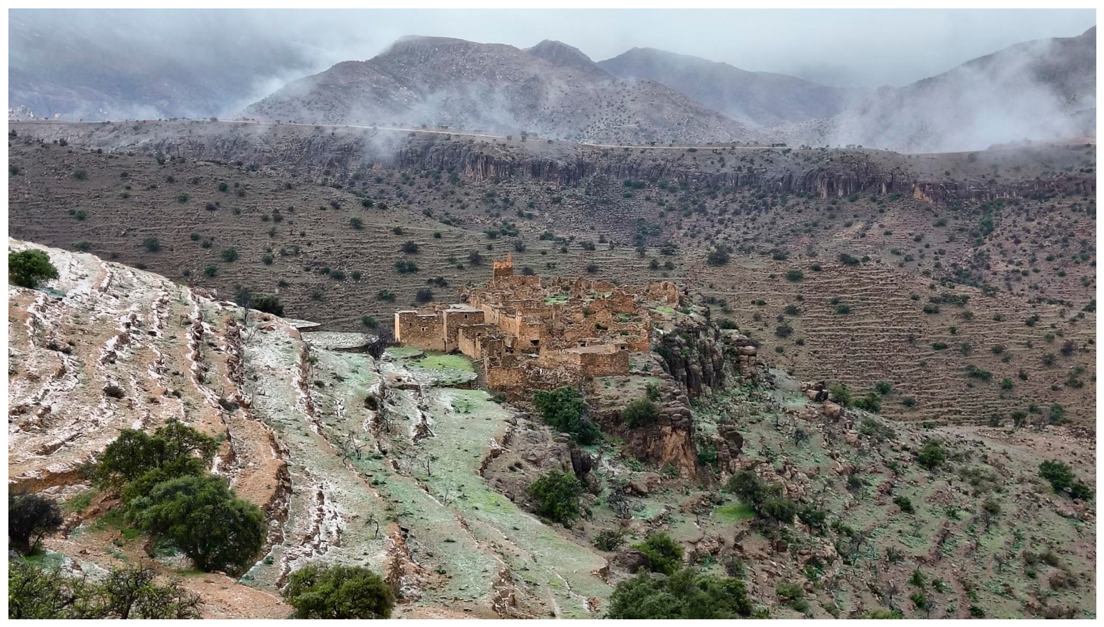
Figure 6.
Examples of threshing platforms, locally known as inraren.
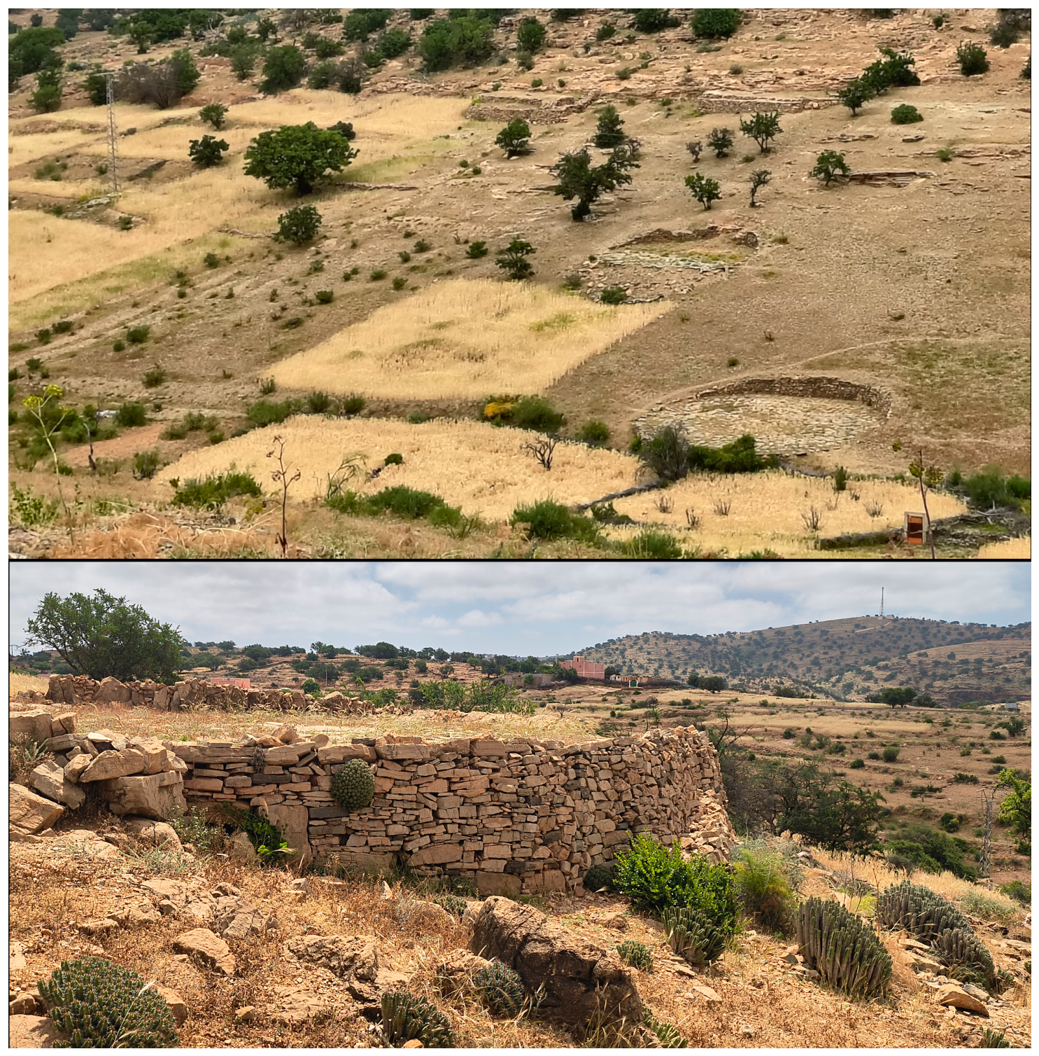
Figure 7.
Examples of interconnected cisterns along the slope (top) and detail of an individual cistern (bottom).
Figure 7.
Examples of interconnected cisterns along the slope (top) and detail of an individual cistern (bottom).
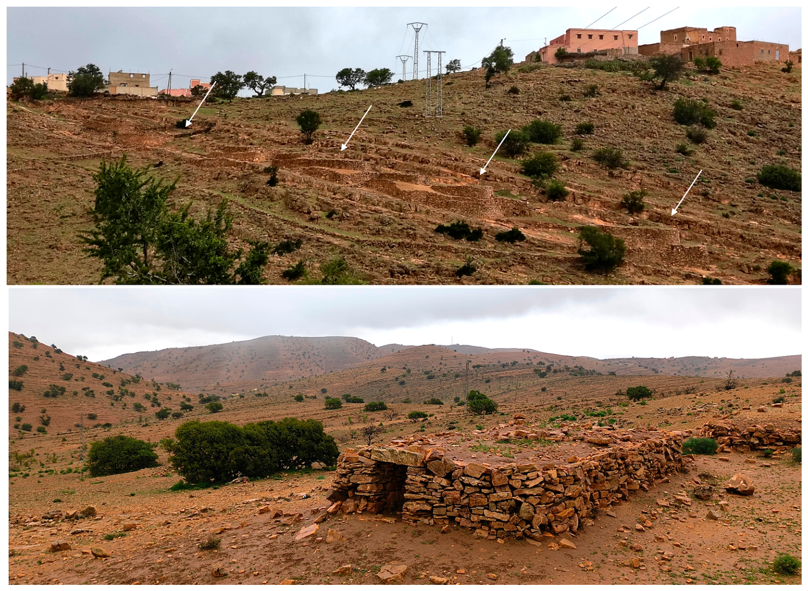
Figure 8.
Example of check-dam systems near the village of Fouanou.
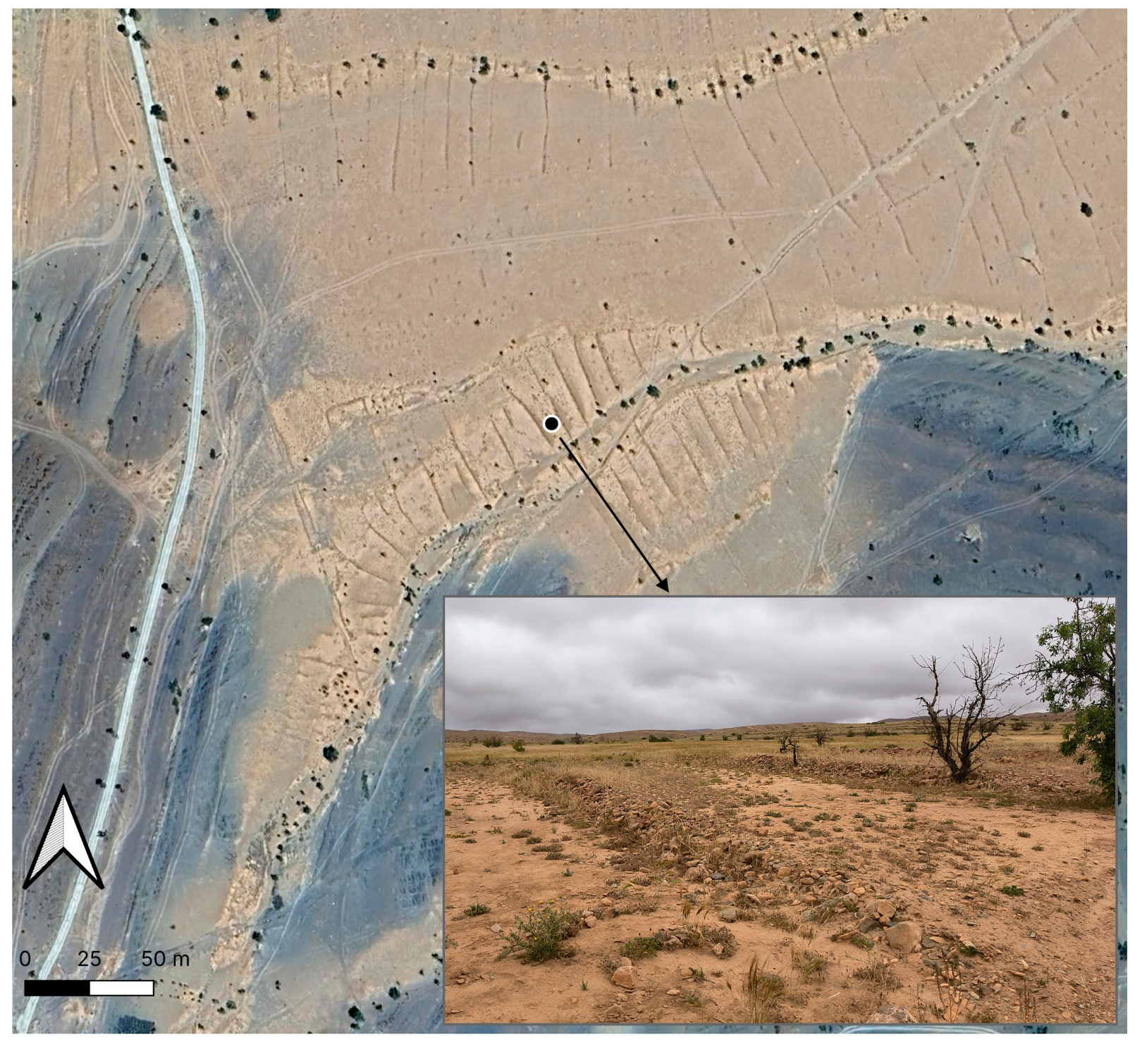
Figure 9.
Targa N’touchka oasis.
Disclaimer/Publisher’s Note: The statements, opinions and data contained in all publications are solely those of the individual author(s) and contributor(s) and not of MDPI and/or the editor(s). MDPI and/or the editor(s) disclaim responsibility for any injury to people or property resulting from any ideas, methods, instructions or products referred to in the content. |
© 2026 by the authors. Licensee MDPI, Basel, Switzerland. This article is an open access article distributed under the terms and conditions of the Creative Commons Attribution (CC BY) license (http://creativecommons.org/licenses/by/4.0/).
Copyright: This open access article is published under a Creative Commons CC BY 4.0 license, which permit the free download, distribution, and reuse, provided that the author and preprint are cited in any reuse.