

Submitted:
20 August 2026
Posted:
20 August 2026
You are already at the latest version
Abstract
Road traffic crashes remain a major public safety concern in Ecuador, particularly on the General Rumiñahui Highway, a high-demand corridor characterized by complex geometry, variable traffic density, and operational constraints. This study proposes a three-layer hybrid framework to support real-time accident risk prediction and prevention in this corridor. The architecture integrates Internet of Vehicles (IoV) data acquisition through roadside and vehicular sensors, IP cameras, and environmental sensors; Multi-access Edge Computing (MEC) for local processing, YOLOv8-based visual perception, and V2V, V2I, and V2P communications; and cloud-based predictive analytics using a CNN–LSTM model. The framework is aligned with ISO 37106:2021 and ISO 37122:2019 to promote interoperability, smart-city operational integration, and mobility-related performance indicators. Its ex ante validation relies on comparative evidence from studies of equivalent architectures and on the consistency of available institutional data sources. Reported evidence supports the technical plausibility of visual detection, spatiotemporal risk modeling, and low-latency MEC-enabled V2X communications; however, these results do not constitute empirical performance measurements for the General Rumiñahui Highway. The study concludes that the proposed framework is a technically feasible basis for a future instrumented pilot, subject to institutional integration, sufficient sensing infrastructure, connectivity, and field validation.
Keywords:
internet of vehicles
; multi-access edge computing
; V2X communication
; computer vision
; YOLOv8
; deep learning
; CNN-LSTM
; traffic accident prediction
; road safety
; smart city
1. Introduction
Road safety remains a persistent challenge for public health, urban development, and mobility management. Globally, road traffic crashes continue to cause more than one million deaths each year and disproportionately affect vulnerable road users, including pedestrians, cyclists, and motorcyclists [12]. The situation is also critical in Ecuador: 4,789 road traffic crashes, 4,032 injuries, and 603 deaths were reported during the first quarter of 2026, while 8,718 crashes and 1,022 deaths were reported between January and May of the same year [13,15]. These figures underline the need to complement conventional enforcement, traffic control, and emergency-response measures with mechanisms able to identify risk conditions before a crash occurs.
The issue is particularly relevant in high-demand corridors with complex roadway geometry. The General Rumiñahui Highway links Quito with the eastern valleys along an approximately 10-km segment characterized by steep slopes, sharp curves, variable weather conditions, and heterogeneous traffic flows. In such settings, operating speed, peak-hour congestion, and limited reaction windows can increase the likelihood and severity of traffic events. Accordingly, Sustainable Development Goal 3.6 calls for halving road traffic deaths and injuries by 2030, reinforcing the importance of preventive, interoperable, and locally adapted interventions [16].
The Internet of Vehicles (IoV) extends Internet-of-Things capabilities to the mobility ecosystem through information exchange among vehicles, infrastructure, road users, and digital services. Vehicle-to-vehicle, vehicle-to-infrastructure, and vehicle-to-everything (V2V, V2I, and V2X) communications enable the integration of position, speed, trajectory, environmental, and visual-perception data to support real-time safety decisions [1,2]. In parallel, computer-vision systems based on object-detection models such as YOLOv8 can support traffic-flow monitoring, anomalous-behavior identification, and incident detection using roadside video streams [4,5]. Deep-learning models that combine spatial and temporal components, including CNN–LSTM and GNN–LSTM architectures, have also shown advantages over conventional classifiers for modeling complex road-risk patterns [22,31].
Nevertheless, the literature does not provide a single, constraint-free solution. A relevant design trade-off exists between centralized cloud processing, which supports model training and large-scale historical data integration, and Multi-access Edge Computing (MEC), which reduces communication paths and is better suited to latency-sensitive V2X services [7,8,48]. Likewise, the performance of vision-based systems depends on video quality, illumination, occlusions, camera placement, and operational diversity; consequently, performance metrics reported in other corridors cannot be assumed to transfer directly to the General Rumiñahui Highway [5,10]. IoV deployments also face interoperability, privacy, security, scalability, and data-trust challenges that must be addressed before operational adoption [2,11].
Although substantial advances have been reported in IoV, visual perception, predictive analytics, and MEC, few studies combine these components into a unified architecture for high-speed mountainous corridors. In particular, no direct empirical evidence was identified for IoV–MEC deployments on the General Rumiñahui Highway. This gap is especially relevant in Ecuador, where implementation must account for heterogeneous data sources, connectivity constraints, and coordination among road-traffic, public-safety, and roadway-management institutions.
This work therefore proposes a three-layer hybrid framework to support real-time crash-risk prediction and prevention on the General Rumiñahui Highway. The first layer integrates IoV sensors, IP cameras, and environmental sensors; the second applies MEC-enabled local processing, YOLOv8-based visual perception, and V2V, V2I, and V2P communications; and the third uses cloud-based predictive analytics through a CNN–LSTM model. The framework is aligned with ISO 37106:2021 for smart-city operating models and ISO 37122:2019 mobility indicators [52,53]. The reviewed comparative evidence supports the technical plausibility of the proposed components; however, the principal conclusion remains ex ante: the framework provides a technically viable basis for an instrumented pilot, while its actual effectiveness must be established through institutional integration, adequate sensing and connectivity, and empirical field validation.
2. Literature Review
Road safety on high-demand highways remains a critical problem within modern transportation systems. Several studies agree that the combination of vehicular growth, dynamic environmental conditions, and human factors increases the probability of accidents and complicates real-time decision-making [17,18,19]. Within the reviewed collection, no document was found that specifically addresses the General Rumiñahui Highway or the Quito–Valles corridor; therefore, the analysis that follows is based on the broader literature on IoV, computer vision, machine learning, and accident prevention, rather than on direct evidence about this particular road.
2.1. Internet of Vehicles (IoV)
The Internet of Vehicles (IoV) has evolved into a key architecture within intelligent transportation systems, enabling the interconnection of vehicles, users, infrastructure, and services through V2V, V2I, and V2X communication [20,21,23]. The literature highlights that IoV can improve road safety, traffic efficiency, and operational coordination through continuous real-time information exchange [22,24]. However, serious limitations are also acknowledged, related to quality of service, channel interference, high mobility, data privacy, and system scalability [25,26,27].
2.2. Environmental Perception and Computer Vision
Environmental perception through sensors and computer vision constitutes another central axis of the state of the art. The reviewed documents show that connected systems typically integrate cameras, radar, LiDAR, GPS, ultrasound, and other modalities to obtain a more complete representation of the environment [20,28,29]. In particular, sensor fusion is presented as an effective strategy to compensate for the limitations of each individual modality, especially when detection under complex conditions requires greater tolerance to uncertainty [20,29]. In the field of computer vision, several works report the use of object detection models for vehicle monitoring, traffic counting, anomaly identification, and event classification [30,31,32]. A clear example is the approach that uses YOLOv8 combined with temporal filters to improve vehicle-counting stability and detect small objects in complex urban environments [30]. Even so, the literature also warns that dependence on video quality, camera angle, and visibility conditions can affect system performance [31]. This type of finding suggests that computer vision alone is not sufficient to build a reliable accident-prevention solution.
2.3. Driver and Vehicle State Detection
Driver and vehicle state detection also occupies a relevant place in the literature. Some studies propose visual or multimodal monitoring to identify drowsiness, distraction, physical deterioration, or anomalous behavior [28,33]. In particular, the use of remote photoplethysmography (rPPG) to estimate vital signs and assess driver condition emerges as a promising line of research, although the technique is recognized as sensitive to motion artifacts and lighting changes [33]. On the other hand, studies on cooperative driver-assistance systems emphasize that the interaction among driver, vehicle, and environment must be analyzed holistically rather than in isolation [37]. This supports the idea of a systemic design, in which visual perception, vehicular communication, and control logic are integrated within a single architecture.
2.4. Machine Learning and Deep Learning
In the field of machine learning and deep learning, the literature shows a wide variety of methodologies. Classical models such as decision trees, SVM, KNN, Naive Bayes, and regression continue to be used for classification, prediction, and risk-assessment tasks [19,34,35]. However, several works show that more recent deep-network-based approaches offer better capacity to model complex traffic and accident patterns [22,31,33]. In particular, the combination of convolutional neural networks, LSTM, GNN, and attention mechanisms has been used to capture the spatial and temporal dependencies associated with accident risk and traffic anomalies [22,31]. Furthermore, the literature recognizes class imbalance as an important limitation, since severe accidents tend to be rare events; accordingly, techniques such as ADASYN and focal loss have been employed to improve learning in scenarios where the minority class is critical [22].
2.5. Hybrid Architectures, MEC, and Distributed Computing
An important trend toward hybrid frameworks that combine computer vision, machine learning, and distributed or edge computing can be observed. A 2026 study develops a spatiotemporal monitoring architecture that combines optimized YOLOv8 with virtual induction loops, improving vehicle-counting stability in complex urban environments [30]. In parallel, the literature on Multi-access Edge Computing (MEC) applied to V2X consistently demonstrates that edge processing substantially reduces end-to-end latency: a seminal study reports emergency message delivery in under 100 ms via MEC, compared to significantly higher latencies in conventional LTE scenarios [48], while a 2025 study on the integration of MEC with fully decoupled radio access networks (FD-RAN) confirms additional reductions in end-to-end latency for C-V2X communications under high traffic loads [49]. A June 2026 study on supporting critical V2X services through 5G V2N2V (Vehicle-to-Network-to-Vehicle) communications demonstrates that these services can be reliably supported only over MEC-based network deployments, requiring local interconnection points or MEC federation to overcome asymmetries between different operators’ network deployments [46]. The ETSI ISG MEC specification group has formalized specific recommendations for supporting V2X use cases through MEC infrastructure, including local, real-time information aggregation with very low latency [50].
2.6. Identified Gaps
Even so, the review reveals several gaps. First, few works propose a complete framework combining IoV, computer vision, machine learning, MEC, and accident prevention in the context of a high-speed mountain highway [17,18]. Second, the literature shows that data are often incomplete, heterogeneous, or imbalanced, which affects model generalization [19,22]. Third, IoV security is not limited to the detection problem; trust management and consensus mechanisms are essential to guarantee the integrity of information shared between vehicles and infrastructure [21,24]. Fourth, the literature on MEC-V2X has been developed predominantly on reference scenarios in 5G/MEC networks of developed countries [46], with scarce empirical evidence in Latin American road corridors with mountainous topography. This gap constitutes the basis of the proposal developed in this work.
3. Case Study
The General Rumiñahui Highway constitutes one of the highest-demand and operationally most complex road corridors in the metropolitan area of Quito, Ecuador. With a length of approximately 10 km, it connects the urban node of Quito with the eastern valleys –Los Chillos and Cumbayá-Tumbaco– through challenging geometric features: steep gradients, sharp curves, and markedly heterogeneous vehicular flow. The highway is granted under concession by the Prefecture of Pichincha and operated by the Corporación Autopista del Valle, which entails a dual control regime –municipal and provincial– that complicates the integration of intelligent monitoring systems.
The road-safety problem on this highway is not an isolated phenomenon but part of a critical trend at both the metropolitan and national levels. The Metropolitan Transit Agency (AMT) reported that between January and June 2, 2024, 16 crashes were recorded on this stretch, resulting in six injuries and two fatalities, with excessive speed identified as the leading cause. This pattern is consistent with the most recent national figures: INEC confirms that excessive speed and disregard for traffic signals remain among the top three declared causes of road crashes in the country during the first quarter of 2026, and ANT reports that, nationally, Pichincha province accounted for 675 injuries and 103 fatalities during that same period alone [13].
Figure 1 synthesizes the evolution of road-traffic fatalities in Ecuador between 2023 and the first half of 2026, showing that, although the annual figure has remained relatively stable, the daily mortality rate –equivalent to one fatality every 3.4 hours in 2026– has not shown a sustained decline, underscoring the urgency of proactive technological solutions [13].
The highway operates under conditions that traditional traffic-management systems fail to anticipate. Its high design speed, combined with elevated peak-hour traffic density and the variable environmental conditions typical of the inter-Andean region, generates risk scenarios that demand proactive technological solutions beyond conventional reactive control. This condition confirms, within the specific context of the Quito–Valles corridor, the premise that future mobility requires instantaneous decisions where delay costs lives: on sharp curves and steep gradients, the available reaction margin before a sudden braking event or a lane invasion is reduced to fractions of a second, making processing latency a determining variable of safety.
The central research question is: to what extent can a hybrid IoV framework –integrating computer vision, machine learning, and MEC processing within a three-layer architecture– predict and prevent real-time accidents on the General Rumiñahui Highway, considering Ecuador’s structural, regulatory, and operational conditions?
The problem is decomposed into three verifiable dimensions:
- Statistical dimension: crash mortality in Pichincha represents a significant fraction of national fatalities –17% (103 of 603 in Q1 2026, according to [13])– and the General Rumiñahui Highway concentrates recurring high-severity events during holidays and peak hours, with no proactive early-warning system currently in place.
- Technological dimension: traditional traffic-management systems operate reactively. The integration of IoV, computer vision, ML, and MEC enables a shift from post-event detection to pre-event prediction, reducing emergency response times.
- Ecuadorian contextual dimension: institutional fragmentation among ANT, AMT, ECU 911, and the Prefecture of Pichincha, together with deteriorating road infrastructure and connectivity limitations in urban-rural transition zones, represent real constraints that the framework design must explicitly address.
SDG 3 Target 3.6 (Health and Well-being) establishes the goal of halving the number of deaths and injuries from road traffic crashes by 2030 [16]. This work responds to that gap through a technically grounded and contextually situated proposal, further aligned with the mobility indicator framework of ISO 37122:2019 [52]. This threefold decomposition of the problem –statistical, technological, and contextual– constitutes the analytical framework systematically revisited in the Results, Discussion, and Conclusions sections to verify the extent to which each dimension is effectively addressed by the proposed framework.
3.1. Identified Data Sources
The development of the proposed framework requires the integration of heterogeneous data sources, both statistical and operational, sourced from official Ecuadorian institutions. Table 1 synthesizes the primary sources identified.
Sources 1–3 provide the training and validation sets for the predictive model; sources 4–6 provide contextual variables and operational data specific to the study corridor.
A detailed classification of candidate variables, potential institutional sources, and their intended analytical use in a future instrumented pilot is provided in Appendix A.
3.2. Case Study Limitations
The reviewed academic literature contains no direct empirical evidence on the performance of IoV/MEC systems on the General Rumiñahui Highway; therefore, performance estimates are derived by analogy with equivalent architectures evaluated on other corridors. Furthermore, Ecuadorian institutional sources present differing geographic granularities and update frequencies, which introduces uncertainty in the calibration of per-segment risk thresholds.
4. Methodology / Proposed Approach
4.1. Initial Model Proposal
The proposed framework adopts a hybrid three-layer architecture (Three-Layer Hybrid IoV Framework) that integrates field data acquisition, intelligent edge processing (Multi-access Edge Computing), and predictive cloud analytics. This paradigm is consistent with the state of the art in IoV systems for road safety and has demonstrated the capacity to overcome the latency and connectivity limitations of exclusively cloud-oriented architectures [46,48].
From an urban governance perspective, the framework is conceived as an operational component within a broader smart-city model, in line with ISO 37106:2021, a standard that defines a “smart operating model” oriented toward enabling cities to operationalize their vision and sustainability policies through real-time, integrated, and interoperable data [53]. In addition, the design is aligned with ISO 37122:2019, which establishes smart-city indicators specific to the mobility sector –including the proportion of intersections with intelligent traffic-signal control, the response time of traffic-prioritization systems, and the existence of early-warning systems for road incidents [52]. Table 2 describes the ISO standards related to the framework.
4.2. Defined Components
4.2.1. Layer 1—Data Acquisition Layer
This layer comprises the perception nodes installed along the 10 km stretch. The devices include:
- High-resolution IP cameras installed at critical points (sharp curves, bridges, toll zones) for real-time video capture.
- Vehicular IoV sensors: onboard OBD-II or MEMS units recording speed, acceleration, sudden braking, and GPS position of connected vehicles.
- Environmental sensors: temperature, humidity, visibility, and pavement condition (wet/dry) via road weather stations.
- V2I communication (Vehicle-to-Infrastructure) using DSRC/C-V2X protocols for transmitting vehicular data to the edge gateway.
The justification for sensor fusion lies in the fact that no single modality provides sufficient coverage given the corridor’s variable visibility and mobility conditions. The literature confirms that fusing cameras, radar, LiDAR, and GPS improves tolerance to uncertainty in complex event detection.
4.2.2. Layer 2—Edge Processing / Multi-access Edge Computing (MEC Layer)
This constitutes the operational core of the proposal and is illustrated through the diagram of V2X intelligent-transportation urban applications (Figure 2). Edge nodes (NVIDIA Jetson-type, analogous to a street-edge MEC server) execute inference models with minimal latency, replicating the paradigm in which “processing occurs at the street edge, guaranteeing a latency-free response”.
The diagram integrates three vehicular communication modalities articulated with edge MEC processing:
- V2V: connected vehicles coordinate high-speed braking maneuvers and lane changes, exchanging position and trajectory data without depending on the cloud. On a sharp curve of the highway, sudden braking can be transmitted to surrounding vehicles within milliseconds.
- V2I: AI-enabled traffic lights and roadside units (RSUs) dynamically adjust routes and priority cycles. RSUs at toll zones would relay camera and environmental sensor data to the IoV/MQTT gateway.
- V2P: Integrated Sensing and Communication (ISAC) mechanisms detect hidden pedestrians with millimetric precision, relevant at pedestrian crossings and inter-parish stops along the stretch.
The integration of V2V, V2I, and V2P with street-edge MEC processing is what guarantees a latency-free response: the edge node decides locally whether to issue an immediate alert or escalate the event to Layer 3. This architecture is consistent with the evidence of end-to-end latency reduction through MEC in V2X scenarios [46,48,49].
Figure 3 comparatively synthesizes the end-to-end latency reported in the literature for centralized cloud architectures versus edge MEC architectures in V2X communications, evidencing the quantitative advantage that justifies Layer 2 of the framework.
Specifically, Layer 2 implements:
- YOLOv8-based visual detection module, which processes video streams for vehicle detection and anomalous-behavior classification. 2026 studies report mAP50 values of up to 0.91 in real urban traffic scenarios [54], and optimized YOLOv8 variants with virtual induction loops improve spatiotemporal monitoring stability [30].
- Time-series preprocessing module: normalization, segmentation, and handling of imbalanced data (SMOTE).
- Incident-prioritization protocol: classifies events by severity and decides whether to escalate to the cloud or issue an immediate local alert.
4.2.3. Layer 3—Cloud Analytics Layer
The cloud concentrates the training of complex models and long-term predictive intelligence:
- Hybrid CNN-LSTM model: combines spatial feature extraction (CNN) with temporal dependencies (LSTM), achieving F1-scores of up to 0.98 in comparable literature on collision detection [22].
- Risk-prediction module: integrates historical INEC/ANT data, meteorological variables, and vehicular flow patterns with a 15- to 30-minute horizon.
- Multichannel alert system: notifications to ECU 911, AMT, and roadside variable message signs (VMS), triggered by risk thresholds.
Figure 4 compares the F1-score reported in the 2025–2026 literature between classical architectures and hybrid deep-learning architectures, quantitatively supporting the selection of the CNN-LSTM model.
4.3. Architecture Diagram
Figure 5 describes the data flow: from Layer 1 (roadside sensors and cameras) to Layer 2 (edge processing with YOLOv8, V2V/V2I/V2P communications), and finally to Layer 3 (cloud analytics with CNN-LSTM and alert generation), including feedback loops for federated learning.
4.4. Justification of Key Components
The selection of the CNN-LSTM model is grounded in its proven ability to capture static spatial patterns together with dynamic temporal dependencies. Comparative 2026 studies report that hybrid GNN-LSTM architectures consistently outperform classical models in precision, recall, and AUC-ROC [22]. The incorporation of MEC is not merely a performance choice but a contextual necessity: exclusive reliance on the cloud would generate unacceptable latencies along the Quito–Valles stretch, whereas the evidence on MEC in V2X confirms critical message delivery below 100 ms even under high congestion [46].
4.5. Preliminary Scope and Limitations
The framework is contextualized within Ecuador’s real-world conditions, acknowledging three structural limitations:
- Data heterogeneity: institutional sources (INEC, ANT, ECU 911) present differing update frequencies, geographic granularities, and format standards, requiring a robust integration and harmonization layer.
- Class imbalance: severe accidents are rare events relative to the total volume of traffic records, requiring specific techniques such as SMOTE or Focal Loss to prevent classifier bias toward the majority class.
- Connectivity and power: the communications infrastructure along the stretch is not fully equipped to support high-density V2I, so the design incorporates 4G/LTE communication as a backup protocol.
The candidate variables and their anticipated data sources are summarized in Appendix A; their final availability and suitability must be verified during the pilot-design stage.
5. Results
Since the framework is currently at the design stage and has not been physically deployed on the Quito–Valles corridor, the validation presented in this short paper is ex ante in nature, based on comparative technical evidence from the literature on equivalent architectures, complemented by a consistency analysis of the available institutional data sources. This indirect validation strategy is an accepted practice for framework proposals at early stages of technological development, prior to empirical field validation.
5.1. Visual Detection Performance (Layer 2)
The 2026 comparative literature on YOLOv8 applied to traffic monitoring reports high performance in real-world scenarios. A study conducted in Pavia, Philippines, obtained mAP50 values of 0.91 and 0.89 at two evaluation sites, with mean absolute errors below 3% relative to manual counts. Complementarily, a German evaluation using open webcam data reported an F1-score of 0.75 for the YOLOv8x variant under uncontrolled imaging conditions. In addition, 2026 and 2025 studies on congestion detection and assessment, as well as hybrid spatiotemporal monitoring systems, reinforce the robustness of YOLOv8 in complex traffic scenarios. Consequently, the evidence not only supports the feasibility of the computer-vision module but also suggests that its integration with tracking, virtual loops, and edge inference improves its applicability in high-risk corridors.
Likewise, Table 3 comparatively summarizes the most relevant 2024–2026 studies for this layer, showing not only performance metrics but also the type of experimental evidence supporting each result.
Based on Table 3, it can be inferred that the visual-perception module proposed for Layer 2 is technically plausible for the General Rumiñahui Highway, especially if robust configurations are prioritized against visual noise, occlusions, and light variability. Likewise, the edge evidence suggests that local inference with lightweight or optimized models can sustain response windows compatible with real-time road-safety applications.
5.2. Predictive Model Performance (Layer 3)
Recent studies confirm that hybrid architectures (CNN-LSTM, GNN-LSTM) outperform classical classifiers, while 2025 works on accident-impact and accident-count prediction reinforce the value of temporal risk modeling for preventive decisions. Thus, the hybrid model selected for Layer 3 is supported by both superior metrics and recent methodological convergence, as detailed in Table 4.
In light of Table 4, the relative advantage of hybrid models does not appear isolated or circumstantial, but consistent across different road-prediction problems: risk, frequency, impact, and expected accident count. Therefore, the methodological decision to employ a CNN-LSTM model in Layer 3 is coherent with the best available evidence and increases the plausibility of generating preventive alerts with a 15- to 30-minute horizon.
5.3. MEC Processing Latency (Layer 2—Layer 3)
The evidence on Multi-access Edge Computing applied to V2X confirms that edge processing substantially reduces end-to-end latency compared to purely cloud-centralized architectures. This is especially relevant in a corridor with sharp curves and steep gradients, where the ability to issue an alert in under 100 ms can make the difference between a successful corrective maneuver and an accident. Furthermore, recent works on Direct-V2X support in 5G and end-to-end latency analysis from the edge to the cloud show that service location at the edge is not an implementation detail but a determining factor for meeting critical safety requirements.
Under this logic, Table 5 expands the comparison between cloud and edge architectures, incorporating reference studies and recent 2024–2026 works with explicit evidence on latency, deployment, and compatibility with critical alert services.
Consequently, the consistency shown in Table 5 supports the claim that the framework can be built upon a heterogeneous, yet not incoherent, institutional foundation, which is especially valuable in an Ecuadorian context marked by organizational fragmentation.
5.4. Response to the Main Research Question
In terms of ex ante technical feasibility, the proposed hybrid IoV–computer vision–machine learning–MEC framework can predict and prevent real-time accidents on the General Rumiñahui Highway, provided its deployment is accompanied by institutional integration, sufficient sensorization, and field pilot validation.
This response directly addresses the three dimensions raised in the Case Study. Regarding the statistical dimension, the comparative evidence confirms that sufficient technical grounds exist to replace the current absence of an early-warning system in the corridor with a proactive prediction mechanism. Regarding the technological dimension, the three convergent results underpinning this response are as follows:
- 1.
- The computer-vision module offers reliable detection capability under real-world conditions, with metrics ranging between F1 = 0.75 and mAP50 = 0.91.
- 2.
- The hybrid predictive model clearly outperforms classical approaches, with advantages of 10 to 17 percentage points in F1-score.
- 3.
- The MEC architecture reduces latency to thresholds compatible with real-time prevention, below 100 ms.
Regarding the Ecuadorian contextual dimension, the consistency observed among heterogeneous institutional sources (INEC, ANT, ECU 911, AMT, MIT, EPMMOP) supports the claim that the framework can be built upon a data foundation that is institutionally fragmented, yet not mutually incoherent, which is especially valuable in the Ecuadorian context.
Therefore, the proposal affirmatively answers the research question: the framework has a high capacity to support accident prediction and prevention, but its ultimate effectiveness on the Rumiñahui corridor can only be confirmed through empirical validation in an instrumented pilot. This statement is ex ante in nature and does not constitute a definitive empirical demonstration.
6. Discussion
The proposed framework offers substantial advantages over traditional traffic-management systems on the Quito–Valles corridor, particularly the transition from a reactive model toward a predictive model capable of anticipating risk conditions with a 15- to 30-minute horizon. The integration of V2V, V2I, and V2P over an edge MEC node resolves the latency limitation that would otherwise hinder an exclusively cloud-centralized architecture in a corridor with variable connectivity, which directly addresses the technological dimension of the research question.
However, implementation faces significant structural challenges. The first is the institutional fragmentation among ANT, AMT, and ECU 911, a type of organizational silo that ISO 37106:2021 seeks to overcome through an integrated smart operating model [53]. The second challenge concerns the condition of the road infrastructure: 59% of the state road network was in regular or poor condition as of the end of 2025 [44], which constrains the physical installation of sensors and RSUs. The third challenge is the connectivity limitation in urban-rural transition zones, which reinforces the need to retain 4G/LTE as a backup.
At the national level, the persistence of road-traffic fatalities –with more than 1,000 deaths between January and May 2026 and a rate equivalent to nearly seven deaths per day [13]– confirms that the adoption of IoV and MEC technologies is advancing faster in terms of technical-literature availability than in institutional deployment capacity. This reinforces the relevance of adopting standardized indicators such as those of ISO 37122:2019 as common progress metrics [52].
Finally, the ex ante nature of the validation constitutes both a methodological strength and a limitation that must be overcome through a controlled pilot that empirically contrasts the metrics reported in the comparative literature with actual performance on the General Rumiñahui Highway. This explicit limitation is what prevents an absolute closure of the response to the research question and is revisited in the Conclusions as the basis for future work.
7. Conclusions
This work presented a hybrid three-layer framework that integrates IoV, YOLOv8-based computer vision, and a CNN-LSTM predictive model, articulated through MEC processing at the road edge, as a response to the research question regarding the extent to which such an architecture can predict and prevent real-time accidents on the General Rumiñahui Highway. The ex ante evidence gathered –F1-score of up to 0.98, mAP50 of up to 0.91 under real-world conditions, and latencies below 100 ms via MEC– supports the technical feasibility of the proposal, although its definitive validation requires a field pilot.
The main contribution is twofold: an architecture adapted to Ecuador’s structural constraints, and its explicit alignment with ISO 37106:2021 and ISO 37122:2019, positioning the framework as an operational component of a sustainable smart-city model aligned with SDG Target 3.6. This dual contribution directly addresses the three dimensions raised in the research question: the technological dimension is resolved through the three-layer architecture; the Ecuadorian contextual dimension is addressed through regulatory and institutional alignment; and the statistical dimension is framed as both a justification of urgency and a future success criterion for the system.
Future work is proposed along four lines: (i) an instrumented pilot on a bounded segment of the corridor; (ii) evaluation of Federated Learning across edge nodes; (iii) automated reporting of ISO 37122 indicators; and (iv) a cost–benefit analysis against the current social costs of road-traffic fatalities, which in 2026 average nearly seven deaths per day nationwide. These four lines constitute precisely the steps needed to transform the ex ante, affirmative response obtained in this work into an empirically validated answer to the research question.
Author Contributions
Conceptualization, G.C. and F.F.-A.; methodology, G.C. and F.F.-A.; software, G.C.; validation, G.C., F.F.-A. and B.V.; formal analysis, G.C. and F.F.-A.; investigation, G.C., F.F.-A. and C.V.-C.; resources, F.F.-A. and R.P.-A.; data curation, G.C.; writing—original draft preparation, G.C.; writing—review and editing, G.C., F.F.-A. and B.V.; visualization, G.C.; supervision, F.F.-A.; project administration, F.F.-A.; funding acquisition, F.F.-A. All authors have read and agreed to the published version of the manuscript.
Funding
This research received no external funding.
Data Availability Statement
No new datasets were created or analyzed in this study. The proposed framework was developed using information from publicly available institutional sources and comparative evidence reported in the scientific literature. The institutional sources considered include the National Institute of Statistics and Censuses of Ecuador (INEC), the National Transit Agency (ANT), the Integrated Security Service ECU 911, the Metropolitan Transit Agency of Quito (AMT), the Ministry of Infrastructure and Transport (MIT), and the Metropolitan Public Mobility and Public Works Company of Quito (EPMMOP). The relevant sources are cited in the manuscript.
Acknowledgments
The authors wish to thank the anonymous reviewers for their helpful suggestions to improve this paper.
Conflicts of Interest
The authors declare no conflicts of interest.
Abbreviations
The following abbreviations are used in this manuscript:
| IoV | Internet of Vehicles |
| MEC | Multi-access Edge Computing |
| V2V | Vehicle-to-Vehicle |
| V2I | Vehicle-to-Infrastructure |
| V2P | Vehicle-to-Pedestrian |
| V2X | Vehicle-to-Everything |
| CNN | Convolutional Neural Network |
| LSTM | Long Short-Term Memory |
| GNN | Graph Neural Network |
| YOLO | You Only Look Once |
| mAP | Mean Average Precision |
| F1 | F1-score |
| ISO | International Organization for Standardization |
| SDG | Sustainable Development Goal |
| INEC | Instituto Nacional de Estadística y Censos |
| ANT | Agencia Nacional de Tránsito |
| AMT | Agencia Metropolitana de Tránsito |
| ECU 911 | Servicio Integrado de Seguridad ECU 911 |
Appendix A. Candidate Variables and Data Sources for Future Pilot Deployment
This appendix summarizes the candidate variables, institutional sources, and intended analytical use for a future instrumented pilot deployment on the General Rumiñahui Highway. The variables were identified from the institutional sources discussed in the manuscript; however, they were not used to train or empirically validate the proposed framework in the present study.

Table A1.
Candidate variables and institutional data sources for a future pilot deployment.
| Variable Group | Examples | Potential Source | Intended Analytical Use |
|---|---|---|---|
| Crash records | Location, time, severity, declared cause | INEC and ANT | Historical risk modeling and supervised training of the predictive model |
| Traffic operations | Traffic volume, speed, congestion, lane occupancy | AMT, roadside units, and IP cameras | Real-time traffic-state estimation and anomaly detection |
| Environmental conditions | Rainfall, temperature, humidity, visibility, pavement condition | Road weather stations and meteorological services | Contextual adjustment of segment-level risk |
| Vehicle telemetry | Speed, acceleration, sudden braking, GPS position | Connected vehicles, OBD-II devices, and MEMS sensors | Detection of hazardous maneuvers and V2X alert generation |
| Emergency patterns | Incident category, alert time, response time | ECU 911 | Calibration of high-risk time windows and incident-prioritization rules |
| Infrastructure condition | Pavement condition, road geometry, maintenance status | MIT and EPMMOP | Characterization of baseline risk by road segment |
The final selection, availability, quality, temporal resolution, and geographic granularity of these variables must be assessed during the pilot-design stage. Risk thresholds and model parameters should be calibrated using data obtained from the instrumented deployment rather than inferred exclusively from comparative literature.
References
- Butt, F.A.; Chattha, J.N.; Ahmad, J.; Zia, M.U.; Rizwan, M.; Naqvi, I.H. On the Integration of Enabling Wireless Technologies and Sensor Fusion for Next-Generation Connected and Autonomous Vehicles. IEEE Access 2022, 10, 14643–14668. [Google Scholar] [CrossRef]
- Bitok, H.J.; Wang, M.; Desmond, D. Consensus on the Internet of Vehicles: A Systematic Literature Review. World Electr. Veh. J. 2025, 16, 616. [Google Scholar] [CrossRef]
- Wang, K.; Jiang, J.; He, H.; Chen, J. Spatial–Temporal Prediction of Traffic Accident Risks Using a Fusion of GNN–LSTM. Neural Process. Lett. 2026, 58, 34. [Google Scholar] [CrossRef]
- Yu, P. A Hybrid Spatio-Temporal Traffic Monitoring System Based on Optimized YOLOv8 and Virtual Induction Loops. In Proceedings of the 2026 3rd International Conference on Autonomous Driving and Intelligent Sensing Technology, 2026; pp. 161–167. [Google Scholar] [CrossRef]
- Ugalino, M.G.; Florin, A.F.P.; Zamora, M.B.A.I.; et al. Urban Mobility Insights from CCTV: A Deep Learning Approach to Traffic Flow Monitoring. Int. Arch. Photogramm. Remote Sens. Spat. Inf. Sci. 2026, XLVIII-5/W4-2025, 237–244. [Google Scholar] [CrossRef]
- Jadhav, P.; Benslimane, A.; Vora, D.R.; Patil, S. Multi-Stage Classification of Abnormal Traffic Events Using a Multi-Head LSTM. Sci. Rep. 2025, 16, 1516. [Google Scholar] [CrossRef] [PubMed]
- Mohammed, S.F.; Pan, Z.; Al-Gunid, H.M.; Qasem, Z.A.H. Optimizing End-to-End Latency in C-V2X Networks: A Novel FD-RAN and MEC Integration Approach. Veh. Commun. 2025, 55, 100955. [Google Scholar] [CrossRef]
- Lucas-Estañ, M.C.; Coll-Perales, B.; Shimizu, T.; Gozalvez, J.; Higuchi, S.; Avedisov, O.; Altintas, O.; Sepulcre, M. Direct-V2X Support with 5G Network-Based Communications: Performance, Challenges and Solutions. IEEE Netw. 2023, 37, 200–207. [Google Scholar] [CrossRef]
- Emara, M.; Filippou, M.C.; Sabella, D. MEC-Assisted End-to-End Latency Evaluations for C-V2X Communications. arXiv 2018, arXiv:1802.08027. [Google Scholar] [CrossRef]
- Stiller, D.; Wurm, M.; Staab, T.; et al. Open Webcam Data for Traffic Monitoring: YOLOv8 Detection of Road Users Before and During COVID-19. Transp. Res. Interdiscip. Perspect. 2026, 36, 101774. [Google Scholar] [CrossRef]
- Alsamiri, J.; Alsubhi, K. Federated Learning for Intrusion Detection Systems in Internet of Vehicles: A General Taxonomy, Applications, and Future Directions. Future Internet 2023, 15, 403. [Google Scholar] [CrossRef]
- World Health Organization. Road Deaths Fall by 21% Globally but Stronger Action Is Needed to Save Lives. Available online: https://www.who.int/news/item/20-07-2026-road-deaths-fall-by-21--globally-but-stronger-action-is-needed-to-save-lives (accessed on 15 August 2026).
- INEC. Siniestros de Tránsito I Trimestre 2026; Instituto Nacional de Estadística y Censos (INEC): Quito, Ecuador, 2026; Available online: https://www.ecuadorencifras.gob.ec/siniestros-transito-trimestral/ (accessed on 15 August 2026).
- INEC. Siniestros de Tránsito IV Trimestre 2024; Instituto Nacional de Estadística y Censos (INEC): Quito, Ecuador, 2024; Available online: https://www.ecuadorencifras.gob.ec/siniestros-transito-trimestral/ (accessed on 15 August 2026).
- INEC. Principales resultados de las Estadísticas de Siniestros de Tránsito. Instituto Nacional de Estadística y Censos (INEC): Quito, Ecuador, 2026. Available online: https://www.ecuadorencifras.gob.ec/siniestros-transito-trimestral (accessed on 15 August 2026).
- Naciones Unidas. ODS 3: Salud y Bienestar (Meta 3.6). Available online: https://www.un.org/sustainabledevelopment/es/health/ (accessed on 15 August 2026).
- Reddy, K.R.; Muralidhar, A. Machine Learning-Based Road Safety Prediction Strategies for Internet of Vehicles (IoV) Enabled Vehicles: A Systematic Literature Review. IEEE Access 2023, 11, 112108–112122. [Google Scholar] [CrossRef]
- Manchala, A.K.; Vijaya Kishore, V. Advancements in Machine Learning and Data Mining Techniques for Collision Prediction and Hazard Detection in Internet of Vehicles. Passer. J. Basic Appl. Sci. 2024, 6, 80–91. [Google Scholar] [CrossRef]
- Abid, M.S.; Hussain, M.; Nabi, S.; Sehar, T.; Hussain, D.; Gu, Y.H. Improving road safety in smart cities using machine learning techniques. Sci. Rep. 2026, 16, 1. [Google Scholar] [CrossRef]
- Butt, F.A.; Chattha, J.N.; Ahmad, J.; Zia, M.U.; Rizwan, M.; Naqvi, I.H. On the Integration of Enabling Wireless Technologies and Sensor Fusion for Next-Generation Connected and Autonomous Vehicles. IEEE Access 2022, 10, 14643–14668. [Google Scholar] [CrossRef]
- Bitok, H.J.; Wang, M.; Desmond, D. Consensus on the Internet of Vehicles: A Systematic Literature Review. World Electr. Veh. J. 2025, 16, 616. [Google Scholar] [CrossRef]
- Wang, Y.; Mahmood, A.; Sabri, M.F.M.; Zen, H. Trust management in the Internet of Vehicles: a survey of the state-of-the-art. IEEE Open J. Intell. Transp. Syst. 2026, 7, 516–536. [Google Scholar] [CrossRef]
- Muslam, M.M.A. Enhancing Security in Vehicle-to-Vehicle Communication: A Comprehensive Review of Protocols and Techniques. Vehicles 2024, 6, 450–467. [Google Scholar] [CrossRef]
- Voon, S.S.; Mahmood, A.; Kho, L.C.; Ngu, S.S.; Joseph, A.; Marzuki, A.S.W.; Sabri, M.F.M. Trust management in the internet of vehicles: a survey of learning-based mechanisms. J. King Saud. Univ. Comput. Inf. Sci. 2026, 38, 1. [Google Scholar] [CrossRef]
- Al-Najjar, A.N.; Rasid, M.F.A.; Hashim, F.; Ahmad, F.A.; Jamalipour, A. A Systematic Literature Review in Distributed Resource Allocation for C-V2X. Ing. Syst. Inf. 2024, 29, 771–808. [Google Scholar] [CrossRef]
- Ornelas-Gutierrez, A.; Vargas-Rosales, C.; Villalpando-Hernandez, R. Vehicular Ad Hoc Network Interference Mitigation Using Digital Beamforming Approach in Roundabout Scenarios. IEEE Access 2023, 11, 108232–108244. [Google Scholar] [CrossRef]
- Alsamiri, J.; Alsubhi, K. Federated Learning for Intrusion Detection Systems in Internet of Vehicles: A General Taxonomy, Applications, and Future Directions. Future Internet 2023, 15, 403. [Google Scholar] [CrossRef]
- Visconti, P.; Rausa, G.; Del-Valle-Soto, C.; Velázquez, R.; Cafagna, D.; De Fazio, R. Innovative Driver Monitoring Systems and On-Board-Vehicle Devices in a Smart-Road Scenario Based on the Internet of Vehicle Paradigm: A Literature and Commercial Solutions Overview. Sensors 2025, 25, 562. [Google Scholar] [CrossRef] [PubMed]
- Sabry, E.S.; Wagdy, K.E.; Elkholy, Y.M.; Farid, M.A.; Domdom, F.M.; Mohamed, M.A.; Abdelkhalik, A.A.; Alshathri, S.; El-Shafai, W. Development and validation of a sensor-integrated smart driving test system for automated, scalable, and objective driver performance evaluation. Sci. Rep. 2026, 16, 16699. [Google Scholar] [CrossRef] [PubMed]
- Yu, P. A Hybrid Spatio-Temporal Traffic Monitoring System based on Optimized YOLOv8 and Virtual Induction Loops. In Proceedings of the 2026 3rd International Conference on Autonomous Driving and Intelligent Sensing Technology (ADIST 2026), 2026; pp. 161–167. [Google Scholar] [CrossRef]
- Jadhav, P.; Benslimane, A.; Vora, D.R.; Patil, S. Multi-stage classification of abnormal traffic events using a multi-head + LSTM. Sci. Rep. 2025, 16, 1516. [Google Scholar] [CrossRef] [PubMed]
- Ng, J.; Mo, B.; Liao, L.; Li, R. Application of license plate recognition data in intelligent transportation systems: a review. Eur. Transp. Res. Rev. 2026, 18, 27. [Google Scholar] [CrossRef]
- Babac, S.; Vosters, L.P.J.; Vullings, R.; Zinger, S.; van Gastel, M.J.H. Machine learning-based remote PPG signal quality assessment for in-vehicle driver monitoring. Biomed. Signal Process. Control 2026, 119, 109869. [Google Scholar] [CrossRef]
- Limkar, S.; Ashok, W.V.; Shende, P.; Wagh, K.; Wagh, S.K.; Kumar, A. Intelligent Transportation System using Vehicular Networks in the Internet of Vehicles for Smart cities. J. Electr. Syst. 2023, 19, 58–67. [Google Scholar] [CrossRef]
- Nasab, E.J.; Sheikholeslami, A.; Vassallo, J.M.; Moeinaddini, A. Modeling Farm Equipment Vehicle crash injury severity using random parameters logit and multi-class support vector machine in a developing country. Sci. Rep. 2026, 16, 16074. [Google Scholar] [CrossRef] [PubMed]
- Wang, K.; Jiang, J.; He, H.; Chen, J. Spatial–Temporal Prediction of Traffic Accident Risks Using a Fusion of GNN-LSTM. Neural Process. Lett. 2026, 58, 34. [Google Scholar] [CrossRef]
- González-Saavedra, J.F.; Figueroa, M.; Céspedes, S.; Montejo-Sánchez, S. Survey of Cooperative Advanced Driver Assistance Systems: From a Holistic and Systemic Vision. Sensors 2022, 22, 3040. [Google Scholar] [CrossRef] [PubMed]
- Chaurasia, S.; Sanyal, P.; Kaur, G.; Barhanpure, S.; Bhele, K.; Wable, A.D.; Chaurasia, S.A.; Patil, R.R.; Verma, D. Real-time vehicle control via edge cloud sensor fusion and CNN based perceptron. MethodsX 2026, 16, 103779. [Google Scholar] [CrossRef] [PubMed]
- Aggarwal, M.; Khullar, V.; Goyal, N. FSL-TM: Review on the Integration of Federated Split Learning with TinyML in the Internet of Vehicles. Comput. Mater. Contin. 2026, 86, 1–31. [Google Scholar] [CrossRef]
- INEC. Siniestros de tránsito I trimestre 2026; Instituto Nacional de Estadística y Censos (INEC): Quito, Ecuador, 2026; Available online: https://www.ecuadorencifras.gob.ec/siniestros-transito-trimestral/ (accessed on 15 August 2026).
- ANT. Datos abiertos de siniestros de tránsito 2025; Agencia Nacional de Tránsito (ANT): Quito, Ecuador, 2025; Available online: https://www.ant.gob.ec/ (accessed on 15 August 2026).
- ECU 911. 3.2 millones de emergencias gestionadas en 2025. Servicio Integrado de Seguridad ECU 911: Quito, Ecuador. 2025. Available online: https://www.ecu911.gob.ec/ (accessed on 15 August 2026).
- AMT. Control de velocidad en vías de alta siniestralidad; Agencia Metropolitana de Tránsito (AMT): Quito, Ecuador, 2025; Available online: https://www.quitoinforma.gob.ec/ (accessed on 15 August 2026).
- MIT. Estado de la red vial estatal 2025–2026; Ministerio de Transporte y Obras Públicas (MIT): Quito, Ecuador, 2026; Available online: https://www.mit.gob.ec/ (accessed on 15 August 2026).
- EPMMOP. Intervenciones viales Quito 2026; Empresa Pública Metropolitana de Movilidad y Obras Públicas (EPMMOP): Quito, Ecuador, 2025; Available online: https://epmmop.quito.gob.ec/ (accessed on 15 August 2026).
- Lucas-Estañ, M.C.; Coll-Perales, B.; Shimizu, T.; Gozalvez, J.; Higuchi, T.; Avedisov, S.; Altintas, O.; Sepulcre, M. Direct-V2X Support with 5G Network-Based Communications: Performance, Challenges and Solutions. IEEE Netw. 2023, 37, 200–207. [Google Scholar] [CrossRef]
- Stiller, D.; Wurm, M.; Staab, J.; Stark, T.; Starz, G.; Rauh, J.; Dech, S.; Taubenböck, H. Open webcam data for traffic monitoring: YOLOv8 detection of road users before and during COVID-19. Transp. Res. Interdiscip. Perspect. 2026, 36, 101774. [Google Scholar] [CrossRef]
- Emara, M.; Filippou, M.C.; Sabella, D. MEC-assisted End-to-End Latency Evaluations for C-V2X Communications. arXiv 2018, arXiv:1802.08027. [Google Scholar] [CrossRef]
- Mohammed, S.F.; Pan, Z.; Al-Gunid, H.M.; Qasem, Z.A.H. Optimizing end-to-end latency in C-V2X networks: A novel FD-RAN and MEC integration approach. Veh. Commun. 2025, 55, 100955. [Google Scholar] [CrossRef]
- ETSI. LTE; V2X services Management Object (MO). October 2025. Available online: https://www.etsi.org/deliver/etsi_ts/124300_124399/124385/19.00.00_60/ts_124385v190000p.pdf.
- Rey, L.; Bernardos, A.M.; Dobrzycki, A.D.; Carramiñana, D.; Bergesio, L.; Besada, J.A.; et al. A Performance Analysis of You Only Look Once Models for Deployment on Constrained Computational Edge Devices in Drone Applications. Electronics 2025, 14, 638. [Google Scholar] [CrossRef]
- ISO. ISO 37122:2019; Sustainable cities and communities — Indicators for smart cities. International Organization for Standardization (ISO): Geneva, Switzerland, 2019. Available online: https://www.iso.org/standard/69050.html (accessed on 15 August 2026).
- ISO. ISO 37106:2021; Sustainable cities and communities — Guidance on establishing smart city operating models for sustainable communities. International Organization for Standardization (ISO): Geneva, Switzerland, 2021. Available online: https://www.iso.org/standard/82854.html (accessed on 15 August 2026).
- Ugalino, M.G., Jr.; Florin, A.F.P.; Zamora, M.B.A.I.; Aporto, L.J.A.; Garcia, L.M.; Maralit, P.F.R.; et al. Urban Mobility Insights from CCTV: A Deep Learning Approach to Traffic Flow Monitoring. Int. Arch. Photogramm. Remote Sens. Spat. Inf. Sci. 2026, XLVIII-5/W4-2025, 237–244. [Google Scholar] [CrossRef]
- Shreya, K.; Kumar, T.S. Traffic Congestion Detection and Severity Assessment Using YOLOv8. Int. J. Eng. Res. Technol. (IJERT) 2026, 14, IJERTCONV14IS010059. [Google Scholar] [CrossRef]
- Castillo, J.; Rosculete, R.; Babayans, R.G.; Merzoian, A.; Groves, K.; Calva, G.; et al. A Real-Time Traffic Monitoring System Based on YOLOv8 for Vehicle Detection and Classification. In Proceedings of the 2024 IEEE International Conference on Green Energy and Smart Systems (GESS), Long Beach, CA, USA, November 2024. [Google Scholar] [CrossRef]
- Jadhav, P.; Benslimane, A.; Vora, D.R.; et al. Multi-stage classification of abnormal traffic events using a multi-head + LSTM. Sci. Rep. 2026, 16, 1516. [Google Scholar] [CrossRef] [PubMed]
- Siswanto, J.; Hendry; Rahardja, U.; et al. Deep learning-based LSTM model for number of road accidents prediction. AIP Conf. Proc. 2025, 3234, 050004. [Google Scholar] [CrossRef]
- Li, P.; Abdel-Aty, M.; Yuan, J. Real-time crash risk prediction on arterials based on LSTM-CNN. Accid. Anal. Prev. 2020, 135, 105371. [Google Scholar] [CrossRef] [PubMed]
- Uğuz, S.; Büyükgökoglan, E. A Hybrid CNN-LSTM Model for Traffic Accident Frequency Forecasting During the Tourist Season. Teh. Vjesn. 2022, 1–10. [Google Scholar] [CrossRef]
- Sajadi, P.; Qorbani, M.; Moosavi, S.; Hassannayebi, E. Accident Impact Prediction Based on a Deep Convolutional and Recurrent Neural Network Model. Urban Sci. 2025, 9, 299. [Google Scholar] [CrossRef]
- Coll-Perales, B.; Lucas-Estañ, M.C.; Shimizu, T.; et al. End-to-End V2X Latency Modeling and Analysis in 5G Networks. IEEE Trans. Veh. Technol. 2023, 72, 5094–5109. [Google Scholar] [CrossRef]
Figure 1.
Evolution of road-traffic fatalities in Ecuador between 2023 and the first half of 2026.
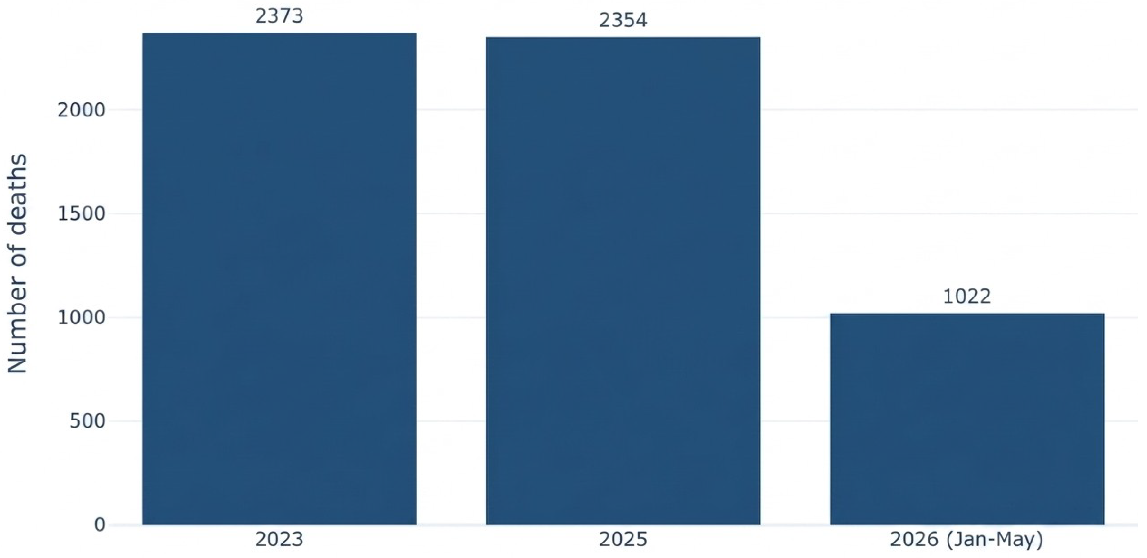
Figure 2.
Diagram of V2X intelligent-transportation urban applications.
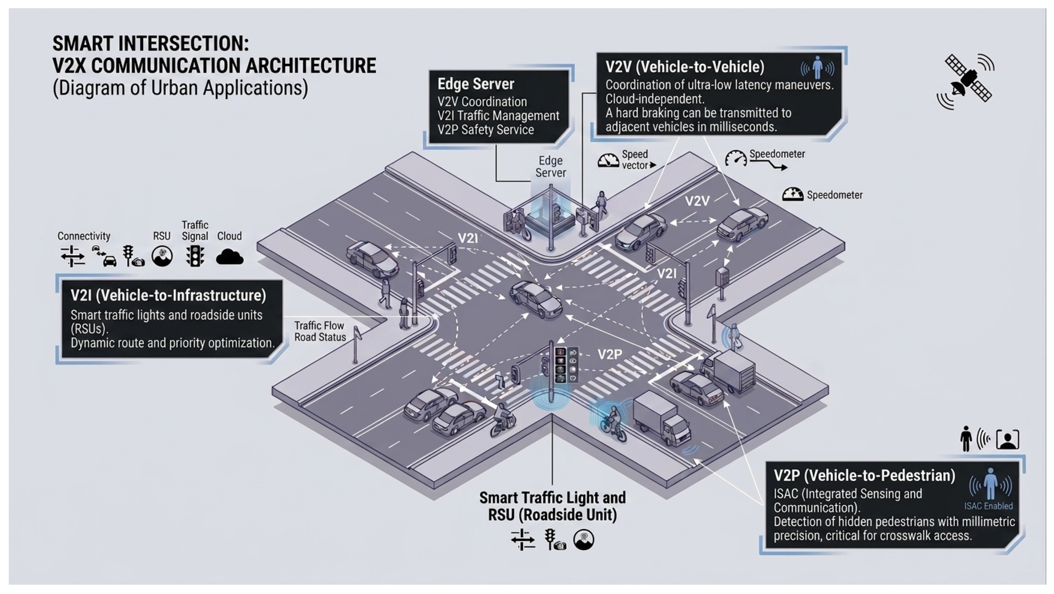
Figure 3.
End-to-end latency: Cloud vs. MEC in V2X communications.
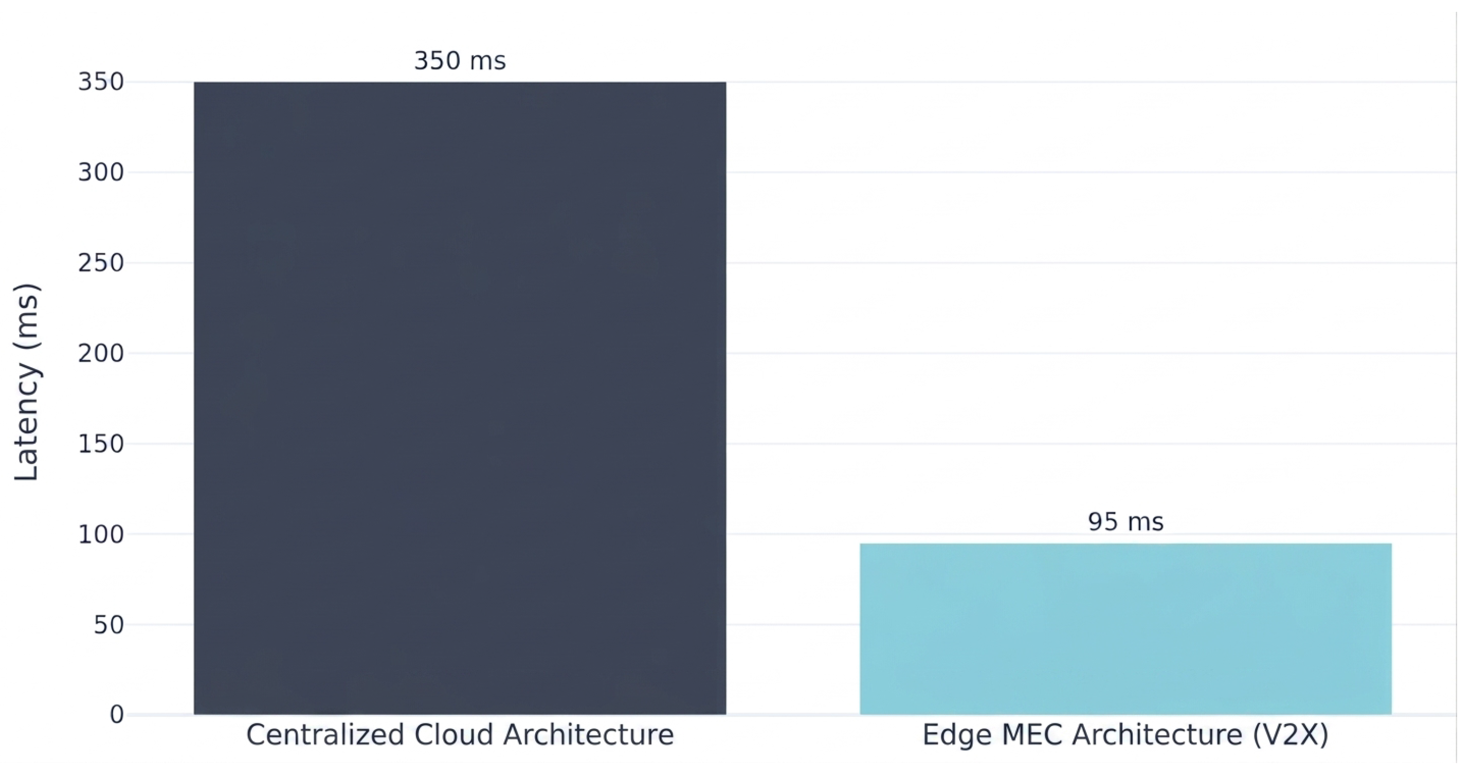
Figure 4.
Comparison of F1-score reported in the 2025-2026 literature between classical architectures and hybrid deep-learning architectures, quantitatively supporting the selection of the CNN-LSTM model.
Figure 4.
Comparison of F1-score reported in the 2025-2026 literature between classical architectures and hybrid deep-learning architectures, quantitatively supporting the selection of the CNN-LSTM model.
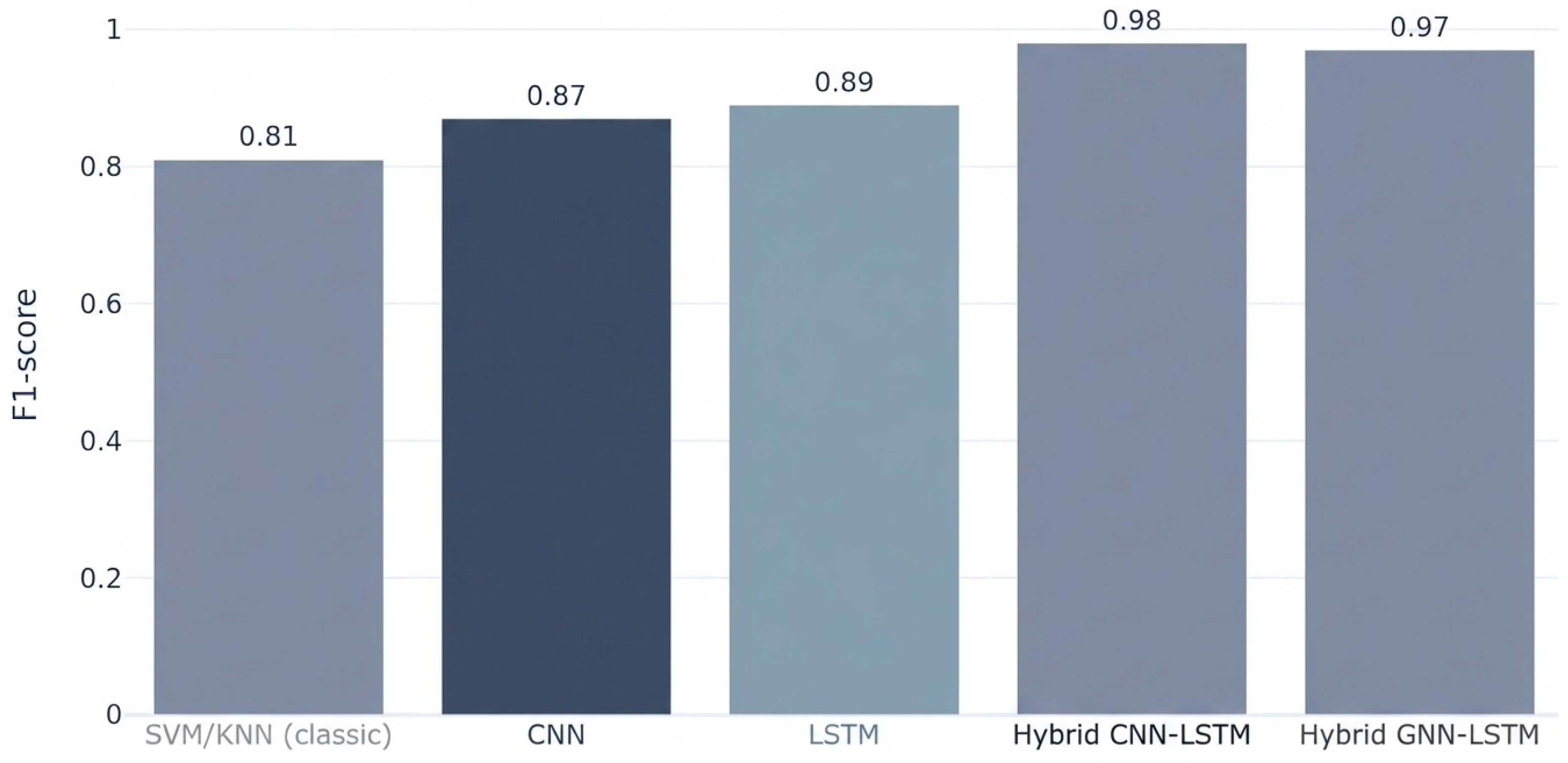
Figure 5.
Hybrid three-layer architecture of the IoV framework for accident prediction and prevention.
Figure 5.
Hybrid three-layer architecture of the IoV framework for accident prediction and prevention.
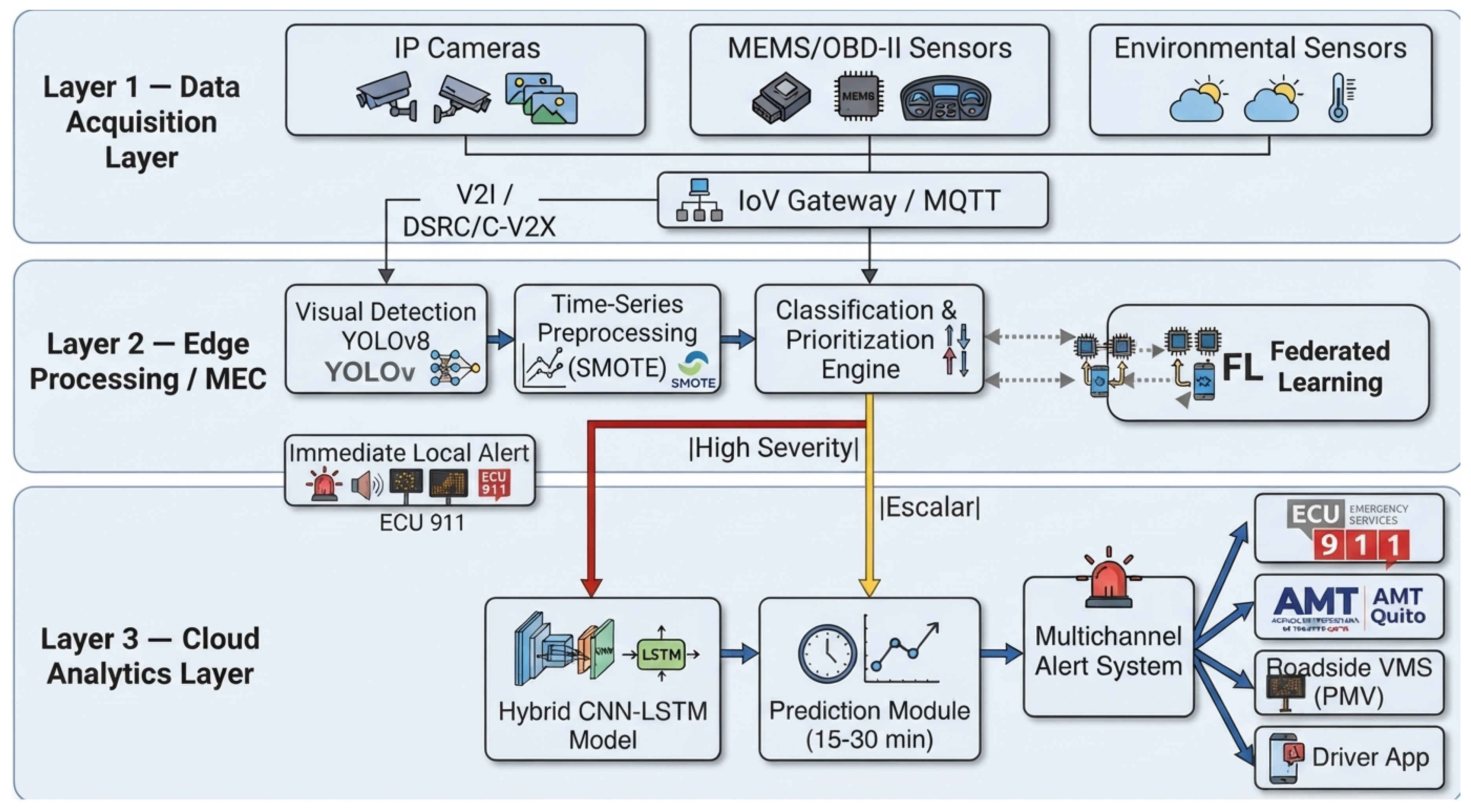
Table 1.
Institutional data sources for the IoV framework. Tables should be placed in the main text near the first time they are cited.
Table 1.
Institutional data sources for the IoV framework. Tables should be placed in the main text near the first time they are cited.
| Institution | Data type | Key statistical date (2025–2026) | Model input variable | Reference |
|---|---|---|---|---|
| INEC – ESTRA (Road Crash Statistics) | Statistical / Quarterly | Q1 2026: 4,789 crashes, 4,032 injured, 603 fatalities on-site –the highest quarterly figure in 3 years | Historical time series for supervised training of the predictive model | [40] |
| ANT – Open Data (National Transit Agency) | Georeferenced / Continuous | Jan–Oct 2025: 16,808 national crashes, 1,933 fatalities; Pichincha: 3,748 crashes and 369 fatalities | GPS crash location, road type, declared cause, weather condition, and time of day | [41] |
| ECU 911 (Integrated Security Service) | Operational / Real time | 2025: 3,239,683 national alerts; 397,775 Traffic and Mobility-related; peak hours 07:00–08:00 and 18:00–21:00 | Temporal emergency patterns for calibrating high-risk windows in the LSTM model | [42] |
| AMT – Quito (Metropolitan Transit Agency) | Road-specific / Operational | Gral. Rumiñahui Highway: 16 crashes Jan–Jun 2024, 2 fatalities; excessive speed as leading cause | Segment-disaggregated data + video streams from corridor cameras | [43] |
| MIT (Ministry of Infrastructure and Transport) | Infrastructure / Annual | As of end of 2025: 59% of the road network in regular or poor condition; roads in good condition dropped from 62% (2020) to 41% (2025) | Pavement condition and road geometry as contextual variables for the risk module | [44] |
| EPMMOP / Quito (Metropolitan Public Mobility and Public Works Company) | Road infrastructure / Annual | 2026 projection: intervention on 3,772.50 km of metropolitan road network (2023: 3,145.90 km; 2024: 3,640.00 km) | Road maintenance indicators conditioning the baseline risk level per segment | [45] |
Table 2.
Alignment of the proposed framework with international ISO standards.
| ISO Standard | Aligned Framework Component | Expected Indicator/Benefit |
|---|---|---|
| ISO 37106:2021 | Three-layer architecture as a “smart operating model” | Reduces silos between ANT, AMT, and ECU 911 through interoperable real-time data |
| ISO 37122:2019 | Risk-prediction module (Layer 3) | Indicator of intersections/segments with intelligent risk management |
| ISO 37122:2019 | Multichannel alert system (Layer 3) | Indicator of response time for prioritization and early-warning systems |
| ISO 37106:2021 | Federated Learning across edge nodes | “Smart data” principle without centralizing sensitive data |
Table 3.
Results of YOLOv8-based vehicle detection and monitoring models.
| Study | Model | Main Metric | Reported Value | Supporting Evidence |
|---|---|---|---|---|
| [54] | YOLOv8 + ByteTrack | mAP50 | 0.91 / 0.89 | Real CCTV evaluation at two sites, benchmarked against manual counts, with mean absolute error <3% |
| [47] | YOLOv8x | F1-score | 0.75 | Test on open webcams under uncontrolled conditions; robust evidence for visually noisy scenarios |
| [30] | Optimized YOLOv8 + virtual loops | Counting stability | Improvement over baseline | Experimental comparison of spatiotemporal counting against the baseline model in a complex urban environment |
| [55] | YOLOv8 | Congestion detection and severity | High classification performance | Real-time automated detection and categorization of vehicular congestion |
| [56] | YOLOv8 | Vehicle detection and classification | Improvement over traditional approaches | Real-time monitoring system with multi-category vehicle recognition |
| [51] | YOLOv8n | FPS | 52 FPS on Jetson Orin NX; 65 FPS with INT8 | Inference benchmark on an embedded GPU platform, useful for edge feasibility |
Table 4.
Comparison of deep-learning-based traffic accident prediction models.
| Source | Architecture / Study | Main Metric | Reported Value | Supporting Evidence |
|---|---|---|---|---|
| [22] | SVM / KNN | F1-score | 0.81 | Baseline performance used as a comparative reference against hybrid architectures. |
| [22] | CNN | F1-score | 0.87 | Improvement through spatial capture of the road pattern, but without explicit temporal memory. |
| [57] | LSTM | F1-score / high temporal precision | 0.89 | Improvement through modeling of temporal dependencies in traffic events. |
| [22] | CNN-LSTM | F1-score | 0.98 | Simultaneous integration of spatial and temporal features; best comparative performance. |
| [22] | GNN-LSTM | F1-score | 0.97 | Captures spatial relationships between road nodes and temporal risk dependencies. |
| [58] | LSTM for accident count | MSLE | 0.038671 | Annual prediction of accident count with two hidden layers and long-range temporal tuning. |
| [59] | LSTM-CNN for real-time crash risk | AUC / sensitivity / false alarms | Superior to alternative models | Comparison against XGBoost, Bayesian regression, and standalone LSTM for real-time road-risk prediction. |
| [60] | CNN-LSTM for accident frequency | Overall predictive performance | Better fit than simple models | Accident-frequency prediction in touristic and seasonal traffic scenarios. |
| [61] | Cascade LSTM + CNN model | Accident-impact prediction | Robust real-time performance | Model oriented toward early detection and evaluation of future accident impact. |
Table 5.
End-to-end latency evaluation in V2X architectures for critical alerts.
| Source | Architecture / Study | Approximate Latency | Compatible with Critical Alert (<150 ms) | Supporting Evidence |
|---|---|---|---|---|
| [48] | Centralized cloud | 300–400 ms | No | Remote processing and round-trip dependence on the cloud increase end-to-end latency. |
| [48] | Edge MEC | <100 ms | Yes | Local processing and reduced communication path enable a response compatible with critical events. |
| [46] | 5G V2N2V + MEC federation | <100 ms | Yes, under conditions | Feasible when local peering points and MEC federation exist between operators. |
| [62] | 5G deployment with MEC vs. cloud | Lower latency at the edge than in the cloud | Yes, depending on configuration | End-to-end modeling quantifying latency according to V2X service location. |
| [49] | FD-RAN + MEC | Additional latency reduction | Yes | Integration of decoupled radio access with MEC to optimize C-V2X latency. |
| [50] | ETSI MEC for V2X | Very low latency oriented to critical use cases | Yes | Regulatory and industry recommendation for local, real-time aggregation. |
Disclaimer/Publisher’s Note: The statements, opinions and data contained in all publications are solely those of the individual author(s) and contributor(s) and not of MDPI and/or the editor(s). MDPI and/or the editor(s) disclaim responsibility for any injury to people or property resulting from any ideas, methods, instructions or products referred to in the content. |
© 2026 by the authors. Licensee MDPI, Basel, Switzerland. This article is an open access article distributed under the terms and conditions of the Creative Commons Attribution (CC BY) license (http://creativecommons.org/licenses/by/4.0/).
Copyright: This open access article is published under a Creative Commons CC BY 4.0 license, which permit the free download, distribution, and reuse, provided that the author and preprint are cited in any reuse.