

Submitted:
11 August 2026
Posted:
12 August 2026
You are already at the latest version
Abstract
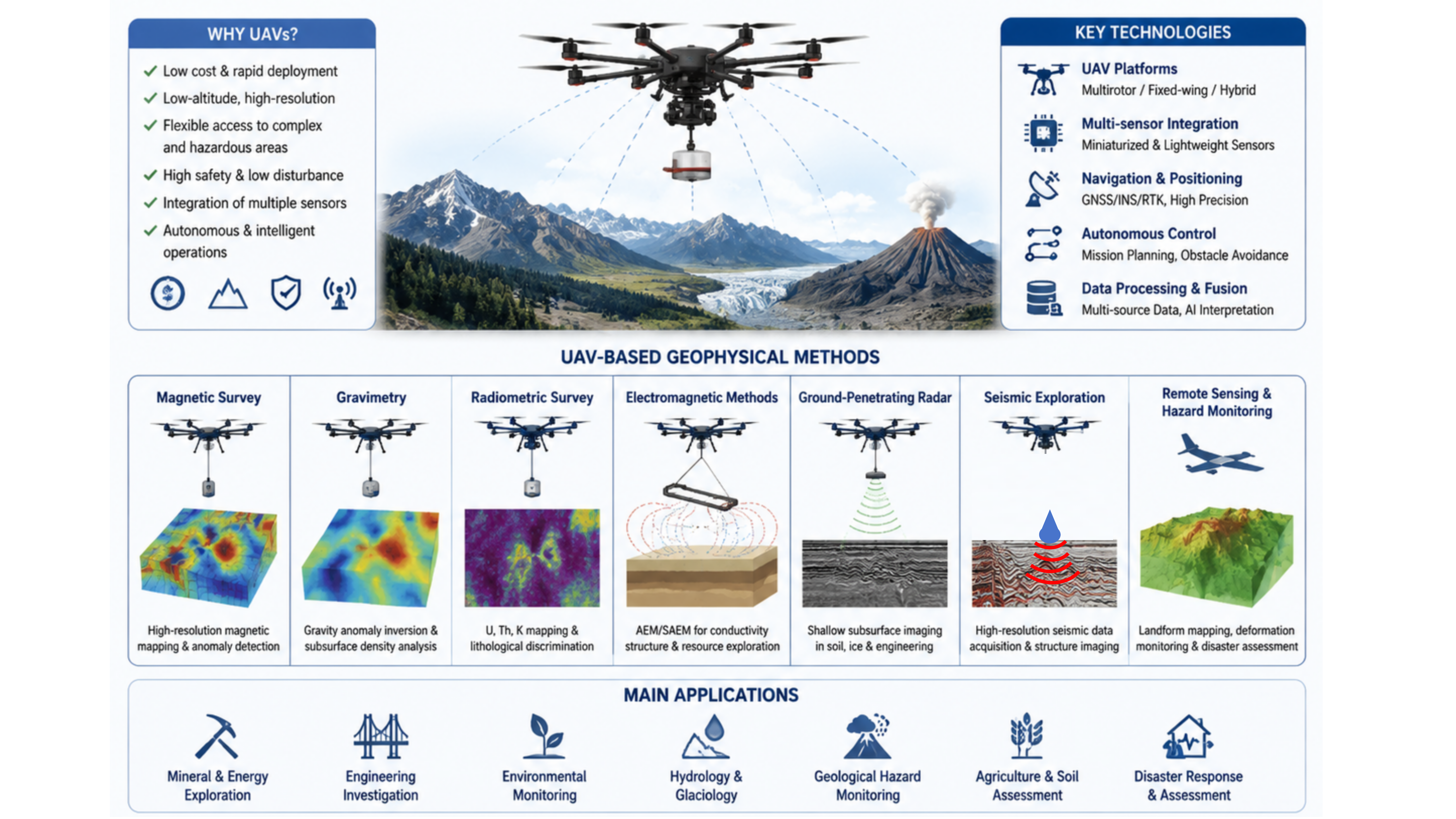
Unmanned aerial vehicles (UAVs) have gradually become an important technical platform for geophysical exploration because of their high mobility, low cost, adaptability to complex environments, and increasing capacity for autonomous operation. Conventional geophysical survey methods often face difficulties in equipment deployment, operational risk, and insufficient spatial resolution in mountain canyons, polar regions, volcanic areas, mining districts, and disaster-affected zones, whereas UAV platforms provide a new technical pathway for efficient, high-resolution, and low-disturbance geophysical observation. This review summarizes recent progress in UAV-based geophysical exploration, focusing on UAV platforms and intelligent control, UAV magnetic surveys, UAV gravimetry, UAV radiometric surveys, UAV electromagnetic surveys, UAV-based ground-penetrating radar, UAV seismic exploration, and UAV remote sensing for geological hazard monitoring. Although UAV geophysical exploration has made substantial progress, it still faces challenges related to payload capacity, sensor miniaturization, high-precision positioning, data quality control in complex environments, and multi-physics data fusion and interpretation.
Keywords:
UAV geophysics
; aeromagnetic surveying
; airborne electromagnetic methods
; UAV ground-penetrating radar
; UAV seismic exploration
1. Introduction
Geophysical exploration is an essential technical means for characterizing subsurface structures, supporting resource exploration, evaluating engineering conditions, and monitoring geological hazards. Conventional methods, including aeromagnetic surveying, airborne electromagnetics, seismic exploration, and ground-based remote sensing surveys, have developed into mature technical systems and have been widely applied in mineral resources, energy development, and geological-environmental research. However, in complex environments such as mountain canyons, densely forested areas, polar ice and snow regions, active volcanic areas, and hazardous disaster zones, conventional approaches remain constrained by difficult equipment transport, high operational costs, substantial personnel safety risks, and insufficient spatial resolution. Therefore, developing new survey platforms with rapid deployment capability, high spatial resolution, and adaptability to complex environments has become an important direction in geophysics [1,2].
With the development of UAV technology, miniaturized sensors, autonomous navigation, and intelligent control, UAVs have gradually evolved from conventional remote-sensing data-acquisition platforms into integrated geophysical exploration platforms. Compared with crewed airborne platforms, UAVs can fly at low altitude, maneuver flexibly, reduce operating costs, and enter hazardous areas. They therefore help bridge the technical gap between conventional airborne geophysical surveys and fine-scale ground investigations. In recent years, UAVs have been widely used in magnetic, electromagnetic, gravity, ground-penetrating radar (GPR), seismic, and remote-sensing monitoring applications, forming an integrated survey system centered on UAV platforms and multiple coordinated sensor types [3,4,5].
Although UAV geophysical exploration has developed rapidly in recent years, many challenges remain, including the trade-off between UAV payload capacity and sensor performance, flight stability in complex environments, insufficient data quality-control methods for different sensors, and limited capability for multi-physics information fusion and interpretation. A systematic summary of the current development status, key problems, and future trends of UAV geophysical exploration is therefore important for promoting its deeper application in resource exploration, engineering safety, and geological hazard monitoring.
This review focuses on UAV platforms and intelligent control technologies, together with the major application directions of magnetic, gravity, radiometric, electromagnetic, GPR, seismic, and remote-sensing monitoring. It summarizes recent progress in UAV-based geophysical exploration, analyzes existing problems, and discusses future trends toward intelligent, multi-source, and autonomous exploration.
3. UAV-Based Magnetic Surveys
Aeromagnetic surveying is an important geophysical technique in which an airborne platform carries a magnetometer to acquire spatial variations in the Earth’s magnetic field. It is widely used in mineral-resource exploration, volcanic-activity monitoring, structural interpretation, and engineering geological investigations. Conventional crewed aeromagnetic systems are often expensive, constrained in flight altitude, insufficiently adaptable to complex terrain, and unable to meet the spatial-resolution requirements of fine-scale surveys. With the development of UAV platforms, miniaturized high-sensitivity magnetic sensors, and autonomous flight-control technology, UAV-based aeromagnetic exploration has become an important technical direction for high-resolution, small-scale magnetic-anomaly surveys [3,24,25].
Early UAV aeromagnetic studies focused mainly on platform feasibility and system integration (Figure 1). Caron et al. first systematically discussed the feasibility of aeromagnetic surveying using UAV systems and evaluated flight stability, payload capacity, and magnetic-survey accuracy using a simulated UAV platform, thereby laying the foundation for subsequent UAV aeromagnetic systems [24]. Funaki et al. and Koyama et al. used small UAVs and unmanned autonomous helicopters to conduct aeromagnetic experiments in Antarctic and volcanic regions, respectively, demonstrating the advantages of UAV platforms in extreme environments and hazardous magnetic-anomaly surveys [26,27]. Hashimoto et al. and Pei et al. further developed unmanned autonomous helicopter aeromagnetic systems, achieved high-resolution magnetic-field measurements in volcanic areas, and analyzed the effects of platform attitude variation, flight altitude, and magnetic-sensor performance on data quality [28,29].
One core technical issue in UAV aeromagnetic systems is the suppression of platform magnetic interference and the optimization of sensor deployment. UAV motors, batteries, electronic control modules, and mechanical structures can all generate magnetic-field interference; therefore, high-precision weak-anomaly detection remains a limiting factor in UAV aeromagnetic applications. Zheng et al. reviewed UAV platform selection, sources of magnetic interference, and suppression methods, emphasizing that non-magnetic materials, optimized sensor-installation positions, and magnetic compensation are critical for improving measurement accuracy [3]. Krishna et al. conducted magnetic-interference experiments on a hybrid UAV platform and quantitatively analyzed magnetic-noise characteristics under different flight states and equipment operating modes [30]. Døssing et al. designed a lightweight high-speed scalar magnetometer bird and investigated sensor selection, bird structure, and data-quality control, providing a new technical solution for kilometer-scale UAV magnetic surveys [31]. Calou and Munschy further studied inversion of UAV magnetic-survey data and demonstrated the feasibility of determining the magnetization structure of magnetic sources from UAV-acquired magnetic anomalies [32].
As system stability has improved, UAV aeromagnetic technology has gradually shifted from method validation to resource exploration and fine-scale geological investigation. Parshin et al. proposed the use of multirotor UAVs as a replacement for traditional ground magnetic surveys, noting that low-altitude UAV magnetometry can provide higher spatial resolution and better environmental adaptability in complex terrain [33]. De Smet et al. applied drone-based aeromagnetic surveys to locate legacy oil and gas wells, showing the value of UAV magnetic methods in near-surface infrastructure and environmental investigations [34]. Le Maire et al. used a UAV equipped with a fluxgate magnetometer for rapid aerial magnetic mapping and explored upscaling from local field surveys to regional magnetic-anomaly characterization [35]. Walter et al. conducted high-resolution UAV aeromagnetic surveys for mineral-exploration targets and demonstrated that UAV platforms can effectively identify shallow magnetic anomalies [36]. Cunningham et al. carried out rotary-wing UAV aeromagnetic experiments in zinc and gold exploration in Canada and combined magnetic-anomaly inversion with UAV data to predict ore-body location and magnetization characteristics [37,38]. Jiang et al. developed an aeromagnetic measurement system based on a UAV platform and successfully applied it to exploration of the Ma’anshan magnetite deposit, verifying the potential of UAV aeromagnetics in iron-ore surveys [39]. Porras et al. applied UAV magnetometry to Triassic Cu-Co-Ni mineralization in Spain, further expanding its application to polymetallic mineral exploration [40].
In recent years, UAV aeromagnetics has increasingly been integrated with multi-source remote sensing and three-dimensional geological modeling, promoting its development toward integrated geological investigation. Jackisch et al. combined UAV magnetic data with multispectral remote-sensing data to map a carbonatite-hosting outcrop in Finland, enabling the fusion of geological, mineralogical, and magnetic-anomaly information [41]. Subsequently, Jackisch et al. conducted combined UAV magnetic and multispectral surveys at Qullissat, Greenland, and developed a three-dimensional model for mineral exploration [42]. Accomando et al. demonstrated that UAV aeromagnetics can provide clear advantages over conventional airborne and ground surveys in extremely rugged terrain, allowing high-precision magnetic-anomaly acquisition in complex topographic settings [43]. Tada et al. and Romero-Toribio et al. used UAV magnetic surveys to investigate volcanic magnetization structures and post-eruptive shallow structural changes, respectively, highlighting the value of UAV aeromagnetics for volcanic monitoring [44,45].
New sensors and system integration have further promoted UAV aeromagnetic development. Okuma et al. applied UAV magnetic surveying to identify hydrothermal alteration zones related to landslide hazards at Aso Volcano, Japan, providing a new technical means for hazardous-slope investigation [46]. Deng et al. developed a vertical magnetic-gradient detection system for a four-rotor UAV, improving the recognition capability for shallow magnetic anomalies [47]. Takáč et al. used UAV-based magnetometry to investigate potential magnetic signatures in the Tunguska event impact area, expanding UAV magnetometry into the study of special geological events [48]. Accomando et al. compared the MagNimbus and MagArrow UAV magnetometer systems, contributing to the standardization of UAV magnetic equipment [49]. Zhang et al. developed a UAV aeromagnetic system based on a fluxgate sensor and conducted application tests, providing a technical foundation for UAV aeromagnetic system development [50].
UAV aeromagnetic exploration has progressed from early platform validation to high-resolution, multi-source, and intelligent applications. Current research focuses mainly on three aspects: (1) lightweight, high-sensitivity magnetic sensors and low-magnetic-interference UAV platform design; (2) flight-attitude control, magnetic compensation, and data quality-control technologies in complex environments; and (3) UAV magnetic-anomaly inversion, multi-source geoscience information fusion, and three-dimensional geological interpretation. With advances in artificial intelligence, automatic route planning, and multi-physics joint exploration, UAV aeromagnetics is expected to become an important method for resource exploration and geological-hazard investigation in complex areas.
4. UAV-Based Gravimetry
Airborne gravimetry is an important geophysical technique for acquiring regional gravity-field information, investigating deep structures, and supporting resource exploration. Conventional airborne gravity systems usually rely on crewed aircraft and are therefore limited by high cost, flight constraints, and insufficient adaptability to low-altitude operations in complex areas. With the development of UAV platforms, high-precision inertial navigation systems, and miniaturized gravity sensors, UAV airborne gravimetry has gradually become an important direction for low-altitude and high-resolution gravity-field exploration.
Research on UAV airborne gravimetry initially focused on system feasibility and platform integration. Kaub et al. developed an autonomous unmanned aerial system for estimating terrain-correction parameters in gravity measurements, demonstrating that UAV platforms can effectively assist gravity surveys in complex areas and improve field-survey efficiency [51]. Luo et al. realized the first application of a UAV airborne gravimetry system in China based on the CH-4 UAV. By integrating a high-precision gravimeter, GNSS positioning, and a flight-control system, they verified the feasibility of carrying airborne gravity equipment on a large UAV platform for regional gravity measurement, laying a foundation for domestic UAV airborne gravimetry technology [52].
With sensor development, UAV airborne gravimetry has gradually moved toward high-precision and high-dynamic measurement. Traditional stabilized-platform airborne gravimeters can achieve high accuracy, but their structural complexity and relatively large volume restrict their use on UAVs. Strapdown airborne gravimetry has therefore attracted increasing attention. Golovan and Vyazmin summarized airborne-gravity survey methodology and strapdown-gravimeter data-processing workflows and proposed data-processing approaches applicable to aircraft and UAV platforms [53]. Vyazmin and Golovan further discussed technical routes for scalar and vector strapdown airborne gravimetry on aircraft and UAVs, providing a theoretical basis for future miniaturized airborne gravity systems [54]. Johann et al. compared stable-platform and strapdown airborne gravimeters and noted that strapdown systems have simpler structures and stronger dynamic adaptability, which makes them more suitable for UAV applications [55].
The key challenges in UAV airborne gravimetry lie in flight-dynamic disturbances, GNSS errors, and the separation of gravity signals from platform-motion noise. To address these problems, Wang et al. proposed a Kalman-FIR fusion-filtering method for high-dynamic airborne-gravity data processing and verified its noise-suppression capability using the GIPS-1A system [56]. Arkhipova and Vyazmin further investigated Kalman filtering based on a refined GNSS error model, improving navigation-error compensation in strapdown airborne gravimetry [57]. In addition, cold-atom gravity sensing has further promoted accuracy improvements in airborne gravimetry. Vu et al. investigated the potential of cold-atom airborne gravimetry for coastal gravity-field and quasigeoid modeling, showing that next-generation quantum sensing can substantially improve the precision and stability of airborne-gravity measurements [58].
UAV airborne gravimetry is currently transitioning from system validation toward engineering application. With the development of quantum sensing, artificial-intelligence filtering, and autonomous flight technologies, UAV airborne-gravity systems are expected to become an important supplement to conventional airborne gravimetry and to provide new technical support for deep-structure exploration and resource-environment investigation in complex areas.
5. UAV-Based Radiometric Surveys
Airborne radiometric surveying uses airborne platforms carrying gamma-ray spectrometers, nuclear-radiation detectors, and related instruments to acquire the spatial distribution of natural radionuclides at the Earth’s surface. It is an important method in geophysics and environmental monitoring and is widely applied in uranium-resource exploration, nuclear-contamination monitoring, environmental assessment, and geological mapping. Conventional crewed airborne radiometric surveys can rapidly cover large areas, but they are limited by high flight costs, insufficient low-altitude fine-scale detection capability, and operational constraints in complex areas. With the development of miniaturized gamma-ray detectors, UAV platforms, and autonomous flight-control technology, UAV airborne radiometric surveying has gradually become an important technical direction for low-altitude, high-resolution, and complex-environment radiation surveys.
Early UAV airborne radiometric studies mainly addressed system integration and application feasibility. MacFarlane et al. developed lightweight aerial vehicles for monitoring, assessment, and mapping of radiation anomalies, systematically demonstrating the potential of small UAVs for low-altitude radiation surveys [59]. Salek et al. used a UAV mini-airborne gamma-ray spectrometry system to map radiation anomalies and acquired high-resolution spatial distributions of natural radioactive elements [60]. Parshin et al. compared low-altitude UAV gamma measurements with terrestrial and conventional airborne gamma-survey data, verifying the reliability of UAV platforms in regional radiation surveys and showing that low-altitude flight can improve anomaly recognition [61].
With improvements in detector performance and data-processing methods, UAV airborne radiometric technology has gradually advanced toward quantification and standardization. Van der Veeke et al. optimized UAV-borne gamma-ray spectrometers for geophysical applications and analyzed the relationships among detector size, energy resolution, and system weight, providing a basis for designing high-performance lightweight gamma spectrometers [62]. To address spatial-response differences caused by UAV flight-height variation, van der Veeke et al. further studied footprint and height corrections in UAV-borne gamma-ray spectrometry, improving quantitative interpretation of radiometric anomalies under different flight conditions [63].
In recent years, UAV airborne radiometric surveying has been extended to complex environmental monitoring and resource exploration. Kunze et al. developed a UAV-based gamma-spectrometry system for natural radionuclides and carried out field tests at Central Asian uranium legacy sites, achieving high-precision investigation of uranium-related radiometric anomalies [64]. Altfelder et al. studied the upscaling of ground-based backpack gamma-ray spectrometry to the spatial resolution of UAV-based gamma-ray spectrometry, enabling validation and fusion across observation scales [65]. Ji et al. conducted wide-area UAV airborne gamma-ray spectrometry for contaminated-site monitoring, demonstrating that UAV platforms can rapidly acquire spatial distributions of radioactivity in contaminated areas and improve environmental-radiation survey efficiency [66].
UAV airborne radiometric surveying has evolved from early equipment validation into a new airborne geophysical technology system that integrates lightweight detectors, high-precision flight control, multi-parameter correction, and intelligent data interpretation. Current key scientific and technical issues include the development of compact high-sensitivity spectrometers, height and attitude correction under complex flight conditions, fusion of multi-source radiation information, and optimization of quantitative inversion methods.
6. UAV-Based Electromagnetic Surveys
The airborne electromagnetic method (AEM) uses an airborne platform carrying electromagnetic transmitting and receiving systems to support resource exploration and engineering investigation by measuring conductivity contrasts in subsurface media. Conventional AEM systems mainly rely on fixed-wing aircraft or helicopter platforms and can achieve high survey efficiency and broad coverage, but they also involve heavy equipment, high operating costs, and limited adaptability to complex terrain. With improvements in UAV payload capacity, miniaturized electromagnetic sensors, and autonomous flight control, UAV-based AEM has gradually become an important direction for shallow high-resolution exploration and geophysical investigation in complex environments. In particular, semi-airborne electromagnetic (SAEM) technology, which combines UAV low-altitude flight with high-power ground transmitters, has become an active research focus in recent years(Figure 2).
Early UAV electromagnetic studies focused mainly on system feasibility and miniaturized equipment development. Eröss et al. first conducted very-low-frequency (VLF) electromagnetic measurements using an unmanned aerial system and analyzed UAV electromagnetic responses using two-dimensional conductivity models, demonstrating the potential of UAV platforms for low-altitude electromagnetic exploration [67]. Pirttijärvi et al. developed a drone-based electromagnetic survey system for geophysical applications and analyzed key technical issues, including payload limitations, flight stability, and electromagnetic-noise control [68]. Mitsuhata et al. developed a drone-borne electromagnetic survey system and applied it to buried-object search and soil-resistivity mapping, verifying the effectiveness of UAV electromagnetic methods for shallow engineering investigations [69].
With the integration of UAV platforms and transient electromagnetic (TEM) technology, semi-airborne electromagnetic exploration has gradually formed a new technical system. Wu et al. summarized the development and applications of SAEM systems in China and noted that SAEM, by combining high-power ground transmitters with airborne receiving platforms, can balance greater detection depth with adaptability to complex terrain [70]. Lin et al. reviewed technological innovation in SAEM methods, and related reviews of helicopter time-domain AEM further promoted the extension of semi-airborne approaches toward deep resource exploration [71,72]. The DESMEX system proposed by Becken et al. uses UAVs or lightweight airborne platforms carrying receivers to detect deep electrical structures in complex environments [73]. Steuer et al. integrated geological, petrophysical, and multi-scale geophysical data to interpret DESMEX results, verifying the applicability of semi-airborne electromagnetic data under complex geological conditions [74].
In recent years, multirotor UAVs have gradually become important carriers for semi-airborne electromagnetic systems. Stoll et al. investigated the feasibility of using a multicopter to carry a semi-airborne electromagnetic receiver and demonstrated the advantages of UAVs in low-speed, low-altitude, and highly maneuverable operations [75]. Kotowski et al. conducted a semi-airborne electromagnetic survey using a multicopter system and analyzed the effects of flight altitude, attitude variation, and system noise on measurement quality [76]. Subsequently, Kotowski et al. applied UAV-towed magnetometers to semi-airborne electromagnetic exploration of deep sulfide deposits and focused on processing and three-dimensional modeling methods, further extending UAV-based SAEM to mineral-resource investigation [77].
One key challenge for UAV airborne electromagnetics is data processing, three-dimensional modeling, and noise suppression in complex environments. Hui et al. proposed an efficient three-dimensional frequency-domain SAEM modeling method based on domain decomposition, improving computational efficiency under complex model conditions [78]. Hui et al. further developed a decoupled-mesh three-dimensional inversion method for semi-airborne transient electromagnetic data, improving three-dimensional interpretation capability [79]. Ma et al. investigated the optimal survey area of the semi-airborne TEM method, providing a theoretical basis for practical line design and survey-range optimization [80]. Shi et al. and Liu et al. used three-dimensional numerical simulations to study the influence of grounded-source geometry and source shape on semi-airborne transient electromagnetic responses, revealing the importance of source-parameter design for detection accuracy [81,82].
Several breakthroughs have also been achieved in engineering applications under complex terrain. Sun et al. first applied semi-airborne transient electromagnetic surveying to tunnel investigation in very complex terrain, enabling rapid subsurface-structure investigation under challenging topographic conditions [83]. Wu et al. used loop-source semi-airborne transient electromagnetics for exploration in the shallow-cover area of East Tianshan, Xinjiang, improving ore-body recognition in complex covered terrain [84]. Su et al. applied high-resolution semi-airborne electromagnetic imaging to constrain water-rich areas in the Huangling Coal Mine, enabling detailed characterization of underground water-risk zones [85].
With the development of artificial intelligence, intelligent data processing has become an important direction in UAV airborne electromagnetics. Lin et al. proposed a recurrent self-encoding neural network for semi-airborne electromagnetic line-signal denoising, improving weak-signal recognition [86]. Wang et al. developed DREMnet, an interpretable denoising framework for semi-airborne transient electromagnetic signals, providing a new technical route for automated data processing in complex environments [87]. In addition, Zhang et al. developed SATEM, a drone-based semi-airborne transient electromagnetic receiver system, achieving deep integration between UAV platforms and TEM technology [88]. Cheng et al. investigated multi-elevation UAV-based frequency-domain electromagnetic measurements for data calibration and field investigation, improving the reliability of UAV electromagnetic data [89]. Barsukov et al. studied the feasibility of UAV-based mobile pulsed electromagnetic soundings, expanding the potential of UAV electromagnetic exploration for deeper structural investigation [90].
UAV airborne electromagnetic exploration has developed from early miniaturized-equipment validation into a new geophysical technology system integrating UAV platforms, semi-airborne electromagnetic systems, three-dimensional inversion, and artificial-intelligence processing. The field still faces challenges in electromagnetic-interference control, flight-attitude correction, high-precision three-dimensional inversion, and adaptability to complex terrain. With the development of high-sensitivity sensors, autonomous flight, multi-physics fusion, and intelligent inversion, UAV airborne electromagnetics will play an increasingly important role in mineral-resource exploration, groundwater investigation, engineering-safety evaluation, and deep-structure exploration in complex areas.
7. UAV-Based Ground-Penetrating Radar
Ground-penetrating radar (GPR) is a non-destructive geophysical method that uses high-frequency electromagnetic waves to detect the structure of subsurface media. It is widely applied in underground-target identification, soil-moisture monitoring, snow and glacier-structure investigation (Figure 3), disaster assessment, and engineering-geological exploration. Conventional ground GPR systems usually rely on manual dragging or vehicle mounting and are limited by terrain adaptability, near-surface coupling requirements, and low operational efficiency in complex environments. With the development of UAV platforms, ultrawideband antennas, miniaturized radio-frequency systems, and high-precision positioning, UAV-based GPR has gradually become an important direction for high-resolution subsurface detection in complex areas.
The development of UAV-GPR technology first focused on system integration and platform feasibility. Ludeno et al. used a micro-UAV carrying a microwave tomography radar system to conduct experimental research, showing that UAV platforms can overcome the contact-measurement limitations of conventional GPR and achieve non-contact three-dimensional radar imaging [91]. López et al. systematically reviewed UAV-based GPR systems and noted that UAV platforms provide low-altitude flexible flight, strong adaptability to complex terrain, and high spatial resolution. They also summarized key issues including UAV payload limitations, antenna design, flight stability, and data processing [4]. Grathwohl et al. further summarized the development status of multicopter UAV-based ground-penetrating imaging radars and emphasized that lightweight radar systems and autonomous flight control are core technologies for engineering application [92].
A key technology in UAV-GPR systems is the design of lightweight and high-performance radar hardware. Colorado et al. developed a UAV-GPR system based on software-defined radio (SDR) and applied it to landmine detection, achieving integration between autonomous UAV platforms and GPR technology [93]. Wu et al. developed a drone-borne GPR system for soil-moisture mapping and verified the capability of UAV platforms for rapid large-area soil-parameter investigation [94]. Guo et al. further studied the design and implementation of a GPR system based on a UAV platform, promoting engineering application of UAV-GPR [95].
An important advantage of UAV-GPR is its ability to perform high-resolution subsurface-structure investigation in complex environments. Jenssen et al. used a drone-mounted ultrawideband radar to retrieve snowpack properties, enabling the acquisition of snow thickness and internal structural parameters [96]. Valence et al. and Vergnano et al. applied drone-based GPR to snow hydrology and snow-cover mapping, respectively, improving the efficiency of snow-parameter acquisition in cold regions [97,98]. Cheng et al. further used UAV-based GPR for combined measurement of soil permittivity and electrical conductivity, enabling integrated inversion of soil-water parameters and providing a new technical means for agricultural hydrology and environmental monitoring [99].
With advances in UAV flight control and radar-imaging algorithms, UAV-GPR has gradually progressed from two-dimensional detection toward high-precision three-dimensional imaging. García-Fernández et al. proposed improved focusing methods for GPR synthetic-aperture-radar (GPR-SAR) imaging in UAV-mounted GPR systems, improving target-detection capability and spatial resolution [100]. Chi et al. studied airborne GPR imaging in complex terrain, further improving the applicability of UAV-GPR in mountainous and irregular areas [101].
UAV-based GPR has developed from early platform integration and feasibility validation to lightweight equipment, high-precision imaging, and intelligent interpretation. Current challenges include wavefield distortion caused by flight-attitude variation, signal attenuation under air-coupled conditions, quantitative interpretation in complex media, and automated data processing. With the development of ultrawideband antennas, miniaturized high-dynamic radar systems, three-dimensional SAR-GPR imaging, and artificial-intelligence-assisted interpretation, UAV-GPR will play an increasingly important role in landslide-hazard investigation, underground-infrastructure detection, snow hydrology, and resource-environment monitoring.
8. UAV-Based Seismic Exploration
UAV-based seismic exploration is a new technical direction in active-source seismic exploration. Its core idea is to use UAV platforms carrying artificial seismic sources or auxiliary seismic-acquisition equipment to achieve rapid, flexible, and low-cost active-source seismic surveys under complex environmental conditions. Compared with conventional explosive sources, vibroseis sources, and manually operated weight-drop sources, UAV seismic technology offers flexible deployment, low environmental impact, reduced personnel risk, and strong adaptability to complex terrain. It is therefore especially suitable for mountain canyons, vegetated areas, traffic-restricted regions, and disaster-investigation scenarios where conventional seismic operations are difficult.
The development of UAV seismic technology first focused on the design of UAV seismic-source systems and evaluation of excitation capability. Ma et al. proposed a UAV source technology in which a UAV platform carries an impact source (Figure 4), providing a new active-source method for seismic exploration in complex areas [102]. Their study analyzed the advantages of UAV sources in construction efficiency, environmental impact, and adaptability to complex terrain, showing that UAV sources can compensate for the limitations of conventional sources in mountainous and special environments. Ma et al. further studied the aerodynamic response and shotpoint-position accuracy of UAV seismic sources, focusing on hover stability, flight-attitude variation, and the influence of source release on excitation-position error. Their results verified the feasibility of UAV sources for high-precision active-source seismic acquisition [103].
In terms of UAV-source energy mechanisms, airborne-platform-assisted active-source technology provides an important reference for UAV seismic development. Jolly et al. proposed the use of high-impact mass drops from a helicopter as an active seismic source and successfully applied the method in an active volcanic setting, demonstrating the potential of aerial impact sources for active exploration in complex areas [104]. Based on a similar concept, UAV seismic sources further miniaturize and automate the source platform, providing a new technical pathway for seismic-data acquisition in hazardous or difficult-to-access areas.
With the development of UAV autonomous-control technology, research has gradually expanded from single-UAV sources to cooperative multi-UAV acquisition systems. Timoshenko et al. proposed seismic data acquisition using a group of UAVs, in which multiple UAVs cooperatively perform source excitation, receiver deployment, and survey-line coverage, improving seismic-survey efficiency in complex areas [105]. Alqahtani et al. further proposed an autonomous near-surface characterization mode involving cooperative joint missions between seismic recording and surveying UAVs. This approach enables task allocation and joint operation among UAV platforms and provides a new direction for future unmanned seismic-acquisition systems [106].
In recent years, UAV seismic technology has been applied to engineering-geological investigation and fine-scale imaging in complex mountainous areas. Greenwood et al. used UAV-enabled multichannel analysis of surface waves (MASW) for subsurface characterization, verifying the value of UAV platforms in near-surface geophysical-parameter acquisition [107]. Zhang et al. combined a UAV seismic source with supervirtual refraction interferometry (SVI) for mountain-tunnel hazard assessment. By enhancing far-offset refraction signals, the approach improved first-arrival picking quality and shallow velocity-model accuracy [108]. Zhang et al. further studied robust source-signature estimation for mixed-source seismic data in the complex Yarlung Zangbo River valley, providing technical support for seismic modeling and imaging under UAV-source conditions in complex terrain [109].
Overall, UAV seismic technology has evolved from early source-feasibility validation into a new active-source seismic technology system integrating UAV source design, precise shotpoint positioning, autonomous flight control, multi-UAV cooperative acquisition, and high-precision seismic processing and imaging. The field still faces key challenges in source-energy enhancement, surface-coupling stability, flight-safety control, shotpoint repeatability, and data-quality assurance in complex environments. Future work will focus on high-payload long-endurance UAV platforms, highly repeatable impact sources, joint UAV-node seismometer/DAS observation systems, and real-time intelligent quality-control technologies, promoting UAV seismic exploration toward automation, intelligence, and deep exploration in complex areas.
9. UAV Remote Sensing and Geological Hazard Monitoring
UAV remote sensing is a rapidly developing high-resolution spatial-information acquisition technology. By carrying visible-light cameras, multispectral sensors, thermal-infrared cameras, LiDAR, and multi-source geophysical sensors, UAVs can acquire data rapidly, accurately, and at low cost in complex areas. Compared with satellite remote sensing and crewed airborne remote sensing, UAVs provide high spatial resolution, strong timeliness, flexible operation, and prominent low-altitude near-ground observation capability. They have been widely applied in geological-hazard investigation, landslide monitoring, volcanic-activity analysis, underground-engineering safety evaluation, and ecological-environment monitoring. With the development of photogrammetry, three-dimensional reconstruction, artificial intelligence, and multi-source data fusion, UAV remote sensing has gradually shifted from single-image acquisition toward dynamic monitoring, intelligent recognition, and hazard-risk assessment.
Early applications of UAV remote sensing in geological-hazard investigation focused mainly on landslide-morphology mapping and displacement monitoring. Niethammer et al. used UAV remote sensing to investigate the Super-Sauze landslide in France, constructing a high-precision terrain model and analyzing landslide-deformation characteristics, thereby demonstrating the potential of UAV photogrammetry in landslide research in complex mountainous areas [110]. Lucieer et al. combined structure-from-motion (SfM) methods with multi-temporal UAV imagery to automatically extract landslide displacement fields, providing a new method for high-frequency, small-scale landslide-deformation monitoring [111]. Turner et al. further used UAV time-series photogrammetry to analyze landslide dynamics and achieve continuous deformation monitoring [112]. Lindner et al., Rossi et al., and Ma et al. conducted UAV monitoring of large landslides, mountainous landslides, and complex-terrain landslides, respectively, revealing the advantages of UAV remote sensing for analyzing landslide geometry, kinematic mechanisms, and failure evolution [113,114,115].
As UAV multi-temporal data-acquisition capability has improved, its application in dynamic hazard monitoring and risk evaluation has deepened. Barlow et al. used UAV photogrammetry to analyze sea-cliff stability and identify rock-mass discontinuities and local deformation features [116]. Xu et al. conducted large-area monitoring of the Heifangtai landslides on the Loess Plateau using multi-temporal UAV photogrammetry, extracting landslide boundaries, crack expansion, and surface deformation [117]. Suh and Choi used UAV photogrammetry to identify mining-induced ground subsidence, providing a new technical approach for mining geological-hazard monitoring [118]. Kim et al. combined rainfall-process analysis with UAV-derived slope-displacement time series and revealed the relationship between rainfall intensity and landslide-deformation response [119]. Sun et al. systematically reviewed UAV applications in landslide investigation and monitoring and noted that UAVs have become an important supplement to traditional geological investigation and long-term monitoring [5].
In addition to visible-light photogrammetry, multi-sensor fusion has promoted UAV remote sensing toward integrated geological-information acquisition. Thermal-infrared remote sensing can effectively identify groundwater activity, thermal anomalies, and volcanic-activity areas. Harvey et al. used a UAV carrying a thermal-infrared camera to investigate the Waikite geothermal area in New Zealand and produced high-resolution maps of surface thermal anomalies [120]. Nishar et al. conducted UAV thermal-infrared surveys in the Wairakei-Tauhara geothermal field, demonstrating that UAV thermal imaging can effectively identify zones of geothermal-fluid activity [121]. Lee et al. applied UAV thermal-infrared mapping to coastal groundwater discharge and achieved detailed identification of groundwater anomalies [122]. Walter et al. combined UAV photogrammetry and underwater imaging to study the structure of the Geysir geothermal field in Iceland and revealed spatial controls in a volcano-hydrothermal system [123]. Wakeford et al. combined thermal-infrared imagery with photogrammetry for monitoring activity at Stromboli volcano in Italy, improving the ability to identify volcanic-hazard zones [124]. Granados-Bolaños et al. demonstrated the value of low-cost UAVs for dynamic monitoring of tropical volcanic landforms [125].
Important progress has also been made in geological-structure recognition and engineering-safety evaluation using UAV remote sensing. Vasuki et al. proposed a semi-automatic method for mapping geological structures from UAV photogrammetric data and achieved automatic extraction of faults, fractures, and related structural information [126]. Madjid et al. discussed the opportunities and challenges of UAVs in carbonate geology and successfully applied them to dolomite geobody mapping [127]. Turner et al. used UAV thermal and multispectral imagery to identify potentially adverse discontinuities in underground excavations, improving underground-space stability evaluation [128].
In recent years, LiDAR development has further enhanced the three-dimensional measurement capability of UAV remote sensing. França Pereira et al. compared UAV LiDAR and photogrammetry-derived data for landslide-susceptibility mapping and showed that LiDAR can improve the accuracy of terrain-information acquisition in complex vegetated areas [129]. Yang et al. developed a high-accuracy surface-deformation extraction pathway for coal-mining areas using UAV LiDAR and achieved detailed identification of mining-subsidence zones [130]. An et al. used UAV-LiDAR technology for ground-subsidence monitoring in a mining area, verifying its capability for environmental-impact assessment in resource development [131]. Akturk and Altunel evaluated the accuracy of low-cost UAV-derived DEMs in highly broken and vegetated terrain, providing a basis for assessing the reliability of UAV topographic data [132]. Li et al. combined UAV photogrammetry and LiDAR to characterize ice-morphology evolution, improving dynamic monitoring in snow and ice environments [133]. García-López et al. used UAV-borne LiDAR to map groundwater-level changes, extending UAV remote sensing to hydrogeological applications [134].
UAV remote sensing has gradually developed from a single data-acquisition platform into a multi-source information-fusion and intelligent-analysis system. Xie et al. combined InSAR and real-time ground monitoring to assess the evolution of a large reactivated landslide in Wenchuan, indicating that multi-platform cooperative monitoring is an important future trend in hazard monitoring [135]. Kyriou et al. integrated repeated UAV campaigns, GNSS measurements, GIS, and petrographic analyses to evaluate landslide spatial structure and evolution mechanisms [136]. Whiteley et al. noted that the integration of multi-source geophysical and remote-sensing monitoring is essential for revealing mechanisms of moisture-induced landslides [137]. Fan et al. summarized patterns of earthquake-induced geologic-hazard chains, providing an application background for rapid UAV-based disaster response [138].
UAV remote sensing has also been widely extended to ecological and environmental monitoring. Cao et al. reviewed the development of real-time object detection using UAV remote sensing, providing a methodological basis for intelligent remote-sensing analysis [139]. Lyu et al., Yang et al., and Platel et al. reviewed UAV applications in grassland ecosystems, marine monitoring, and sparse vegetation monitoring in Arctic and Antarctic regions, respectively [140,141,142]. Dong et al., Yang et al., Liu et al., and Ma et al. further advanced the application of UAV remote sensing in agricultural water-stress detection, crop water and nutrient-status monitoring, yield prediction, and soil-salinity estimation [143,144,145,146]. Chang et al. systematically analyzed UAV-based vegetation identification and emphasized that multispectral, hyperspectral, and artificial-intelligence fusion will be an important direction in ecological remote sensing [147]. Zhou et al. and Cao et al. further emphasized that deep-learning object detection and intelligent-recognition algorithms will play key roles in automated UAV remote-sensing processing [139,148].
UAV remote sensing and geological-hazard monitoring have formed a new integrated observation system that combines photogrammetry, multispectral imaging, thermal infrared sensing, LiDAR, artificial intelligence, and multi-source geoscience data. Current development focuses mainly on high-precision three-dimensional modeling, real-time dynamic monitoring, multi-sensor collaborative fusion, and intelligent hazard prediction. With improved UAV autonomous-flight capability, low-cost high-performance sensors, and continuously advancing artificial-intelligence algorithms, UAV remote sensing will play an increasingly important role in landslide early warning, geological-hazard risk assessment, resource-environment investigation, and ecosystem dynamic monitoring.
10. Conclusions
The development of UAV technology is changing geophysical exploration from conventional manual field operations and large airborne-platform surveys toward lightweight, intelligent, and autonomous approaches. In recent years, UAVs have become important technical platforms in airborne geophysics and near-surface exploration because of their flexible deployment, high spatial resolution, and strong adaptability to complex environments.
UAV magnetic methods are relatively mature and have expanded from system integration and magnetic-interference control to mineral-resource exploration and volcanic-structure studies. UAV gravity exploration has verified the feasibility of low-altitude gravity measurement, but further improvements in sensor miniaturization and data correction are still required. UAV electromagnetic and GPR technologies have overcome several limitations of conventional near-surface exploration and show strong potential for underground-target identification, shallow-structure imaging, and complex-environment investigation. UAV seismic technology, a rapidly developing direction in recent years, provides new technical solutions for active-source seismic exploration in complex areas through UAV sources, multi-UAV cooperative acquisition, and joint UAV-node observations. At the same time, UAV remote sensing integrated with photogrammetry, LiDAR, multispectral, and thermal-infrared technologies has become an important tool for dynamic monitoring of landslides, volcanic activity, mining subsidence, and other geological hazards.
Future development of UAV geophysical exploration will focus on the following directions: (1) developing specialized UAV platforms with higher payload capacity, longer endurance, and greater stability to improve sustained operation in complex environments; (2) promoting lightweight, high-sensitivity, and multifunctional geophysical sensors to improve detection depth and data quality; (3) strengthening UAV autonomous navigation, multi-platform cooperation, and intelligent mission planning to enable unmanned exploration workflows; (4) integrating magnetic, electrical, seismic, radar, and remote-sensing data to develop multi-physics joint-interpretation methods; and (5) combining artificial intelligence with geophysical data processing to support automatic processing, anomaly recognition, and intelligent inversion.
Author Contributions
Zhenning Ma wrote the manuscript, prepared the figures, and compiled the references. Rongyi Qian provided funding support and revised the paper; Yaxing Li provided some of the figures; and Ma Mengya and He Guobin assisted with the literature search. All authors have read and agreed to the published version of the manuscript.
Funding
This research was funded by Deep Earth Probe and Mineral Resources Exploration-National Science and Technology Major Project (Grant No.2025ZD1005401, 2024ZD1002104-2).
Data Availability Statement
Not applicable for a review article.
Acknowledgments
The authors thank the reviewers for their suggestions.
Conflicts of Interest
The authors declare no conflicts of interest.
References
- Colomina, I.; Molina, P. Unmanned aerial systems for photogrammetry and remote sensing: A review. ISPRS J. Photogramm. Remote Sens. 2014, 92, 79–97. [Google Scholar] [CrossRef]
- Yao, H.; Qin, R.; Chen, X. Unmanned Aerial Vehicle for Remote Sensing Applications-A Review. Remote Sens. 2019, 11, 1443. [Google Scholar] [CrossRef]
- Zheng, Y.; Li, S.; Xing, K.; Zhang, X. Unmanned aerial vehicles for magnetic surveys: A review on platform selection and interference suppression. Drones 2021, 5, 93. [Google Scholar] [CrossRef]
- López, Y.A.; García-Fernández, M.; Álvarez-Narciandi, G.; Las-Heras Andrés, F. Unmanned Aerial Vehicle-Based Ground-Penetrating Radar Systems: A Review. IEEE Geosci. Remote Sens. Mag. 2022, 10, 66–86. [Google Scholar] [CrossRef]
- Sun, J.; Yuan, G.; Song, L.; Zhang, H. Unmanned Aerial Vehicles (UAVs) in Landslide Investigation and Monitoring: A Review. Drones 2024, 8, 30. [Google Scholar] [CrossRef]
- Idrissi, M.; Salami, M.; Annaz, F. A Review of Quadrotor Unmanned Aerial Vehicles: Applications, Architectural Design and Control Algorithms. J. Intell. Robot. Syst. 2022, 104, 22. [Google Scholar] [CrossRef]
- Elmokadem, T.; Savkin, A.V. Towards Fully Autonomous UAVs: A Survey. Sensors 2021, 21, 6223. [Google Scholar] [CrossRef] [PubMed]
- Gupta, A.; Fernando, X. Simultaneous Localization and Mapping (SLAM) and Data Fusion in Unmanned Aerial Vehicles: Recent Advances and Challenges. Drones 2022, 6, 85. [Google Scholar] [CrossRef]
- Besada-Portas, E.; de la Torre, L.; de la Cruz, J.M.; de Andrés-Toro, B. Evolutionary Trajectory Planner for Multiple UAVs in Realistic Scenarios. IEEE Trans. Robot. 2010, 26, 619–634. [Google Scholar] [CrossRef]
- Otto, A.; Agatz, N.; Campbell, J.; Golden, B.; Pesch, E. Optimization approaches for civil applications of unmanned aerial vehicles (UAVs) or aerial drones: A survey. Networks 2018, 72, 411–458. [Google Scholar] [CrossRef]
- Masiero, A.; Fissore, F.; Vettore, A. A Low Cost UWB Based Solution for Direct Georeferencing UAV Photogrammetry. Remote Sens. 2017, 9, 414. [Google Scholar] [CrossRef]
- Tomaštík, J.; Mokroš, M.; Surový, P.; Grznárová, A.; Merganič, J. UAV RTK/PPK Method-An Optimal Solution for Mapping Inaccessible Forested Areas? Remote Sens. 2019, 11, 721. [Google Scholar] [CrossRef]
- Famiglietti, N.A.; Cecere, G.; Grasso, C.; Memmolo, A.; Vicari, A. A Test on the Potential of a Low Cost Unmanned Aerial Vehicle RTK/PPK Solution for Precision Positioning. Sensors 2021, 21, 3882. [Google Scholar] [CrossRef] [PubMed]
- Cledat, E.; Jospin, L.; Cucci, D.; Skaloud, J. Mapping quality prediction for RTK/PPK-equipped micro-drones operating in complex natural environment. ISPRS J. Photogramm. Remote Sens. 2020, 167, 24–38. [Google Scholar] [CrossRef]
- Ekaso, D.; Nex, F.; Kerle, N. Accuracy assessment of real-time kinematics (RTK) measurements on unmanned aerial vehicles (UAV) for direct geo-referencing. Geo-Spat. Inf. Sci. 2020, 23, 165–181. [Google Scholar] [CrossRef]
- Aasen, H.; Honkavaara, E.; Lucieer, A.; Zarco-Tejada, P.J. Quantitative Remote Sensing at Ultra-High Resolution with UAV Spectroscopy: A Review of Sensor Technology, Measurement Procedures, and Data Correction Workflows. Remote Sens. 2018, 10, 1091. [Google Scholar] [CrossRef]
- Logie, G.S.; Coburn, C.A. An investigation of the spectral and radiometric characteristics of low-cost digital cameras for use in UAV remote sensing. Int. J. Remote Sens. 2018, 39, 4891–4909. [Google Scholar] [CrossRef]
- Forlani, G.; Dall’Asta, E.; Diotri, F.; Cella, U.M.d.; Roncella, R.; Santise, M. Quality Assessment of DSMs Produced from UAV Flights Georeferenced with On-Board RTK Positioning. Remote Sens. 2018, 10, 311. [Google Scholar] [CrossRef]
- Máthé, K.; Buşoniu, L. Vision and Control for UAVs: A Survey of General Methods and of Inexpensive Platforms for Infrastructure Inspection. Sensors 2015, 15, 14887–14916. [Google Scholar] [CrossRef] [PubMed]
- Zhang, H.; Aldana-Jague, E.; Clapuyt, F.; Wilken, F.; Vanacker, V.; Van Oost, K. Evaluating the potential of post-processing kinematic (PPK) georeferencing for UAV-based structure-from-motion (SfM) photogrammetry and surface change detection. Earth Surf. Dyn. 2019, 7, 807–827. [Google Scholar] [CrossRef]
- Taddia, Y.; Stecchi, F.; Pellegrinelli, A. Coastal Mapping Using DJI Phantom 4 RTK in Post-Processing Kinematic Mode. Drones 2020, 4, 9. [Google Scholar] [CrossRef]
- Zeybek, M.; Taşkaya, S.; Elkhrachy, I.; Tarolli, P. Improving the Spatial Accuracy of UAV Platforms Using Direct Georeferencing Methods: An Application for Steep Slopes. Remote Sens. 2023, 15, 2700. [Google Scholar] [CrossRef]
- Ferrer-González, E.; Agüera-Vega, F.; Carvajal-Ramírez, F.; Martínez-Carricondo, P. UAV Photogrammetry Accuracy Assessment for Corridor Mapping Based on the Number and Distribution of Ground Control Points. Remote Sens. 2020, 12, 2447. [Google Scholar] [CrossRef]
- Caron, R.M.; Samson, C.; Straznicky, P.; Ferguson, S.; Sander, L. Aeromagnetic surveying using a simulated unmanned aircraft system. Geophys. Prospect. 2014, 62, 352–363. [Google Scholar] [CrossRef]
- Shahsavani, H. An aeromagnetic survey carried out using a rotary-wing UAV equipped with a low-cost magneto-inductive sensor. Int. J. Remote Sens. 2021, 42, 8805–8818. [Google Scholar] [CrossRef]
- Funaki, M.; Higashino, S.I.; Sakanaka, S.; Iwata, N.; Nakamura, N.; Hirasawa, N.; Obara, N.; Kuwabara, M. Small unmanned aerial vehicles for aeromagnetic surveys and their flights in the South Shetland Islands, Antarctica. Polar Sci. 2014, 8, 342–356. [Google Scholar] [CrossRef]
- Koyama, T.; Kaneko, T.; Ohminato, T.; Yanagisawa, T.; Watanabe, A.; Takeo, M. An aeromagnetic survey of Shinmoe-dake volcano, Kirishima, Japan, after the 2011 eruption using an unmanned autonomous helicopter. Earth Plan. Space 2013, 65, 657–666. [Google Scholar] [CrossRef]
- Hashimoto, T.; Koyama, T.; Kaneko, T.; Ohminato, T.; Yanagisawa, T.; Yoshimoto, M.; Suzuki, E. Aeromagnetic survey using an unmanned autonomous helicopter over Tarumae Volcano, northern Japan. Explor. Geophys. 2014, 45, 37–42. [Google Scholar] [CrossRef]
- Pei, Y.; Liu, B.; Hua, Q.; Liu, C.; Ji, Y. An aeromagnetic survey system based on an unmanned autonomous helicopter: Development, experiment, and analysis. Int. J. Remote Sens. 2017, 38, 3068–3083. [Google Scholar] [CrossRef]
- Krishna, V.; Lima Simões da Silva, E.; Døssing, A. Experiments on magnetic interference for a portable airborne magnetometry system using a hybrid unmanned aerial vehicle (UAV). Geosci. Instrum. Methods Data Syst. 2021, 10, 25–34. [Google Scholar] [CrossRef]
- Døssing, A.; Lima Simoes da Silva, E.; Martelet, G.; Maack Rasmussen, T.; Gloaguen, E.; Thejll Petersen, J.; Linde, J. A High-Speed, Light-Weight Scalar Magnetometer Bird for km Scale UAV Magnetic Surveying: On Sensor Choice, Bird Design, and Quality of Output Data. Remote Sens. 2021, 13, 649. [Google Scholar] [CrossRef]
- Calou, P.; Munschy, M. Airborne Magnetic Surveying With a Drone and Determination of the Total Magnetization of a Dipole. IEEE Trans. Magn. 2020, 56, 1–9. [Google Scholar] [CrossRef]
- Parshin, A.V.; Morozov, V.A.; Blinov, A.V.; Kosterev, A.N.; Budyak, A.E. Low-altitude geophysical magnetic prospecting based on multirotor UAV as a promising replacement for traditional ground survey. Geo-Spat. Inf. Sci. 2018, 21, 67–74. [Google Scholar] [CrossRef]
- de Smet, T.S.; Nikulin, A.; Romanzo, N.; Graber, N.; Dietrich, C.; Puliaiev, A. Successful application of drone-based aeromagnetic surveys to locate legacy oil and gas wells in Cattaraugus county, New York. J. Appl. Geophys. 2021, 186, 104250. [Google Scholar] [CrossRef]
- Le Maire, P.; Bertrand, L.; Munschy, M.; Diraison, M.; Géraud, Y. Aerial magnetic mapping with an unmanned aerial vehicle and a fluxgate magnetometer: a new method for rapid mapping and upscaling from the field to regional scale. Geophys. Prospect. 2020, 68, 2307–2319. [Google Scholar] [CrossRef]
- Walter, C.; Braun, A.; Fotopoulos, G. High-resolution unmanned aerial vehicle aeromagnetic surveys for mineral exploration targets. Geophys. Prospect. 2020, 68, 334–349. [Google Scholar] [CrossRef]
- Cunningham, M.; Samson, C.; Wood, A.; Cook, I. Aeromagnetic Surveying with a Rotary-Wing Unmanned Aircraft System: A Case Study from a Zinc Deposit in Nash Creek, New Brunswick, Canada. Pure Appl. Geophys. 2018, 175, 3145–3158. [Google Scholar] [CrossRef]
- Cunningham, M.; Samson, C.; Laliberté, J.; Goldie, M.; Wood, A.; Birkett, D. Inversion of Magnetic Data Acquired with a Rotary-Wing Unmanned Aircraft System for Gold Exploration. Pure Appl. Geophys. 2021, 178, 501–516. [Google Scholar] [CrossRef]
- Jiang, D.; Zeng, Z.; Zhou, S.; Guan, Y.; Lin, T. Integration of an Aeromagnetic Measurement System Based on an Unmanned Aerial Vehicle Platform and Its Application in the Exploration of the Ma’anshan Magnetite Deposit. IEEE Access 2020, 8, 189576–189586. [Google Scholar] [CrossRef]
- Porras, D.; Carrasco, J.; Carrasco, P.; Alfageme, S.; Gonzalez-Aguilera, D.; Lopez Guijarro, R. Drone Magnetometry in Mining Research. An Application in the Study of Triassic Cu-Co-Ni Mineralizations in the Estancias Mountain Range, Almería (Spain). Drones 2021, 5, 151. [Google Scholar] [CrossRef]
- Jackisch, R.; Lorenz, S.; Kirsch, M.; Zimmermann, R.; Tusa, L.; Pirttijärvi, M.; Saartenoja, A.; Ugalde, H.; Madriz, Y.; Savolainen, M.; et al. Integrated Geological and Geophysical Mapping of a Carbonatite-Hosting Outcrop in Siilinjärvi, Finland, Using Unmanned Aerial Systems. Remote Sens. 2020, 12, 2998. [Google Scholar] [CrossRef]
- Jackisch, R.; Heincke, B.H.; Zimmermann, R.; Sørensen, E.V.; Pirttijärvi, M.; Kirsch, M.; Salmirinne, H.; Lode, S.; Kuronen, U.; Gloaguen, R. Drone-based magnetic and multispectral surveys to develop a 3D model for mineral exploration at Qullissat, Disko Island, Greenland. Solid Earth 2022, 13, 793–825. [Google Scholar] [CrossRef]
- Accomando, F.; Bonfante, A.; Buonanno, M.; Natale, J.; Vitale, S.; Florio, G. The drone-borne magnetic survey as the optimal strategy for high-resolution investigations in presence of extremely rough terrains: The case study of the Taverna San Felice quarry dike. J. Appl. Geophys. 2023, 217, 105186. [Google Scholar] [CrossRef]
- Tada, N.; Ichihara, H.; Nakano, M.; Utsugi, M.; Koyama, T.; Kuwatani, T.; Baba, K.; Maeno, F.; Takagi, A.; Takeo, M. Magnetization structure of Nishinoshima volcano, Ogasawara island arc, obtained from magnetic surveys using an unmanned aerial vehicle. J. Volcanol. Geotherm. Res. 2021, 419, 107349. [Google Scholar] [CrossRef]
- Romero-Toribio, M.C.; Martín-Hernández, F.; Ledo, J. High-Resolution Drone-Based Aeromagnetic Survey at the Tajogaite Volcano (La Palma, Canary Islands): Insights into Its Early Post-Eruptive Shallow Structure. Remote Sens. 2025, 17, 3153. [Google Scholar] [CrossRef]
- Okuma, S.; Miyakawa, A.; Yonekura, H.; et al. UAV-based magnetic survey for detecting hydrothermal alteration zones relevant to landslides: A case study at Aso Volcano, Japan. Prog. Earth Planet. Sci. 2026, 13, 13. [Google Scholar] [CrossRef]
- Deng, G.Q.; Zou, S.A.; Wang, Y.; et al. Development of vertical magnetic gradient detection system for four-rotor UAV. Prog. Geophys. 2026, 41, 967–974. [Google Scholar]
- Takáč, M.; Kletetschka, G.; Hasson, N.; et al. Exploring potential impact-induced magnetic signatures at the Tunguska event epicenter using UAV-based magnetometry. Earth Space Sci. 2025, 12, e2024EA004194. [Google Scholar] [CrossRef]
- Accomando, F.; Barone, A.; Mercogliano, F.; et al. Advances in Magnetic UAV Sensing: A Comparative Study of the MagNimbus and MagArrow Magnetometers. Sensors 2025, 25, 6076. [Google Scholar] [CrossRef] [PubMed]
- Zhang, N.; Xu, L.; An, T.; et al. Unmanned Aerial Vehicle (UAV) Aeromagnetic System Based on Fluxgate Sensor and Its Applications. Appl. Geophys. 2025, 1–13. [Google Scholar] [CrossRef]
- Kaub, L.; Seruge, C.; Chopra, S.D.; Glen, J.M.G.; Teodorescu, M. Developing an autonomous unmanned aerial system to estimate field terrain corrections for gravity measurements. Lead. Edge 2018, 37, 584–591. [Google Scholar] [CrossRef]
- Luo, K.; Cao, J.; Wang, C.; Cai, S.; Yu, R.; Wu, M.; Yang, B.; Xiang, W. First unmanned aerial vehicle airborne gravimetry based on the CH-4 UAV in China. J. Appl. Geophys. 2022, 206, 104835. [Google Scholar] [CrossRef]
- Golovan, A.A.; Vyazmin, V.S. Methodology of airborne gravimetry surveying and strapdown gravimeter data processing. Gyroscopy Navig. 2023, 14, 36–47. [Google Scholar] [CrossRef]
- Vyazmin, V.; Golovan, A. Scalar and vector strapdown airborne gravimetry on aircraft and UAV: Methodology of surveying and data processing. In Proceedings of the 2023 30th Saint Petersburg International Conference on Integrated Navigation Systems (ICINS), 2023; pp. 1–6. [Google Scholar]
- Johann, F.; Eisermann, H.; Eagles, G. A comparison and combination of stable platform and strapdown airborne gravimeters. J. Appl. Geophys. 2025, 241, 105826. [Google Scholar] [CrossRef]
- Wang, G.; Xiong, S.; Yan, F.; et al. Kalman-FIR Fusion Filtering for High-Dynamic Airborne Gravimetry: Implementation and Noise Suppression on the GIPS-1A System. Appl. Sci. 2025, 15, 9363. [Google Scholar] [CrossRef]
- Arkhipova, A.S.; Vyazmin, V.S. Kalman Filter in the Strapdown Airborne Gravimetry Problem Based on the Refined Model of GNSS Data Errors. Autom. Remote Control 2025, 86. [Google Scholar]
- Vu, D.T.; Bonvalot, S.; Seoane, L.; et al. Potential of cold-atom airborne gravimetry to improve coastal gravity field and quasigeoid modelling. J. Geod. 2024, 98, 28. [Google Scholar] [CrossRef]
- MacFarlane, J.; Payton, O.; Keatley, A.; Scott, G.; Pullin, H.; Crane, R.; Smilion, M.; Popescu, I.; Curlea, V.; Scott, T. Lightweight aerial vehicles for monitoring, assessment and mapping of radiation anomalies. J. Environ. Radioact. 2014, 136, 127–130. [Google Scholar] [CrossRef] [PubMed]
- Salek, O.; Matolín, M.; Gryc, L. Mapping of radiation anomalies using UAV mini-airborne gamma-ray spectrometry. J. Environ. Radioact. 2018, 182, 101–107. [Google Scholar] [CrossRef] [PubMed]
- Parshin, A.; Grebenkin, N.; Morozov, V.; Shikalenko, F. Research Note: First results of a low-altitude unmanned aircraft system gamma survey by comparison with the terrestrial and aerial gamma survey data. Geophys. Prospect. 2018, 66, 1433–1438. [Google Scholar] [CrossRef]
- Van der Veeke, S.; Limburg, J.; Koomans, R.; Söderström, M.; van der Graaf, E. Optimizing gamma-ray spectrometers for UAV-borne surveys with geophysical applications. J. Environ. Radioact. 2021, 237, 106717. [Google Scholar] [CrossRef] [PubMed]
- Van der Veeke, S.; Limburg, J.; Koomans, R.; Söderström, M.; de Waal, S.; van der Graaf, E. Footprint and height corrections for UAV-borne gamma-ray spectrometry studies. J. Environ. Radioact. 2021, 231, 106545. [Google Scholar] [CrossRef] [PubMed]
- Kunze, C.; Preugschat, B.; Arndt, R.; Kandzia, F.; Wiens, B.; Altfelder, S. Development of a UAV-Based Gamma Spectrometry System for Natural Radionuclides and Field Tests at Central Asian Uranium Legacy Sites. Remote Sens. 2022, 14, 2147. [Google Scholar] [CrossRef]
- Altfelder, S.; Preugschat, B.; Matos, M.; et al. Upscaling ground-based backpack gamma-ray spectrometry to spatial resolution of UAV-based gamma-ray spectrometry for system validation. J. Environ. Radioact. 2024, 273, 107382. [Google Scholar] [CrossRef] [PubMed]
- Ji, Y.Y.; Joung, S.; Ji, W.; et al. Performance of UAV-based airborne gamma-ray spectrometry for wide-area radiation monitoring of contaminated sites. J. Radiol. Prot. 2025, 45, 042501. [Google Scholar] [CrossRef] [PubMed]
- Eröss, R.; Tezkan, B.; Stoll, J.B.; Bergers, R. Interpretation of Very Low Frequency Measurements Carried Out with an Unmanned Aerial System by 2D Conductivity Models. J. Environ. Eng. Geophys. 2017, 22, 83–94. [Google Scholar] [CrossRef]
- Pirttijärvi, M.; Saartenoja, A.; Korkeakangas, P. Drone-based electromagnetic survey system for geophysical applications. Open Res. Eur. 2022, 2, 3. [Google Scholar] [CrossRef]
- Mitsuhata, Y.; Ueda, T.; Kamimura, A.; Kato, S.; Takeuchi, A.; Aduma, C.; Yokota, T. Development of a drone-borne electromagnetic survey system for searching for buried vehicles and soil resistivity mapping. Near Surf. Geophys. 2022, 20, 16–29. [Google Scholar] [CrossRef]
- Wu, X.; Xue, G.; Fang, G.; Li, X.; Ji, Y. The Development and Applications of the Semi-Airborne Electromagnetic System in China. IEEE Access 2019, 7, 104956–104966. [Google Scholar] [CrossRef]
- Lin, J.; Xue, G.Q.; Li, X. Technological innovation of semi-airborne electromagnetic detection method. Chin. J. Geophys. 2021, 64, 2995–3004. [Google Scholar]
- Lin, J.; Chen, J.; Liu, F.; Zhang, Y. The Helicopter Time-Domain Electromagnetic Technology Advances in China. Surv. Geophys. 2021, 42, 585–624. [Google Scholar] [CrossRef]
- Becken, M.; Nittinger, C.G.; Smirnova, M.; et al. DESMEX: A novel system development for semi-airborne electromagnetic exploration. Geophysics 2020, 85, E253–E267. [Google Scholar] [CrossRef]
- Steuer, A.; Smirnova, M.; Becken, M.; et al. Comparison of novel semi-airborne electromagnetic data with multi-scale geophysical, petrophysical and geological data from Schleiz, Germany. J. Appl. Geophys. 2020, 182, 104172. [Google Scholar] [CrossRef]
- Stoll, J.B.; Noellenburg, R.; Kordes, T.; et al. Semi-Airborne electromagnetics using a multicopter. In Global Meeting Abstracts; Society of Exploration Geophysicists, 2019; pp. 363–366. [Google Scholar]
- Kotowski, P.O.; Becken, M.; Thiede, A.; et al. Evaluation of a semi-airborne electromagnetic survey based on a multicopter aircraft system. Geosciences 2022, 12, 26. [Google Scholar] [CrossRef]
- Kotowski, P.O.; Becken, M.; Rochlitz, R.; et al. Semi-airborne electromagnetic exploration of deep sulfide deposits with UAV-towed magnetometers-Part 1: Processing and modeling. Geophysics 2025, 90, WA261–WA274. [Google Scholar] [CrossRef]
- Hui, Z.; Wang, X.; Yin, C.; et al. Efficient 3D frequency semi-airborne electromagnetic modeling based on domain decomposition. Remote Sens. 2023, 15, 5636. [Google Scholar] [CrossRef]
- Hui, Z.; Wang, X.; Yin, C.; et al. 3-D inversion of semi-airborne transient electromagnetic data based on decoupled mesh. IEEE Trans. Geosci. Remote Sens. 2024, 62, 1–11. [Google Scholar] [CrossRef]
- Ma, Z.; Di, Q.; Lei, D.; et al. The optimal survey area of the semi-airborne TEM method. J. Appl. Geophys. 2020, 172, 103884. [Google Scholar] [CrossRef]
- Shi, J.; Wu, X.; Wang, Y.; et al. Influence of grounded source geometry and terrain on the semi-airborne transient electromagnetic response from 3D simulation data. J. Appl. Geophys. 2025, 233, 105619. [Google Scholar] [CrossRef]
- Liu, L.; Xie, J.; Liu, W.; et al. Influence of Source Shape on Semi-Airborne Transient Electromagnetic Surveys. Appl. Sci. 2025, 15, 4389. [Google Scholar] [CrossRef]
- Sun, H.; Zhang, N.; Li, D.; et al. The first semi-airborne transient electromagnetic survey for tunnel investigation in very complex terrain areas. Tunn. Undergr. Space Technol. 2023, 132, 104893. [Google Scholar] [CrossRef]
- Wu, J.; Xiao, D.; Zhi, Q.; et al. Exploration with loop-source Semi-Airborne transient electromagnetic method (LSATEM) in the shallow coverage area of East Tianshan, Xinjiang, Northwest China. Ore Geol. Rev. 2025, 106853. [Google Scholar] [CrossRef]
- Su, C.; Liu, C.; Ma, G.; et al. Constraints on Water-rich Areas in Huangling Coal Mine using High Resolution Semi-Airborne Electromagnetic Imaging. IEEE Trans. Geosci. Remote Sens. 2025, 63, 1–10. [Google Scholar] [CrossRef]
- Lin, T.; Yang, J.; Lin, X.; et al. Semi-airborne electromagnetic line signal denoising based on recurrent self-coding neural network. IEEE Trans. Geosci. Remote Sens. 2024, 63, 1–11. [Google Scholar] [CrossRef]
- Wang, S.; Guo, M.; Wang, X.; et al. DREMnet: An interpretable denoising framework for semi-airborne transient electromagnetic signal. IEEE Trans. Geosci. Remote Sens. 2026, 64, 1–12. [Google Scholar] [CrossRef]
- Zhang, N.; Sun, H.; Liu, Y.; et al. SATEM: A new drone-based semi-airborne transient electromagnetic receiver system. J. Appl. Geophys. 2025, 241, 105848. [Google Scholar] [CrossRef]
- Cheng, Q.; Ma, Z.; Binley, A.; et al. Multi-elevation UAV-based frequency domain electromagnetic method for data calibration and field investigation. Water Resour. Res. 2025, 61, e2024WR039579. [Google Scholar] [CrossRef]
- Barsukov, P.O.; Fainberg, E.B.; Khabenskii, E.O.; et al. Mobile Pulsed Electromagnetic Soundings: Feasibility and Potential of UAV-Based Survey Technology. Izv. Phys. Solid Earth 2025, 61, 1070–1081. [Google Scholar] [CrossRef]
- Ludeno, G.; Catapano, I.; Renga, A.; Vetrella, A.R.; Fasano, G.; Soldovieri, F. Assessment of a micro-UAV system for microwave tomography radar imaging. Remote Sens. Environ. 2018, 212, 90–102. [Google Scholar] [CrossRef]
- Grathwohl, A.; Stelzig, M.; Kanz, J.; et al. Taking a look beneath the surface: Multicopter UAV-based ground-penetrating imaging radars. IEEE Microw. Mag. 2022, 23, 32–46. [Google Scholar] [CrossRef]
- Colorado, J.; Perez, M.; Mondragon, I.; Mendez, D.; Parra, C.; Devia, C.; Martinez-Moritz, J.; Neira, L. An integrated aerial system for landmine detection: SDR-based Ground Penetrating Radar onboard an autonomous drone. Adv. Robot. 2017, 31, 791–808. [Google Scholar] [CrossRef]
- Wu, K.; Rodriguez, G.A.; Zajc, M.; Jacquemin, E.; Clément, M.; De Coster, A.; Lambot, S. A new drone-borne GPR for soil moisture mapping. Remote Sens. Environ. 2019, 235, 111456. [Google Scholar] [CrossRef]
- Guo, L.; Tang, Q.; Wang, C.; et al. Design and implementation of a ground penetrating radar system based on a UAV platform. J. Appl. Geophys. 2026, 106262. [Google Scholar] [CrossRef]
- Jenssen, R.O.R.; Eckerstorfer, M.; Jacobsen, S. Drone-Mounted Ultrawideband Radar for Retrieval of Snowpack Properties. IEEE Trans. Instrum. Meas. 2020, 69, 221–230. [Google Scholar] [CrossRef]
- Valence, E.; Baraer, M.; Rosa, E.; Barbecot, F.; Monty, C. Drone-based ground-penetrating radar (GPR) application to snow hydrology. The Cryosphere 2022, 16, 3843–3860. [Google Scholar] [CrossRef]
- Vergnano, A.; Franco, D.; Godio, A. Drone-borne ground-penetrating radar for snow cover mapping. Remote Sens. 2022, 14, 1763. [Google Scholar] [CrossRef]
- Cheng, Q.; Cheng, Y.; Ma, Z.; et al. Combined measurement of soil permittivity and electrical conductivity using UAV-based ground penetrating radar. Water Resour. Res. 2025, 61, e2024WR039519. [Google Scholar] [CrossRef]
- García-Fernández, M.; Álvarez-Narciandi, G.; Álvarez López, Y.; Las-Heras Andrés, F. Improvements in GPR-SAR imaging focusing and detection capabilities of UAV-mounted GPR systems. ISPRS J. Photogramm. Remote Sens. 2022, 189, 128–142. [Google Scholar] [CrossRef]
- Chi, Y.; Pang, S.; Mao, L.; et al. Research on airborne ground-penetrating radar imaging technology in complex terrain. Remote Sens. 2024, 16, 4174. [Google Scholar] [CrossRef]
- Ma, Z.; Qian, R.; Wang, Y.; Zhang, J.; Liu, X.; Ling, J. UAV source: A new economical and environmentally friendly source for seismic exploration in complex areas. J. Appl. Geophys. 2022, 204, 104719. [Google Scholar] [CrossRef]
- Ma, Z.; Qian, R.; Zhao, Y.; Huang, Y.; Wu, Z.; Zhang, J.; Liu, X. The aerodynamic assessment and shotpoint position accuracy of an unmanned aerial vehicle seismic source. Geophysics 2025, 90, P1–P12. [Google Scholar] [CrossRef]
- Jolly, A.D.; Chardot, L.; Neuberg, J.; et al. High impact mass drops from helicopter: a new active seismic source method applied in an active volcanic setting. Geophysical Res. Lett. 2012, 39, L12306. [Google Scholar] [CrossRef]
- Timoshenko, A.; Yashin, G.; Serpiva, V.; et al. Seismic data acquisition utilizing a group of UAVs. Drones 2025, 9, 156. [Google Scholar] [CrossRef]
- Alqahtani, J.; Ramdani, A.I.; Golikov, P.; Timoshenko, A.; Yashin, G.; Mashkov, I.; Do, V.; Alfataierge, E. Cooperative Joint Mission Between Seismic Recording and Surveying UAVs for Autonomous Near-Surface Characterization. Drones 2026, 10, 281. [Google Scholar] [CrossRef]
- Greenwood, W.W.; Zekkos, D.; Lynch, J.P. UAV-enabled subsurface characterization using multichannel analysis of surface waves. J. Geotech. Geoenvironmental Eng. 2021, 147, 04021120. [Google Scholar] [CrossRef]
- Zhang, J.; Qian, R.; Ma, Z.; et al. First-Arrival Tomography for Mountain Tunnel Hazard Assessment Using Unmanned Aerial Vehicle Seismic Source and Enhanced by Supervirtual Interferometry. Remote Sens. 2025, 17, 1686. [Google Scholar] [CrossRef]
- Zhang, J.; Qian, R.; Zhao, S.; et al. Robust source signature estimation for reliable near-surface modeling in mixed-source seismic surveys: A case study in the Yarlung Zangbo River valley. Eng. Geol. 2026, 108884. [Google Scholar] [CrossRef]
- Niethammer, U.; James, M.; Rothmund, S.; Travelletti, J.; Joswig, M. UAV-based remote sensing of the Super-Sauze landslide: Evaluation and results. Eng. Geol. 2012, 128, 2–11. [Google Scholar] [CrossRef]
- Lucieer, A.; de Jong, S.M.; Turner, D. Mapping landslide displacements using Structure from Motion (SfM) and image correlation of multi-temporal UAV photography. Prog. Phys. Geogr. Earth Environ. 2014, 38, 97–116. [Google Scholar] [CrossRef]
- Turner, D.; Lucieer, A.; De Jong, S. Time Series Analysis of Landslide Dynamics Using an Unmanned Aerial Vehicle (UAV). Remote Sens. 2015, 7, 1736–1757. [Google Scholar] [CrossRef]
- Lindner, G.; Schraml, K.; Mansberger, R.; Hübl, J. UAV monitoring and documentation of a large landslide. Appl. Geomat. 2016, 8, 1–11. [Google Scholar] [CrossRef]
- Rossi, G.; Tanteri, L.; Tofani, V.; Vannocci, P.; Moretti, S.; Casagli, N. Multitemporal UAV surveys for landslide mapping and characterization. Landslides 2018, 15, 1045–1052. [Google Scholar] [CrossRef]
- Ma, S.; Xu, C.; Shao, X.; Zhang, P.; Liang, X.; Tian, Y. Geometric and kinematic features of a landslide in Mabian Sichuan, China, derived from UAV photography. Landslides 2019, 16, 373–381. [Google Scholar] [CrossRef]
- Barlow, J.; Gilham, J.; Ibarra Cofrã, I. Kinematic analysis of sea cliff stability using UAV photogrammetry. Int. J. Remote Sens. 2017, 38, 2464–2479. [Google Scholar] [CrossRef]
- Xu, Q.; Li, W.L.; Ju, Y.Z.; Dong, X.J.; Peng, D.L. Multitemporal UAV-based photogrammetry for landslide detection and monitoring in a large area: a case study in the Heifangtai terrace in the Loess Plateau of China. J. Mt. Sci. 2020, 17, 1826–1839. [Google Scholar] [CrossRef]
- Suh, J.; Choi, Y. Mapping hazardous mining-induced sinkhole subsidence using unmanned aerial vehicle (drone) photogrammetry. Environ. Earth Sci. 2017, 76, 144. [Google Scholar] [CrossRef]
- Kim, N.; Macciotta, R.; Jun, B. Time series analysis of slope displacements using UAV photogrammetry and its relationship with rainfall intensity. Landslides 2024, 21, 1673–1689. [Google Scholar] [CrossRef]
- Harvey, M.; Rowland, J.; Luketina, K. Drone with thermal infrared camera provides high resolution georeferenced imagery of the Waikite geothermal area, New Zealand. J. Volcanol. Geotherm. Res. 2016, 325, 61–69. [Google Scholar] [CrossRef]
- Nishar, A.; Richards, S.; Breen, D.; Robertson, J.; Breen, B. Thermal infrared imaging of geothermal environments and by an unmanned aerial vehicle (UAV): A case study of the Wairakei-Tauhara geothermal field, Taupo, New Zealand. Renew. Energy 2016, 86, 1256–1264. [Google Scholar] [CrossRef]
- Lee, E.; Yoon, H.; Hyun, S.P.; Burnett, W.C.; Koh, D.; Ha, K.; Kim, D.; Kim, Y.; Kang, K. Unmanned aerial vehicles (UAVs)-based thermal infrared (TIR) mapping, a novel approach to assess groundwater discharge into the coastal zone. Limnol. Oceanogr. Methods 2016, 14, 725–735. [Google Scholar] [CrossRef]
- Walter, T.R.; Jousset, P.; Allahbakhshi, M.; Witt, T.; Gudmundsson, M.T.; Hersir, G.P. Underwater and drone based photogrammetry reveals structural control at Geysir geothermal field in Iceland. J. Volcanol. Geotherm. Res. 2020, 391, 106282. [Google Scholar] [CrossRef]
- Wakeford, Z.E.; Chmielewska, M.; Hole, M.J.; Howell, J.A.; Jerram, D.A. Combining thermal imaging with photogrammetry of an active volcano using UAV: an example from Stromboli, Italy. Photogramm. Rec. 2019, 34, 445–466. [Google Scholar] [CrossRef]
- Granados-Bolaños, S.; Quesada-Román, A.; Alvarado, G.E. Low-cost UAV applications in dynamic tropical volcanic landforms. J. Volcanol. Geotherm. Res. 2021, 410, 107143. [Google Scholar] [CrossRef]
- Vasuki, Y.; Holden, E.J.; Kovesi, P.; Micklethwaite, S. Semi-automatic mapping of geological Structures using UAV-based photogrammetric data: An image analysis approach. Comput. Geosci. 2014, 69, 22–32. [Google Scholar] [CrossRef]
- Madjid, M.; Vandeginste, V.; Hampson, G.; Jordan, C.; Booth, A. Drones in carbonate geology: Opportunities and challenges, and application in diagenetic dolomite geobody mapping. Mar. Pet. Geol. 2018, 91, 723–734. [Google Scholar] [CrossRef]
- Turner, R.M.; MacLaughlin, M.M.; Iverson, S.R. Identifying and mapping potentially adverse discontinuities in underground excavations using thermal and multispectral UAV imagery. Eng. Geol. 2020, 266, 105470. [Google Scholar] [CrossRef]
- França Pereira, F.; Sussel Gonçalves Mendes, T.; Jorge Coelho Simões, S.; Roberto Magalhães de Andrade, M.; Luiz Lopes Reiss, M.; Fortes Cavalcante Renk, J.; Correia da Silva Santos, T. Comparison of LiDAR- and UAV-derived data for landslide susceptibility mapping using Random Forest algorithm. Landslides 2023, 20, 579–600. [Google Scholar] [CrossRef]
- Yang, Q.; Tang, F.; Wang, F.; Tang, J.; Fan, Z.; Ma, T.; Su, Y.; Xue, J. A new technical pathway for extracting high accuracy surface deformation information in coal mining areas using UAV LiDAR data: An example from the Yushen mining area in western China. Measurement 2023, 218, 113220. [Google Scholar] [CrossRef]
- An, S.; Yuan, L.; Xu, Y.; Wang, X.; Zhou, D. Ground subsidence monitoring in based on UAV-LiDAR technology: a case study of a mine in the Ordos, China. Geomech. Geophys. Geo-Energy Geo-Resour. 2024, 10, 57. [Google Scholar] [CrossRef]
- Akturk, E.; Altunel, A.O. Accuracy assessment of a low-cost UAV derived digital elevation model (DEM) in a highly broken and vegetated terrain. Measurement 2019, 136, 382–386. [Google Scholar] [CrossRef]
- Li, T.; Zhang, B.; Xiao, W.; Cheng, X.; Li, Z.; Zhao, J. UAV-Based Photogrammetry and LiDAR for the Characterization of Ice Morphology Evolution. IEEE J. Sel. Top. Appl. Earth Obs. Remote Sens. 2020, 13, 4188–4199. [Google Scholar] [CrossRef]
- García-López, S.; Vélez-Nicolás, M.; Zarandona-Palacio, P.; Curcio, A.; Ruiz-Ortiz, V.; Barbero, L. UAV-borne LiDAR revolutionizing groundwater level mapping. Sci. Total Environ. 2023, 859, 160272. [Google Scholar] [CrossRef] [PubMed]
- Xie, M.; Zhao, W.; Ju, N.; He, C.; Huang, H.; Cui, Q. Landslide evolution assessment based on InSAR and real-time monitoring of a large reactivated landslide, Wenchuan, China. Eng. Geol. 2020, 277, 105781. [Google Scholar] [CrossRef]
- Kyriou, A.; Nikolakopoulos, K.; Koukouvelas, I.; Lampropoulou, P. Repeated UAV Campaigns, GNSS Measurements, GIS, and Petrographic Analyses for Landslide Mapping and Monitoring. Minerals 2021, 11, 300. [Google Scholar] [CrossRef]
- Whiteley, J.S.; Chambers, J.E.; Uhlemann, S.; Wilkinson, P.B.; Kendall, J.M. Geophysical Monitoring of Moisture-Induced Landslides: A Review. Rev. Geophys. 2019, 57, 106–145. [Google Scholar] [CrossRef]
- Fan, X.; Scaringi, G.; Korup, O.; West, A.J.; van Westen, C.J.; Tanyas, H.; Hovius, N.; Hales, T.C.; Jibson, R.W.; Allstadt, K.E.; et al. Earthquake-Induced Chains of Geologic Hazards: Patterns, Mechanisms, and Impacts. Rev. Geophys. 2019, 57, 421–503. [Google Scholar] [CrossRef]
- Cao, Z.; Kooistra, L.; Wang, W.; et al. Real-time object detection based on UAV remote sensing: A systematic literature review. Drones 2023, 7, 620. [Google Scholar] [CrossRef]
- Lyu, X.; Li, X.; Dang, D.; et al. Unmanned aerial vehicle (UAV) remote sensing in grassland ecosystem monitoring: A systematic review. Remote Sens. 2022, 14, 1096. [Google Scholar] [CrossRef]
- Yang, Z.; Yu, X.; Dedman, S.; et al. UAV remote sensing applications in marine monitoring: Knowledge visualization and review. Sci. Total Environ. 2022, 838, 155939. [Google Scholar] [CrossRef] [PubMed]
- Platel, A.; Sandino, J.; Shaw, J.; et al. Advancing sparse vegetation monitoring in the arctic and antarctic: A review of satellite and UAV remote sensing, machine learning, and sensor fusion. Remote Sens. 2025, 17, 1513. [Google Scholar] [CrossRef]
- Dong, H.; Dong, J.; Sun, S.; et al. Crop water stress detection based on UAV remote sensing systems. Agric. Water Manag. 2024, 303, 109059. [Google Scholar] [CrossRef]
- Yang, X.; Chen, J.; Lu, X.; et al. Advances in UAV remote sensing for monitoring crop water and nutrient status: Modeling methods, influencing factors, and challenges. Plants 2025, 14, 2544. [Google Scholar] [CrossRef] [PubMed]
- Liu, X.; Yang, H.; Ata-Ul-Karim, S.T.; et al. Screening drought-resistant and water-saving winter wheat varieties by predicting yields with multi-source UAV remote sensing data. Comput. Electron. Agric. 2025, 234, 110213. [Google Scholar] [CrossRef]
- Ma, W.; Han, W.; Cui, X.; et al. Soil salinity estimation incorporating environmental covariables using UAV remote sensing for precision field management. Comput. Electron. Agric. 2025, 237, 110532. [Google Scholar] [CrossRef]
- Chang, B.; Li, F.; Hu, Y.; et al. Application of UAV remote sensing for vegetation identification: a review and meta-analysis. Front. Plant Sci. 2025, 16, 1452053. [Google Scholar] [CrossRef] [PubMed]
- Zhou, S.; Zhou, H.; Qian, L. A multi-scale small object detection algorithm SMA-YOLO for UAV remote sensing images. Sci. Rep. 2025, 15, 9255. [Google Scholar] [CrossRef] [PubMed]
Figure 1.
Schematic illustration of UAV-based magnetic survey.
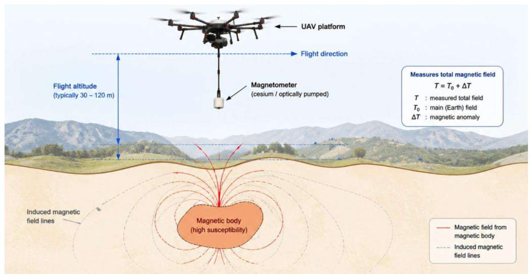
Figure 2.
Schematic illustration of UAV-based electromagnetic survey: (a) Loop source configuration of semi-airborne electromagnetic (SAEM) system with a transmitter loop on the ground. (b) Grounded wire source configuration of semi-airborne electromagnetic (SAEM) system with a grounded-wire transmitter.
Figure 2.
Schematic illustration of UAV-based electromagnetic survey: (a) Loop source configuration of semi-airborne electromagnetic (SAEM) system with a transmitter loop on the ground. (b) Grounded wire source configuration of semi-airborne electromagnetic (SAEM) system with a grounded-wire transmitter.
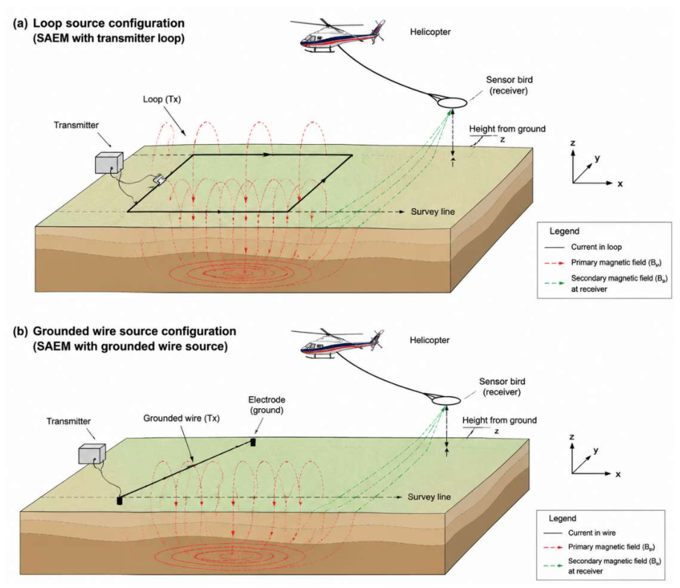
Figure 3.
Schematic illustration of UAV-based ground-penetrating radar (GPR) survey for glacier exploration.
Figure 3.
Schematic illustration of UAV-based ground-penetrating radar (GPR) survey for glacier exploration.
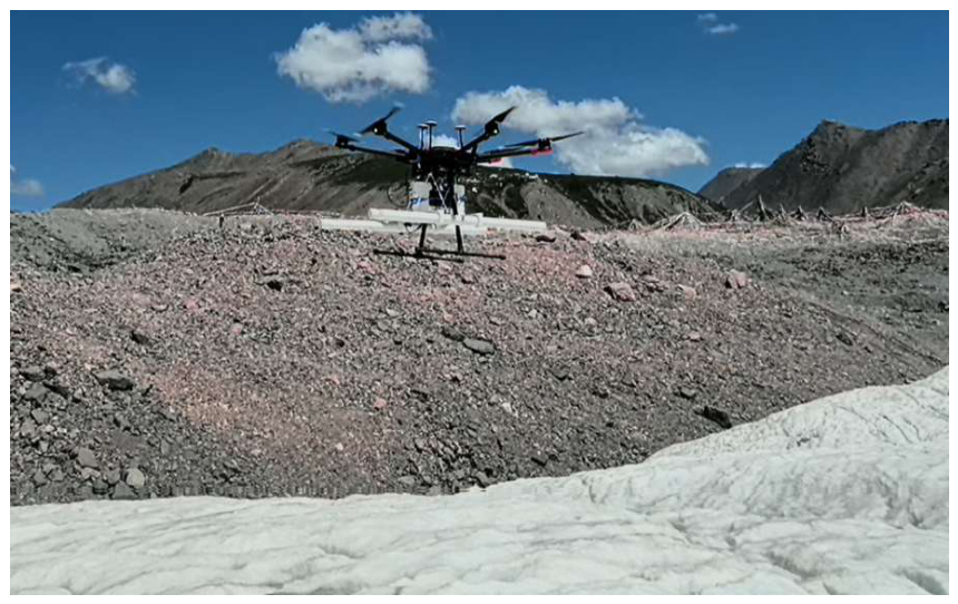
Figure 4.
UAV-based seismic source system.
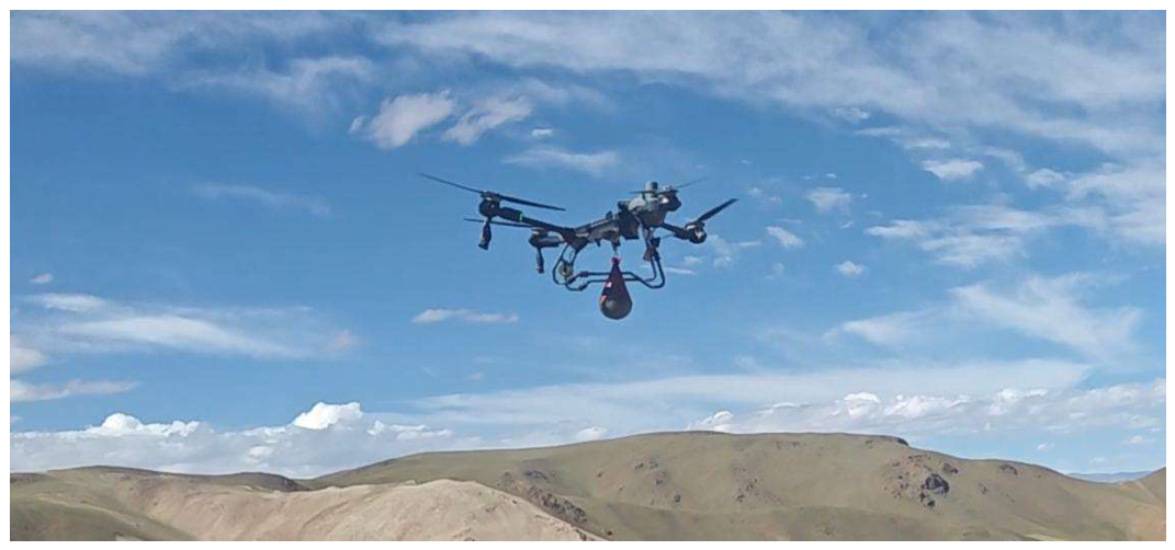
Disclaimer/Publisher’s Note: The statements, opinions and data contained in all publications are solely those of the individual author(s) and contributor(s) and not of MDPI and/or the editor(s). MDPI and/or the editor(s) disclaim responsibility for any injury to people or property resulting from any ideas, methods, instructions or products referred to in the content. |
© 2026 by the authors. Licensee MDPI, Basel, Switzerland. This article is an open access article distributed under the terms and conditions of the Creative Commons Attribution (CC BY) license (http://creativecommons.org/licenses/by/4.0/).
Copyright: This open access article is published under a Creative Commons CC BY 4.0 license, which permit the free download, distribution, and reuse, provided that the author and preprint are cited in any reuse.