

Submitted:
03 August 2026
Posted:
04 August 2026
You are already at the latest version
Abstract
Landslides triggered by heavy rainfall have become increasingly frequent and severe, creating a need for the rapid and accurate detection of damaged areas for post-disaster response and recovery planning. This study developed a ChangeFormer-based landslide damage detection model using single-channel differenced Normalized Difference Vegetation Index (dNDVI) imagery derived from pre- and post-event Sentinel-2 data. Landslide reference data were used to construct a patch-based training dataset, and model generalization was evaluated in Sancheong-gun and Hapcheon-gun, Gyeongsangnam-do, Republic of Korea, where landslide damage was reported following heavy rainfall in 2025. As available reference data differed between these regions, region-specific validation strategies were applied. In Sancheong-gun, polygon and point reference data were used for quantitative validation. The model achieved a producer’s accuracy of 100% in the polygon-based validation, detecting all 12 reference damaged sites, and point-based validation showed increasing accuracy with buffer radius, reaching 87.9% accuracy at 80–100 m. In Hapcheon-gun, where quantitative reference data were unavailable, qualitative assessment based on drone imagery indicated that the detected areas were generally consistent with locations believed to represent actual landslide damage. These results suggest that the proposed framework is effective for the post-disaster spatial assessment of landslide-damaged areas.
Keywords:
landslide damage detection
; change detection
; remote sensing
; satellite imagery
1. Introduction
Climate change-associated changes in rainfall patterns and increasing occurrences of localized extreme rainfall events have been closely associated with a growing frequency of landslides with increasing scales of damage worldwide [1,2]. In the Republic of Korea, where mountainous areas account for more than 60% of the national territory, landslides tend to occur during periods of heavy summer rainfall and typhoons, and the extent of damage has recently increased [3]. After such events, the rapid and accurate identification of the location and extent of landslide-damaged areas provides essential baseline information for decision-making throughout the disaster response process, including the designation of restoration sites, prioritization of recovery, prevention of secondary damage, and estimation of restoration costs [4,5,6]. Accordingly, a demand for technologies capable of detecting landslide-damaged areas using satellite imagery and remote sensing data has steadily increased [1,7,8,9,10,11,12,13,14].
In early landslide damage detection research, landslide damaged-area boundaries were primarily extracted using spectral indices, such as the normalized difference vegetation index (NDVI) and dNDVI [15,16]. Although spectral index-based approaches are computationally efficient and applicable to large areas, they are sensitive to certain environmental factors in satellite imagery, including exposed soil, shadows, and seasonal vegetation variation, which may cause non-landslide areas to be misidentified as damaged areas [17,18,19,20]. Subsequently, conventional machine learning methods, such as the random forest and support vector machine algorithms, were introduced to improve detection performance by combining spectral information with topographic variables [21,22]. However, such approaches are sensitive to input feature composition and training data quality, and their generalizability across regions and time periods may be limited because of spatial and temporal biases in the training data [23,24]. In addition, pixel-based classification results may produce unrealistic spatially fragmented patterns, affecting the continuity of landslide-damaged-area boundary delineation [25]. To address these limitations, convolutional neural network (CNN)-based image segmentation techniques have been applied to the extraction of landslide damaged-area boundaries, with improved performances reported, particularly when using U-Net-based models [26,27,28,29]. Nevertheless, although CNN-based models are effective at learning local features among neighboring pixels, their ability to recognize structural patterns over broad spatial extents in satellite imagery, such as landslide damage continuously distributed across a slope, remains limited [30,31,32,33,34].
More recently, transformer architectures based on the self-attention mechanism have been introduced, allowing the relationships among all pixels within an image to be considered simultaneously [35,36]. Transformer-based models can learn long-range spatial dependencies and relationships in a structured manner, making them suitable for representing change patterns distributed over wide areas [37,38,39,40,41]. The ChangeFormer family of models is specifically designed to progressively extract and integrate differences between pre- and post-event imagery, enabling the joint learning of both the location of changed areas and their spatial continuity [42,43,44].
This study developed a ChangeFormer-based landslide damage detection model using single-channel dNDVI imagery as the input to detect vegetation changes during rainfall events. However, as the type of accuracy required may differ according to the purpose of use, and the applicability of a model cannot be sufficiently explained using only a single reference type, the performance of a landslide damage detection model should be interpreted in relation to its intended application. For decision-making tasks like the selection of restoration target sites and the estimation of restoration workloads, the accurate representation of damaged-area extent and landslide damaged-area boundaries is important. In contrast, for field investigation, emergency dispatch, and priority setting, the detections to actual landslide locations may be more important. In addition, because the forms of officially available reference data differ across regions, evaluating model performance using only a single criterion may limit its real-world applicability. Therefore, in this study, the developed model’s generalization performance was validated using damaged areas not included in model training. Furthermore, by combining quantitative and qualitative validation according to the type and availability of reference data, this study aimed to evaluate both the spatial detection performance and the field applicability of the proposed model.
2. Materials and Methods
2.1. Study Area
Two study areas, one in Sancheong-gun and one in Hapcheon-gun in Gyeongsangnam-do, Republic of Korea, where landslide damage was reported following heavy rainfall in 2025, were selected to evaluate the applicability of the developed landslide damage detection model. Both areas were independent from the model training dataset and were used as validation sites to assess model performance for newly reported landslide damage cases.
In Sancheong-gun, both polygon-type and point-type official reference data were available for the landslide damage reported in 2025 (Figure 1). The National Institute of Forest Science (NIFoS) reference data provided landslide damaged-area boundaries as polygons, whereas the Korea Forest Service (KFS) reference data provide landslide occurrence locations as points. Accordingly, both area-based and location-based quantitative validation were conducted in Sancheong-gun.
Although landslide damage was reported in Hapcheon-gun in 2025 (Figure 2), officially accessible reference data enabling spatially quantitative validation, such as landslide damaged-area boundary polygons or occurrence-location points, were limited. Therefore, the spatial validity of model detection results in Hapcheon-gun was qualitatively assessed through visual interpretation of drone imagery.
2.2. Training Data Construction and Data Processing
2.2.1. Training Data for Landslide-Damaged Areas
To construct the training data for the landslide damage detection model, this study used landslide reference data provided by the Korea Association of Forest Enviro-Conservation Technology (KAFET). These data consist of nationwide spatial information on landslide damage cases across multiple years, with landslide damaged-area boundaries as polygons. Prior to model training, a visual interpretation and quality review of the reference data were performed, and cases with relatively clear landslide damaged-area boundaries and sufficient comparability with satellite image-based detection results were selected for use in the analysis (Figure 3). This procedure was intended to minimize the effects of positional error or boundary uncertainty on model training. The final reference dataset was then used as the baseline dataset for input satellite image selection and overall data processing.
2.2.2. Satellite Imagery and Vegetation Indices
To accommodate this spatial and temporal variability in the KAFET landslide reference dataset, Sentinel-2 Level-2A (L2A) imagery was used as the input in this study. Sentinel-2 provides multispectral bands at a 10 m spatial resolution, with a revisit cycle of approximately 5 days, making it suitable for analyzing vegetation changes before and after landslide events.
Pre- and post-damage images were selected based on the estimated occurrence period of each landslide case. Images taken within one month before the period’s start date were defined as pre-damage images, and images taken within one month after the period’s end date were defined as post-damage images. Sentinel-2 imagery was acquired through the Copernicus Open Access Hub API, and scenes with less than 10% cloud cover were preferentially used to minimize cloud-related effects.
Landslide damage is generally accompanied by slope failure and soil runoff, resulting in the abrupt destruction of existing vegetation. To quantitatively capture this change, the NDVI was calculated, and the dNDVI, the difference between the NDVI values from the pre- and post-damage images, was used as the main input variable. Unlike the NDVI, which describes vegetation conditions at a single time point, the dNDVI directly represents the magnitude of change in vegetation during the event, making it suitable for identifying vegetation disturbance caused by landslides. The dNDVI was used as the input variable for the change detection-based landslide damage detection model in this study.
2.3. Development of the Landslide Damage Detection Model
2.3.1. Training and Validation Dataset Construction
The KAFET landslide reference polygons and corresponding Sentinel-2 dNDVI images were aligned to the same coordinate system and then organized into a patch-based training dataset. Patch sizes were set to 128 × 128 pixels, approximately 1.28 km × 1.28 km, given the 10 m spatial resolution of Sentinel-2 imagery. This size represented a spatial unit capable of including both landslide-damaged areas and adjacent slope environments within a single patch.
Up to three patches were extracted, with reference to the central part of each polygon, for each landslide-damaged-area boundary polygon. All patches were constructed so that the dNDVI imagery and damage mask shared the same spatial location, minimizing spatial mismatch between input and ground truth data.
As some images contained a low proportion of landslide-damaged pixels, only patches containing at least 200 damaged pixels were used as training samples. Additionally, the number of undamaged-area patches was limited to a maximum of twice that of damaged-area patches to control class balance in the training dataset. To reduce data imbalance, damaged-area patches were duplicated three times in the training data. The entire dataset was split into training and validation subsets at a ratio of 80% to 20% for use in change detection model training.
2.3.2. Model Configuration
In this study, landslide damage detection was approached as a matter of detecting changes between pre- and post-event conditions, and a transformer-based change detection model was applied to this problem. The model consisted of a ChangeFormer family encoder–decoder architecture and was designed to learn overall change patterns and long-range spatial dependencies through the self-attention mechanism.
The single-channel dNDVI imagery derived from pre- and post-damage Sentinel-2 scenes was used as the model input. The input images were divided into 128 × 128 pixel patches, each preserving the pre- and post-event change information from the corresponding spatial location, which were fed into the model. This allowed the model to learn through event-induced changes rather than absolute vegetation conditions.
The encoder of the ChangeFormer model consisted of multi-stage transformer blocks, in which the change information in the dNDVI imagery is progressively abstracted. In the decoder, multi-scale features transferred from the encoder are integrated to reconstruct segmentation results for landslide-damaged areas at the original image resolution. During this process, the self-attention operation captures not only pixel-level changes but also spatial change patterns appearing continuously at the slope scale.
Model training was conducted in a Python-based PyTorch environment. Considering the sparsity of landslide-damaged pixels in the patches, a combination of loss functions emphasizing recall was applied during training, and both data augmentation and early stopping were applied to control overfitting. After training, the completed model was applied independently to the two validation study sites in Gyeongsangnam-do to evaluate landslide damage detection performance.
2.4. Accuracy Assessment
Because the forms of reference data available for landslide damage differed between the Sancheong-gun and Hapcheon-gun study areas, using a single validation criterion for both areas would be difficult, and region-specific validation methods were applied.
For the Sancheong-gun area, where both the NIFoS polygon (Figure 4) and KFS point (Figure 5) datasets were available, location detection performance was evaluated by jointly applying quantitative validation based on spatial overlap between the detection results and the reference polygons and buffer-based quantitative validation based on the points. For the polygon data, the omission of damaged areas was assessed by calculating the proportion of actual damaged sites that were detected. For the point data, buffer zones with radii increasing from 10 to 100 m at 10 m intervals were established around each occurrence point, and the spatial proximity of the nearest detected damaged areas was evaluated for each buffer zone based on whether detection results were included (Figure 6).
As the availability of official reference data enabling quantitative validation, such as polygon or point datasets, was limited for the Hapcheon-gun sites, instead of calculating quantitative accuracy metrics, the spatial validity of the detection results was examined through visual interpretation based on drone imagery. The drone imagery was acquired around locations where landslide damage had been reported, and the spatial overlap between the detection results and areas suspected to represent actual landslide damage in the imagery was assessed.
3. Results
3.1. Data Processing Results
Analysis of the dataset constructed from the KAFET landslide reference data and Sentinel-2 imagery showed that there were clear differences in the distributions of dNDVI values between landslide-damaged and undamaged areas. In undamaged areas, dNDVI values tended to be distributed around zero, indicating limited change between pre- and post-event conditions. By contrast, damaged areas showed relatively higher frequencies in ranges below zero. Thus, dNDVI values decreased more in damaged areas than in undamaged areas, suggesting that the disturbance to vegetation caused by landslides was reflected in the magnitude of change in the NDVI. This, in turn, indicates that a change-based approach is more suitable for landslide damage detection than an approach relying solely on vegetation status at a single time point. Accordingly, the dNDVI was used as the input variable for the change detection-based model in this study.
3.2. Results of Landslide Damage Detection Model Development
The ChangeFormer-based change detection model was trained for a total of 50 epochs. During training, the loss value was 0.5886 at epoch 1, decreased to 0.4953 at epoch 2 and to 0.4756 at epoch 3, and then remained at approximately 0.48 from epoch 4 until the end of training. Thus, after the initial rapid decrease, the loss value stabilized, indicating that dNDVI-based change patterns were consistently captured during the training process. No abrupt fluctuations in the loss value were observed, and convergence was maintained throughout the process. Furthermore, analyzing the training logs for the internal validation data showed that recall-based performance metrics were maintained without sharp deterioration throughout training. This suggests that the training data design and loss function settings, which were configured considering the sparsity of landslide-damaged pixels, contributed to training stability.
3.3. Model Accuracy
3.3.1. Accuracy for the Sancheong-Gun Area
In Sancheong-gun, quantitative validation was performed using NIFoS reference data, which provide landslide damaged-area boundaries as polygons, and KFS reference data, which provide landslide occurrence locations as points. First, the producer’s accuracy was calculated for the Buri and Mogori areas using the polygon data. A total of 12 landslide-damaged sites were identified for these areas in the NIFoS reference data, and all 12 sites were detected by the model, resulting in a producer’s accuracy of 100% (Table 1). For validation using the point data, buffer zones increasing in radius from 10 to 100 m at 10 m intervals were established around each occurrence point, and accuracy was calculated based on whether detection results were included within each buffer range.
The KFS reference dataset consisted of 33 points in total. In the 40–50 m buffer range, 25 of the 33 points were included in the detection results, corresponding to an accuracy of approximately 76%. Accuracy increased to approximately 85% at 60–70 m and to approximately 88% at 80–100 m (Table 2). Thus, a stepwise increase in detection accuracy was observed as the buffer distance increased. For several sites that exhibited spatial mismatch between the NIFoS and KFS reference data, additional visual interpretation based on Sentinel-2 imagery was conducted. Most of these locations exhibited land-cover characteristics suggesting landslide damage, although they were not included in the NIFoS polygon reference data.
3.3.2. Accuracy for the Hapcheon-Gun Area
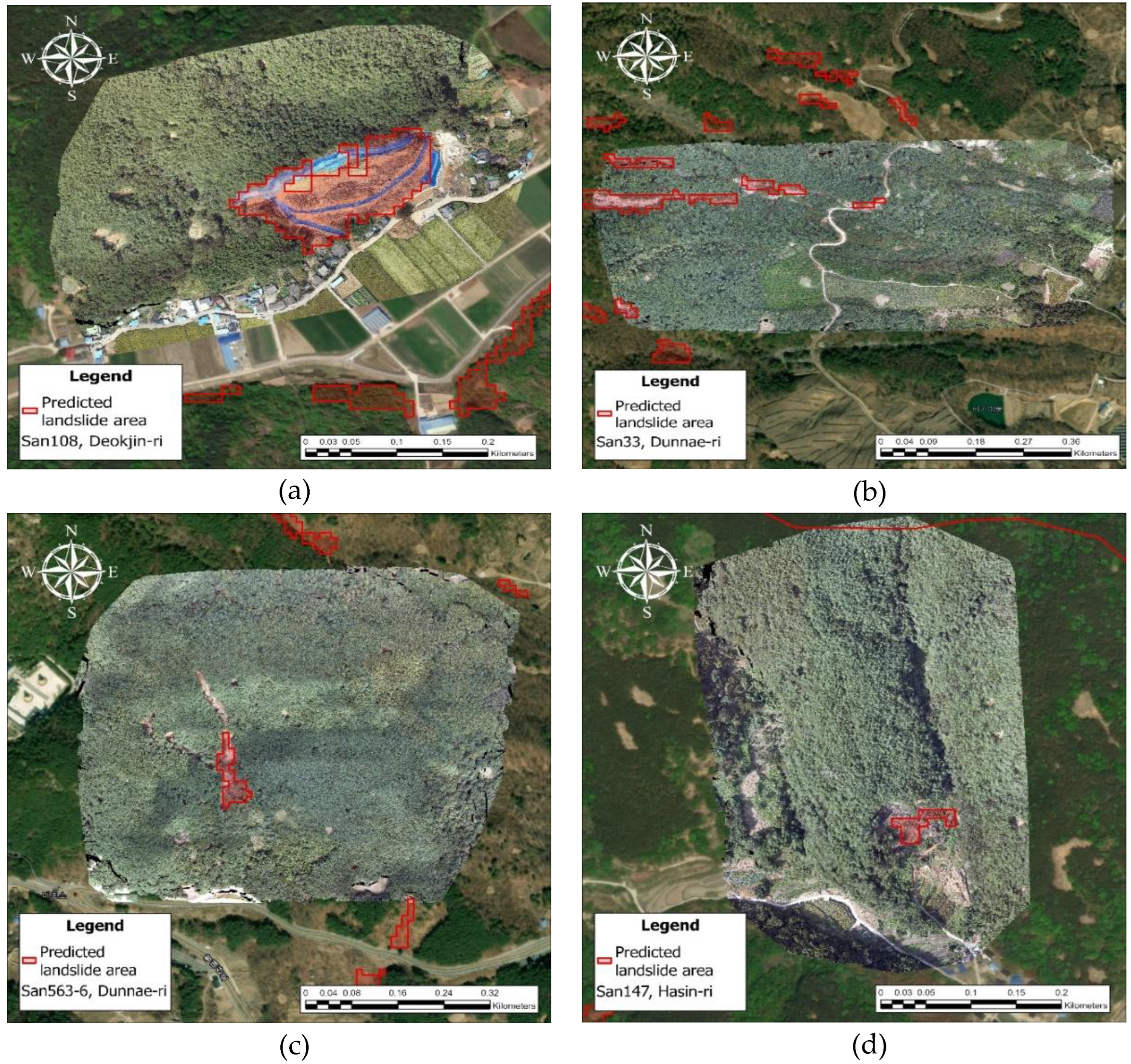
In Hapcheon-gun, official polygon and point reference data were not available. Therefore, instead of calculating accuracy quantitatively, the spatial validity of the detection results was examined by visually interpreting drone imagery. The drone imagery was acquired around sites where major landslide damage had been reported, and comparisons were made between the model detection results and the actual damage locations, slope-failure directions, and distributions of soil runoff zones. In the areas of Hasin-ri San 147, Deokjin-ri San 108, Dunnae-ri San 33, and Dunnae-ri San 563-6, detection results were distributed around zones showing substantial vegetation change during the event and showed patterns similar to the central locations and development directions of the damaged areas identified in the drone imagery (Figure 7). However, in some locations where the scale of damage was relatively small or the terrain was complex, the detected damaged-area boundary appeared to be an underestimate. In these cases, parts of the upper-slope area were found to have been excluded from the detection results during the slope-based filtering process.
4. Discussion
During training of the dNDVI-based change detection model, loss values decreased in the early epochs and then remained relatively stable. This learning pattern indicates that the change features included in the training data were consistently captured during model learning and suggests that the patch-based dataset design and positive-patch duplication strategy, both developed to compensate for the sparsity of landslide-damaged pixels, contributed to training stability.
In Sancheong-gun, producer’s accuracy, based on the overlap of predicted and reference polygons, reached 100%, indicating that all reference-defined damaged sites were detected. In the accuracy assessment using point data with buffer zones, detection accuracy increased stepwise as the buffer radius increased, suggesting that the model detected landslide-damaged areas with reasonably appropriate spatial proximity. In Hapcheon-gun, since official quantitative reference data were unavailable, visual interpretation based on drone imagery was performed. Many cases showed relatively good agreement between the detection results and the actual damage areas and slope-failure directions, although improvement may still be needed in sites where the scale of damage is small or the terrain is complex.
Overall, the change detection-based approach applied in this study appears capable of achieving a relatively high level of spatial accuracy in landslide damage detection. However, because detection results may vary with image acquisition timing, cloud effects, and topographic conditions, these factors should be considered when interpreting results.
5. Conclusions
This study approached landslide damage detection not as a single-date image segmentation problem, but as a change detection problem by estimating land-surface changes occurring during rainfall events and developing a transformer-based change detection model using the dNDVI as input. The training dataset was constructed using nationwide reference data on landslide-damaged areas, and independent validation datasets were conducted using newly reported landslide cases from 2025.
The proposed approach detected the major occurrence zones of landslide-damaged areas with accuracy similar to that seen in earlier studies using CNN-based U-Net family models. Notably, the 100% producer’s accuracy obtained for the Sancheong-gun validation area using reference polygons may be regarded as an improvement over the omission problems reported in previous image segmentation-based landslide damage detection studies. This improvement can be interpreted as a result of the patch construction strategy and loss function design, which was intended to minimize damaged site omission. While many previous studies relied on single-date inputs, combining multispectral bands or topographic variables, the present study was able to detect continuous distributions of damaged areas at the slope scale relatively stably, even when only the dNDVI, a single-channel input, was used. These findings suggest that an input configuration focused on the magnitude of changes between pre- and post-event images, rather than absolute spectral values, used with a self-attention-based architecture capable of learning long-range spatial dependencies, can be effective for landslide damage detection. In addition, the buffer analysis using reference points showed a stepwise increase in detection accuracy as the buffer radius increased, indicating that the predicted damage areas tended to be spatially distributed around actual damage occurrence locations. However, as observed in Hapcheon-gun, the damaged area was underpredicted in areas with relatively small-scale damage or complex terrain. This suggests that the sensitivity of change detection-based approaches may decrease when the magnitude of dNDVI is relatively small and that post-processing conditions, such as slope filtering, may directly affect detection results. These observations are consistent with model limitations repeatedly noted in previous studies.
To address the limitations of the single-index dNDVI approach, future research should first consider incorporating additional spectral indices sensitive to exposed soil or Synthetic Aperture Radar (SAR)-based change information. Second, to improve detection performance for small-scale landslides, comprehensive sensitivity analyses of patch extraction criteria and positive sample definition thresholds will be required. Third, strategies for applying adaptive, rather than fixed-threshold, post-processing rules for integrating slope and terrain should be examined. Finally, because differences in reference data construction criteria can affect accuracy assessment, the systematic establishment of a multi-reference evaluation framework will be necessary in future studies.
Author Contributions
Conceptualization, G.J., C.W. and J.P.; methodology, G.J. and M.L.; software, G.J.; validation, G.J. and M.L.; formal analysis, G.J., M.L. and B.K.; investigation, G.J. and B.K.; resources, C.W.; data curation, G.J. and C.W.; writing—original draft preparation, G.J.; writing—review and editing, Y.S., Y.K., and J.P.; visualization, G.J.; supervision, C.W., Y.K. and J.P.; project administration, C.W. and J.P.; funding acquisition, C.W. and J.P. All authors have read and agreed to the published version of the manuscript.
Funding
This study was carried out with the support of ‘R&D Program for Forest Science Technology (RS-2025-02213492)’ provided by Korea Forest Service (Korea Forestry Promotion Institute) and ‘NIFoS Project (FM0103-2021-02)’ provided by National Institute of Forest Science.
Conflicts of Interest
The authors declare no conflicts of interest.
Acknowledgments
The authors acknowledge the financial support provided by the R&D Program for Forest Science Technology (RS-2025-02213492) and NIFoS Project (FM0103-2021-02), funded by the Korea Forest Service through the Korea Forestry Promotion Institute and National Institute of Forest Science.
Abbreviations
The following abbreviations are used in this manuscript:
| NDVI | Normalized Difference Vegetation Index |
| dNDVI | differenced NDVI |
| CNN | Convolutional Neural Network |
| U-Net | U-shaped Network |
| NIFoS | National Institute of Forest Science |
| KFS | Korea Forest Service |
| KAFET | Korea Association of Forest Enviro-Conservation Technology |
| API | Application Programming Interface |
| L2A | Level-2A |
| SAR | Synthetic Aperture Radar |
References
- Fang, Z.; Morales, A.B.; Wang, Y.; Lombardo, L. Climate change has increased rainfall-induced landslide damages in central China. Int. J. Disaster Risk Reduct. 2025, 119, 105320. [Google Scholar] [CrossRef]
- Kirschbaum, D.; Kapnick, S.B.; Stanley, T.; Pascale, S. Changes in Extreme Precipitation and Landslides Over High Mountain Asia. Geophys. Res. Lett. 2020, 47, e2019GL085347. [Google Scholar] [CrossRef]
- Kim, J.C.; Lee, S. Comparative Study of Deep Neural Networks for Landslide Susceptibility Assessment: A Case Study of Pyeongchang-gun, South Korea. Sustainability 2024, 16. [Google Scholar] [CrossRef]
- Aman, M.A.; Chu, H.-J.; Yunus, A.P. Exploration of Multi-Decadal Landslide Frequency and Vegetation Recovery Conditions Using Remote-Sensing Big Data. Earth Syst. Environ. 2025, 9, 197–213. [Google Scholar] [CrossRef]
- Lian, X.G.; Li, Y.; Wang, X.B.; Shi, L.F.; Xue, C.H. Research on Identification and Location of Mining Landslide in Mining Area Based on Improved YOLO Algorithm. Drones 2024, 8. [Google Scholar] [CrossRef]
- Adriano, B.; Yokoya, N.; Miura, H.; Matsuoka, M.; Koshimura, S. A Semiautomatic Pixel-Object Method for Detecting Landslides Using Multitemporal ALOS-2 Intensity Images. Remote Sens. 2020, 12. [Google Scholar] [CrossRef]
- Mohan, A.; Singh, A.K.; Kumar, B.; Dwivedi, R. Review on remote sensing methods for landslide detection using machine and deep learning. Trans. Emerg. Telecommun. Technol. 2021, 32, e3998. [Google Scholar] [CrossRef]
- Zhong, C.; Liu, Y.; Gao, P.; Chen, W.; Li, H.; Hou, Y.; Nuremanguli, T.; Ma, H. Landslide mapping with remote sensing: challenges and opportunities. Int. J. Remote Sens. 2020, 41, 1555–1581. [Google Scholar] [CrossRef]
- Aman, M.A.; Chu, H.-J.; Patra, S.R.; Kumar, V. Rapid Mapping of Rainfall-Induced Landslide Using Multi-Temporal Satellite Data. Remote Sens. 2025, 17, 1407. [Google Scholar] [CrossRef]
- Abdollahi, A.; Pradhan, B. Integrating semantic edges and segmentation information for building extraction from aerial images using UNet. Mach. Learn Appl.-Neth. 2021, 6. [Google Scholar] [CrossRef]
- Bardi, F.; Frodella, W.; Ciampalini, A.; Bianchini, S.; Del Ventisette, C.; Gigli, G.; Fanti, R.; Moretti, S.; Basile, G.; Casagli, N. Integration between ground based and satellite SAR data in landslide mapping: The San Fratello case study. Geomorphology 2014, 223, 45–60. [Google Scholar] [CrossRef]
- Dong, J.; Zhang, L.; Tang, M.G.; Liao, M.S.; Xu, Q.; Gong, J.Y.; Ao, M. Mapping landslide surface displacements with time series SAR interferometry by combining persistent and distributed scatterers: A case study of Jiaju landslide in Danba, China. Remote Sens. Env. 2018, 205, 180–198. [Google Scholar] [CrossRef]
- Gao, X.; Lu, P. Dual-encoder multiscale transformer fusion network for landslide detection integrating Sentinel-2 spectral and topographic clues. Landslides 2026. [Google Scholar] [CrossRef]
- Ren, J.; Yang, W.N.; Ma, Z.G.; Li, W.L.; Zeng, S.; Fu, H.; Wen, Y.; He, J.Y. Remote Sensing-Based Detection and Analysis of Slow-Moving Landslides in Aba Prefecture, Southwest China. Remote Sens. 2025, 17. [Google Scholar] [CrossRef]
- Dahigamuwa, T.; Yu, Q.; Gunaratne, M. Feasibility Study of Land Cover Classification Based on Normalized Difference Vegetation Index for Landslide Risk Assessment. Geosciences 2016, 6, 45. [Google Scholar] [CrossRef]
- Lindsay, E.; Frauenfelder, R.; Rüther, D.; Nava, L.; Rubensdotter, L.; Strout, J.; Nordal, S. Multi-Temporal Satellite Image Composites in Google Earth Engine for Improved Landslide Visibility: A Case Study of a Glacial Landscape. Remote Sens. 2022, 14, 2301. [Google Scholar] [CrossRef]
- Esposito, G.; Famiani, D. Application of the BNDVI index as proxy for burn severity assessment. Earth Sci. Inform. 2025, 18, 501. [Google Scholar] [CrossRef]
- Guo, Q.; Tong, L.; Wang, H. A Monitoring Method Based on Vegetation Abnormal Information Applied to the Case of Jizong Shed-Tunnel Landslide. Remote Sens. 2022, 14, 5640. [Google Scholar] [CrossRef]
- Sun, J.; Yuan, G.; Song, L.; Zhang, H. Unmanned Aerial Vehicles (UAVs) in Landslide Investigation and Monitoring: A Review. Drones 2024, 8, 30. [Google Scholar] [CrossRef]
- Wu, S.; Di, B.; Ustin, S.L.; Wong, M.S.; Adhikari, B.R.; Zhang, R.; Luo, M. Dynamic Characteristics of Vegetation Change Based on Reconstructed Heterogenous NDVI in Seismic Regions. Remote Sens. 2023, 15, 299. [Google Scholar] [CrossRef]
- Dias, H.; Sandre, L.; Alarcón, D.; Grohmann, C.; Quintanilha, J. Landslide recognition using SVM, Random Forest, and Maximum Likelihood classifiers on high-resolution satellite images: A case study of Itaóca, southeastern Brazil. Braz. J. Geol. 2021, 51. [Google Scholar] [CrossRef]
- Sharma, A.; Prakash, C.; Manivasagam, V.S. Entropy-Based Hybrid Integration of Random Forest and Support Vector Machine for Landslide Susceptibility Analysis. Geomatics 2021, 1, 399–416. [Google Scholar] [CrossRef]
- Cracknell, M.J.; Reading, A.M. The upside of uncertainty: Identification of lithology contact zones from airborne geophysics and satellite data using Random Forests and Support Vector Machines. Geophysics 2013, 78, WB113–WB126. [Google Scholar] [CrossRef]
- Tehrani, F.S.; Santinelli, G.; Herrera Herrera, M. Multi-Regional landslide detection using combined unsupervised and supervised machine learning. Geomat. Nat. Hazards Risk 2021, 12, 1015–1038. [Google Scholar] [CrossRef]
- Parra, F.; González, J.; Chacón, M.; Marín, M. Modeling and Evaluation of the Susceptibility to Landslide Events Using Machine Learning Algorithms in the Province of Chañaral, Atacama Region, Chile. Sustainability 2023, 15, 16806. [Google Scholar] [CrossRef]
- Bragagnolo, L.; Rezende, L.R.; da Silva, R.V.; Grzybowski, J.M.V. Convolutional neural networks applied to semantic segmentation of landslide scars. CATENA 2021, 201, 105189. [Google Scholar] [CrossRef]
- Kaushal, A.; Gupta, A.K.; Sehgal, V.K. A semantic segmentation framework with UNet-pyramid for landslide prediction using remote sensing data. Sci. Rep. 2024, 14, 30071. [Google Scholar] [CrossRef]
- Tang, M.; He, Y.; Aslam, M.; Akpokodje, E.; Jilani, S.F. Enhanced U-Net++ for Improved Semantic Segmentation in Landslide Detection. Sensors 2025, 25, 2670. [Google Scholar] [CrossRef]
- Pyo, J.; Han, K.J.; Cho, Y.R.; Kim, D.; Jin, D.Y. Generalization of U-Net Semantic Segmentation for Forest Change Detection in South Korea Using Airborne Imagery. Forests 2022, 13. [Google Scholar] [CrossRef]
- Lu, W.; Hu, Y.; Zhang, Z.; Cao, W. A dual-encoder U-Net for landslide detection using Sentinel-2 and DEM data. Landslides 2023, 20. [Google Scholar] [CrossRef]
- Meena, S.R.; Soares, L.P.; Grohmann, C.H.; van Westen, C.; Bhuyan, K.; Singh, R.P.; Floris, M.; Catani, F. Landslide detection in the Himalayas using machine learning algorithms and U-Net. Landslides 2022, 19, 1209–1229. [Google Scholar] [CrossRef]
- Vega, J.; Hidalgo, C. Evaluation of U-Net transfer learning model for semantic segmentation of landslides in the Colombian tropical mountain region. MATEC Web Conf., 2024; 396. [Google Scholar]
- Amankwah, S.O.Y.; Wang, G.; Gnyawali, K.; Hagan, D.F.T.; Sarfo, I.; Zhen, D.; Nooni, I.K.; Ullah, W.; Duan, Z. Landslide detection from bitemporal satellite imagery using attention-based deep neural networks. Landslides 2022, 19, 2459–2471. [Google Scholar] [CrossRef]
- Ji, S.P.; Yu, D.W.; Shen, C.Y.; Li, W.L.; Xu, Q. Landslide detection from an open satellite imagery and digital elevation model dataset using attention boosted convolutional neural networks. Landslides 2020, 17, 1337–1352. [Google Scholar] [CrossRef]
- Khalili, M.A.; Palumbo, S.; Madadi, S.; Bausilio, G.; Voosoghi, B.; Calcaterra, D.; di Martire, D. Enhancing Landslide Prediction Through Advanced Transformer-Based Models: Integrating SAR Imagery and Environmental Data. E-J. Nondestruct. Test. 2024. [Google Scholar] [CrossRef]
- Zhao, W.; Zhang, J.; Cai, J.; Ming, D. Hybrid-SegUFormer: A Hybrid Multi-Scale Network with Self-Distillation for Robust Landslide InSAR Deformation Detection. Remote Sens. 2025, 17, 3514. [Google Scholar] [CrossRef]
- Gao, M.; Chen, F.; Wang, L.; Zhao, H.; Yu, B. Swin Transformer-Based Multiscale Attention Model for Landslide Extraction From Large-Scale Area. IEEE Trans. Geosci. Remote Sens. 2024, 62, 1–14. [Google Scholar] [CrossRef]
- Huang, R.; Chen, T. Landslide Recognition from Multi-Feature Remote Sensing Data Based on Improved Transformers. Remote Sens. 2023, 15, 3340. [Google Scholar] [CrossRef]
- Tang, X.; Tu, Z.; Wang, Y.; Liu, M.; Li, D.; Fan, X. Automatic Detection of Coseismic Landslides Using a New Transformer Method. Remote Sens. 2022, 14, 2884. [Google Scholar] [CrossRef]
- Wu, X.; Ren, X.; Zhai, D.; Wang, X.; Tarif, M. Lights-Transformer: An Efficient Transformer-Based Landslide Detection Model for High-Resolution Remote Sensing Images. Sensors 2025, 25, 3646. [Google Scholar] [CrossRef] [PubMed]
- Yadav, D.P.; Sharma, B.; Singh, S.; Liatsis, P. Hybrid lightweight transformer for efficient landslide change detection in remote sensing imagery. Sci. Rep. 2025, 16, 2111. [Google Scholar] [CrossRef] [PubMed]
- Ailimujiang, G.; Jiaermuhamaiti, Y.; Jumahong, H.; Wang, H.; Zhu, S.; Nurmamaiti, P. A Transformer-Based Network for Change Detection in Remote Sensing Using Multiscale Difference-Enhancement. Comput. Intell. Neurosci. 2022, 2022, 2189176. [Google Scholar] [CrossRef] [PubMed]
- Chen, H.; Qi, Z.; Shi, Z. Remote Sensing Image Change Detection With Transformers. IEEE Trans. Geosci. Remote Sens. 2022, 60, 1–14. [Google Scholar] [CrossRef]
- Noman, M.; Fiaz, M.; Cholakkal, H.; Narayan, S.; Anwer, R.M.; Khan, S.; Khan, F.S. Remote Sensing Change Detection With Transformers Trained From Scratch. IEEE Trans. Geosci. Remote Sens. 2024, 62, 1–14. [Google Scholar] [CrossRef]
Figure 1.
Study area in Sancheong-gun, Gyeongsangnam-do.
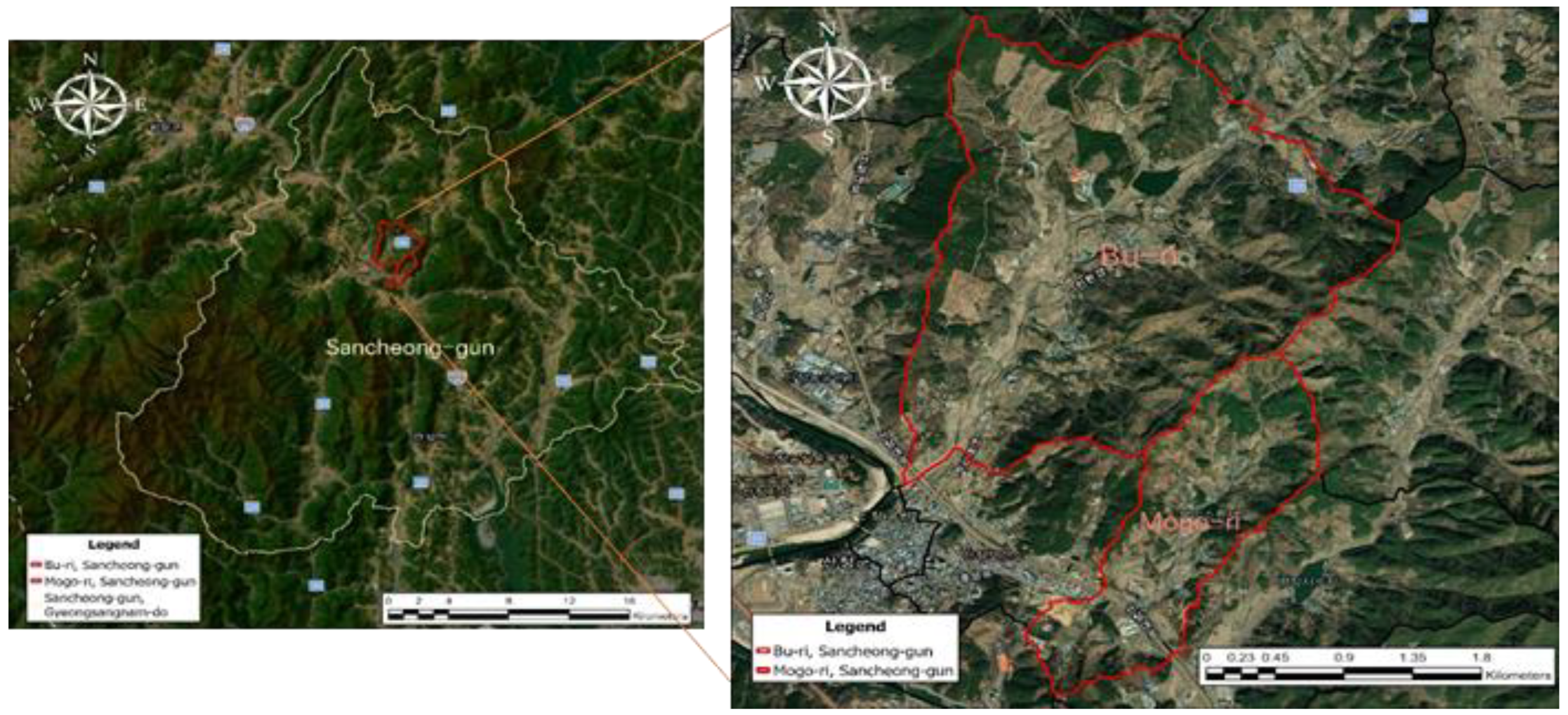
Figure 2.
Study area in Hapcheon-gun, Gyeongsangnam-do.
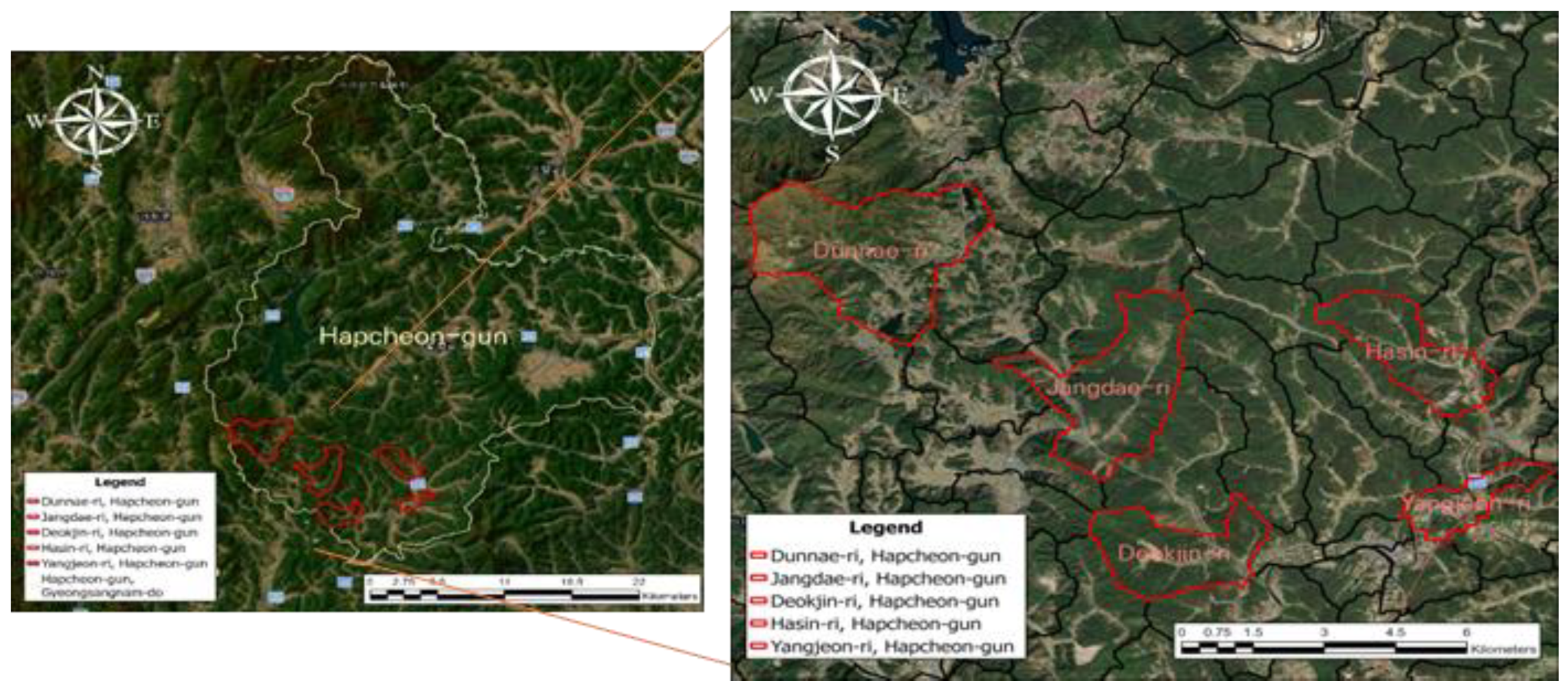
Figure 3.
Example image from the training data provided by the Korea Association of Forest Enviro-conservation Technology (KAFET).
Figure 3.
Example image from the training data provided by the Korea Association of Forest Enviro-conservation Technology (KAFET).
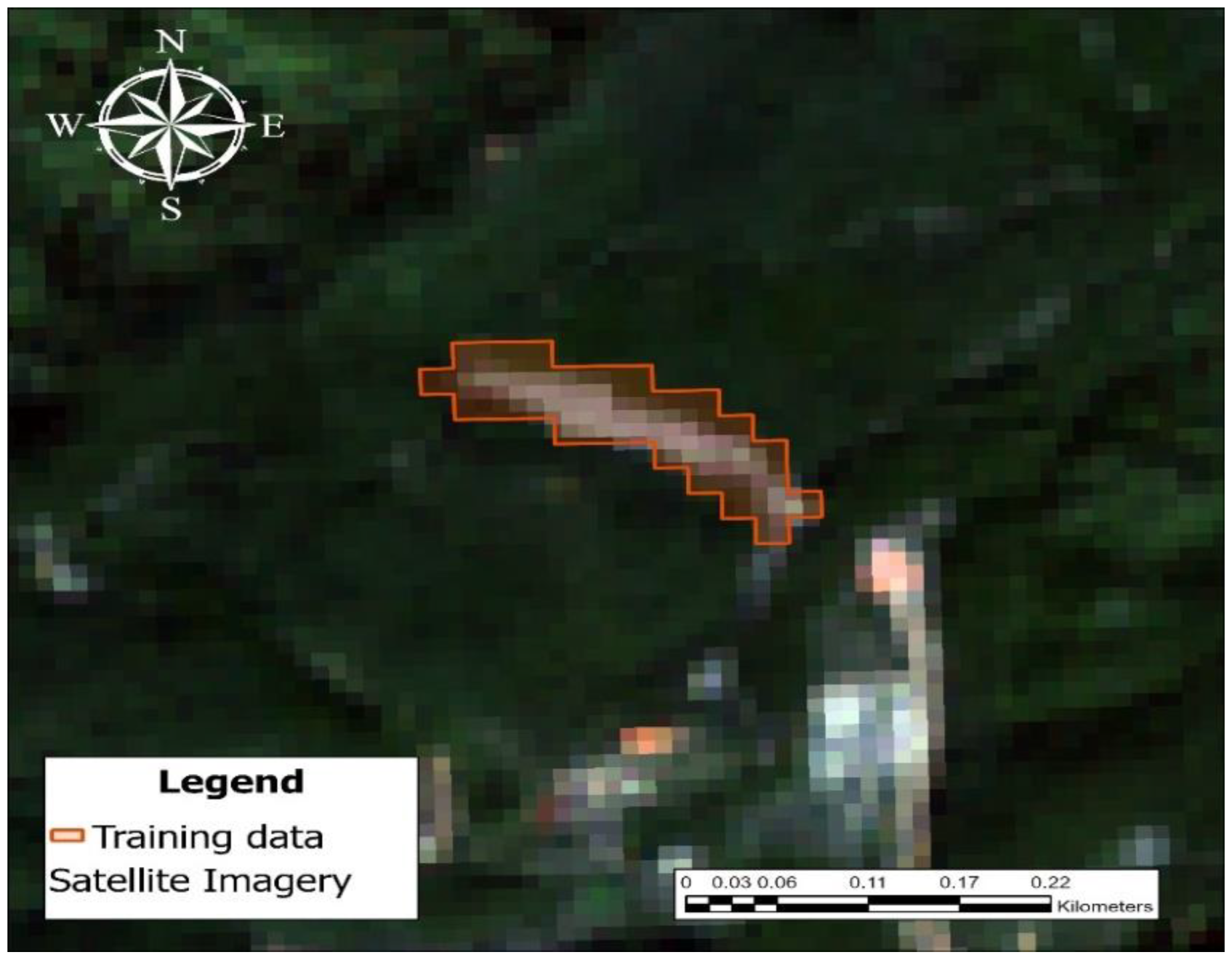
Figure 4.
Landslide reference Polygons provided by NIFoS (National Institute of Forest Science).
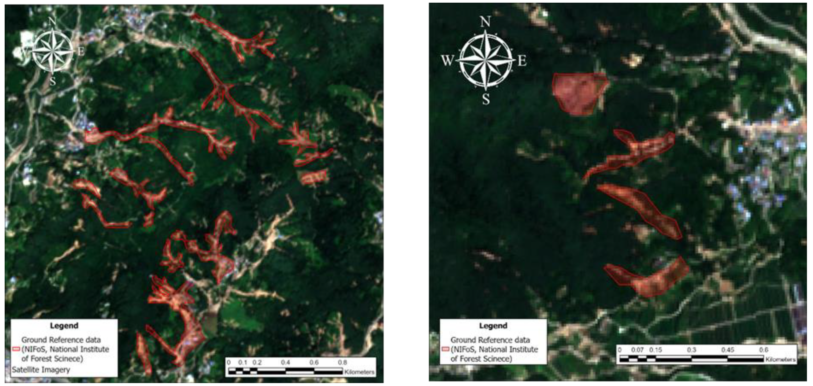
Figure 5.
Landslide reference point data provided by the KFS (Korea Forest Service).
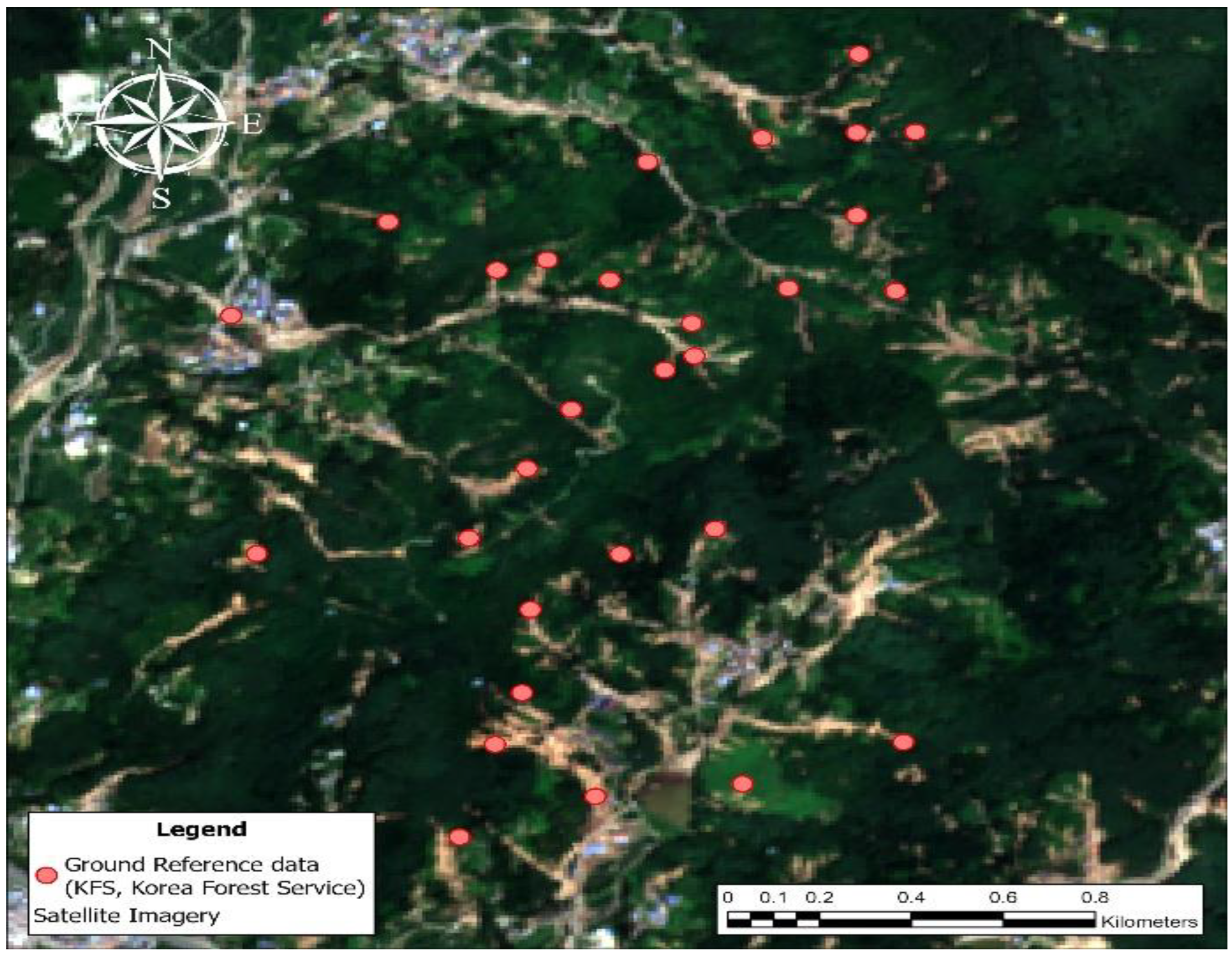
Figure 6.
Example illustrating the buffer-based validation method for accuracy assessment using the point-type landslide reference data provided by KFS.
Figure 6.
Example illustrating the buffer-based validation method for accuracy assessment using the point-type landslide reference data provided by KFS.
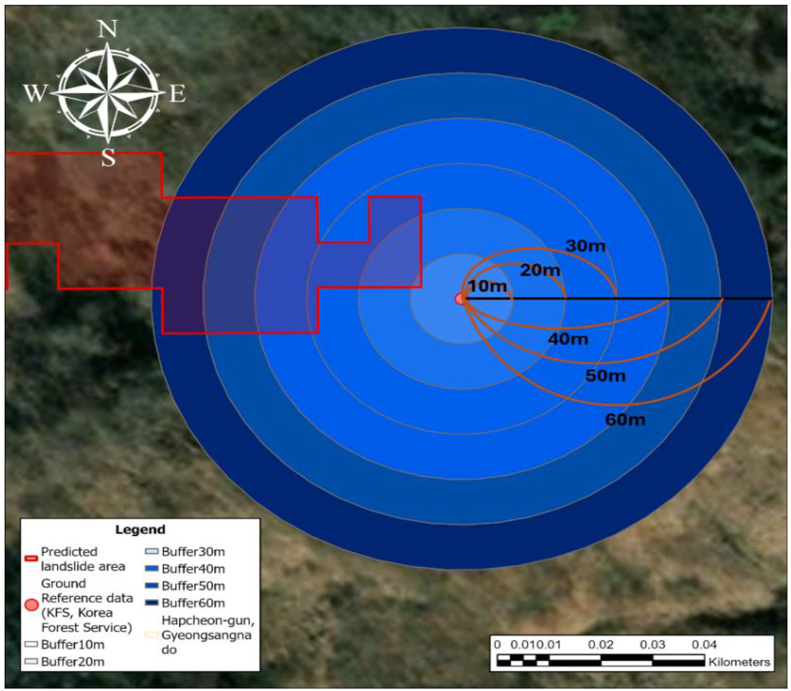
Figure 7.
Results of the landslide detection model for Hapcheon-gun. Predicted landslide polygons are overlaid on drone imagery for (a) San108, Deokjin-ri; (b) San33, Dunnae-ri; (c) San563-6, Dunnae-ri; and (d) San147, Hasin-ri.
Figure 7.
Results of the landslide detection model for Hapcheon-gun. Predicted landslide polygons are overlaid on drone imagery for (a) San108, Deokjin-ri; (b) San33, Dunnae-ri; (c) San563-6, Dunnae-ri; and (d) San147, Hasin-ri.
| Category | Number of Reference Samples | ||||||
| 0–10 m | 10–20 m | 20–30 m | 40–50 m | 60–70 m | 80–100 m | ||
| Predicted Class | Damaged | 12 | 17 | 23 | 25 | 28 | 29 |
| Undamaged | 21 | 16 | 10 | 8 | 5 | 4 | |
| Total | 33 | ||||||
| Accuracy (%) | 36.4 | 51.5 | 69.7 | 75.8 | 84.9 | 87.9 | |
| Category | Number of Reference Samples | |
| Predicted Class | Damaged | 12 |
| Undamaged | - | |
| Total | 12 | |

Table 1.
Prediction results based on reference data from the NIFoS.
| Category | Number of Reference Samples | |
| Predicted Class | Damaged | 12 |
| Undamaged | - | |
| Total | 12 | |
Table 2.
Predicted results according to buffer distance based on reference data from KFS.
| Category | Number of Reference Samples | ||||||
| 0–10 m | 10–20 m | 20–30 m | 40–50 m | 60–70 m | 80–100 m | ||
| Predicted Class | Damaged | 12 | 17 | 23 | 25 | 28 | 29 |
| Undamaged | 21 | 16 | 10 | 8 | 5 | 4 | |
| Total | 33 | ||||||
| Accuracy (%) | 36.4 | 51.5 | 69.7 | 75.8 | 84.9 | 87.9 | |
Disclaimer/Publisher’s Note: The statements, opinions and data contained in all publications are solely those of the individual author(s) and contributor(s) and not of MDPI and/or the editor(s). MDPI and/or the editor(s) disclaim responsibility for any injury to people or property resulting from any ideas, methods, instructions or products referred to in the content. |
© 2026 by the authors. Licensee MDPI, Basel, Switzerland. This article is an open access article distributed under the terms and conditions of the Creative Commons Attribution (CC BY) license (http://creativecommons.org/licenses/by/4.0/).
Copyright: This open access article is published under a Creative Commons CC BY 4.0 license, which permit the free download, distribution, and reuse, provided that the author and preprint are cited in any reuse.