
Submitted:
01 August 2026
Posted:
03 August 2026
You are already at the latest version
Abstract
Urban waterfront spaces that are ecologically sensitive often remain visually prominent yet inaccessible, creating a challenge for environmental management: how to generate public engagement and economic value without physical access. This paper proposes a four-stage socio-ecological framework integrating sensory restoration, behavioral transformation, economic generation, and ecological reinvestment. Using Xianyang Lake in China as a demonstrative case, the study applies six years of phenological records from 36 plant species. Analytic hierarchy process and k-means clustering derive four seasonal sensory palettes ensuring year-round visual, olfactory, and auditory engagement. A WeChat-based guidance system converts passive sensory exposure into active behavioral engagement across walking, bridge viewing, and boating. The framework links enhanced experience to a dynamic revenue model and closes the loop by reinvesting proceeds into maintenance and sediment reuse for greenbelt expansion. The findings shift the paradigm from physical to sensory accessibility, offering a replicable pathway for managing inaccessible urban blue-green spaces.
Keywords:
urban waterfront
; inaccessible space
; sensory experience
; data-driven framework
; circular economy
1. Introduction
Urban waterfront spaces provide ecological regulation, leisure and recreation, and social interaction. As urban renewal shifts from expansion to quality improvement of built-up areas, a new dilemma has emerged: many waterfront spaces have become visible yet inaccessible [1,2]. Ecological sensitivity, flood control requirements, or infrastructure barriers block physical entry. These spaces cannot be activated through conventional interventions like paths or plazas. Yet their landscape value attracts public attention, creating a peculiar form of spatial idleness. The question is how to revitalize such spaces without physical access – a challenge that lies at the intersection of environmental management, landscape protection, and sustainable water resource planning.
Existing research typically assumes that physical accessibility is necessary for spatial value. Kevin Lynch’s imageability and Jan Gehl’s public space theories both presuppose physical presence [3,4]. Recent work on multisensory urbanism has added auditory and olfactory dimensions, but still assumes accessibility [5,6]. For waterfronts closed off for ecological or safety reasons, these frameworks offer limited guidance. Boat tours are often the only way to approach such spaces, but current configurations lack visual diversity, auditory interest, and olfactory stimulation. Visitors have little reason to pay for these experiences. Meanwhile, sustainable maintenance faces other problems: seasonal flooding brings sedimentation, dredging depends on government funding, and sediment is rarely put to productive use [7,8]. Existing waterfront regeneration frameworks assume that physical access is necessary for spatial activation. However, ecologically sensitive or flood-prone waterfronts cannot accommodate physical interventions. No framework has systematically addressed whether sensory experience can substitute for physical access – a question central to environmental management of inaccessible blue-green spaces. While multisensory urbanism has documented the benefits of auditory and olfactory dimensions [5], few studies have linked sensory design to revenue models or ecological reinvestment. The behavioral pathway from sensory exposure - positive affect - willingness to pay remains undertheorized. This gap is particularly relevant for managing urban waterfronts where self-sustaining economic models are needed. Landscape perception research has emphasized plant configuration [9,10], but seasonal phenological data are rarely integrated into management frameworks. Most planting plans remain static, missing the opportunity to create year-round sensory engagement through data-driven design. This gap limits the effectiveness of landscape protection as an environmental management strategy. These gaps point to a core question: without physical access, how can people form emotional connections to a space, and how can that space sustain itself economically and ecologically?
This paper proposes a four-stage socio-ecological framework to address this gap. The framework connects sensory restoration, behavioral guidance, economic returns, and ecological reinvestment. The logic works as follows: multisensory design activates the aesthetic value of an inaccessible space. Differentiated viewing experiences, such as walking, bridge-viewing, and boating, turn passive viewing into active engagement. Revenue from paid activities flows back into maintenance and ecological work. Dredged sediment becomes material for spatial expansion, closing the loop – an application of circular economy principles to urban water management [11]. The framework faces several management-level questions. First, how to select and arrange plants so that an inaccessible space remains attractive across all seasons, engaging vision, smell, and hearing? Landscape perception research emphasizes plant configuration and multisensory integration [9,10]. Second, how to design guidance that moves people from passive viewing to active participation? Environmental psychology suggests that perception alone does not produce action; guiding mechanisms are needed [12,13]. Third, how to link experiential quality to payment in a way that feels natural rather than imposed? Fourth, how to coordinate dredging schedules, sediment reuse, and landscape expansion into a closed material loop?
This paper has three objectives: First, to empirically document how six years of phenological records from 36 plant species can be used to design a year-round sensory landscape in an inaccessible urban waterfront – using Xianyang Lake in China as a demonstrative context. Second, to propose a transferable four-stage socio-ecological framework for managing similar inaccessible spaces without physical entry. Third, to challenge the prevailing assumption that physical accessibility is necessary for spatial value generation, by demonstrating that sensory accessibility can serve as an alternative pathway for environmental management. Together, these objectives integrate sensory design, behavioral guidance, economic mechanisms, and ecological cycling into a closed-loop framework that could sustain itself over time – offering a replicable pathway for managing inaccessible urban blue-green spaces globally.
2. Dilemma of Inaccessible Urban Waterfront Spaces
Inaccessible urban waterfront spaces share a common set of characteristics regardless of their specific location. First, they are visually prominent. Their open water and shoreline configurations make them highly visible from surrounding areas, creating strong landscape presence. Second, they are physically inaccessible. Water bodies, ecological sensitivity, or safety regulations block direct entry. Third, existing viewing modes are limited. Visitors can only observe from a distance with little sensory variety, such as walkways, bridges, or opposite shores. Fourth, boat tours, where available, offer monotonous open-water experiences with minimal engagement with shoreline vegetation. Tourist enthusiasm for such tours is consequently low. These four characteristics define the typical problem context that this framework addresses.
Xianyang Lake’s central greenbelt exhibits all of these characteristics: the open strip-like landscape coupled with physical inaccessibility, the uniformity of existing viewing modes, and the low utilization rate of boat tours [14]. As shown in Figure 1, the central greenbelt (B) has a linear, strip-like configuration that is visually prominent from the north walkway (A) and the covered bridge (C). The water barrier blocks physical access. Current viewing from A and C offers only monotonous water views with no sensory diversity. Boat tours on the lake pass through open water with no engaging shoreline features, resulting in low tourist enthusiasm. This combination of visual prominence, physical inaccessibility, and limited sensory engagement represents a specific type of environmental management challenge: how to generate public value from a space that cannot be physically entered. Using Xianyang Lake as a concrete example, the following sections show how the framework’s four stages, which are sensory restoration, behavioral transformation, economic generation, and ecological reinvestment, can be applied to transform such an inaccessible space into a self-sustaining system.
3. Results
3.1. Sensory Experience Restoration of the Xianyang Lake’s Central Greenbelt
Based on phenological records from 2020 to 2025, 36 plant species were selected for their potential to restore the sensory experience of Xianyang Lake’s Central Greenbelt. To move beyond a purely visual landscape, we employed an analytic hierarchy process (AHP) as a multi-criteria environmental management tool to prioritize four sensory and ecological criteria: visual ornamentation (flower color and form, weight 2.5), landscape color diversity (seasonal chromatic variation, 2.5), multisensory engagement (fragrance and texture, 2.0), and ecological functionality (3.0). Within the last criterion, bird-attracting capacity received the highest sub-weight, as bird songs and movements introduce a dynamic auditory layer to the visitor experience. The weighting scheme passed the consistency test (CR < 0.1), confirming its suitability for guiding sensory-driven environmental management.

Table 1.
Plant Configuration Design for the Central Greenbelt of Xianyang Lake.
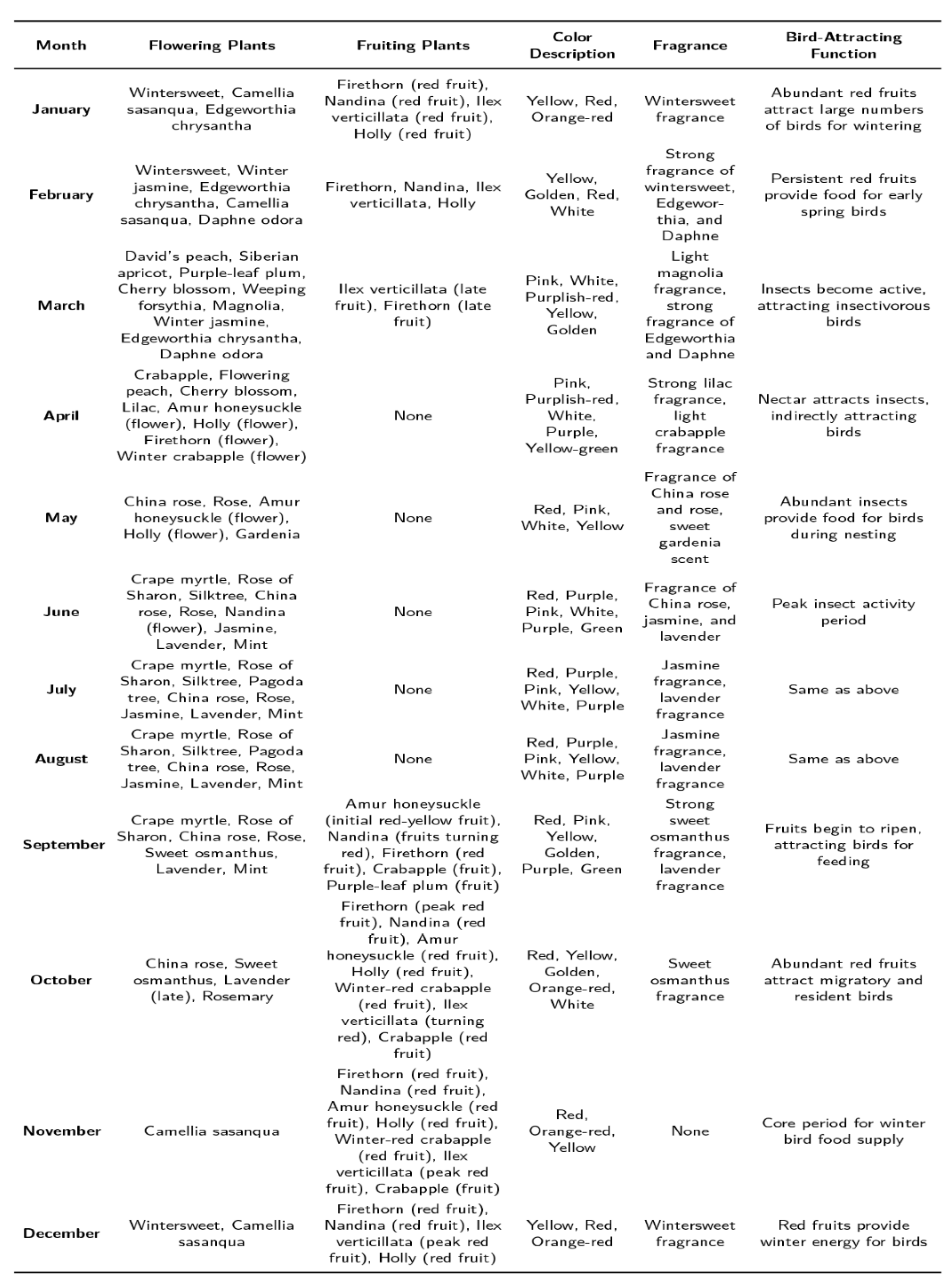 |
Figure 2 presents a radial sector graph visualizing the multidimensional phenological data of the 36 selected species across 12 months. The graph integrates four sensory dimensions: flowering (visual), fruiting (visual), scent timing (olfactory), and bird visitation (auditory). Each species is represented as a radial axis, with concentric rings indicating months. Flowering periods are shown in pink, fruiting in orange. Scent emission is marked with dotted lines: thicker lines denote stronger fragrance intensity. For example, Osmanthus fragrans shows thick dotted lines in September and October (olfactory peak in autumn), while Gardenia jasminoides shows thick lines from June to August (olfactory peak in summer). Bird visitation, indicated by bird icons, is highest in June (12 species), creating a summer auditory peak; a secondary peak occurs in September–October (8 species), linking autumn fruiting with bird activity. The graph reveals that integrated sensory richness peaks in June, remains high from April through August, and experiences a second, fragrance-and-audio-driven peak in autumn — transforming the greenbelt from a visually dominant space into a year-round, multi-layered sensory environment.
To translate this multidimensional phenological data into actionable management interventions for sensory Restoration, we applied k-means clustering. The algorithm processed monthly color and phenological data from all 36 species, characterizing each by dominant flower/fruit color, seasonal timing, and color intensity. The silhouette coefficient method determined the optimal number of clusters (k=4, average silhouette width 0.67), corresponding to the four natural seasons. These clusters form the basis of four distinct sensory palettes, each designed to evoke a different experiential quality. Table 2 presents the resulting seasonal clusters, including dominant color tone, representative species, and transition species that ensure sensory continuity between seasons.
Table 2.
Seasonal plant configuration derived from k means clustering.
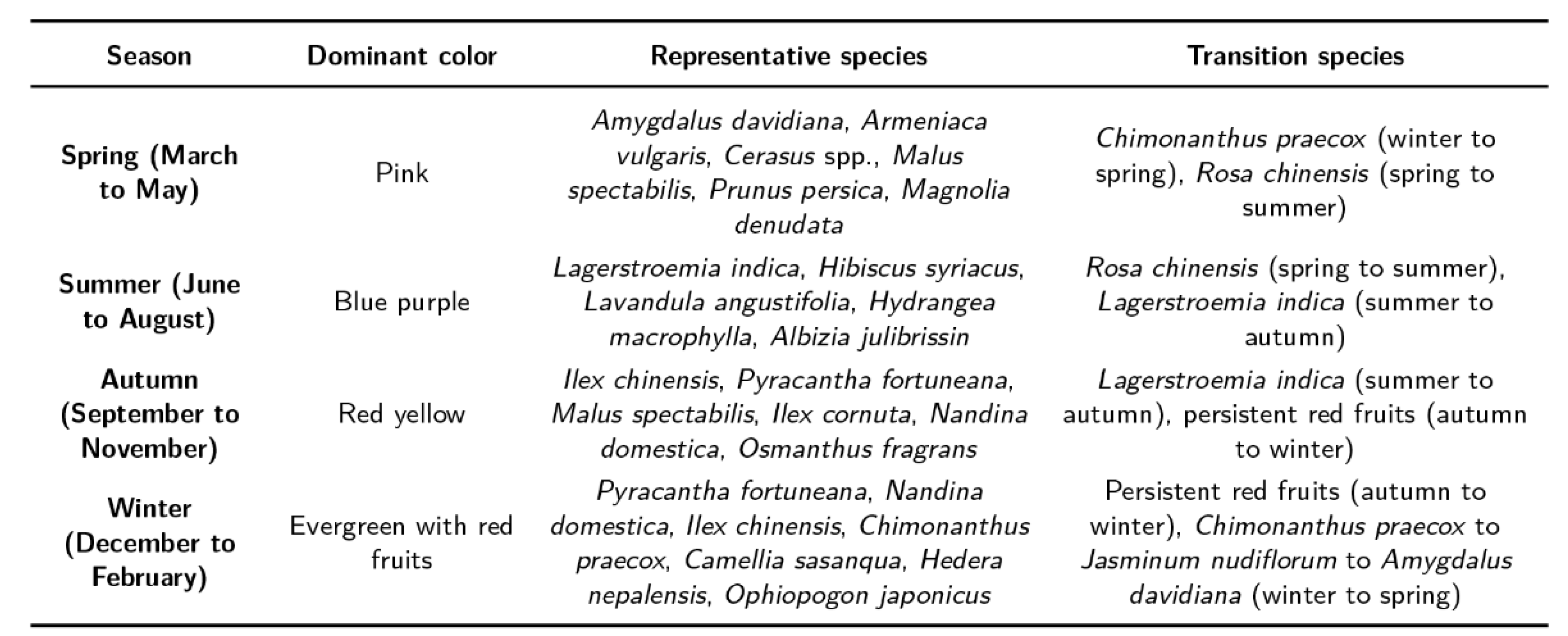 |
Between the four seasonal sensory palettes, white-flowered plants, such as Gardenia jasminoides, Jasminum sambac, and Magnolia denudate, serve as sensory anchors. White is selected for three reasons. First, as an achromatic color, it harmonizes with any chromatic scheme without visual conflict. Second, white flowers are visually salient and draw attention without overwhelming adjacent colors. Third, and most importantly for sensory Restoration, white appears across multiple seasons: Magnolia denudata in early spring (visual + light fragrance), Gardenia jasminoides and Jasminum sambac in summer (strong olfactory presence). This recurring presence stabilizes the overall sensory narrative, offering visitors familiar reference points throughout the year.
Seasonal transitions follow natural phenological sequences to avoid abrupt sensory discontinuities, a key requirement for Restoration the visitor experience into a smooth, year-round journey. Rosa chinensis bridges spring pink and summer blue-purple through continuous blooming from May to October, maintaining visual and olfactory interest. Lagerstroemia indica extends its purplish-red flowers into September, visually anticipating autumn’s red fruits and preventing a sensory gap between summer and autumn. The red fruits of Pyracantha fortuneana, Nandina domestica, and Ilex chinensis persist from September through February, spanning autumn and winter providing both visual color and bird-attracting sounds during the otherwise quieter colder months. Finally, a continuous flowering sequence transitions from winter yellow to spring pink: Chimonanthus praecox (yellow, December–February, fragrant), followed by Jasminum nudiflorum (yellow, February–April), followed by Amygdalus davidiana (pink, March–April). This sequence ensures that the visitor’s olfactory and visual experience never fully ceases, even across seasonal boundaries.
3.2. Integration of Walk, Bridge, and Boat Experiences in Xianyang Lake
Under the management approach, the visitor experience expands from a simple lakeside walk to an integrated “walk–bridge–boat” journey. With careful plant selection and phenological planning, flowering or fruiting plants appear every month, turning the walkway into a sensory corridor that changes with the seasons.
From the bridge, visitors can see the entire greenbelt from two levels, gaining a panoramic view of color gradients and spatial composition. Boat routes offer a water-based perspective: visitors can see seasonal color changes along the shore, smell fragrant plants, and watch birds attracted by the plantings (Figure 3). These three modes complement each other, increasing the diversity and appeal of the experience.
Recent work on multisensory nature experiences supports the idea that sensory exposure can lead to engagement. Yildirim (2024) found that olfactory exposure in workplaces produces restorative benefits beyond those of visual exposure alone [15]. Bratman et al. (2024) proposed the olfactory pathway as a distinct mechanism linking nature to human well-being, showing that scent perception can trigger emotional and cognitive responses without visual access [16]. The framework applies these insights: olfactory and visual cues can generate well-being benefits from a distance, and differentiated guidance systems can turn passive sensory exposure into active behavioral engagement.
The proposed boating experience differs from typical water-based tourism in China, which focuses on transportation or sightseeing with little connection to shoreline vegetation. Here, boat routes enter into close spatial dialogue with the greenbelt. As visitors move along the water, they encounter continuously changing sensory stimuli—color sequences, fragrances, bird sounds. This immersion and engagement could increase the perceived value of boating and potentially visitors’ willingness to pay.
Based on the phenological database and color planning, a WeChat mini-program could provide dynamic visitor guidance. The program would support three experience modes: bridge viewing, shoreline walking, and boating. It would mark current-season dominant color zones and transition areas, guide visitors to appreciate color rhythms from overhead perspectives, and recommend optimal daily viewing sections based on plant layering and seasonal highlights. For boat passengers, the program could connect to an onboard audio system or use Bluetooth positioning to deliver real-time commentary combining visual, auditory, and spatial information. As the boat moves, visitors would see the full color sequence—spring pinks, summer blues and purples, autumn reds, winter fruits—and the layout of white transition zones. This multi-sensory experience would be difficult to achieve from bridges or the shoreline alone. By presenting guidance objectively, the mini-program would help visitors recognize that boating offers a more complete landscape perception. Visitors would then, based on their own evaluation, develop willingness to pay for the boating service.
3.3. Mechanisms of Willingness to Pay for Boating Driven by Sensory Restoration
How does sensory restoration translate into willingness to pay for boating? Wu et al. found that biogenic volatile organic compounds (BVOCs) from aromatic plants can contribute to ozone formation under certain conditions, presenting a potential disservice alongside their health benefits [17,18]. Figure 4 presents a hypothesized sensory progression and behavioral outcomes. The restored landscape would produce visual richness from seasonal color themes, olfactory experiences from fragrant species (gardenia, jasmine, osmanthus), and auditory engagement from bird-attracting plants. These enhanced inputs would combine into cohesive experiences, leading to proximity motivation, viewing intentions, and active approach willingness. Behavioral outcomes would include deep memory formation, spontaneous sharing, revisit intention, and positive word-of-mouth. The relationship between sensory experience and willingness to pay is a theoretical proposition requiring empirical testing. Systematic reviews of willingness to pay for ecosystem services identify experience quality as a significant but context-dependent predictor [19,20]. Recent thematic syntheses have similarly called for more systematic approaches linking landscape design to human well-being outcomes [6]. In forest recreation, Bösch et al. found that sensory attributes—visual diversity and perceived naturalness—explain substantial variation in stated willingness to pay [21]. The framework extends these findings to inaccessible waterfronts: sensory richness (visual, olfactory, auditory) may generate willingness to pay even when physical access is restricted.
3.4. Integration of Economic Generation and Ecological Reinvestment
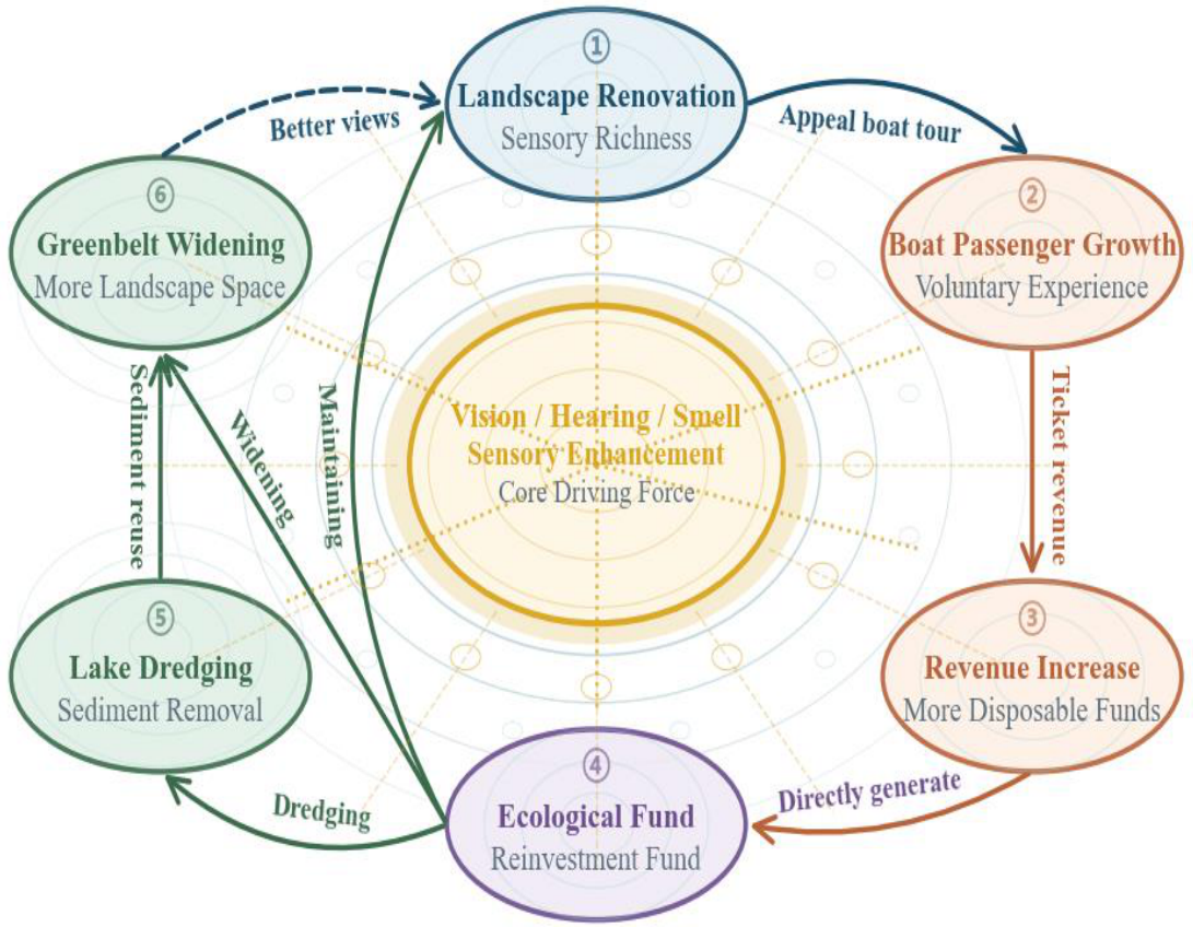
With sensory richness as the core driver, the framework constructs a closed loop from landscape improvement to capital return (Figure 5). Landscape management would enhance visitor experience, boosting cruise passenger flow and tourism consumption. Using visitor behavior data and seasonal passenger flow, a dynamic pricing and scheduling optimizer could adjust ticket prices and boat schedules in real time, improving operational efficiency and revenue. This data-driven revenue model aligns with evidence that integrating behavior tracking with dynamic pricing can align economic returns with real-time demand while minimizing waste [22].
Incremental revenue would go into a special fund for landscape maintenance and expansion. The process has three stages.
Short term (2–3 years): Maintenance and diversity enhancement. Focus on maintenance and plant diversity. Taking advantage of the lake’s relative isolation, high-value plant species could be introduced without risk of human disturbance. The goal is a structurally stable, diverse plant community that supports flora and fauna while enhancing sensory richness and ecological carrying capacity.
Medium term (3–5 years): Sediment dredging and terrain Restoration. Under normal lake operations and ecological safety requirements, sediment dredging would occur during non-flood seasons or low-water periods based on dynamic monitoring. Dredged sediment meeting resource standards would undergo on-site screening and testing, then be transported to areas adjacent to the landscape belt for terrain Restoration and micro-topography construction. This would lay the spatial foundation for gradual greenbelt expansion.
Long term (5+ years): Spatial expansion and multifunctional upgrading. New land from gradual sediment accumulation would be used for systematic renovation and upgrading. Multifunctional areas—flower nurseries, research bases, study bases—would be developed according to micro-topographical conditions. This would shift the landscape belt from a purely ecological space to one integrating ecology, education, and experiential activities, expanding visitor engagement scenarios and consumption opportunities.
In this closed loop, data monitoring and scheduling at each link, combined with cross-link collaboration and dynamic optimization, would maintain positive operation. This echoes recent calls for stakeholder-centric collaborative frameworks in circular construction, where successful circularity depends on aligned incentives and transparent data sharing among multiple actors [23].
4. Discussion
4.1. Intervention Mechanisms in Sensory Restoration and Behavioral Transformation
A key challenge in sensory restoration is maintaining year-round visual appeal without physical intervention. Conventional landscape planning often relies on static planting schemes that ignore seasonal phenological dynamics [9,10]. By processing six years of phenological data, the proposed system generates seasonal color themes and transition zones that ensure visual continuity and avoid incompatible color combinations. This data-driven approach replaces subjective intuition with systematic optimization, aligning with emerging methods in landscape perception research [9,24]. The landscape belt could thus sustain visitor appeal across all seasons without requiring physical access.
In behavioral transformation, the central question is how sensory enhancement leads to active engagement rather than passive observation. Environmental psychology suggests that sensory stimuli alone do not trigger behavioral change; guidance and interpretation are necessary to turn perception into action [16,17]. The need for explicit design-health frameworks has also been highlighted in recent landscape and health reviews [6]. The framework’s proposed WeChat-based guidance system provides differentiated guidance for walking, bridge-viewing, and boating. For shoreline visitors, it recommends optimal daily viewing sections based on plant layering and seasonal highlights. For bridge visitors, it highlights color zones and transition points from overhead. For boat passengers, it delivers real-time commentary integrating visual, auditory, and spatial perceptions with phenological timing. This targeted guidance converts sensory exposure into active engagement, addressing the gap between sensory richness and behavioral response identified in prior studies [5,10].
4.2. Closed-Loop Implementation of Economic Generation and Ecological Reinvestment
A central challenge in economic generation is aligning revenue models with actual visitor demand. Traditional tourism revenue models rely on static pricing and assumption-based forecasting [25,26,27], which can be inefficient. The framework’s dynamic pricing and scheduling optimizer would capture visitor behavioral data—preferred viewing times, routes, sensory triggers—and adjust ticket prices and boat schedules in real time. This approach is consistent with smart tourism advances that use real-time data to improve operational efficiency [28,29]. Willingness to pay for boat tours would derive from observed behavior rather than assumptions, ensuring that economic returns reflect actual demand.
In ecological reinvestment, a persistent challenge is the disconnect between ecological maintenance and funding sources. Dredging operations have historically depended on government funding, leading to unsustainable maintenance regimes [1,2]. The framework addresses this by envisioning a resource coordinator who uses dynamic sediment accumulation monitoring to schedule interventions during non-flood seasons or low-water windows, minimizing disturbance to aquatic ecosystems. Dredged sediment that meets resource standards would be screened, tested, and transported to areas adjacent to the landscape belt for terrain restoration and micro-topography construction, turning waste into a recoverable resource. This approach aligns with circular economy principles in urban water management [15,30].
4.3. Transferability, Practical Implications, and Theoretical Contributions
The four-stage cyclical mechanism offers a response to the core dilemma of inaccessible urban waterfronts: how to generate economic value without compromising ecological integrity. The framework‘s components – phenological database, multimodal guidance mechanism, behavioral feedback system, resource coordination modules – can be conceptually adapted to other waterfront spaces constrained by ecological or safety restrictions. Adaptation would require localized calibration and physical infrastructure for data collection and system coordination. This reliance on upfront intervention points to a limitation: the framework does not eliminate the need for on-site modification but repositions it as a prerequisite for data-driven management. The Xianyang Lake case serves as a hypothetical demonstrative application, showing operational logic rather than validating outcomes. Rigorous empirical validation would require longitudinal data and controlled experiments across different geographic and regulatory contexts.
The framework offers three practical implications for environmental managers working with inaccessible urban blue-green spaces. First, for sites where physical access is infeasible due to ecological sensitivity or flood risk, sensory restoration provides a low-intervention alternative. Managers can use phenological data and the proposed AHP-based criteria to prioritize plant species that deliver year-round visual, olfactory, and auditory engagement – without constructing paths, platforms, or other intrusive infrastructure. This is particularly relevant for protected areas where construction is restricted. Second, the behavioral-economic linkage (sensory exposure - willingness to pay) suggests a self-sustaining revenue model that reduces dependence on public subsidy. By designing differentiated guidance systems – such as a mobile application that provides real-time commentary and route recommendations – managers can convert passive viewing into paid activities (e.g., boat tours, guided walks), generating revenue for ongoing maintenance and restoration. This mechanism addresses the chronic funding gap faced by many public green spaces. Third, the sediment reuse loop operationalizes circular economy principles at the site level. Instead of disposing dredged material as waste – which incurs landfill costs and environmental externalities – managers can repurpose it for greenbelt expansion, terrain reshaping, or micro-topography construction. This closes the material loop while reducing operational expenses and enhancing ecological heterogeneity.
This paper makes three theoretical contributions to environmental planning and management. First, by demonstrating that sensory richness can generate spatial value without physical entry, the framework expands the concept of “accessibility” beyond its conventional physical interpretation. This challenges a long-standing assumption in urban design and planning literature [3,4] that physical presence is necessary for spatial attachment and value formation. The framework opens a new research agenda on sensory substitution in space activation – investigating how other sensory modalities (e.g., soundscape, smellscape) might compensate for restricted physical access. Second, the paper specifies a testable behavioral-economic pathway: sensory exposure - positive affect - willingness to pay. This bridges two previously disconnected literatures: multisensory urbanism [5], which has documented sensory benefits but stopped at subjective well-being, and environmental economics [19,21], which has modeled willingness to pay for ecosystem services but rarely incorporated specific sensory attributes. The framework provides a theoretical foundation for future empirical research on nature-based tourism and green space valuation. Third, the combination of AHP and k-means clustering applied to six years of phenological data offers a systematic, data-driven alternative to intuition-based planting design. This method can be applied to other urban green spaces requiring year-round sensory engagement – including parks, greenways, and ecological corridors. It contributes to the growing field of data-informed environmental management, where long-term monitoring data are used to optimize design and management decisions rather than relying on static plans or designer judgment.
5. Conclusions
This paper has developed a conceptual four-stage socio-ecological framework for managing inaccessible urban waterfront spaces. The framework integrates sensory restoration, behavioral transformation, economic generation, and ecological reinvestment. Using Xianyang Lake in China as a demonstrative context, the study grounds its framework in six years of phenological observations from 36 plant species and shows how the framework would operate. It does not claim empirical validation.
The paper makes three theoretical contributions to environmental planning and management. First, by demonstrating that sensory richness can generate spatial value without physical entry, it challenges the long-standing assumption that physical accessibility is necessary for spatial attachment and value formation, introducing the concept of sensory accessibility as an alternative management principle. Second, it specifies a testable behavioral-economic pathway from sensory exposure to willingness to pay, bridging multisensory urbanism and environmental economics. Third, it offers a replicable data-driven method – combining AHP and k-means clustering applied to phenological data – as a systematic alternative to intuition-based planting design.
For environmental managers, the framework provides three low-intervention strategies for ecologically sensitive waterfronts where physical access is infeasible. Sensory restoration offers a pathway to generate public engagement without intrusive infrastructure. The behavioral-economic linkage suggests a self-sustaining revenue model that reduces dependence on public subsidy. The sediment reuse loop operationalizes circular economy principles at the site level, turning dredged material into a resource for greenbelt expansion.
The framework remains conceptual and requires empirical validation. The Xianyang Lake case serves as a hypothetical demonstration rather than a validated outcome. Future research should prioritize: (1) pilot deployment of the guidance system in accessible waterfront sections to test behavioral response; (2) longitudinal monitoring of ecological indicators (bird diversity, plant survival, water quality) under sensory-driven management; and (3) cost-benefit analysis of sediment reuse versus conventional disposal. The framework‘s modular components – phenological database, multimodal guidance logic, behavioral feedback model, resource coordination algorithm – can be calibrated to local conditions, but their effectiveness requires empirical testing through pilot deployment.
Author Contributions
Conceptualization, X.D.; methodology, X.D.; data curation, X.D.; writing—original draft preparation, X.D.; visualization, X.D.; funding acquisition, X.D., Y.Y. and P.Z.; writing—review and editing, Y.Y., P.Z. and X.L.; supervision, X.L.; project administration, X.L. All authors have read and agreed to the published version of the manuscript.
Funding
This research was funded by the Ningxia Hui Autonomous Region Key R&D Program, grant number 2026BEG02059; the Key Scientific Research Project of Higher Education Institutions in Henan Province, grant number 25A170020; the Ningxia Water Resources Research Institute, grant number SKYZY-2025004; and the National Natural Science Foundation of China, grant number U2243210.
Data Availability Statement
Data will be made available on request.
Acknowledgments
The authors appreciate the administrative support provided by Xianyang Lake Scenic Area for field investigation and the technical assistance in phenological data collation. During the preparation of this manuscript, the authors used DeepSeek AI for the purposes of polishing English writing and assisting in the initial layout of research framework diagrams. The authors have reviewed and edited the output and take full responsibility for the content of this publication.
Conflicts of Interest
The authors declare no conflicts of interest.
References
- Hysa, A.; Lowe, R.; Geist, J. Waterfront usage trends across German metropolitan areas: A social-ecological perspective to urban blue-green infrastructure connectivity. Landsc. Urban Plan. 2025, 260, 105369. [Google Scholar] [CrossRef]
- Yao, G.; Zhang, M. Urban-water symbiosis paradigm from the perspective of spatial-temporal integration: A case study of the improvement design practice of Qiantang Riverside (Binjiang Section) in Hangzhou. Contemp. Archit. 2025, (6), 63–68. [Google Scholar]
- Lynch, K. The Image of the City; MIT Press: Cambridge, MA, USA, 1960. [Google Scholar]
- Gehl, J. Life Between Buildings: Using Public Space, 6th ed.; Island Press: Washington, DC, USA, 2011. [Google Scholar]
- Degen, M.M.; Rose, G. The New Urban Aesthetic: Digital Experiences of Urban Change; Bloomsbury Visual Arts: London, UK, 2022. [Google Scholar]
- Zhu, Q.; Yao, P.; Li, J. The effect of nature-based landscape design on human health and well-being: A thematic synthesis. J. Environ. Eng. Landsc. Manag. 2025, 33(1), 55–71. [Google Scholar] [CrossRef]
- Wang, Z.; et al. Sediment management in urban rivers: A review of challenges and opportunities. J. Environ. Manag. 2020, 264, 110–119. [Google Scholar]
- Ding, X.; Yu, Y.; Liu, X.; et al. Ecological dredging and landscape transformation: A sustainable approach to enhancing urban green spaces and forest ecosystems in Xianyang Lake. Sustain. For. 2025, 8(1), 11532. [Google Scholar] [CrossRef]
- Li, X.; Wu, D.; Li, J.; et al. Evaluation of landscape visual perception of urban riverfront greenways based on deep learning. J. Beijing For. Univ. 2021, 43(12), 93–104. [Google Scholar]
- Cheng, X.; Cong, J.; Wang, J.; Chen, J. Evaluation on public perception of naturalness of autumn landscape in urban waterfront spaces based on natural aesthetics: A case study of the Huangpu River in Shanghai. Landsc. Archit. 2025, 32(11), 120–129. [Google Scholar] [CrossRef]
- Wu, Z. Translation, presentation, awakening, and activation: Urban memory museum in the micro-renewal of Shanghai Yuyuan Road. Archit. Tech. 2023, (S2), 156–160. [Google Scholar]
- Dong, Y.; Yu, F. A study on public space creation based on ‘embodied presence’. Design 2025, 38(24), 62–65. [Google Scholar]
- Cui, X. Visual healing in the digital age: Art intervention and community reconstruction empowered by technology. Mass Lit. Art. 2025, (23), 85–88. [Google Scholar]
- Ding, X.; Yu, Y.; Liu, X. Ecological dredging and landscape transformation: A sustainable approach to enhancing urban green spaces and forest ecosystems in Xianyang Lake. Sustain. For. 2025, 8(1), 11532. [Google Scholar] [CrossRef]
- Yildirim, M.; Globa, A.; Gocer, O.; Brambilla, A. Multisensory nature exposure in the workplace: Exploring the restorative benefits of smell experiences. Build. Environ. 2024, 262, 111841. [Google Scholar] [CrossRef]
- Bratman, G.N.; Bembibre, C.; Daily, G.C.; Doty, R.L.; Hummel, T.; Jacobs, L.F.; Kahn, P.H.; Lashus, C.; Majid, A.; Miller, J.D.; et al. Nature and human well-being: The olfactory pathway. Sci. Adv. 2024, 10, eadn3028. [Google Scholar] [CrossRef] [PubMed]
- Wu, J.; Wang, Q.; Xu, C.; Lun, X.; Wang, L.; Gao, Y.; Huang, L.; Zhang, Q.; Li, L.; Liu, B.; et al. Biogenic volatile organic compounds in forest therapy base: A source of air pollutants or a healthcare function? Sci. Total Environ. 2024, 931, 172944. [Google Scholar] [CrossRef] [PubMed]
- Wang, C.; Gao, B.; Hao, Z.; Li, L.; Yang, L.; Chen, W.Y.; Pei, N. Plant smellscape: A key avenue to connect nature and human well-being. Urban For. Urban Green. 2025, 107, 128757. [Google Scholar] [CrossRef]
- Abdeta, D. Willingness to pay for forest conservation in developing countries: A systematic literature review. Environ. Sustain. Indic. 2022, 16, 100201. [Google Scholar] [CrossRef]
- Djahangard, M.; Buckwitz, S.; Hioki, C.; He, J.; Zhou, Z.; Zhang, H.; Yousefpour, R. A global comparative analysis of local recreation behaviors and values in peri-urban forests. Environ. Sustain. Indic. 2024, 24, 100525. [Google Scholar] [CrossRef]
- Bösch, M.; Elsasser, P.; Franz, K.; Lorenz, M.; Moning, C.; Olschewski, R.; Rödl, A.; Schneider, H.; Schröppel, B.; Weller, P. Forest ecosystem services in rural areas of Germany: Insights from the national TEEB study. Ecosyst. Serv. 2018, 31, 77–83. [Google Scholar] [CrossRef]
- Chen, Y.; Hou, Y.; Lyu, J. Integrating the IoT and new energy to promote a sustainable low-carbon economy. Sustainability 2026, 17(15), 6755. [Google Scholar] [CrossRef]
- Ababio, B.K.; Lu, W.; Agyekum, K.; Ghansah, F.A. Enhancing circular construction through procurement: A conceptual stakeholder-centric collaborative framework for sustainable outcomes. Environ. Impact Assess. Rev. 2026, 112, 107784. [Google Scholar] [CrossRef]
- Cai, J.; Xu, J.; Wu, Y.; et al. Nonlinear effects of visual perception in coastal recreational spaces on user experience: A Dalian-based empirical study using social media data. J. Hum. Settl. West China 2025, 40(6), 45–53. [Google Scholar]
- Jin, C.; Lu, Y.; Zhang, L.; et al. Analysis of scenic spots accessibility based on road network: A case study of Nanjing urban area. Geogr. Res. 2009, 28(1), 246–256. [Google Scholar]
- Long, W.; Ng, S.T.; Lu, W.; Mora, L.; Bao, Z. Deciphering how digital functions enable circular economy practices in construction: A critical review of recent progress and future outlook. Environ. Impact Assess. Rev. 2025, 113, 107889. [Google Scholar] [CrossRef]
- Zhang, S.; Liu, C.; Yang, Z. Regional sharing of 5A scenic spots in multi-topographic provinces based on water-land transportation accessibility: A case study of Hubei Province. Resour. Dev. Mark. 2024, 40(3), 456–464. [Google Scholar]
- Zou, H.; Qiu, W.; Hu, M. Spatial accessibility of Wuhan tourism based on tourism image big data. Sci. Geogr. Sin. 2023, 43(5), 821–830. [Google Scholar]
- Jiang, M.; Liu, Y.; Wei, X. The impact of urban compactness on spatial accessibility of urban public service facilities. Urban Plan. Forum 2024, (2), 78–86. [Google Scholar]
- Zhang, J.; Chen, D.; Huang, R.J. A study on the optimization of the dynamic visual quantitative. Buildings 2026, 16(1), 93. [Google Scholar] [CrossRef]
Figure 1.
Common characteristics of a category of inaccessible urban waterfront spaces.
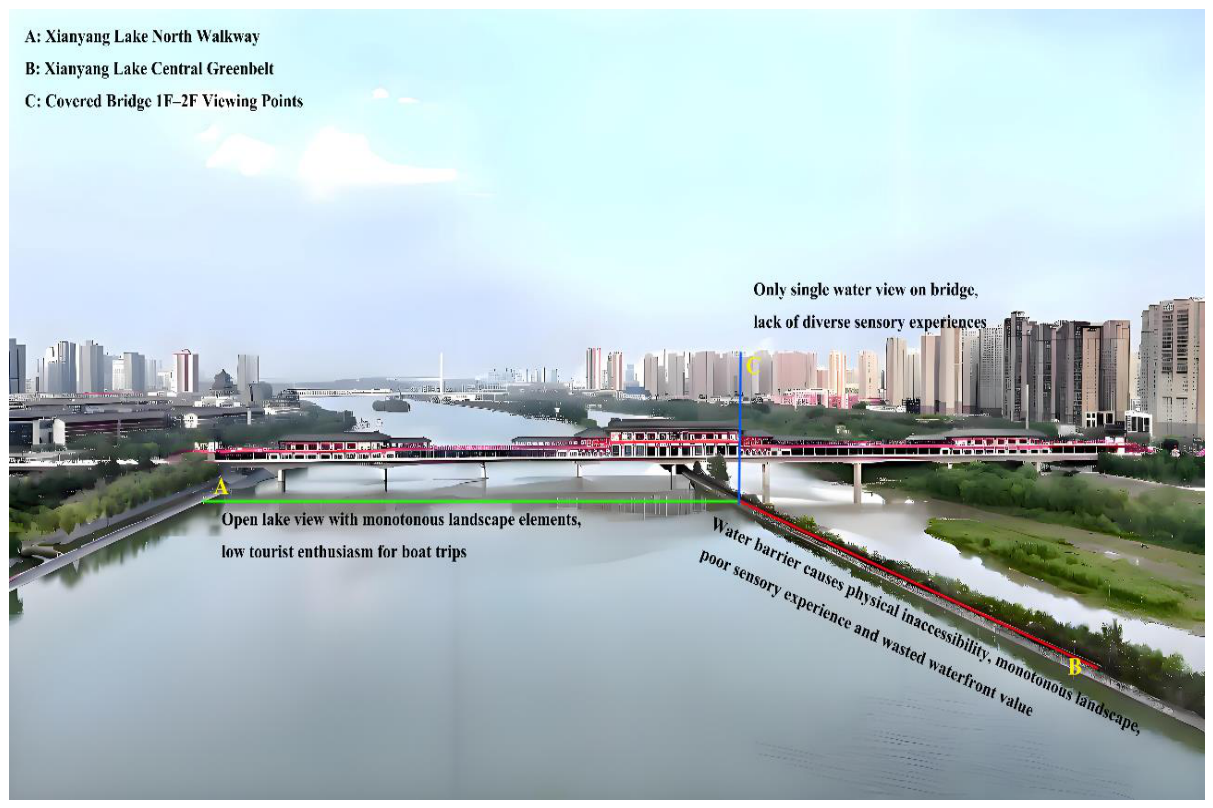
Figure 2.
Multidimensional Phenology of Selected Plants in Xianyang Lake’s Central Greenbelt.
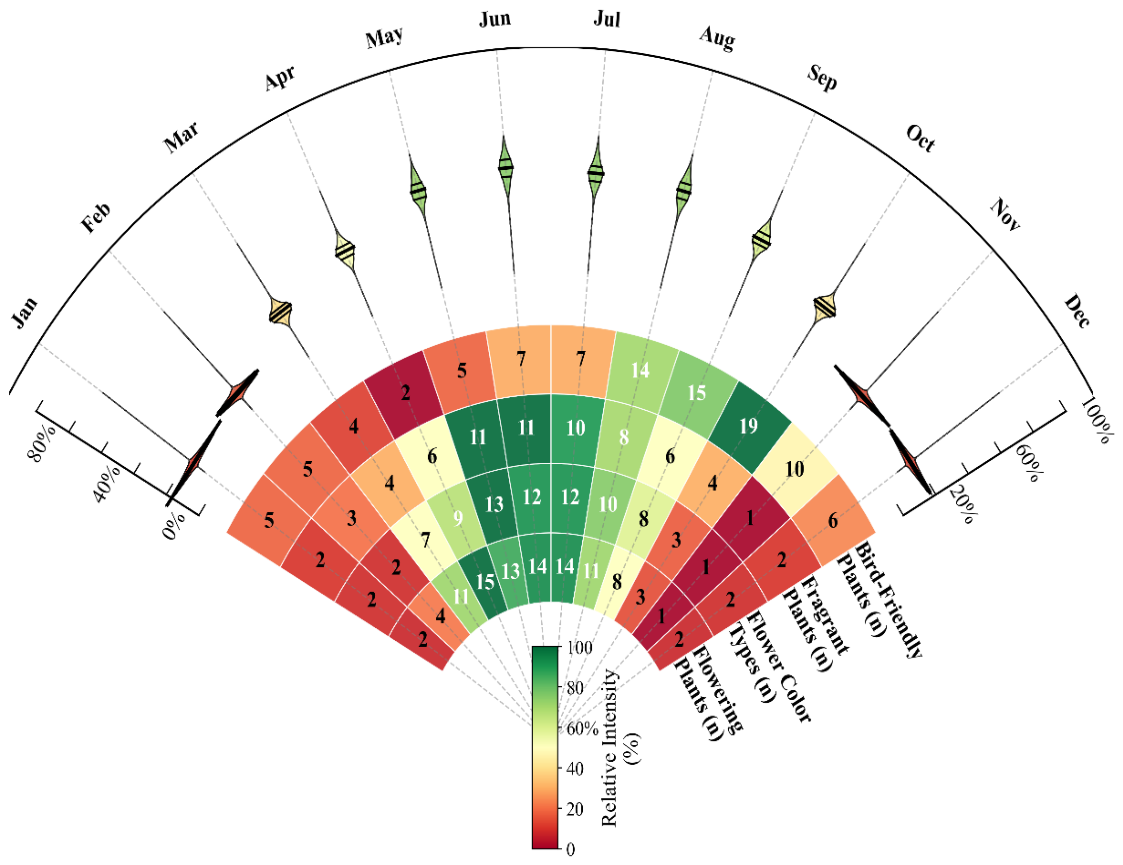
Figure 3.
Integrated Walkway–Bridge–Boat Experience in Xianyang Lake’s Central Greenbelt.
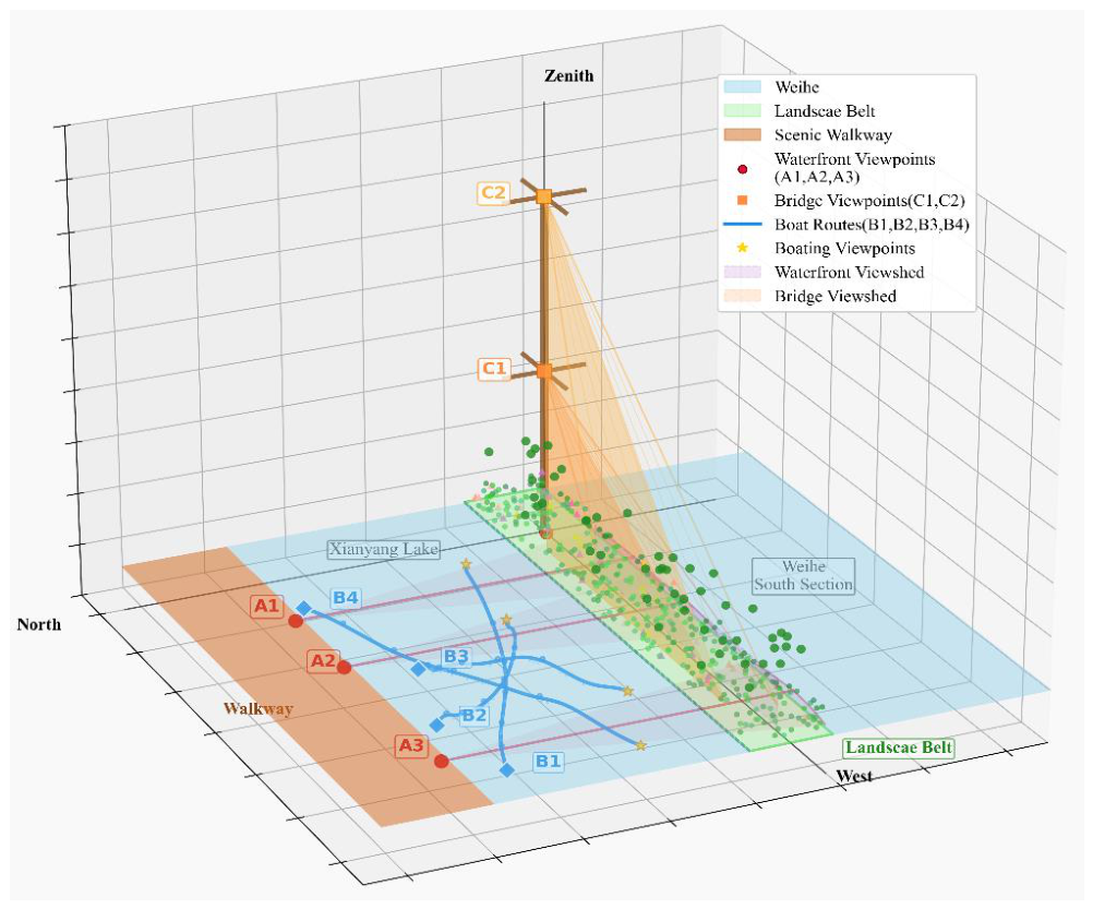
Figure 4.
Sensory Progression and Behavioral Transformation in the Renovation Greenbelt.
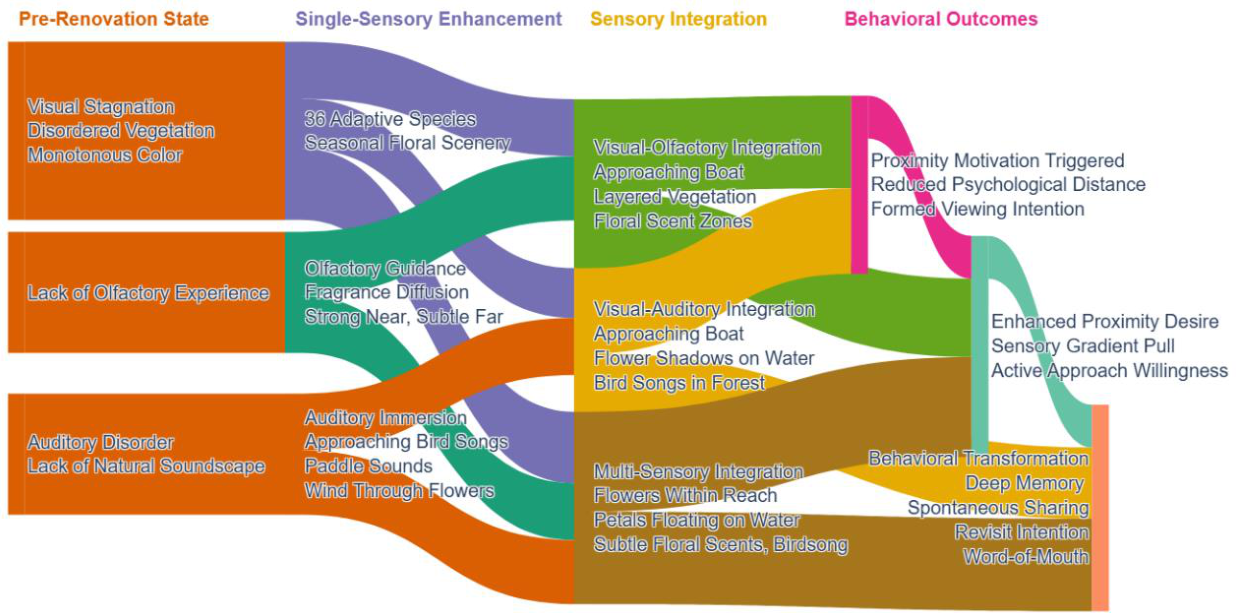
Figure 5.
Sensory-Driven Enhancement and Ecological Reinvestment Cycle.
Disclaimer/Publisher’s Note: The statements, opinions and data contained in all publications are solely those of the individual author(s) and contributor(s) and not of MDPI and/or the editor(s). MDPI and/or the editor(s) disclaim responsibility for any injury to people or property resulting from any ideas, methods, instructions or products referred to in the content. |
© 2026 by the authors. Licensee MDPI, Basel, Switzerland. This article is an open access article distributed under the terms and conditions of the Creative Commons Attribution (CC BY) license (http://creativecommons.org/licenses/by/4.0/).
Copyright: This open access article is published under a Creative Commons CC BY 4.0 license, which permit the free download, distribution, and reuse, provided that the author and preprint are cited in any reuse.