
Submitted:
28 July 2026
Posted:
29 July 2026
You are already at the latest version
Abstract
Analytical categories traditionally used to describe urban complexity—boundaries, fragmentation, segregation, enclaves—tend to portray spatial divisions as stable entities, privileging discontinuity over the relational processes through which it is produced. This limitation is particularly evident in cities marked by prolonged political instability, overlapping governance, or accelerated transformation. This article proposes the socio-spatial interface as a relational analytical framework that reframes rather than replaces the notion of boundary, understood as a configuration through which spatial forms, everyday practices, institutional arrangements, power relations, and historical conditions interact. Drawing on Lefebvre, Massey, de Certeau, and Bourdieu, and adopting a situated epistemology informed by Wittgenstein and Rancière, the article develops a four-dimensional methodological framework—institutional arrangements, material configurations, everyday practices and mobilities, and representations/memories/affects—derived from a doctoral fieldwork combining institutional documents, observation, a mobility questionnaire, in-depth interviews, and mental mapping. The framework is applied to three emblematic interfaces in Beirut—Chiyah–Aïn el-Remmaneh, Furn el-Chebbak, and Ghobeiry—showing how the same relational structure produces markedly different configurations of separation, hybridity, and negotiated proximity. The article contributes a situated approach to territorial analysis capable of informing architectural and urban design without reducing urban complexity to fixed spatial classifications.
Keywords:
socio-spatial interface
; relational epistemology
; urban boundaries
; territorial fragmentation
; Beirut
; situated methodology
; everyday practices
; urban theory
1. Introduction
Architectural and urban analysis begins with an act of reading. Before proposing interventions, defining programmes, or producing spatial representations, architects and urban researchers seek to interpret the conditions through which territories are organised, experienced, and transformed. Yet the analytical categories traditionally mobilised to describe urban complexity—such as boundaries, fragmentation, segregation, enclaves, or transition zones—often portray spatial divisions as relatively stable entities. While these concepts have significantly advanced the understanding of differentiated urban environments, they tend to privilege the identification of spatial discontinuities over the relational processes through which these discontinuities are continuously produced, negotiated, transformed, or suspended.
This limitation becomes particularly evident in cities characterised by prolonged political instability, overlapping systems of governance, conflict, or accelerated urban transformation. Under such conditions, territorial divisions cannot be understood solely through their physical or administrative manifestations. Their significance depends equally on the practices of those who inhabit, traverse, avoid, negotiate, or appropriate them. A street, a neighbourhood edge, or a public space may alternately function as a connector, a threshold, a place of encounter, or a line of separation depending on the actors involved, the temporal context, and the broader social and political conditions. Consequently, the challenge is not simply to locate spatial divisions but to understand how they emerge, under which conditions they persist, and through which practices they are reproduced or transformed.
This question is particularly relevant to architecture. Reading a territory is not a neutral act of description but an interpretative process that shapes how spatial problems are formulated and, ultimately, how design responses are conceived. Analytical frameworks that reduce urban territories to fixed categories risk overlooking the evolving relationships through which space is socially produced and experienced. As Lefebvre (1991) argues, space is not a passive container but a social product resulting from the interaction between material forms, representations, and lived practices. Similarly, Massey (2005) conceptualises places as relational constellations whose meanings remain open and continuously reconfigured rather than bounded and self-contained entities.
From this perspective, the persistence or transformation of urban divisions cannot be explained solely through their physical configuration. Everyday practices play a decisive role in shaping socio-spatial relations. De Certeau (1984) demonstrates how ordinary users constantly reinterpret institutional spatial orders through daily tactics, while Bourdieu (1977) shows that spatial practices are structured by habitus and by unequal distributions of economic, social, cultural, and symbolic capital. Consequently, urban boundaries are not simply material realities; they are continuously reproduced, negotiated, contested, or displaced through practice. Their meaning is therefore contingent rather than inherent.
Although the notion of the socio-spatial interface has increasingly appeared in discussions of urban interaction, transition, and negotiation, it is often employed descriptively rather than analytically. Interfaces are frequently treated as identifiable spatial zones whose characteristics can be objectively mapped. Such an understanding risks reproducing the very limitation it seeks to overcome by transforming interfaces into another fixed territorial category. This article argues instead that socio-spatial interfaces should be understood as relational configurations whose existence and significance emerge through the interaction between spatial forms, everyday practices, institutional arrangements, power relations, and historical conditions. They are not permanent attributes of places but contingent conditions whose meanings evolve over time.
Accordingly, this article does not seek to establish a universal definition or typology of socio-spatial interfaces. Rather, it proposes a relational framework for reading them. The emphasis deliberately shifts from the identification of spatial objects to the interpretation of relational processes. The objective is therefore not to determine where interfaces are located, but to understand under which circumstances they become meaningful, how they are reproduced through everyday practices, and how they are transformed as social, political, and spatial conditions evolve. In doing so, the article contributes both to architectural theory and to urban research by proposing a situated approach capable of informing territorial analysis without reducing urban complexity to fixed spatial classifications.
The discussion unfolds in four stages. The first revisits the concept of the socio-spatial interface and develops its theoretical foundations from a relational perspective. The second examines the epistemological implications of interpreting interfaces as situated and contingent rather than fixed spatial realities. Building upon this position, the third section develops a methodological framework for reading socio-spatial interfaces through multiple analytical dimensions. Finally, selected examples from Beirut illustrate how this framework may support the interpretation of evolving territorial configurations in contexts marked by fragmentation, negotiation, and continuous transformation.
2. Beyond Boundaries: Socio-Spatial Interfaces as a Relational Framework
2.1. From Boundaries to Interfaces
Urban territories have traditionally been interpreted through notions such as boundaries, borders, discontinuities and fragmentation. These concepts have proved essential for understanding how political, institutional and socio-cultural differences shape territorial organisation. Whether conceived as political constructions (Ancel, 1938; Anderson, 1997; Kolossov, 2005), socio-cultural differentiations (Claval, 1973), or socio-spatial discontinuities (Brunet, 1968; Reynaud, 1979), boundaries have long been approached as structuring elements through which territories are organised, hierarchised and governed. They materialise relations of power while simultaneously defining conditions of inclusion, exclusion and territorial control.
Yet, interpreting urban territories exclusively through boundaries also presents important limitations. Such perspectives frequently privilege territorial differentiation over the relational dynamics through which these differentiations are continuously produced and transformed. As numerous studies on Beirut illustrate, analyses have predominantly emphasised urban fragmentation, sectarian divisions and territorial enclavement (Davie, 1994; Farah, 2011; Fawaz, 2008; Verdeil, 2017; Bou Akar, 2012), while paying comparatively less attention to the interstitial spaces where encounters, negotiations and everyday interactions continue to occur. This predominance of binary readings risks obscuring the complexity of urban life by reducing metropolitan space to relatively stable territorial entities.
This article therefore argues that the concept of the socio-spatial interface provides a more productive analytical framework. Rather than replacing the notion of the boundary, the interface reframes it. An interface emerges from a situation of discontinuity but cannot be reduced to that discontinuity. It simultaneously contains separation and interaction, rupture and exchange, differentiation and interdependence (Chapelon et al., 2008; Lampin-Maillet et al., 2010). As such, it constitutes not merely a spatial limit but a socio-spatial configuration through which heterogeneous actors, practices and territorial logics encounter one another.
Figure 1 summarises this repositioning. The same spatial discontinuity can be read in two ways. A boundary-based reading proceeds toward fragmentation and enclavement, ultimately classifying the discontinuity as a fixed, self-contained territorial category. An interface-based reading, by contrast, holds separation and interaction together from the outset, examines how institutions, materiality, everyday practices, and representations jointly produce the discontinuity, and arrives at a configuration that is contingent and evolving rather than settled. The interface does not deny the boundary's existence; it reframes what follows analytically from recognising one.
Understanding interfaces therefore requires moving beyond a substantial conception of territory towards a relational perspective. Following Massey (1994, 2005), places are not self-contained entities but open configurations produced through multiple and evolving social relations. Similarly, Vanier (2008) proposes moving beyond the opposition between territorial anchorage and mobility, while Hudson (2004) and Jones (2009) question the dichotomy between stable territorial structures and relational processes. This article adopts this intermediate position. Socio-spatial interfaces are understood neither as permanent territorial objects nor as entirely fluid interactions. Rather, they are relational configurations whose stability and meaning remain contingent upon the continuous interplay between material structures, institutional arrangements, social practices and historical conditions.
This perspective also extends Lefebvre's conception of the production of space. If space is simultaneously conceived, perceived and lived (Lefebvre, 1991), interfaces cannot be understood solely through their material form. They emerge through the articulation of planning decisions, institutional representations, everyday practices and symbolic appropriations. Kärrholm's (2007) interpretation of territorial production further reinforces this argument by showing that territories are continuously negotiated through representations, regulations and spatial practices rather than simply delimited by physical boundaries.
At the same time, socio-spatial interfaces cannot be understood independently from the practices through which they are enacted. Bourdieu's theory of practice demonstrates that spatial trajectories are structured by habitus and by unequal distributions of economic, social, cultural and symbolic capital (Bourdieu, 1977; 1980). Everyday mobilities therefore frequently reproduce existing socio-spatial distinctions. Yet reproduction is never complete. As de Certeau (1984) argues, ordinary users constantly reinterpret institutional spatial orders through tactical appropriations that circumvent, negotiate or temporarily suspend established territorial arrangements. Consequently, interfaces are not simply inherited structures; they are continuously reproduced, contested and transformed through everyday action.
This understanding has important epistemological consequences. The interface should not be treated as an object possessing intrinsic characteristics independently of the context in which it is observed. Rather, it should be understood as an analytical construct whose significance depends upon specific historical moments, particular configurations of actors and situated practices. Consequently, the same location may function as an interface under certain political or social conditions while losing this role under others. The objective is therefore not to identify fixed territorial entities but to interpret the conditions through which interfaces emerge, acquire meaning and evolve.
3. Reading Socio-Spatial Interfaces: Towards a Situated Epistemology
The previous section argued that socio-spatial interfaces should not be understood as fixed territorial entities but as relational configurations emerging from the interaction between material structures, institutional arrangements, everyday practices and historical conditions. Such a perspective, however, raises an important epistemological question: if interfaces are neither stable objects nor permanent territorial categories, how can they be studied?
This question requires moving beyond an object-based conception of spatial analysis. Traditional approaches generally assume that territorial categories exist prior to observation and that research consists primarily in identifying, describing and explaining them. Such an epistemological position implicitly assumes that space possesses stable properties that can be objectively classified. Yet relational understandings of space suggest the opposite. Spatial realities emerge through continuously evolving relations, making their interpretation necessarily situated, contingent and partial.
Accordingly, socio-spatial interfaces should not be conceived as empirical objects waiting to be discovered but as analytical constructs through which territorial relations become intelligible. Their existence cannot be established independently of the historical circumstances, actors, scales and practices through which they are observed. Rather than asking whether a place is objectively an interface, the relevant question becomes under which conditions does this place function as an interface, for whom, and through which social and spatial processes?
This shift echoes Wittgenstein's later philosophy of language. In the Philosophical Investigations, meaning is never inherent to words themselves but emerges through their use within specific language games (Wittgenstein, 1953). Likewise, socio-spatial interfaces possess no intrinsic meaning independent of the practices through which they are enacted. Their significance is constituted through situated interactions, institutional narratives, everyday mobilities, symbolic appropriations and collective memories. Consequently, interfaces cannot be defined once and for all; they acquire different meanings according to changing social contexts.
Such a perspective also resonates with Rancière's understanding of the distribution of the sensible. What becomes visible, intelligible or politically significant within space depends upon historically situated regimes of perception rather than upon objective spatial properties (Rancière, 2004). Reading socio-spatial interfaces therefore implies recognising that territorial realities are never entirely self-evident. Certain relations become visible while others remain invisible; some practices are institutionalised whereas others remain ordinary and therefore frequently escape conventional territorial analysis.
This epistemological position has important methodological implications. If interfaces emerge through relations rather than through fixed forms, no single source of information can adequately account for their complexity. Their interpretation necessarily requires crossing multiple forms of evidence capable of revealing complementary dimensions of territorial life. This principle already underpinned the methodological strategy developed in the doctoral research from which this article builds. Rather than privileging a single dataset, the research combined institutional documents, planning regulations, participant observation, spatial practices, questionnaires, in-depth interviews and mental maps in order to understand how interfaces were simultaneously produced by institutions and experienced by their users.
The importance of this methodological pluralism lies less in triangulation as a technique than in its epistemological rationale. Institutional documents reveal official territorial narratives and planning intentions; direct observation captures the material and sensory dimensions of space; mobility practices expose actual patterns of interaction; interviews provide access to situated interpretations; while mental maps reveal affective geographies and symbolic boundaries that remain largely invisible within conventional spatial analysis. Considered independently, each of these materials offers only a partial reading. Considered together, they reveal the relational processes through which socio-spatial interfaces are continuously reproduced and transformed.
This understanding also challenges conventional assumptions regarding territorial permanence. The doctoral research demonstrated that the same interface could alternately appear as a place of separation, coexistence, encounter or indifference depending on the practices performed, the identities of users, the prevailing political context and even particular moments of everyday life. Mobility patterns, affective attachments and spatial representations constantly modified the degree of porosity observed across the interface, making its configuration fundamentally dynamic rather than fixed.
Consequently, reading socio-spatial interfaces should not aim at producing universal territorial classifications. Instead, it seeks to understand how territorial configurations emerge through the continuous articulation of structures and practices, stability and transformation, institutional regulation and everyday negotiation. Knowledge therefore becomes necessarily situated. It remains anchored within particular historical, political and spatial contexts while retaining the possibility of informing comparative analyses across different cities.
This epistemological repositioning ultimately reframes the role of architectural and urban analysis itself. Rather than reducing territories to predefined categories, reading socio-spatial interfaces becomes an interpretative practice attentive to ambiguity, relationality and emergence. The objective is not to replace one territorial model with another, but to provide a conceptual framework capable of revealing forms of urban complexity that remain insufficiently captured by conventional categories such as fragmentation, segregation or boundary.
4. Materials and Methods: A Framework for Reading Socio-Spatial Interfaces
The relational epistemology developed in the previous section calls for a methodological approach capable of capturing the multiple processes through which socio-spatial interfaces are produced. If interfaces are understood not as fixed territorial entities but as relational configurations emerging from the interaction of social, political, material, and symbolic processes, their analysis cannot rely on isolated variables or predetermined spatial categories. Instead, it requires an interpretative framework that examines how these different dimensions intersect within specific territorial contexts.
Accordingly, socio-spatial interfaces are approached through four complementary analytical dimensions. The first concerns institutional arrangements, including governance structures, planning policies, administrative boundaries, and political decisions that shape territorial differentiation. The second addresses material configurations, referring to the spatial organization of the built environment, urban morphology, infrastructures, and public spaces that enable or constrain interactions. The third focuses on everyday practices and mobilities, examining how inhabitants negotiate, reproduce, or challenge territorial divisions through their daily movements and uses of space. Finally, representations, memories, and affective relations explore the symbolic and experiential meanings through which places are perceived, appropriated, and contested. Rather than constituting independent layers of analysis, these dimensions are understood as mutually constitutive, each acquiring significance through its relationship with the others. This analytical perspective builds upon the multi-method strategy developed in the doctoral research, where spatial analysis, field observations, interviews, and mental mapping were combined to examine the relational production of metropolitan space.
The framework proposed here should therefore be understood as an analytical lens rather than a prescriptive methodology. Its objective is not to classify interfaces according to fixed typologies, but to provide a coherent structure for interpreting the processes through which interfaces emerge, evolve, and are transformed over time. By integrating institutional, material, social, and symbolic dimensions within a single relational perspective, the framework remains sufficiently flexible to be applied across different urban contexts while preserving sensitivity to their historical and geographical specificities.
Figure 2 summarizes this conceptual framework. It illustrates how the ontological understanding of socio-spatial interfaces developed in Section 2 and the relational epistemology discussed in Section 3 converge into an analytical framework articulated around four interdependent dimensions. This framework provides the conceptual basis for the empirical reading of Beirut presented in the following section.
5. Results: Reading Beirut Through Socio-Spatial Interfaces
5.1. Beirut as a Relational Urban Territory
The proposed framework finds particular relevance in Beirut, a metropolitan context where fragmentation has often been interpreted through the language of boundaries, divisions, or enclaves. While these perspectives have provided important insights into the city's political and spatial history, they tend to privilege separation over interaction. A relational reading shifts the analytical focus from fixed territorial divisions to the multiple interfaces through which everyday urban life is continuously negotiated. Rather than viewing fragmentation as a static condition, Beirut can be understood as a constellation of socio-spatial interfaces whose forms and meanings vary according to institutional arrangements, material configurations, everyday practices, and symbolic representations.
The empirical material presented below draws on a doctoral fieldwork (Mezher, 2022) combining institutional and legal documents, direct and indirect observation, a mobility questionnaire administered to approximately sixty residents and users, and in-depth interviews (twenty to twenty-three per neighbourhood) accompanied by word-association and mental-mapping exercises. Rather than describing the metropolitan territory in general terms, this section organises the reading of Beirut around three emblematic interfaces, each combining the four analytical dimensions to a different degree and in a different configuration: Chiyah–Aïn el-Remmaneh, situated along the former civil-war demarcation line; Furn el-Chebbak, a commercial and leisure hub bordering it; and Ghobeiry, situated along the administrative boundary between the Beirut municipality and the southern suburb. Together, these three cases illustrate how the same relational framework produces markedly different socio-spatial configurations depending on the historical, institutional, and communal conditions in which each interface is embedded.
5.2. The Chiyah–Aïn el-Remmaneh Interface: Memory, Security, and Demographic Anxiety
Chiyah–Aïn el-Remmaneh borders the former demarcation line of the 1975–1990 civil war, the old Saïda road, which historically separated Christian East Beirut from Muslim West Beirut. Institutionally, the sector falls under the municipalities of Chiah and Furn el-Chebbak, whose electoral rolls indicate an overwhelmingly Christian population (respectively 86% and 96%). Since November 2019, the interface has also become the site of recurrent intercommunal clashes with the adjacent, predominantly Shiite districts of the southern suburb—incidents of intimidation, verbal and physical aggression, and the destruction of religious symbols have punctuated the period between November 2019 and June 2020, reinforcing the interface's institutional and political salience.
Materially, the interface is marked by an unusually dense inscription of communal symbols: graffiti of the Lebanese Forces' beveled cross and the Kataeb's stylised cedar, portraits of former militia leaders, flags and party banners proclaiming resilience and warning against intimidation, alongside memorials to militiamen who fell as 'martyrs' during the civil war. Marian shrines and statues of Christ and Catholic saints punctuate semi-public thresholds—building entrances, sidewalks, shopfronts—further inscribing a religious ambiance into the everyday landscape. Yet the same street also functioned, during the October 2019 uprising, as the setting for a striking transgression of communal boundaries, when residents of both the Christian and Shiite sides jointly protested against the established socio-political order—momentarily suspending, rather than reproducing, the very divisions the interface otherwise materialises.
At the level of everyday practices, mobility data reveal a persistent yet selective porosity. The old demarcation line remains among the most heavily used routes by residents of all three interfaces, contradicting any reading of the boundary as impermeable; crossing is nonetheless conditioned by the type of activity undertaken, with shopping (88% of respondents across the study area) far outweighing leisure or family visits as a motive for crossing into or out of the sector.
Representationally, the interface is experienced through a register the fieldwork identifies as a 'sticky place'—a location where the affective residue of war-related trauma persists independently of any present threat. An elderly resident of Aïn el-Remmaneh explained her growing unease at demographic change in openly securitising terms: 'The neighbourhood is overcrowded by the Shia community,' she noted, adding that the old demarcation line, which once 'protected [her] neighbourhood from violence during the civil war,' effectively no longer exists (woman, 62). A 73-year-old resident described reading building façades as a surveillance practice in itself: 'You just need to look at the balconies to know where Shia households live, because they are fitted with veils or privacy screens to shield themselves from view. I don't know what is hidden behind those curtains, or what these households intend.' Even among younger residents who expressed strong attachment to the neighbourhood, tension surfaces: a 28-year-old described having to send his dog away to a relative's house in Mount Lebanon 'to avoid conflicts with my Muslim neighbours,' concluding, 'I love this neighbourhood very much... but if the opportunity arises, I will move to a more tolerant one.'
5.3. The Furn el-Chebbak Interface: Commercial Hybridity and Selective Openness
Furn el-Chebbak occupies a comparable institutional position to Aïn el-Remmaneh—an administratively distinct, predominantly Christian municipality (96%) governed by local Christian elites—but its everyday functioning diverges sharply. Rather than being defined primarily through security or memorial registers, the sector operates as a metropolitan-scale attraction pole for leisure, dining, and specialised commerce, drawing residents and users from across the three neighbourhoods under study.
Materially, Furn el-Chebbak's commercial streets (notably Rue Damas) display a formal continuity with those of the adjacent, predominantly Muslim sectors—comparable street widths, built frontages, and shopfront strategies—while diverging in more subtle ambiental registers: shop signage is more frequently bilingual or trilingual (French/English alongside Arabic) than in Ghobeiry or Tarik el-Jdidé, and its bookshop stocks a more francophone, generalist catalogue oriented toward schoolbooks, in contrast with the Arabic-language literary catalogue of its counterpart in Tarik el-Jdidé. Its sociability spaces—cafés such as Hook and Aleph B—combine café, restaurant, and bar functions in a gender-mixed, hybrid format the fieldwork likens to Parisian sidewalk cafés or Berlin 'third places,' contrasting with the male-dominated, alcohol-free 'ahwa'-style cafés observed in Ghobeiry and Tarik el-Jdidé.
This material hybridity is corroborated by mobility patterns: shopping constitutes the dominant motive (near 55%) for Furn el-Chebbak residents to cross into Ghobeiry and the southwestern suburb for household goods, hardware, and groceries, while close to 30% travel to Tarik el-Jdidé specifically for spices and pastries—figures that sit uneasily alongside the openly hostile representations documented in interviews (see below), suggesting that utilitarian proximity and affective distance operate simultaneously rather than as mutually exclusive registers.
Representationally, Furn el-Chebbak is itself perceived by outside users in strongly positive terms—residents of Ghobeiry, for instance, systematically described it with neutral-to-positive qualifiers ('accessible', 'open', 'ordinary', 'calm'), a majority (15 of 21 respondents) rating it positively, which the fieldwork interprets as evidence that a form of commercially-mediated proximity can coexist with, and partially transcend, memories tied to the civil war. Yet the same interviews reveal how thoroughly the same neighbourhood is 'stuck' with negative affect when seen from the opposite direction: a majority of Furn el-Chebbak respondents described Ghobeiry using vocabulary of fear and disgust—'insecure', 'dangerous', 'hostile', 'dirty'—with several explicitly refusing any possibility of coexistence: 'It holds no interest to me... I cannot interact or live with them [referring to the Shiite community]' (man, 39). Notably, the same neighbourhood was also described, by two elderly residents, in terms of enduring affective attachment—one recalling 'her grandmother's beautiful house and its garden' despite her family's wartime displacement, and continuing to visit Ghobeiry 'to buy cheaper vegetables' and greet a childhood friend; another recalling 'the old orchards and racehorse stables' near the neighbourhood's hippodrome, and gatherings around the words of the Shiite Imam Moussa el-Sadr, whom he held in high esteem—illustrating how affective relations to the same interface diverge sharply along generational lines.
5.4. The Ghobeiry Interface: Political-Religious Governance and Ambivalent Proximity
Ghobeiry occupies a markedly different institutional position. Formally part of the southwestern suburb of Beirut, it is governed under the political and territorial influence of the Hezbollah and Amal movements, and its expansion beyond the historic boundaries of the southern suburb—into sectors of Aïn el-Remmaneh, Hadath, and Choueifat—has been documented as the product of targeted real-estate acquisition, differentiated zoning outcomes, and residential construction favouring the Shiite community (Bou Akar, 2012). Unlike the formally autonomous but centrally supervised municipal governance structure that applies to Furn el-Chebbak and Chiah, Ghobeiry's territorial logic is described as operating through 'contested spaces' where Hezbollah's influence, though present, does not amount to the exclusive territorial monopoly it exercises within the historic core of the southern suburb (Kastrissianakis, 2012).
Materially, Ghobeiry displays a comparably dense inscription of communal symbols to Aïn el-Remmaneh, but of an inverted political and religious register: banners and flags of the Amal Movement and Hezbollah, portraits of the Hezbollah secretary-general and of Imam Moussa el-Sadr, plaques marking the residences of party 'martyrs', and periodic motorcycle parades that function as symbolic demonstrations of force—occasionally provoking friction with adjacent Aïn el-Remmaneh. Quranic verses on banners, and predominantly dark-coloured hijab and abaya among women, distinguish the sector's everyday visual register from the more brightly coloured dress observed in Tarik el-Jdidé. Commercially, prices in Ghobeiry are noted to run consistently lower than in Furn el-Chebbak or Badaro, a differential the fieldwork identifies as a deliberate strategy for attracting a metropolitan-wide, cross-communal clientele rather than a purely local one.
Everyday mobility confirms this outward-oriented commercial logic: nearly 40% of Ghobeiry residents surveyed travel to Furn el-Chebbak's commercial centres for food, clothing and furnishings, while over 70% report visiting relatives in Tarik el-Jdidé—a figure the fieldwork attributes to longstanding intermarriage between the two Sunni and Shiite communities—indicating that kinship networks, more than institutional boundaries, structure the interface's actual porosity.
Representationally, Ghobeiry residents overwhelmingly describe their own neighbourhood in positive terms ('attractive', 'accessible', 'open', 'comfortable'), with 21 of 21 respondents rating it neutrally to very positively. Their relation to the adjacent, Sunni-majority Tarik el-Jdidé is more ambivalent: a minority explicitly refused any evaluation, citing intolerance toward the prevailing political and confessional order—'the political atmosphere doesn't suit me' (man, 30)—while a larger group described a form of passive sociability limited to specific kinship visits: 'I only go there to visit my uncle' (man, 41); 'I only go there to see my sister and a few friends' (woman, 63). This pattern illustrates how, within the same interface, institutional divisions, commercial hybridity, and kinship-based sociability coexist without resolving into either straightforward separation or straightforward integration.
5.5. Synthesis: Interfaces as Differentiated Relational Configurations
Table 1 summarises the four-dimensional reading of the three interfaces developed in Section 5.2, Section 5.3 and Section 5.4.
Read together, the three cases demonstrate that the same relational framework produces distinct socio-spatial outcomes depending on how its four dimensions combine. At Chiyah–Aïn el-Remmaneh, institutional history and collective memory dominate, producing an interface primarily legible through security anxiety and demographic surveillance, even as commercial mobility and, momentarily, political protest cut across it. At Furn el-Chebbak, material and commercial hybridity structure a porous, attraction-based interface whose openness coexists uneasily with sharply negative affective representations of its neighbours. At Ghobeiry, distinctive political governance and religious symbolism coexist with an outward-oriented commercial strategy and kinship-based visiting practices that produce porosity independently of, and sometimes despite, institutional and representational divisions. None of the three interfaces is reducible to a single register of separation or connection; each combines institutional, material, practice-based, and representational dimensions in a historically and locally specific configuration—confirming that socio-spatial interfaces are not fixed territorial objects but contingent, continuously negotiated relational constructs, as argued in Section 2 and Section 3.
6. Discussion
The fieldwork presented in Section 5 offers a reading of the three interfaces as they functioned prior to 2023. Since then, the escalation of regional conflict in 2024 has visibly affected the corridor in which these interfaces are situated: exposure to strikes has been concentrated in and around Ghobeiry, and displacement has been reported toward neighbouring sectors—including Furn el-Chebbak and Badaro—as well as toward more distant destinations across Lebanon and, in some cases, across the border. These developments postdate the doctoral fieldwork on which Section 5.2, Section 5.3 and Section 5.4 are based and were not observed through the same methods.
It is important to be explicit about the nature of the evidence involved here. Unlike the interviews, questionnaires, and direct observation conducted between 2017 and 2019, the post-2023 material referred to in this Discussion derives from indirect, secondary sources external to this study's original protocol—open conflict documentation, satellite imagery, and humanitarian displacement reporting—rather than from first-hand fieldwork conducted by the author under wartime conditions. Figure 3 and the interpretation that follows should therefore be read as an illustrative, lower-confidence extension of the framework developed in Section 4, useful for probing its analytical robustness, rather than as a fourth empirical case with the same evidentiary weight as those presented in Section 5.
With this caveat in mind, Figure 3 offers a schematic, relational reading of how the framework proposed in Section 4 might respond to conditions this disruptive. Rather than mapping territory, it represents the three interfaces as nodes and their porosity as edges, coded by intensity (line weight) and by the analytical dimension that appears to dominate the change observed (colour).
Read this way, the three interfaces do not respond uniformly to disruption. Between Chiyah–Aïn el-Remmaneh and Furn el-Chebbak, already the most porous pairing before 2024, porosity intensifies further—but its character shifts from routine, elective mobility to displacement-driven movement, indicating that the practices dimension can remain dominant even as its content is inverted from choice to necessity. Between Chiyah–Aïn el-Remmaneh and Ghobeiry, by contrast, porosity that was already conditional and selective before 2024 contracts sharply, as institutional and representational registers—security anxiety, demographic surveillance, strike exposure—come to override the negotiated, activity-dependent crossings documented in Section 5.2. Between Furn el-Chebbak and Ghobeiry, the previously reciprocal commercial exchange described in Section 5.3 and Section 5.4 persists in volume but loses its bidirectionality, becoming an asymmetric flow whose dominant register shifts from practices toward material and infrastructural conditions—which routes remain physically accessible—rather than consumer choice.
This reading suggests a refinement rather than a refutation of the framework proposed in Section 4: the same four dimensions remain analytically sufficient to describe each interface's behaviour, but their relative weighting is not fixed. Under acute disruption, institutional and material dimensions appear to gain explanatory weight relative to everyday practices and representations, even where—as at Chiyah–Aïn el-Remmaneh/Furn el-Chebbak—overall porosity increases rather than declines. This is consistent with the article's broader argument that interfaces are contingent, historically situated configurations rather than stable territorial objects (Section 2 and Section 3): the same relational structure can persist through crisis while the balance of forces that sustains it is substantially rearticulated.
Read against the theoretical framework developed in Section 2 and Section 3, the empirical material presented in Section 5 substantiates rather than merely illustrates the article's central claim. Lefebvre's (1991) argument that space is simultaneously conceived, perceived, and lived finds a concrete counterpart in the way each of the three interfaces combines institutional planning categories (conceived space), material street-level configurations (perceived space), and affective attachment or repulsion (lived space) without any one register fully determining the others. Similarly, Massey's (1994, 2005) relational conception of place—open, unbounded, constituted through intersecting trajectories rather than fixed extent—is borne out empirically by the mobility data in Section 5.2, Section 5.3 and Section 5.4: the old demarcation line functions simultaneously as the most heavily used route in the study area and as the site of its most securitised representations, a coexistence that a purely boundary-based reading would struggle to accommodate.
The fieldwork also confirms the productive tension between structure and practice identified through Bourdieu (1977, 1980) and de Certeau (1984). Bourdieu's account of habitus helps explain the durability of avoidance patterns—for instance, the persistence, across generations, of securitised readings of Ghobeiry among Furn el-Chebbak residents—while de Certeau's attention to tactical appropriation is legible in the transgressive, if short-lived, transcommunal solidarities documented at Chiyah–Aïn el-Remmaneh during the October 2019 uprising. Neither register alone accounts for the interface's behaviour: reproduction and transgression coexist within the same spatial configuration, at times within the same individual's account of it, as several of the interview excerpts illustrate.
Read through Wittgenstein's (1953) notion that meaning is constituted through use rather than given in advance, the same street, café, or shopfront takes on different meanings depending on who crosses it and why—commercial artery for one group, threshold of danger for another, site of enduring affective attachment for a third, sometimes within the same generation of the same neighbourhood, as the contrasting accounts of Ghobeiry offered by younger and older Furn el-Chebbak residents demonstrate (Section 5.3). This variability is not a methodological weakness to be resolved through better measurement; following Rancière (2004), it reflects differentiated regimes of perception through which some relations become visible—and politically significant—while others remain part of an unremarked, ordinary everyday that conventional territorial analysis tends to miss.
Several limitations qualify these findings. First, the fieldwork on which Section 5 is based was conducted between 2017 and 2019, a period of relative, if fragile, stability; the framework's application to acute crisis conditions in Section 6 rests on indirect, secondary evidence of a different evidentiary status, as noted there, and should not be read as a fourth primary case. Second, the researcher's own positionality—a Christian woman from East Beirut affiliated with a foreign institution—shaped access to certain spaces and interlocutors, particularly in the southern suburb, in ways that may have inflected both the material collected and its interpretation; this is acknowledged rather than resolved. Third, the three interfaces examined here were selected for their emblematic character within a broader corridor and do not exhaust the range of socio-spatial configurations found across Beirut; the framework's applicability to less politically charged or less historically marked interfaces remains to be tested. Finally, the mobility questionnaire's sample size (approximately twenty participants per neighbourhood) supports a qualitative, illustrative reading of patterns rather than statistically representative claims.
7. Conclusions
This article has argued that reading urban territories through boundaries, fragmentation, or enclaves—while analytically productive—tends to privilege the identification of spatial discontinuities over the relational processes through which they are continuously produced, negotiated, and transformed. Proposing the socio-spatial interface as an alternative analytical framework, the article has shown that interfaces are best understood not as fixed territorial objects but as relational configurations emerging from the interaction of institutional arrangements, material configurations, everyday practices, and representations.
Applied to three emblematic interfaces in Beirut, the framework revealed markedly different configurations of separation, hybridity, and negotiated proximity: a memory- and security-dominated interface at Chiyah–Aïn el-Remmaneh, a commercially hybrid and attraction-based interface at Furn el-Chebbak, and a politically and religiously distinct interface at Ghobeiry whose outward-oriented commercial strategy and kinship networks sustain porosity independently of institutional divisions. None of the three is reducible to a single register of connection or separation, confirming that the same relational structure can accommodate substantially different socio-spatial outcomes depending on local historical and institutional conditions. A further, more tentative reading—developed from indirect, secondary evidence rather than primary fieldwork—suggests that this relational structure persists even under conditions of acute disruption, though the relative weight of its four dimensions shifts, with institutional and material registers gaining ground over everyday practice and representation.
For architectural and urban research, these findings suggest that territorial analysis undertaken in preparation for design or planning work should resist the temptation to resolve urban complexity into fixed categories of division or connection. A street, a threshold, or a public space may function simultaneously as several kinds of interface for different users, at different times, and under different political conditions; design responses informed by only one such reading risk reinforcing precisely the separations they might otherwise help to renegotiate. The four-dimensional framework proposed here offers one way of holding this complexity analytically tractable without collapsing it prematurely.
Future research could extend this framework in at least three directions: applying it comparatively to interfaces in other cities marked by prolonged conflict or rapid transformation; developing primary fieldwork methods adapted to acute crisis conditions, where direct access is constrained and secondary sources such as those used in Section 6 must substitute, at least partially, for interview-based data; and examining more systematically how the relative weighting of the framework's four dimensions shifts across different types and intensities of disruption, beyond the illustrative reading offered here.
Author Contributions
Conceptualization, [Nisrine. Mezher.]; Methodology, [Nisrine. Mezher.]; Investigation, [Nisrine. Mezher.]; Writing – Original Draft Preparation, [Nisrine. Mezher.]; Writing – Review & Editing, [Nisrine. Mezher.]. All authors have read and agreed to the published version of the manuscript.
Funding
This research received no external funding.
Institutional Review Board Statement
No formal Institutional Review Board approval was required for this study. The doctoral research on which this article is based was conducted at Université Paris 1 Panthéon-Sorbonne (2017–2019), in affiliation with UMR 8504 Géographie-cités, within a doctoral programme for which no dedicated ethics committee review was mandated for non-interventional social science fieldwork of this kind at the time of data collection. The research was nonetheless conducted in accordance with recognised ethical principles for social science fieldwork: all participants gave their informed consent prior to participation, and all data were anonymised.
Informed Consent Statement
Informed consent was obtained from all participants involved in the survey questionnaires, interviews, and observation activities reported in this study. Consent was predominantly verbal, consistent with standard practice for ethnographic and survey-based fieldwork in this context. No identifying information is disclosed in this article: all interview excerpts are fully anonymised, identified only by age category and gender, with no names, addresses, or other identifying details retained or reported.
Data Availability Statement
The data presented in this study are available on request from the corresponding author due to [privacy/ethical restrictions to specify].
Conflicts of Interest
The authors declare no conflicts of interest.
References
- Ancel, J. (1938). Géographie des frontières. Librairie Félix Alcan.
- Anderson, M. (1997). Les frontières: Un débat contemporain. Cultures & Conflits, 26–27. [CrossRef]
- Bou Akar, H. (2012). Planning Beirut: For the War Yet to Come [Doctoral dissertation, University of California, Berkeley]. https://escholarship.org/uc/item/5nd3p911.
- Bourdieu, P. (1977). Outline of a Theory of Practice (R. Nice, Trans.). Cambridge University Press. *.
- Bourdieu, P. (1980). Le sens pratique. Éditions de Minuit.
- Brunet, R. (1968). Les phénomènes de discontinuité en géographie. Éditions du Centre National de la Recherche Scientifique.
- Certeau, M. de (1984). The Practice of Everyday Life (S. Rendall, Trans.). University of California Press. *.
- Chapelon, L., Emsellem, K., Allard, P., Christofle, S., Ferrier, J.-P., Fusco, G., Gay, J.-C., Kaddouri, L., Lampin-Maillet, C., Lavaud, L., & Perez, S. (2008). L'interface: Contribution à l'analyse de l'espace géographique. Espace Géographique, 37(3), 193–207. [CrossRef]
- Claval, P. (1973). Principes de géographie sociale. Éditions M.-Th. Génin.
- Davie, M. F. (1994). Beyrouth: Quelle capitale pour quel pays? In Reconstruire le Liban: Espoirs et réalités, Actes du colloque (pp. 67–73). [CrossRef]
- Farah, J. (2011). Différenciations sociospatiales et gouvernance municipale dans les banlieues de Beyrouth: À travers l'exemple de Sahel Al Matn Al Janoubi et des municipalités de Chiyah, Ghobeiri et Furn Al Chebbak [Doctoral dissertation, University of Liège]. https://orbi.uliege.be.
- Fawaz, M. (2008). An Unusual Clique of City-Makers: Social Networks in the Production of a Neighborhood in Beirut (1950–75). International Journal of Urban and Regional Research, 32(3), 565–585. [CrossRef]
- Hudson, R. (2004). Conceptualizing economies and their geographies: Spaces, flows and circuits. Progress in Human Geography, 28(4), 447–471. [CrossRef]
- Jones, M. (2009). Phase space: Geography, relational thinking, and beyond. Progress in Human Geography, 33(4), 487–506. [CrossRef]
- Kärrholm, M. (2007). The Materiality of Territorial Production: A Conceptual Discussion of Territoriality, Materiality, and the Everyday Life of Public Space. Space and Culture, 10(4), 437–453. [CrossRef]
- Kastrissianakis, K. (2012). Transformations urbaines et affirmation de nouvelles souverainetés: Le cas de Beyrouth. Rives Méditerranéennes, 42, 75–95. [CrossRef]
- Kolossov, V. (2005). Étude des frontières: Approches post-modernes. Diogène, 210(2), 13–27. [CrossRef]
- Lampin-Maillet, C., Pérès, S., Ferrier, J. P., & Allard, P. (2010). Géographie des interfaces: Une nouvelle vision du territoire. Éditions Quae.
- Lefebvre, H. (1991). The Production of Space (D. Nicholson-Smith, Trans.). Blackwell. (Original work published 1974) *.
- Massey, D. (1994). Space, Place, and Gender. University of Minnesota Press.
- Massey, D. (2005). For Space. Sage. *.
- Mezher, N. (2022). Beyrouth entre fragmentation et cohésion: Une lecture de l'espace métropolitain à travers la notion d'interface [Doctoral dissertation].
- Rancière, J. (2004). The Politics of Aesthetics: The Distribution of the Sensible (G. Rockhill, Trans.). Continuum. *.
- Reynaud, J.-D. (1979). Conflit et régulation sociale: Esquisse d'une théorie de la régulation conjointe. Revue Française de Sociologie, 20(2), 367–376. [CrossRef]
- Vanier, M. (2008). Le pouvoir des territoires: Essai sur l'interterritorialité. Economica-Anthropos.
- Verdeil, É. (2017). Beyrouth, ville divisée [Conference presentation].
- Wittgenstein, L. (1953). Philosophical Investigations (G. E. M. Anscombe, Trans.). Blackwell. *.
Figure 1.
Boundary-based and interface-based readings of the same spatial discontinuity. Source: author's elaboration.
Figure 1.
Boundary-based and interface-based readings of the same spatial discontinuity. Source: author's elaboration.
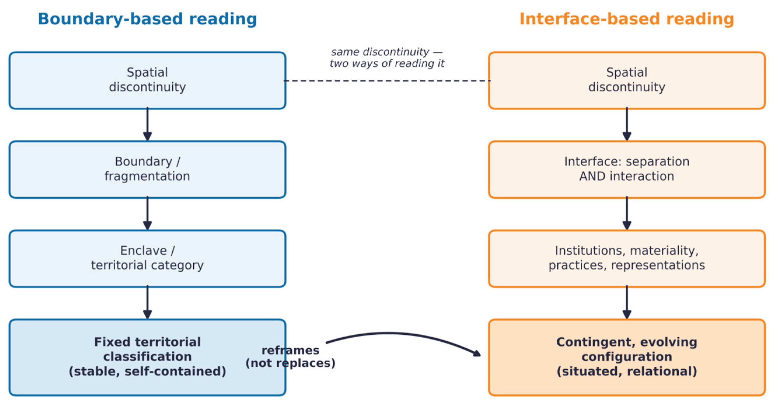
Figure 2.
Conceptual framework for reading socio-spatial interfaces. Source: author's elaboration.
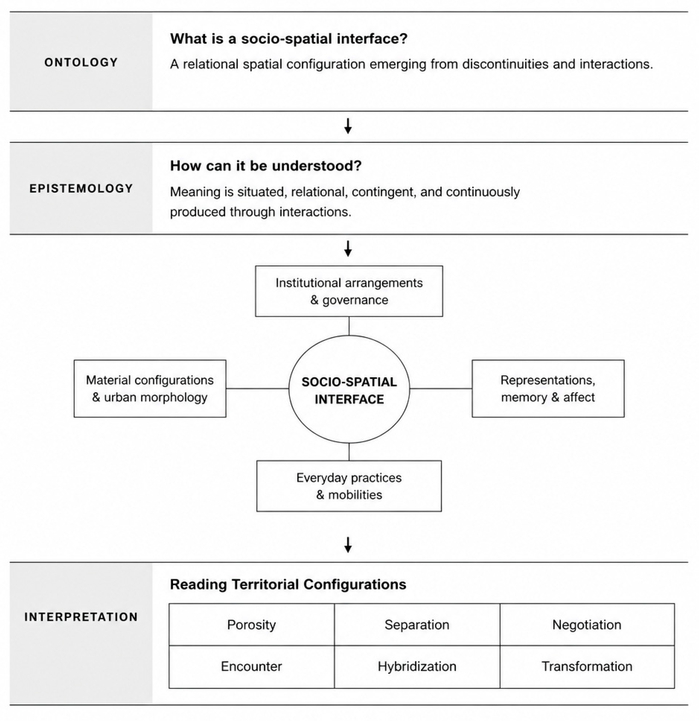
Figure 3.
Schematic reading of interface porosity before and after 2024, by dominant analytical dimension. Source: author's elaboration, based on the fieldwork presented in Section 5 and on subsequent observation of the same corridor.
Figure 3.
Schematic reading of interface porosity before and after 2024, by dominant analytical dimension. Source: author's elaboration, based on the fieldwork presented in Section 5 and on subsequent observation of the same corridor.
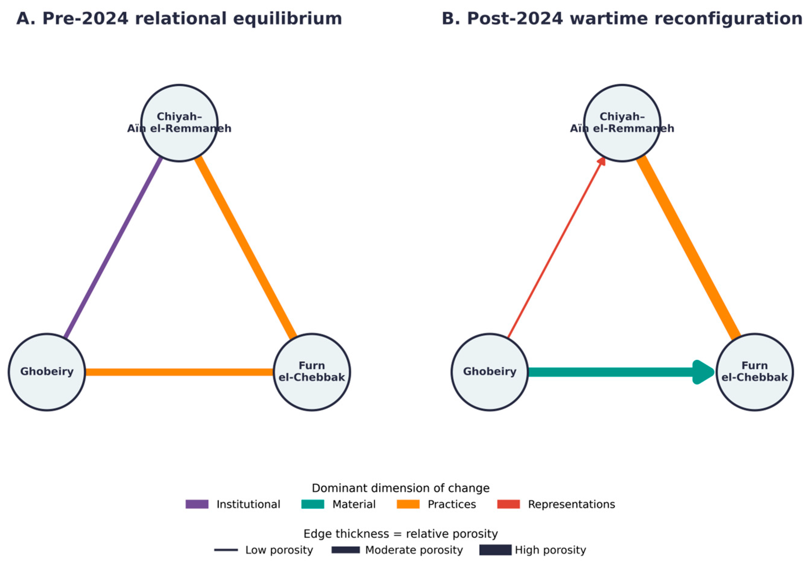

Table 1.
Comparative reading of the three interfaces across the four analytical dimensions.
| Interface | Institutional | Material | Practices | Representations | Main configuration |
|---|---|---|---|---|---|
| Chiyah– Aïn el-Remmaneh | Christian-majority municipalities (86–96%); recurrent intercommunal clashes since Nov. 2019 | Dense communal symbols: crosses, cedar emblems, martyr memorials, religious shrines | High-volume but activity-conditioned crossing; old demarcation line heavily used | 'Sticky place'; security anxiety and demographic surveillance; momentary transgression (Oct. 2019 uprising) | Memory- and security-dominated interface |
| Furn el-Chebbak | Christian-majority municipality (96%); same governance type as Chiyah–Aïn el-Remmaneh | Bilingual/trilingual signage; hybrid café–bar–restaurant sociability spaces | Metropolitan attraction pole for leisure/dining; strong bidirectional shopping flows | Perceived positively by outsiders; itself perceives Ghobeiry with fear and disgust | Commercially hybrid, attraction-based interface |
| Ghobeiry | Hezbollah/Amal political governance; 'contested spaces' territorial logic (Kastrissianakis, 2012) | Inverted political/religious symbols (Amal, Hezbollah); consistently lower commercial prices | Outward-oriented commerce; strong kinship-based visiting (>70% to Tarik el-Jdidé) | Strongly positive self-image; ambivalent toward adjacent Tarik el-Jdidé | Politically distinct interface sustained by commerce and kinship |
Disclaimer/Publisher’s Note: The statements, opinions and data contained in all publications are solely those of the individual author(s) and contributor(s) and not of MDPI and/or the editor(s). MDPI and/or the editor(s) disclaim responsibility for any injury to people or property resulting from any ideas, methods, instructions or products referred to in the content. |
© 2026 by the author. Licensee MDPI, Basel, Switzerland. This article is an open access article distributed under the terms and conditions of the Creative Commons Attribution (CC BY) license.
Copyright: This open access article is published under a Creative Commons CC BY 4.0 license, which permit the free download, distribution, and reuse, provided that the author and preprint are cited in any reuse.