

Submitted:
08 July 2026
Posted:
08 July 2026
You are already at the latest version
Abstract
Segmentation of mining-disturbed land is of great significance for eco-geological environment monitoring. Although existing methods possess strong segmentation capabilities, mining-land exhibits irregular edges, different spatial size, and global texture variability, which lead to difficulties in extracting discriminative features, thereby limiting the accuracy performance. This study first built an RGB-based binary semantic segmentation dataset, covering typical mining-lands in Fujian Province of China. Then a spatial prompt and wavelet Mamba-based multi-scale cross-domain feature fusion network (SWDF-Net) was proposed. (1) Wavelet Mamba-based dual-frequency collaborative enhancement module: high-low frequency information was decoupled by wavelet transform, and further collaboratively enhanced by fusion of multiple local details and Mamba-guided global information. It can highlight mining-lands' high-frequency edge features and low-frequency texture patterns. (2) Cross-domain feature alignment and fusion module: cross-domain statistical calibration and channel conditional modulation were used to narrow spatial-frequency feature distribution gap, which facilitates cross-domain feature alignment and effective fusion. (3) Spatial prompt-based multi-scale feature weighted fusion module: pixel-level weight maps were generated by spatial prior prompt that derived from a spatial decoder and edge gate-based branch, which adaptively fuses former multi-scale dual-domain features. The SWDF-Net achieved best Intersection over Union of 72.22% for mining-land and performed competitively on the ISPRS Vaihingen dataset.
Keywords:
mining land
; spatial prompt
; wavelet transform
; mamba
; remote sensing
; semantic segmentation
1. Introduction
1.1. Background
Mineral reserves play a crucial role in protecting a nation's economic growth and industrial stability. As typical regions affected by intensive human activities, mining areas exhibit spatial distributions and morphological changes that directly reflect ecological degradation and the effectiveness of restoration and remediation efforts [1,2,3]. Therefore, the accurate monitoring of mining-disturbed areas is important for resource management and ecological assessment [4].
With continuous advances in remote-sensing technology, high-resolution satellite imagery has become increasingly accessible, providing reliable data support for monitoring mining areas. Compared to traditional manual interpretation, the remote sensing of geological environments offers advantages such as fine-scale observation, wide-area coverage, and low cost, enabling the dynamic characterization of surface environmental changes in mining-disturbed areas [5]. Existing studies have addressed mining-area interpretation at multiple levels, including pixel-, object-, and scene-level analyses [6]. Early studies were limited by image spatial resolution and computational capacity and mainly focused on pixel- or region-based land-cover recognition. However, with continuous improvements in remote-sensing image resolution, traditional recognition methods have become insufficient for monitoring complex mining scenes [7].
Scene classification can identify only the overall category of an image [8], and object detection localizes targets using bounding boxes [9]. By contrast, semantic segmentation performs pixel-level dense prediction, enabling the accurate delineation of edge details, different spatial sizes, and global textures of mining-disturbed areas. Pixel-level semantic segmentation has become an important technical approach for the accurate identification and dynamic monitoring of mining-disturbed areas [10].
However, mining areas contain complex land cover types, and mining-disturbed areas typically exhibit irregular edges, different spatial sizes, and global texture variabilities [6]. These features usually result in the suboptimal performance of traditional deep learning methods through sparse mining patterns and blurred boundaries. Accurate semantic segmentation can provide reliable technical support for ecological environmental monitoring, resource management, and restoration governance in mining areas [11].
1.2. Related Work and Limitations
Datasets constitute an important foundation for the continuous development of remote sensing semantic segmentation. Existing high-resolution benchmark datasets are mainly designed for urban objects or general land-cover scenarios. For instance, ISPRS Vaihingen and Potsdam focused on buildings, roads, vegetation, and vehicles, whereas LoveDA [12] introduced urban–rural domain discrepancies to support general land-cover semantic segmentation and cross-domain research. Several dedicated datasets have been constructed for different interpretation tasks for remote sensing analysis of mining areas. Zhu et al. [11] constructed the CUG_MISDataset for mining land occupation instance segmentation, Wang et al. [8] developed a multimodal mining scene classification dataset CUG-MLCs, and Li et al. [13] proposed CUG-MSCM for mining-disturbed area classification and mapping. These datasets support mining-area interpretations at the object, scene, and regional mapping levels. However, compared to conventional land-cover datasets, dedicated datasets for the pixel-level semantic segmentation of mining-disturbed areas remain relatively limited.
Deep learning has greatly advanced image segmentation [14]. CNN-based methods have become common tools for interpreting remote sensing images, benefiting from their strong ability to extract spatial semantic features [15,16,17]. Nevertheless, convolution operations are constrained by their restricted receptive range and therefore fail to capture sufficient long-range contextual dependencies. To improve multiscale perception, atrous convolution, pyramid pooling, and multiscale feature modeling have been introduced into segmentation frameworks. For example, Chen et al. [18] proposed the DeepLab series, which enlarges the effective receptive field through atrous convolution and aggregated multiscale contextual information. Zhao et al. [19] developed PSPNet, in which pyramid pooling is adopted to integrate global prior information from regions at multiple scales. Cheng et al. [20] proposed Mask2Former, which uses masked attention to focus on the target regions while maintaining global context modeling. Even though these approaches mitigate the constraint of the receptive field to a certain degree, they still rely mainly on spatial-domain feature modeling. For mining-disturbed areas with complex textures, irregular boundaries, and large-scale variations, purely spatial features are often insufficient to preserve the regional structure and recover edge details simultaneously. On the other hand, the frequency domain is more responsive to textures and edges [20]. Consequently, it is essential to incorporate frequency-domain information into the spatial-domain segmentation networks.
To tackle the drawbacks of relying solely on spatial-domain feature modeling, spatial–frequency collaborative modeling has recently provided a new research perspective on complex remote-sensing scene segmentation. Compared with spatial-domain features, frequency-domain representations can complement image information from another perspective, where high-frequency components are more suitable for characterizing local details such as boundary contours and texture variations, while low-frequency components focus more on preserving the main structure and overall semantic information [21]. Yang et al. [22] employed Haar wavelet decomposition to explicitly decouple high- and low-frequency components and promote spatial–frequency collaboration through a dual-representation alignment mechanism. Li et al. [23] enhanced frequency-domain details by introducing a discrete cosine transform and frequency-enhanced attention. Nam et al. [24] embedded frequency information into attention mechanisms to capture edge details and structural features. These studies show that high-frequency decoupling is effective for separately modeling local details and global structures. This is particularly suitable for mining scenes: high-frequency information helps distinguish mining-disturbed areas from visually similar bare land and buildings, whereas low-frequency information helps maintain the integrity of large and irregular mining regions.
However, frequency decomposition only explicitly separates the feature components and cannot guarantee sufficient modeling of long-range dependencies within low-frequency structural information. Existing studies have shown that visual state space models can achieve large-scale contextual modeling with relatively low computational complexity [25]. VMamba [26] enhances global visual perception through a two-dimensional selective scanning mechanism. Ma et al. [27] further demonstrated that in convolution–Mamba hybrid architectures, the Mamba branch is more suitable for modeling low-frequency information, providing a theoretical basis for introducing Mamba into the low-frequency structural branch. SegMAN [28] also demonstrates the potential of state space modeling for semantic segmentation by capturing the global context while preserving local details. Because mining-disturbed targets are often scattered and structurally associated across space, integrating Mamba with low-frequency branch information is promising for improving global consistency and reducing discontinuous responses.
Spatial- and frequency-domain features differ in their statistical distributions and representational emphasis [29]. Direct concatenation or element-wise addition may fail to fully exploit their complementarity and may even introduce cross-domain interference. To address this issue, Zhang et al. [30] jointly modeled spatial and frequency contextual dependencies using spatial weighting and frequency-weighting modules. Wei et al. [31] proposed a dual-domain fusion framework that incorporates wavelet-based frequency decomposition and fuzzy spatial constraints to improve structural preservation and category discrimination. Fu et al. [32] fused global frequency information, local edge cues, and spatial details to enhance edge and grayscale transition representations. For mining area scenes, spatial-domain features emphasize semantic and shape information, whereas frequency-enhanced features are more sensitive to boundaries, textures, and local structures. Therefore, reducing the distribution shift between the two domains and establishing effective interactions are crucial.
Moreover, the contributions of multiscale features are not fixed, but vary with the target size, edge complexity, and texture distribution [33]. Adaptive multiscale selection and spatial prompt-guided mechanisms showed to enhance the segmentation of complex scenes. He et al. [34] achieved adaptive multiscale contextual modeling through dynamic multiscale filtering. Cheng et al. [35] reweighted local features based on pixel-level semantic predictions to enhance the cross-stage feature specificity. Zhao et al. [36] verified that edge-guided information can assist in target localization and edge recovery. For mining-area scenes, large-scale mining regions rely more on high-level semantics and structural consistency, whereas small-scale disturbed patches and edge-transition regions depend more on shallow textures and edge responses. Therefore, the features at different scales tend to perform different functions [6]. Spatial prior prompts enhanced by the edge branch can not only provide clearer regional location constraints and structural guidance for feature fusion but also strengthen the model’s discriminative capability for key edge regions and main target areas. Therefore, guiding the fusion of multi-scale spatial–frequency features with spatial prior prompts plays an important role in improving the model’s overall segmentation performance.
Mining areas are characterized by complex and highly variable surface morphologies, such as irregular edges, different spatial sizes, and global texture variability, which pose substantial challenges for remote sensing interpretation. At the pixel level, Chen et al. [37] provided a systematic review of land-use and land-cover classification methods for open-pit mining areas, emphasizing the complex spatial patterns and detailed recognition requirements of mining-related land cover. Li et al. [38] conducted multi-modal and multi-model information based on Ziyuan-3 remote sensing images for refined mining landscape classification, whereas Xie et al. [39] introduced DUSegNet to perform pixel-level segmentation of open-pit mining areas using GF-2 remote sensing images. At the object level, Wu et al. [40] proposed a multispectral mining object detection method using class-constraint attention modeling, and Zhu et al. [11] proposed a remote sensing instance segmentation-based method for comprehensive and accurate identification of mining land occupation. At the scene level, Liu et al. [41] proposed a deep and shallow feature-fusion approach for identifying open-pit coal mine areas in remote-sensing images. Li et al. [13] developed an edge-enhanced dynamic graph convolutional network to classify and map mining-disturbed areas. Fan et al. [42] integrated multisource data and proposed a global–local dual-stream collaborative representation network to improve complex mining scene classification. Overall, existing studies on mining area remote sensing have made preliminary progress in multiple directions and have gradually established a foundation in terms of both datasets and methods. However, research specifically focusing on pixel-level semantic segmentation of mining-disturbed areas remains limited. Therefore, constructing a dedicated semantic segmentation dataset for mining-disturbed areas and designing segmentation methods that are well adapted to their scene characteristics are of significant research importance.
1.3. Motivation
A review of the existing literature indicates that the accurate segmentation of mining-disturbed areas faces numerous limitations. Specifically, related datasets and methods still need to be further improved in the following aspects:
- Develop comprehensive and publicly available semantic segmentation datasets dedicated to mining-disturbed areas to support the training, evaluation, and comparison of specialized segmentation models for mining-area scenes.
- Accurately characterize the inherently irregular edges and global texture variability of land-cover objects in mining-disturbed areas, which remains difficult for standard convolutional networks owing to their limited local receptive fields.
- Achieve efficient alignment between spatial and frequency features, effectively narrow the distribution shift between the two feature domains, and establish a closer and more robust cross-domain interaction mechanism.
- Incorporate dynamic selection and adaptive aggregation of multiscale features to flexibly address practical challenges such as different spatial sizes among mining targets and inconsistent contributions of features at different levels.
These discrepancies in present research prompt this study to establish a new network architecture and dedicated dataset for advancing semantic segmentation research on mining-disturbed areas.
1.4. Contributions
To handle these limitations, this study constructs a CUG-FJMine dataset and proposes a spatial prompt and wavelet Mamba-based multi-scale cross-domain feature fusion network (SWDF-Net). The key findings of this research are stated as follows:
- CUG-FJMine is constructed as a high-resolution remote sensing semantic segmentation dataset covering typical mining areas in Fujian Province. It aims to alleviate the shortage of dedicated semantic segmentation datasets for mining-disturbed areas and provide data support for the pixel-level interpretation of mining scenes.
- A wavelet Mamba-based dual-frequency collaborative enhancement module (WMFE) is constructed to explicitly decouple high- and low-frequency components through wavelet transformation and to achieve collaborative enhancement of dual-frequency features by integrating multiple local detail enhancements with Mamba-guided global information modeling, thereby effectively improving the modeling capability for irregular edges, global texture variability, and long-range contextual dependencies among spatially discrete mining patches.
- A more robust cross-domain feature alignment and fusion module (DFAF) is introduced to reduce the distribution discrepancy between the spatial- and frequency-domain features, thereby promoting the precise alignment and effective fusion of cross-domain features.
- A spatial prompt-based multiscale feature-weighted fusion (PMFF) module is proposed. By leveraging spatial prior prompts to guide the dynamic weighted fusion of features at different scales, PMFF adapts to the different spatial size characteristics of mining-disturbed regions and improves the complete representation and segmentation capability of multiscale targets.
The following sections are arranged as follows: Section 2 describes the CUG-FJMine dataset utilized in our research, Section 3 presents the structure of the SWDF-Net, Section 4 reports the experimental conditions and outcomes, Section 5 evaluates the efficiency of the proposed modules and shows a visual comparison of model results, and Section 6 provides the conclusion and possible future extensions.
2. Datasets
This section introduces CUG-FJMine, the constructed RGB binary semantic segmentation dataset covering typical mining areas in Fujian Province, and the public Vaihingen dataset. Using these datasets, the extensive applicability and consistency of the proposed method with the current advanced techniques are ensured.
2.1. CUG-FJMine Dataset
2.1.1. Study Area and Remote Sensing Data Sources
The study area is situated in Fujian Province, China, a province in the southeastern coastal region of China. The study area extends from 115°50′E to 120°40′E and from 23°33′N to 28°20′N. Fujian Province is rich in mineral resources, with more than 80 identified mineral types, and exhibits typical characteristics of surface mining-disturbed areas. Figure 1 depicts the position of the study area and its corresponding true-color imagery.
In this study, GF-6 satellite imagery was selected as the primary source of remote sensing data. The RGB information was extracted from GF-6 satellite images. Orthorectification was first carried out on the panchromatic and multispectral datasets acquired by the GF-6 satellite, followed by geometric registration of the multispectral data. The processed datasets were then integrated to obtain 2-m-resolution three-band RGB optical images.
2.1.2. Dataset Construction and Description
The mining land-cover objects in the study area were first manually interpreted through visual interpretation. Following the common data organization strategy in remote sensing semantic segmentation, the imagery was cropped into non-overlapping 256 × 256 pixel patches in left-to-right and top-to-bottom order. This patch size preserves local textures and edge details while balancing the effective receptive field and GPU memory consumption and has also been adopted in public benchmark datasets such as MultiSenGE [43]. Considering the scattered distribution of mining targets, the generated patches were further filtered, and only patches containing mining targets were retained to improve sample validity and training efficiency.
The high-resolution RGB remote sensing mining-area segmentation dataset constructed in this study contained 7,153 remote sensing images, each consisting of three bands and covering two land-cover categories: mining areas and non-mining areas. A 7:2:1 split was adopted to construct the training, validation, and test sets, and the corresponding spatial distribution of the mining patches and dataset samples in Fujian Province is shown in Figure 2. To avoid data leakage caused by the partitioning of large mining areas, all image patches extracted from the same mining area were assigned to the same data subset, whereas samples from different mining areas were randomly divided.
Figure 3 shows representative samples of different mining subcategories in CUG-FJMine. Mining-disturbed areas include multiple subtypes such as open-pit mines, waste rock dumps, beneficiation plants, transfer points, mining roads, and associated buildings. These subtypes differ significantly in their spectral response, texture, structure, geometric shape, and spatial scale, leading to strong intraclass variability. Mining-related objects often exhibit similar spectral and textural characteristics to natural bare land, mountain roads, and ordinary building areas, resulting in blurred class boundaries and small interclass differences. Their composite distributions and nested spatial patterns further increase the difficulty of segmentation.
A quantitative analysis of mining-area proportions was also conducted. As shown in Figure 4, samples with mining-area proportions of 0–10% accounted for more than two-thirds of all images, indicating that mining targets generally exhibited small objects and sparse distribution characteristics. As the proportion of mining area increased, the number of samples decreased rapidly, and images with proportions greater than 40% accounted for only a small fraction. Overall, CUG-FJMine presented a clear long-tail characteristic, reflecting an imbalance between mining areas and background land-cover objects in real remote sensing scenes.
2.2. Vaihingen Dataset
The Vaihingen dataset consisted of 33 orthophotos acquired over the Vaihingen area in Germany. The image sizes were not completely consistent, with an average size of approximately 2500 × 2000 pixels with a ground resolution of 9 cm. Each sample contained three spectral bands, namely near-infrared, red, and green, as well as the corresponding Digital Surface Model (DSM) and Normalized Digital Surface Model (NDSM) information. The annotations covered six semantic categories: impervious surfaces, buildings, low vegetation, trees, cars, and clutter/background. To maintain consistency with previous studies, we followed the standard protocol provided by the open-source remote-sensing segmentation framework GeoSeg [44] for dataset partitioning.
3. Methods
3.1. Overall Network Architecture
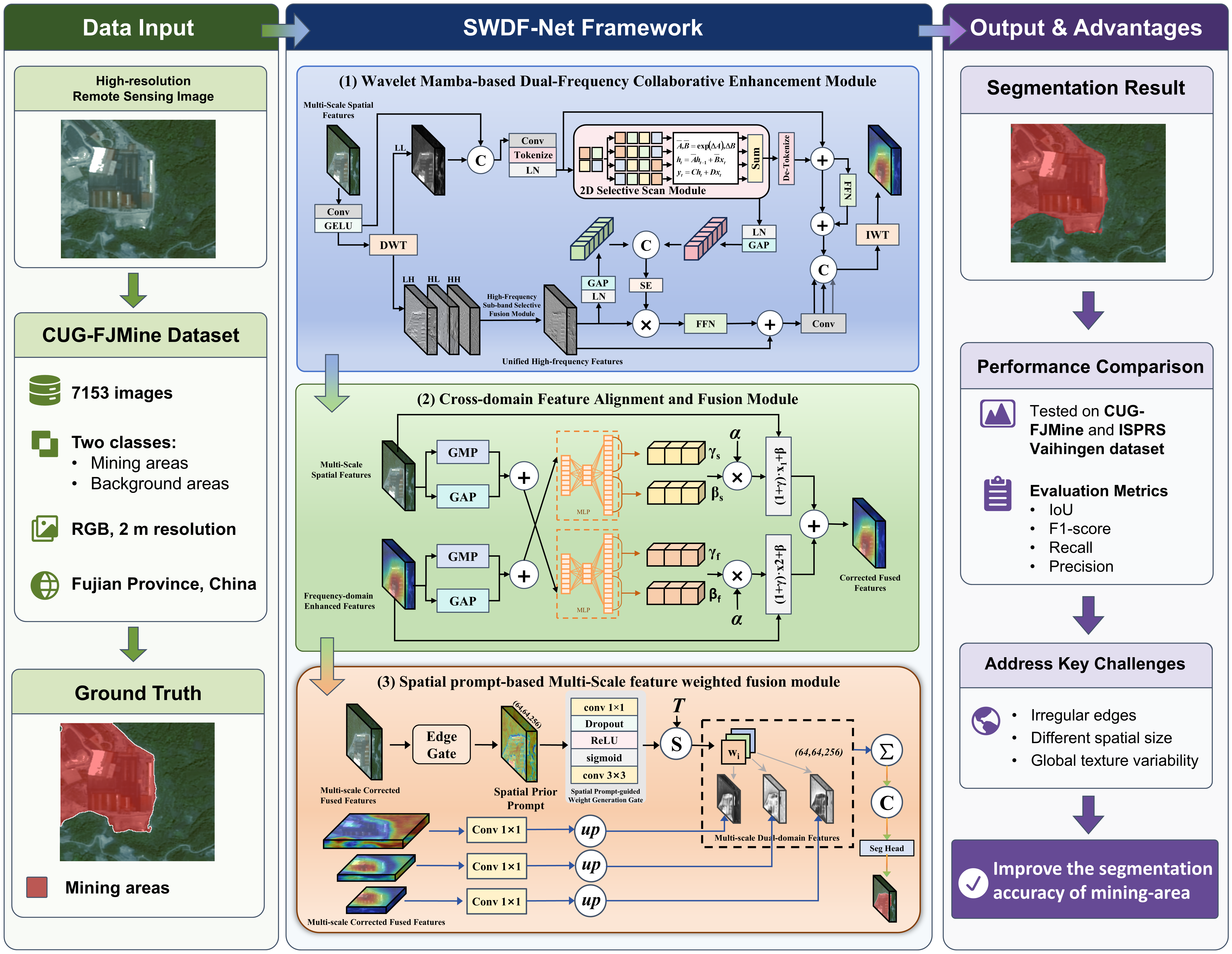
Figure 5 illustrates the overall framework of SWDF-Net, which is designed based on an encoder–decoder architecture. The encoder adopts a pretrained ConvNeXtV2-Tiny [45] as the backbone for multiscale semantic feature extraction. As a lightweight convolutional backbone, ConvNeXtV2-Tiny consists of four sequential stages built with ConvNeXt Blocks. At each stage, the feature map is downsampled by a factor of two, thereby generating semantic representations with gradually reduced spatial resolutions. The four output feature maps have channel dimensions of 96, 192, 384, and 768, respectively. The decoder is built upon UPer Head [46], which fuses four-level features in a top-down manner to obtain spatial semantic features at the output resolution.
To compensate for the deficiency of spatial-domain features in capturing textural details and delineating boundaries, SWDF-Net introduces a frequency-domain branch on the last three scale features of the encoder. Taking multiscale features as input, the WMFE first enhances the frequency-domain representations by explicitly decoupling and collaboratively modeling high- and low-frequency information. Subsequently, the DFAF aligns and fuses spatial-domain and frequency-enhanced features at the same scale through cross-domain statistical calibration and conditional modulation. Finally, the PMFF adaptively aggregates the calibrated multiscale features under the guidance of spatial prompts and edge-aware information. The resulting frequency-domain complementary feature is concatenated with the spatial semantic feature and fed into the segmentation head to generate a final prediction.
3.2. Wavelet Mamba-Based Dual-Frequency Collaborative Enhancement Module
This module aims to address challenges such as irregular land-cover shapes and scattered target distributions of targets in mining-disturbed areas through the collaborative design of frequency-domain detail enhancement and Mamba-based global modeling. The motivation lies in the fact that wavelet-based frequency decomposition can effectively separate structural information from detailed information in mining scenes. Specifically, the low-frequency sub-band LL mainly preserves the large-scale morphological and structural trends of mining areas, such as pit contours and waste dump layouts, whereas the directional high-frequency sub-bands HL, LH, and HH focus on information such as edge textures, including mining-area edges and strip-like road textures. However, because low-frequency structural components and high-frequency textural components play markedly different roles in mining area recognition, a simple unified modeling strategy often struggles to maintain global semantic consistency and local edge clarity simultaneously. Motivated by this consideration, this study designs the WMFE, whose overall structure is presented in Figure 6.
The WMFE explicitly decouples structural and detailed feature information through a local and reversible wavelet transform and processes them separately. In the low-frequency branch, Mamba state-space modeling was introduced to learn long-range structural dependencies, enabling better global perception of large-scale structural patterns and sparse target distributions. In the high-frequency branch, Mamba-guided global low-frequency information is used to perform gated modulation on local high-frequency details, generating frequency-enhanced features that are better suited for mining-edge interpretation, and reducing the risk of confusion between mining-disturbed areas and natural backgrounds.
Let the spatial feature at the current scale be denoted as , where C refers to the channel dimension, and H and W refer to the spatial height and width of the feature map, respectively. The WMFE consists of the following four steps.
3.2.1. Wavelet-Based Dual-frequency Decoupling
To suppress noise responses and aggregate local neighborhood information, a lightweight mapping implemented with a 3 × 3 convolution followed by GELU activation is first applied to locally re-encode the spatial feature at the current scale, yielding an intermediate feature .
where denotes a lightweight local mapping implemented with a 3 × 3 convolution followed by GELU activation.
Subsequently, a two-dimensional discrete wavelet transform (DWT) is performed on F to perform reversible frequency decoupling along the spatial dimensions, yielding one low-frequency sub-band LL and three high-frequency sub-bands, namely LH, HL, and HH:
3.2.2. Low-Frequency Mamba State-Space Structural Modeling
The low-frequency sub-band LL is fed into the low-frequency branch, whereas the downsampled intermediate feature is introduced as a complementary component. The downsampled intermediate feature and LL are first integrated by channel-wise concatenation, and a subsequent 3 × 3 convolution is employed to merge local representations and adjust the channel distribution, producing the low-frequency fused feature L0. Furthermore, L0 is tokenized and then processed with layer normalization to generate the intermediate feature Z as the input to SS2D:
where denotes channel-wise concatenation, denotes the tokenization operation, denotes 2× downsampling, and denotes layer normalization.
Subsequently, Z is fed into SS2D for global state-space modeling and is updated through a residual connection. It is then passed through a convolutional feedforward network (ConvFFN) for local nonlinear transformation, and the low-frequency enhanced feature is obtained through a second residual connection:
where denotes the operation that restores the token sequence to a spatial feature map, and represents the low-frequency structural feature enhanced by Mamba-based global modeling and local nonlinear transformation.
SS2D[26] is a Mamba-based two-dimensional selective state-space modeling module. It unfolds the two-dimensional feature map into multiple scanning sequences along different spatial directions, captures long-range dependencies through discrete state-space equations, and fuses directional outputs to obtain features with both a global receptive field and directional sensitivity.
3.2.3. High-Frequency Gated Detail Fusion
The high-frequency branch first performs selective multi sub-band fusion through High-Frequency Sub-band Selective Fusion Module (HFSFM). After the three high-frequency sub-bands are aggregated, a global descriptor is extracted through global average pooling (GAP). An MLP is then used to predict the importance weights of different sub-bands. These weights are normalized by Softmax along the sub-band dimension and used for weighted summation, yielding a unified high-frequency feature representation, .
To better align the high-frequency details with the real structures of the mining areas and suppress noise interference, the low-frequency enhanced feature is used to gate and modulate the high-frequency feature . Specifically, and the Mamba-guided low-frequency enhanced feature are first processed by layer normalization, and channel-level statistics are extracted through GAP. The resulting descriptors combined and submitted to an SE block to generate adaptive gating vectors. Subsequently, the gating vector is used to precisely modulate in a channel-wise manner, enabling low-frequency semantics to guide the selection of effective high-frequency information and specifically suppress pseudo-high-frequency responses caused by shadow boundaries. Finally, the high-frequency branch performs local nonlinear refinement using GConvFFN and obtains the high-frequency enhanced feature via a residual connection.
where denotes element-wise modulation.
3.2.4. Inverse Wavelet Feature Reconstruction
WMFE maps the high-frequency enhanced feature back into three-directional high-frequency sub-bands, concatenates them with the low-frequency enhanced feature along the channel dimension, and then performs reversible reconstruction through the inverse discrete wavelet transform (IWT). In this way, structural consistency and mining- edge details are synchronously injected back into the spatial-domain feature representation, ultimately yielding the frequency-enhanced feature with the same resolution as the input.
where denotes the high-frequency sub-band restoration mapping for reconstructing three directional high-frequency sub-bands from the unified high-frequency enhanced feature .
3.3. Cross-Domain Feature Alignment and Fusion Module
This module aims to align the spatial-frequency features for stable fusion between the spatial-domain and frequency-enhanced features. The motivation for this is that the two feature types exhibit evident cross-domain shifts in the response distributions and channel statistics, and direct fusion may cause unstable interactions, imbalanced representations, and limited fusion effectiveness. To cope with this problem, DFAF was introduced. As shown in Figure 4, DFAF extracts global descriptors through dual-pooling channel summarization, adopts cross-domain conditional generation, and performs FiLM-style channel correction to adaptively align feature distributions and achieve effective spatial-frequency collaborative fusion.
3.3.1. Dual-Pooling Channel Descriptor
First, GAP and global max pooling (GMP) are applied to both the spatial-domain feature and the frequency-enhanced feature , and their outputs are added to obtain compact channel-level global descriptors. Among them, GAP emphasizes the global response intensity, whereas GMP highlights salient activation regions, thereby improving the robustness of the model in representing channel distributions under small-sample and illumination-perturbation conditions.
3.3.2. Cross-Domain Conditional Generation
Subsequently, the module adopts a cross-generational strategy. For the spatial branch, the frequency-domain descriptor is used as the conditional input and fed into an MLP to generate the scaling term and bias term for the spatial domain. Similarly, for the frequency branch, the spatial-domain descriptor is used as the conditional input and fed into an MLP to generate the scaling term and bias term for the frequency domain.
This bidirectional parameter correction mechanism constrains the channel statistics of each domain using global information from the other domains, thereby fundamentally alleviating cross-domain distribution discrepancies.
3.3.3. FiLM-Style Channel Calibration and Fusion
To avoid feature drift caused by excessive calibration, a learnable coefficient αis introduced to control the calibration intensity. FiLM-style affine modulation is adopted to perform channel alignment on the two feature streams, yielding the calibrated spatial-domain feature and frequency-enhanced feature . Calibrated features and are then added pixel-by-pixel to obtain the calibrated fused feature .
where denotes channel-wise multiplication, and are broadcast along the spatial dimensions.
3.4..Spatial Prompt-Based Multi-Scale Feature Weighted Fusion Module
This module aims to adaptively select and aggregate calibrated features at different scales to address significant scale variations in land-cover objects and the uneven distribution of local textures in mining-disturbed areas. The motivation is that multiscale features contribute differently to edge delineation, local texture representation, and high-level semantic expression; however, fixed fusion strategies often struggle to accommodate the size variations and spatial structural differences of mining targets. The spatial prompts provided by the spatial branch provide discriminative structural priors and positional guidance for feature fusion. Accordingly, we designed a PMFF, as shown in Figure 4. The PMFF treats multiscale features as complementary candidate branches and generates pixel-level weight maps using a spatial prompt-driven gating network, thereby enabling adaptive cross-scale feature fusion.
3.4.1. Channel Unification and Spatial Alignment of Scale Features
The multi-scale calibrated fused feature output from DFAF from the i-th encoding stage is denoted as , where . Because features from different stages vary in channel number and spatial resolution, each stage feature is first aligned in the channel dimension using a 1 × 1 convolution and then resized through upsampling to obtain the scale-aligned candidate multiscale features:
where denotes the candidate multi-scale feature after alignment at the i-th scale, and denotes the bilinear interpolation upsampling operation.
3.4.2. Spatial Prompt-Guided Dynamic Multi-Scale Weight Generation
Next, PMFF introduces the Spatial Prompt-guided Weight Generation Gate (SPW-Gate) to generate dynamic scale weights. Let the prompt feature output by the spatial decoder be denoted as R. R is fed into SPW-Gate, which consists of a 3 × 3 convolution, batch normalization (BN), ReLU, Dropout, and a 1 × 1 convolution. This gate learns the dependency between the prompt and multiscale features and generates the raw weight score Si for each scale:
where denotes the raw weight scores corresponding to the three scale features.
Subsequently, a Softmax function with a temperature coefficient T is adopted to normalize these scores, yielding dynamic weight maps for the features at different scales:
where denotes the weight of the i-th scale candidate feature at spatial position . The temperature coefficient Tis is used to adjust competition intensity at different scales.
3.4.3. Multi-Scale Dynamic Weighted Fusion
After obtaining the dynamic weight maps for the features at different scales, the PMFF performs weighted fusion on the aligned features from the three scales, yielding a final multiscale fused representation.
Subsequently, according to the structure shown in Figure 4(d), the spatial prompt feature R is first added element-wise to the spatial domain feature output by UPerHead to obtain an enhanced spatial domain representation, thereby further injecting structural priors and edge guidance provided by the spatial decoding branch. The enhanced spatial feature is then concatenated with the fused multiscale representation through channel-wise fusion to obtain the final output feature.
4. Results
4.1. Experimental Settings
The experimental environment was configured with the Windows 10 operating system, and semantic segmentation algorithms were implemented based on the PyTorch framework. The hardware configuration included 64 GB of RAM, an AMD EPYC processor and a 514 GB NVIDIA RTX A5000 GPU with 24 GB of memory.
Before the experiments, the mining image samples were uniformly standardized. Network training was performed using the AdamW optimizer [47], with an initial learning rate of 5 × 10⁻⁵ and the batch size set to 4. The model was trained for 56,000 iterations with validation conducted every 4,000 iterations. The performance indicators of the proposed model was obtained from the final results after training, and the comparison models were independently reproduced based on their optimal parameter configurations.
To thoroughly and fairly assess the model performance, the intersection over union (IoU), F1-score, recall, and precision were calculated for the mining class on the CUG-FJMine test set. The Vaihingen test set, overall accuracy (OA), mean intersection over union (mIoU), and mean F1-score (mF1-score) were computed using the Vaihingen test set. In addition, class-wise F1-scores were reported to further compare the classification capability of different models on the Vaihingen dataset.
4.2. Comparative Experiments
To establish comparable experimental baselines, the proposed model was evaluated against several representative semantic segmentation methods on the CUG-FJMine and Vaihingen datasets, including classical models such as U-Net, UNetFormer, ConvNeXtV2, HD-Net, SegViT, and CMTFNet, as well as Mamba-based models including RS3Mamba and UMFormer, and frequency-domain modeling-based models including SFFNet and AFENet.
4.2.1. Results on the CUG-FJMine Dataset
The quantitative comparison of different methods for mining classes on the CUG-FJMine dataset is reported in Table 1. The experimental results demonstrated that the proposed SWDF-Net achieved the best overall performance in a mining-class segmentation task. Specifically, the IoU reached 72.22%, which exceeds the second-ranked method by 2.95%. The F1-score reached 83.87%, exceeding that of the second-best model by 2.03 percentage points. SWDF-Net outperformed all the compared methods on both core evaluation metrics, namely, IoU and F1-score. In addition, SWDF-Net obtained Recall and Precision scores of 83.35% and 84.39%, respectively, ranking second among all methods. This indicates that the proposed method is capable of accurately identifying mining areas while preserving high segmentation completeness and suppressing false detections. These results verify the effectiveness of the proposed model on the CUG-FJMine dataset.
The methods depending entirely on spatial domain modeling, such as CNN-based approaches, achieved relatively lower segmentation accuracy. The metrics of U-Net, ConvNeXtV2, HD-Net, and UNetFormer were inferior to those of the proposed method. Although UNetFormer and ConvNeXtV2 improved over traditional convolutional networks, with IoU values of 66.78% and 69.27%, respectively, they remained limited in capturing large-scale contextual relationships and distinguishing visually similar regions. Mamba-based methods exhibited a stronger global modeling ability. For example, RS3Mamba achieved the highest recall of 83.63%, whereas UMFormer obtained an IoU of 65.95% and an F1-score of 79.48%. However, their mining-class metrics were still lower than those of SWDF-Net, suggesting that global dependency modeling alone is insufficient for recovering local texture details and boundaries in complex mining scenes.
Frequency-domain methods such as SFFNet and AFENet achieved IoU values of 67.58% and 63.86% and F1-scores of 80.66% and 77.94 %, respectively. Although frequency-domain information improves these methods to some extent, their overall performance still lags behind SWDF-Net. This advantage stems from the collaborative representation and innovative fusion of spatial-frequency information in this study, as well as the introduction of the Mamba structure into frequency-domain modeling to enhance the long-range modeling capability. This joint modeling strategy can more effectively distinguish mining areas with similar backgrounds, such as bare land, construction sites, and cement surfaces than individual methods, thereby achieving superior segmentation results.
4.2.2. Results on the ISPRS Vaihingen Dataset
To assess the generalization capability of SWDF-Net across different scenes and spatial resolutions, experiments were conducted using the ISPRS Vaihingen dataset. As shown in Table 2, SWDF-Net achieved the best mF1 and mIoU values, reaching 92.09% and 85.54%, respectively, and the second-best OA of 91.96%. These findings verify the effectiveness of SWDF-Net in mining scenes and further reveal its strong feature modeling and scene generalization capabilities in high-resolution urban scenarios.
Similarly, the evaluation results on the CUG-FJMine dataset suggest that methods relying solely on convolutional neural networks or transformers obtained relatively low segmentation accuracy, with U-Net, SegViT, UNetFormer, CMTFNet, and ConvNeXtV2 performing worse than the proposed method across all metrics. RS3Mamba and UMFormer, which incorporate the Mamba concept, effectively enhanced long-range dependency modeling. Among them, UMFormer achieved an OA of 93.00% and RS3Mamba achieved a high accuracy of 96.82% for the building class. However, their mIoU values were 83.30% and 82.78%, respectively, which were also less than those of SWDF-Net. This indicates that relying solely on enhanced global relationship modeling in the spatial domain is insufficient for characterizing complex boundaries and easily confused regions. As representative methods that introduce frequency-domain information, SFFNet and AFENet achieved mIoU values of 84.80% and 84.55%, respectively, showing strong competitiveness; however, they did not reach the 85.54% performance of the proposed method. These findings show that the spatial-frequency collaborative modeling and adaptive fusion strategy adopted in this study can integrate spatial structural and frequency-detail information more effectively, thereby achieving a more balanced and robust segmentation performance across multiple categories, including buildings, low vegetation, trees, and cars.
From the class-wise metrics, SWDF-Net achieved F1-scores of 86.28% and 92.13% for the low-vegetation and tree classes, respectively, both of which were the best results among all methods. For the building class, it reached 96.80%, which was on par with the best result. This result demonstrates the stronger ability of the proposed method to distinguish land-cover categories characterized by fine textures, complex boundaries, and susceptibility to background interference.
4.3. Visual Comparative Analysis
4.3.1. Visual Comparative Analysis on the CUG-FJMine Dataset
To further compare the performances of the different methods, Figure 7 presents the visual segmentation results under five typical mining scenarios. The columns show the original images, ground-truth annotations (GT), baseline results, comparative methods, and results of SWDF-Net.
Overall, Baseline and UNet produced relatively coarse results and were prone to misclassification and local omissions, especially in complex backgrounds and large-scale mining regions. HDNet, UNetFormer, and AFENet improved the extraction of the main mining areas, but suffered from unsmooth boundaries, local adhesion, and fragmented omissions. UMFormer, RS3Mamba, and SFFNet showed better continuity in large-area structures; however, they still exhibited mis-segmentation or insufficient detail recovery in edge-transition regions, bright exposed surfaces, and sparsely distributed small patches. In contrast, SWDF-Net generated results closer to the GT across all five samples. It recovers spatial coverage of the mining regions and more accurately delineated the edge contours and discrete small targets, demonstrating a stronger segmentation performance under complex background interference.
4.3.2. Visual Comparative Analysis on the Vaihingen Dataset
Figure 8 shows the visual segmentation results of the SWDF-Net and several competitive methods under the four representative scenarios. Overall, Baseline and AFENet produced relatively coarse results with edge blurring and local misclassification at the category junctions. UMFormer and RS3Mamba improved the continuity of large-scale buildings and road structures but still suffered from category confusion and detail loss in locally complex regions. SFFNet performed well in main-region extraction and edge delineation; however, mis-segmentation remained in small objects and areas with strong texture variations.
In contrast, SWDF-Net recovered object contours more accurately and better distinguished subtle differences between adjacent categories, especially around tree–low vegetation, impervious surface boundaries, building edges, and small vehicles. These results indicate that the proposed spatial-frequency collaborative modeling and adaptive fusion mechanism effectively strengthens feature representation and category discrimination, leading to more precise and consistent segmentation across various scenarios.
5. Discussion
5.1. Ablation Experiments
Ablation experiments were performed on the CUG-FJMine dataset to investigate the role of each component in SWDF-Net. As listed in Table 3, SWDF-Net consists of three core modules: WMFE, DFAF, and PMFF. ConvNeXtV2 was used as the baseline model (Model 1) and different module combinations were introduced for comparison. To assess the independent effect of each module, WMFE was replaced with an identity wavelet transform to remove frequency-domain modeling, DFAF was replaced with pixel-wise addition to eliminate dynamic calibration, and PMFF was evaluated by removing the feature enhancement process.
The results in Table 3 show that Models 2, 3, and 4 outperformed the baseline, demonstrating the effectiveness of WMFE, DFAF, and PMFF. Compared with the baseline model, Model 2 with WMFE obtained clear improvements across multiple metrics, with the IoU increasing from 69.27% to 71.37% and the F1-score increasing from 81.84% to 83.29%. This demonstrates that introducing the WMFE can effectively capture detailed frequency-domain information, thereby significantly improving the overall segmentation accuracy. In comparison, Model 3 with DFAF alone also achieved considerable performance gains, yielding an IoU of 71.01% and an F1-score of 83.05%. This indicates that the DFAF improves the discriminatory ability of mining areas through adaptive calibration while suppressing certain redundant responses. Compared with WMFE and DFAF, the individual gain achieved by PMFF is relatively small, suggesting that its effectiveness depends, to some extent, on the high-quality features provided by the preceding modules.
The two-module combination further verified the complementarity of the proposed components. Models 5, 6, and 7 improved over their corresponding single-module variants, showing that frequency-domain modeling, cross-domain calibration, and multiscale refinement collaborate at different levels, including feature representation, semantic alignment, and edge recovery. Among them, Model 7, combining WMFE and DFAF, achieved the best two-module performance, reaching an IoU of 71.86% and F1-score of 83.63%. This confirms that the DFAF can further align and calibrate the frequency-enhanced features produced by the WMFE.
When all three modules were introduced simultaneously, the complete SWDF-Net model (Model 8) achieved the best overall performance, with the IoU, F1-score, Recall, and Precision reaching 72.22%, 83.87%, 83.35%, and 84.39%, respectively. Taking the baseline model as a reference, SWDF-Net improved the IoU and F1-score by 2.95% and 2.03%, respectively. Further comparison of Models 5 to 8 shows that introducing the remaining module based on different two-module combinations consistently improves the model performance. This indicates that the three core components exhibited good complementarity and synergy, ultimately enabling SWDF-Net to achieve the best performance in the mining-area segmentation task.
Figure 9 presents a qualitative comparison of the segmentation results for various ablation combinations across five representative mining scenarios. Both the quantitative results and qualitative visual analysis demonstrate that the design of each module jointly contributes to a substantial improvement in model performance.
To enhance the interpretability of the ablation analysis, this study adopted Gradient-weighted Class Activation Mapping (Grad-CAM) [56] to visualize the feature responses of different layers in the SWDF-Net. As shown in Figure 10, three representative samples used in the ablation experiments from the CUG-FJMine dataset are selected to represent the response regions of the complete model in Layer2, Layer3, and Layer4. Layer2 mainly focuses on global texture variability, edges, and local detail information with relatively dispersed responses. Layer3 gradually begins to focus on the main mining areas and their edge regions, while the background interference is reduced. The high-response regions in Layer4 are the most concentrated and show better spatial correspondence with the GT regions, indicating that deeper features possess a stronger semantic representation capability.
Combined with the ablation results in Table 3, WMFE enhances the perception of mining boundaries, local textures, and structures by introducing frequency-domain modeling, whereas Mamba-based long-range dependency modeling helps capture semantic associations among sparse targets, such as small mining objects and strip-like roads. The DFAF further aligns and calibrates the spatial-frequency features, suppresses redundant background responses, and improves the discrimination of mining regions. The PMFF strengthens the continuous response of deep features through multiscale feature enhancement and fusion, enabling a more complete representation of the mining areas. Consequently, the model could form more concentrated and stable high-response regions in complex scenes. The heatmap results verified the complementarity and synergy among the three core modules from the perspective of feature responses, providing a more intuitive explanation for the performance improvement of SWDF-Net.
5.2. Analysis of Class Confusion in Complex Scenes
The proposed SWDF-Net achieved favorable overall performance in the mining-area segmentation task. However, certain omission errors occur in complex mining scenes.
As illustrated in Figure 11, the manual annotation mainly covered a relatively large mining-disturbed region on the left side, whereas the model prediction identified only part of the target area. Some mining areas on the left side were not completely detected, indicating that the model still suffered from incomplete region extraction when dealing with mining targets characterized by irregular edges and texture variability.
he visual result also shows that the model identifies a potential mining area on the right side, which is not labeled in the manual annotation. This region exhibited texture patterns similar to those of the surrounding mining areas. Although this region would be counted as a false positive under the current annotation, from the perspective of visual image characteristics, this prediction also indicates that SWDF-Net has can capture potential mining-related features.
6. Conclusions
The semantic segmentation of mining areas is of great significance for mineral resource supervision and ecological environmental assessment. To fill the gap in remote sensing segmentation datasets for mining scenarios, this study constructed a semantic segmentation dataset for typical mining areas, named CUG-FJMine.
To deal with the challenges of mining land-cover segmentation, this study proposes the SWDF-Net. WMFE was designed to improve the modeling of irregular edges and global texture variability in mining areas. By explicitly decoupling low-frequency structural information and high-frequency textural details and further integrating Mamba state-space modeling with a gated modulation mechanism, the WMFE improves the capability of the model to represent mining-area edges and structures. Meanwhile, the DFAF was proposed to alleviate the response distribution discrepancy between the spatial- and frequency-domain features, thereby improving the stability and effectiveness of spatial-frequency fusion. In addition, the PMFF was designed to adaptively select and aggregate frequency-domain features at different scales using pixel-level weight maps generated from spatial prior prompts, further enhancing the capability of the model to represent complex textured regions and different spatial sizes.
The results obtained from the CUG-FJMine and ISPRS Vaihingen datasets demonstrate that the proposed SWDF-Net surpasses various comparison methods in terms of segmentation accuracy and overall robustness, significantly improving segmentation precision and edge clarity in complex scenes. However, the present method is dependent on a single optical remote sensing imagery and has not yet fully exploited the complementary information provided by multimodal data. Therefore, its discriminative capability in complex scenarios remains limited. In future work, we will further expand the mining-area semantic segmentation dataset and construct related task datasets, such as multi-label scene classification and mining-object detection datasets. We also explore multimodal and multitasking learning frameworks. By sharing feature representations and supervisory information, the model’s understanding of complex mining scenes can be enhanced further, thereby reducing false detections and improving the robustness of the segmentation results.
Author Contributions
Conceptualization, J.S. and X.L.; methodology, J.S.; software, J.S.; validation, J.S., J.W., Y.Q., Z.L. and J.F.; formal analysis, J.S., J.W. and Z.L.; investigation, J.S., J.W., Y.Q., Z.L. and J.F.; resources, Y.Q. and X.L.; data curation, J.S., J.W. and Z.L.; writing—original draft preparation, J.S.; writing—review and editing, J.S., J.W., Y.Q. and X.L.; visualization, J.S.; supervision, Y.Q., J.F., J.W. and X.L.; project administration, J.W., Y.Q., J.F. and X.L.; funding acquisition, X.L. All authors have read and agreed to the published version of the manuscript.
Funding
This study was supported by the Natural Science Foundation of China under Grant 42071430.
Data Availability Statement
The raw data supporting the conclusions of this article will be made available by the authors on request.
Acknowledgments
Computation of this study was performed by the High performance GPU Server (TX321203) Computing Center of the National Education Field Equipment Renewal and Renovation Loan Financial Subsidy Project, China University of Geosciences, Wuhan, China. The authors have reviewed and edited the output and take full responsibility for the content of this publication.
Conflicts of Interest
The authors declare no conflicts of interest.
Abbreviations
The following abbreviations are used in this manuscript:
| SWDF-Net | Spatial Prompt and Wavelet Mamba-based Multi-Scale Cross-domain Feature Fusion Network |
| WMFE | Wavelet Mamba-based Dual-Frequency Collaborative Enhancement Module |
| DFAF | Cross-domain Feature Alignment and Fusion Module |
| PMFF | Spatial Prompt-based Multi-Scale Feature Weighted Fusion Module |
| DWT | Discrete Wavelet Transform |
| IWT | Inverse Discrete Wavelet Transform |
| SS2D | Two-dimensional Selective State-Space Modeling |
| HFSFM | High-Frequency Sub-band Selective Fusion Module |
| GAP | Global Average Pooling |
| GMP | Global Max Pooling |
| MLP | Multi-Layer Perceptron |
| IoU | Intersection over Union |
| OA | Overall Accuracy |
References
- Qian, L.; Wenzhong, Z.; Dai, W. Current Status, Challenges and Policy Recommendations Regarding the Sustainable Development of Mining Areas in China. J. Resour. Ecol. 2014, 5, 42–52. [Google Scholar] [CrossRef]
- Hu, Y.; Cheng, H.; Tao, S. The Challenges and Solutions for Cadmium-Contaminated Rice in China: A Critical Review. Environ. Int. 2016, 92, 515–532. [Google Scholar] [CrossRef] [PubMed]
- Rodríguez, L.; Ruiz, E.; Alonso-Azcárate, J.; Rincón, J. Heavy Metal Distribution and Chemical Speciation in Tailings and Soils around a Pb–Zn Mine in Spain. J. Environ. Manag. 2009, 90, 1106–1116. [Google Scholar] [CrossRef]
- Miserendino, R.A.; Bergquist, B.A.; Adler, S.E.; Guimarães, J.R.D.; Lees, P.S.; Niquen, W.; Velasquez-López, P.C.; Veiga, M.M. Challenges to Measuring, Monitoring, and Addressing the Cumulative Impacts of Artisanal and Small-Scale Gold Mining in Ecuador. Resour. Policy 2013, 38, 713–722. [Google Scholar] [CrossRef]
- Han, W.; Zhang, X.; Wang, Y.; Wang, L.; Huang, X.; Li, J.; Wang, S.; Chen, W.; Li, X.; Feng, R.; et al. A Survey of Machine Learning and Deep Learning in Remote Sensing of Geological Environment: Challenges, Advances, and Opportunities. ISPRS J. Photogramm. Remote Sens. 2023, 202, 87–113. [Google Scholar] [CrossRef]
- Chen, W.; Li, X.; Wang, L. Remote Sensing Intelligent Interpretation for Mine Geological Environment; Springer, 2022. [Google Scholar]
- Cheng, G.; Han, J. A Survey on Object Detection in Optical Remote Sensing Images. ISPRS J. Photogramm. Remote Sens. 2016, 117, 11–28. [Google Scholar] [CrossRef]
- Wang, H.; Li, X.; Zhou, G.; Chen, W.; Wang, L. Edge Enhanced Channel Attention-Based Graph Convolution Network for Scene Classification of Complex Landscapes. IEEE J. Sel. Top. Appl. Earth Obs. Remote Sens. 2023, 16, 3831–3849. [Google Scholar] [CrossRef]
- Li, Y.; Wang, H.; Li, X.; Feng, J.; Ding, H.; Chang, Y.; Zhang, X.; Peng, J. Feature Exchange and Distribution-Based Mining Land Detection Method by Multispectral Imagery. In Proceedings of the Chinese Conference on Pattern Recognition and Computer Vision (PRCV), 2024; Springer; pp. 559–573. [Google Scholar]
- Maxwell, A.E.; Bester, M.S.; Guillen, L.A.; Ramezan, C.A.; Carpinello, D.J.; Fan, Y.; Hartley, F.M.; Maynard, S.M.; Pyron, J.L. Semantic Segmentation Deep Learning for Extracting Surface Mine Extents from Historic Topographic Maps. Remote Sens. 2020, 12, 4145. [Google Scholar] [CrossRef]
- Zhu, Y.; Chen, W.; He, W.; Wang, R.; Li, X.; Wang, L. CUG_MISDataset: A Remote Sensing Instance Segmentation Dataset for Improved Wide-Area High-Precision Mining Land Occupation Recognition. IEEE J. Sel. Top. Appl. Earth Obs. Remote Sens. 2024, 17, 16476–16486. [Google Scholar] [CrossRef]
- Wang, J.; Zheng, Z.; Ma, A.; Lu, X.; Zhong, Y. LoveDA: A Remote Sensing Land-Cover Dataset for Domain Adaptive Semantic Segmentation. arXiv 2021, arXiv:2110.08733. [Google Scholar]
- Li, X.; Kong, P.; Chen, W.; He, W.; Feng, J.; Wang, J. EDG-Net: Edge-Enhanced Dynamic Graph Convolutional Network for Remote Sensing Scene Classification of Mining-Disturbed Land. IEEE Journal of Selected Topics in Applied Earth Observations and Remote Sensing, 2025. [Google Scholar]
- Cheng, G.; Xie, X.; Han, J.; Guo, L.; Xia, G.-S. Remote Sensing Image Scene Classification Meets Deep Learning: Challenges, Methods, Benchmarks, and Opportunities. IEEE J. Sel. Top. Appl. Earth Obs. Remote Sens. 2020, 13, 3735–3756. [Google Scholar] [CrossRef]
- Marmanis, D.; Datcu, M.; Esch, T.; Stilla, U. Deep Learning Earth Observation Classification Using ImageNet Pretrained Networks. IEEE Geosci. Remote Sens. Lett. 2015, 13, 105–109. [Google Scholar] [CrossRef]
- Maggiori, E.; Tarabalka, Y.; Charpiat, G.; Alliez, P. High-Resolution Aerial Image Labeling with Convolutional Neural Networks. IEEE Trans. Geosci. Remote Sens. 2017, 55, 7092–7103. [Google Scholar] [CrossRef]
- Zhang, C.; Sargent, I.; Pan, X.; Li, H.; Gardiner, A.; Hare, J.; Atkinson, P.M. An Object-Based Convolutional Neural Network (OCNN) for Urban Land Use Classification. Remote Sens. Environ. 2018, 216, 57–70. [Google Scholar] [CrossRef]
- Chen, L.-C.; Papandreou, G.; Schroff, F.; Adam, H. Rethinking Atrous Convolution for Semantic Image Segmentation. arXiv 2017, arXiv:1706.05587. [Google Scholar]
- Zhao, H.; Shi, J.; Qi, X.; Wang, X.; Jia, J. Pyramid Scene Parsing Network. In Proceedings of the Proceedings of the IEEE conference on computer vision and pattern recognition, 2017; pp. 2881–2890. [Google Scholar]
- Cheng, B.; Misra, I.; Schwing, A.G.; Kirillov, A.; Girdhar, R. Masked-Attention Mask Transformer for Universal Image Segmentation. In Proceedings of the Proceedings of the IEEE/CVF conference on computer vision and pattern recognition, 2022; pp. 1290–1299. [Google Scholar]
- Yoo, J.; Uh, Y.; Chun, S.; Kang, B.; Ha, J.-W. Photorealistic Style Transfer via Wavelet Transforms. In Proceedings of the Proceedings of the IEEE/CVF international conference on computer vision, 2019; pp. 9036–9045. [Google Scholar]
- Yang, Y.; Yuan, G.; Li, J. SFFNet: A Wavelet-Based Spatial and Frequency Domain Fusion Network for Remote Sensing Segmentation. IEEE Trans. Geosci. Remote Sens. 2024, 62, 1–17. [Google Scholar] [CrossRef]
- Li, X.; Xu, F.; Tong, Y.; Liu, F.; yiwei, fang; Lyu, X.; Zhou, J. FreqFormer: A Frequency Transformer for Semantic Segmentation of Remote Sensing Images. In Proceedings of the Proceedings of the 6th ACM International Conference on Multimedia in Asia, 2024; pp. 1–8. [Google Scholar]
- Nam, J.-H.; Syazwany, N.S.; Kim, S.J.; Lee, S.-C. Modality-Agnostic Domain Generalizable Medical Image Segmentation by Multi-Frequency in Multi-Scale Attention. In Proceedings of the Proceedings of the IEEE/CVF conference on computer vision and pattern recognition, 2024; pp. 11480–11491. [Google Scholar]
- Shi, Y.; Dong, M.; Xu, C. Multi-Scale Vmamba: Hierarchy in Hierarchy Visual State Space Model. Adv. Neural Inf. Process. Syst. 2024, 37, 25687–25708. [Google Scholar] [CrossRef]
- Liu, Y.; Tian, Y.; Zhao, Y.; Yu, H.; Xie, L.; Wang, Y.; Ye, Q.; Jiao, J.; Liu, Y. Vmamba: Visual State Space Model. Adv. Neural Inf. Process. Syst. 2024, 37, 103031–103063. [Google Scholar] [CrossRef]
- Ma, X.; Ni, Z.; Chen, X. Tinyvim: Frequency Decoupling for Tiny Hybrid Vision Mamba. In Proceedings of the Proceedings of the IEEE/CVF International Conference on Computer Vision, 2025; pp. 23519–23529. [Google Scholar]
- Fu, Y.; Lou, M.; Yu, Y. SegMAN: Omni-Scale Context Modeling with State Space Models and Local Attention for Semantic Segmentation. In Proceedings of the Proceedings of the Computer Vision and Pattern Recognition Conference, 2025; pp. 19077–19087. [Google Scholar]
- Cheng, S.; Liu, J.; Du, A. Spatial and Learnable Frequency Dynamic Collaborative Visual Perception Network for Remote Sensing Images Semantic Segmentation. Expert Syst. With Appl. 2025, 282, 127760. [Google Scholar] [CrossRef]
- Zhang, T.; Dick, R.P. Spatial-Frequency Network for Segmentation of Remote Sensing Images. In Proceedings of the 2023 IEEE International Conference on Image Processing (ICIP); IEEE, 2023; pp. 3553–3557. [Google Scholar]
- Wei, G.; Xu, J.; Yan, W.; Chong, Q.; Xing, H.; Ni, M. Dual-Domain Fusion Network Based on Wavelet Frequency Decomposition and Fuzzy Spatial Constraint for Remote Sensing Image Segmentation. Remote Sens. 2024, 16, 3594. [Google Scholar] [CrossRef]
- Fu, J.; Yu, Y.; Wang, L. FSDENet: A Frequency and Spatial Domains Based Detail Enhancement Network for Remote Sensing Semantic Segmentation. IEEE Journal of Selected Topics in Applied Earth Observations and Remote Sensing, 2025. [Google Scholar]
- Huang, Z.; Wang, C.; Wang, X.; Liu, W.; Wang, J. Semantic Image Segmentation by Scale-Adaptive Networks. IEEE Trans. Image Process. 2019, 29, 2066–2077. [Google Scholar] [CrossRef] [PubMed]
- He, J.; Deng, Z.; Qiao, Y. Dynamic Multi-Scale Filters for Semantic Segmentation. In Proceedings of the Proceedings of the IEEE/CVF international conference on computer vision, 2019; pp. 3562–3572. [Google Scholar]
- Cheng, B.; Chen, L.-C.; Wei, Y.; Zhu, Y.; Huang, Z.; Xiong, J.; Huang, T.S.; Hwu, W.-M.; Shi, H. Spgnet: Semantic Prediction Guidance for Scene Parsing. In Proceedings of the Proceedings of the IEEE/CVF international conference on computer vision, 2019; pp. 5218–5228. [Google Scholar]
- Zhao, J.-X.; Liu, J.-J.; Fan, D.-P.; Cao, Y.; Yang, J.; Cheng, M.-M. EGNet: Edge Guidance Network for Salient Object Detection. In Proceedings of the Proceedings of the IEEE/CVF international conference on computer vision, 2019; pp. 8779–8788. [Google Scholar]
- Chen, W.; Li, X.; He, H.; Wang, L. A Review of Fine-Scale Land Use and Land Cover Classification in Open-Pit Mining Areas by Remote Sensing Techniques. Remote Sens. 2017, 10, 15. [Google Scholar] [CrossRef]
- Li, X.; Tang, Z.; Chen, W.; Wang, L. Multimodal and Multi-Model Deep Fusion for Fine Classification of Regional Complex Landscape Areas Using ZiYuan-3 Imagery. Remote Sens. 2019, 11, 2716. [Google Scholar] [CrossRef]
- Xie, H.; Pan, Y.; Luan, J.; Yang, X.; Xi, Y. Open-Pit Mining Area Segmentation of Remote Sensing Images Based on DUSegNet. J. Indian Soc. Remote Sens. 2021, 49, 1257–1270. [Google Scholar] [CrossRef]
- Wu, Z.; Li, H.; Wang, Y.; Long, B. MCCANet: A Multispectral Class-Constraint Attentional Neural Network for Object Detection in Mining Scenes. Expert Syst. With Appl. 2024, 247, 123233. [Google Scholar] [CrossRef]
- Liu, Y.; Zhang, J. Deep and Shallow Feature Fusion Framework for Remote Sensing Open Pit Coal Mine Scene Recognition. Sci. Rep. 2024, 14, 24124. [Google Scholar] [CrossRef] [PubMed]
- Fan, S.; Wang, H.; Li, X. Dual-Stream Global-Local Feature Collaborative Representation Network for Scene Classification of Mining Area. In Proceedings of the 2025 International Joint Conference on Neural Networks (IJCNN); IEEE, 2025; pp. 1–8. [Google Scholar]
- Wenger, R.; Puissant, A.; Weber, J.; Idoumghar, L.; Forestier, G. Multisenge: A Multimodal and Multitemporal Benchmark Dataset for Land Use/Land Cover Remote Sensing Applications. ISPRS Ann. Photogramm. Remote Sens. Spat. Inf. Sci. 2022, 3, 635–640. [Google Scholar] [CrossRef]
- Wu, G.; Guo, Z.; Shao, X.; Shibasaki, R. GEOSEG: A Computer Vision Package for Automatic Building Segmentation and Outline Extraction. In Proceedings of the IGARSS 2019-2019 IEEE International Geoscience and Remote Sensing Symposium; IEEE, 2019; pp. 158–161. [Google Scholar]
- Woo, S.; Debnath, S.; Hu, R.; Chen, X.; Liu, Z.; Kweon, I.S.; Xie, S. Convnext v2: Co-Designing and Scaling Convnets with Masked Autoencoders. In Proceedings of the Proceedings of the IEEE/CVF conference on computer vision and pattern recognition, 2023; pp. 16133–16142. [Google Scholar]
- Xiao, T.; Liu, Y.; Zhou, B.; Jiang, Y.; Sun, J. Unified Perceptual Parsing for Scene Understanding. In Proceedings of the Proceedings of the European conference on computer vision (ECCV), 2018; pp. 418–434. [Google Scholar]
- Loshchilov, I.; Hutter, F. Decoupled Weight Decay Regularization. arXiv 2017, arXiv:1711.05101. [Google Scholar]
- Ronneberger, O.; Fischer, P.; Brox, T. U-Net: Convolutional Networks for Biomedical Image Segmentation. In Proceedings of the International Conference on Medical image computing and computer-assisted intervention, 2015; Springer; pp. 234–241. [Google Scholar]
- Wang, L.; Li, R.; Zhang, C.; Fang, S.; Duan, C.; Meng, X.; Atkinson, P.M. UNetFormer: A UNet-like Transformer for Efficient Semantic Segmentation of Remote Sensing Urban Scene Imagery. ISPRS J. Photogramm. Remote Sens. 2022, 190, 196–214. [Google Scholar] [CrossRef]
- Li, Y.; Hong, D.; Li, C.; Yao, J.; Chanussot, J. HD-Net: High-Resolution Decoupled Network for Building Footprint Extraction via Deeply Supervised Body and Boundary Decomposition. ISPRS J. Photogramm. Remote Sens. 2024, 209, 51–65. [Google Scholar] [CrossRef]
- Ma, X.; Zhang, X.; Pun, M.-O. Rs 3 Mamba: Visual State Space Model for Remote Sensing Image Semantic Segmentation. IEEE Geosci. Remote Sens. Lett. 2024, 21, 1–5. [Google Scholar] [CrossRef]
- Li, L.; Yi, J.; Fan, H.; Lin, H. A Lightweight Semantic Segmentation Network Based on Self-Attention Mechanism and State Space Model for Efficient Urban Scene Segmentation. IEEE Transactions on Geoscience and Remote Sensing, 2025. [Google Scholar]
- Gao, F.; Fu, M.; Cao, J.; Dong, J.; Du, Q. Adaptive Frequency Enhancement Network for Remote Sensing Image Semantic Segmentation. IEEE Transactions on Geoscience and Remote Sensing, 2025. [Google Scholar]
- Zhang, B.; Tian, Z.; Tang, Q.; Chu, X.; Wei, X.; Shen, C. others Segvit: Semantic Segmentation with Plain Vision Transformers. Adv. Neural Inf. Process. Syst. 2022, 35, 4971–4982. [Google Scholar] [CrossRef]
- Wu, H.; Huang, P.; Zhang, M.; Tang, W.; Yu, X. CMTFNet: CNN and Multiscale Transformer Fusion Network for Remote-Sensing Image Semantic Segmentation. IEEE Trans. Geosci. Remote Sens. 2023, 61, 1–12. [Google Scholar] [CrossRef]
- Selvaraju, R.R.; Cogswell, M.; Das, A.; Vedantam, R.; Parikh, D.; Batra, D. Grad-Cam: Visual Explanations from Deep Networks via Gradient-Based Localization. In Proceedings of the Proceedings of the IEEE international conference on computer vision, 2017; pp. 618–626. [Google Scholar]
Figure 1.
Geographical location of the study area and true-color remote sensing imagery.
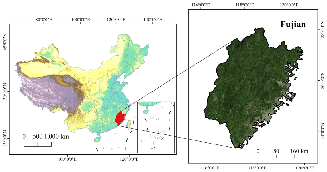
Figure 2.
Spatial distribution of mining patches and dataset samples in Fujian Province. (a) Spatial distribution of mining patches; (b) spatial distribution of training, validation, and test samples.
Figure 2.
Spatial distribution of mining patches and dataset samples in Fujian Province. (a) Spatial distribution of mining patches; (b) spatial distribution of training, validation, and test samples.
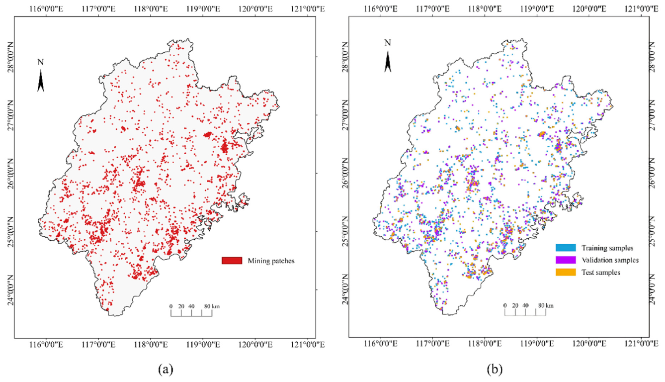
Figure 3.
Sample examples of different mines in the CUG-FJMine dataset.
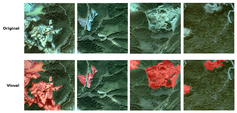
Figure 4.
Statistics of mining-area proportions in the samples.
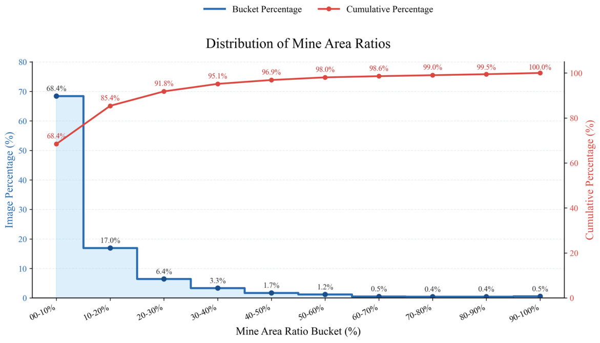
Figure 5.
Overall network structure of SWDF-Net.
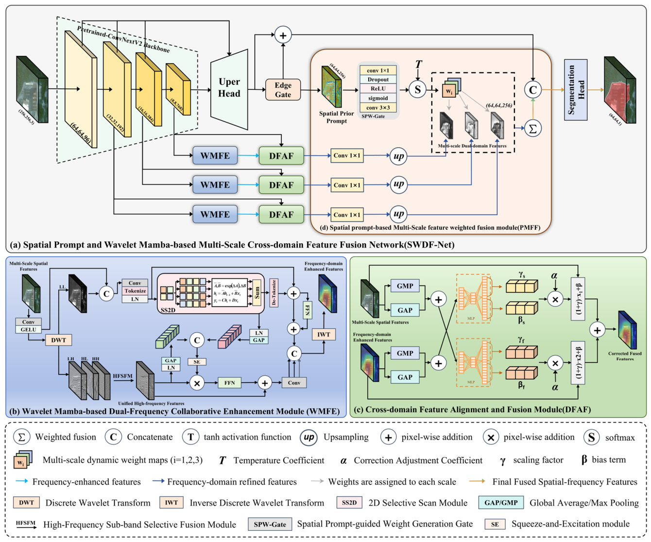
Figure 6.
Architecture diagram of the wavelet Mamba-based dual-frequency collaborative enhancement module.
Figure 6.
Architecture diagram of the wavelet Mamba-based dual-frequency collaborative enhancement module.
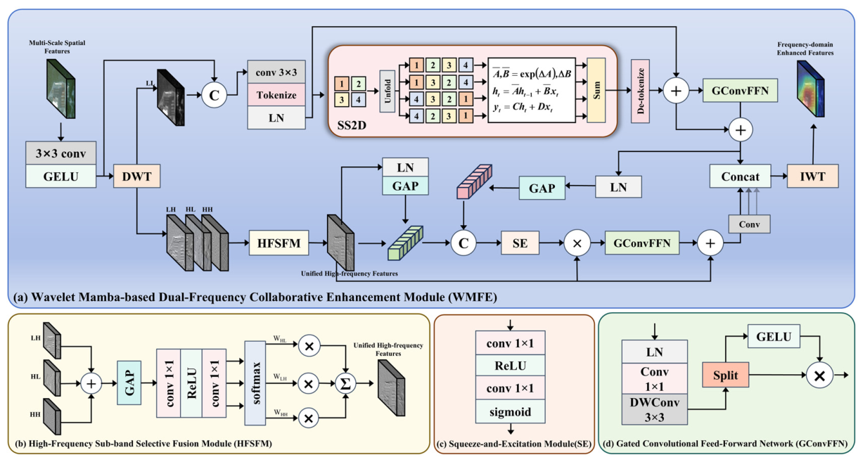
Figure 7.
Visualization of the experimental results of different methods on the CUG-FJMine dataset. The yellow boxes highlight regions where SWDF-Net achieves the most notable improvements.
Figure 7.
Visualization of the experimental results of different methods on the CUG-FJMine dataset. The yellow boxes highlight regions where SWDF-Net achieves the most notable improvements.
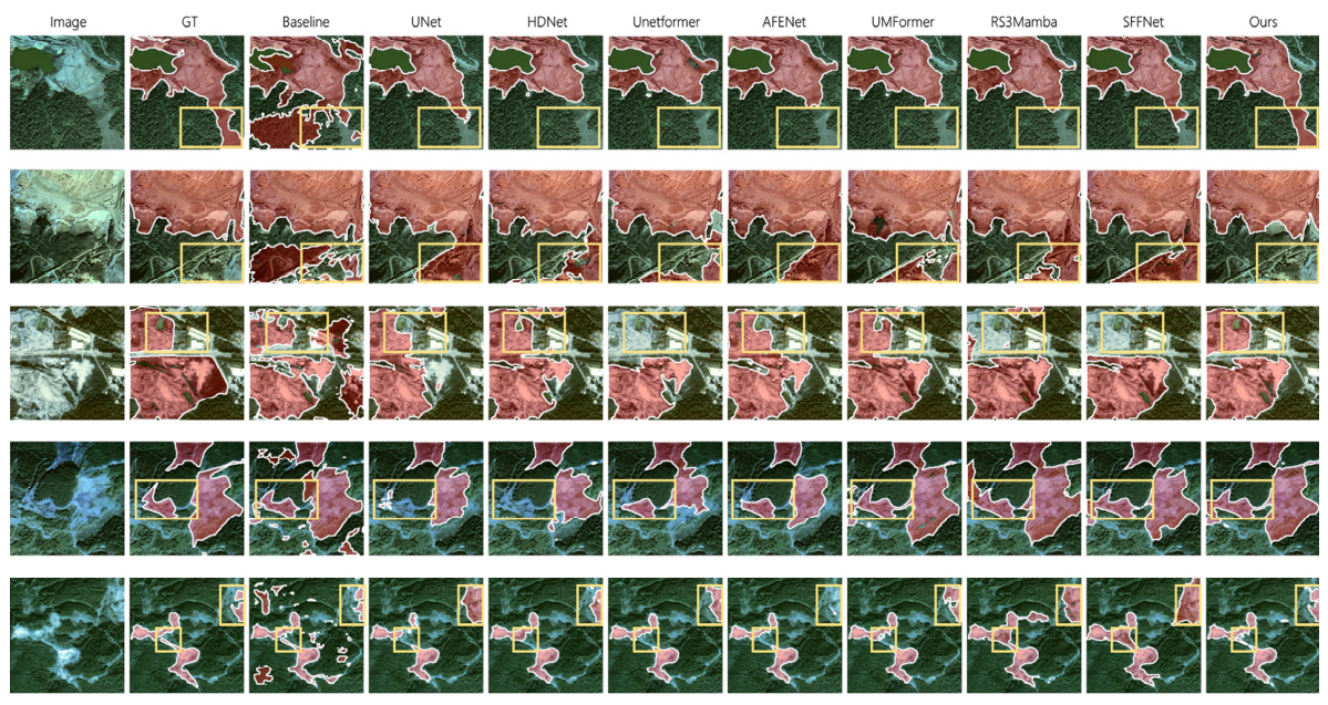
Figure 8.
Visualization of experimental results of different methods on the ISPRS Vaihingen Dataset. The purple boxes highlight key regions, including building clusters, small objects, and low vegetation, where edge details are complex.
Figure 8.
Visualization of experimental results of different methods on the ISPRS Vaihingen Dataset. The purple boxes highlight key regions, including building clusters, small objects, and low vegetation, where edge details are complex.
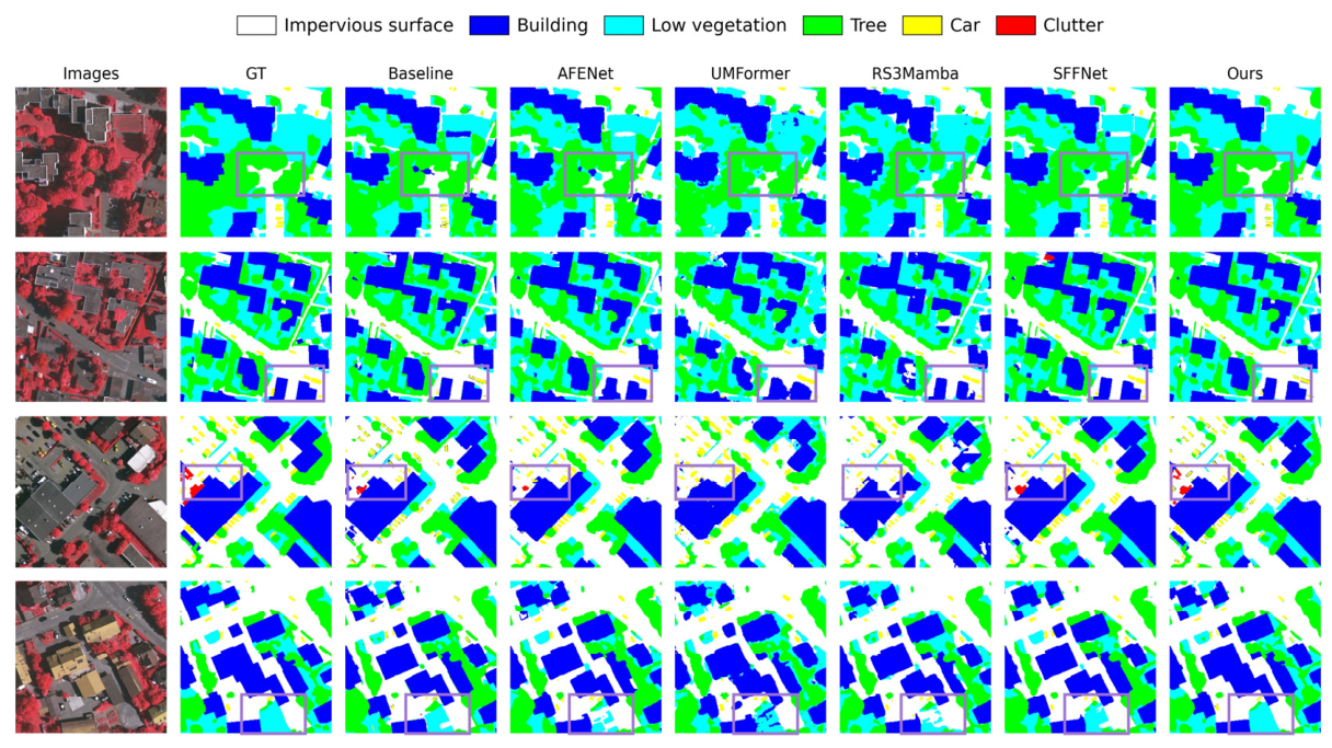
Figure 9.
Visualization of the ablation results of WMFE, DFAF, and PMFF in SWDF-Net, where (a)–(g) correspond to Models 2–7, respectively. Baseline denotes Model 1, and Ours denotes Model 8. The regions highlighted by yellow boxes indicate the areas with the most significant performance improvements, where SWDF-Net exhibits superior segmentation performance.
Figure 9.
Visualization of the ablation results of WMFE, DFAF, and PMFF in SWDF-Net, where (a)–(g) correspond to Models 2–7, respectively. Baseline denotes Model 1, and Ours denotes Model 8. The regions highlighted by yellow boxes indicate the areas with the most significant performance improvements, where SWDF-Net exhibits superior segmentation performance.
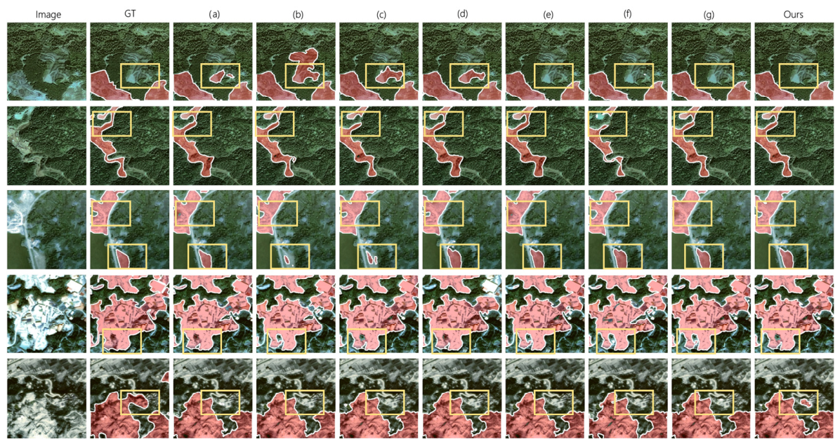
Figure 10.
Visualization of the experimental results of different methods on the CUG-FJMine dataset.
Figure 10.
Visualization of the experimental results of different methods on the CUG-FJMine dataset.
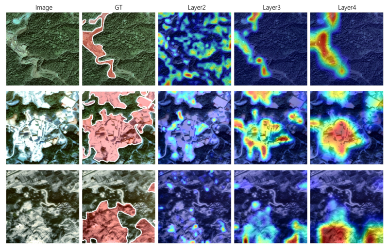
Figure 11.
Visualization of segmentation results in a complex mining scene. The red regions indicate mining areas, where GT denotes the manual annotation and Prediction denotes the model prediction.
Figure 11.
Visualization of segmentation results in a complex mining scene. The red regions indicate mining areas, where GT denotes the manual annotation and Prediction denotes the model prediction.
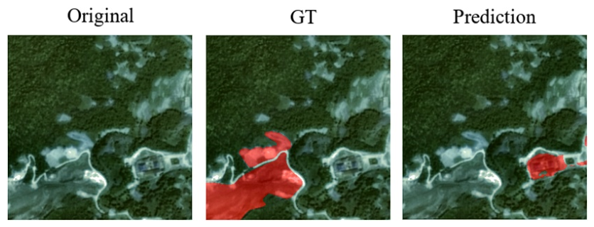

Table 1.
Experimental results of different methods on the CUG-FJMine dataset.
| Methods | Year | IoU(%) | F1-score(%) | Recall(%) | Precision(%) |
|---|---|---|---|---|---|
| Unet [48] | 2015 | 57.88 | 73.32 | 71.23 | 75.54 |
| Unetformer [49] | 2022 | 66.78 | 80.08 | 78.97 | 81.23 |
| ConvNeXtV2 [45] | 2023 | 69.27 | 81.84 | 80.50 | 83.23 |
| HD-Net [50] | 2024 | 60.77 | 75.60 | 79.10 | 72.39 |
| RS3Mamba [51] | 2024 | 62.92 | 77.24 | 83.63 | 71.76 |
| SFFNet [22] | 2024 | 67.58 | 80.66 | 75.48 | 86.59 |
| UMFormer [52] | 2025 | 65.95 | 79.48 | 78.91 | 80.07 |
| AFENet [53] | 2025 | 63.86 | 77.94 | 76.62 | 79.31 |
| Ours | — | 72.22 | 83.87 | 83.35 | 84.39 |
Table 2.
Experimental results of different methods on the ISPRS Vaihingen dataset.
| Methods | lmp.surf. | Building | Lowve. | Tree | Car | mF1 | OA | mIOU |
|---|---|---|---|---|---|---|---|---|
| U-Net [46] | 84.33 | 86.48 | 73.13 | 83.89 | 40.82 | 73.73 | 82.02 | 60.92 |
| SegViT [54] | 91.97 | 95.26 | 82.24 | 90.84 | 80.68 | 88.20 | 90.50 | 79.35 |
| Unetformer [47] | 92.70 | 95.30 | 84.90 | 90.60 | 88.50 | 90.40 | 91.00 | 82.70 |
| CMTFNet [55] | 90.61 | 94.21 | 81.93 | 87.56 | 82.77 | 87.42 | 88.71 | 77.95 |
| ConvNeXtV2[43] | 93.16 | 95.36 | 83.56 | 89.57 | 84.45 | 89.22 | 88.49 | 80.86 |
| RS3Mamba [49] | 92.83 | 96.82 | 80.84 | 91.10 | 90.09 | 90.34 | 87.87 | 82.78 |
| SFFNet [27] | 93.51 | 96.25 | 85.94 | 91.43 | 91.24 | 91.67 | 91.91 | 84.80 |
| AFENet [51] | 96.90 | 95.72 | 85.07 | 90.64 | 89.37 | 91.54 | 91.67 | 84.55 |
| UMFormer [50] | 96.70 | 95.20 | 83.80 | 89.50 | 88.10 | 90.70 | 93.00 | 83.30 |
| Ours | 94.43 | 96.80 | 86.28 | 92.13 | 90.82 | 92.09 | 91.96 | 85.54 |
Table 3.
Ablation results of WMFE, DFAF, and PMFF in SWDF-Net.
| Model | WMFE | DFAF | PMFF | IoU(%) | F1-score(%) | Recall(%) | Precision(%) |
|---|---|---|---|---|---|---|---|
| 1 | 69.27 | 81.84 | 80.5 | 83.23 | |||
| 2 | ✓ | 71.37 | 83.29 | 84.01 | 82.59 | ||
| 3 | ✓ | 71.01 | 83.05 | 82.52 | 83.59 | ||
| 4 | ✓ | 70.27 | 82.54 | 81.26 | 83.86 | ||
| 5 | ✓ | ✓ | 71.31 | 83.25 | 82.94 | 83.56 | |
| 6 | ✓ | ✓ | 71.52 | 83.39 | 83.91 | 82.88 | |
| 7 | ✓ | ✓ | 71.86 | 83.63 | 82.82 | 84.44 | |
| 8 | ✓ | ✓ | ✓ | 72.22 | 83.87 | 83.35 | 84.39 |
Disclaimer/Publisher’s Note: The statements, opinions and data contained in all publications are solely those of the individual author(s) and contributor(s) and not of MDPI and/or the editor(s). MDPI and/or the editor(s) disclaim responsibility for any injury to people or property resulting from any ideas, methods, instructions or products referred to in the content. |
© 2026 by the authors. Licensee MDPI, Basel, Switzerland. This article is an open access article distributed under the terms and conditions of the Creative Commons Attribution (CC BY) license (http://creativecommons.org/licenses/by/4.0/).
Copyright: This open access article is published under a Creative Commons CC BY 4.0 license, which permit the free download, distribution, and reuse, provided that the author and preprint are cited in any reuse.


