

Submitted:
01 July 2026
Posted:
02 July 2026
You are already at the latest version
Abstract
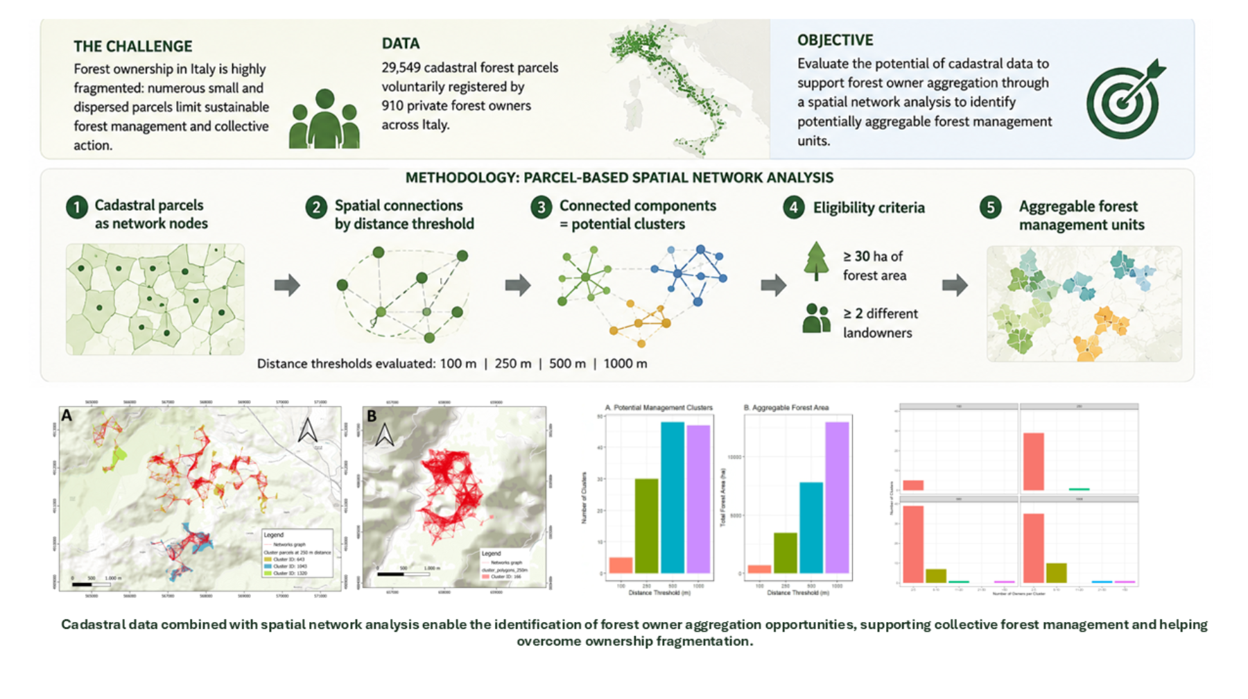
Forest ownership fragmentation represents a major constraint to sustainable forest management in many European countries, particularly in Italy, where private forests are often divided into small and spatially dispersed holdings. This study evaluates the potential of cadastral data to support forest owner aggregation through a graph-based spatial network analysis implemented within the Forest Sharing® platform. The analysis was conducted on 29,549 cadastral forest parcels voluntarily registered by 910 private forest owners across Italy. Parcels were represented as nodes in a spatial network and connected using four aggregation-distance thresholds (100, 250, 500, and 1000 m). Connected components were interpreted as potential forest management clusters. Only clusters including at least 30 ha of forest area and a minimum of two owners were retained. The proposed methodology successfully identified aggregable forest management units under all scenarios. Increasing aggregation distances substantially increased both the number of eligible clusters and the total forest area available for collective management. The number of clusters increased from 5 at the 100 m threshold to 48 at 500 m, while the aggregable forest area increased from approximately 700 ha to more than 12,000 ha at the 1000 m threshold. Most clusters involve two and five owners, indicating that substantial aggregation opportunities can be achieved without excessive ownership complexity. The study highlights the potential of cadastral information and spatial network analysis to support forest owner associations, collective management initiatives, and forest policy measures aimed at overcoming ownership fragmentation.
Keywords:
forest ownership fragmentation
; forest owner aggregation
; forest owner associations
; land information systems
; collective forest management
; spatial network analysis
1. Introduction
Sustainable forest management increasingly relies on the availability of accurate and up-to-date spatial information [1,2,3,4], among which cadastral data play a fundamental role [5,6,7] as for all the territorial management strategies [8]. In Europe approximately 60% of the forest area, representing nearly one billion hectares of forest land, is privately owned [9]. In many European countries, forest ownership is characterized by a high degree of fragmentation, with numerous small and dispersed forest owners [10,11,12,13,14]. In fact, according to Schmithüsen and Hirsch (2010) [15], 61% of all private forest holdings are smaller than 1 hectare, while only 1% exceed 50 hectares. Large private forest estates are relatively uncommon in Europe, with notable exceptions in countries such as countries such as Sweden and Finland [16]. This challenge is even more pronounced in Southern Europe in country such as Italy and Spain [17,18].
At Italian national level, forest ownership is characterized by a highly fragmented structure. Giannetti et al. (2023) [10]reported an average forest holding of only 8.2 ha per owner, considerably smaller than the European average of 12.7 ha [19,20]. Fragmentation is even more pronounced in the north-eastern Italian Alps [5], where Alberti et al. (2016) [21] found that 95% of cadastral forest parcels cover less than 1 ha.
Forest fragmentation, resulting from inheritance practices, land subdivision, and demographic changes, has created ownership structures characterized by numerous small and dispersed parcels [10,18,22,23,24,25,26]. This ownership structure is increasingly recognized as a major constraint for timber mobilization, coordinated forest management, and the provision of forest ecosystem services [16,27]. Indeed, fragmented ownership patterns often hinder cooperation among forest owners, resulting in higher operational costs, reduced management efficiency, limited participation in certification schemes, and difficulties in ensuring robust timber traceability and transparency along forest-based value chains [16,28,29]. One of the most relevant barriers identified by Põllumäe et al. (2016) [30] remains particularly relevant in the context of fragmented forest ownerships: the small size of individual holdings. Many owners perceive their forest properties as too limited to justify active management or participation in cooperative initiatives. This creates a paradox whereby the owners who could potentially benefit the most from aggregation are often those least inclined to engage in collective arrangements.
To address these challenges, policies across Europe increasingly promote the aggregation of forest owners through cooperatives, forest owner associations, producer organizations, and landscape-scale management initiatives [30]. Italy represents a notable example, since recent forest policy reforms, including the “Testo unico in materia forestale” (Legislative Decree No. 34/2018) and the National Forest Strategy [31], explicitly encourage forms of forest owner aggregation and coordinated management as key mechanisms to improve sustainable forest management, enhance wood mobilization, carbon stock, and strengthen the competitiveness of the forest sector.
In this context, cadastral information provides an essential basis for identifying defining property boundaries and supporting forest aggregation initiatives [32].
Among European Cadaster and land register many differences exist between countries that can be summarized as reported in Table 1.
Central European and Nordic systems are characterized by stronger legal integration between cadastral information and property registration, facilitating land governance, ownership verification, forest aggregation initiatives, and supply-chain traceability processes. On the contrary, Latin cadastral systems generally do not constitute legal proof of ownership, and property rights are established through land registry records and registered legal deeds.
Although the Italian cadastral system provides a comprehensive spatial framework for identifying land parcels and registered holders, cadastral records generally do not constitute legal proof of ownership. Property rights are legally established through land registry records and registered deeds. So, it could be possible that correspondence between cadastral records and actual ownership status may progressively weaken over time [33]. This issue is particularly relevant in jurisdictions, as the Italian one, where cadastral systems do not have legal probative value and where ownership rights are established through separate land registry systems, legal deeds, or inheritance procedures. This causes ownership information to become outdated due to unregistered inheritances, informal transfers, incomplete administrative updates, demographic changes, and long-term land abandonment [26]. Under such circumstances, identifying the current rights holder may require the reconstruction of ownership histories through multiple documentary sources, including historical cadastral records, land registry archives, notarial deeds, and succession documents. The complexity of this process increases with the number of ownership transfers and generations involved, often resulting in considerable uncertainty regarding the effective ownership of individual parcels. In the case of forest land, this situation may lead to two major issues: the presence of parcels with unknown ownership [34] and, even where ownership records have been correctly maintained, the progressive fragmentation of forest properties [5,10]. Such fragmentation can significantly hinder the implementation of efficient and sustainable forest management practices.
An important exception among all the Regions in Italy is represented by the Autonomous Provinces of Trento and Bolzano, where the Austro-Hungarian land registration system (Libro Fondiario/Grundbuch) is still in force and provides legal certainty regarding property rights through the registration of real estate interests.
The different institutional framework governing property rights in these provinces may have implications for forest governance and management planning. According to the data of the National Forest Information System (SINFor - https://sinfor.sian.it/ ) and the two indicators B.5 Forest Management Plans, and B.6 Equivalent Planning Instruments, the Autonomous Province of Bolzano records the highest proportion of forest area covered by management plans in Italy (87.3%), followed by the Autonomous Province of Trento (approximately 68%), while the national average is only 18.4%. Secure and clearly identifiable ownership rights may facilitate the identification of landholders, reduce transaction costs associated with planning processes, and support long-term management decisions. Such institutional conditions are particularly relevant in forestry, where management interventions typically require long planning horizons and coordination among multiple stakeholders. However, the exceptional planning coverage observed in Trentino and in South Tyrol is likely the result of a combination of factors, including a long-established tradition of forest management, strong local forestry institutions, and the economic relevance of forest resources. Nevertheless, the contrast with the national average suggests that the legal and administrative framework regulating property rights may represent an important enabling factor for the adoption of forest management plans and, more broadly, for the effectiveness of forest governance systems. At the same time, irrespective of the legal framework governing property rights, cadastral databases remain the primary operational source of spatial information for evaluating opportunities for forest parcel aggregation. By enabling the identification of spatially contiguous or functionally connected forest properties, including those belonging to different owners, cadastral data support the development of cooperative management arrangements, owner associations, forest management planning, land consolidation initiatives, and timber traceability systems throughout Italy.
Within the framework of the Italian Forest Strategy, initiatives aimed at restoring the active and coordinated management of forest lands owned by small-scale private proprietors require renewed efforts to identify and reconnect with forest owners, many of whom may live far from their properties [10] and may no longer be aware of their exact location or ownership status. This process requires the collection and updating of ownership information through dedicated communication and outreach activities. In this context, Forest Sharing® represents a practical example of a digital platform designed to facilitate the identification and engagement of forest owners. The platform provides a user-friendly interface through which landowners can register their forest properties by entering basic cadastral identifiers. These data are then used to retrieve the corresponding cadastral geometries, enabling the system to perform a range of spatial and management-related analyses. Several of these analytical functionalities have been described in detail by Giannetti et al. (2023) [10].
Beyond the extraction of forest inventory and environmental information [5,35,36], cadastral geometries also provide spatial basis for evaluating potential cooperation among neighbouring forest owners. In highly fragmented ownership contexts, coordinated management among adjacent or nearby properties may represent an effective strategy to reduce operational costs, increase management efficiency, and facilitate the implementation of shared silvicultural practices. By exploiting the geographic information embedded in cadastral data, it is therefore possible to identify and analyse potential ownership aggregation groups, providing a preliminary framework for the development of participatory and collaborative forest management processes and for the creation of forest owner associations aimed at overcoming ownership fragmentation.
The objective of this study is to assess the potential of cadastral information to support the aggregation of small forest owners and promote sustainable forest management in fragmented forest ownership scenarios. The analysis is based on a spatial network model developed from forest parcels voluntarily uploaded by private forest owners to the Forest Sharing® platform. Through the identification of spatially connected ownership units and potential management clusters, the study evaluates how cadastral data can facilitate collective forest management strategies.
2. Materials and Methods
2.1. Study Area and Dataset
The analysis was conducted using a total of 29,549 cadastral parcel representing 25,917 ha of forest subscribed by 910 owners in Forest Sharing® platform [10], which gathers information on private forest ownerships distributed across Italy (Figure 1). Forest ownership was highly fragmented and dominated by small holdings. Approximately 67% of owners possessed less than 5 ha of forest land, while about 11% owned between 5 and 10 ha and 6.5% between 10 and 20 ha. The proportion of owners declined steadily with increasing ownership size, with only about 4% owning 20–40 ha and less than 3% owning 40–60 ha. Ownerships larger than 100 ha represented approximately 6% of all owners, indicating a strongly skewed ownership structure characterized by a predominance of small forest properties and a relatively limited share of large holdings (Figure 2).
The cadaster parcel dataset consists of georeferenced cadastral parcels associated with individual forest owners through a unique identifier. Each cadastral parcel was represented as a polygon feature and constituted the basic spatial unit of analysis.
All spatial data were projected in the WGS84/UTM Zone 32N coordinate reference system (EPSG: 32632) to ensure metric consistency in distance and area calculations.
For each parcel, the following attributes were derived:
- unique parcel identifier;
- owner identifier;
- parcel area (ha);
- geographic coordinates of an internal representative point.
Parcel area was calculated directly from cadastral geometries and expressed in hectares.
2.2. Parcel-Based Spatial Network Construction to identify Potentially Aggregable Forest Management Units
A network-based approach was adopted to identify potential management aggregations among fragmented forest parcels. Each cadastral parcel was represented as a node in a spatial graph. To reduce computational complexity while preserving spatial relationships, a representative point was generated within each parcel polygon using the point-on-surface method.
Spatial connections between parcels were established according to predefined Euclidean distance thresholds. Two parcels were considered connected when the Euclidean distance between their representative points was lower than a specified threshold.
Four alternative aggregation scenarios were evaluated: (i) 100 m; (ii) 250 m; (iii) 500 m; (iv) 1000 m.
These thresholds were selected to represent increasing levels of spatial aggregation that could potentially be achieved through collaborative forest management initiatives.
For each distance threshold, an undirected graph was constructed in which:
- nodes represented cadastral parcels;
- edges represented spatial proximity relationships between parcels.
Spatial analyses and graph-based clustering procedures were performed using the R statistical environment (R Core Team, Vienna, Austria), employing the sf package for spatial data processing and the igraph package for network analysis.
Connected components were identified using graph-theoretical methods. Each connected component was interpreted as a potential forest management cluster, defined as a group of forest parcels that could potentially be managed through coordinated planning and operational activities.
Not all connected components were considered operationally relevant. Therefore, a minimum aggregation threshold was introduced. A cluster was classified as aggregable when the total forest area contained within the cluster was equal to or greater than 30 ha.
In addition, clusters involving only a single owner were excluded from subsequent analyses, as they do not represent a collaborative aggregation process.
Consequently, only clusters satisfying both of the following criteria were retained:
- total forest area within the cluster ≥ 30 ha;
- at least two distinct owners.
These criteria were adopted to identify clusters that combine a minimum operational scale with the presence of multiple landowners, thereby representing suitable candidates for collaborative forest management and ownership aggregation initiatives.
2.3. Cluster Characterisation
For each aggregation scenario (100, 250, 500, and 1000 m), a set of cluster-level indicators was calculated to evaluate the effects of increasing spatial aggregation distances on forest resource availability and ownership structure. The indicators were grouped into three categories, as reported in Table 2.
These indicators were subsequently used to assess how different aggregation thresholds influence both the amount of forest resources that could potentially be managed collectively and the complexity of the associated governance arrangements.
3. Results
The cluster-based analysis successfully identified aggregable forest management units under all four aggregation-distance scenarios (100, 250, 500, and 1000 m). In each case, clusters meeting the predefined eligibility criteria—namely a minimum forest area of 30 ha and the presence of at least two distinct landowners—were detected. The number, size, and ownership composition of these clusters varied according to the aggregation threshold, reflecting the influence of spatial proximity on the formation of potential collaborative management units.
Figure 3 provides an illustrative example of three forest management clusters identified using a maximum aggregation distance threshold of 250 m. The clusters were generated through a network-based approach in which cadastral parcels are connected according to their spatial proximity. In Figure 3, the red lines represent the network connections among parcels, while the colored polygons identify the parcels belonging to each cluster.
In Figure 3 panel A, three different clusters are shown. The Cluster ID 643, displayed in dark yellow, comprises 276 cadastral parcels owned by three landowners and encompasses a total forest area of 54 ha. Cluster ID 1043 (blue) includes 86 cadastral parcels owned by four landowners with a total forest area of 42 ha, while Cluster ID 1320 (green) consists of 47 cadastral parcels owned by three landowners and covers 40 ha of forest land.
Figure 3 Panel B shows the Cluster ID 166 characterized by the highest ownership complexity for the 250 m distance. This cluster involves 15 landowners and includes 248 cadastral parcels, covering a total forest area of 45 ha.
These examples illustrate how highly fragmented forest ownership can be consolidated into spatially coherent management units through the proposed clustering approach, thereby creating potential opportunities for collaborative forest management.
The distance threshold had a substantial effect on both the number of potential management clusters and the total forest area that could be aggregated (Figure 4). Increasing the threshold from 100 m to 250 m resulted in a marked increase in the number of eligible clusters, from 5 to 30. The number of clusters further increased to 48 at the 500 m threshold, indicating a significant improvement in the connectivity among fragmented forest parcels. However, at the 1000 m threshold, the number of clusters slightly decreased to 47. This reduction suggests that some clusters identified at 500 m became connected and merged into larger aggregations when a greater distance threshold was applied.
The total aggregable forest area showed a continuous increase with increasing distance thresholds. The area rose from approximately 700 ha at 100 m to about 3,400 ha at 250 m and nearly 8,000 ha at 500 m, reaching more than 12,000 ha at the 1000 m threshold.
The distribution of cluster sizes varies substantially across the tested distance thresholds (Figure 5). At the 100 m threshold, only a limited number of clusters satisfy the aggregation criteria, and these are distributed across a relatively wide range of area classes, indicating that opportunities for aggregation are scarce and spatially constrained.
Increasing the threshold to 250 m leads to a marked increase in the number of eligible clusters, particularly within the smaller area classes (40–80 ha). This suggests that moderate increases in the allowable distance between parcels substantially improve the connectivity of fragmented forest properties, enabling the formation of a greater number of management units.
The 500 m threshold produces the highest concentration of clusters in the smallest area classes, while simultaneously expanding the distribution toward larger cluster sizes. This indicates that many previously isolated parcels become integrated into coherent management units.
At the 1000 m threshold, the overall distribution remains similar to that observed at 500 m, although the frequency of medium- and large-sized clusters increases further. This pattern suggests that increasing the distance threshold beyond 500 m contributes primarily to the enlargement of existing clusters rather than to the creation of new ones.
Figure 6 illustrates the ownership composition of aggregable forest clusters under four aggregation-distance scenarios (100, 250, 500, and 1000 m). Across all scenarios, the majority of clusters are characterized by a relatively simple ownership structure, with most clusters falling within the 2–5 owners category. However, increasing the aggregation distance progressively increases both the number of aggregable clusters and their ownership complexity.
Under the 100 m scenario, only a limited number of clusters are identified, all of which are composed of 2–5 owners, indicating relatively straightforward ownership arrangements. When the aggregation threshold is increased to 250 m, the number of clusters rises substantially, while the predominance of the 2–5 owners category remains largely unchanged. At this threshold, the first cluster involving 11–20 owners appear.
The 500 m scenario further expands aggregation opportunities, resulting in a greater number of clusters and a broader distribution of ownership classes. Although clusters with 2–5 owners continue to dominate, clusters involving 6–10, 11–20, and more than 50 owners also emerge. A similar pattern is observed under the 1000 m scenario, where ownership complexity increases further, particularly through the growth of clusters containing 6–10 owners with a subsequent reduction in the category 2-5 owners.
4. Discussion
Graph-based methods are well established in both land administration and forest science, and it is useful to state at the outset what the present approach adds [37]. Clustering and graph-theoretic algorithms have been used to regroup fragmented holdings as a basis for land consolidation [37], while in landscape ecology, the representation of patches, linked by distance-based edges, as nodes (with connectivity assessed through connected components) has been considered as a standard since Urban and Keitt (2001) [38]. The analysis proposed adopts this same graph construction approach, redirecting its specific objective: rather than physically reorganising property or modelling ecological connectivity, it treats existing cadastral parcels as fixed nodes and identifies where coordinated management among different owners is spatially plausible, without altering ownership boundaries. In this particular instance, the innovative aspect of the specific graph-based approach lies less in the algorithm itself, and more in the application performed here. Specifically, cadastral parcels have been used as the unit of owner aggregation, which has been embedded within an operational digital platform (Forest Sharing®) that can turn the resulting clusters into a strong starting point for connecting owners and promoting association processes.
On these bases, the results demonstrate that the network-based approach can identify aggregation opportunities even in contexts characterised by highly fragmented ownership structures and numerous small, spatially dispersed cadastral parcels, thereby representing a first step towards coordinated forest management. In fact, cadastral information can be effectively used to identify potential forest management clusters and quantify aggregation opportunities within small-scale and fragmented forest ownerships. Through spatial network analysis, disconnected cadastral parcels can be grouped into operationally meaningful management units, overcoming one of the main structural constraints affecting private forestry in Europe: the small size and fragmentation of forest land. In fact, while cadastral systems traditionally support ownership registration and land administration [37], the results demonstrate their potential as a decision-support tool for identifying cooperative forest management opportunities [8].
However, the identification of spatially aggregable clusters should be regarded only as the first step in the aggregation process [17]. While geographic proximity and spatial coherence are fundamental prerequisites for joint forest management, the existence of spatially connected parcels in clusters does not automatically translate into effective cooperation among forest owners [24,34]. As highlighted by Põllumäe et al. (2016) [30], forest owner cooperation is influenced by a broad set of formal and informal barriers that extended beyond the physical characteristics of forest properties. These include general disinterest in participation in forest owner organizations, lack of information, time constraints, individualistic management attitudes, low trust in collective initiatives, and the perception that forest holdings are too small or economically unattractive to justify cooperation [12,24,35]. In this context, the Forest Sharing® platform represents a potentially important mechanism for reducing some of these barriers. Unlike the general population of forest owners analysed by Põllumäe et al. (2016) [30], the owners included in Forest Sharing® voluntarily joined the platform and agreed to share information regarding their forest properties. This self-selection process may already reduce some of the informational, motivational and organisational barriers typically associated with cooperation, as participants have expressed at least an initial interest in exploring collective management opportunities. Furthermore, the network-analysis facilitates the identification of neighboring owners, increases transparency regarding property distribution, and creates opportunities for communication among landowners who would otherwise remain disconnected.
The practical relevance of the proposed methodology is demonstrated by its direct applicability to public policies aimed at promoting forest owner aggregation and collective forest management [31].
A notable example is the 2024 Tuscany Regional Forest Fund financed by the National Forest Strategy [31], which allocated in 2025 € 515,518 to support the establishment of new forest associations and the strengthening of existing associative forms with the objective of counteracting ownership fragmentation, increasing forest planning, enhancing local environmental and productive values, and promoting sustainable forest management. Within this framework, eligible projects were required to involve a minimum aggregated forest area of 100 ha and include at least one continuous forest block larger than 20 ha. In addition, funded activities included cadastral investigations, territorial surveys, thematic cartography, forest resource inventories, stakeholder coordination, awareness-raising activities, the preparation of multiannual forest management plans, and the development of organisational structures for collective forest governance. In this regard, the methodology proposed in this study directly supports many of these preliminary requirements. By integrating cadastral information with spatial network analysis, it enables the identification of geographically coherent forest management clusters, the quantification of aggregated forest area, the assessment of ownership composition, and the delineation of potential management units suitable for collective planning. Furthermore, the resulting spatial datasets can support cadastral investigations, thematic mapping activities, territorial analyses, and the preliminary design of forest owner associations. Moreover, beyond the identification of candidate aggregation areas, the approach provides objective indicators that can be used to assess the territorial consistency and operational feasibility of potential associations, including the number of participating owners, the degree of ownership fragmentation, and the total forest area available for joint management.
The different distance thresholds tested in this study produced substantially different aggregation patterns, highlighting the importance of selecting an appropriate spatial criterion when identifying potential forest management clusters.
The 100 m threshold proved to be highly restrictive, identifying only a limited number of multi-owner clusters. While this distance ensures a high degree of spatial proximity among parcels, it may underestimate aggregation opportunities in highly fragmented ownership contexts, where neighbouring forest properties are often separated by small infrastructure elements, agricultural land, or other landscape features.
The 250 m threshold appears to represent the most balanced and operationally meaningful aggregation criterion among those tested. From a forest management perspective, the contiguity of management units is a key factor influencing operational efficiency and harvesting costs. Spatially compact clusters facilitate the coordination of silvicultural interventions, reduce travelling distances between stands, and improve the overall efficiency of forest operations.
In particular, the 250 m threshold allows the aggregation of parcels that are functionally connected while maintaining a relatively high degree of spatial cohesion. Such a distance can accommodate the presence of local roads, forest trails, agricultural clearings, or minor landscape discontinuities without compromising the operational integrity of the management unit. At the same time, it avoids the excessive spatial dispersion that may emerge when larger thresholds are applied. The identification of compact clusters at 250 m distance is also relevant for the joint planning of forest infrastructures. Forest roads, skid trails, extraction routes, and landing areas are among the most expensive components of forest management in fragmented ownership contexts. The possibility of planning and sharing these infrastructures across multiple neighbouring properties may substantially reduce investment and operational costs while increasing accessibility to forest resources. Therefore, the 250 m threshold appears particularly suitable for supporting both coordinated forest operations and the collective planning of forest infrastructure networks.
The economic rationale for forest owner aggregation is not only related to direct production costs but, to a larger extent, to transaction costs. As Zhang (2001) [41] argued, mainstream forest economics tends to overlook the costs of coordinating, contracting, and monitoring management arrangements, which transaction-cost economics places at the center of the analysis. In fragmented ownership contexts, these costs are disproportionately high: individual holdings are too small to absorb the fixed costs of planning, access, and supervision, and the effort required to identify and reach agreement with neighboring owners can be considerable. Coordinating owners for joint management has been shown to lower these transaction costs while improving the coherence of silvicultural actions at the landscape scale [28]. The spatial clusters identified in this study address exactly the first of these costs by making the distribution of neighboring properties explicit. The remaining gains, however, depend on the operational structure of the resulting management units. Forest operations usually account for a large share (in the order of 40 to 60% in forest enterprises [42]) of total management costs. Within these, timber harvesting is the single most expensive phase. Because extraction productivity declines sharply with increasing extraction distance (falling by a factor of two when ground-skidding distance increases from about 200 to 800 m [43]) the design and organisation of the forest road and trail network is a key factor in maintaining competitive harvesting costs. Although the 250 m clustering threshold does not directly determine extraction distances, it creates larger and more contiguous management units that make coordinated planning of silvicultural operations, harvesting activities, and forest infrastructure feasible. The 250 m threshold allows forest roads, skid trails, and landings (whose optimal density is itself determined by the trade-off between construction and extraction costs [44]) to be planned and shared across several owners. Since the planning of such infrastructure represents only a small fraction of harvesting expenditure (on the order of 1% of the cost per cubic meter) [45] but is rarely viable at the level of a single small holding, its coordination across a cluster is one of the clearest economic benefits that aggregation can deliver [46]. Furthermore, the risk of building useless or redundant infrastructure is significantly reduced approaching forest road network planning in a cluster; this also leads to a reduction in the direct and indirect environmental risks and impacts associated with the construction and maintenance of forest roads and trails (e.g., landslide and erosion risks, sediment pollution, and anthropogenic disturbance to sensitive species).
The larger thresholds of 500 m and 1000 m further increase the connectivity of the network by linking neighbouring clusters and incorporating a greater number of forest owners and parcels into the same management unit (Figure 2). Although these distances may reduce the spatial compactness of individual clusters, they can enhance the efficiency of associative forest management by increasing the territorial scale of the organisation. Larger management units may facilitate the sharing of administrative and technical costs, improve the economic viability of collective initiatives, and strengthen the capacity of forest owner associations to implement common management strategies.
Furthermore, larger aggregation thresholds may provide additional benefits in the context of forest certification schemes such as PEFC and FSC®. Group certification systems are specifically designed to reduce certification costs through the aggregation of multiple forest owners under a common organisational framework. Consequently, larger and more connected clusters may increase the feasibility of certification processes by distributing auditing, administrative, and management costs across a wider forest area and a larger number of participants.
However, the results also highlight an important governance issue. Some of the identified clusters extend across regional administrative boundaries. Although Italy has a national legislative framework through the Consolidated Forest Law (D.Lgs. 34/2018), forest planning and management regulations are implemented at the regional level. As a consequence, forest management units located across regional borders may be subject to different planning procedures, technical requirements, and administrative approval processes. In practical terms, this means that a single associative forest management initiative could require the preparation and approval of management plans under two different regional regulatory systems. Such situations may increase transaction costs, administrative complexity, and implementation time, potentially reducing some of the efficiency gains generated by spatial aggregation.
Therefore, while larger distance thresholds may maximise aggregation opportunities and improve the economic viability of collective management arrangements, their practical implementation should also consider administrative boundaries and regulatory heterogeneity.
Moreover, methodological limitation concerns the representation of parcels as point-on-surface centroids: edges therefore encode the Euclidean distance between representative points rather than shared boundaries, so the network captures spatial proximity but not true adjacency or operational accessibility. This simplification was adopted to ensure computational scalability across such large number of parcels and to consider a threshold of tolerance for minor landscape discontinuities, but it may connect parcels separated by physical barriers such as rivers, ridges, or minor roads and collapse the whole internal extent of large parcels to a single node. Contiguity-based graph constructions [37,47] offer a more accurate, if more demanding, alternative that future work could adopt.
While the results demonstrate that cadastral information is an effective tool for identifying potential forest aggregation opportunities, the transition from spatial aggregation to formal collective management arrangements requires the verification of actual ownership rights. In the current Forest Sharing® workflow, landowners are only required to provide cadastral identifiers, allowing the platform to retrieve parcel geometries and perform spatial analyses. However, the establishment of collective management agreements or forest owner associations would require additional documentary evidence, including notarial deeds, inheritance records, or other legal documents proving ownership.
In our experience, this requirement may represent a significant challenge for some forest owners. As ownership information becomes outdated due to unregistered inheritances, informal transfers, or incomplete administrative updates, the legal documentation required to demonstrate ownership may be difficult to retrieve or, in some cases, no longer available. Consequently, discrepancies between cadastral records and actual ownership status may emerge during the implementation of aggregation initiatives.
As highlighted by Ruggeri and Winkler (2020) [33], the traceability of property rights remains a critical issue in land information systems, particularly in countries such as Italy where cadastral records do not have legal probative value. Therefore, although cadastral data can effectively support the identification of potential aggregation opportunities, additional efforts aimed at verifying ownership rights and reconstructing ownership histories may be required before collaborative management schemes can be formally established. This process could potentially exclude a portion of forest owners from aggregation initiatives when ownership cannot be adequately demonstrated, thereby limiting the overall effectiveness of collective management strategies.
5. Conclusions
This study demonstrates that cadastral data and spatial network analysis can be effectively combined to identify potential forest owner aggregation opportunities in highly fragmented ownership contexts. The proposed approach provides a practical and replicable tool for supporting coordinated forest management and the development of collective management initiatives.
The main findings can be summarized as follows:
- Spatial network analysis successfully identified geographically coherent forest management clusters involving multiple owners.
- The methodology can directly support public policies and forest owner associations aimed at reducing ownership fragmentation and promoting collective forest management.
However, spatial proximity alone does not guarantee effective cooperation among forest owners. The successful implementation of aggregation initiatives also depends on legal, organisational, economic, and social factors that were beyond the scope of the present study. For this reason, future research should therefore:
- evaluate the economic viability of the identified clusters, including potential cost savings, economies of scale, and certification opportunities;
- investigate landowners’ willingness to cooperate, motivations, and perceived barriers to participation;
- integrate spatial, economic, and social dimensions to provide a more comprehensive assessment of the feasibility of collective forest management schemes.
Author Contributions
Conceptualization, Francesca Giannetti, Yamuna Giambastiani, Alessandro Errico; methodology, Francesca Giannetti, Yamuna Giamastiani, Alessandro Errico; software, Cristiano Guadagnino, Lorenzo Massai, Hervè Corti, Giacomo Pinzani, Reicht Prince Destine Batomene,; formal analysis, Francesca Giannetti, Giuliano Secchi; investigation, Francesca Giannetti, Giuliano Secchi, Jessica Scriva, Alessandro Errico, Yamuna Giambastiani; resources, Francesca Giannetti, Guido Milazzo, Yamuna Giambastiani, Willy Reggioni; data curation, Francesca Giannetti, Yamuna Giambastiani, Irene Fattoretto, Alessandro Errico, Jessica Scriva, Tommaso Tognetti; writing—original draft preparation, Giuliano Secchi, Francesca Giannetti.; writing—review and editing, Ilaria Zorzi, Alessandro Errico, Yamuna Giambastiani, Tommaso Tognetti, Jessica Scriva, Irene Fattoretto, Guido Milazzo, Cristiano Guadagnino, Niccolò Fani, Lorenzo Massai, Livia Passarino, Willy Reggioni, Ilaria Incollu, Bianca Rompato, Andrea Laschi, Cristiano Foderi; visualization, Francesca Giannetti; supervision, Francesca Giannetti; Project administration, Niccolò Fani, Guido Milazzo, Willy Reggioni; funding acquisition, Francesca Giannetti, Willy Reggioni, Guido Milazzo. All authors have read and agreed to the published version of the manuscript.” Please turn to the CRediT taxonomy for the term explanation. Authorship must be limited to those who have contributed substantially to the work reported.
Funding
This work was funded by the European Union’s Horizon Europe Research and Innovation Programme under: (i) the project “SMURF – Sustainable Management Models and Value Chains for Small Forests” (Grant Agreement No. 101135516), (ii) the project “SINTETIC – Single Item Identification for Forest Production, Protection and Management” (Grant Agreement No. 101082051), (iii) For.CO.2 - “Sviluppo di un sistema di supporto decisionale per migliorare l’assorbimento del carbonio nelle foreste della Riserva della Biosfera Appennino Tosco Emiliano” financed by Reg. UE 2021/2115, Art. 77 – CSR 2023/2027 della Regione Toscana – Approvazione del Bando attuativo dell’intervento SRG01 - Sostegno ai Gruppi Operativi del Partenariato Europeo per l’Innovazione in Agricoltura (PEI Agri) – Annualità 2024.
Data Availability Statement
The data presented in this study are not publicly available because they are proprietary and contain information subject to privacy and confidentiality constraints under the General Data Protection Regulation (GDPR, Regulation (EU) 2016/679). Therefore, raw data cannot be shared or distributed. However, the authors are willing to provide aggregated and processed data, upon reasonable request, for the purposes of future research and scientific collaboration, provided that such sharing complies with applicable legal and confidentiality obligations.
Acknowledgments
The authors would like to sincerely thank all forest owners participating in the Forest Sharing® platform. Their willingness to engage in innovative forms of collaboration and their commitment to exploring collective forest management solutions represent an important contribution towards addressing forest ownership fragmentation and fostering more sustainable forest management in Italy. The authors are also grateful for the patience, trust, and continued engagement of participating landowners throughout the aggregation process, which often requires considerable time, effort, and coordination before tangible results can be achieved. The authors further acknowledge the mayors, local administrators, and active stakeholders of the Garfagnana Green Community for their commitment to promoting sustainable rural and forest development. Their efforts to reverse long-term trends of land abandonment and forest fragmentation in one of Italy’s most heavily forested area provide an important foundation for the development of innovative and collaborative forest management approaches.
Conflicts of Interest
“The authors declare no conflicts of interest.”.
References
- D’amico, G.; Vangi, E.; Francini, S.; Giannetti, F.; Nicolaci, A.; Travaglini, D.; Massai, L.; Giambastiani, Y.; Terranova, C.; Chirici, G. Are We Ready for a National Forest Information System? State of the Art of Forest Maps and Airborne Laser Scanning Data Availability in Italy. IForest 2021, 14, 144–154. [Google Scholar] [CrossRef]
- Taylor, C.; Id, D.B.L. The Use of Spatial Data and Satellite Information in Legal Compliance and Planning in Forest Management; 2022; pp. 1–27. [Google Scholar] [CrossRef] [PubMed]
- Baskent, E.Z.; Guilherme, J.; Jan, B. An Updated Review of Spatial Forest Planning : Approaches, Techniques, Challenges, and Future Directions. Curr. For. Rep. 2024, 299–321. [Google Scholar] [CrossRef]
- Meddens, A.J.H.; Steen-adams, M.M.; Hudak, A.T.; Mauro, F.; Byassee, P.M. Specifying Geospatial Data Product Characteristics for Forest and Fuel Management Applications. Environ. Res. Lett. 2022, 17. [Google Scholar] [CrossRef]
- Cadez, L.; Giannetti, F.; de Luca, A.; Tomao, A.; Chirici, G.; Alberti, G. A WebGIS Tool to Support Forest Management at Regional and Local Scale. IForest 2023, 16, 361–367. [Google Scholar] [CrossRef]
- Iryna, K.; Ivan, S.; Arkadii, S.; Sisenis, L.; Luksa, J.; Sciences, L.; Jelgava, T. USE OF LAND MANAGEMENT AND CADASTRE DATA FOR; 2024; pp. 33–41. [Google Scholar]
- Kumar, K.E.M.; Singh, S.; Attri, P.; Kumar, R.; Kumar, A.; Hooda, R.S. GIS BASED CADASTRAL LEVEL FOREST INFORMATION SYSTEM USING WORLD VIEW-II DATA IN BIR HISAR ( HARYANA ). In Proceedings of the The International Archives of the Photogrammetry, Remote Sensing and Spatial Information Sciences, Volume XL-8, 2014 ISPRS Technical Commission VIII Symposium, Hyderabad, India, 09– 12 December 2014; 2014; Vol. XL, pp. 9–12. [Google Scholar]
- Cienciała, A.; Sobolewska-mikulska, K.; Sobura, S. Land Use Policy Credibility of the Cadastral Data on Land Use and the Methodology for Their Verification and Update. 2021, 102. [Google Scholar] [CrossRef]
- Živojinović, I.; Weiss, G.; Lidestav, G.; Feliciano, D.; Hujala, T.; Dobšinská, Z.; Lawrence, A.; Nybakk, E.; Quiroga, S.; Schraml, U. (Eds.) Forest Land Ownership Change in Europe: COST Action FP1201 FACESMAP Country Reports Joint Volume; European Forest Institute Central-East and South-East European Regional Office, 2015. [Google Scholar]
- Giannetti, F.; Laschi, A.; Zorzi, I.; Foderi, C.; Cenni, E.; Guadagnino, C.; Pinzani, G.; Ermini, F.; Bottalico, F.; Milazzo, G.; et al. Forest Sharing ® as an Innovative Facility for Sustainable Forest Management of Fragmented Forest Properties : First Results of Its Implementation. 2023. [Google Scholar] [PubMed]
- Kumer, P.; Slavic, I.P. Heterogeneous Small-Scale Forest Ownership: Complexity of Management and Conflicts of Interest. Belgeo 2016, 2016, 0–21. [Google Scholar] [CrossRef]
- Niroula, G.S.; Ã, G.B.T. Impacts and Causes of Land Fragmentation, and Lessons Learned from Land Consolidation in South Asia. 2005, 22, 358–372. [Google Scholar] [CrossRef]
- Weiss, G.; Gudurić, I.; Wolfslehner, B. Review of Forest Owner Organisations in Selected Eastern European Countries. In For. Policy Institutions Work. Pap. Nr. 30; FAO: Rome, 2012. [Google Scholar]
- Weiss, G.; Lawrence, A.; Hujala, T.; Lidestav, G.; Nichiforel, L.; Nybakk, E.; Quiroga, S.; Sarvašová, Z.; Suarez, C.; Živojinović, I. Forest Policy and Economics Forest Ownership Changes in Europe : State of Knowledge and Conceptual. For. Policy Econ. 2019, 99, 9–20. [Google Scholar] [CrossRef]
- Schmithüsen, F.; Hirsch, F. GENEVA TIMBER AND FOREST STUDY PAPER 26- PRIVATE FOREST OWNERSHIP IN EUROPE; Geneva, 2010. [Google Scholar]
- Weiss, G.; Lawrence, A.; Hujala, T.; Lidestav, G.; Nichiforel, L.; Nybakk, E.; Quiroga, S.; Sarvašová, Z.; Suarez, C.; Živojinović, I. Forest Ownership Changes in Europe: State of Knowledge and Conceptual Foundations. For. Policy Econ. 2019, 99, 9–20. [Google Scholar] [CrossRef]
- Loreggian, F.; Pettenella, D.; Secco, L.; Andrighetto, N.; Bottaros, G. ASSOCIATIVE ORGANISATIONAL MODELS IN ITALIAN FORESTS FOR ADDRESSING LAND ABANDONMENT ORGANIZACIJSKI MODELI POVEZOVANJA V ITALIJANSKIH GOZDOVIH ZA REŠEVANJE PROBLEMATIKE OPUŠČANJA ZEMLJIŠČ. Acta Silvae Ligni 2024, 134, 27–38. [Google Scholar] [CrossRef]
- Loreggian, F.; Andrighetto, N.; Masiero, M.; Storti, G. Analisi Dello Stato Dell’arte Dell’associazionismo Forestale in Italia; 2024. [Google Scholar]
- Ficko, A.; Lidestav, G.; Ní Dhubháin, Á.; Karppinen, H.; Zivojinovic, I.; Westin, K. European Private Forest Owner Typologies: A Review of Methods and Use. For. Policy Econ. 2019, 99, 21–31. [Google Scholar] [CrossRef]
- Mantero, G.; Morresi, D.; Marzano, R.; Motta, R.; Mladenoff, D.J.; Garbarino, M. The Influence of Land Abandonment on Forest Disturbance Regimes: A Global Review. Landsc. Ecol. 2020, 35, 2723–2744. [Google Scholar] [CrossRef]
- Alberti, G.; Danelon, M.; De Simon, G.; Florean, M.; Francescatto, N.; Muzzolini, V.; Pergher, G.; Piussi, P.; Sbrizzi, N.; Chiabà, D.; et al. Linee Guida per La Gestione Selvicolturale Di Boschi Misti Di Acero e Frassino Di Origine Secondaria: Aspetti Economici, Selvicolturali e Tecnologici; Regione Autonoma Friuli Venezia Giulia – Direzione centrale risorse agricole, forestali e ittiche – Area foreste e territorio - Servizio foreste e corpo forestale Centro servizi per le foreste e le attività della montagna Ente beneficiario: Dipartimento d, 2016. [Google Scholar]
- Cadez, L.; Tomao, A.; Giannetti, F.; Chirici, G.; Alberti, G. Mapping Forest Growing Stock and Its Current Annual Increment Using Random Forest and Remote Sensing Data in Northeast Italy. FORESTS 2024, 15. [Google Scholar] [CrossRef]
- Agnoletti, M.; Piras, F.; Venturi, M.; Santoro, A. Cultural Values and Forest Dynamics: The Italian Forests in the Last 150 Years. For. Ecol. Manag. 2022, 503, 119655. [Google Scholar] [CrossRef]
- Weiss, G.; Emery, M.; Miina, J.; Kurttila, M.; Corradini, G.; Huber, P.; Vacik, H. Value Creation and Innovation with Non-Wood Forest Products in a Family Forestry Context. In World For.; 2019. [Google Scholar] [CrossRef]
- Secco, L.; Paletto, A.; Romano, R.; Masiero, M.; Pettenella, D.; Carbone, F.; De Meo, I. Orchestrating Forest Policy in Italy : Mission Impossible ? Forests 2018, 9, 1–19. [Google Scholar] [CrossRef]
- Pawlewicz, A.; Pawlewicz, K. The Risk of Agricultural Land Abandonment as a Socioeconomic Challenge for the Development of Agriculture in the European Union; 2023. [Google Scholar]
- Stern, T.; Schwarzbauer, P.; Huber, W.; Weiss, G.; Aggestam, F.; Wippel, B.; Petereit, A.; Navarro, P.; Rodriguez, J.; Boström, C.; et al. Prospects for the Market Supply of Wood and Other Forest Products from Areas with Fragmented Forest-Ownership Structures. Final Study Rep. To Eur. Comm. (DG AGRI Tender No. AGRI-2008-EVAL-11) 2010. [Google Scholar]
- Górriz-mifsud, E.; Donazar, L.O.; Eseverri, E.M.; Marini, V.; Forest, E.; Pau, S.; Nouveau, A.; Pavilion, S.L.; Claret, S.A.M. Forest Policy and Economics The Challenges of Coordinating Forest Owners for Joint Management ☆. For. Policy Econ. 2019, 99, 100–109. [Google Scholar] [CrossRef]
- Ji, Y.; Wan, S. The Impact of the Governance Fragmentation of Forestry Communities on the Economic Performance of State-Owned Forest Enterprises in Northeast China : An Empirical Analysis Based on the Transaction Cost Perspective; 2024. [Google Scholar]
- Põllumäe, P.; Lilleleht, A.; Korjus, H. Forest Policy and Economics Institutional Barriers in Forest Owners ’ Cooperation : The Case of Estonia. For. Policy Econ. 2016, 65, 9–16. [Google Scholar] [CrossRef]
- Ministero delle politiche Agricole; Ministero della cultura; Ministero della transizione ecologica; Ministero dello Sviluppo Economico Strategia Forestale Nazionale. 2021; pp. 1–8.
- De Belém, M.; Freitas, C.; Teixeira, M.D.; Antunes, C.R.; Ribeiro, H.C.; Partidário, R. Beyond Cadaster : Landowners and Land Fragmentation — Insights from a Case Study 2026, 1–19. [CrossRef]
- Ruggeri, L.; Winkler, S. Family Property and Succession in EU Member States National Reports on the Collected Data; 2020; ISBN 9789538034251. [Google Scholar]
- Iovino, G. Recupero Dei Terreni Incolti e Il Ripopolamento Delle Aree Rurali; 2018; pp. 595–608. [Google Scholar]
- Marto, M.; Reynolds, K.M.; Borges, J.G.; Bushenkov, V.A.; Marques, S.; Marques, M.; Barreiro, S.; Botequim, B.; Tomé, M. Web-Based Forest Resources Management Decision Support System. Forests 2019, 10. [Google Scholar] [CrossRef]
- Sacchelli, S. A Decision Support System for Trade-off Analysis and Dynamic Evaluation of Forest Ecosystem Services. IForest 2018, 11, 171–180. [Google Scholar] [CrossRef]
- Burak, U. Current Cadastral Trends — A Literature Review of the Last Decade; 2024. [Google Scholar]
- Urban, D.; Keitt, T. Landscape Connectivity: A Graph-Theoretical Perspective. Ecology 2001, 82, 1205–1218. [Google Scholar] [CrossRef]
- Carter, J.; Gronow, J. Recent Experience in Collaborative Forest Management A Review Paper; Center for International Forestry Research, 2005; ISSN ISBN 0854-9818. [Google Scholar]
- Sarvašová, Z.; Zivojinovic, I.; Weiss, G.; Dobšinská, Z.; Drăgoi, M.; Gál, J.; Jarský, V.; Mizaraite, D.; Põllumäe, P.; Šálka, J.; et al. Forest Owners Associations in the Central and Eastern European Region. Small-Scale For. 2015, 14, 217–232. [Google Scholar] [CrossRef]
- Zhang, Y. Economics of Transaction Costs Saving Forestry. 2001, 36, 197–204. [Google Scholar] [CrossRef]
- Holm, S.; Frutig, F.; Lemm, R.; Thees, O.; Schweier, J. HeProMo : A Decision Support Tool to Estimate Wood Harvesting Productivities. PLoS ONE 2020, 15, 1–19. [Google Scholar] [CrossRef] [PubMed]
- Borz, S.A.; Mari, A.; Kaakkurivaara, N. Performance of Skidding Operations in Low-Access and Low-Intensity Timber Removals : A Simulation of Productivity and Fuel Consumption in Mature Forests. Forests 2023, 14, 1–16. [Google Scholar]
- Simões, D.; Cavalcante, F.S.; Lima, A.; Rocha, Q.S.; Pereira, G.; Miyajima, R.H. Optimal Forest Road Density as Decision-Making Factor in Wood Extraction. Forests 2022, 13. [Google Scholar]
- Werder, M.; Gallus, L.; Id, B.; Id, J.S.; Id, O.T. A Comprehensive Analysis of Time Investment in Skid Trail Planning for Forest Access. PLoS ONE 2025, 20, 1–16. [Google Scholar] [CrossRef] [PubMed]
- Cerveny, L.; Mclain, R.; Banis, D. The Use of Socio-Spatial Data for Sustainable Roads Planning : A National Forest Case Study The Use of Socio-Spatial Data for Sustainable Roads Planning : A National Forest Case Study. J. Environ. Plan. Manag. 2022. [Google Scholar] [CrossRef]
- Juricev-martincev, F.; Giuffrida, B.; Thompson, H. A Novel Hierarchical Aggregation Algorithm for Optimal Repartitioning of Statistical Regions. Int. J. Geogr. Inf. Sci. 2023, 37, 1640–1666. [Google Scholar] [CrossRef]
Figure 1.
Location of the 29,549 cadaster parcels subscribed by 910 owners in Forest Sharing® platform.
Figure 1.
Location of the 29,549 cadaster parcels subscribed by 910 owners in Forest Sharing® platform.
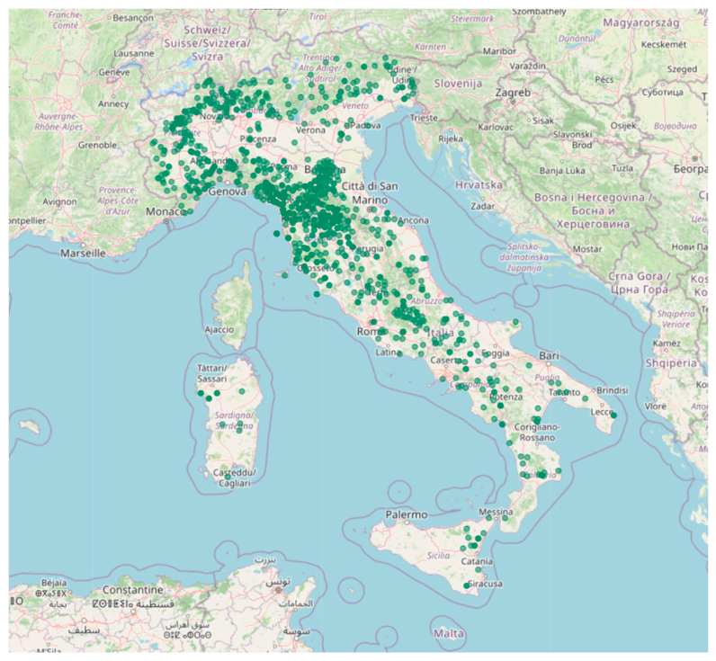
Figure 2.
Forest ownership and parcel-size structure. (A) Distribution of cadaster parcel areas, with mean and median parcel size indicated by vertical lines (B). Distribution of forest owners according to the total forest area owned. Bars represent the number of forest owners within each class of total forest area owned (ha), calculated as the sum of all parcels belonging to the same owner.
Figure 2.
Forest ownership and parcel-size structure. (A) Distribution of cadaster parcel areas, with mean and median parcel size indicated by vertical lines (B). Distribution of forest owners according to the total forest area owned. Bars represent the number of forest owners within each class of total forest area owned (ha), calculated as the sum of all parcels belonging to the same owner.
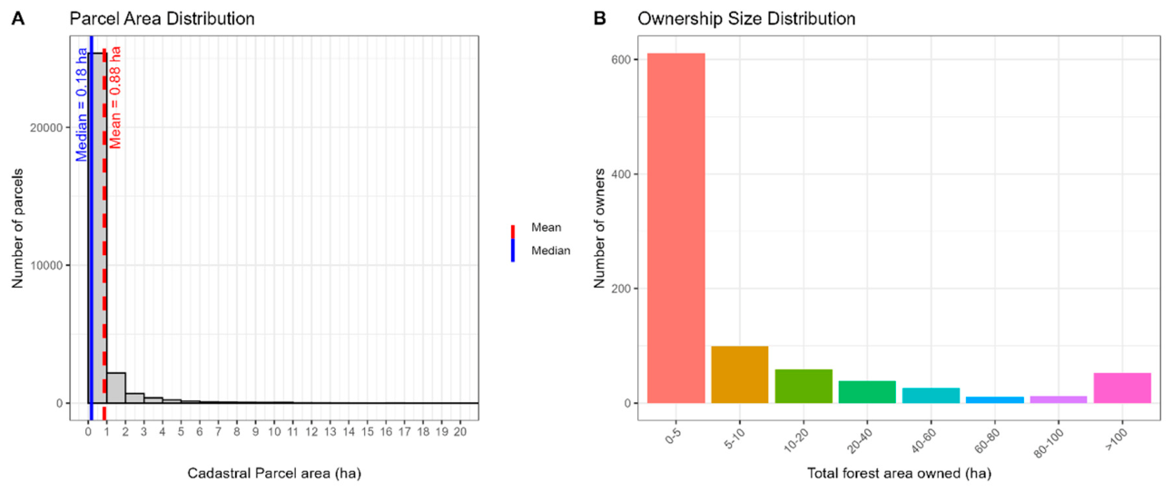
Figure 3.
Example of three forest management clusters identified using a maximum aggregation distance of 250 m of three clusters.
Figure 3.
Example of three forest management clusters identified using a maximum aggregation distance of 250 m of three clusters.
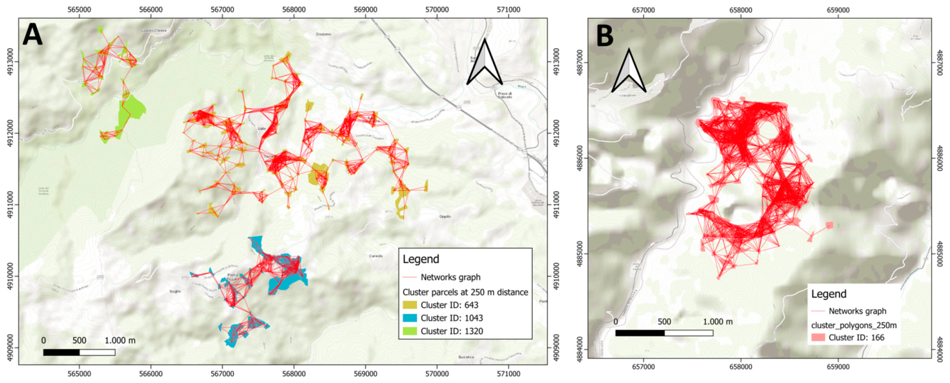
Figure 4.
Number of potential management clusters (A) and total aggregable forest area (B) under four spatial aggregation thresholds (100, 250, 500, and 1000 m). Potential management clusters were defined as aggregations including at least 30 ha of forest land and involving a minimum of two owners.
Figure 4.
Number of potential management clusters (A) and total aggregable forest area (B) under four spatial aggregation thresholds (100, 250, 500, and 1000 m). Potential management clusters were defined as aggregations including at least 30 ha of forest land and involving a minimum of two owners.
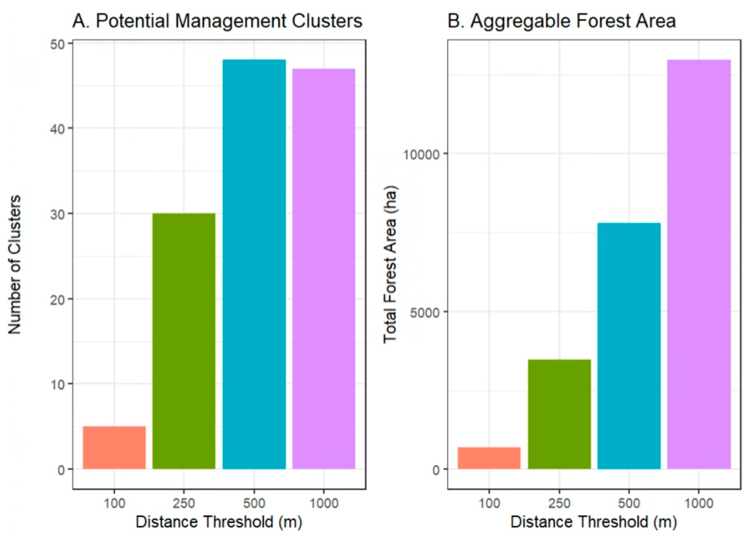
Figure 5.
Distribution of aggregable forest clusters across 10-ha area classes under four spatial aggregation thresholds (100, 250, 500, and 1000 m).
Figure 5.
Distribution of aggregable forest clusters across 10-ha area classes under four spatial aggregation thresholds (100, 250, 500, and 1000 m).
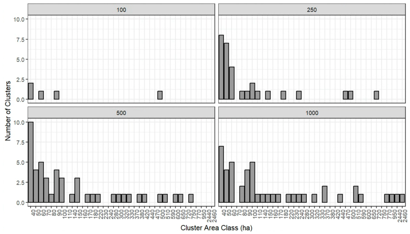
Figure 6.
Distribution of aggregable forest clusters by ownership class under different spatial aggregation scenarios (100, 250, 500, and 1000 m).
Figure 6.
Distribution of aggregable forest clusters by ownership class under different spatial aggregation scenarios (100, 250, 500, and 1000 m).
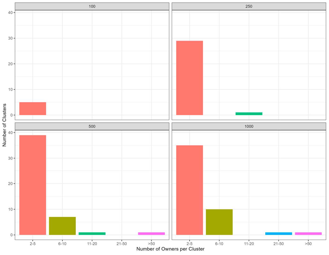

Table 1.
Main cadastral and land registration models in the European Union and their legal implications for property rights. The table was generated by direct interview with Forest Expert in different EU Countries.
Table 1.
Main cadastral and land registration models in the European Union and their legal implications for property rights. The table was generated by direct interview with Forest Expert in different EU Countries.
| Land Administration Model |
Legal Status of Ownership Information | EU Member States |
|---|---|---|
| Central European (Grundbuch-based systems) | Ownership rights are recorded in legally authoritative land registers with strong evidentiary or constitutive effect. Cadastral and registry information are closely integrated. | Austria, Germany, Czech Republic, Slovakia, Slovenia, Croatia, Hungary, Poland, Italy (Autonomous Porvices of Trento and Bolzano) |
| Nordic Integrated Systems | Integrated cadastral and land registration systems providing high legal certainty and comprehensive digital land information infrastructures. | Sweden, Finland, Denmark, Estonia, Latvia, Lithuania |
| Latin Cadastre Systems | Cadastre primarily serves fiscal and technical purposes, while ownership rights are established through separate land registry systems and registered deeds. | Italy, France, Spain, Belgium, Luxembourg |
| Mixed or Transitional Systems | Ongoing integration of cadastral and land registration functions, with varying degrees of legal effectiveness and institutional coordination. | Portugal, Greece, Malta, Cyprus, Romania |
Table 2.
Cluster-level indicators used to evaluate the effects of different aggregation thresholds.
| Category | Indicator | Description |
|---|---|---|
| Structural Indicators | Number of cluster | Total number of clusters generated under each aggregation distance scenario |
| Parcels per cluster | Number of cadastral parcels included within each cluster. | |
| Cluster area (ha) | Total area of each cluster expressed in hectares | |
| Ownership indicators | Owners per cluster | Number of owners represented within each cluster. |
| Forest resource indicators | Total forest area in aggregable clusters (ha) | Total forest area included in clusters considered suitable for aggregation |
Disclaimer/Publisher’s Note: The statements, opinions and data contained in all publications are solely those of the individual author(s) and contributor(s) and not of MDPI and/or the editor(s). MDPI and/or the editor(s) disclaim responsibility for any injury to people or property resulting from any ideas, methods, instructions or products referred to in the content. |
© 2026 by the authors. Licensee MDPI, Basel, Switzerland. This article is an open access article distributed under the terms and conditions of the Creative Commons Attribution (CC BY) license (http://creativecommons.org/licenses/by/4.0/).
Copyright: This open access article is published under a Creative Commons CC BY 4.0 license, which permit the free download, distribution, and reuse, provided that the author and preprint are cited in any reuse.


