

Submitted:
29 June 2026
Posted:
01 July 2026
You are already at the latest version
Abstract
Historic water infrastructure in cities has often been treated as a technical system, while its role in shaping urban form, spatial organization, and everyday life has received less attention. Focusing on the old city of Mardin, this study examines underground water infrastructure as a constitutive element of urban morphology in a settlement shaped by arid climatic conditions and steep topography. The study adopts a multi-scalar analytical approach combining QGIS-based mapping, LiDAR-based three-dimensional documentation of selected structures, archival research, field observation, and oral testimony. Street fountains, water elements associated with religious and public buildings, hammams, and wells were mapped in order to reconstruct the spatial logic of the historic system and its relation to the built environment. The findings show that Mardin’s gravity-based underground water system functioned as an urban-spatial infrastructure that shaped the distribution of water access, public nodes, architectural organization, and everyday practices across both public and private space. They also show that the transition to centralized modern water systems disrupted the integrated relationship between water, topography, and urban form, while rendering the social and spatial contexts of water increasingly obscure. The study argues that water in Mardin functioned as a key structuring element of urban morphology and everyday spatial practice, embedded in the historical relationship between infrastructure, topography, and the built environment.
Keywords:
historic water infrastructure
; urban morphology
; gravity-based water systems
; hydrosocial transformation
; spatial mapping
; Mardin
1. Introduction
Historic water infrastructures in cities were closely intertwined with topography, built form, and everyday life. Far from functioning as isolated technical systems, they shaped patterns of access, use, and spatial organization across both public and domestic settings. Underground water channels, together with connected above-ground structures such as fountains, wells, and hammams, played an important role in shaping both the physical and social structure of historic cities. Although this historically embedded relationship was profoundly altered by modern urbanization, the surviving traces of these systems still provide an important means of understanding how water once participated in the making of urban space.
The constitutive relationship between urban morphology and water infrastructure can be approached through the relationship between topography, routes of conveyance, public outlets, water-dependent buildings, and domestic water storage systems. Documenting these elements can reveal how water moved through the city, where it became accessible, and how it participated in the organization of public nodes, building interfaces, and everyday practices. Such a reading makes it possible to examine the now partially obscured spatial relationship between the urban environment and historic water infrastructure.
The historic city center of Mardin, situated on a steep slope overlooking the Mesopotamian plain in southeastern Turkey, offers a distinctive case in this regard. Closely shaped by arid climatic conditions and sharply inclined topography, its historic water system remained an active part of urban life until the centralized modern water network was introduced in the 1970s. During that period, access to water was mediated through street fountains and public structures such as mosques, madrasas, and hammams directly connected to the underground water system; and domestic elements including wells and cisterns. Although many of these fountains remain active, this infrastructure has lost its central place in urban life, and some of the underground channels have been disrupted by modern infrastructural interventions. Mardin’s historic water infrastructure can thus be read as an urban component that gave form to the settlement’s topographical order, spatial organization, and collective practices of everyday life.
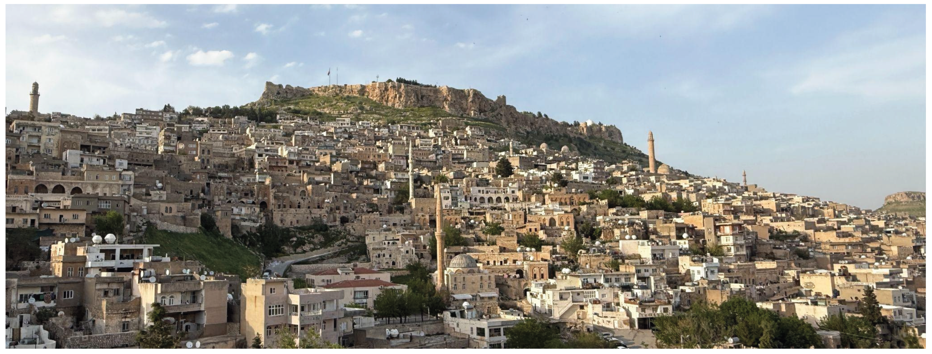
Figure 1.
A general view of the Old City of Mardin.
This study aims to document the historic underground water system of Mardin’s old city center and to examine how it contributed to the spatial organization of the historic urban fabric. Within this scope, water structures including street fountains; fountains and basins associated with mosques, külliyes, and madrasas; hammams; and street wells are mapped using Geographic Information Systems (GIS)-based technologies. Selected structures are documented through Light Detection and Ranging (LIDAR)-based three-dimensional recording techniques in order to analyze the relationship between underground channels, water outlets, built environment and topography. Archival research, field observation, and oral testimonies are evaluated in conjunction in order to reconstruct the partially obscured spatial logic of the historic system.
The study contributes to urban morphology and historic urban infrastructure studies by demonstrating how a decentralized, gravity-based water system shaped the distribution of water access, public nodes, architectural organization, and everyday practices in a steep and arid historic city. Rather than treating water infrastructure as a technical system external to urban form, the article reads fountains, wells, channels, hammams, cisterns, and other water-dependent buildings as spatial traces of an integrated urban system. It also shows that the transition to centralized modern water infrastructure altered not only water supply, but also the visibility, use, and local knowledge of the older system. More broadly, the case of Mardin demonstrates how historic water infrastructures can be analyzed as urban-spatial systems embedded in the relationship between topography, built form, and everyday life.
2. Conceptual Framework
The study draws on three complementary perspectives to interpret Mardin’s historic water system and its relation to urban morphology. The first situates historic water infrastructure within urban morphology by approaching underground channels, fountains, and water-dependent buildings as spatial traces that connect visible urban form to less visible infrastructural systems. The second uses studies of qanat and other underground gravity-based systems as a comparative analytical reference for understanding slope-based water movement, channel morphology, and the relationship between water infrastructure and settlement form in arid geographies. The third adopts a hydrosocial perspective in order to interpret how the transition to centralized modern water infrastructure altered the relationship between water, topography, urban space, and everyday practices.
2.1. Historic Water Infrastructure and Urban Morphology
In the historico-geographical tradition of urban morphology, urban form is commonly analyzed through the interrelation of streets, plots, buildings, and the historical processes through which these elements are produced and transformed (Conzen, 1960; Oliveira, 2016). In the context of historic water systems, this perspective makes it possible to ask how underground channels, shafts, outlets, fountains, and water-dependent buildings may have corresponded to, reinforced, or redirected the development of visible urban structures. Rather than treating underground infrastructure as external to urban morphology, this study approaches it as a hidden spatial layer whose traces can be read through the distribution of water outlets, street alignments, public nodes, and domestic water-storage systems.
Studies on ancient and pre-modern water systems show that elements such as wells, fountains, cisterns, hammams, and underground channels were often conceived in close relation to topography, urban and architectural form, and everyday practices (Angelakis et al., 2012; Hassan, 1998; Mays et al., 2007). In many historic settlements, water infrastructure took shape through local environmental conditions, building traditions, and collective forms of life, functioning not only as a technical supply system but also as a socio-spatial formation embedded in public and domestic space (Hamlin, 2000).
This perspective is especially relevant in arid and topographically complex geographies, where water systems often emerged through close adaptation to slope, geological conditions, and local knowledge (Mays, 2010a). The sewer and well networks integrated with street layout at Mohenjo-Daro (Jansen, 1989), the vertically organized cistern system of Matera (Mays, 2010b), and the slope-adapted water systems of Melukote (Ramineni & Bharadwaj, 2021) all illustrate the close relationship between water infrastructure, topography, and urban space.
Bonine’s study of Iranian cities is particularly relevant for interpreting the relationship between gravity-based water infrastructure, slope, and urban form. Discussing Yazd, he notes that the direction of qanats within the basin generally corresponds to the orientation of the city’s major streets, both being related to the slope of the land (Bonine, 1979). Alehashemi’s study of Semnan further develops this relationship by showing how traditional water distribution networks were integrated with urban morphology and socio-cultural structures. In Semnan, water infrastructure shaped the limits of residential quarters, the direction of main thoroughfares, the location of the city center and quarter centers, and the placement of main public functions (Alehashemi, 2020). These studies do not provide a direct typological model for Mardin, but they establish an important comparative basis for interpreting underground gravity-based water systems as possible morphological agents in arid and topographically constrained urban environments.
2.2. Underground Gravity-Based Water Systems as an Analytical Reference
Studies on underground gravity-based water systems, especially qanat-based systems in arid and semi-arid regions, provide a useful analytical reference for interpreting Mardin’s historic water infrastructure. Qanat (kehriz) systems, first developed in ancient Iran around the first millennium BCE and later disseminated across comparable geographies, remain one of the most significant historical examples of underground gravity-based water infrastructure (English, 1968; Ahmadi, Nazari Samani, & Malekian, 2010). These systems are characterized by subsurface water conveyance, the use of topographic slope for gravity-fed flow, and the presence of shafts or wells for access, ventilation, and maintenance (Figure 2). Their relevance here lies in the close relationship they establish between terrain, climate, settlement, and hydraulic practice.
For Mardin, qanat literature offers an analytical lens through which underground channels can be interpreted in terms of slope-based organization, channel morphology, possible construction techniques, and the means by which water may have reached the surface. The value of this reference lies not in establishing typological equivalence, but in clarifying the spatial principles through which water may have moved through the city and become embedded in the built fabric. In this study, qanat systems are therefore used as a heuristic framework rather than as a basis for direct comparison.
This interpretive reference gains further relevance from both regional and physical conditions. Mardin lies within Upper Mesopotamia, a historical corridor linking Persian geographies, the Levant, and the eastern Mediterranean, across which underground gravity-based water technologies are known to have circulated (Ahmadi, Nazari Samani, & Malekian, 2010). The hydrogeological structure of the Mardin anticline, with its north–south gradient and steep topography, also presents conditions compatible with gravity-fed subsurface water conveyance (UN-ESCWA & BGR, 2013). In this sense, underground gravity-based systems provide a productive reference for interpreting Mardin’s visible traces, including fountains, wells, outlets, and partially accessible channels, as parts of a spatial network shaped by slope, geology, architecture, and historical practices of use and maintenance.
2.3. Hydrosocial Transformation and Modern Infrastructural Rupture
This study is further informed by the hydrosocial perspective, which understands water not as a neutral technical resource, but as a socio-material process involved in the production of urban space, everyday practices, and social relations. Within this perspective, water systems help organize collective rhythms of life, shared practices, ritual uses, and regionally specific forms of social organization (Hamlin, 2000, cited in Linton, 2011; Swyngedouw, 2004).
Modern centralized water and sanitation systems, however, transformed this relationship. With the expansion of state-led hydraulic governance and networked urban infrastructure, water became increasingly abstracted from its ecological and cultural contexts and treated as a measurable technical resource. Swyngedouw describes this process as the “urbanization of water,” through which older localized water networks became progressively invisible in both physical and conceptual terms (Swyngedouw, 2004, 27). As a result, historic water infrastructures are often encountered only through fragmented traces such as fountains, basins, wells, and partially accessible channels, while the broader spatial relations that once connected them to urban life have become obscured. A similar process is described by Alehashemi in the Iranian context, where modern water infrastructures replaced traditional systems that had previously been integrated with urban morphology, socio-cultural organization, and local forms of water governance. From this perspective, the present study seeks to reconstruct the spatial relations through which water participated in the making of Mardin’s urban form and everyday life.
Modern centralized water and sanitation systems, however, transformed this relationship. With the expansion of state-led hydraulic governance and networked urban infrastructure, water became increasingly abstracted from its ecological, cultural, and topographical contexts and treated as a measurable technical resource. Swyngedouw describes this process as the “urbanization of water,” through which older localized water networks became progressively invisible in both physical and conceptual terms (Swyngedouw, 2004). A similar process is described by Alehashemi (2020) in the Iranian context, where modern water infrastructures replaced traditional systems that had previously been integrated with urban morphology, socio-cultural organization, and local forms of water governance. For the present study, the hydrosocial perspective is therefore used as an interpretive lens for understanding how the modernization of water supply in Mardin altered the relationship between water, topography, urban form, everyday practice, and local infrastructural knowledge.
3. Research Setting
This section outlines the environmental and historical context of Mardin’s old city in order to situate the spatial organization of its historic water infrastructure. Located on a steep south-facing slope overlooking the Mesopotamian plain in southeastern Türkiye, Mardin’s historic core developed in close relation to topography, climate, and the conditions of water access. The relationship between terrain, built form, and water therefore remains central to understanding the formation of the city’s historic urban fabric.
3.1. Physical and Environmental Setting
Mardin and its surrounding region lie on the northern edge of the Upper Jazira Basin, between the Tigris and Euphrates rivers, on the Derik–Mardin uplift, or Mardin anticline, at elevations ranging from approximately 1,000 to 1,254 m above sea level (UN-ESCWA & BGR, 2013). Although historically connected to the Tigris basin, the city itself was established at a marked distance from the river, on a steep topographic threshold beneath the commanding position of Mardin Castle at around 1,150 m above sea level. This elevated terrain, known geomorphologically as the Mardin Threshold, shaped the settlement’s terraced north–south development and its characteristic linear urban form (Sözer, 1984; Canpolat & Bozdoğan, 2019).
The region is characterized by a continental Mediterranean climate with hot, dry summers, high evaporation rates, and irregular rainfall. These conditions historically limited the reliability of surface water as a regular source of supply (Abou Zakhem, Al-Charideh, & Kattaa, 2017; UN-ESCWA & BGR, 2013). Under such conditions, access to sustainable underground water sources with minimal evaporative loss became essential for settlement. The mountainous topography of the Mardin region also forms an important recharge zone for the Jezira Tertiary Limestone Aquifer System. Rainfall and snowmelt infiltrate rapidly through fractured and porous karstic limestone and basalt formations, while regional groundwater follows a natural north–south gradient toward Mardin’s southern slopes and the plains beyond (Abou Zakhem, Al-Charideh, & Kattaa, 2017; UN-ESCWA & BGR, 2013). Seasonal valleys descending from the mountain further shaped routes of access to water, while the site’s massive limestone geology provided favorable conditions for carving cisterns and other storage spaces into the rock (Arslan & Karadoğan, 2007). Together, these climatic, topographic, and hydrogeological conditions made water storage, localized access, and gravity-based underground conveyance central to the physical logic of urban development in Mardin.
3.2. Historical Development of the Urban Fabric and Water Systems
Mardin developed as a defensive hill settlement on the southern slopes of the Mardin Threshold (Şümeysani, 1985, cited in Kozbe, 2022). Its urban fabric reflects successive Roman (64 BCE–395 CE), Byzantine (395–mid-seventh century), Artuklu (1102–1409), and Ottoman (1517–1918) phases, with the Artuklu period being particularly important in shaping the character of the present historic core. The city’s elevated position, its distance from major water bodies despite belonging to the Tigris hinterland, and its long-standing strategic importance along major trade and military routes contributed to the formation of a fortified settlement organized around the castle. As the city expanded southward in terraces, the steep topography and the chronic difficulty of securing water under conditions of altitude and scarcity made storage, controlled access, and staged distribution central to the logic of urban development.
Following the earliest settlement around the castle, urban development in Mardin expanded gradually southward in terraced layers (Figure 3). Because the steep topography made it difficult to transport water uphill, on-site storage became a fundamental principle of physical development. Under arid climatic conditions, systems for harvesting snow and rain were integrated into the built fabric, producing a spatial organization in which water was stored locally and conveyed step by step from higher to lower elevations. More broadly, advanced water systems based on channels and tunnels were already present in Mesopotamia from the Late Bronze and Early Iron Ages onward, later developing into more organized infrastructures in Antiquity and the Roman period (Oğuz-Kırca, 2024).
In Mardin, however, such engineering knowledge appears to have been reworked through small-scale, locally embedded solutions shaped by the severe constraints of topography. Beneath traditional houses lie cisterns and rainwater or snow wells, while snow windows, projecting stone gutters, and courtyard-based collection systems enabled the capture and storage of seasonal water (Yıldız, 2008; Yıldırım & Akın, 2020). Fountains and water basins located in semi-open spaces such as the eyvan (Eyvan: a semi-open, usually vaulted architectural space open on one side to a courtyard, characteristic of the regional building tradition and often used for circulation, gathering, and climatic comfort.) and revak (Revak: a semi-open, usually colonnaded architectural space running along a courtyard edge, characteristic of the regional building tradition and often used for circulation, shelter, and climatic comfort.) further supported domestic use and contributed to thermal comfort during the hot summer months. In this sense, the uncertainty and intermittence of water, rather than its steady continuity, became a key determinant of the multi-scalar solutions embedded in the settlement and of the spatial logic through which the city developed.
Regional precedents indicate that sophisticated water engineering was present in the wider landscape during the Roman and Late Antique periods. Nearby sites such as Dara and Zarzavan preserve evidence of large-scale storage, conveyance, and distribution systems, suggesting that knowledge of tunnels, cisterns, and other hydraulic structures circulated in the broader region (Akkurnaz & Çidem, 2025). For Mardin itself, however, direct evidence for the internal logic of water distribution in these earlier periods remains limited, and the most clearly legible phase in the present historic fabric belongs to the Artuklu period.
This is also the phase most clearly legible in today’s urban fabric (Çağlayan, 2017), when Mardin emerged as an important political and cultural center and the expansion of mosques, külliyes, madrasas, hammams, and street fountains required more structured forms of water provision. During this period, water infrastructure became institutionalized through monumental buildings while also spreading to the neighborhood scale through street fountains, creating a distributed system that supported the continuity of everyday life across the city.
The location of water-intensive buildings such as mosques and hammams along the descending paths of water flow from the castle and mountain suggests that they were positioned in relation to nodal points within a topography-adapted, gravity-based system of conveyance. Water in Mardin therefore functioned as more than a resource to be transported. It also operated as a spatial principle guiding the location of buildings, the relation between public and private space, and the organization of an infrastructural network composed of channels, clay pipes, cisterns, fountains, and bathhouses. Hammams are especially important in this respect, since they required systems of both supply and drainage. Their operation depended on a hidden but essential infrastructural logic capable of managing high water volumes, wastewater discharge, heat, and humidity (Mithen, 2017). Within külliye complexes, the co-location of hammams, fountains, madrasas, and other public structures intensified water-dependent functions and contributed to the formation of urban nodes. In this sense, Mardin’s water infrastructure developed as a fragmented yet interrelated system shaped by topography, climatic constraint, storage practices, public institutions, and historical habits of use. This infrastructural logic formed part of the city’s historical development and provides the basis for understanding the remaining traces analyzed in the following sections.
4. Materials and Methods
This study examines the spatial logic of historic water infrastructure in Mardin through a qualitative embedded single-case approach, working across multiple spatial layers including the urban fabric, underground channels, public and private water-related buildings, and modern interventions. Across these layers, the study combines QGIS-based mapping, morphological and sectional analysis, archival review, LiDAR-based three-dimensional scanning of selected structures, field observation, and oral testimony. Together, these methods are used to reconstruct the relationship between underground water routes, topography, urban morphology, architectural organization, everyday practices of water access, and modern infrastructural disruption.
Drawing on physical remains, material traces, field observation, and oral testimony, the research follows a spatial decoding approach informed by studies of historic water systems (Haut and Viviers, 2010). Rather than evaluating the system through quantitative hydraulic performance criteria, the study focuses on reconstructing its spatial logic: how water routes were organized, where water became accessible, how outlets and channels related to topography, streets, buildings, and public spaces, and how these relations were embedded in the historic settlement pattern.
The analysis was organized through five complementary readings. First, the mapped distribution of water-related structures was examined in relation to topography and the broader settlement pattern. Second, concentrations of fountains, hammams, mosque and madrasa outlets, wells, and domestic water elements were analyzed in order to identify clusters, public nodes, and public/private interfaces. Third, partially accessible underground channels were examined through their morphology, sectional logic, slope, dimensions, maintenance shafts, and relation to source and outlet points. Fourth, selected public and private buildings were analyzed to understand how water routes were integrated into architectural elements such as eyvans and courtyards. Finally, modern infrastructural interventions were examined in order to understand how pipe insertions, restoration works, covered shafts, inactive fountains, and centralized water supply have disrupted or obscured the spatial logic of the historic system.
Cases were selected purposively to represent different spatial conditions and varying degrees of integration between water infrastructure and the built environment. Selection criteria included the partial or full accessibility of underground channels, the visibility of the connection between channel and outlet, the presence of water-related architectural elements, and the capacity of the case to reveal relationships between water infrastructure and public or private space. Accordingly, ten buildings and fountains were included in the present study: Zinciriye Madrasa, Kasimiye Madrasa, Sehidiye Madrasa, the Old Post Office, the Old Surur Garage, House A, House B, and the Milliye, Melha, and Cevheriye fountains.
QGIS was used to map existing water outlets and to examine their distribution in relation to topography, streets, public buildings, and urban clusters. Archival review supported the identification and localization of additional water-related structures. LiDAR-based three-dimensional scanning produced high-resolution documentation of selected cases and enabled sectional reconstruction and comparative analysis of the geometric relationship between channels, outlets, basins, courtyards, and adjacent architectural elements. Oral testimony from an expert who had participated in the opening, maintenance, and repair of these routes, as well as in the construction of water outlets, provided a key interpretive source that complemented the spatial documentation. Additional testimony from local residents contributed case-specific knowledge. Rather than constituting a full ethnographic component, these interviews were used as verbal accounts that helped confirm household- and neighborhood-scale connectivity predating modern infrastructure and made some now-invisible physical links analytically legible.
The study is subject to certain limitations. Because the analysis is based on a limited number of documented cases, partially accessible underground routes, and oral testimony from key informants, it does not aim to reconstruct the entire underground water network in exhaustive technical detail. Instead, the methodology is designed to reveal the spatial logic of the system through the combined reading of material traces, mapped distributions, sectional documentation, field observation, and situated infrastructural knowledge.
5. Analysis: Spatial Logic of Mardin’s Historic Water Infrastructure
This section examines the spatial logic of Mardin’s historic water infrastructure across five interrelated readings: urban distribution, clustering and public/private interfaces, channel morphology, architectural integration, and modern infrastructural disruption. Because the underground channels are only partially visible today, the analysis reconstructs the system through a combined reading of mapped water outlets, topography, channel traces, maintenance wells, building-scale water sequences, field observation, and expert testimony. The first subsection examines the distribution of fountains, hammams, mosque and madrasa outlets, wells, and domestic water elements in relation to topography and settlement morphology. The second analyzes clustering, urban centrality, and public/private interfaces. The third turns to the morphology and sectional logic of the channels themselves. The fourth examines how water routes were integrated into public buildings and private houses, showing how infrastructure became embedded in architectural organization and everyday use. The final subsection addresses modern infrastructural disruption and the ways in which centralized water supply, restoration works, pipe insertions, and the loss of local maintenance practices have obscured the spatial logic of the historic system.
5.1. Mapping the Urban Distribution of Water Infrastructure
A total of forty-two water-related structures were recorded and mapped in situ. These include twenty-one street fountains, eighteen public-building outlets (eight mosque outlets, two külliye outlets, three madrasa outlets, one old garage fountain, one passage fountain, one tekija fountain and two hammams), and three private house water outlets (Figure 4) (Table S1 and Figure S1). With the exception of four street fountains, all documented water elements remain active today. The mapped distribution suggests that water-related structures were not randomly dispersed across the old city, but concentrated in particular areas. The highest concentration appears in the Medrese and Teker neighborhoods, which also encompass the heart of the historic bazaar. By contrast, in the western parts of the old city, including Çabuk and Diyarbakırkapı, and in Yenikapı to the south, no comparable water elements could be documented. This uneven distribution suggests that the central bazaar zone and its surrounding neighborhoods were more closely associated with the underground water system than other parts of the historic settlement.
Topography appears to have played a significant role in the organization of the system, reflecting the logic of gravity-fed water movement across Mardin’s steep terrain. According to expert testimony, each underground water channel was typically constructed to supply a single outlet rather than forming part of an interconnected network. This suggests a decentralized hydraulic system in which seepage or spring water was captured at the göze (Göze is the term used to describe the spot where surface water springs up from the ground.) and directed downslope toward individual outlets through gravity. In this respect, the system can be understood as an adaptation to sloping terrain, comparable in principle to qanat-based water systems in other steep and drought-prone geographies. The channels appear to have transported water along efficient slope-based routes to points where it approached the surface and became accessible through fountains and other outlets.
5.2. Clustering, Urban Centrality, and Public/Private Interfaces
The mapped distribution also suggests a reciprocal relationship between water infrastructure and urban morphology. Four clusters can be identified in the concentration of water-related structures, and all correspond to areas of significant public activity and institutional presence (Figure 5). According to expert testimony and archival review, larger water outlets such as those associated with mosques, madrasas, and hammams were generally located where access to underground water was strongest or most reliable. The location of hammams, in particular, as major nodes of both water inflow and outflow, further suggests a close relationship between public architecture and access to groundwater.
Cluster 1, encompassing the Medrese and Teker neighborhoods and the historic bazaar, contains the highest concentration of water elements, including major structures such as Ulu Cami, Sehidiye and Zinciriye Madrasas, Emir Hamamı, and twelve street fountains. Since water in Mardin was likely conveyed from nearby sources along efficient routes rather than emerging directly at outlet points, the clustering of major water structures in this area suggests a strong relationship between water availability, public architecture, and the formation of urban centrality. This interpretation is further supported by the identification of the short water channel at Old Surur Garajı and by House 2, which includes interior gözes within the same cluster. Ayn Tumbaga and Zinciriye Madrasa fountains also appear likely to have been fed by relatively short channels, given their proximity to the mountain top. Taken together, these observations suggest that this zone may have had especially favorable access to underground water, which may in turn have contributed to the historical development of the bazaar in this area.
Clusters 2 and 3 similarly include water structures embedded within major public buildings. The concentration of mosques, madrasas, and hammams in these clusters suggests that larger water outlets contributed to the formation of public nodes, even where the density of street fountains is lower. In Savurkapi, Cluster 4, by contrast, the density of street fountains points to a more localized and street-based distribution. Street fountains, in particular, appear to have supported the formation of small public enlargements and nodal spaces along circulation routes. Rather than functioning merely as technical endpoints, these outlets helped structure the relationship between movement, gathering, and access to water in everyday urban life.
Some of the street fountains are categorized by Yıldız (2008) as freestanding public square fountains (Figure 6), five of which were documented in this study. Their location within the urban fabric demonstrates the close relationship between water and public-space formation. Adapting to the topography-based spatial logic of the city, these fountains often occupy circulation nodes and contribute to the emergence of small public gathering spaces. Milliye and Cevheriye fountains are distinctive in this respect. Both located at the junction of several alleys, Cevheriye Fountain generates a public gathering space directly in the front (Figure 7), while Milliye Fountain is embedded between two public openings at different levels (Figure 8).
Beyond the freestanding fountains that define small public squares, most street fountains in Mardin are integrated either into buildings or into water routes running immediately below street or courtyard level. This indicates that street fountains were not uniformly conceived as independent urban objects, but often formed part of a more closely embedded relationship between water infrastructure, architecture, and topography. Among the mapped examples, Ayn Yahud, Ayn Tumbaga, Sultan İsa, House C, and Bab-ı Sor fountains are incorporated directly into building fabric (Figure 9), while Kiseyri, Pınarbaşı, and Seyh Imamettin fountains are positioned just below courtyard or street level. In some cases, access to water requires descending below ground level by stairs, as in the fountains of Teker Mosque and Ayn Tumbaga. These level differences suggest that the points at which water emerged were determined not only by architectural placement but also by the vertical logic of the terrain and the subterranean routes through which water approached the surface. According to oral testimony, such fountains were used not only for household water supply but also for irrigating private or shared gardens. In this sense, embedded fountains reveal how water infrastructure shaped everyday access across the interface of street, courtyard, house, and garden.
A further dimension of this relationship can be seen in the partial correspondence between underground water routes and alley alignments. Along the route leading to Sehidiye Madrasa, seven of the eleven maintenance wells are aligned at intervals of approximately 35-40 m along Sönmezler 255 Sokak. Although the well openings are now covered by modern pavement, they remain accessible for maintenance. Three of these wells remain in two houses, one of which is documented (Figure 10). According to expert testimony, in dry periods these wells were also used by local residents to access water. In this sense, water infrastructure can be understood as an active component in the formation of both monumental and ordinary public space within Mardin’s historic fabric.
5.3. Channel Morphology and Sectional Logic
At the level of the underground channels, the most consistent feature of the system is the presence of individual routes extending from a source to a specific outlet. The available spatial evidence and expert testimony indicate that these channels generally operated as separate routes rather than as parts of an interconnected network. The main exception appears to be the channel shared by the Emineddin Külliye and the nearby Maristan Fountain, where the route branches shortly before reaching the fountain.
According to expert testimony, channel lengths range from approximately 20 m to 430 m. The shortest documented example is at Surur Garajı, while the longest supplies Sehidiye Madrasa. Channel dimensions also vary considerably. The Kasimiye Madrasa channel appears to be among the widest and highest sections accessible from building entrances, with a documented width of approximately 140 cm and, in some places, a height reaching 3 m. By contrast, sections from the Sehidiye channel narrow to as little as 40 cm. Although the channels are said to remain accessible as far as the source cave, the present study was able to document only the first 4–5 m of the routes at building entrances for safety reasons.
The channels do not follow strictly linear routes from source to outlet. They proceed through angled and shifting paths shaped by topography and hydraulic requirements (Figure 11). According to expert testimony, they were constructed partly by carving into the limestone substrate and partly by masonry construction where necessary. No single standardized form can be identified. Some sections approach a rectangular profile, others appear more oval, and some are markedly irregular (Figure 11). Evidence from the Surur Garajı channel suggests that the points of origin were cave-like cavities from which the channels began.
Along each route, wells or shafts provided access for maintenance and, in some cases, for drawing water from above. Their similarity to qanat-type construction logic suggests that they may also have been opened during the initial excavation process. In many cases, especially where they align with streets, they appear to have served as points of public access. According to expert testimony, shallow basins were located beneath some of these wells, allowing water to accumulate and be extracted.
The channels reach their outlets through routes determined by slope. Scan data suggest that the points at which channels meet buildings are usually angled, likely allowing adjustment of gradient and flow velocity in relation to topography. Based on the Sehidiye Madrasa route traced in the QGIS data, the channel slope can be estimated at around 5 percent, descending approximately 15 m over a length of 290 m. Measurements taken at building entrances indicate considerable variation, with some sections, such as the channel reaching Zinciriye Madrasa, appearing to approach 20 percent. These differences suggest that channel inclination was determined by the relation between source location, building position, and the constraints imposed by topography.
5.4. Architectural Integration and Everyday Water Use
The selected cases reveal different ways in which underground water infrastructure was integrated into the built environment. Read comparatively, they show that water was not an external infrastructural addition, but a structural component embedded in both public and private architecture. Wells, fountains, basins, and pools shaped spatial organization, circulation, and the use of architectural elements such as the eyvan and courtyard. Across these cases, water emerges as a constitutive element of architectural form and everyday life.
5.4.1. Water Organization in Monumental Architecture
In the documented monumental structures, including külliyes, madrasas, and mosques, water occupies a central place within the architectural composition. Sequences extending from underground channel to storage, fountain, and basin are integrated into the organization of eyvan and courtyard spaces. As a semi-open threshold characteristic of the region’s building typology, the eyvan frequently marks the point at which source water enters the building and becomes architecturally legible.
In most of the monumental structures documented in this study, source water enters the building through fountains. In mosques, the fountain and its first associated basin are generally located in the eyvan. In Sehidiye, Zinciriye, and Kasimiye madrasas, larger courtyard basins receive the water conveyed from the eyvan, producing a more extended sequence of water elements within the continuity of the eyvan–courtyard arrangement. At this scale, water contributes to the microclimatic quality of the eyvan while also functioning as a spatial reference that helps structure movement, orientation, and everyday use within the building.
Zinciriye Madrasa offers one of the clearest examples of the relation between water sequence and architectural arrangement. Water arriving through the channel first reaches a storage space at the upper building level, then continues to the ensemble formed by the eyvan fountain, the first basin, and the larger courtyard pool located one level below (Figure 12). The movement of water does not end in the eyvan and courtyard but continues to the street-level fountain outside the building. Zinciriye thus contains a continuous sequence of water structures, including channel, storage, fountain, basins, and street fountain, all embedded within the architectural continuity of eyvan, courtyard, and street.
A similar arrangement appears in Sehidiye Madrasa, where the channel enters the building through the fountain and is incorporated into the eyvan–courtyard sequence (Figure 13 and Figure 14). Kasimiye Madrasa follows the same structural and architectural logic (Figure 15). In these cases, the relation between the eyvan, courtyard, fountain, and connected basins produces a spatial setting in which water is experienced as both a sensory and climatic presence within a hot, dry environment.
Other than madrasas, public buildings generally do not include large courtyard pools. In mosques such as Ulucami, Latifiye, Melik Mahmut, and Teker, the water arrangement is organized around a central eyvan, where the fountain and its first small basin are located before the water continues toward a street fountain. In other cases, including Seyh Cabuk, Salsal, Kuseyri, Latifiye, and Pinarbasi mosques, as well as the Emineddin and Necmeddin külliyes water appears in more compact forms, as fountains set into the building wall, as street fountains positioned just below courtyard level, or as ablution area fountains. These cases indicate a consistent relation between source water and the street-facing fountain, whether the connection is direct or mediated through the fountain in the eyvan.
The architectural centrality of water in public buildings extends into the social life of the city. Beyond situations in which water had to be carried from these buildings and from street fountains for drinking and everyday use, fountains in mosques and madrasas acquired a distinct public significance through ablution as a ritual practice. In some public buildings, pools also assumed functions that exceeded their structural and climatic role. The pool in Kasimiye Madrasa, for instance, is known to have served as a surface through which the movement of the sky was observed during astronomy lessons.
This degree of centrality does not characterize all public buildings in the same way. In structures such as garages and passages, where water use was less integral to the building’s primary function than in mosques, madrasas, or hammams, water appears in a more limited and utilitarian form. In Kayseriye Passage, for example, source water is made available primarily to shopkeepers through fountains in a rear section of the building. In Old Surur Garajı, although a short underground channel provides direct access to source water, it is used after collection in a well rather than being conveyed through a fountain (Figure 16). In the Old Post Office, which has no direct access to source water, use is organized through a cistern immediately beneath the courtyard and a well that provides access to it (Figure 13). According to building users, the cistern is fed by water filtering through the ground.
5.4.2. Water Access and Storage in Private Buildings
Unlike monumental buildings, only a limited number of houses in the settlement appear to have had direct access to source water. Domestic water use varied according to the location of the house and, in some cases, the social status of its occupants. Most houses did not have direct access to the source itself, and water for everyday use was generally brought from public fountains. According to expert testimony, approximately twenty houses in the old city center once had direct access to source water.
In some private residences, however, the relationship between water structures and architectural elements recalls the arrangements observed in monumental buildings. Firdevs Kasrı, built as the summer residence of an Artuqid ruler, reproduces on a smaller scale the sequence of fountain, small basin, and larger pool within the eyvan and courtyard. A comparable arrangement appears in House A, documented within the scope of this study, where source water reaches the house through an underground channel, emerges through a fountain and, with its connection to two small basins, forms the spatial center of the eyvan (Figure 17). As in the public buildings discussed above, water here occupies a central visual, acoustic, and climatic role. Before the later incorporation of the modern kitchen as a separate room, cooking, shared meals, and tea and coffee gatherings were organized around the pool in the eyvan. Water thus functioned not only as a domestic resource but also as a spatial and sensory element structuring everyday life.
House A also contains a well. Although this well is not physically connected to source water, its location is likewise related to the eyvan. Rainwater and snowmelt stored in the well were used for cleaning and laundry, while drinking water was generally supplied from source water. The remaining rooms of the house open onto the eyvan, indicating that the principal circulation space and the primary sphere of domestic life were organized around this semi-open space and in direct relation to water.
In the adjacent house, House C, on the same street, by contrast, the source emerges without an eyvan-fountain-pool sequence, appearing instead as five separate gözes rising from the ground in the rear develik (Especially in Southeastern Anatolia, develik is the space, located at the ground floor of traditional stone houses, where camels or other pack animals were kept.) room. The street fountain located at a lower level beside the garden wall also appears to be connected to this same source.
In some houses located directly on a channel route, especially where maintenance wells coincided with the building, source water could be accessed directly through these wells. In houses and buildings without such access, independent bell-shaped rain and snow wells, sometimes connected to cisterns, formed the principal internal water system. Roof drainage was directly connected to these wells, allowing rainwater to be collected with minimal evaporative loss. During snowy periods, snow was also gathered in these wells and in the ventilation shafts aligned with the streets. These variations indicate that domestic water provision in Mardin ranged from direct access to source water to systems based primarily on the storage of rain and snow, with corresponding differences in household spatial organization.
5.5. Modern Infrastructural Disruption and the Obscuring of Spatial Logic
Although many of Mardin’s fountains remain active, the historic water system as a whole has been partially obscured by modern infrastructural interventions. Underground channels have in some cases been clogged, interrupted, or replaced by inserted pipes, while maintenance wells have been covered by paving or absorbed into later buildings, reducing the legibility of the original routes. These transformations have not only altered the technical functioning of the system but have also weakened the visible and everyday relationship between water, urban space, and collective use.
The condition of the fountains and channels themselves illustrates the extent of this disruption. Although the exact number of dried fountains across the old city cannot be established with certainty, three of the twenty street fountains mapped in this study were found to be inactive. According to expert testimony, a total of eight fountains are no longer functioning because their main sources have dried up, and structural collapses at multiple points along the channel system have further interrupted the continuity of the older network.
In some cases, fountains have become unusable because sewage leakage contaminated their source channels. At Sehidiye Madrasa, for example, contamination of the water reaching the eyvan fountain led to the installation of a 430 m PVC pipe along the main tunnel in order to reconnect source water directly to the fountain. Elsewhere, source waters have reportedly been diverted through newly installed pipes to different locations, disrupting the original route and, in some cases, restricting public access.
Infrastructure and restoration works in the historic urban fabric have further contributed to the interruption and reduced visibility of the old system. Because the historic network is no longer treated as an active component of water supply, it is often not considered in restoration or infrastructure projects. As a result, fountain connections have been closed, while wells and cisterns have been filled in or left inactive. The Zinciriye Madrasa lower-level fountain illustrates this process clearly. According to expert testimony, water that once continued from the eyvan pool to the lower street fountain was rendered inoperative during restoration works. Public access formerly provided through the street fountain was thus eliminated. Subsequent road works left the now-dry fountain below the new street level, turning it into an abandoned residual space.
Wells and cisterns, once the principal structures for water storage and use in both public buildings and private houses, have likewise become largely obsolete. Restoration works and changing domestic practices have severed the former connection between roof drainage and these storage systems. In some cases, wells remain in use only because modern network water is fed directly into them and then redistributed within the building by hydrophore systems. Water use is therefore no longer organized through the cyclical collection of rain and snow or through direct access to source water, but through a one-directional centralized network with limited physical accessibility. As a result, the spatial arrangements and social practices once organized around direct access to water have become progressively less visible.
A similar process has affected the ventilation and access shafts associated with the underground channels. These shafts are known to have functioned not only for maintenance and ventilation but also as a means of returning rainwater and snowmelt to the broader water system. Road works have sealed many of them with stone paving, while others have fallen within private property boundaries and lost their original function through later reuse.
The modern water network, by contrast, operates independently of the historic system. Water is now conveyed from Beyaz Su, a river source located approximately 70 km from Mardin’s city center, through newly installed pipes and pumped to storage depots before being distributed to the neighborhoods of the old city. Because supply reaches the historic center only two days a week, domestic water is now stored in metal or PVC tanks installed on the rooftops of nearly every house, replacing wells and cisterns as the principal storage system. These rooftop tanks have become visible components of the historic urban landscape and have altered the silhouette of the old city (Figure 18). As a result, the continuously flowing historic system has progressively lost its function, while the city has become dependent on an intermittent centralized supply. The transition from the historic system to the modern one therefore involved more than a technical replacement of infrastructure: it also altered the visibility of water in the city and transformed the visual character of the historic settlement.
6. Discussion
The analysis shows that Mardin’s historic water system operated as a socio-spatial infrastructure that shaped urban morphology, architectural organization, and everyday practices across multiple scales. The discussion develops this argument in three parts. The first examines water infrastructure as an urban-spatial system through which access, movement, public nodes, architectural arrangements, and social practices were organized. The second discusses the decentralized hydraulic logic of the system and its relationship to topography, channel morphology, and urban form. The final part addresses the forms of disruption produced by modern infrastructural transformation, focusing on the loss of spatial continuity, everyday visibility, and local knowledge associated with the historic water system.
6.1. Water Infrastructure as an Urban-Spatial System
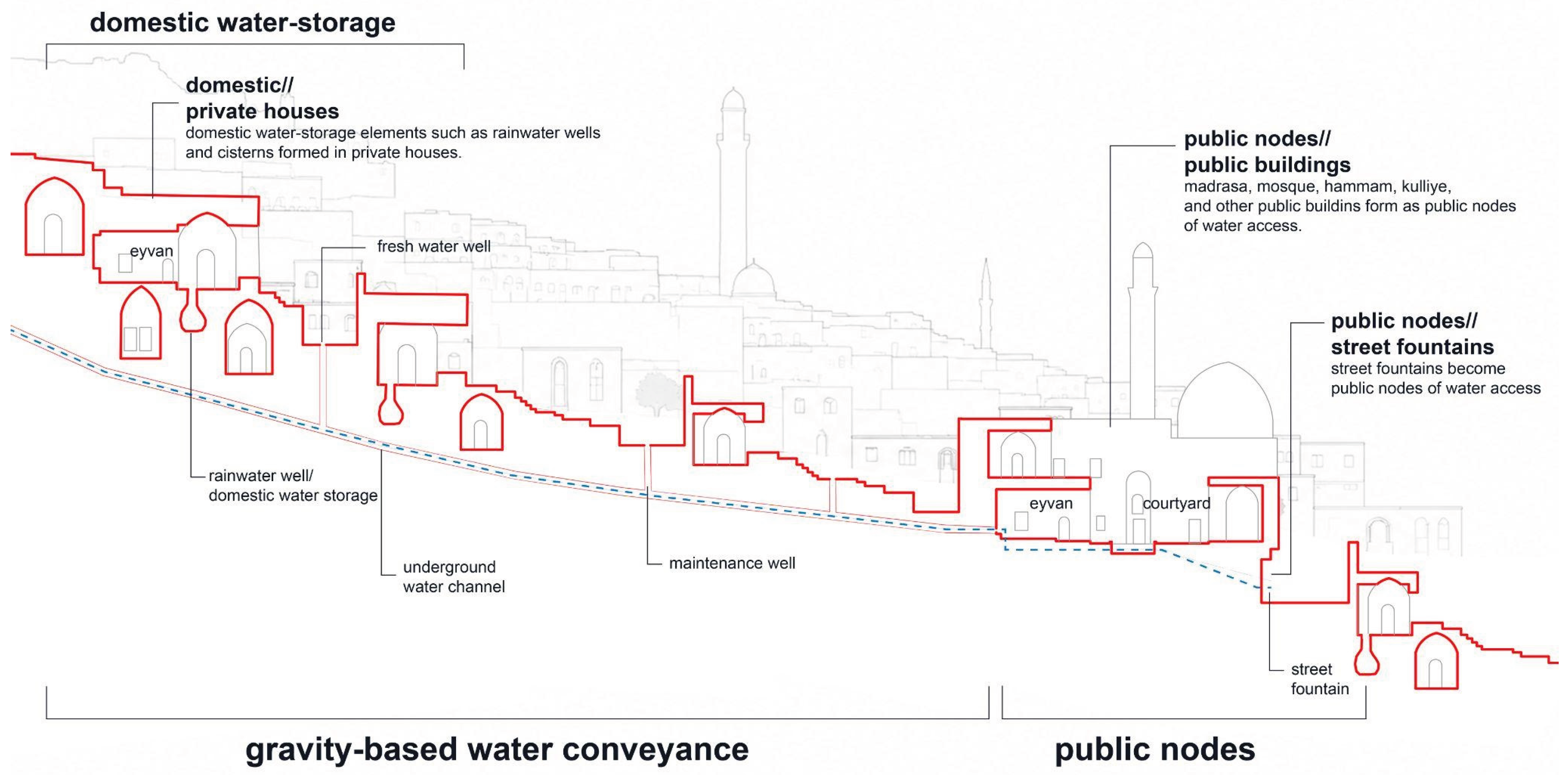
The case of Mardin demonstrates how historic water infrastructure operated as an urban-spatial system embedded in the formation of the built environment and everyday life. The water network identified in this study formed part of a socio-material organization through which water became accessible at specific points in the city, generating public nodes, clusters of water-dependent buildings, and interfaces between streets, public buildings, private houses, courtyards, and eyvans (Figure 19).
Water elements were therefore integrated into the urban and architectural fabric in ways that shaped spatial hierarchy, circulation, climatic adaptation, and social practice. Fountains, basins, wells, channels, and pools formed embedded components of the built environment through which public access, ritual use, domestic routines, and embodied practices were materially organized. In this sense, water operated as a structural medium linking urban morphology, architectural organization, and everyday life across multiple scales.
This multi-scalar integration is visible in the way water routes connected underground channels, outlets, public spaces, and building interiors. Zinciriye Madrasa offers a clear example in this regard. Water arriving through the underground channel was first collected in an upper-level storage space, then conveyed to the fountain in the eyvan, distributed to the courtyard pools, and finally directed toward the street-level fountain. This sequence organized a spatial continuity between interior, courtyard, and street, linking architectural use to public access and urban circulation.
6.2. Decentralized Hydraulic Logic and Urban Morphology
In Mardin, the natural slope of the terrain, together with a likely body of local hydraulic knowledge, enabled a gravity-based water system that operated through decentralized points of access and distribution. The system appears to have functioned through multiple routes that brought water to the surface at different locations across the settlement. This pattern of localized emergence played a significant role in shaping the spatial distribution of public buildings and water-related structures. It is especially visible in the clustering of major public buildings such as Emir Hammam and Zinciriye and Sehidiye Madrasas within areas of concentrated water access identified in the mapping analysis, where numerous fountains and other water outlets mark points at which subsurface water became accessible at the surface.
The points at which underground channels intersected with the topographic gradient and approached the surface appear to have been especially important in the siting of madrasas, hammams, mosques, and street fountains. These structures were spatially organized in relation to access to water and, together with the neighborhood fabric that developed around them, became significant components of urban morphology. The historic water system can therefore be understood as a spatial infrastructure through which the relationship between settlement, topography, and water was materially expressed.
The traces of underground water circulation observed in Mardin’s historic urban fabric, together with wells and water-related spatial arrangements, reveal a topographically adapted system of gravity-based channels and vertical shafts. Although this configuration does not correspond exactly to the classical qanat model, it suggests a local adaptation shaped by comparable hydraulic principles. This reading is supported by the vertical access points and fragmented channel traces documented across the study area, which indicate a system of wells and sloping channels adapted to the steep topography of the settlement. In terms comparable to Jayasena and Gangadara’s (2014) notion of “parallel evolution,” the system appears to have developed in close relation to settlement patterns and to have produced a hybrid infrastructural logic specific to its geography.
The Mardin case also suggests that the relationship between water infrastructure and urban morphology cannot be understood only through planimetric analysis. In a steeply sloping settlement, the spatial logic of water operates through section as much as through plan. The verticality of wells and shafts, the inclination of underground channels, the terracing of buildings and streets, and the emergence of water at different levels together produce a three-dimensional infrastructural morphology. This sectional dimension is central to understanding how water, topography, and built form were integrated in Mardin.
6.3. Modern Infrastructural Rupture and Hydrosocial Disconnection
The transition to modern water infrastructure disrupted the spatial continuity of local water networks in historic cities and rendered them increasingly invisible. In the process described by Swyngedouw (2004, 27; 2015) as the “urbanization of water,” water is detached from its local context and reorganized as a centralized technical circulation system. As this transformation advances, local knowledge and everyday experience related to water also begin to erode.
In Mardin, the historic system operated through a spatial logic that was topographically adapted, low-energy, and climatically effective. By contrast, the centralized modern network has largely eliminated this spatial and environmental logic. Water use has shifted from a direct and spatially embedded practice to an indirect and mediated one organized through closed systems. Public forms of access once structured around fountains and wells have largely disappeared, while local practices such as rainwater harvesting, snow storage, and the organization of daily routines around water have gradually been lost. In this respect, Linton’s (2011) notion of “disconnection” provides a useful framework for understanding the weakening of the physical and experiential relationship between water and everyday life.
This shift to externally supplied, pumped, and intermittent water has replaced a topography-adapted and locally embedded system with one that is more energy-dependent and infrastructurally fragile. It has also introduced a new spatial logic, in which rooftop storage becomes a visible sign of centralized scarcity rather than locally organized water access.
At the same time, knowledge of the historic system has become increasingly concentrated in individual memory. The fact that the maintenance and interpretation of the old water infrastructure now depend heavily on a single knowledgeable individual reveals the fragility of both the physical system and the knowledge that once sustained it. What is at stake, therefore, is not only the loss of a material infrastructure, but also an epistemic rupture in the transmission of the practices, techniques, and spatial understanding through which that infrastructure once functioned. The shift to a centralized and intermittent modern water network has thus obscured not only the material traces of Mardin’s historic water system, but also the local knowledge required to interpret, maintain, and transmit its spatial logic.
7. Conclusions
This study has examined the underground water infrastructure of Mardin’s historic urban fabric as a socio-spatial component that shaped urban morphology and everyday life as well as architectural organization. The analysis shows that water was distributed through a topography-adapted, gravity-based, and decentralized logic, and that it operated in close integration with architectural organization in both public and private buildings. Access to and use of water therefore formed a constitutive part of the city’s spatial organization.
By reconstructing this spatial logic, the study also shows that the relationship between water infrastructure and urban morphology in Mardin cannot be understood only through planimetric analysis. In a steeply sloping historic settlement, water operated through a three-dimensional spatial system. The case of Mardin therefore highlights the importance of sectional analysis for understanding how historic infrastructures shaped the relationship between topography, built form, and everyday urban life.
With the transition to modern infrastructure systems, the integrated relationship between the historic water system, the city, and everyday life was significantly disrupted. Water was detached from its local, topographic, and social context and reduced to a centralized technical service. This transformation involved not only a physical change in infrastructure, but also the gradual erosion of the spatial knowledge and lived experience associated with water. As the circulation of water in the city became increasingly invisible, the spatial logic of the historic system and the knowledge that once sustained it became fragmented and fragile.
This transformation also points to a broader epistemic rupture, in which locally transmitted forms of hydraulic knowledge, maintenance practice, and community-based water use were displaced by centralized systems that are less visible and less legible to everyday users. In Mardin, the loss of local knowledge is especially critical because the historic system can now be interpreted only through fragmented material traces, partial access to channels, and the memories of a limited number of knowledgeable individuals.
In this respect, Mardin offers a distinctive case through which the transformation of historic water infrastructure under modern urbanization can be understood with particular clarity. The surviving traces of its historic water system make it possible to reconstruct the relationship between water, topography, spatial organization, and everyday practice. By documenting this spatial logic, the study contributes to the literature on traditional water systems, urban morphology, and hydrosocial transformation, while also underscoring the need to preserve and reassess the spatial and technical knowledge embedded in such systems.
Author Contributions
Conceptualization, Z.A., Y.A. and Z.T.; Methodology, Z.A., Y.A. and Z.T.; Software, Z.A.; Formal analysis, Z.A. and Y.A.; Resources, Y.A. and Z.T.; Data curation, Z.A.; Writing – original draft, Z.A., Y.A. and Z.T.; Writing – review & editing, Z.A., Y.A. and Z.T.; Visualization, Z.A. and Y.A. All authors have read and agreed to the published version of the manuscript.
Funding
This research received no external funding.
Data Availability Statement
The original contributions presented in this study are included in the article/supplementary material. Further inquiries can be directed to the corresponding author(s).
Conflicts of Interest
The authors declare no conflicts of interest.
References
- Abou Zakhem, B.; Al-Charideh, A.; Kattaa, B. Using principal component analysis in the investigation of groundwater hydrochemistry of Upper Jezireh Basin, Syria. Hydrol. Sci. J. 2017. [Google Scholar] [CrossRef]
- Ahmadi, H.; Nazari Samani, A.; Malekian, A. The Qanat: A living history in Iran. In Water and sustainability in arid regions: Bridging the gap between physical and social sciences; Schneier-Madanes, G., Courel, M.-F., Eds.; Springer, 2010; pp. 125–138. [Google Scholar] [CrossRef]
- Akkurnaz, S.; Çidem, M. Roma Dönemi’nde kentsel üretimde su gücünün kullanımı [The use of water power in urban production during the Roman period]. Aydın Adnan Menderes Univ. J. Inst. Soc. Sci. 2025, 12(1), 152–175. [Google Scholar] [CrossRef]
- Alehashemi, A. Water infrastructures and urban structures in Iran: Rethinking multidimensional integration. In Water & city: Hydraulic systems and urban structures; Alehashemi, A., Coulais, J.-F., Hubert, G., Eds.; Éditions L’Œil d’Or, 2020; pp. 259–269. [Google Scholar]
- Angelakis, A. N.; Mays, L. W.; Koutsoyiannis, D.; Mamassis, N. Evolution of water supply through the millennia; IWA Publishing, 2012. [Google Scholar]
- Arslan, H.; Karadoğan, S. Mardin şehrinin situasyonu ve yer seçiminde etkili olan coğrafi faktörler [Geographical factors affecting the location and site selection of the city of Mardin]. In Makalelerle Mardin II: Ekonomi-nüfus, kentsel yapı; Özcoşar, İ., Ed.; 2007; pp. 205–232. [Google Scholar]
- Bonine, M. E. The morphogenesis of Iranian cities. Ann. Assoc. Am. Geogr. 1979, 69(2), 208–224. [Google Scholar] [CrossRef]
- Canpolat, E.; Bozdoğan, M. Be yazsu Havzası’nın (Mardin) flüvyal jeo morfolojisi ve hidrografik özellikleri. Coğrafya Derg. 2019, (73), 96–105. [Google Scholar]
- Conzen, M. R. G. Alnwick, Northumberland: A study in town-plan analysis; (Institute of British Geographers Publication No. 27); George Philip & Son, 1960. [Google Scholar]
- Çağlayan, M. Mardin ortaçağ anıtları ve yapım tekniği [Medieval monuments and construction techniques in Mardin]; Hiperyayın, 2017. [Google Scholar]
- English, P. W. The origin and spread of qanats in the Old World. Proc. Am. Philos. Soc. 1968, 112(3), 170–181. [Google Scholar]
- Hamlin, C. ‘Waters’ or ‘Water’? Master narratives in water history and their implications for contemporary water policy. Water Policy 2000, 2(4-5), 313–325. [Google Scholar] [CrossRef]
- Hassan, F. A. Climatic change, Nile floods, and civilization. Nat. Resour. 1998, 34(2), 34–40. [Google Scholar]
- Haut, B.; Viviers, D. Analysis of the water system of the ancient Roman city of Apamea. In Ancient water technologies; Mays, L. W., Ed.; Springer, 2010; pp. 139–169. [Google Scholar]
- Jansen, M. Water supply and sewage disposal at Mohenjo-Daro. World Archaeol. 1989, 21(2), 177–192. [Google Scholar] [PubMed]
- Jayasena, H. A. H.; Gangadhara, K. R. A review on the qanats in Iran and the tank cascade system (TCS) in Sri Lanka – parallel evolution based on total environment. J. Geol. Soc. Sri Lanka 2014, 16, 75–91. [Google Scholar]
- Kırca, D. O. Antik Dünyada su [Water in the ancient world]; Myrina, 2024. [Google Scholar]
- Kozbe, G. Uygarlığın mihenk taşı Mardin ve kültürel mirası [Mardin as a cornerstone of civilization and its cultural heritage]. In Mardin ili kültür envanteri; Kozbe, G., Güngör, A., Eds.; Mardin İl Kültür ve Turizm Müdürlüğü, 2022; Vol. 1, pp. ı–xxxvıı. [Google Scholar]
- Linton, J. The hydrologic cycle and the hydrosocial cycle: Bridging hydrosystems and hydropolitics [Seminar presentation]. University of Paris West – Nanterre, Paris, 7 June 2011. [Google Scholar]
- Mays, L. W.; Koutsoyiannis, D.; Angelakis, A. N. A brief history of urban water supply in antiquity. Water Sci. Technol. Water Supply 2007, 7(1), 1–12. [Google Scholar] [CrossRef]
- Mays, L. W. A brief history of water technology during antiquity: Before the Romans. In Ancient water technologies; Mays, L. W., Ed.; Springer, 2010a; pp. 1–28. [Google Scholar]
- Mays, L. W. Lessons from the ancients on water resources sustainability. In Ancient water technologies; Mays, L. W., Ed.; Springer, 2010b; p. 217–240 1–28. [Google Scholar]
- Mithen, S. Susuzluk: Antik dünyada su ve iktidar [Thirst: Water and power in the ancient world]; Koç University Press, 2017. [Google Scholar]
- Oliveira, V. Urban morphology: An introduction to the study of the physical form of cities; Springer, 2016. [Google Scholar]
- Ramineni, S.; ve Bharadwaj, M. Integrated water systems in vernacular settlements: Temple city of Melukote, Karnataka, India. ISVS E-J. 2021, 8(3), 34–54. [Google Scholar]
- Sözer, A. N. Güneydoğu Anadolu’nun doğal çevre şartlarına coğrafi bir bakış [A geographical perspective on the natural environmental conditions of Southeastern Anatolia]. Ege Coğrafya Derg. 2 1984, 8–30. [Google Scholar]
- Swyngedouw, E. Social power and the urbanization of water: Flows of power; Oxford University Press, 2004. [Google Scholar]
- Swyngedouw, E. Liquid Power: Contested Hydro-Modernities in Twentieth-Century Spain; MIT Press, 2015. [Google Scholar]
- UN-ESCWA, B.G.R. Inventory of shared water resources in Western Asia; United Nations Economic and Social Commission for Western Asia: Beirut; Bundesanstalt für Geowissenschaften und Rohstoffe, 2013. [Google Scholar] [CrossRef]
- Yildirim, C.; Akin, C. T. Microclimatic design strategies in Mardin vernacular architecture. Alam Cipta Int. J. Sustain. Trop. Des. Res. Pract. 2020, 13(1), 56–70. [Google Scholar]
- Yıldız, İ. Mardin’deki su mimarisi. Doctoral dissertation YÖK National Thesis Center, Van Yüzüncü Yıl University, 2008. Available online: https://tez.yok.gov.tr/UlusalTezMerkezi/.
Figure 2.
A typical section illustrating the logic of the qanat system (Reconstructed by the authors with reference to examples in literature).
Figure 2.
A typical section illustrating the logic of the qanat system (Reconstructed by the authors with reference to examples in literature).
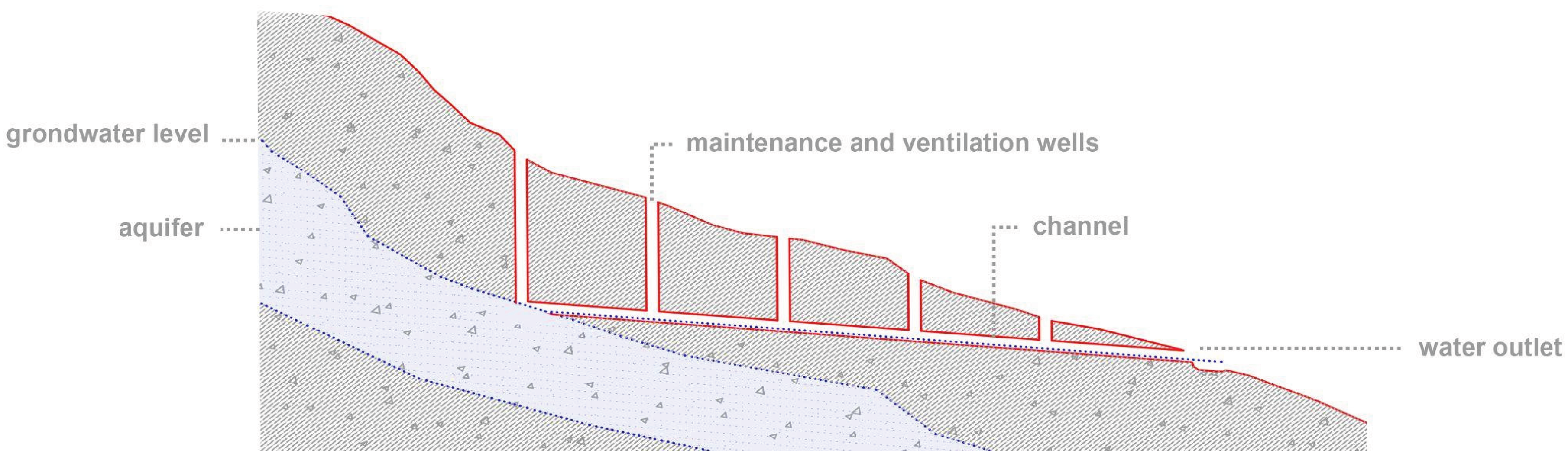
Figure 3.
Terraced urban development of the Old City of Mardin.
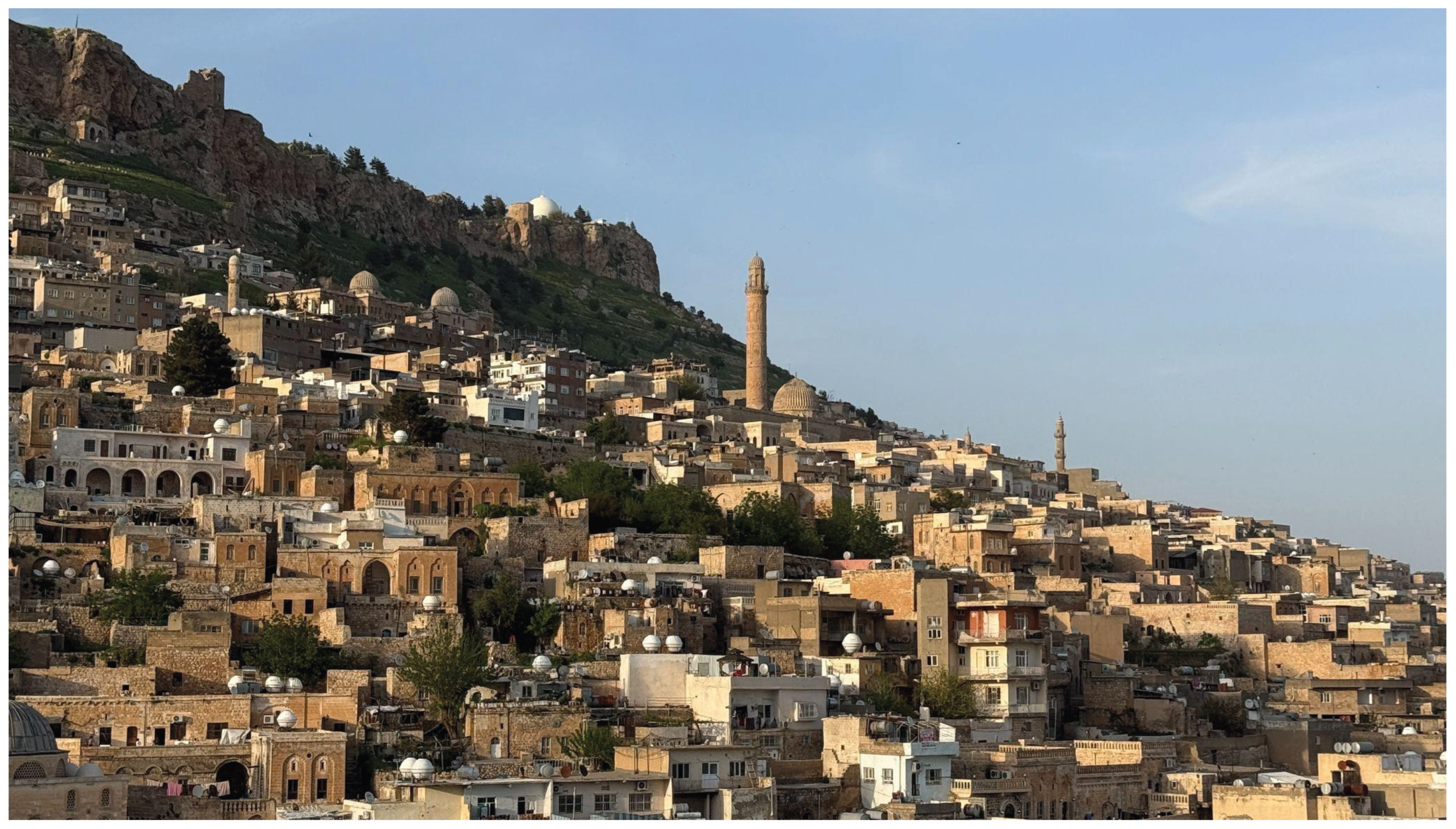
Figure 4.
QGIS Map showing the location of above-ground water-related structures documented in this study.
Figure 4.
QGIS Map showing the location of above-ground water-related structures documented in this study.
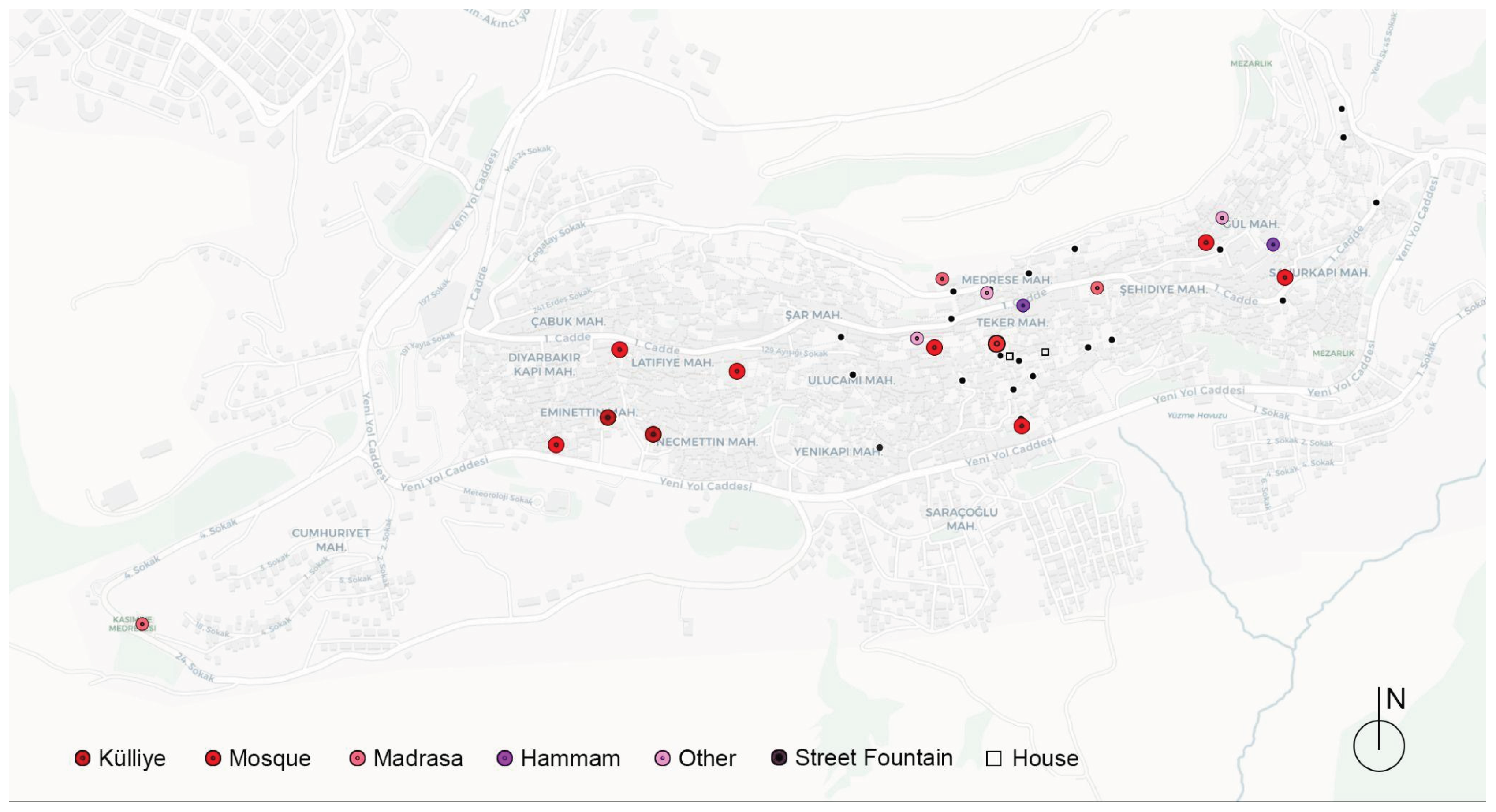
Figure 5.
QGIS Map showing the clusters of above-ground water-related structures documented in this study.
Figure 5.
QGIS Map showing the clusters of above-ground water-related structures documented in this study.
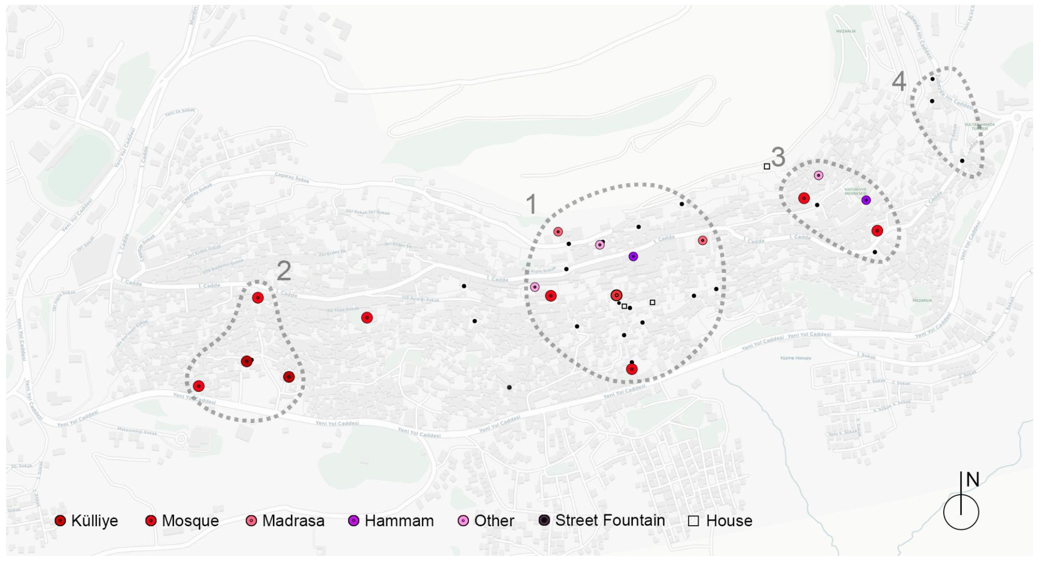
Figure 6.
Melha Fountain: a freestanding square fountain located at the junction of three alleys.

Figure 7.
Cevheriye Fountain in its urban setting.
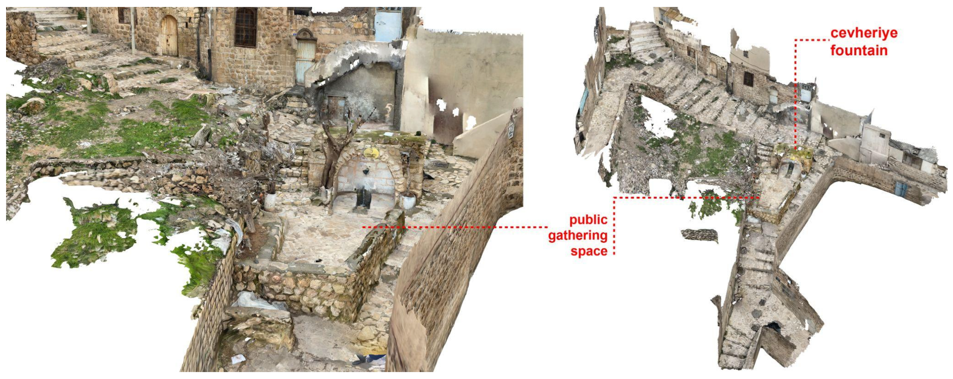
Figure 8.
Milliye Fountain embedded in the urban texture.
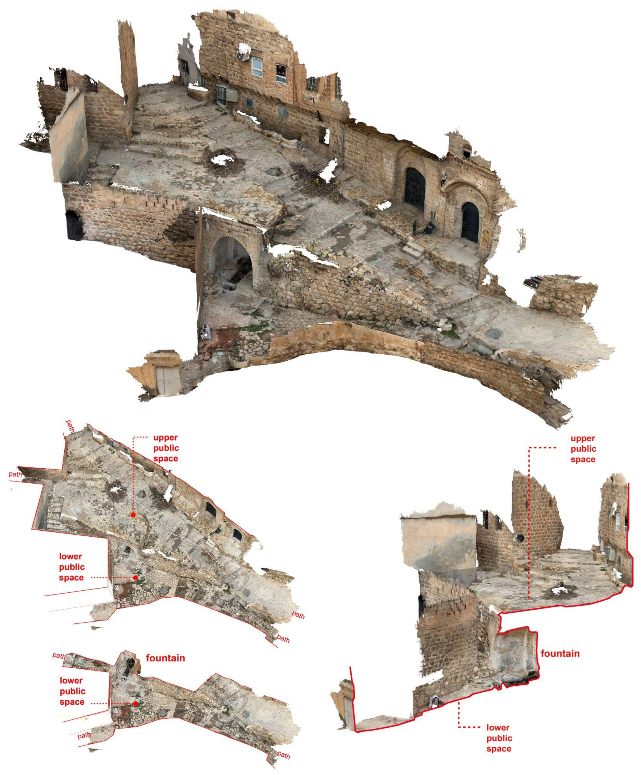
Figure 9.
Ayn Yahud (left) and Ayn Tumbaga (right) Fountains: exterior and interior views.
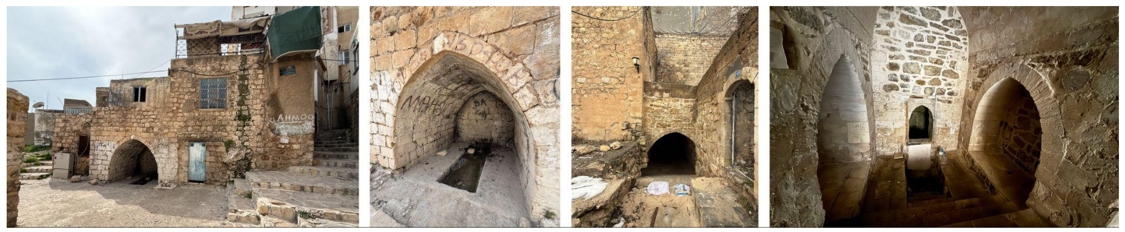
Figure 10.
Wells along the underground water channels leading to Sehidiye Madrasa (right) and Kayseriye Passage (left).
Figure 10.
Wells along the underground water channels leading to Sehidiye Madrasa (right) and Kayseriye Passage (left).
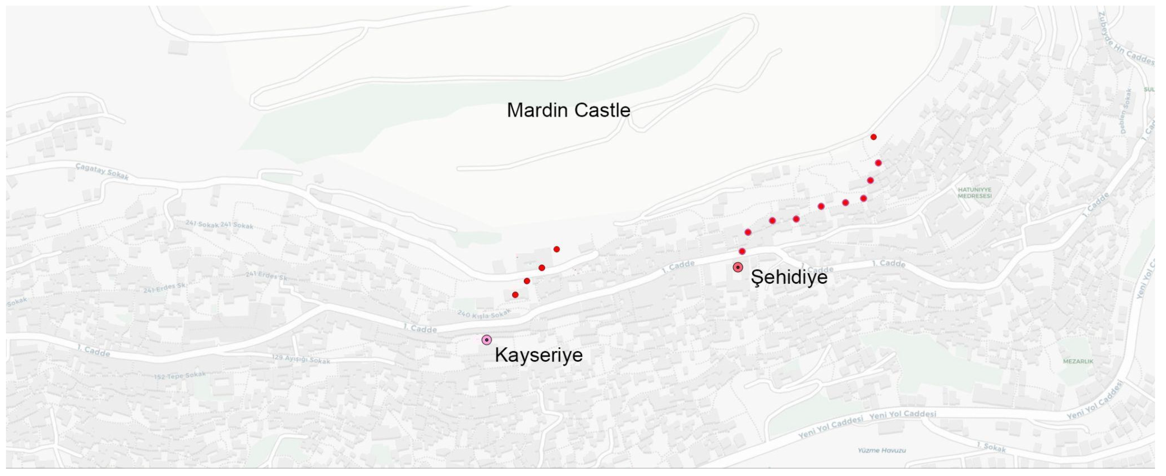
Figure 11.
Channel morphology: Channel plans and sections from Zinciriye, Kasimiye, Sehidiye Madrasas (left to right).
Figure 11.
Channel morphology: Channel plans and sections from Zinciriye, Kasimiye, Sehidiye Madrasas (left to right).
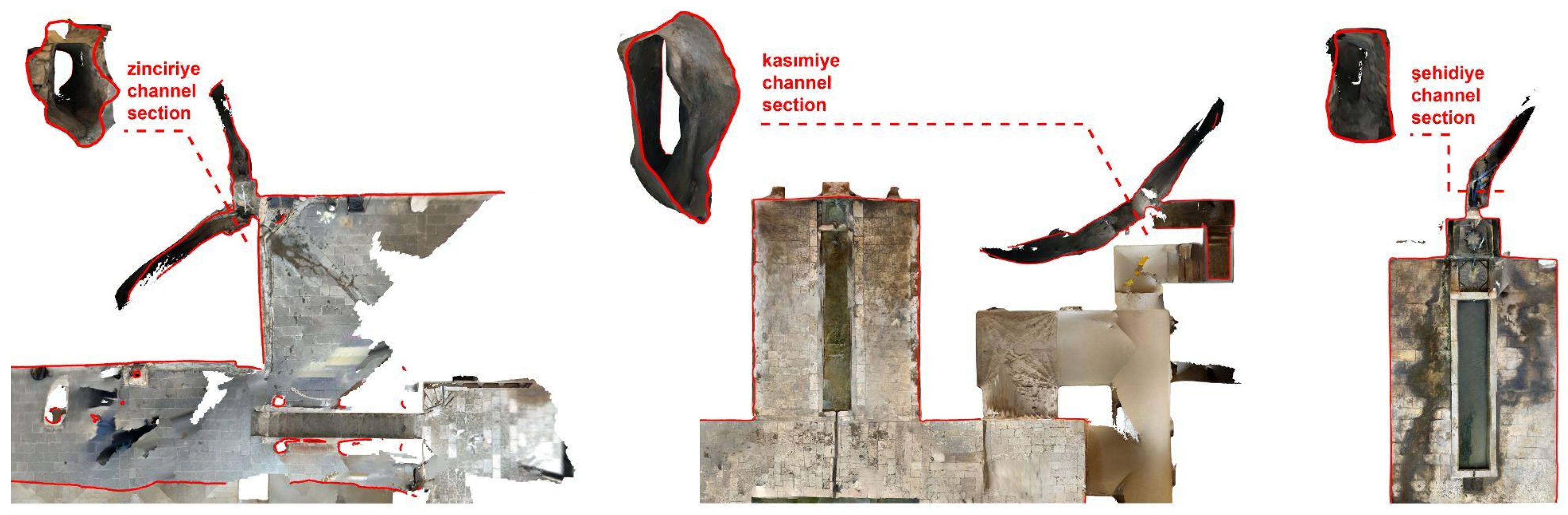
Figure 12.
Zinciriye Madrasa sectional illustrations showing route of the water.
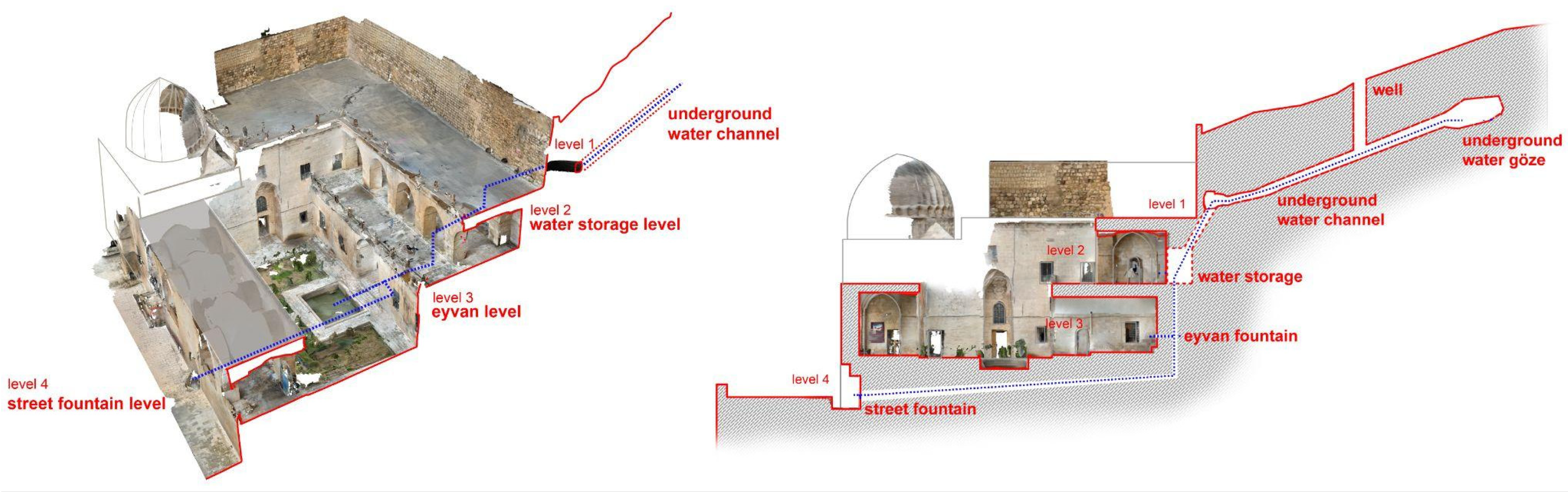
Figure 13.
A section showing the relation between Old Post Office and Sehidiye Madrasa, together with a representational demonstration of the underground water channel passing through House B and leading to Sehidiye, with the maintenance well.
Figure 13.
A section showing the relation between Old Post Office and Sehidiye Madrasa, together with a representational demonstration of the underground water channel passing through House B and leading to Sehidiye, with the maintenance well.
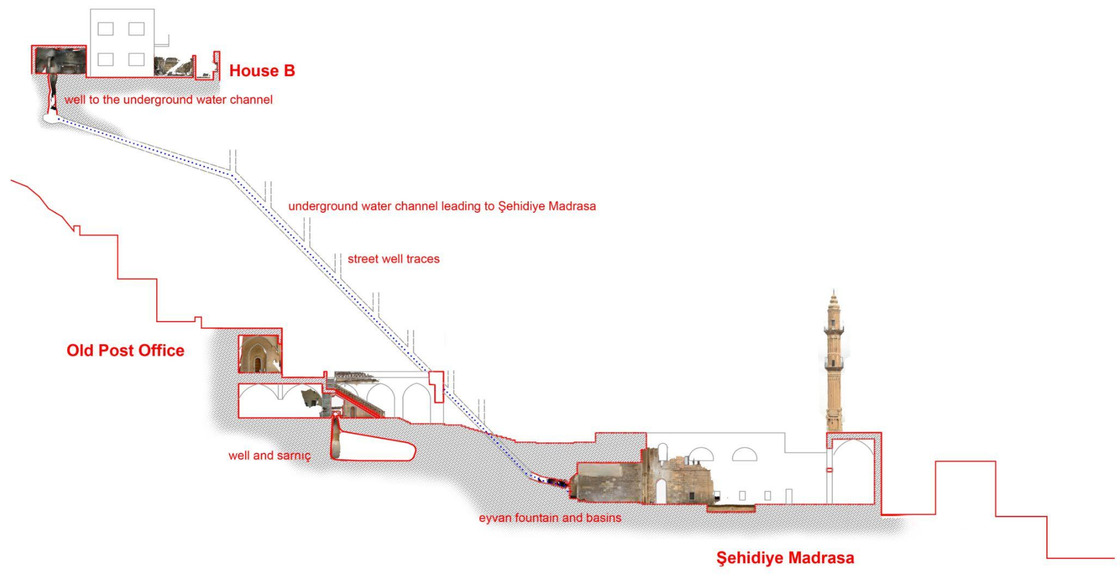
Figure 14.
Sehidiye Madrasa perspective and plan illustrations.
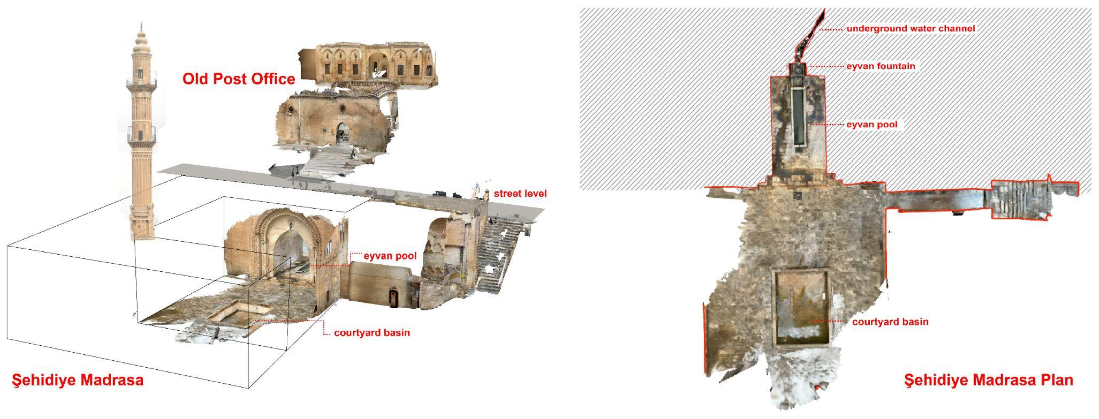
Figure 15.
Kasimiye Madrasa eyvan-courtyard/fountain-pool-basin sequence.
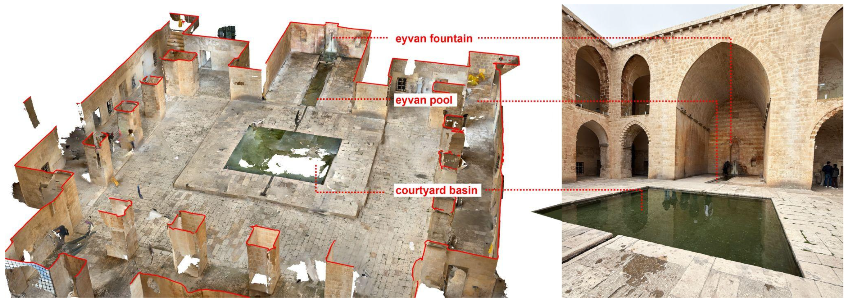
Figure 16.
Perspective and sectional illustrations of the Old Surur Garage showing the relationship between the shortest underground water channel and the building.
Figure 16.
Perspective and sectional illustrations of the Old Surur Garage showing the relationship between the shortest underground water channel and the building.
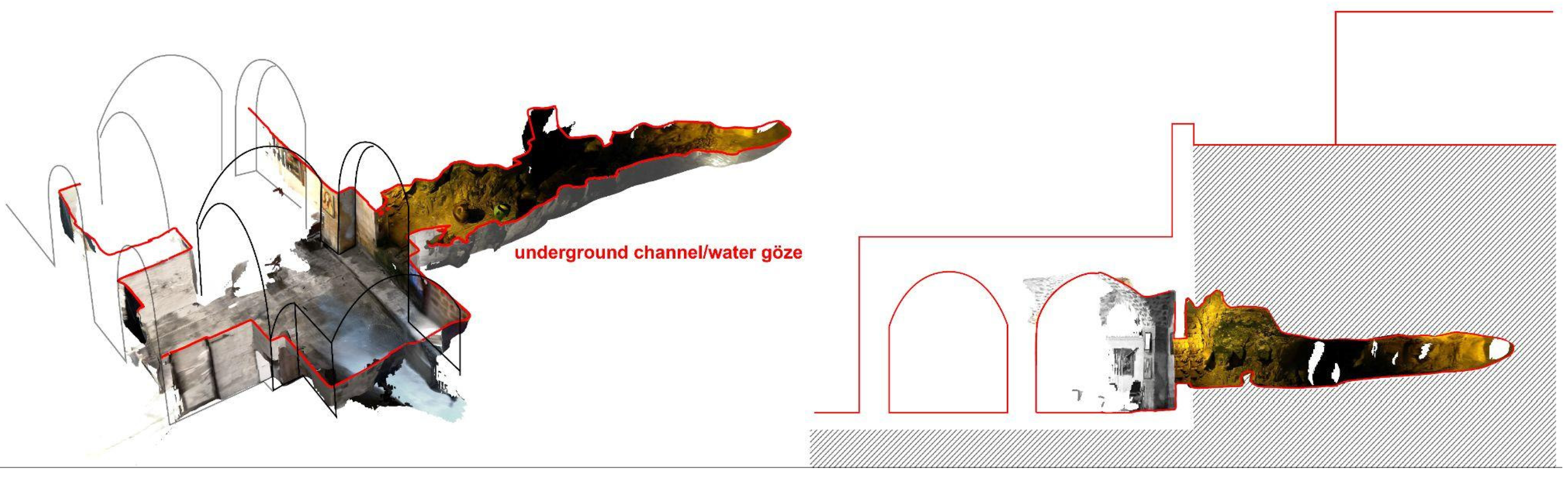
Figure 17.
Perspective plan and section illustrations of House A.
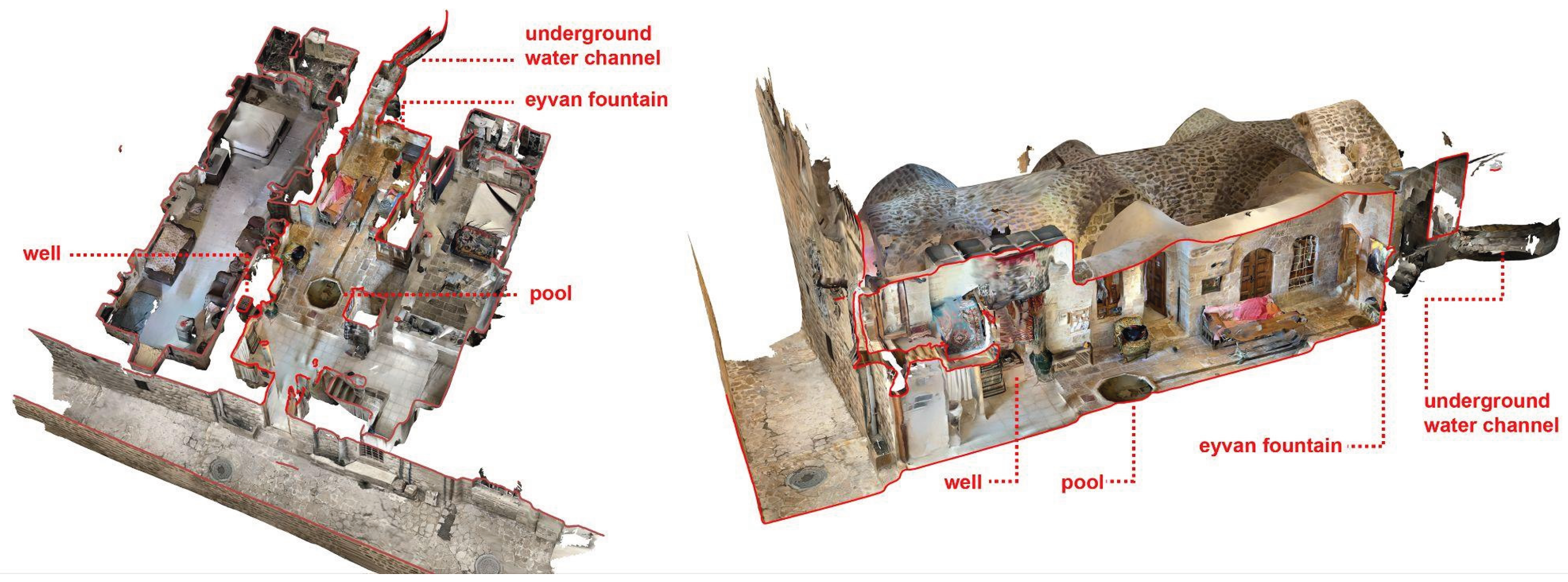
Figure 18.
Rooftop PVC water tanks altering the silhouette of the old city.
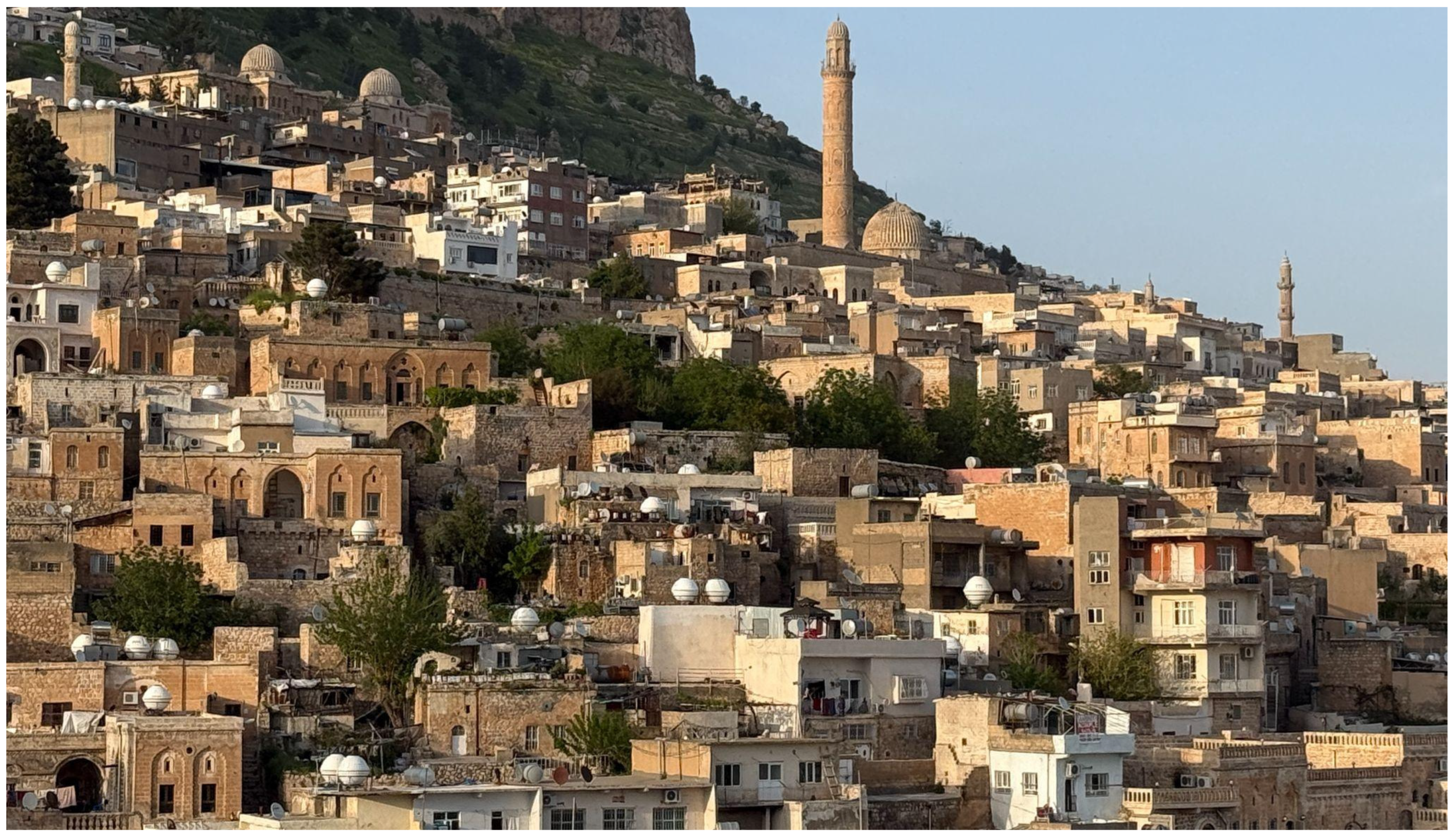
Figure 19.
Relationship between water infrastructure and the built environment.
Disclaimer/Publisher’s Note: The statements, opinions and data contained in all publications are solely those of the individual author(s) and contributor(s) and not of MDPI and/or the editor(s). MDPI and/or the editor(s) disclaim responsibility for any injury to people or property resulting from any ideas, methods, instructions or products referred to in the content. |
© 2026 by the authors. Licensee MDPI, Basel, Switzerland. This article is an open access article distributed under the terms and conditions of the Creative Commons Attribution (CC BY) license (http://creativecommons.org/licenses/by/4.0/).
Copyright: This open access article is published under a Creative Commons CC BY 4.0 license, which permit the free download, distribution, and reuse, provided that the author and preprint are cited in any reuse.