

Submitted:
10 June 2026
Posted:
11 June 2026
You are already at the latest version
Abstract
The coastal dunes of the Colombian Caribbean show highly variable vegetation dy-namics between 2015 and 2025. The study was conducted on five different beaches: Lipe, Salguero, Costa Verde, Gairaca, and Mendihuaca. Satellite images and the estimation of the SAVI index were used to evaluate changes in vegetation cover. The results show that Gairaca and Mendihuaca are ecosystems with the greatest ecological stability, due to their high vegetation values, lower presence of mobile sand, better moisture retention, and lower thermal stress. On the other hand, Lipe, Salguero, and Costa Verde show more fragmented cover, dominated by sparse vegetation and bare soils, which demonstrate greater geomorphological and ecological vulnerability. The period between 2015 and 2020 shows a general decrease in vegetation vigor, possibly related to water stress and adverse climatic conditions. After 2020, there were signs of recovery, although not with the same intensity at all sites. Salguero showed vegetation recolonization but still did not present structural consolidation. Lipe was the most unstable system, with greater deg-radation and low recovery capacity. This study confirms that vegetation cover is a key indicator of resilience, stability, and ecological succession in coastal dunes.
Keywords:
coastal dunes
; vegetation cover
; ecological resilience
; SAVI index
1. Introduction
Coastal dunes are primary habitats where steep gradients in salinity exposure, nutrient scarcity, sand burial, wind, and water limitation structure distinctive wild plant communities and associated fauna, while simultaneously providing ecosystem services such as coastal protection and cultural/recreational value. These systems are widely recognized as biodiversity-relevant habitats and as natural buffers against erosion and storm impacts, but they are also sensitive to environmental threats and human pressures that can alter vegetation cover and habitat quality over short timescales (Arévalo-Valenzuela et al., 2021; Lansu et al., 2025; Massarelli et al., 2023; Rivera et al., 2025).
Vegetation cover is a core attribute of dune habitat integrity because it modulates sand stabilization, surface roughness, microclimate, and the persistence of successional mosaics. Disturbance and stress can reduce plant cover, fragment patches, or shift dominance, with cascading consequences for dune functioning and the capacity of dunes to deliver protective and regulating services. In this sense, quantifying where and how vegetation cover changes provide an operational entry point to discuss habitat degradation and potential renaturation trajectories (Cini et al., 2025; Del Vecchio et al., 2022).
Climatic stressors—particularly drought and heat—are expected to be major drivers of vegetation condition and cover dynamics in dune landscapes. Hydro-climatic variability can influence greenness, productivity, and spatial patterns of vegetation in dunes, and several studies have explicitly examined links between meteorological variables and NDVI behavior in dune systems. At broader scales, the coupled behavior of vegetation indices and surface temperature has also been used to interpret moisture stress, because land-surface temperature (LST) often responds strongly to evaporative constraints and vegetation cover, making it a useful complementary proxy to drought-related stress when interpreted carefully (Karnieli et al., 2010; Li et al., 2023; Taminskas et al., 2020).
Remote sensing provides a reproducible approach to track dune vegetation over time, particularly where field access is limited and where change is spatially heterogeneous. Earth observation is widely used for coastal habitat mapping and monitoring, and recent syntheses emphasize its value for capturing habitat extent and dynamics, including in dune environments. However, dunes pose specific challenges because vegetation is frequently sparse and discontinuous, and the bright sand background can bias spectral signals and complicate change detection if methods are not tuned to low-cover conditions. These constraints motivate careful selection of spectral metrics, robust masking (e.g., water/clouds), and explicit uncertainty reporting (Ettritch et al., 2018; Martín-Gallego et al., 2026).
Vegetation indices derived from red and near-infrared reflectance, such as the Normalized Difference Vegetation Index (NDVI), remain the most common starting point for monitoring vegetation dynamics and change from multispectral imagery. NDVI’s formulation and interpretation are well established, and it is routinely used to estimate relative greenness and to support habitat mapping. Nonetheless, in sparsely vegetated or bright-soil contexts, NDVI may be sensitive to soil background and mixed pixels; therefore, soil-adjusted indices (e.g., SAVI-type approaches) or complementary features can improve robustness when the substrate exerts strong influence on reflectance (Chen et al., 2025; Dawelbait & Morari, 2008).
Within this context, this manuscript targets coastal dune habitats in five beaches of the Colombian Caribbean (Lipe, Salguero, Costa Verde, Gairaca and Mendihuaca) and quantifies vegetation cover change between 2015 and 2025 using 10 m multispectral imagery. The analytical focus is twofold: (i) to produce comparable dune-cover maps and change statistics over the study period, and (ii) to evaluate whether spatial patterns of cover change are associated with drought and temperature-related stress signals, operationalized through remotely sensed proxies.
Finally, a dune-focused, moderate-to-high resolution (10 m) assessment is particularly relevant because it bridges site-scale ecological interpretation with landscape-scale comparability. While very-high-resolution drone products can map fine patch structure, 10 m satellite imagery enables consistent, repeatable monitoring across multiple sites and years, supporting cross-site contrasts that are useful for identifying where dune habitats appear most vulnerable—or most resilient—to climatic stress. This type of evidence can inform priorities for coastal habitat conservation and management without assuming that all observed changes are exclusively climate-driven, a key nuance when interpreting nature–human coupled systems in touristic and peri-urban coasts (Ettritch et al., 2018; Muir et al., 2025; Rivera et al., 2025).
2. Materials and Methods
2.1. Study Site and Ecological Context
The study area for this research comprised the dunes located on five beaches of the Colombian Caribbean: Lipe, Salguero, Costa Verde, Gairaca and Mendihuaca, all located in the department of Magdalena. The area borders the Caribbean Sea along 255 km of coastline, extending from Bocas de Ceniza to the mouth of the Palomino River. It includes 1,258 km2 of marine and coastal ecosystems and 297,210 ha within the National System of Protected Areas, including Tayrona National Natural Park, the Salamanca Island Road Park, and the Ciénaga Grande de Santa Marta Fauna and Flora Sanctuary. This area is characterized by desert and semi-desert climates and presents four climatic periods: major dry season (December–April), minor rainy season (May–June), minor dry season (July–August), and major rainy season (September–November) (Mancera Pineda et al., 2013).
This research is contextualized within the longitudinal assessment of five critical coastal dune ecosystems distributed along the Colombian Caribbean coastline near Santa Marta (Figure 1): Mendihuaca (Figure 1e), Lipe (Figure 1c), Salguero (Figure 1b), Gairaca (Figure 1d), and Costa Verde (Figure 1a). As illustrated by their contrasting spatial contexts, these systems represent a biogeographical gradient of environmental heterogeneity and anthropogenic pressure that heavily shapes the structure and composition of their supralittoral psammophilous communities. For instance, Gairaca, embedded within the protected boundaries of the Tayrona National Natural Park, functions as a reference ecosystem with relatively unaltered primary succession dynamics, characterized by pocket dunes stabilized by a matrix of pioneer vegetation and xerophytic scrub (Ojeda-Manjarrés et al., 2026). In stark contrast, systems such as Costa Verde and Salguero are visibly subjected to chronic stress derived from adjacent coastal urbanization and infrastructure, leading to excessive trampling and habitat fragmentation that interrupts the natural aeolian sediment flux and alters the recruitment of dune-forming plant species (Martínez & Psuty, 2004; Ojeda-Manjarrés et al., 2026). The regional climate, bimodal in nature and heavily influenced by the migration of the Intertropical Convergence Zone (ITCZ) and the variability of the El Niño-Southern Oscillation (ENSO), imposes severe regimes of water deficit and high solar radiation. Within this context of extreme environmental stress, the colonization, survival, and expansion of vascular plant cover become the primary ecosystem engineers, facilitating sediment accretion, reducing surface albedo, and creating crucial microhabitats for coastal biodiversity (Maun, 2009; Pye, 1983). Therefore, quantifying the spatiotemporal dynamics of these plant communities is not merely a geomorphological exercise, but a direct assessment of the resilience and ecological viability of the land-sea ecotone in the face of global environmental change.
2.2. Cloud Computing Framework and Environmental Masking Protocols
To capture the phenological complexity and successional trajectories of coastal vegetation over a decade (June 2015 to December 2025), a massive analytical processing framework was implemented using the Google Earth Engine platform (Gorelick et al., 2017). Monitoring highly dynamic ecosystems requires a spatial and temporal resolution capable of detecting subtle changes in biomass before catastrophic state transitions occur. To this end, the Level-1C Harmonized collections of Sentinel-2 (MSI) and Collection 2 Level-2 of Landsat-8 (OLI/TIRS) were integrated. Sentinel-2 provides a 10-meter spatial resolution in the visible and near-infrared (NIR) bands, which is fundamental for discerning canopy structure in fragmented plant communities, while Landsat-8 enables the characterization of surface thermal stress through its Thermal Infrared Sensor (TIRS). The initial processing required the rigorous application of masking algorithms to isolate the fundamental ecological niche of terrestrial flora. Using bitwise logical operations on the QA60 (Sentinel-2) and QA_PIXEL (Landsat-8) bands, atmospheric interference caused by opaque clouds and cirrus was eliminated, ensuring that the measured reflectance truly corresponded to the biophysical properties of the foliar tissue and the substrate (Singh et al., 2025). Furthermore, given that the intertidal interface fluctuates constantly and wet sand or algal biocrusts can generate false positives in biomass detection, dynamic water masking was implemented. The Modified Normalized Difference Water Index was calculated, formulated as:
MNDWI=(Green-SWIR)/(Green+SWIR)
The systematic exclusion of pixels with MNDWI values greater than zero ensured that the analysis was strictly restricted to the supralittoral zone, avoiding biases introduced by tides, coastal squeeze, and episodic flooding, thereby precisely delineating the available habitat area for plant colonization (Xu, 2006).
2.3. Ecophysiological Proxies: Vegetation, Moisture, and Thermal Stress
The quantification of ecosystem health was based on the extraction of three biophysical variables, conceptualized as proxies for photosynthetic activity, hydric status, and substrate microclimate. First, the traditional use of the NDVI was discarded due to its well-known sensitivity to background reflectivity; in dune ecosystems, the high reflectance (albedo) of quartz or bioclastic sands dominates the pixel signal, severely underestimating the foliar density of sparse plant communities. Instead, the Soil Adjusted Vegetation Index (SAVI), developed by Huete (Huete, 1988), was implemented, incorporating a canopy correction factor L=0.5 empirically calibrated to mitigate the spectral noise of the background substrate:
SAVI=(NIR-Red) /(NIR+Red+L) (1+L)
Biologically, SAVI acts as a direct indicator of the fraction of absorbed photosynthetically active radiation (fAPAR) and above-ground biomass (Valenzuela-Jara et al., 2025; Yousefi Lalimi et al., 2017), allowing for the early detection of the establishment of stolons and rhizomes of pioneer species (Gallego-Fernández & Martínez, 2011; Gayosso-Soto et al., 2024). To evaluate the water balance of these communities, the Normalized Difference Moisture Index (NDMI) was calculated using the shortwave infrared (SWIR) band. The NDMI responds to energy absorption by water molecules in the spongy mesophyll tissue and the superficial soil horizons, serving as a measure of water stress and cellular turgor (Ali et al., 2019). Concurrently, Land Surface Temperature (LST) was derived from the Landsat-8 B10 thermal band by transforming spectral radiance into degrees Celsius (Avdan & Jovanovska, 2016). LST is a critical ecophysiological parameter in dunes, as extreme surface temperatures (often exceeding 45 °C on bare soils) act as a lethal abiotic barrier that inhibits seed germination, denatures cellular proteins, and accelerates seedling senescence, ultimately dictating the spatial limits of ecological succession (Maun, 2009).
2.4. Successional Seral Stages and Spatiotemporal Dynamics
To translate continuous spectral signals into ecologically meaningful units, a hierarchical structural classification model based on Soil Adjusted Vegetation Index (SAVI) thresholds was developed. This model divides the dune ecosystem into four distinct seral stages or density states, reflecting the successional gradient from highly dynamic mobile sands to structurally consolidated coastal scrublands (Table 1) (Hesp, 2002; Tsoar, 2005).
Building upon this categorical framework, a spatiotemporal transition matrix is constructed by generating annual median composites for the baseline (2015) and end-line (2025) periods to document the spatial dynamics of change. Transitional pixels are reclassified into explicit metrics of disturbance and resilience. Specifically, the “Loss” of biomass (successional regression) indicates the reactivation of erosive foci or anthropogenic degradation, while “Gain” (successional progression) reflects the ecosystem’s capacity to self-organize and expand its biological frontier. These transitional metrics are meticulously quantified in both absolute areas (square meters) and relative percentages. This dual quantification allows for the precise identification of critical threshold-crossing processes, such as “Severe Degradation” (defined as the direct, abrupt loss of climax vegetation to mobile sand), which warns of a potential morphodynamic collapse of the dune system, and “Total Recovery,” which exemplifies the success of natural regeneration following historical disturbances.
2.5. Eco-Climatic Feedbacks and Statistical Assessment of Ecosystem Resilience
The long-term stability of the dune ecosystem is not a static phenomenon, but a dynamic equilibrium mediated by climate and geomorphology. To evaluate these underlying trends, a non-parametric Theil-Sen regression analysis was implemented over the continuous SAVI time series between 2015 and 2025. This statistical method estimated the temporal magnitude of greening trajectories (increased vigor) or browning trajectories (chronic senescence or mortality), being statistically robust against phenological outliers or sporadic sensor anomalies (Sen, 1968). Simultaneously, the interannual standard deviation of SAVI was calculated as an empirical indicator of geomorphological and biological instability; zones with high variance denote areas subjected to dynamics of sand burial and constant deflation, where plants continuously struggle to remain in the photic zone (Maun, 2009). Finally, to demonstrate the coupled feedback loop between biological cover and physical microclimate, a spatial extraction of statistics (grouped reduce region) was performed, linking the temporal dynamic classes (Loss vs. Stability) with the median LST and NDMI maps. This comprehensive ecophysiological analysis tested the hypothesis that the loss of the vegetative boundary layer precipitates a drastic increase in land surface temperature (thermal anomaly) and a collapse in substrate moisture retention (NDMI deficit). This positive environmental feedback loop generates hostile microclimatic conditions that prevent secondary recruitment, perpetuating a state of mobile sand and ecosystem degradation that can only be reversed through ecological restoration interventions or exceptionally favorable climatic variations. The results of all spatial reductions, net spatial balances (m^2), and percentage rates of change were structured into relational tables and exported to cloud matrices to ensure the total reproducibility of this biogeographical monitoring framework.
3. Results
3.1. Spatial-Temporal Patterns of Vegetation Cover (SAVI) Across Dune Systems (2015–2025)
This analysis shows significant spatio-temporal heterogeneity in vegetation vigor among the sampling sites. SAVI values indicate differences in vegetation cover dynamics among the five monitored ecosystems during the 2015–2025 period (Figure 2). The time series shows that Gairaca consistently presented the highest SAVI values, ranging from 0.24 to 0.39, indicating well-established and persistent vegetation cover. Mendihuaca showed the second-highest vegetation index, with values ranging from 0.21 to 0.32. In contrast, Costa Verde, Lipe, and Salguero presented the lowest SAVI values, below 0.21, indicating sparse and fragmented vegetation patches associated with more unstable dune surfaces.
The period between 2015 and 2020 showed a generalized decrease in SAVI across the five sampling sites. Lipe decreased from a SAVI value of 0.20 in 2015 to 0.08 in 2020, representing the most pronounced vegetation decline among all sites. Salguero decreased from 0.17 to 0.11 during the same period. This indicates a regional-scale suppression of vegetation vigor, possibly associated with prolonged water stress and greater substrate exposure.
After 2020, the sampling sites showed progressive recovery, although this response varied considerably among sites. Gairaca and Mendihuaca showed the fastest recoveries in SAVI values, reaching 0.34 and 0.25, respectively, by 2025, while Costa Verde, Lipe, and Salguero remained within low to intermediate vegetation density ranges. Gairaca showed the greatest recovery, increasing from a temporary minimum of 0.24 in 2020 to values close to its initial 2015 condition by the end of the study period.
The interannual fluctuations in SAVI were closely associated with the ENSO climatic phases, highlighting the strong sensitivity of dune vegetation to regional hydroclimatic variability. During the strong El Niño event of 2015–2016, most study areas exhibited marked reductions in SAVI, particularly Lipe and Mendihuaca, suggesting increased water stress, higher substrate exposure, and reduced vegetation vigor under drier and warmer conditions. In contrast, the subsequent La Niña phases (2017–2018 and 2020–2022) were generally associated with stabilization or recovery of vegetation cover, especially in Gairaca and Mendihuaca, likely due to enhanced moisture availability and reduced thermal stress. However, the response was spatially heterogeneous, as some systems such as Lipe and Salguero continued to exhibit low SAVI values despite wetter climatic conditions, indicating that local geomorphological instability and chronic disturbance may constrain vegetation recovery beyond climatic forcing alone. Notably, the El Niño phase of 2023–2024 did not trigger generalized SAVI collapse, particularly in Gairaca, which maintained increasing vegetation vigor, suggesting greater structural resilience and microclimatic buffering capacity in more consolidated dune systems.
3.2. Redistribution of SAVI-Derived Successional Seral Stages
The hierarchical classification based on the SAVI index revealed significant differences in the successional structure of the studied dune systems, as well as notable changes in the proportions of vegetation stages during the 2015–2025 period (Figure 3). Gairaca and Mendihuaca were characterized by high proportions of dense vegetation and limited bare soil exposure, confirming their advanced successional maturity and stabilization.
Costa Verde, Lipe, and Salguero presented early successional stages. Costa Verde showed an increase in bare soil, with only a slight increase in vegetation cover. In Lipe, the landscape was dominated by sparse vegetation and bare sand throughout the study period, whereas Salguero showed clear recovery in vegetation cover. However, bare soil remained the dominant land-cover class during the monitoring period. This change suggests active horizontal colonization by early psammophilous species, although without a transition yet toward moderate or dense structural states.
The redistribution data of the successional stages calculated from the SAVI index indicate that positive trends in this index do not necessarily imply complete ecological succession. In several sampling sites, the observed vegetation gains were related to transitions from bare substrate to sparse pioneer cover, whereas Gairaca and Mendihuaca maintained significant proportions of intermediate to dense successional vegetation.
3.3. Interannual Trajectories and Resilience Patterns of Vegetation Vigor
Median SAVI trajectories revealed strong spatial contrasts in long-term vegetation performance among the five coastal dune systems (Figure 4; Table 2). Gairaca maintained the highest vegetation vigor throughout the monitoring period, with SAVI values consistently ranging between 0.24 and 0.39, followed by Mendihuaca, whose values remained within an intermediate range of 0.21–0.32. In contrast, Costa Verde, Lipe, and Salguero persisted under lower vegetation density states, rarely exceeding SAVI values of 0.20.
A common declining trend was observed between 2015 and 2020 across all sites, indicating a regionally synchronized contraction of plant cover. The steepest temporary reductions were recorded in Lipe (−0.12) and Salguero (−0.06), whereas Gairaca and Mendihuaca showed comparatively moderate decreases despite remaining within higher absolute vegetation levels. This generalized decline suggests that coastal dune vegetation across the region experienced a phase of reduced vigor and increased substrate exposure during the first half of the monitoring decade.
Despite this contraction, all study areas exhibited some degree of post-2020 recovery. Gairaca showed a marked positive rebound of +0.10 SAVI units, recovering much of its former canopy condition, while Lipe exhibited the highest relative increase (+0.12), although from a critically low baseline. Costa Verde and Salguero displayed intermediate recoveries (+0.07), whereas Mendihuaca showed only slight improvement (+0.02). These differences indicate substantial variation in the resilience capacity of each dune system.
Interannual fluctuation amplitudes further emphasize contrasting ecosystem stability. Lipe (0.14) and Salguero (0.13) showed pronounced oscillatory behavior associated with highly disturbance-sensitive vegetation mosaics, while Gairaca, despite a comparable amplitude (0.15), maintained these fluctuations within a consistently high-cover state. This suggests that variability in Gairaca reflects adaptive climatic responsiveness rather than structural collapse.
When comparing the initial and final years of the time series, net SAVI balances revealed slight long-term declines in Gairaca (−0.05), Mendihuaca (−0.05), and Costa Verde (−0.03), no net change in Lipe, and only a marginal gain in Salguero (+0.01). Consequently, the decade was characterized not by a uniform process of vegetation expansion, but by an initial regional deterioration followed by incomplete and site-dependent recovery.
The ecological patterns revealed distinct trajectories of vegetation stability and resilience among the studied dune systems. Mendihuaca exhibited an intermediate vegetation cover with the highest temporal stability, suggesting a relatively balanced successional state. In contrast, Gairaca maintained a persistently high vegetation cover associated with strong climatic buffering capacity and greater ecosystem resilience. Lipe displayed the highest temporal variability, indicating a structurally unstable vegetation highly sensitive to environmental disturbance. Salguero was characterized by a fragmented vegetation cover with moderate climatic sensitivity, whereas Costa Verde represented a low-cover system with moderate structural instability and limited ecological consolidation.
3.4. Spatial Gain–Loss Transitions and Net Successional Balance
This spatial transition revealed substantial heterogeneity in vegetation reorganization among the sampled sites (Figure 4). Salguero showed the largest successional transition, with approximately 51 × 103 m2 of vegetation gain, exceeding the loss area of 40 × 103 m2. This generated the only positive net spatial balance among all sampling sites, indicating a strong process of vegetation recolonization and horizontal expansion of the established plant cover. Lipe showed unfavorable ecological responses, with a vegetation gain of 9 × 10³ m2 and a loss of 16 × 103 m2. Costa Verde presented nearly equivalent gains and losses, indicating a low-cover dune system in an almost stationary but fragile equilibrium.
The Gairaca and Mendihuaca sites showed small absolute transition areas. In Gairaca, vegetation gain was very small in relation to the detected loss surface, while Mendihuaca showed only minor differences between both dynamics. These spatial changes are consistent with more consolidated vegetation matrices, where large-scale horizontal expansion is restricted by the preexistence of stable vegetation cover and by lower proportions of bare soil available for colonization.
The study of the SAVI-derived gain–loss balance among sites shows that temporal trajectories may conceal the different spatial behaviors present across the sampling sites. While some dune systems maintain spectral stability through persistent vegetation patches, others show an internal redistribution of successional stages, reflecting different pathways of ecological resilience, saturation, or degradation.
The integrated resilience assessment revealed contrasting ecological trajectories among the studied dune systems (Table 3). Mendihuaca was characterized by a temporally stable ecosystem with only minor successional regression, representing an intermediate dune matrix with high structural stability but limited spatial expansion. Gairaca exhibited a structurally consolidated and spatially saturated system, corresponding to mature dune vegetation with persistently high cover and a reduced colonization frontier. In contrast, Lipe showed highly dynamic but degradation-prone behavior, with strong interannual oscillations and an overall trend toward net successional retreat. Salguero demonstrated an expanding yet weakly consolidated recovery pattern, characterized by broad spatial recolonization primarily driven by early-successional vegetation. Finally, Costa Verde represented a low-cover and structurally unstable system, where sparse vegetation persists under chronic environmental constraints and limited ecological consolidation.
3.5. Integrated Eco-Geomorphological Indicators of Dune Resilience
The integrated eco-geomorphological resilience indicators show differences among the studied sites (Table 4). Gairaca and Mendihuaca were the sites with the most favorable ecological conditions, characterized by lower proportions of mobile sand, greater substrate moisture retention, and reduced thermal stress in stable vegetated zones. Gairaca presented the lowest percentage of mobile substrate (11.95%) and the highest proportion of dense vegetation (3.08%), confirming its advanced successional consolidation. Mendihuaca recorded the lowest land surface temperature among all sites (30.95 °C) and the highest NDMI value (0.33), indicating the greatest microclimatic buffering capacity and water retention among the studied sites.
In contrast, Costa Verde, Lipe, and Salguero were characterized by abundant mobile sand (>39%) and limited vegetation cover. Lipe showed the highest degradation of vegetated surface area (900 m2) among all sampled sites, making it the area with the most critical ecological scenario. It also presented high geomorphological instability (0.089) and the warmest microclimate under stable vegetation (38.40 °C). NDMI values in loss zones remained negative, indicating severe moisture depletion and a possible feedback loop that inhibits long-term plant establishment.
Costa Verde remained with 64.72% of its surface classified as mobile sand and showed negative NDMI values in degraded sectors. Although both Costa Verde and Lipe exhibited positive annual SAVI trends, the limited presence of dense vegetation indicates that these gains are related to sparse pioneer colonization rather than true structural recovery of the ecosystem. Salguero, despite maintaining high proportions of mobile substrate (61.37%) and an absence of dense vegetation, showed no severe degradation events and exhibited a positive annual trend in the SAVI index. This indicates that the current vegetation dynamics at this site are dominated by horizontal recolonization of bare sand rather than by the collapse of established vegetation patches.
The thermal, hydric, geomorphological, and structural indicators show that the studied sites form a clear resilience gradient. Gairaca and Mendihuaca function as the most buffered and established ecosystems; Salguero represents an early regenerative stage; and Costaverde, especially Lipe, remain under conditions of chronic instability and low successional maturity.
3.6. Multivariable Classification of Eco-Geomorphological Resilience
Through the multivariate radar analysis, seven normalized resilience indicators were synthesized into an integrated comparative framework, revealing clear functional differentiation among the studied dune ecosystem sites (Figure 5). Gairaca showed the broadest and most balanced resilience profile, with consistently favorable values for dense vegetation, mobile sand stabilization, and moisture retention. This indicates that Gairaca is the dune system with the greatest ecological structuring. Mendihuaca also showed high resilience values, with strong performance in moisture retention, low thermal stress, and geomorphological stability. Although its dense vegetation component was lower than that of Gairaca, the relatively uniform distribution of its radar profile indicates a persistent vegetation matrix, lower oscillatory stress, and favorable substrate conditions for long-term maintenance.
Costa Verde and Salguero showed contracted resilience polygons, indicating limited structural development despite moderate performance in some selected variables. These systems were characterized by favorable values in annual SAVI trends and low severe degradation, but also by limited moisture retention, absence of dense vegetation, and a high proportion of mobile substrate. Salguero combines low degradation with moderate signs of annual greening; however, it presents weak hydric and structural characteristics, which are necessary for complete successional stabilization. Lipe, according to the radar analysis, showed the lowest and narrowest scores across most resilience dimensions. Although it exhibited a positive SAVI trend, it also showed low moisture availability, high geomorphological instability, and a complete absence of dense vegetation.
The radar chart (Figure 5) indicates that dune resilience is governed by the interaction of the studied eco-geomorphological variables, rather than by a single vegetation metric. Therefore, the five studied sites establish a clear functional gradient, ranging from consolidated ecological buffering (Gairaca), through stable persistence (Mendihuaca), to disturbance-limited recovery (Salguero and Costa Verde), and finally to a condition of chronic instability (Lipe).
4. Discussion
The results show that the studied dune sites —Lipe, Salguero, Costa Verde, Gairaca, and Mendihuaca— in the Colombian can buffered spatial and temporal heterogeneity in the dynamics of their vegetation cover. This confirms the dynamic and sensitive nature of this type of coastal ecosystem in response to climate and geomorphological disturbances. The changes observed in the SAVI index values during the period 2015–2025 indicate strong differences in the levels of ecological stability, resilience, and successional consolidation among the sampled sites. There is a strong relation between the SAVI values and ENSO variability.
The fluctuations in SAVI index suggest that vegetation cover and physiological vigor may vary at sub-annual temporal scales in response to seasonal rainfall pulses and drought periods. In coastal dune ecosystems, these short-term oscillations are frequently associated with phenological responses such as leaf senescence, canopy thinning, and partial deciduousness, particularly under water-limited conditions. Consequently, temporary declines in SAVI do not necessarily indicate irreversible vegetation loss but may instead reflect adaptive eco-physiological strategies that reduce transpiration and metabolic costs during periods of hydric stress. The seasonal reductions in canopy density and foliar biomass significantly affect near-infrared reflectance and vegetation indices in drought-prone and coastal ecosystems. Moreover, the strong climatic seasonality characteristic of tropical coastal dunes promotes rapid vegetation responses to changes in soil moisture availability, resulting in pronounced short-term variability in vegetation spectral signals (D’Alessandro et al., 2022).
Beaches such as Gairaca and Mendihuaca showed the greatest structural and functional stability among all sites, followed by Costa Verde, Lipe, and Salguero, the latter being characterized by high ecological and geomorphological vulnerability. Similar patterns are described by Martínez et al. (2013), the vegetation cover in the ecosystems constitutes a key indicator of stability and resilience in the established ecological dynamics. The high values obtained in the SAVI index for the Gairaca and Mendihuaca sites show that the vegetation cover in these areas can buffer different environmental disturbances and pressures. Hernández-Hernández et al., (2023) demonstrated that dune vegetation plays a fundamental role in sediment stabilization, moisture retention, and the reduction of coastal erosion on beaches, operating as a natural barrier against different types of extreme climatic events. The dense vegetation present in these sites favors ecosystem stability. Similar results were reported by (Ojeda-Manjarrés et al., 2026), who found that Gairaca and Mendihuaca exhibited the highest vegetation cover among all sites studied along the northern Colombian Caribbean coast. This greater vegetation cover, reflected in high SAVI values, is supported by the presence of representative tree species associated with more conserved dune systems, such as Morisonia odoratissima, Senegalia tamarindifolia, Platymiscium pinnatum, Morisonia tenuisiliqua, and Erythroxylum hondense (Ciccarelli & Bona, 2022; Ojeda-Manjarrés et al., 2026). In Mendihuaca, vegetation cover is further enhanced by the contribution of agriculturally and ecologically important species such as Cocos nucifera, which coexists with pioneer and shrubby vegetation that plays a key role in substrate stabilization, including Coccoloba uvifera, Sphagneticola trilobata, and the creeping vine Canavalia rosea. The accumulation of sand, together with reduced sediment mobility and the maintenance of more humid microclimatic conditions characterized by a single dry season, likely promotes greater environmental stability at these sites (Strypsteen et al., 2024).
Otherwise, the low SAVI values recorded across the sites Lipe, Salguero and Costa Verde between 2015 and 2020 coincide with local patterns associated with extreme climatic events and prolonged periods of water stress linked to ENSO variability in the recorded ecosystems. The results also suggest that the ecosystem is strongly affected by hydroclimatic variability and substrate instability, which together constrain successional progression and vegetation persistence. The high percentages of mobile sand, negative NDMI values, and increased thermal stress observed at this site show that ecosystem degradation processes may be related to low water retention capacity and weak structural dynamics of the vegetation. These results coincide with research conducted by (Navarro et al., 2011), which indicates that dune systems with little vegetation cover are more susceptible to erosion processes, geomorphological degradation, and loss of resilience in their ecological dynamics.
Lipe exhibited the strongest decline in SAVI index cover throughout the study period, revealing a highly disturbance-sensitive dune system with limited ecological resilience and a marked reduction in vegetation vigor. According to (Ojeda-Manjarrés et al., 2026), the vegetation in Lipe is primarily composed of arboreal and shrub strata, reaching nearly 80% cover. Therefore, the observed decrease in SAVI values may be associated with the seasonal foliage loss of deciduous species such as Astronium graveolens, Pithecellobium dulce, Tecoma stans, Platymiscium pinnatum, and Pereskia guamacho. In addition, short-lived herbaceous species with life cycles restricted to the rainy season, including Portulaca halimoides and Chamaecrista serpens, remain absent during periods of water stress, persisting only through their seeds within the dune seed bank. In contrast, Salguero and Costa Verde, classified as the most disturbed sites, exhibited consistently low vegetation cover dominated by shrubs, herbs, and persistent creeping vines, with an absence of arboreal strata. These communities are mainly composed of stress-tolerant species such as Sesuvium portulacastrum, Cenchrus ciliaris, Sporobolus virginicus, Melochia pyramidata, and Ipomoea pes-caprae, unlike more conserved dune systems such as Gairaca. The persistence of these species suggests an adaptive response to high sediment mobility, recurrent disturbance, and prolonged exposure to saline and xeric conditions.
For all evaluated sites, after 2020, with significant differences among them, the results show a recovery in vegetation cover. Gairaca and Mendihuaca presented rapid and constant recoveries over time and maintained important proportions of moderate and dense vegetation. The remaining sites continued to be dominated by bare soil and scattered vegetation. This suggests that ecological resilience does not depend exclusively on the capacity to recover vegetation cover, but also on the capacity of the ecosystem to move toward more structurally complex and functionally stable successional states. This coincides with what was reported by (Dussan-Arquez & Rodríguez-Rodríguez, 2022), who indicate that in degraded dune systems, vegetation gains are usually limited to pioneer psammophilous species that partially stabilize the substrate, but do not guarantee long-term ecological consolidation.
The increase in SAVI index values for Salguero and Lipe is associated with pioneer colonization and horizontal expansion of sparse vegetation. This suggests that the increase in the SAVI index does not necessarily represent complete ecological restoration processes, but rather initial phases of vegetation recolonization. (Petrova et al., 2023) state in their study that “greening” processes in dune systems may respond both to ecological recovery processes and to transitory changes associated with opportunistic pioneer species, for instance Ipomoea pes-caprae, Canavalia rosea, Melochia crenata y Sporobolus virginicus (Ojeda-Manjarrés et al., 2026).
Different studies conducted on Caribbean coasts mention that the El Niño phenomenon causes significant decreases in soil moisture, increased thermal stress, and temporary loss of vegetation vigor, especially in coastal ecosystems with low vegetation cover (Touza et al., 2021). Likewise, (Yan et al., 2021) report that climatic variations associated with ENSO generate significant decreases in vegetation indices in tropical coastal ecosystems due to increased drought and prolonged exposure of the substrate. The low SAVI values recorded in Lipe, Salguero, and Costa Verde between 2015 and 2020 are consistent with regional hydroclimatic anomalies associated with ENSO variability, particularly the strong El Niño event of 2015–2016. In tropical coastal ecosystems, El Niño conditions are commonly associated with reduced precipitation, increased evapotranspiration, elevated land surface temperatures, and prolonged periods of soil water deficit, all of which negatively affect vegetation vigor and canopy persistence (Touza et al., 2021). Under these conditions, dune vegetation experiences increased physiological stress, reduced photosynthetic activity, and partial canopy senescence, resulting in lower spectral vegetation indices such as SAVI. Similar responses have been documented in tropical coastal environments, where drought-induced reductions in vegetation indices are strongly linked to declines in foliar biomass and moisture availability (Yan et al., 2021; Zhou et al., 2025).
The pronounced SAVI decline observed in Lipe suggests that this dune system exhibits high ecological sensitivity and limited buffering capacity against hydroclimatic stress. This pattern may reflect the combined influence of low vegetation cover, high substrate mobility, and reduced organic matter accumulation, which together intensify surface heating and decrease soil moisture retention. Previous studies have demonstrated that sparsely vegetated dune systems are particularly vulnerable to ENSO-driven drought because vegetation loss promotes positive eco-geomorphological feedbacks, including increased aeolian transport, substrate exposure, and thermal amplification (Hesp, 2002; Maun, 2009). Consequently, temporary reductions in vegetation cover may trigger persistent instability by limiting seedling recruitment and reducing the capacity of dunes to retain humidity and stabilize sediments.
In contrast, the relatively rapid SAVI recovery observed in Gairaca and, to a lesser extent, Mendihuaca during subsequent La Niña phases suggests greater ecosystem resilience and stronger microclimatic regulation in these systems. Increased precipitation and reduced thermal stress during La Niña likely enhanced water availability and promoted vegetation regrowth, particularly in structurally consolidated dune sectors with higher canopy continuity. Similar post-drought recovery dynamics have been reported in coastal dune ecosystems where vegetation cover contributes to reducing surface temperature, improving substrate moisture retention, and facilitating positive successional feedbacks (D’Alessandro et al., 2022). The persistence of relatively high SAVI values in Gairaca throughout the study period further suggests that mature dune vegetation can buffer climatic variability more effectively through canopy-mediated regulation of microenvironmental conditions. However, the heterogeneous responses among sites indicate that climatic forcing alone does not fully explain vegetation dynamics in these dune systems (Yan et al., 2021; Zhou et al., 2025). Despite wetter conditions during La Niña phases, Lipe and Salguero maintained comparatively low SAVI values, suggesting that chronic geomorphological disturbance and anthropogenic pressures may constrain vegetation recovery independently of regional climate variability. This supports the idea that resilience in coastal dunes depends not only on climatic conditions, but also on the structural integrity of vegetation cover and the capacity of the system to maintain stabilizing eco-geomorphological feedbacks over time.
The results of the spatial gain–loss balance analyses of vegetation cover show that the temporal trajectories of SAVI may conceal contrasting spatial processes. Salguero showed the only positive net spatial balance, with large areas of vegetation recolonization. However, this recovery was dominated by early-stage vegetation cover rather than by already established mature vegetation. Gairaca showed small areas of spatial transition, suggesting that it acts as an ecologically saturated system, where structural stability limits new horizontal expansions. This coincides with (Turki et al., 2025), whose ecological resilience models indicate that mature ecosystems usually present lower rates of spatial expansion, but greater functional stability and resistance to different types of disturbances.
The eco-geomorphological variables studied identified a clear functional gradient among the studied sites (Durán & Moore, 2013; Yousefi Lalimi et al., 2017). Conditions such as substrate moisture, geomorphological stability, and lower thermal stress showed the best conditions, favoring the maintenance of established plant communities (Cristaudo et al., 2025; Durán & Moore, 2013; Yousefi Lalimi et al., 2017). Costa Verde and especially Lipe showed high percentages of mobile sand and more extreme microclimatic conditions, characteristics associated with degraded dune ecosystems with limited recovery capacity Durán & Moore, 2013; Scardino et al., 2023; Toledo et al., 2025).
Through the RADAR analysis, the integration of hydric, thermal, and structural variables made it possible to show that resilience in dune systems is a multidimensional phenomenon that cannot be explained solely through vegetation indices (Cristaudo et al., 2025; Scardino et al., 2023). (Quiroz-Villanueva et al., 2022) mention that the stability of these dune ecosystems cannot be explained by a single variable but rather depends directly on the interaction among vegetation cover, sedimentary dynamics, water availability, and climatic pressure, which coincides with the results obtained in this study. Therefore, the combined use of indices such as SAVI and NDMI, in addition to surface temperature and geomorphological metrics, provides a more comprehensive understanding of the functioning and resilience of these ecosystems (Scardino et al., 2023; Valenzuela-Jara et al., 2025).
Ecologically, the Gairaca and Mendihuaca sites function as robust buffering systems, whereas Salguero represents an ecosystem at an early stage of regeneration. Costa Verde and Lipe exhibit high instability in their ecosystem dynamics and increased vulnerability to future climatic disturbances, a pattern consistent with findings reported for other coastal ecosystems in the Colombian Caribbean (Pereira et al., 2019; Rangel-Buitrago, 2020). These findings are particularly relevant given that future climate change scenarios for the Caribbean region project an increase in the frequency and intensity of extreme events, prolonged droughts, and shifts in precipitation regimes, all of which may exacerbate degradation processes and reduce the resilience of vulnerable coastal ecosystems (Cristaudo et al., 2025; Esteban-Cantillo et al., 2024)(Cristaudo et al., 2025; Esteban-Cantillo et al., 2024).
5. Conclusions
This study shows that the coastal dunes of the Colombian Caribbean present different levels of ecological stability and resilience in response to various factors such as water, thermal, and geomorphological stress. Through the analysis of satellite images and the estimation of the SAVI index during the period from 2015 to 2025, it was shown that Gairaca and Mendihuaca are the sites with the best conservation conditions, as they maintain a higher percentage of vegetation cover, lower presence of mobile sand, better moisture retention, and lower thermal stress. This indicates a high capacity of these ecosystems to resist environmental changes and preserve their vegetation structure. In contrast, beaches such as Lipe, Costa Verde, and Salguero show greater vulnerability due to the presence of bare soils, fragmented vegetation, and low ecological consolidation. After 2020, signs of recovery were observed in some sites; however, this recovery was not uniform or sufficient to guarantee full restoration. Lipe showed high levels of instability and degradation. In general, vegetation cover is confirmed as a key indicator for evaluating the stability and recovery of coastal dunes. Therefore, it is necessary to strengthen and promote conservation and ecosystem restoration actions in the most degraded areas. Additionally, this research highlights the great usefulness of spectral indices and multivariate approaches for monitoring the eco-geomorphological resilience of tropical dune systems over time. It also shows that the integration of vegetation, moisture, and geomorphological stability metrics is decisive for understanding, in a more comprehensive way, the recovery and degradation trajectories of the studied ecosystems. In this study, the results emphasize the need to implement conservation and ecological restoration strategies focused on strengthening native vegetation cover in the Colombian Caribbean, reducing anthropogenic disturbances, and protecting the natural sedimentary dynamics that sustain the functionality of dune systems.
Funding
This research was funded by the Universidad del Magdalena, within the framework of the 2nd Call to Support Research Projects for Master’s and Doctoral Theses at the Universidad del Magdalena (2023), under the project entitled “Characterization of Vegetation Cover on Beaches along the Coasts of the Department of Magdalena” VIN2023187 and the project “Plant composition and functional diversity in shifting dunes” VIN 2024220. Also, to National Doctoral Program for Higher Education Faculty Number 909, Minciencias.
Data Availability Statement
All relevant data are shown in this paper.
Acknowledgments
The authors sincerely thank the University of Magdalena and Minciencias for its financial support. They also thank to the editors and anonymous reviewers who kindly contributed their suggestion to improve the quality of this paper.
Conflicts of Interest
The authors declare no conflicts of interest.
References
- Ali, O.; Oliveri, H.; Traas, J.; Godin, C. Simulating turgor-induced stress patterns in multilayered plant tissues. Bull. Math. Biol. 2019, 81(8), 3362–3384. [Google Scholar] [CrossRef]
- Arévalo-Valenzuela, P.; Peña-Cortés, F.; Pincheira-Ulbrich, J. Ecosystem services and uses of dune systems of the coast of the Araucanía Region, Chile: A perception study. Ocean Coast. Manag. 2021, 200, 105450. [Google Scholar] [CrossRef]
- Avdan, U.; Jovanovska, G. Algorithm for automated mapping of land surface temperature using LANDSAT 8 satellite data. J. Sens. 2016, 2016, 1–8. [Google Scholar] [CrossRef]
- Chen, Q.; Vaudour, E.; Richer-de-Forges, A. C.; Arrouays, D. Spectral indices in remote sensing of soil: Definition, popularity, and issues. A critical overview. Remote Sens. Environ. 2025, 329, 114918. [Google Scholar] [CrossRef]
- Cini, E.; Acosta, A. T. R.; Malavasi, M.; Sarmati, S.; Del Vecchio, S.; Ciccarelli, D.; Marzialetti, F. Long-term dynamics of coastal dune landscapes and habitat diversity: Insights from a quarter century of resurveys in Castelporziano Presidential Estate. Conserv. Sci. Pract. 2025, 7(8), e70101. [Google Scholar] [CrossRef]
- Dawelbait, M.; Morari, F. Limits and potentialities of studying dryland vegetation using the optical remote sensing. Ital. J. Agron. 2008, 3(2), 97–106. [Google Scholar] [CrossRef]
- Del Vecchio, S.; Rova, S.; Fantinato, E.; Pranovi, F.; Buffa, G. Disturbance affects the contribution of coastal dune vegetation to carbon storage and carbon sequestration rate. Plant Sociol. 2022, 59(1), 37–48. [Google Scholar] [CrossRef]
- Esteban-Cantillo, O. J.; Clerici, N.; Avila-Diaz, A.; Quesada, B. Historical and future extreme climate events in highly vulnerable small Caribbean Islands. Clim. Dyn. 2024, 62, 7233–7250. [Google Scholar] [CrossRef]
- Ettritch, G.; Bunting, P.; Jones, G.; Hardy, A. Monitoring the coastal zone using earth observation: Application of linear spectral unmixing to coastal dune systems in Wales. Remote Sens. Ecol. Conserv. 2018, 4(4), 303–319. [Google Scholar] [CrossRef]
- Galeano, A.; Urrego, L. E.; Botero, V.; Bernal, G. Mangrove resilience to climate extreme events in a Colombian Caribbean Island. Wetl. Ecol. Manag. 2017, 25(1), 45–60. [Google Scholar] [CrossRef]
- Gorelick, N.; Hancher, M.; Dixon, M.; Ilyushchenko, S.; Thau, D.; Moore, R. Google Earth Engine: Planetary-scale geospatial analysis for everyone. Remote Sens. Environ. 2017, 202, 18–27. [Google Scholar] [CrossRef]
- Hernández, A.; González-Villanueva, R.; Carballeira, R.; Bao, R.; Sáez, A. Dinámica de los sistemas dunares costeros ante el cambio global: La necesidad de una gestión sostenible. Cuaternario Y Geomorfol. 2023, 37(1–2), 1–18. [Google Scholar] [CrossRef]
- Hesp, P. Foredunes and blowouts: Initiation, geomorphology and dynamics. Geomorphology 2002, 48(1–3), 245–268. [Google Scholar] [CrossRef]
- Huete, A. R. A soil-adjusted vegetation index (SAVI). Remote Sens. Environ. 1988, 25(3), 295–309. [Google Scholar] [CrossRef]
- Karnieli, A.; Agam, N.; Pinker, R. T.; Anderson, M.; Imhoff, M. L.; Gutman, G. G.; Panov, N.; Goldberg, A. Use of NDVI and land surface temperature for drought assessment: Merits and limitations. J. Clim. 2010, 23(3), 618–633. [Google Scholar] [CrossRef]
- Lansu, E. M.; Fischman, H. S.; Angelini, C.; Hijner, N.; Geelen, L.; Groenendijk, D.; Höfer, S.; Kooijman, A. M.; Rietkerk, M.; Tonkens, S.; De Vries, S.; Wassen, M.; Van Weerlee, E.; Wille, D.; Reijers, V.; Van Der Heide, T. How human infrastructure threatens biodiversity by squeezing sandy coasts. Curr. Biol. 2025, 35(21), 5210–5219.e2. [Google Scholar] [CrossRef]
- Li, Z.-L.; Wu, H.; Duan, S.-B.; Zhao, W.; Ren, H.; Liu, X.; Leng, P.; Tang, R.; Ye, X.; Zhu, J.; Sun, Y.; Si, M.; Liu, M.; Li, J.; Zhang, X.; Shang, G.; Tang, B.-H.; Yan, G.; Zhou, C. Satellite remote sensing of global land surface temperature: Definition, methods, products, and applications. Rev. Geophys. 2023, 61(1), e2022RG000777. [Google Scholar] [CrossRef]
- Mancera Pineda, J. E.; Pinto, G.; Vilardy, S. Patrones de distribución estacional de masas de agua en la bahía de Santa Marta, Caribe colombiano: Importancia relativa del upwelling y outwelling. Boletín De Investig. Mar. Y Costeras 2013, 42(2), 329–360. [Google Scholar] [CrossRef]
- Martín-Gallego, P.; Delgado-Fernandez, I.; Marston, C. The application of satellite remote sensing to coastal dune environments: A systematic review. Prog. Phys. Geogr. Earth Environ. 2026, 50(1), 138–160. [Google Scholar] [CrossRef]
- Martínez, M. L.; Psuty, N. P. (Eds.) Coastal dunes; Springer Berlin Heidelberg, 2004; Vol. 171. [Google Scholar] [CrossRef]
- Martínez, M. L.; Gallego-Fernández, J. B.; Hesp, P. A. (Eds.) Restoration of coastal dunes; Springer Berlin Heidelberg, 2013. [Google Scholar] [CrossRef]
- Massarelli, C.; Campanale, C.; Uricchio, V. F. Monitoring of coastal dunes and lagoons: Important ecosystems to safeguard. Environments 2023, 10(12), 211. [Google Scholar] [CrossRef]
- Maun, M. A. The biology of coastal sand dunes; Oxford University Press, 2009. [Google Scholar]
- Muir, F. M. E.; Hurst, M. D.; Naylor, L. A.; Rennie, A. F. Remotely sensed monitoring of coastal geomorphology: Coupling satellite-derived vegetation edges with other proxy metrics. GIScience Remote Sens. 2025, 62(1), 2578778. [Google Scholar] [CrossRef]
- Navarro-Pons, M.; Roman-Sierra, J.; Caballero, I.; Muñoz-Pérez, J. J. La importancia del estudio espacio-temporal para la gestión sostenible de las dunas móviles. Rev. De Teledetección 2010, 34, 45–56. [Google Scholar]
- Petrova, P. G.; de Jong, S. M.; Ruessink, G. A global remote-sensing assessment of the intersite variability in the greening of coastal dunes. Remote Sens. 2023, 15(6), 1491. [Google Scholar] [CrossRef]
- Pye, K. Coastal dunes. Prog. Phys. Geogr. Earth Environ. 1983, 7(4), 531–557. [Google Scholar] [CrossRef]
- Rivera, B. J.; Belone, J.; Mathew, A. R.; Vega, K.; Mosqueda, S. N.; Sommer, D. S.; Maciel-Martinez, P. D. How you dune-ing? A systematic review of coastal dune plant community assembly. J. Coast. Conserv. 2025, 29(3), 23. [Google Scholar] [CrossRef]
- Sen, P. K. Estimates of the regression coefficient based on Kendall’s tau. J. Am. Stat. Assoc. 1968, 63(324), 1379–1389. [Google Scholar] [CrossRef]
- Singh, R.; Pal, M.; Biswas, M. Cloud detection methods for optical satellite imagery: A comprehensive review. Geomatics 2025, 5(3), 27. [Google Scholar] [CrossRef]
- Taminskas, J.; Šimanauskienė, R.; Linkevičienė, R.; Volungevičius, J.; Slavinskienė, G.; Povilanskas, R.; Satkūnas, J. Impact of hydro-climatic changes on coastal dunes landscape according to normalized difference vegetation index: The case study of Curonian Spit. Water 2020, 12(11), 3234. [Google Scholar] [CrossRef]
- Touza, J.; Lacambra, C.; Kiss, A.; Amboage, R. M.; Sierra, P.; Solan, M.; Godbold, J. A.; Spencer, T.; White, P. C. L. Coping and adaptation in response to environmental and climatic stressors in Caribbean coastal communities. Environ. Manag. 2021, 68(4), 505–521. [Google Scholar] [CrossRef]
- Tsoar, H. Sand dunes mobility and stability in relation to climate. Phys. A Stat. Mech. Its Appl. 2005, 357(1), 50–56. [Google Scholar] [CrossRef]
- Xu, H. Modification of normalised difference water index (NDWI) to enhance open water features in remotely sensed imagery. Int. J. Remote Sens. 2006, 27(14), 3025–3033. [Google Scholar] [CrossRef]
Figure 1.
Geographical location and delimitation of the study sites on the Caribbean coast of Santa Marta, Colombia.
Figure 1.
Geographical location and delimitation of the study sites on the Caribbean coast of Santa Marta, Colombia.
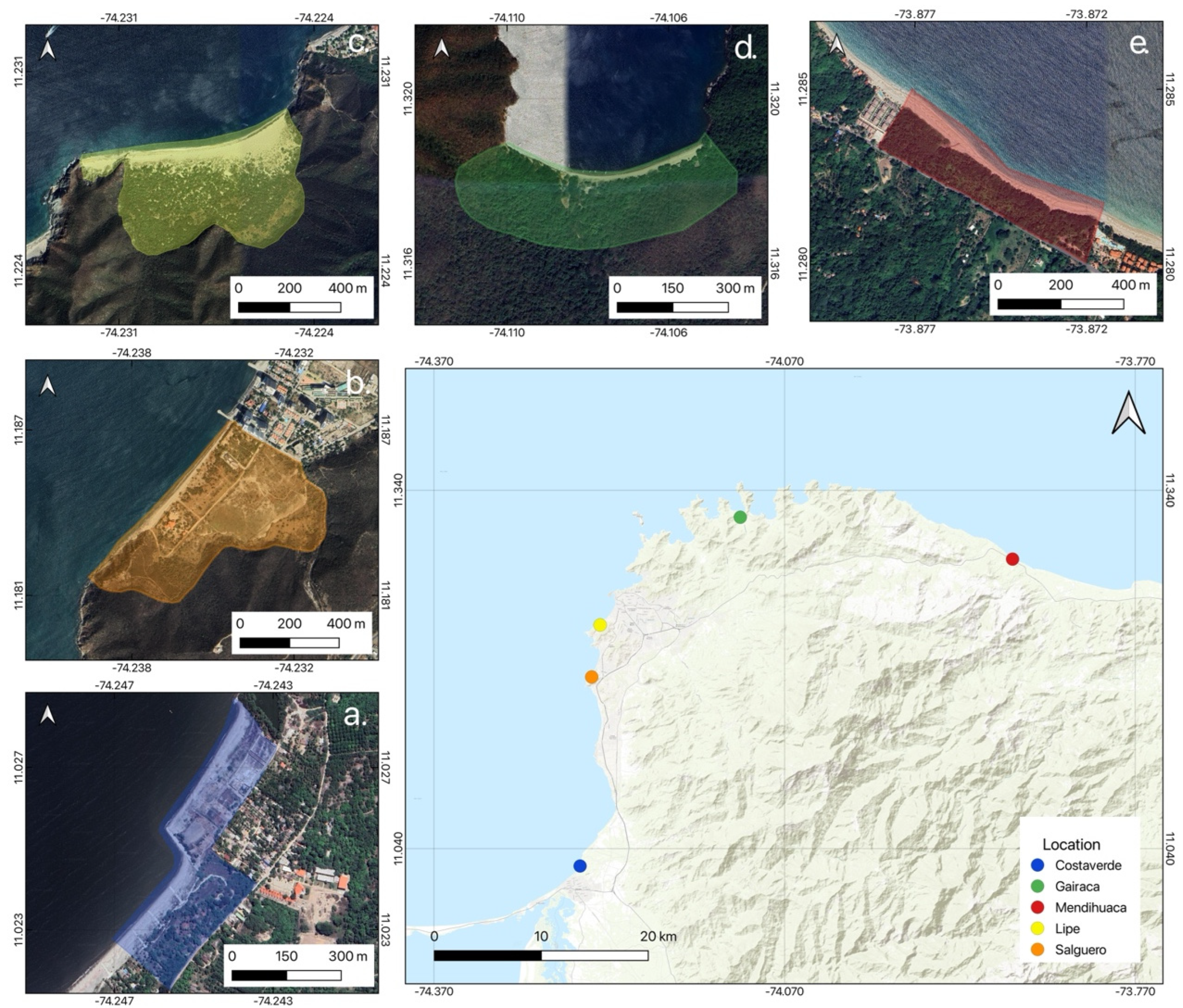
Figure 2.
Temporal dynamics of median SAVI values in five coastal dune ecosystems of the Colombian Caribbean during the 2015–2025 monitoring period. Colored lines represent annual median SAVI values for Costa Verde, Gairaca, Lipe, Mendihuaca, and Salguero. Background shaded intervals correspond to dominant ENSO climatic phases, including El Niño (pink) and La Niña (blue), to facilitate visualization of potential climatic influences on vegetation cover variability.
Figure 2.
Temporal dynamics of median SAVI values in five coastal dune ecosystems of the Colombian Caribbean during the 2015–2025 monitoring period. Colored lines represent annual median SAVI values for Costa Verde, Gairaca, Lipe, Mendihuaca, and Salguero. Background shaded intervals correspond to dominant ENSO climatic phases, including El Niño (pink) and La Niña (blue), to facilitate visualization of potential climatic influences on vegetation cover variability.
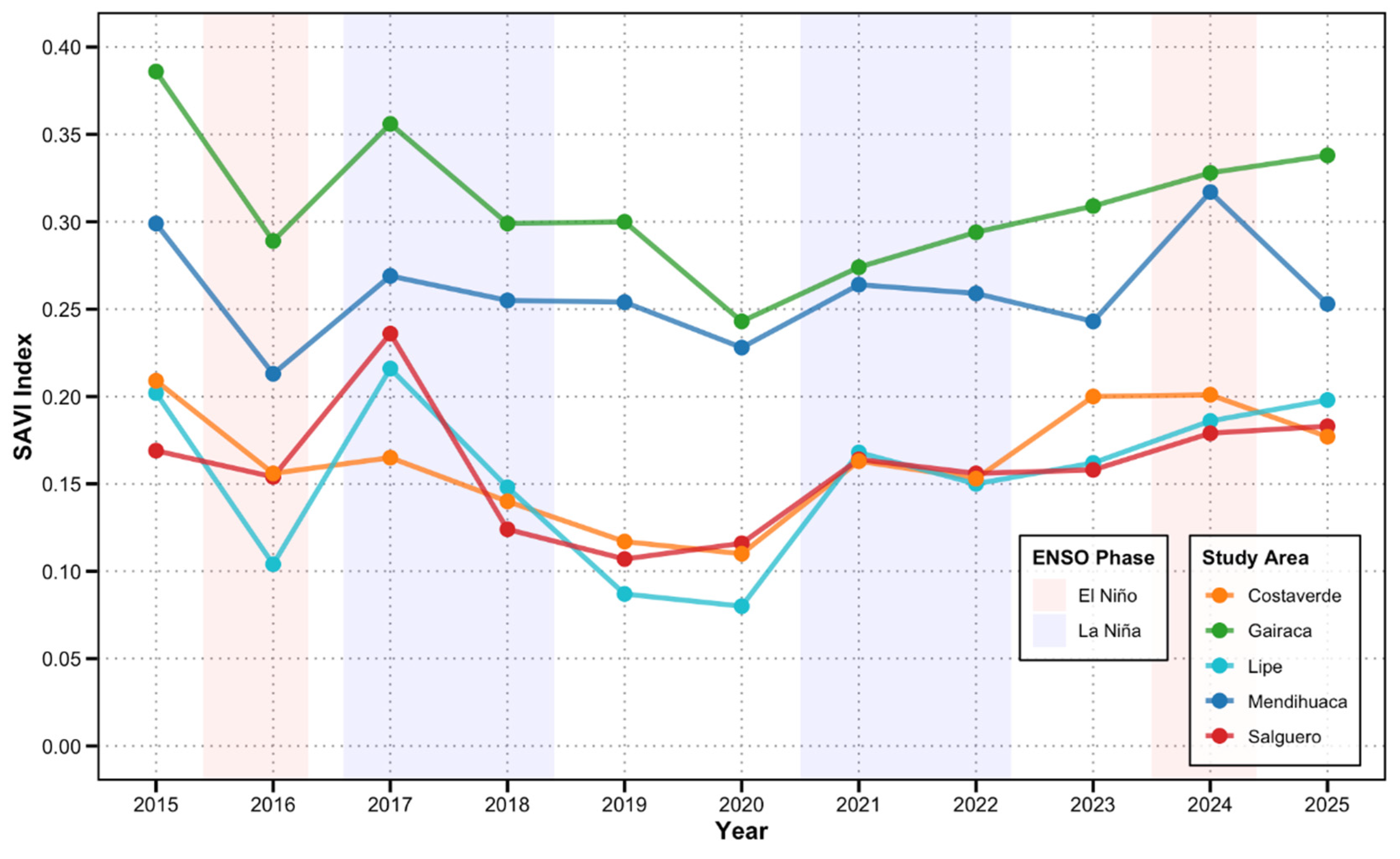
Figure 3.
Proportional redistribution of SAVI-derived successional seral stages between 2015 and 2025 across five monitored coastal dune systems. Stacked bars represent the percentage cover occupied by bare soil, sparse vegetation, moderate vegetation, and dense vegetation classes, as defined by the hierarchical SAVI threshold model. Changes in class proportions illustrate the degree of dune stabilization, vegetation consolidation, or persistence of mobile sand conditions over the monitoring decade.
Figure 3.
Proportional redistribution of SAVI-derived successional seral stages between 2015 and 2025 across five monitored coastal dune systems. Stacked bars represent the percentage cover occupied by bare soil, sparse vegetation, moderate vegetation, and dense vegetation classes, as defined by the hierarchical SAVI threshold model. Changes in class proportions illustrate the degree of dune stabilization, vegetation consolidation, or persistence of mobile sand conditions over the monitoring decade.
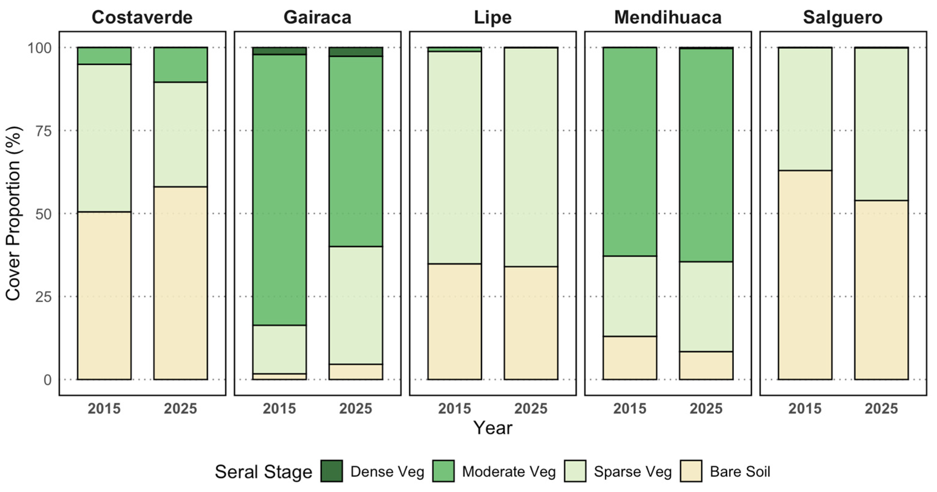
Figure 4.
Spatial balance of successional gain and loss areas detected from the SAVI-based transition analysis between 2015 and 2025 across five monitored coastal dune systems. Blue bars represent areas exhibiting positive vegetation transitions (Gain), whereas red bars indicate sectors undergoing vegetation regression or cover loss (Loss). Values are expressed as thousands of square meters (103 m2). The figure highlights strong differences in the magnitude and direction of spatial vegetation reorganization among dune systems, revealing contrasting patterns of degradation, stability, and recolonization.
Figure 4.
Spatial balance of successional gain and loss areas detected from the SAVI-based transition analysis between 2015 and 2025 across five monitored coastal dune systems. Blue bars represent areas exhibiting positive vegetation transitions (Gain), whereas red bars indicate sectors undergoing vegetation regression or cover loss (Loss). Values are expressed as thousands of square meters (103 m2). The figure highlights strong differences in the magnitude and direction of spatial vegetation reorganization among dune systems, revealing contrasting patterns of degradation, stability, and recolonization.
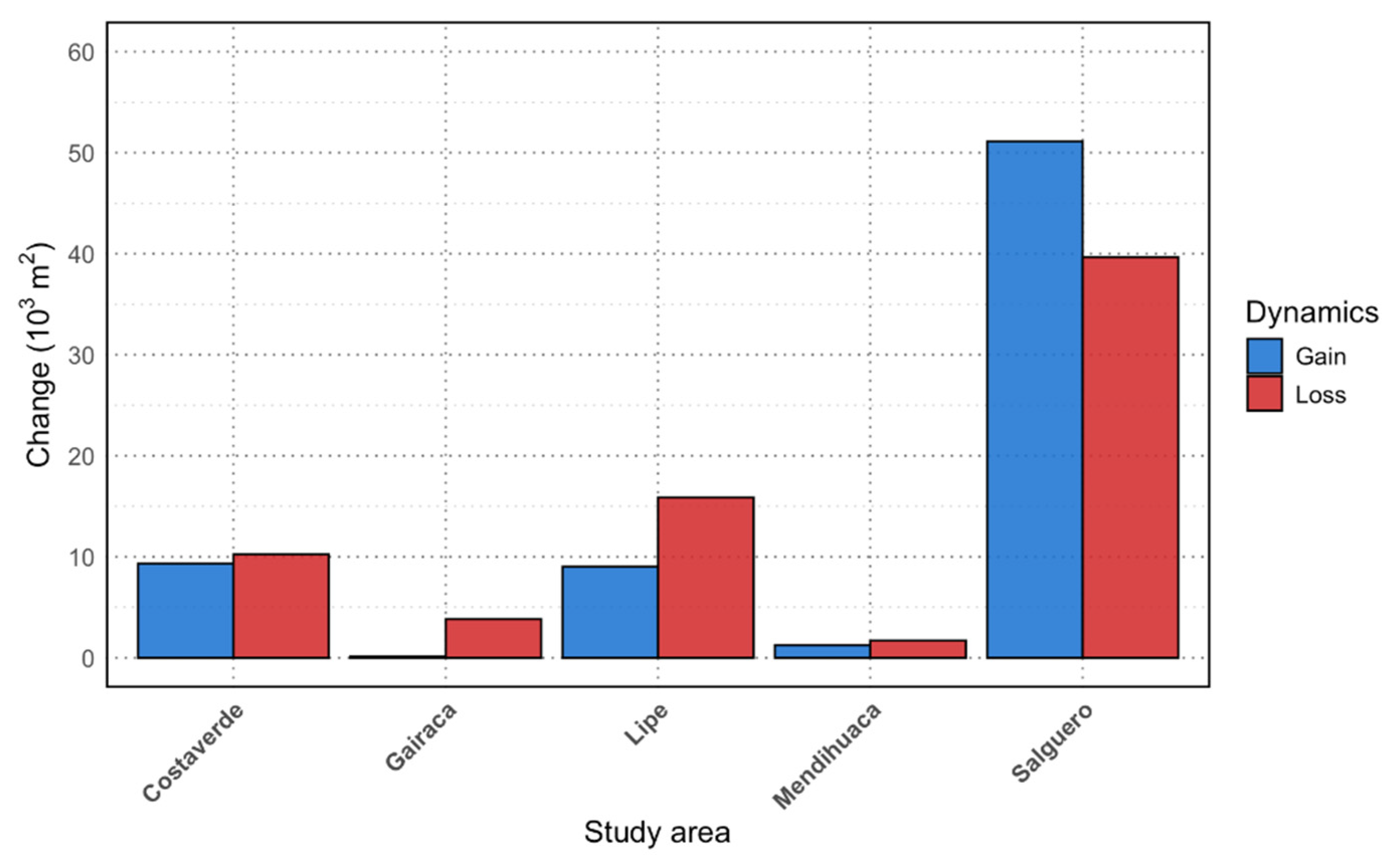
Figure 5.
Multivariable eco-geomorphological resilience ranking of five monitored Caribbean coastal dune systems based on normalized structural, climatic, and successional indicators. Radar axes integrate seven resilience-related variables, including mobile sand stabilization, low severe degradation, geomorphological stability, thermal buffering capacity, moisture retention, annual SAVI trend, and dense vegetation persistence. Larger polygonal areas indicate greater overall ecological resilience and higher dune system consolidation.
Figure 5.
Multivariable eco-geomorphological resilience ranking of five monitored Caribbean coastal dune systems based on normalized structural, climatic, and successional indicators. Radar axes integrate seven resilience-related variables, including mobile sand stabilization, low severe degradation, geomorphological stability, thermal buffering capacity, moisture retention, annual SAVI trend, and dense vegetation persistence. Larger polygonal areas indicate greater overall ecological resilience and higher dune system consolidation.
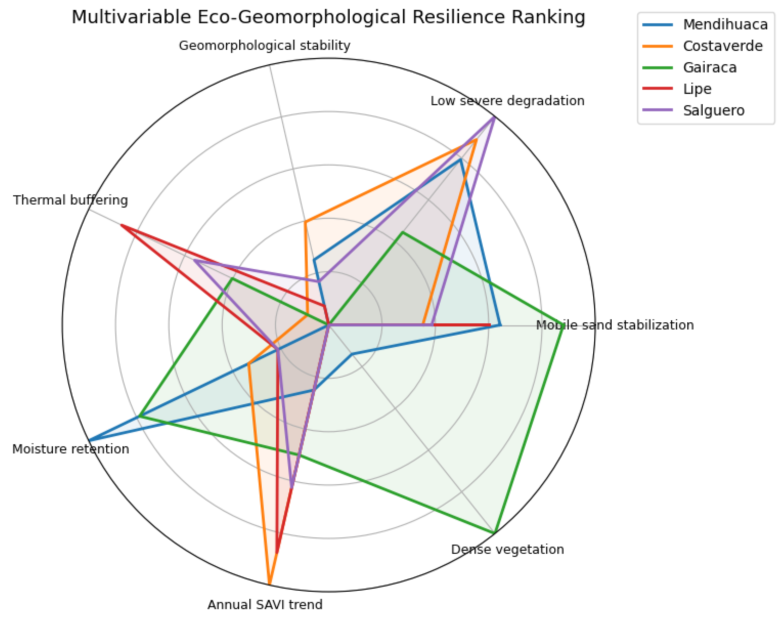

Table 1.
Hierarchical classification of successional seral stages based on SAVI thresholds and their corresponding eco-geomorphological characteristics.
Table 1.
Hierarchical classification of successional seral stages based on SAVI thresholds and their corresponding eco-geomorphological characteristics.
| Stage | SAVI Threshold | Eco-geomorphological Characteristics |
|---|---|---|
| Bare Soil | SAVI < 0.2 | Areas of mobile sand with high rates of aeolian transport. Inhospitable to most vascular plant life due to extreme substrate instability and sand abrasion. |
| Sparse | 0.2 ≤ SAVI < 0.35 | Early stages of primary succession. Dominated by prostrate pioneer plants and rhizomatous grasses that initiate the process of biogenic accretion. |
| Medium | 0.35 ≤ SAVI < 0.5 | Transitional community. Organic matter accumulation and moisture retention allow for the establishment of subshrubs and dwarf shrubs. |
| Dense | SAVI ≥ 0.35 | Local climaxes or dense coastal scrublands. The microclimate is fully regulated by the plant’s canopy, and the underlying substrate is structurally consolidated. |
Table 2.
Consolidated synthetic metrics of SAVI temporal dynamics and ecological resilience across five coastal dune systems of the Colombian Caribbean (2015–2025).
Table 2.
Consolidated synthetic metrics of SAVI temporal dynamics and ecological resilience across five coastal dune systems of the Colombian Caribbean (2015–2025).
| Index | Gairaca | Mendihuaca | Costaverde | Lipe | Salguero |
| SAVI 2015 | 0.39 | 0.3 | 0.21 | 0.2 | 0.17 |
| SAVI 2020 | 0.24 | 0.23 | 0.11 | 0.08 | 0.11 |
| SAVI 2025 | 0.34 | 0.25 | 0.18 | 0.2 | 0.18 |
| Net change 2015–2025 (ΔSAVI) | -0.05 | -0.05 | -0.03 | 0 | 0.01 |
| Maximum SAVI | 0.39 | 0.32 | 0.21 | 0.22 | 0.24 |
| Minimum SAVI | 0.24 | 0.21 | 0.11 | 0.08 | 0.11 |
| Interannual amplitude | 0.15 | 0.11 | 0.1 | 0.14 | 0.13 |
| Mean SAVI (2015–2025) | 0.31 | 0.26 | 0.16 | 0.15 | 0.16 |
| Temporal CV (%) | 13.8 | 10.7 | 18.9 | 26.4 | 21.7 |
| Recovery gain 2020–2025 | 0.1 | 0.02 | 0.07 | 0.12 | 0.07 |
Table 3.
Integrated ecological interpretation of temporal vegetation vigor and spatial successional transitions across five coastal dune systems of the Colombian Caribbean.
Table 3.
Integrated ecological interpretation of temporal vegetation vigor and spatial successional transitions across five coastal dune systems of the Colombian Caribbean.
| Study area | Gairaca | Mendihuaca | Costaverde | Lipe | Salguero |
| Mean SAVI (2015–2025) |
0.31 | 0.26 | 0.16 | 0.15 | 0.16 |
| Temporal CV (%) | 13.8 | 10.7 | 18.9 | 26.4 | 21.7 |
| Net SAVI trend | Slight decline | Slight decline | Moderate decline | Neutral | Slight increase |
| Gain area (103 m2) | 0.2 | 1.2 | 9 | 9 | 51 |
| Loss area (103 m2) | 4 | 1.8 | 10 | 16 | 40 |
| Net spatial balance | -3.8 | -0.6 | -1 | -7 | 11 |
Table 4.
Summary of ecophysiological, geomorphological and space-temporal dynamics metrics for dune ecosystems in the five study areas (2015-2025). Integrated eco-geomorphological resilience indicators derived from SAVI transitions, thermal-hydric feedbacks, and vegetation structural stability across five Caribbean coastal dune systems.
Table 4.
Summary of ecophysiological, geomorphological and space-temporal dynamics metrics for dune ecosystems in the five study areas (2015-2025). Integrated eco-geomorphological resilience indicators derived from SAVI transitions, thermal-hydric feedbacks, and vegetation structural stability across five Caribbean coastal dune systems.
| Study Area | Mobile Sand (%) | Severe Degradation (m2) | Geomorphological Instability | LST Stable Veg (°C) | LST Loss Zone (°C) | NDMI Stable Veg | NDMI Loss Zone | Total Surface (m2) | Annual SAVI Trend | Dense Veg (%) |
|---|---|---|---|---|---|---|---|---|---|---|
| Mendihuaca | 35.72 | 185.88 | 0.072 | 30.95 | 31.97 | 0.33 | 0.14 | 131,630.98 | 0.002 | 0.43 |
| Costaverde | 64.72 | 100.00 | 0.058 | 37.45 | 38.38 | 0.11 | -0.04 | 136,448.63 | 0.008 | 0.00 |
| Gairaca | 11.95 | 500.00 | 0.096 | 32.09 | 31.48 | 0.26 | 0.12 | 154,297.26 | 0.004 | 3.08 |
| Lipe | 39.81 | 900.00 | 0.089 | 38.40 | 38.26 | 0.07 | -0.03 | 310,078.82 | 0.007 | 0.00 |
| Salguero | 61.37 | 0.00 | 0.080 | 38.23 | 37.78 | 0.07 | -0.02 | 349,418.04 | 0.005 | 0.00 |
Disclaimer/Publisher’s Note: The statements, opinions and data contained in all publications are solely those of the individual author(s) and contributor(s) and not of MDPI and/or the editor(s). MDPI and/or the editor(s) disclaim responsibility for any injury to people or property resulting from any ideas, methods, instructions or products referred to in the content. |
© 2026 by the authors. Licensee MDPI, Basel, Switzerland. This article is an open access article distributed under the terms and conditions of the Creative Commons Attribution (CC BY) license.
Copyright: This open access article is published under a Creative Commons CC BY 4.0 license, which permit the free download, distribution, and reuse, provided that the author and preprint are cited in any reuse.