

Submitted:
26 May 2026
Posted:
27 May 2026
You are already at the latest version
Abstract
This article examines how Rondônia's territory changed in the early 21st century, focusing on “matogrossization,” a process reflecting the spread of Mato Grosso's productive practices due to agribusiness expansion, especially soybean and corn monocultures. This led to a major reorganization of the regional agrarian space, with commodity exports sparking a land rush and intensive deforestation. The process caused conflicts over land, resistance from local peasants and Amazonian peoples, rural depopulation, and urban growth, driven by rural-to-urban migration. “Matogrossization” explains these socio-spatial shifts, linking Rondônia to global agribusiness and its environmental impacts.
Keywords:
Amazon
; commodities
; peasant struggles
; Rondônia
; social resistances
1. Introduction
The social and environmental sciences have increasingly demonstrated the socioeconomic, politico-cultural, environmental, and territorial impacts the Amazon has experienced over this long period of economic modernization, which began in the 1960s. Some issues related to territorial changes and economic and environmental impacts remain equally relevant at the beginning of the twenty-first century, as large infrastructure projects tend to modify the endogenous coherences of places in the region[1,2] .
Agro-pastoral, forestry, mineral, and energy expansion are key economic drivers that turn nature into resources and facilitate capital accumulation. Agricultural settlement often leads to precarious urbanization and vulnerable living conditions. Scholars have described these changes through concepts like “pioneer fronts,” inspired by Pierre Monbeig, and the broader “frontier” idea [3], used by geographers, sociologists, anthropologists, economists, political scientists, military officials, and historians. These concepts generally refer to transforming nature into agro-pastoral space, interiorizing settlement, and emphasizing primary production in regional economies.
Over the past six decades of economic growth, the meaning and scope of regional change have evolved. Multidimensionality and temporal differences create distinct local variations in economic interventions and territorial claims. There is a gradual shift in the frontier concept since the 1970s, from focusing on agro-pastoral-mineral resources and migration to new socio-geographic realities in the social imaginary. This led to pioneer theories on settlement and urbanization, and the use of deforestation as an aesthetic of economic progress.
Current observations show that the expansion of agricultural and mineral commodities drives territorial restructuring in the region. This process is a metaphorical “territorial modeling of agribusiness”—a flattening or crushing of the Amazonian landscape [4]. This aesthetic manifests in the geometry of monocultures, rural depopulation, and successive invasions of protected territories and undesignated public forests. The nature crushed by agribusiness machinery ultimately separates the land from the forest, producing the commodities of “agricultural land” and “pasture area” that define the Brazilian land market. In this sense, the shift in political content and meaning introduces a “commodity frontier,” characterized by an inextricable link to the international market and the economic and political verticalities of dominant agribusiness agents [5]. This is evident in Matopiba (North and Northeast) and Amacro (Western Amazon), considered Brazil’s two globalized agricultural frontiers[6].
The scale of production, agrarian conflicts, and regional realities are changing. This text examines the process of reconfiguration in Rondônia. As a theoretical premise, I term the structural socio-geographic transformations characterized by agribusiness expansion in the early twenty-first century “matogrossization,” which requires understanding the new logic of territorial use[7].
Global economic dynamics influence territorial appropriation through new international market demands for commodities. In turn, the actions of economic agents—driven by government policies that expand subsidies for globalized productive activities—exert increasing influence over territorial restructuring, intensifying export-oriented agricultural expansion.
Given the broad set of variables and processes that shape socio-geographic change, I have structured the text into three analytical axes: i) The emergence of engineering systems that enhance territorial fluidity[5,8,9], which have increased soybean expansion into previously remote or irrelevant areas.; ii) The territorial dynamics and matogrossization of Rondônia are based on recent agro-pastoral changes, capital’s territorial logic, and rural population shifts [3,10]; and iii) Agrarian conflicts and territorial rights in southern Rondônia [11], key to analyzing capital strategies concerning the peasantry and Indigenous peoples, focus on land disputes. The following final considerations outline the processes that shape the regional and agrarian geography of Rondônia.
2. Materials and Methods
To analyze territorial dynamics in the Amazon, particularly in the state of Rondônia, I integrate a human and regional geography approach [7,12] with statistical and cartographic analysis. This methodology combines IBGE census data with geospatial data to produce thematic maps. The research focuses on Rondônia, located in the Brazilian Amazon (North region), with a territory of 237,765.347 km². Its urban network comprises 52 municipalities, with a population of 1,581,196, an urbanization rate of 78.53%, and a demographic density of 6.65 inhabitants/km² [13].
Rondônia achieved political emancipation in 1981, making it one of the more recent states in Brazil’s territorial organization. Between 1970 and 1990, agricultural colonization was the primary public policy for distributing land to migrants, establishing a land tenure structure with a strong presence of family farming (smallholdings). During this period, land use shifted significantly, including agro-pastoral expansion, a growing land market, and, in the twenty-first century, the expansion of export monocultures such as soy, corn, and beef (cattle). Regarding ranching, Rondônia maintains a cattle herd of 18,221,984, ranking sixth among national producers and representing 7.65% of the Brazilian herd [14].
Between 1985 and 2024, Rondônia’s deforestation reached 40% of its total area, driven by the expansion of monocultures and ranching [15]. The surge in agricultural commodity prices triggered a “land rush” in Rondônia, leading to numerous agrarian conflicts. Notable among these is the 1995 Corumbiara massacre, which killed nine peasants—including a seven-year-old child—and two military police officers[16]. In the second part of the analysis, I focus on the Corumbiara region in southern Rondônia, specifically the Tanaru Indigenous Territory[17], which faces mounting pressure from agribusiness expansion.
Data for cartographic development and qualitative analysis were obtained from public sources recognized for their credibility and for providing up-to-date geospatial information, as shown in Table 1:
The section “Amazon, Territorial Fluidity, and Commodity Logistics” analyzes agribusiness engineering systems. It prioritizes the main highways, waterways, and ports that facilitate the flow of agribusiness cargo (soy and corn) in the Amazon, highlighting the BR-319 axis in the soy-producing regions of Mato Grosso and western Pará.
Another axis comprises the BR-364 and the Madeira Waterway, enabling the territorial fluidity of grain production from western Mato Grosso and throughout Rondônia. The Madeira Waterway connects the ports of Porto Velho—home to Cargill and Amaggi facilities—to the port of Itacoatiara (Amazonas), where Amaggi operates large-ship transshipments, and to Santarém (Pará), where Cargill handles transshipments for international markets.
These two logistical axes reveal the organization of agribusiness engineering systems. Spatial displacement begins in Mato Grosso, moving northward into western Pará, and, in the southern Amazon, shifts from western Mato Grosso into Rondônia. Currently, 38 municipalities in Rondônia produce soy (86% of the state’s total)[14,18].
The section “Agrarian Conflicts and Territorial Rights in Question” examines the southern region of Rondônia. In the municipality of Corumbiara, I focus on the Tanaru Indigenous Territory, which faces pressure from agribusiness expansion. In this region, agrarian conflicts have shaped both its history and geography. The area features large rural properties, peasant settlements (smallholders), and expanding soy and cattle production. The expansion of soy initiated the process of “matogrossization” in Rondônia, as the rural landscape gradually shifted toward monocultures, leading to the demographic emptying of Rondônia’s rural areas[16]. The expansion of commodity production inevitably pressures protected areas, such as the Tanaru Indigenous Territory—a situation that crystallizes disputes over land and territory within Rondônia’s agrarian geography[19].
3. Results
3.1. Amazon, Territorial Fluidity and Commodity Logistics
Soybean production stands out as a primary global commodity in the first quarter of the twenty-first century. Markets in China, Southeast Asia, the European Union, and Mexico drive demand. A select group of major producers—including Brazil, the United States, Argentina, China, India, and Paraguay—participates in this multiscalar and globalized economy. This dynamic reshapes emerging production regions and impacts territorial cohesion[20]. Geographic fragmentation emerges as a hallmark of globalization, rendering agricultural regions more susceptible to external flows and exogenous political mandates [6,8,21].
In Brazil, favorable climates, topography, and technological advancements drove the expansion of soybean production. Mechanization and increased productivity gains complemented this growth [22], beginning with the opening of agricultural areas in the South during the 1970s. By the 1980s, expansion reached the Center-West, increasing its share of national production from 2% to 20%. This process gradually shifted from the South to Mato Grosso, Mato Grosso do Sul, and Goiás, concentrating national production within the country’s Center-South [14].
By 2024, production was concentrated primarily in Mato Grosso (27%), Paraná and Rio Grande do Sul (13%), Goiás (12%), Mato Grosso do Sul (8%), and Minas Gerais and Bahia (5%). Together, these states represent 82% of national output [14]. Brazil has led the global ranking as the largest soybean producer since 2019, surpassing the United States and accounting for approximately 40% of world production. However, agricultural and mineral commodity production requires engineering systems to ensure territorial fluidity, which modifies the territory’s organic composition through technical densities [5,9,23].
To facilitate commodity flows, the State expands infrastructure and logistics investments, which alter the territory’s composition, increasing fluidity and specialization[8]. This trend, seen in globalized agribusiness regions [24], enhances national trade participation and adds value to regional chains. Regional and global logistics systems reduce costs, boost service efficiency, and maximize profits, serving as key competitive advantages for economic agents.
Large agribusiness trading and agricultural firms increasingly control monoculture production in Northern and Northeastern Brazil. These entities open new fronts for globalized agribusiness, epitomized by the formation of the Matopiba region. In the Amazon, soybean production continues to grow in Pará, Rondônia, and Roraima, and to a lesser extent in eastern Acre and southern Amazonas. Expansion originating in Mato Grosso directly impacts these states [4,25]. This dynamic suggests the formation of peripheral agricultural regions within the globalized economy or, in Miltonian terms, the creation of “globalization spaces” [21,26].
Regarding Amazonian logistics, the primary routes for exporting soy and its derivatives include the Northern export corridor, which utilizes highways such as BR-163, BR-158, BR-135, BR-364, and BR-242. Other vital routes include the North-South Railway, the Carajás Railway, and the Madeira, Amazonas, and Tapajós waterways [27]. Pressure for new engineering systems (fixed assets and flows) originates in Mato Grosso (northwest, north, and mid-north regions). This pressure creates openings in western Pará (Santarém), Rondônia (Porto Velho), southern Amazonas (Humaitá) [28], and other riverside municipalities along the Madeira axis in Amazonas (Figure 1).
In grain transport operations, a partial loss of competitiveness prompted measures to create routes leading to port centers in the Amazon and the Northeast. For example, the Maggi Group utilizes its subsidiary Hermasa S.A. and a river terminal in Porto Velho to transport soybeans via the Madeira and Amazonas rivers to Itacoatiara (Amazonas). Conversely, Cargill invested in terminals in Porto Velho (Rondônia) and Santarém (Pará). Santarém stands out for its strategic location at the convergence of the highway (BR-163) and waterway axes. This positioning facilitates the flow of production from the Nova Mutum-Sorriso region in the state of Mato Grosso [21,29].
The arrangement formed by these flows reveals three primary routes for grains traveling from Mato Grosso to the Amazon: I) transport between the production area and grain ports in Porto Velho (Amaggi, Bertolini, Cargill) and Humaitá (Masutti), with distances exceeding 800 kilometers; II) a railway route via the North-South Railway, with displacements exceeding 1,600 kilometers toward the ports of Itaqui/MA or Santos/SP; and III) the path connecting the production area along the Cuiabá-Itaituba axis (BR-163), involving highway displacements ranging from 760 to 1,200 kilometers.
All these projects aim to consolidate logistics within the Northern region[30]. Consequently, public and private actors implement measures to enhance strategies within export corridors. These efforts include established routes, such as the Madeira Waterway from Porto Velho (Rondônia), and emerging opportunities, particularly the Tapajós Waterway accessible via BR-163 toward Santarém (Pará). New logistics systems based on intermodality are gradually incorporating ports such as Vila do Conde in Barcarena (Pará) and Santana (Amapá). This integration stems from the new engineering systems constructed at these strategic points within global flows [31,32].
Amazonian grain ports are part of the logistics complex known as the Northern Arc (Arco Norte)[33]. This geographic area encompasses ports in the Northeast (Ilhéus and Itaqui) and the Northern region (Barcarena, Santana, Santarém, Itacoatiara, Novo Remanso, Manaus, Humaitá, and Porto Velho). The Northern Arc represents an extensive network focused on cargo transport, primarily commodities such as grains and ores. Currently, the emergence of new export routes is converting Amazonian roads and rivers into corridors for the export of grains and other products linked to global production chains [27].
The Amazon Northern Arc Project (Projeto Arco Norte Amazônia—PANA), which covers part of the Northern Arc, serves as a representative expression of multimodal logistics corridors[34]. Essentially, these initiatives expand territorial fluidity to facilitate the export of raw materials. Various agents at global and federal scales conceive of these projects. The World Bank acts as one such global agent, while the Federal Government plays a fundamental role by allocating resources for public works related to circulation and transport. Across these groups, particularly at national and regional scales, the Northern Arc aims to maximize competitive advantages. These efforts reduce the cost of transporting bulk cargo within Brazilian territory and to the external market[30,33,34] .
3.2. Territorial Dynamics and the “Matogrossization” of Rondônia
Territorial dynamics are understood as a “geographical notion that corresponds to the movement of society registered in the territory as an element that brings significant and also structural changes, presenting a genetic-structural content”[3,12]. Based on this conceptualization, Costa Silva[3] identifies two structural moments in Rondônia’s geography between 1970 and 2010. These moments modeled territorial use through distinct yet interchangeable processes, allowing for a reading of past eras within contemporary socio-spatial formation.
From 1970 to 1995, i) the State acted as the predominant public agent in territorial organization, agricultural colonization, and urban expansion through the interiorization of settlement, agro-pastoral growth, and environmental policies. These processes defined the axes of the new spatial organization, distancing it from the ancient river-based settlement axis (1900 to 1970). That previous era centered on the Guaporé, Mamoré, and Madeira rivers and was a byproduct of the legendary construction of the Madeira-Mamoré Railway and the exploitation of rubber[7].
In the subsequent period (1995–2010), ii) economic geography shifted toward the BR-364 highway axis, particularly in the Central region—marked by the rise of Ji-Paraná—and further south in the cities of Cacoal and Vilhena. This period featured the territorial insertion of agribusiness (soy, corn, and meat for export), distinguishing it from other agricultural economies. Consequently, agro-export capital emerged as a regional and global economic agent, leading to the productive specialization of the territory [8]. This formed the first agricultural regionalization characterized by the spatialization of soybeans in the southern cone of Rondônia[3,23].
In the early twenty-first century, territorial configurations have changed significantly through the spatialization of agribusiness, regulated by globalized agricultural expansion and anchored by three products: soybeans, corn, and beef. Additionally, a land market has emerged within a “rush” for new rural areas, currently observed in northern and northwestern Rondônia and shifting toward southern Amazonas and eastern Acre[2,35].
I term this emerging framework of structural changes “matogrossization.” This process manifests in the territorial reconfiguration of Rondônia’s agrarian space, centered on agribusiness expansion (soy and corn), the formation of peripheral agricultural regions within the national economy, alterations to the Amazonian landscape, the escalation of agrarian and territorial conflicts, and a declining rural population alongside urban demographic growth. These socio-geographic transformations tend to link Rondônia as a “capture area” for agribusiness originating in Mato Grosso. For this text, I will analyze the spatiality of agribusiness and its territorial impacts.
I begin with agricultural data representing this regional shift. Since 1997, soybeans, in association with corn, have emerged as the first monoculture to modify Rondônia’s agrarian space, serving as the empirical expression of agribusiness [21]. Regarding planted area (hectares) between 2000 and 2024, the agrarian landscape recorded a general decline in daily food staples such as rice, coffee, and beans, with decreases of 57%, 76%, and 97%, respectively. Conversely, corn and soybeans grew by 169% and 5,355% during the same period. A similar trend occurred in production quantity (tons), as rice (-5%), coffee (-18%), and beans (-97%) showed reductions. Beans have virtually vanished from Rondônia’s agricultural framework, dropping from 49,751 tons in 2000 to just 1,356 tons in 2024 [14]. Generally, rural settlements—some organized by the Landless Workers’ Movement (MST) produce the state’s bean crop.
The situation is inverted for corn and soybeans—associated monocultures—whose yields increased by 743% and 6,033%, respectively, reaching 1,721,713 and 2,221,610 tons. To grasp the scale of commodity production in this period, compared to coffee, the latter totaled 48,267 hectares and 170,232 tons produced in 2024[14]. This growth means that, in terms of planted area alone, soybeans grew thirteen times more than the primary product of family farming. An overwhelming occupation of soybeans occurs in areas available for purchase or lease by large economic groups[36], constituting a new and selective race for land.
Average production yield (kg/ha) reflects technological advances driven by government and corporate investments, leading to productivity growth across all crops: 122% for rice, 239% for coffee, 25% for beans, 214% for corn, and 14% for soybeans during this period. As soybeans dominate the agricultural economy and grow due to new engineering systems enhancing territorial fluidity[9], more land is likely added to production. This expands the agricultural frontier into northern and northwestern Rondônia and southern Amazonas, increasing deforestation and invasions of public forests.
The corporate use of territory[8] emerges as a process of economic and land concentration within regional geography, serving as a structural fact in agrarian geography by revealing the territorial logic of large companies. In the 2012/2013 harvest, the framework covered 694 properties across 157,000 hectares of soy. By the 2021/2025 harvest, 2,104 properties were responsible for 460,000 hectares of soy[37]. According to Idaron[38], approximately 4,600 properties exist, with an estimated planted area of 687,157.91 hectares. Compared to coffee, the primary product of family farming, there were 23,483 rural establishments producing coffee in 2017, with a harvested area of 55,120 hectares [14,18]. A 12-fold difference in area favors the soybean agribusiness. It is common for a soybean owner to hold other properties or leases, as an individual or through an associated business, which highlights land concentration and a reduction in the number of economic agents. During field research in the Vilhena region, intersubjective dialogues frequently revealed that rural producers held their own, leased, or associated agricultural areas in other municipalities, such as Cerejeiras and Corumbiara (South), or the Ariquemes and Porto Velho regions (North)[39].
In comparison, coffee is an agricultural crop produced by the peasantry with strong insertion into the regional economy, primarily due to technological changes in production systems encouraged by processing companies that market it nationally; this highlights peasant territoriality involving thousands of families in the productive and social process[40]. Grain agribusiness (soy and corn) presents itself as a concentrated industry with exclusionary practices across regional geography. The analyses by Fernandes et al. [37] correctly link soybean expansion with environmental and territorial impacts in Rondônia:
i) “the average area of soybean cultivation exceeds the average area of the properties comprising the state’s land structure”;
ii) “soybean expansion eventually occupies spaces previously dedicated to cattle ranching, which results in the displacement of cattle to new areas formerly covered by forests”;
iii) “expansion occurs through the aggregation of properties that often belong to different owners”;
iv) “to compensate for this substitution, new pastures are established on recently deforested lands”;
v) “this advancement puts pressure on protected areas, resulting in the overlapping of rural properties onto Indigenous lands and other conservation areas.”
The spatialization of soybeans creates territorial fragmentations in peripheral agricultural regions that generate demand for new areas, pressuring protected territories and public forests. Hegemonic agribusiness agents see protected areas as “space-stock” [41] to expand their operations. Capital expands mainly through land incorporation due to limited productivity, increasing demand for new soybean areas[36]. Another impact is land concentration in peripheral regions, which expels rural populations[37].
Therefore, in the regional panorama, the heritage of agricultural colonization in Rondônia (1970–1990)—when the land structure featured significant participation by the peasantry or small properties—is partially modified. Soybean expansion and rising land prices are factors in the decline of Rondônia’s rural population. Furthermore, the formation of peripheral agricultural regions of the national economy indicates a movement of regionalized land concentration, peasant expropriation, and the weakening of family farming.
One can understand the process of “matogrossization” in Rondônia through the sharp decline in the rural population, which serves as a robust indicator of agrarian territorial transformations. The results of the 2022 Demographic Census indicated that Rondônia was one of the Brazilian states showing stabilization during the intercensal period (2010–2022); that is, the population barely grew. However, the decrease in the rural population impacted the overall result. While Rondônia’s population grew by 1% over 12 years, a significant difference emerged between the urban population, which grew by 8%, and the rural population, which decreased by 18%[13].
Numerous issues can be analyzed in demographic dynamics, including the composition of municipalities, the distribution of urban and rural populations, intra-state and intra-regional migration, fertility rates, the age pyramid, and the dynamics of the agricultural frontier in Rondônia itself. However, the partial results for the rural population deserve highlighting. Of the fifty-two municipalities in the state of Rondônia, the population failed to grow in 38 (73%). When differentiated by territorial level, the urban population grew in 30 municipalities (58%), while the rural population declined in 46 municipalities (88%). The range of rural population data varied from -1% to -52%, revealing expropriation, rural-to-urban migration, migration to new agricultural frontiers, and rural emptying in some regions of Rondônia[10]. The phenomenon of abandoned houses and the numerous closures of rural schools serve as indicators of this process.
When analyzing the agrarian space in Rondônia in this first quarter of the twenty-first century—related primarily to the globalized economy driven productively and territorially by the soybean agribusiness—one concludes that the formation of peripheral agricultural regions of national agribusiness, the expropriation of the rural population, and monocultures institute new logics of territorial appropriation. These logics distance themselves from previous processes of agricultural colonization. If in the past Rondônia received thousands of migrant families, primarily for rural areas, today it expels the rural population. It is now demarcated by the geometry of grains, monocultures, a depopulated countryside, and agrarian conflicts—veritable landscapes foreign to the Amazon.
3.3. Agrarian Conflicts and Territorial Rights in Question
Agrarian conflicts result from the mechanisms of primitive accumulation and peasant expropriation in the Amazon. For large corporations—the hegemonic agents—spoliation is a necessary condition for expanded reproduction[42]. Both deforestation and the grabbing of public lands (grilagem) exemplify these mechanisms. They serve the expansion of the agricultural frontier, which, under globalization, manifests as neo-extractivism and deterritorialization. Agrarian conflicts crystallize class struggles and social group tensions, intensifying as capital expands territorial and environmental spoliation[43].
In the current Amazonian context, specific factors characterize agrarian conflicts: the geographical scale of these relations, the “stock” of public lands (whether designated or not) available for agro-pastoral appropriation, and the deterritorialization of the peasantry and traditional communities. This last process directly undermines their territorial and human rights[44,45].
Geographical scale, as an analytical resource, represents the political relationship (actions) that society or agents maintain with a disputed space—an object of appropriation or domination[46]. This framework allows one to observe the levels and dimensions through which agents objectify their projects within the disputed geographic space (territory). Scale is “social time”[47]. Differentiating between the scale of operating forces—the scale of the agents—and the scale of the phenomenon (the geographic area of its manifestation) reveals the multidimensionality of social conflicts in the Amazonian countryside[3].
Human rights generally relate to the defense of human dignity and the material and immaterial aspects of social life that enable a dignified existence[48]. Land, territory, and nature constitute the material conditions for the dignity of human life. When men and women fight for land, territory, and nature, they affirm the inextricable link between human beings and these material and immaterial elements as a condition for human dignity[45,49].
The cartography of Brazilian agrarian conflicts reveals a country marked by violations and the struggles of peasants and traditional communities against an agricultural model that presents itself as unique, oppressive, and destructive to lives and territories. Analyzing data from the Conflitos no Campo Brasil report, produced by the Pastoral Land Commission (CPT), requires distinguishing between agrarian and territorial conflicts[42]. The former expresses conflicts over land possession, typically in areas that have been grabbed or are unproductive, currently occupied by social movements or through spontaneous occupation (unrelated to formal land-struggle organizations), as is occurring in Rondônia. The latter refers to the “defense of protected territories, where Indigenous peoples, Quilombola communities, and traditional communities express territoriality.”
According to the author:
In the first case, the situation involves the defense/struggle for land possession and access to family property; in the second, it involves federal or state public property for collective use and social reproduction. Thus, both the struggle of squatters and that of indigenous peoples and traditional communities are struggles for territories, as they express a whole collectivity founded on family work, the defense of nature, and the recognition of social and territorial rights. The collective, familial, sociocultural, and public character of peasant, Indigenous, and traditional territories contrasts with the privatist, exclusionary, deterritorializing, and monopolistic nature of capital sustained by neo-extractive economies[42].
To better analyze the social dimensions of these disputes, the CPT outlines the general category of “rural conflicts” through the following operational concepts: land conflicts, water conflicts, labor conflicts, resistance, and violence against individuals. Numerous variables provide quantitative and qualitative coherence to each concept. In 2024, Brazil recorded 2,185 rural conflicts, of which 1,768 involved land (78%). Amazon accounted for 56% of these cases. The dispute over land in the region, especially public lands, establishes it as a space for the expansion and reproduction of agro-financial capital. This expansion strikes at the territories of the peasantry, Indigenous peoples, and traditional communities[50]. Generally, between 1985 and 2023, the Amazon accounted for 44.2% of all rural conflicts, while the Center-South and Northeast accounted for 30.8% and 25%, respectively. Since 2009, the Amazonian region has led these indicators[51], becoming a region of intense disputes over land, territory, and nature.
The victims of violence and deterritorialization are social subjects who have struggled for decades for the right to land, territory, and collective life, a life not governed by the geometry of monocultures and the social logic of capital. Indigenous peoples, the landless, squatters, settlers, smallholders, and Quilombolas form a broad social group exercising multiple forms of “r-existence” in their territories, demonstrating the social diversity of the Brazilian countryside[52].
These social subjects oppose the violent hegemony of neo-extractive capital. This capital currently unifies large-scale landownership with the financial sector, bolstered by broad government support and strong alliances with media conglomerates. Agribusiness serves as the politico-territorial front for the privatization of natural resources, land concentration, and environmental pillage in the Amazon, Cerrado, and Caatinga biomes. The agribusiness economy exacerbates environmental degradation across all biomes. This reality contrasts with the advertised technological packages that highlight production, productivity, and geoeconomic scale while increasingly causing socio-environmental impacts and the deterritorialization of rural life[53]—impacts that corporate media, not associated with agribusiness, ignores.
Conflicts possess local inscriptions. They disrupt the lived territory—home, dwelling, labor, community exchanges, and the culture of social subjects for whom land and territory represent the space for life and social reproduction. The meanings of expropriation, spoliation, and what Marx called primitive accumulation position Amazon as one of the last spatial reserves for neo-extractive economies. Thus, as Monteiro[41] criticized, the region serves as a “space-stock” for capital, and as Loureiro[54] analyzed and denounced, it functions as a colony of Brazil. The situation becomes even more affronting given that, for over ten years, the Amazon has consistently ranked as the region with the most rural conflicts and the highest lethality[51].
In the geography of agrarian conflicts, the state of Rondônia has long been among the most violent and lethal for social movement leaders fighting for land and territory. Despite its small rural population and significant family farm production, this process is changing in the twenty-first century. Agribusiness growth exerts economic and territorial coercion on small properties and family farming, primarily through leasing, land purchases, and expulsion via pesticide contamination and other expropriation mechanisms.
In 2024, Rondônia recorded 132 rural conflicts affecting 54,276 people (16% of the rural population). This placed the state fourth in total conflicts in Brazil and third in the Legal Amazon. These conflicts primarily affect Indigenous peoples, the landless, and squatters. Records include 119 instances of violence against land occupation and possession, seven water conflicts, four cases of slave labor, three occupations, and one encampment. Within the “land conflict” category, 119 occurrences affected 9,472 families; 3,632 families suffered invasions, and 1,067 families faced expulsion threats or attempts. Furthermore, 624 families were victims of gun violence (pistolagem), 157 families had their homes destroyed, and 134 families saw their belongings destroyed[50].
The central question is: “Why has Rondônia become so violent against squatters, the landless, and Indigenous peoples—against the rural communities who live off the land?” As a hypothesis, I argue that the political and economic logic of territorial use has shifted. It has adopted the logic of neo-extractive economies, in which agribusiness represents the most concrete expression of expropriation, deterritorialization, and, consequently, violence.
In the twenty-first century, agribusiness operations establish territorial fragmentation. The formation of agricultural regions oriented toward external flows produces agrarian conflicts with social groups pressured by the new enclosures of agro-financial capital under the logic of global neo-extractivism. Thus, land concentration creates an “empty countryside” (campo vazio). Expropriation and migration result from the contradictions of capitalist development in the countryside. This produces a concentrated and highly publicized wealth that simultaneously expels families and deterritorializes traditional communities and Amazonian peoples.
In the past, particularly in the 1990s, the Government of Rondônia maintained a perspective on sustainable development. Concrete public policy results included the institutionalization of Socioeconomic-Ecological Zoning (ZSEE/RO)[55], the creation of dozens of Conservation Units, socio-environmental investments, and social participation in deliberative councils regarding environmental, productive, and territorial management policies.
At the turn of the twenty-first century, agribusiness—acting as both a “productive sector” and a political agent—changed the territorial agenda. This new agenda centers on monocultures, the weakening of environmental policies, gun violence, and powerful national propaganda promoting itself as the only viable agricultural model. Sustainable, productive experiences in Rondônia were displaced and stripped of public policy support, labeled as obsolete. The ideology of agribusiness as “progress and work,” as the “productive sector” that “carries” Brazil, served as a geographic ideology to expand the grabbing of public lands, environmental crimes, and invasions of protected territories.
In various speeches by state deputies during debates on environmental issues and changes to territorial zoning, pseudo-arguments such as “Rondônia is Cerrado” were common. These arguments were used to justify adjusting the ZSEE to the land demands of soybean agribusiness. Similarly, recent critiques of the soybean moratorium served to mask deforestation and the environmental crimes associated with soybean expansion. Along this path, the agribusiness agenda sought to expand monoculture from southern to northern Rondônia, reaching the banks of the Madeira River. Since 1997, the Madeira-Amazonas Waterway’s operation has boosted soybean production, gradually transforming Rondônia into a commodity frontier.
One instrument of agricultural colonization policy (1970–1980) was the use of Public Land Alienation Contracts (CATPs), which primarily benefited medium and large landowners. Through CATPs, these owners committed to investing in and developing agro-pastoral activities on properties allocated by Incra. They were required to comply with contract clauses and pay for the rural properties in reasonable installments. Evidently, many failed to comply and abandoned the lands gifted by Incra.
In the Vilhena region of southern Rondônia, squatters and the landless occupied many properties administered by CATPS. In 2017, the CPT estimated that approximately 160 rural properties in Rondônia were in this situation[56]. As land prices rose amid agribusiness growth (soy, corn, and meat), these areas became sites of agrarian conflict. The southern region, known as the cone-sul, transformed into a soybean agribusiness hub and a site of intense agrarian disputes.
In the Southern Cone, the struggle for land is one of the greatest tragedies against the peasantry—a conflict known as the “Corumbiara Massacre”[57]. Approximately six hundred families challenged the latifundia by occupying a plot on the Santa farm, an area spanning 20,000 hectares[58]. On August 9, 1995, in a botched operation and a gross violation of human rights, the Military Police spearheaded the massacre with a “task force” of three hundred men, including military officers and gunmen. “By the end of the conflict, eleven people had officially died, including a child, two police officers, and eight peasants. The results of eight autopsies on the landless workers identified gunshot wounds to the head, neck, or back at close range and from a top-down trajectory”[59]. This evidence clearly indicates execution. Consequently, because of the peasants’ struggle, Incra established the rural settlements of Zé Bentão, Alberico Carvalho, Alzira Augusto Monteiro, Renato Natan, Maranatá, and Maranatá II (Figure 2). The Corumbiara Peasant Movement (MCC) and, subsequently, the Poor Peasants’ League (LCP) were born from the aftermath of Corumbiara.
In this context, peasants and social movements fighting for land and agrarian reform faced a new political actor: globalized agribusiness. Supported by the State, corporate media, the judiciary, and sectors of society, the liturgy of “agro” established itself through violence against social movement leaders and human rights defenders. This process—characterized as “agribanditry” (agrobandidagem)—involved the appropriation of public lands through land-grabbing (grilagem) and environmental crimes to expand commodity frontiers[60].
Twenty-seven years after the Corumbiara Massacre, another multiscalar historical event gained national and international relevance in southern Rondônia. In August 2022, Funai reported the death by natural causes of the “Índio do Buraco”[61]. This news concerned the passing of the last indigenous individual of an unknown ethnicity, who inhabited the Tanaru Indigenous Territory—an 8,101.04-hectare area situated between the municipalities of Corumbiara, Chupinguaia, Parecis, and Pimenteiras do Oeste.
Official Funai records since 1973 document the presence of uncontacted or isolated indigenous peoples in southern Rondônia. Incra’s colonization projects in the Corumbiara river valley and surrounding region triggered territorial conflicts with indigenous groups, often fueled by state action[62,63]. In 1986, denunciations by the Indigenous Missionary Council (Cimi), published in local newspapers, revealed massacres and the displacement of indigenous peoples caused by road construction and the creation of large estates. These reports accused both Funai and the Federal Police of failing to act in response to violence stemming from colonization policies[64].
The Funai Ethno-Environmental Protection Front of Guaporé (FPE Guaporé) identified the “Índio do Buraco” in 1996. Funai bestowed this name based on the indigenous man’s specific practices:
The team verified that he left deep ditches (holes) in the forest, likely used for hunting animals, with sharpened stakes at the bottom. However, the most notable feature was the holes he constructed in his dwellings [...], which FUNAI believed held spiritual and religious significance[17].
A survivor of past massacres, the indigenous man lived in the Tanaru Indigenous Territory (TI), which holds the legal status of “Restricted Use.” This classification designates a demarcated and protected area inaccessible to third parties due to specific legal requirements, such as the presence of isolated people. Regarding territorial management, Funai secured this restriction only through Ordinance 1392/PRES/2012 (valid until 2015), which was renewed for an additional 10 years via Ordinance 1,040 on October 16, 2015[17].
His death signaled the “last of his ethnicity.” We thus witnessed the extermination of a people on Rondônia’s lands in the mid-twenty-first century. Yet this historical fact—the extermination of a people—did not awaken “humanitarian sentiments” within agribusiness, despite its potential to prompt reflection on historical memory and Brazil’s original peoples. Modern agro-spoliation detaches land from its territory, concentrates it, and destroys nature. Agribusiness dismisses environmental protection, viewing nature as an obstacle; this drives violence, racism, and land-based racism.
Human rights violations continued after the death of the “Índio do Buraco,” starting with delays in analyzing the body and cause of death. The “Bolsonarista” Funai obstructed burial procedures in the territory he inhabited for nearly sixty years. The body was finally buried in the Indigenous Territory after nearly two months, following a Federal Court decision in Rondônia prompted by the Federal Public Prosecutor’s Office. This highlights the ongoing land dispute, with regional farmers claiming legal ownership since 1970 and arguing that the “Restriction of Use” designation prevented them from accessing the area. They asserted that with the last inhabitant’s death, the legal purpose of the indigenous area had ended.
Legal hermeneutics inherently carries the dispute over the meaning of territory. Various indigenous organizations and public institutions—including APIB, COIAB, ISA, and the AGU—defended the maintenance of the indigenous land as a cultural territory and a memory of a massacred people. They acted through an Allegation of Non-Compliance with a Fundamental Precept (ADPF). In December 2022, the MPF appealed to the courts against the Union and Funai to have the indigenous land designated as a socio-environmental protection area[65].
Capital, represented by agribusiness economic forces, sought a legal review of the area, asserting the right to titled property. Essentially, it aimed to convert the indigenous area into a commodity space. Legal filings included: cattle ranchers holding Ibama embargoes for unauthorized deforestation and who serve as interested parties in thwarting the demarcation of the Tanaru Indigenous Territory, known as the refuge of the ‘Índio do Buraco’ [66]. This legal maneuvering aimed to formalize land-grabbing already recorded in the area, involving property overlaps and deforestation. For agribusiness, historical reparation toward indigenous peoples does not exist.
On September 11, 2025, the Supreme Federal Court (STF) approved the work plan for the creation of the Tanaru National Park: “The full protection conservation unit will be dedicated to the recognition and preservation of the material and immaterial memory of the Tanaru people”[19]. This represents an act of the State providing historical reparation to the indigenous peoples of Brazil.
4. Conclusions
Contemporaneous acceleration is a key feature of social time and space-time in history, as Milton Santos asserts. Social processes and society’s interaction with the geographic environment constantly change through events that connect and differentiate the locale with the world[47].
In the agrarian world, global flows accelerate events, creating friction within local contexts shaped by ‘slow times.’ Globalization transforms local areas by introducing new commodities and services, requiring multiscalar exchanges. In the Amazon, these processes have become more impactful, changing the geography of places once defined by social proximity.
Critical reflection on structural changes in rural space enables a clearer interpretation of transformations in Rondônia’s regional and agrarian geography. In this text, successive approximations of the agrarian and social framework, empirically grounded in key variables, enabled us to formulate the process of “matogrossization” as a territorial dynamic restructuring Rondônia’s regional space. Among these changes, the rural landscape—now dominated by the geometry of monocultures—evokes images common to rural Mato Grosso or the interior of Paraná.
In these regions, smooth landscapes, crushed by agribusiness machinery, appear as an aesthetic of progress while stripping away natural-environmental diversity. Veritable “derivative landscapes” are forming in Rondônia, mirroring the agricultural aesthetic of Mato Grosso, the region of origin for its primary soybean firms and producers[21,23].
Soybean and corn monocultures indicate an export-focused economy shaped by multiscalar production and circulation. Geographic analysis explores the “form-content” of geographic objects— their history and function. Concepts like “engineering systems” and “territorial fluidity” describe partial and structural changes in geographic space.
Highways, railways, ports, and waterways alter territories to improve the flow of goods. State-built engineering systems, some funded by global capital, shift productive fronts toward export crops such as soybeans, corn, and beef. This underscores the importance of peripheral states like Rondônia, Roraima, and Pará, as well as smaller ones like Acre, Amazonas, and Amapá.
The decline of the rural population in Rondônia is a key study area, even in sub-regions with strong peasant ties from agricultural colonization. Factors include rising land prices driven by demand for cattle and grain. Fieldwork shows migration mainly to northern Rondônia and southern Amazonas. Urban growth also absorbs some migrants. Demographic shifts, especially youth migration for education and jobs, further contribute to rural emptying.
Despite declines in rural populations and family farms, demand for land for soy, corn, and beef has risen, fueling agrarian conflicts in Rondônia. The expropriation process and peasant expulsions, who are legally vulnerable, intensify nationwide. Violence against rural communities, social leaders, human rights defenders, and Indigenous groups exemplifies agribanditry, a tactic for agro-financial capital to seize public lands and territories while degrading human dignity.
Rondônia’s territorial restructuring via “matogrossization” offers a rich research area. Examining these rural models at the local, national, and global levels will deepen understanding of territorial changes worldwide in the early 21st century.
Author Contributions
Financing
This study was conducted with the support of the Rondônia Foundation for the Promotion of Scientific and Technological Actions and Research of the State of Rondônia (FAPERO), and cooperation between the Federal University of Rondônia (UNIR), the Foundation for Support and Development of Teaching, Research and Extension (FUNDAPE), the Labor Public Prosecutor’s Office—MPT (14th Region)—Rondônia and Acre.
Data Availability Statement
The data presented in this study are available on request from the corresponding author.
Acknowledgments
Programa de Pós-Graduação Profissional Interdisciplinar Direitos Humanos e Desenvolvimento da Justiça (DHJUS), Programa de Pós-Graduação em Geografia (PPGG), Grupo de Pesquisa em Gestão do Território e Geografia Agrária da Amazônia (GTGA) da Universidade Federal de Rondônia (UNIR).
Conflicts of Interest
The authors declare no conflict of interest.
References
- Becker, B.K. Amazônia: Geopolítica Na Virada Do III Milênio; Terra mater; Garamond: Rio de Janeiro, Brazil? 2004; ISBN 978-85-7617-042-6. [Google Scholar]
- Silva, V.V.D.; Silva, R.G.D.C. Amazon, Frontier and Protected Areas: Dialectic between Economic Expansion and Nature Conservation. Ambient. soc. 2022, 25, e02241. [Google Scholar] [CrossRef]
- Costa Silva, R.G. Dinâmicas Territoriais Em Rondônia: Conflitos Na Produção e Uso Território No Período de 1970-2010; Tese, Universidade de São Paulo (USP): São Paulo, 2011. [Google Scholar]
- Silva, R.G.D.C.; Michalski, A. A Caminho Do Norte: Cartografia Dos Impactos Territoriais Do Agronegócio Em Rondônia (Amazônia Ocidental). confins 2020, 45. [Google Scholar] [CrossRef]
- Santos, M. A natureza do espaço: técnica e tempo, razão e emoção; Coleção Mílton Santos; 4. edição.; EDUSP: São Paulo, SP, 2002; ISBN 978-85-314-0713-0. [Google Scholar]
- Castillo, R.; Elias, D.; Peixinho, D.; Bühler, E.-A.; Pequeno, R.; Frederico, S. Regiões Do Agronegócio, Novas Relações Campo-Cidade e Reestruturação Urbana. RA 2016, 12, 259–282. [Google Scholar] [CrossRef]
- Silva, R.G.D.C. Espaço, Sociedade e Natureza Em Rondônia. GeoAmazônia 2014, 2, 144. [Google Scholar] [CrossRef]
- Santos, M.; Silveira, M. L. O Brasil: Território e sociedade no século XXI; Editora Record: Rio de Janeiro, RJ, 2001; ISBN 978-65-5587-306-1. [Google Scholar]
- Arroyo, M. Redes e Circulação No Uso e Controle Do Território. In Território e Circulação: a dinâmica contraditória da globalização; Annablume: São Paulo, 2015; Vol. 1, pp. 37–50. ISBN 978-85-391-0738-4. [Google Scholar]
- Silva, R.G.D.C. Dinâmica Populacional e Recentralização Urbana Em Rondônia: Análise a Partir Do Censo Demográfico 2022. ACTA 2024, 17, 1–21. [Google Scholar] [CrossRef]
- Jacarandá, R.; Matzembacher, P. Direitos Humanos e o Sistema de Justiça Nos Conflitos de Terra Na Amazônia Ocidental. Rev. Direito E Práxis 2018, 9, 323–350. [Google Scholar] [CrossRef]
- Gilson da Costa Silva, Ricardo. Amazonia, Territorial Dynamics and Agrarian Conflicts: The Review of a Short-Term Trajectory. Rev. NERA 2025, 10.47946/rnera.v28i1.10467en. [Google Scholar] [CrossRef]
- IBGE. IBGE População e Domicílios; Instituto Brasileiro de Geografia e Estatística: Rio de Janeiro, RJ, 2023. [Google Scholar]
- IBGE. IBGE Produção Agrícola Municipal; Instituto Brasileiro de Geografia e Estatística: Rio de Janeiro, RJ, 2024. [Google Scholar]
- MapBiomas Destaques Do Mapeamento Anual de Cobertura e Uso Da Terra—Bioma Amazônia—MapBiomas Brasil Coleção 10 (1985-2024) 2025.
- Silva, R.G.D.C.; Souza, M.M.D.; Chagas, A.; Martins, M.M. Rondônia: Questão Agrária e Memória Da Resistência Camponesa de Corumbiara; 2025; ISBN 978-65-5273-134-0. [Google Scholar]
- Danilo Paranhos Batista O Massacre Dos Povos Originários Em Corumbiara/RO: A Morte Do Último Tanaru, “o Índio Do Buraco.”. Artig. Científico 2025, 19, 89–109.
- IBGE. IBGE Censo Agropecuário 2017; Instituto Brasileiro de Geografia e Estatística: Rio de Janeiro, RJ, 2019. [Google Scholar]
- STF. Supremo Tribunal Federal Supremo Homologa Plano de Criação Do Parque Nacional Tanaru. Notícias STF, 2025. [Google Scholar]
- Oliveira, G.D.L.T.; Schneider, M. The Politics of Flexing Soybeans: China, Brazil and Global Agroindustrial Restructuring. J. Peasant Stud. 2016, 43, 167–194. [Google Scholar] [CrossRef]
- Costa Silva, R.G. Avanços Dos Espaços Da Globalização: A Produção de Soja Em Rondônia; Universidade Federal de Rondônia (UNIR): Porto Velho, 2005. [Google Scholar]
- Hirakuri, M. H.; Lazzarotto, J. J. O Agronegócio Da Soja Nos Contextos Mundial e Brasileiro; Documentos; Embrapa: Londrina, 2014. [Google Scholar]
- Silva, R.G.D.C. A Regionalização Do Agronegócio Da Soja Em Rondônia. GEOUSP (Online) 2014, 18, 298. [Google Scholar] [CrossRef]
- Elias, D. A produção da fábula do agronegócio no Brasil: novas e velhas faces da dependência; Letra Capital Editora Ltd.a: Rio de Janeiro, RJ, 2025; ISBN 978-65-5252-176-7. [Google Scholar]
- Medina, Gabriel; Ribeiro, Gessyane; Madureira, Edward. Brasil Participação Brasileira Na Cadeia Da Soja: Lições Para o Futuro Do Agronegócio Nacional. Artig. Científico 2016, 13. [Google Scholar]
- Santos, M. Técnica, Espaço, Tempo: Globalização e Meio Técnico-Científico Informacional; Geografia, teoria e realidade; Editora Hucitec: São Paulo, 1994; ISBN 978-85-271-0268-1. [Google Scholar]
- Oliveira Neto, T. Transformações Espaciais e Novos Sistemas de Engenharia No Corredor de Exportações Rodofluvial BR-163 e Rio Tapajós/Amazonas. RVG 2023, 5, 215–242. [Google Scholar] [CrossRef]
- Silva, R.G.D.C.; Conceição, F.S.D. Agronegócio e Campesinato Na Amazônia Brasileira: Transformações Geográficas Em Duas Regiões Nos Estados de Rondônia e Pará. GEOgraphia 2018, 19, 67. [Google Scholar] [CrossRef]
- Monié, F. Globalização, Modernização Do Sistema Portuário e Relações Cidade-Porto No Brasil. In Circulação, transportes e logísticas: diferentes perspectivas; Outras Expressões: São Paulo, 2011; ISBN 978-85-64421-03-5. [Google Scholar]
- Câmara dos Deputados. Arco norte: um desafio logístico; 1, 1st ed.; Câmara dos Deputados—Coordenação Edições Câmara: Brasília, 2016; Vol. 1, ISBN 978-85-402-0566-6. [Google Scholar]
- Pereira, L.A.G.; Santos, I.J.F.D.; Ferreira, W.R. Geografia Do Comércio de Commodities, Dinâmicas Espaciais Da Logística de Transportes e Dos Fluxos de Exportações Do Setor de Soja No Brasil. REGEP 2019, 23, 3. [Google Scholar] [CrossRef]
- INESC A Soja No Corredor Logístico Norte; Inesc—Instituto de Estudos Socioeconômicos: Brasília, 2024; p. 60.
- Caldeira, V. C.; Lopes, E. P.; Gasques, J. G. Infraestrutura Logística Do Arco Norte: Características, Gargalos e Propostas; Ipea, 2023; ISBN 978-65-5635-053-0. [Google Scholar]
- Ogita, S.; de Resende, L. F. Tássia Faria de Assis Estudo Dos Corredores Logísticos Do Arco Norte—Diagnostico Preliminar; World Bank Group: Washington, 2019. [Google Scholar]
- Silva, R.G.D.C.; Silva, V.V.D.; Lima, L.A.P. Os Novos Eixos Da Fronteira Na Amazônia Ocidental. confins 2019, 43. [Google Scholar] [CrossRef]
- Jornal Rondoniaovivo 31 Mil Hectares: Grupo AMaggi Negocia Terras No Cone Sul de RO Por R$ 1,6 Bilhão. J. Line 2022.
- Fernandes, A. N.; Campanharo, M.; Vasconcelos, J. M.; Vasconcelos, J. M. Dinâmica Da Expansão Da Soja e Uso de Agroquímicos Em Rondônia. Rev. De Política Agrícola 2024, 32. [Google Scholar]
- IDARON Colheita Da Safra de Soja Em Rondônia Aproxima Dos 80% de Área Plantada Com Expectativa Positiva Para 2025. IDARON. Agência de Defesa Sanitária Agrosilvopastoril do Estado de Rondônia. 2025.
- Luz, D. A. Globalização e as Regiões Produtivas Agrícolas: A Expansão Territorial Das Commodities Do Oeste Mato-Grossense Ao Estado de Rondônia; Tese, Universidade Federal de Rondônia (UNIR): Porto Velho, 2025. [Google Scholar]
- Santos, T.R.S. Geografia Do Café Em Rondônia: Análise Do Circuito Espacial e Dos Círculos de Cooperação Em Cacoal/RO; 1a edição.; Appris Editora: Curitiba, PR, 2021; ISBN 978-65-250-1764-8. [Google Scholar]
- Monteiro, R. AMAZÔNIA: Espaço estoque negação da vida e esperanças teimosas.; Elisangela Oliveira: Belém, PA, 2021; ISBN 978-65-00-25683-3. [Google Scholar]
- Da Costa Silva, R.G. Agribanditry and the Expansion of the Agricultural Frontier in the Southwestern Amazon (Brazil). GJHSS 2024, 1–8. [Google Scholar] [CrossRef]
- Silva, R.G.D.C.; Da Conceição, F.S.; Franco, M.H.M.; Da Silva, R.M. Resistências sociais, multiterritorialidades e conflitos agrários na Amazônia; 2024; ISBN 978-65-85808-85-9. [Google Scholar]
- da Costa Silva, R. G. A Desamazonização Da Amazônia: Conflitos Agrários, Violência e Agrobandidagem. Conflitos No Campo Bras. 2021 2022, 1. [Google Scholar]
- Chagas, A. Amacro: A Reorganização Do Capital No Campo Na Amazônia; Editora Dialética: São Paulo, 2024; ISBN 978-65-270-5902-8. [Google Scholar]
- Racine, J. B.; Raffestin, C.; Ruffy, V. Escala e Ação, Contribuições Para Uma Interpretação Do Mecanismo de Escala Na Prática Da Geografia. Artig. Científico 1983, 45, 123–135. [Google Scholar]
- Milton Santos For a New Geography; University of Minnesota Press: Minneapolis, 2021; ISBN 978-1-5179-0907-9.
- Joaquín Herrera Flores A Reinvenção Dos Direitos Humanos; Fundação José Arthur Boiteux, 2009; Vol. 1, ISBN 978-85-7840-012-5.
- Gilson Da Costa Silva, R.; Michalski, A.; Tavares De Souza, L.Í.; Pereira Lima, L.A. Fronteira, Direitos Humanos e Territórios Tradicionais Em Rondônia (Amazônia Brasileira). Rev. geogr. Norte Gd. 2020, 253–271. [Google Scholar] [CrossRef]
- CPT Conflitos No Campo Brasil 2024. COMISSÃO PASTORAL DA TERRA—CPT: Goiânia, 2025; p. 220.
- UFF. FFP. Grupo de Estudos, P. e E. em G.A.; Territorialidades, U.L. de E. sobre M.S. e; CPT, C. de D.D.T.B.- Atlas dos conflitos no Campo Brasileiro; Alentejano, P., Wanderley, L.J., Eds.; Comissão Pastoral da Terra: Goiânia, GO, 2025; ISBN 978-65-994503-5-8. [Google Scholar]
- Porto-Gonçalves, C. W. A Reinvenção Dos Territórios: A Experiência Latino-Americana e Caribenha. In Os desafios das emancipações em um contexto militarizado; Expressão Popular: São Paulo, 2008; Vol. 1, ISBN 987-1183-34-8. [Google Scholar]
- Pereira, R.; Simmons, C.; Walker, R. Smallholders, Agrarian Reform, and Globalization in the Brazilian Amazon: Cattle versus the Environment. Land 2016, 5, 24. [Google Scholar] [CrossRef]
- Violeta Loureiro Amazônia, Colônia Do Brasil, 1st ed.; Editora Valer: Manaus, 2022; ISBN 978-65-5585-275-2.
- Governo do Estado de Rondônia 21 Anos de Zoneamento Socioeconômico e Ecológico Do Estado de Rondônia: Planejamento Para o Desenvolvimento Sustentável e Proteção Ambiental; Secretaria de Estado do Desenvolvimento Ambiental: Porto Velho, 2010.
- Atlas de Conflitos Na Amazônia; Articulação das CPT’s Amazônia, Ed., 1a ed.; CPT, Comissão Pastoral da Terra: Goiânia, GO, 2017; ISBN 978-85-93890-04-8.
- Silva, R.G.D.C.; Souza, M.M.D.; Chagas, A.; Martins, M.M. Rondônia: questão agrária e memória da resistência camponesa de Corumbiara; 2025; ISBN 978-65-5273-134-0. [Google Scholar]
- Helena Angélica de Mesquita Corumbiara: O Massacre Dos Camponeses. Rondônia, 1995; Tese, Universidade de São Paulo (USP): São Paulo, 2001.
- Márcio Marinho Martins Corumbiara: Massacre Ou Combate?A Luta Pela Terra Na Fazenda Santa Elina e Seus Desdobramentos; Universidade Federal de Rondônia (UNIR): Porto Velho, 2009.
- Da Costa Silva, R.G. Agribanditry and the Expansion of the Agricultural Frontier in the Southwestern Amazon (Brazil). GJHSS 2024, 1–8. [Google Scholar] [CrossRef]
- FUNAI Nota de Pesar—Índio Tanaru. Fundação Nacional dos Povos Indígenas; 2022. [Google Scholar]
- Franco, V. Um Homem Contra o Fim de Um Mundo. In Cercos e resistências: povos indígenas isolados na Amazônia; INSTITUTO SOCIOAMBIENTAL: São Paulo, SP, 2019; ISBN 978-85-8226-073-9. [Google Scholar]
- Algayer, A. A Área Em Que o Índio Vive é Uma Ilha. In Cercos e resistências: povos indígenas isolados na Amazônia; INSTITUTO SOCIOAMBIENTAL: São Paulo, 2019; Vol. 1, pp. 234–237. ISBN 978-85-8226-073-9. [Google Scholar]
- CIMI Nota a Imprensa: Massacre de Indios No Vale Do Corumbiara.; CIMI: Porto Velho, 1986; p. 5.
- Alex Rodrigues Futuro Da Área Onde Viveu “Índio Do Buraco” é Alvo de Disputa Judicial. Agência Brasil 2024.
- Bronoski, B. Segundo Maior Frigorífico Brasileiro Lucra Na Bolsa Com Lavagem de Gado, Desmatamento Ilegal e Pressão Sobre Terra Indígena. O Joio E O Trigo 2025. [Google Scholar]
Figure 1.
Engineering systems and territorial fluidity of soybeans in the Amazon (2025). Source: Authors. Data: Territorial Grids: municipal, state, and country grids (IBGE 2022); transportation, railway, highway, and waterway shapefiles for Brazil (IBGE, 2014); waterway and maritime transport (ANA, 2010); soybean data (CONAB, 2022). Reference System: SIRGAS 2000. EPSG: 4674. Elaborated by: Ana Beatriz Albino da Costa (2025).
Figure 1.
Engineering systems and territorial fluidity of soybeans in the Amazon (2025). Source: Authors. Data: Territorial Grids: municipal, state, and country grids (IBGE 2022); transportation, railway, highway, and waterway shapefiles for Brazil (IBGE, 2014); waterway and maritime transport (ANA, 2010); soybean data (CONAB, 2022). Reference System: SIRGAS 2000. EPSG: 4674. Elaborated by: Ana Beatriz Albino da Costa (2025).
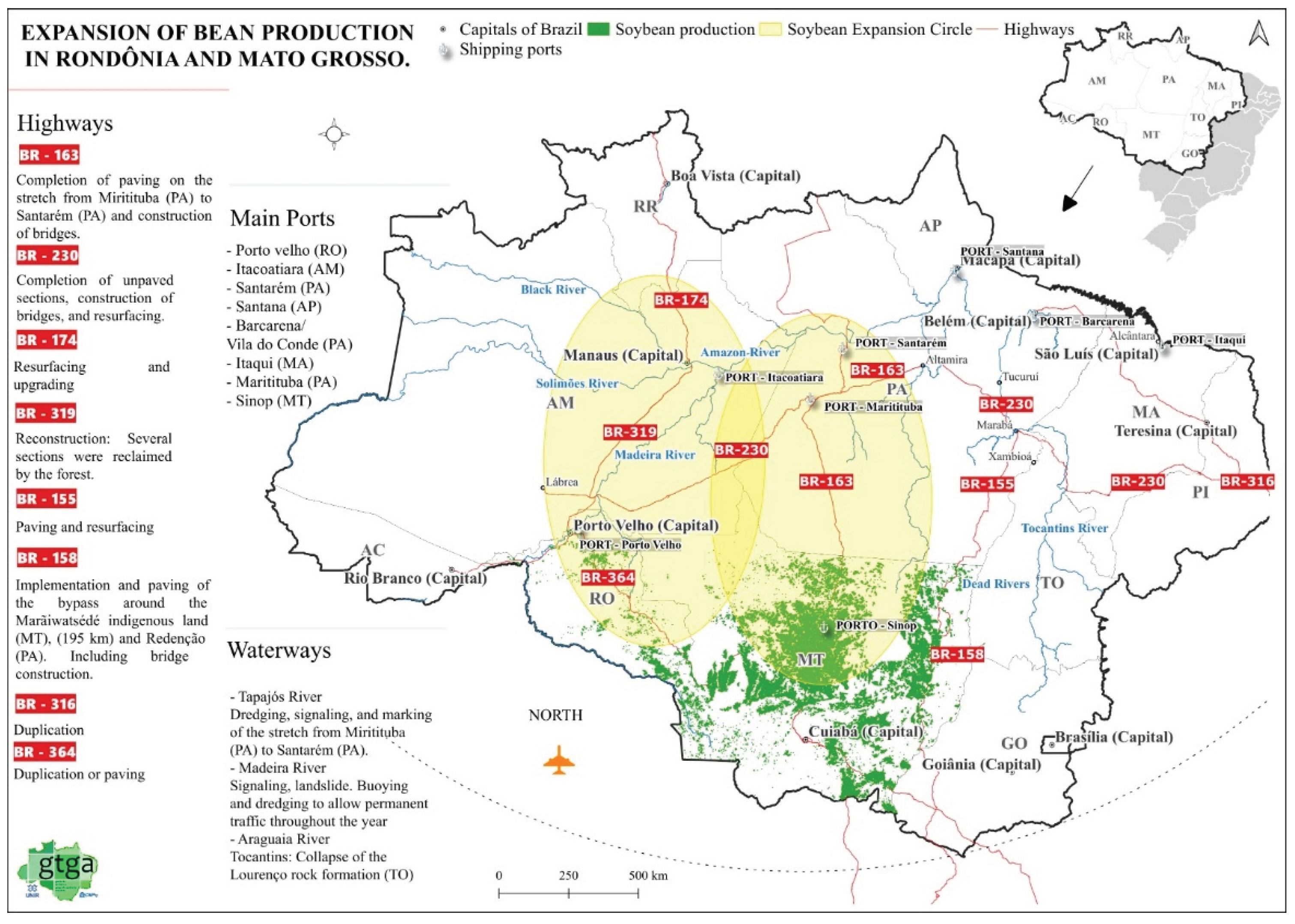
Figure 2.
Location of the Tanaru Indigenous Territory and rural settlements in the Corumbiara region (Rondônia).
Figure 2.
Location of the Tanaru Indigenous Territory and rural settlements in the Corumbiara region (Rondônia).
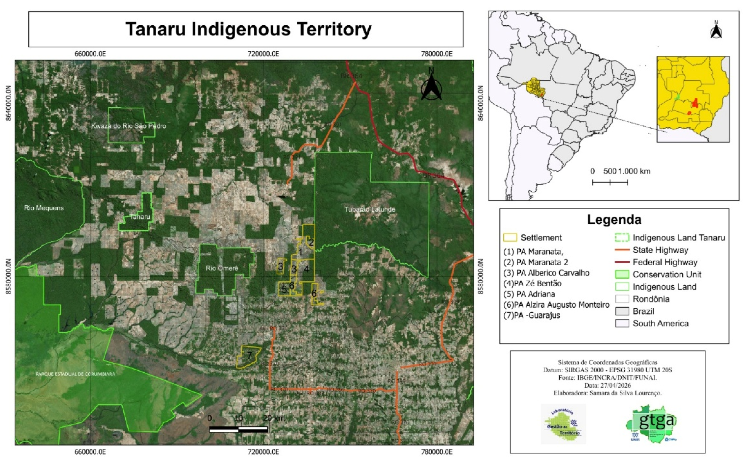

Table 1.
Data utilized in map production.
| Data Category | Source (Agency/Year) | Data utilized | Applied filters |
|---|---|---|---|
| Federation Unit | IBGE (2024) | National/state boundaries, Brazilian capitals | Emphasis on the North region |
| Official Highways | DNIT (2024) | Official highways of the North region | BR-364 (Acre–Cuiabá), BR-319, BR-174 (Boa Vista), BR-230, BR-163 (Sinop port connection), BR-163 (Altamira axis) |
| Ports and Major Rivers | ANA (2024) | Vessel ports and major Amazonian rivers | Ports: Porto Velho, Itacoatiara, Santarém, Santana, Barcarena, Itaqui, Miritituba, Sinop. Rivers: Tocantins, Das Mortes, Amazonas, Negro, Solimões, Madeira |
| Soybean data | CONAB (2024) | Soybean Data | Filtered specifically for Rondônia and Mato Grosso |
| Rural Settlements | INCRA (2024) | Federal rural settlements | Projects: Maranata, Maranata 2, Alberico Carvalho, Zé Bentão, Adriana, Alzira Augusto Monteiro, and Guarajus (Rondônia) |
| Indigenous territory | FUNAI (2025) | IT Data | Filtered for Rondônia: Kwazá do Rio Pedro, Tanaru, Rio Omerê, Rio Mequens, and Tubarão Latunde |
Source: The authors (2026). I organized these data into a geographic database and subsequently processed them using QGIS (version 3.34.11), which provides tools for visualization, editing, spatial analysis, and cartographic composition.
Disclaimer/Publisher’s Note: The statements, opinions and data contained in all publications are solely those of the individual author(s) and contributor(s) and not of MDPI and/or the editor(s). MDPI and/or the editor(s) disclaim responsibility for any injury to people or property resulting from any ideas, methods, instructions or products referred to in the content. |
© 2026 by the authors. Licensee MDPI, Basel, Switzerland. This article is an open access article distributed under the terms and conditions of the Creative Commons Attribution (CC BY) license (http://creativecommons.org/licenses/by/4.0/).
Copyright: This open access article is published under a Creative Commons CC BY 4.0 license, which permit the free download, distribution, and reuse, provided that the author and preprint are cited in any reuse.