

Submitted:
15 May 2026
Posted:
18 May 2026
You are already at the latest version
Abstract
The southern coast of Java, Indonesia, lies along the active Sunda subduction margin, where coastal landforms record the interaction between sea-level change, wave erosion, sedimentation, and tectonic uplift. Marine terraces and raised coastal surfaces are important geomorphic indicators of vertical deformation, but their interpretation remains difficult where chronological control is limited and where coastal surfaces have been modified by erosion, deposition, karstification, or human activity. This study presents new Real-Time Kinematic Global Navigation Satellite System (RTK-GNSS) topographic profiles from four coastal sites: Pantai Ajah, Kalijali, Kulon Progo, and Wingko. The profiles were measured from the beachward side toward the landward side and were used to identify terrace treads, risers, slope breaks, residual topographic highs, and possible raised coastal platforms. These field data are integrated with published information on Holocene sea-level change, marine terraces, coastal uplift, and forearc deformation along the southern Java margin. The RTK profiles show variable terrace morphology between sites. Pantai Ajah preserves a prominent riser and a probable terrace tread at approximately 7–8.5 m elevation. Kalijali records a lower terrace-like surface at approximately 4–5 m, an upper surface at approximately 7–9 m, and a higher local topographic high near 12–13 m. Kulon Progo shows a subdued low-elevation raised coastal surface, while Wingko contains a distinct slope break at approximately 1450–1500 m from the beachward end and a broad landward surface at approximately 5–6.5 m elevation. The profiles suggest two tentative morphostratigraphic terrace groups: a lower group at approximately 4–6.5 m and an upper group at approximately 7–9 m. Higher local peaks, including the 12–13 m high at Kalijali and comparable elevated points at other sites, may represent remnants of older or more strongly uplifted coastal features. One possible interpretation is that some of these higher surfaces originated near the mid-Holocene sea-level highstand, when relative sea level in parts of Indonesia and Sundaland was higher than present, and were subsequently uplifted to different elevations according to local uplift rates. However, this hypothesis requires direct chronological and sedimentological confirmation. The raised terrace ridges and topographic highs may also act as partial natural barriers that reduce tsunami flow penetration inland, although they should not be treated as complete protection. Overall, RTK profiling provides a useful field method for recognizing coastal terrace morphology and identifying priority sites for future dating, tsunami-inundation modelling, and coastal-hazard planning.
Keywords:
RTK‐GNSS
; Holocene highstand
; coastal uplift
; topographic profile
; tsunami mitigation
; neotectonics
; southern Java
; Sunda Arc
1. Introduction
The southern coast of Java is located along the active Sunda subduction margin, where the Indo-Australian Plate converges beneath the Eurasian or Sundaland plate. This tectonic setting produces earthquakes, tsunamis, vertical crustal deformation, and long-term coastal uplift. The coastal zone of southern Java is therefore an important area for studying the relationship between Quaternary sea-level change, active tectonics, coastal geomorphology, and natural-hazard mitigation [1,2]. This tectonic activity creates a broad range of persistent forearc uplift and transient coseismic effects, which sculpt geologic features throughout the ages [3,4]. As a result, the southern coastal region of Java has turned into a natural laboratory for the investigation of Quaternary tectonic events, paleoseismic activity, and coastal landform evolution.
Marine terraces are among the most useful landforms for reconstructing relative sea-level history and vertical land movement. They commonly form as wave-cut platforms, abrasion surfaces, beach deposits, or coastal benches during periods of relative sea-level stability. If these surfaces are later uplifted, they may be preserved above present sea level as terrace treads separated by risers or paleo-sea cliffs. In tectonically active margins, terrace morphology may record both long-term uplift and short-term coseismic deformation. However, terrace interpretation can be complicated by erosion, sediment cover, karst processes, fluvial modification, and anthropogenic disturbance.
One of the key contributions of this study of neotectonics along the continental margin is locating the source of the earthquake and tsunami risks for the highly populated southern coastal areas of Java. Geological records and historical accounts attest and corroborate the records of immense destructive waves associated with megathrust events along the boundary of the plates [5,6]. Along the Sunda subduction zone, the questions of fault segmentation, the uplift pattern development, and the recurrence timescale have all prompted scientific scrutiny, as the subduction zone is associated with significant uplift. Significant uncertainties remain regarding recurrence intervals, rupture segmentation, and the temporal evolution of uplift patterns along the Sunda subduction zone [7,8]. The geologists have had to resort to proxies to depict the modalities of the seismic cycle because contemporary instrumental seismic data do not fully suffic the inadequacies of the seismic cycle in representational terms.
The primary evidential indicators that have been reconstructed which shows the variation in sea level in conjunction with tectonic movements through time are the marine terraces [3,4]. Given the association of these features with Marine Isotope Stage (MIS), it is apparent that interseismic activity differs from coseismic activity resulting from megathrusts [9]. The combination of elevation with chronological data regarding these landforms assists in tracing the uplift rate from the glacial to Holocene [10].
Despite important advances in previous studies of marine terraces and neotectonic deformation along the southern coast of Jawa [11,12,13,14,15,16], several gaps remain. Most earlier works relied on regional geomorphological mapping, remote sensing, DEM-based interpretation, literature compilation, or broad geophysical synthesis, while direct field-based topographic measurements across individual terrace profiles are still limited. Consequently, the local morphology of terrace treads, risers, shoreline-angle zones, and residual coastal highs has not been sufficiently constrained, and terrace correlations between sites often remain tentative. In addition, many uplift interpretations depend on assumed correlations with Marine Isotope Stage or Holocene sea-level highstands, but direct chronological control is still sparse, making uplift-rate estimates provisional. Previous studies also have not always been able to clearly distinguish true marine terraces from fluvial, aeolian, karstic, erosional, or anthropogenically modified surfaces, particularly in low-elevation coastal settings. The Real-Time Kinematic Global Navigation Satellite System (RTK-GNSS) survey conducted in this study helps address these limitations by providing direct, high-resolution cross-shore elevation profiles from Pantai Ajah, Kalijali, Kulon Progo, and Wingko. These measurements allow terrace treads, slope breaks, possible risers, and higher topographic features to be identified more clearly, improve the basis for tentative terrace correlation, and provide new field evidence for evaluating differential uplift, coastal segmentation, and the possible role of raised coastal landforms as natural barriers for tsunami-risk reduction.
This study applies RTK-GNSS transect measurements to selected coastal sites along southern Java to investigate marine terrace morphology and its relationship to neotectonic processes. Specifically, this study (1) characterizes coastal profiles using high-resolution RTK-GNSS data, (2) identifies key geomorphic features including terrace treads, risers, slope breaks, and elevated residual surfaces, (3) establishes a preliminary morphostratigraphic correlation across four representative sites, and (4) evaluates the possible association of elevated coastal features with the mid-Holocene relative sea-level highstand and their potential role as partial natural barriers to tsunami inundation. By integrating RTK-GNSS measurements with geomorphological analysis of marine terraces, this study provides new field-based constraints on coastal uplift and forearc segmentation along southern Java. The results contribute to improving terrace interpretation at the local scale, refining the understanding of spatial variability in uplift patterns, and offering new insights into the role of coastal geomorphology in mitigating tsunami impacts within an active subduction margin.
2. Geological, Sea-Level and Geomorphological Background
2.1. Tectonic Setting of Southern Java
Southern Java forms part of the active Sunda Arc (Figure 1), where subduction-related deformation influences the morphology of the coastal margin. The interaction between plate convergence, forearc deformation, inherited crustal structures, and local geomorphic processes can produce spatially variable uplift and subsidence. This variability is important for interpreting marine terraces because terrace elevation is not controlled only by eustatic sea level, but also by vertical land motion.
Along active margins, the same original shoreline surface may be preserved at different elevations if different coastal blocks experience different uplift rates. Conversely, surfaces at similar elevations may not necessarily be the same age if uplift histories differ. Therefore, terrace correlation must be treated carefully, especially where independent age control is absent.
2.2. Holocene Sea-Level Highstand in Indonesia and Sundaland
A mid-Holocene relative sea-level highstand has been documented across several parts of Indonesia and the broader Sundaland. Multiple studies indicate that relative sea level during the mid-Holocene was higher than present, typically occurring around 6–7 ka BP, with reported magnitudes commonly in the range of approximately +2 to +3 m above present sea level in parts of the region [18,19,20]. For instance, studies from Java and adjacent areas of Sundaland have identified low-amplitude Holocene sea-level oscillations on the order of a few meters, although both the magnitude and timing of highstands show considerable spatial variability depending on local tectonic and isostatic conditions [21,22,23].
This regional context is particularly relevant for interpreting elevated coastal landforms. A shoreline or coastal platform originally formed during a highstand of approximately +2 to +3 m could presently occur at higher elevations if the coastline has experienced post-formational uplift. For example, a landform formed near +3 m at ~6 ka BP and subsequently uplifted by several meters could now be preserved at elevations of ~5–9 m or higher, depending on local uplift rates and tectonic setting. However, such interpretations remain provisional in the absence of independent chronological constraints and sedimentological validation.
Recent studies further demonstrate that mid-Holocene sea-level highstands are not spatially uniform across Indonesia, with some regions recording lower amplitudes or more complex relative sea-level histories influenced by local tectonics, sediment dynamics, and glacio-hydro-isostatic adjustments [24,25,26]. Consequently, the mid-Holocene highstand model should be considered as a plausible interpretative framework rather than a definitive age attribution for the RTK-GNSS-derived coastal surfaces.
2.3. Terrace Morphology and Tsunami Relevance
Raised coastal terraces, beach ridges, and topographic highs may influence tsunami inundation by acting as partial natural barriers. Natural coastal landforms such as dunes, beach ridges, reefs, mangroves, and coastal ridges can reduce wave energy, flow depth, or inland penetration under some conditions, although their effectiveness depends on height, width, continuity, vegetation cover, slope, tsunami size, and the presence of gaps or channels.
For this reason, the elevated terrace ridges and local highs identified in the RTK profiles are important not only for reconstructing coastal evolution, but also for coastal-hazard assessment. However, they should not be regarded as complete protection. A large tsunami can overtop, erode, breach, or flow around natural barriers. Therefore, such landforms are best understood as components of a broader multi-layered mitigation strategy that includes evacuation planning, hazard zoning, early warning, land-use regulation, and engineered or nature-based coastal protection.
3. Historical Background of Terrace Studies
In the last half century, the studies of geomorphological mapping, for the reconstruction of sea levels, and the seismology of the Sunda Arc, has evolved the studies of marine terraces along the southern coast of Java. The first detailed descriptions of raised coastal landforms as neotectonic indicators were made after reconnaissance expeditions of the early 1970s and 1980s. Like other early geologists, Untung and Wiriosudarmo [27] documented large, broad, and gently sloping coastal terraces that show in their layers the record of successive uplift episodes. The early studies documented the structural segmentation along the Java border and set the stage for the intercontinental tracing of the forearc’s long term deformations.
In the 1990s a new phase commenced, in which the morphology of marine terraces began to be successfully integrated with structural elements for geomorphological interpretation of the highest order. Tjia [28] documented coastal uplift in Java, and provided a basis for the explanation of discrepancies in the elevations of the terraces that pointed to the forearc region and the megathrust section of the activated zone. Shortly after, Urushibara-Yoshino and Yoshino [29] further characterized the landforms using improved remote sensing to differentiate marine, fluvial, and denudational units. Their work emphasized the value of the identified shoreline as the most important feature for determining the location of the former coastal line.
The start of the new millennium marked the sea level study advancements that enabled global comparability of the interpretation of terrace sequences. The integration of such morphological levels with Marine Isotope Stage (MIS) was made possible due to the combination of sophisticated radiometric (U-Th, ESR, OSL) dating, high-resolution paleowater-level curves, and studies of the Quaternary Period. Pedoja et al. [3] initiated a detailed synthesis work aiming to establish a comparative analysis across different tectonic settings from subduction and forearc to passive margin, and created the first comparative terrace chronology synthesis. The study demonstrated global contemporary terrace formation during high-tide interglacials and confirms the efficacy of the MIS-based methodology for studying uplift history.
Since the 2010s, SRTM, ASTER, and TanDEM-X digital models have been used for determining and improving the reliability of geomorphological analyses and interregional correlations of the terraces. In the 2006 Java Earthquake and Tsunami, paleoseismology rekindled the interest in the uplift history of South Java. This Significant Tectonic event brings to the fore the need to reconstruct the extensive gaps of earthquake recurrences to lessen the devastating impacts of such tectonic phenomena.
Advancements in methods have impacted how terrace studies are undertaken. For example, Komori et al. [30] employed a statistical clustering method to objectively classify terrace units, minimizing the role of human interpretation, and facilitating comparisons across different preservation conditions. These computational tools, together with the best coastline angle extraction methods and high-resolution topography like LiDAR and UAV photogrammetry, have improved terrace deformation analysis. The latest techniques guarantee that the morphological mapping is accurate to the scientific standards that are more dependable than the previous methodologies.
Xia et al. [31] describe a new technique to view regional uplift tectonic processes using seismic tomography, forearc structural imaging, and the megathrust locking model. Combining offshore observational data with onshore core records marks a shift from geomorphic to geodynamic interpretations. Cross-validation of the field information set reveals subduction zone interactions with these modern geophysical imaging devices. This combination method uses a lot of physical information from multiple spatial dimensions to improve crustal motion studies.
Since reconnaissance mapping was supplanted by geophysical geomorphology, southern Java terrace formation, megathrust uplift, and segmentation are better understood. These findings provide for mapping earthquake and tsunami dangers along this heavily populated border using data from several sources. Using measured and methodical analysis, these disciplines improve catastrophe risk identification. This scientific understanding reduces damage in tectonically fragile coastal areas.
Table 1 shows terrace elevations, shorelinea ngle measurements, and morphological attributes were compiled from previous works and integrated with more recent terrace correlation [3] and clustering approaches [30]. To ensure consistency across regions with varying data quality, these literature-based observations were supplemented by topographic analysis using multiple digital elevation models. DEMNAS served as the primary base dataset, supported by SRTM and TanDEM-X to refine shoreline-angle identification in areas where terrace morphology is subtle or degraded. Shore-normal topographic profiles were examined manually to delineate slope breaks and benches indicative of palaeo–sea-level positions, with curvature and slope analyses applied where geomorphic expressions were unclear. Chronological interpretation relied on independent dating where available, incorporating U–Th ages from coral platforms, OSL ages from terrace sediments, and ESR ages from carbonate deposits. In localities lacking direct age control, terrace–MIS correlations followed the conservative guidelines of Pedoja et al. [3]. Eustatic corrections were applied using the sea-level reconstruction of Waelbroeck et al. [32] allowing uplift rates to be estimated by adjusting terrace elevations for past global sea-level positions.
Based on previous studies, marine terraces between Pangandaran, Gunung Kidul, and Pacitan display stair-stepped geomorphology, typically comprising 2–4 levels. Elevation data combined with chronological control from coral and volcaniclastic units suggest uplift rates of approximately 0.1–0.4 mm yr⁻¹ in the west and up to 1.0 mm yr⁻¹ toward the east [11,12]. Quantitative methods for terrace identification and clustering [30] improve the robustness of inter-site comparisons. When terraces with independent ages are correlated to MIS highstands using Waelbroeck et al. [32], uplift estimates are broadly consistent with earlier regional syntheses, yielding rates of 0.1–1.0 mm yr⁻¹ across different blocks. These variations align with mapped horst–graben segments, implying systematic west–east gradients structural partitioning of uplift. Seismic and geophysical imaging [31] support a horst–graben segmentation that plausibly controls the observed spatial pattern.
The southern margin of Java displays a complex but coherent morphotectonic pattern of uplift (Figure 2), with rates that vary spatially between approximately 0.05 and 0.20 mm/yr over Quaternary timescales. Terraces and coastal notches documented at sites from Lebak in the west to Pacitan in the east record alternating phases of stability and uplift, corresponding to forearc segmentation along the Sunda subduction zone. In the Gunung Kidul–Gunung Sewu region, multiple levels of marine and fluvial terraces (at ~2, 6, 15–20, 40, and 80 m a.s.l.) suggest a long-term mean uplift of roughly 0.10–0.16 mm/yr, assuming MIS 5e (≈125 ka) terrace correlation. Deeper river terraces along the Oyo River (45–130 m a.s.l.) imply earlier Pleistocene surfaces, with local uplift exceeding 0.3 mm/yr if older ages are considered. These observations are consistent with the regional morphometric relief values (25–100 m coastal relief) reported by Haryono and Day [12], indicating sustained but moderate tectonic emergence of the Gunung Kidul block. Further east, the Pacitan–Klayar coastal segment preserves abrasion platforms and marine notches 1–2 m above modern high-tide levels [13], reflecting short-term uplift or coseismic deformation within the late Holocene. In contrast, the Lebak–Pangandaran area, where Putra et al. [15] identified paleotsunami deposits in nearshore stratigraphy, represents a relatively low-uplift section, likely characterized by interseismic subsidence punctuated by episodic coseismic uplift.
The spatial gradient of uplift rates inferred from terrace elevation suggests that the southern Java forearc is not uniformly uplifting, but segmented into structural blocks bounded by oblique-slip faults that accommodate variable coupling with the subducting Indo-Australian plate (Figure2). The Gunung Kidul–Pacitan sector appears to behave as a moderately uplifted morphotectonic high, possibly reflecting a locked subduction interface or crustal duplexing beneath the forearc basin. Conversely, the Lebak–Pangandaran sector may represent a transition zone toward lower coupling, consistent with the absence of extensive terrace staircases and the presence of low-lying coastal plains.
This pattern agrees with offshore seismic interpretations [31] showing forearc structural highs east of 110°E and flexural depressions toward the west. The combination of geomorphic and geophysical evidence thus supports a model of spatially heterogeneous uplift, modulated by both interplate coupling strength and inherited basement structures.
Integration of terrace elevation and coral or notch data suggests that the long-term (Pleistocene) uplift rate across southern Java averages ~0.1 mm/yr, whereas short-term (Holocene) uplift episodes may reach 1–2 m per event, as seen in Table 2, consistent with observed notches in Kázmér et al. [14] and microatoll benchmarks in other segments of the Sunda Arc. This multi-timescale uplift pattern highlights the importance of distinguishing steady tectonic uplift from episodic coseismic deformation, particularly when assessing long-term coastal stability and tsunami hazard potential.
The consistent west–east uplift pattern along the southern Java forearc is clear, but there are two major problems with using terrace-derived uplift rates: (1) the reported uplift values are averaged over time, and (2) we don’t know how terraces form in mixed gradual and coseismic uplift regimes. It is important to talk about these limits directly so that the data can be put in the right context within a solid Quaternary tectonic framework and not be overinterpreted. The uplift rates presented in this study span approximately two orders of magnitude (about 0.02–1.0 mm yr⁻¹), reflecting both regional variability and inherent differences in the temporal scales of uplift measurement.
Long-term uplift rates derived from Pleistocene marine terraces, typically linked to MIS 5e or earlier highstands, signify time-averaged vertical displacement over a minimum span of 100,000 years. These values include many earthquake cycles, periods of interseismic strain buildup, and times when tectonic activity is relatively low. This makes it impossible to directly compare them to short-term uplift measurements from Holocene coastal notches, coral microatolls, or historical seismic events. On the other hand, uplift magnitudes of 1–2 m inferred from late Holocene notches or karst formations signify individual or clustered coseismic events, and when expressed as rates (mm yr⁻¹), they may misleadingly imply ongoing uplift at those levels. These clear differences show that we need to separate mean Quaternary uplift, MISscale uplift, and event-scale coseismic displacement. If there isn’t this difference, the uplift gradients along the strike may seem too high or contradictory. The uplift rates given should be seen as scale-dependent indicators, not as measurements that can be directly compared. The long-term regional average of about 0.1 mm per year shows that the forearc is still rising, while higher apparent rates mostly show temporary changes that are superimposed on this baseline signal. Future research that integrates terrace chronologies with continuous geodetic data will be essential for assessing whether current vertical deformation indicates Quaternary trends or represents a temporary phase in the seismic cycle. Uncertainty in terrace formation amidst diverse uplift conditions.
A second limitation concerns the process of marine terrace formation in southern Java, where both gradual interseismic uplift and abrupt coseismic displacement are believed to contribute to terrace development. Classical terrace models suggest that formation transpires during eustatic highstands characterized by continuous uplift, subsequently succeeded by abandonment amid sea-level decline. In active subduction zones such as Java, terraces can develop through rapid coseismic uplift, repeated coastal reoccupation, and wave planation following emergence. In these situations, a single geomorphic surface may record multiple deformation events rather than a specific sea-level stillstand, thereby complicating associations with certain Marine Isotope Stages. Terrace clustering techniques reduce personal bias in figuring out terrace levels, but they don’t make it clear if the grouped surfaces are the result of a single event of uplift, cumulative deformation from many earthquakes, or reworked surfaces that have been partially reset by erosion. This uncertainty is particularly relevant for low-elevation terraces and notches, which may be influenced by Holocene sea-level fluctuations. Consequently, terrace–MIS connections lacking independent age control should be regarded as conjectures rather than definitive chronostratigraphic conclusions. To discuss the difference between gradual and episodic uplift models, we need better chronological constraints, like U–Th dating of corals, OSL dating of beach and dune deposits, and radiocarbon dating of related sediments. To tell the difference between wave-cut platforms and surfaces that have been changed by rivers or karst, we will need high-resolution topographic data along with stratigraphic and sedimentologic study. Understanding these limits doesn’t make the uplift gradients or forearc segmentation any less important; it merely clarifies their implications.
Integration of terrace elevation and coral or notch data suggests that the long-term (Pleistocene) uplift rate across southern Java averages ~0.1 mm/yr, whereas short-term (Holocene) uplift episodes may reach 1–2 m per event, as seen in Table 2, consistent with observed notches in Kázmér et al. [14] and microatoll benchmarks in other segments of the Sunda Arc. This multi-timescale uplift pattern highlights the importance of distinguishing steady tectonic uplift from episodic coseismic deformation, particularly when assessing long-term coastal stability and tsunami hazard potential.
4. Materials and Methods
4.1. Field Survey and Data Acquisition
This study is designed as a field-based geomorphological survey supported by regional literature synthesis. The primary dataset consists of RTK-GNSS topographic profiles measured across four coastal sites: Pantai Ajah, Kalijali, Kulon Progo, and Wingko (Figure 3). These profiles provide high-resolution cross-shore elevation data that are used to identify terrace morphology and possible raised coastal surfaces.
4.2. RTK-GNSS Topographic Profiles
RTK-GNSS profiles were measured from the beachward side toward the landward side (Figure 3). In the profile figures, point A represents the beachward end of each transect and point B represents the landward end. This orientation allows the profiles to capture the transition from modern coastal surfaces to older or higher landward geomorphic features.
The profiles were interpreted by identifying:
- Broad and gently sloping surfaces that may represent terrace treads;
- Steep slope breaks that may represent terrace risers or paleo-sea cliffs;
- Shoreline-angle zones marking transitions between former platforms and scarps;
- Isolated topographic highs that may represent residual ridges, bedrock highs, dunes, erosional remnants, or locally uplifted former shoreline features.
The terrace interpretation emphasizes surface continuity rather than isolated elevation peaks. A broad surface is more reliable as a terrace tread than a narrow peak, because marine terrace treads are usually laterally continuous geomorphic surfaces.
4.3. Criteria for Terrace Interpretation
A landform was interpreted as a probable terrace tread when it showed a broad or semi-continuous profile expression, a relatively low gradient, and separation from adjacent surfaces by a clear slope break. A steep change in elevation was interpreted as a possible riser, scarp, or paleo-sea-cliff zone. Narrow peaks were interpreted cautiously because they may reflect local relief rather than true terrace surfaces.
The RTK profiles provide strong morphological information, but they do not provide ages. Therefore, all terrace correlations in this study are morphostratigraphic and preliminary. Confirmation requires geochronological dating, sedimentological logging, and field verification of marine indicators such as beach deposits, abrasion surfaces, marine shells, coral fragments, beachrock, or coastal sedimentary structures.
4.4. Integration with Holocene Sea-Level Context
The profile interpretations are also considered in relation to the possible mid-Holocene highstand. If relative sea level was around 2–3 m above present in parts of the Indonesian region during the mid-Holocene, then some raised coastal surfaces now located above that elevation may reflect the combined effect of highstand formation and subsequent uplift.
For example, a surface formed near +3 m at approximately 6000 BP could now appear at 6 m if uplift of about 3 m occurred after formation. Similarly, it could now occur near 9 m or 12 m if uplift was greater or if the surface represents an older or locally higher shoreline feature. This logic provides a possible explanation for why similar coastal features may occur at different elevations between locations. However, this remains a hypothesis that must be tested by dating and sedimentology.
5. Results
The RTK profiles show that coastal terrace morphology is variable across the four study sites. The profiles do not define one continuous terrace level along the entire coast. Instead, each location shows a different combination of low surfaces, higher treads, slope breaks, and local topographic highs.
Pantai Ajah and Kalijali show the clearest stepped morphology. Wingko also contains a probable raised landward surface, while Kulon Progo shows a weaker and more subdued terrace signal. Overall, the probable terrace surfaces occur mainly between approximately 4 m and 9 m elevation, while higher local peaks reach approximately 12–14 m at some locations.
These higher points are important because they may preserve remnants of older or more strongly uplifted coastal features. They may also have practical importance because they form elevated zones that could reduce tsunami flow penetration inland, especially where they are continuous and not dissected by channels.
5.1. Pantai Ajah
The Pantai Ajah profile shows one of the clearest stepped morphologies in the dataset. A major slope break occurs at approximately 650–750 m from the beachward end of the profile, where the elevation rises sharply from around 2 m to more than 10 m. Landward of this steep slope, the profile forms a broader surface at approximately 7–8.5 m elevation (Figure 4).
This broad surface is interpreted as the main probable terrace tread at Pantai Ajah. The steep slope below it is interpreted as a terrace riser or degraded paleo-sea cliff. A higher local peak reaches approximately 13–14 m, but this feature is narrow and should not automatically be treated as the main terrace tread. It may represent a local ridge, erosional remnant, bedrock high, dune ridge, or a more strongly uplifted fragment of an older coastal surface.
The Pantai Ajah profile therefore records both a probable main terrace surface and a higher residual topographic feature. The main terrace surface is most suitable for correlation, while the higher peak should be treated as a possible remnant requiring further field verification.
5.2. Kalijali
The Kalijali profile shows complex stepped morphology and is especially important because it contains both low terrace-like surfaces and a higher topographic high. The lower surface occurs at approximately 4–5 m elevation and forms a relatively broad landward segment. An upper surface occurs at approximately 7–9 m elevation and is separated from the lower level by a slope break. In addition, the profile includes a higher point at approximately 12–13 m (Figure 5). The lower 4–5 m surface is interpreted as a probable lower terrace or raised coastal platform. The 7–9 m surface is interpreted as an upper terrace-like level. The higher 12–13 m point may represent a residual high, a ridge, or a remnant of an older or more strongly uplifted coastal landform.
One possible interpretation is that the 12–13 m high at Kalijali and comparable elevated points at other sites are related to coastal features formed during or near the mid-Holocene highstand, when relative sea level in parts of Indonesia and Sundaland may have been higher than present. If the original shoreline or coastal platform formed near +3 m and was subsequently uplifted, different uplift amounts could explain why the same general type of feature now occurs at different elevations between sites. This interpretation is plausible but not proven. It requires direct dating of the surface or associated sediment and confirmation that the feature is marine in origin. The Kalijali profile is therefore interpreted as recording at least two terrace-like levels and one higher residual feature. This makes Kalijali one of the most important sites for future sampling because it may preserve multiple stages of coastal emergence.
5.3. Kulon Progo
The Kulon Progo profile shows a weaker terrace expression than Pantai Ajah and Kalijali. The profile is more subdued and does not display a sharply defined staircase morphology. A low, gently sloping surface at approximately 4–5 m elevation may represent a raised coastal surface, but the interpretation is tentative (Figure 6).
The subdued form may reflect weaker uplift, stronger erosion, greater sediment cover, or modification by coastal and human processes. Alternatively, the surface may not be marine in origin. For this reason, Kulon Progo should be treated as a low-confidence terrace site until field evidence confirms the presence of marine deposits or abrasion features. If the low surface is marine, it may correlate with the lower terrace group recognized at Kalijali and Wingko. However, without age control, this correlation remains preliminary.
5.4. Wingko
The Wingko profile consists of an irregular beachward and central sector followed by a more continuous landward surface. From the beachward end to approximately 1450 m, the profile contains short-wavelength undulations and narrow local highs. A distinct slope break occurs at approximately 1450–1500 m, where elevation rises from around 3 m to more than 5 m. Landward of this break, the profile forms a broad surface at approximately 5–6.5 m elevation.
This landward surface is interpreted as a probable terrace tread or raised coastal platform (Figure 7). The break at approximately 1450–1500 m is interpreted as a possible terrace riser, scarp, or shoreline-angle zone. The irregular lower sector may represent coastal reworking, sedimentary modification, or a lower surface that has been dissected or disturbed. The Wingko profile is important because it provides an intermediate-elevation surface between the lower 4–5 m surfaces and the upper 7–9 m surfaces. It may therefore represent either a slightly uplifted equivalent of the lower terrace group or a separate intermediate level.
6. Discussion
6.1. Correlation of Terrace Surfaces Between Sites
Based on the RTK-GNSS profiles, the coastal morphology can be broadly organized into two principal terrace groups, accompanied by a set of higher, discontinuous coastal elevations. This classification is derived from consistent patterns in elevation, surface continuity, and overall profile morphology observed across the four study sites. Although the absence of direct chronological control introduces uncertainty, this subdivision provides a useful working framework for comparing geomorphic features and exploring tentative morphostratigraphic relationships. The identified groups likely reflect differences in formation age, preservation state, and the influence of spatially variable uplift processes along the southern Java margin.
6.1.1. Lower Terrace Group (Approximately 4–6.5 m)
The lower terrace group includes the lower surface at Kalijali, the tentative low surface at Kulon Progo, and the landward surface at Wingko. Kalijali and Kulon Progo occur mainly around 4–5 m elevation, while Wingko occurs slightly higher, around 5–6.5 m. This group is interpreted as representing a relatively younger raised coastal surface, or a set of closely related surfaces formed during late Holocene to mid-Holocene sea-level conditions. Subsequent modification by local uplift, erosion, and sedimentary processes may have contributed to the observed variability in elevation. The slightly higher position of the Wingko surface may reflect stronger localized uplift, better geomorphic preservation, or correlation with a marginally older surface within the same depositional framework.
6.1.2. Upper Terrace Group (Approximately 7–9 m)
The upper terrace group is best expressed at Pantai Ajah and in the upper surface at Kalijali, where both sites display comparable elevation ranges and well-defined stepped morphology. This represents the most consistent morphostratigraphic correlation identified in the dataset. These surfaces may correspond to an older or more strongly uplifted coastal level relative to the lower terrace group. One plausible interpretation is that they formed during a mid-Holocene relative sea-level highstand and were subsequently uplifted to their present elevations. Assuming an initial shoreline position near +3 m, current elevations of 7–9 m would imply post-formational uplift on the order of ~4–6 m. While such values are relatively high for a ~6000-year BP, they may be locally feasible in tectonically active settings characterized by episodic, coseismic uplift or deformation concentrated along forearc structures. However, this interpretation remains tentative and requires validation through independent chronological and sedimentological evidence.
6.1.3. Higher Local Highs (Approximately 12–14 m)
In addition to the two main terrace groups, several higher and more localized topographic features are observed, particularly at Kalijali (~12–13 m) and Pantai Ajah (~13–14 m). Unlike the lower and upper terrace groups, these features are narrower and lack clear lateral continuity, and are therefore not interpreted as regionally developed terrace treads.
Nevertheless, these elevated features are geomorphologically significant and warrant further consideration. They may represent (i) residual remnants of older terrace surfaces, (ii) uplifted beach-ridge or dune-ridge systems, (iii) bedrock or karstic highs modified by marine processes, (iv) erosional remnants of previously more extensive surfaces, or (v) locally uplifted features associated with Holocene or older sea-level positions.
A working hypothesis is that some of these elevations may have originated during the mid-Holocene sea-level highstand and were subsequently uplifted to different heights by spatially variable tectonic processes. If the highstand occurred at approximately +3 m around 6000 BP, present elevations of 12–13 m would imply substantial post-formational uplift or, alternatively, a significantly older origin. Given the implications of this interpretation, these features should be treated cautiously and require verification through direct dating and detailed field analysis. Accordingly, they are best described as candidate elevated coastal remnants rather than confirmed marine terraces.
6.2. Holocene Highstand, Differential Uplift, and Tsunami-Mitigation Significance
6.2.1. Possible Relationship to the Mid-Holocene Highstand
The mid-Holocene highstand provides a useful framework for interpreting low to moderate raised coastal surfaces along southern Java. Regional sea-level studies from Indonesia and Sundaland indicate that relative sea level was higher than present during parts of the mid-Holocene, although the magnitude and timing varied between locations [18,19,20,24,25,26]. Some records suggest highstands of around 2–3 m above present sea level between roughly 7000 and 4000 BP [18,19,20]. If coastal platforms, beach ridges, or abrasion surfaces formed during this period, they could now be preserved at higher elevations if the coast has been uplifted since formation [3,10]. This is particularly relevant for the 4–6.5 m lower terrace group and possibly for the 7–9 m upper group. The 12–14 m local highs may also be related to this framework, but their elevation would require either stronger uplift, episodic coseismic uplift, or an older origin [14]. Thus, the Holocene-highstand interpretation provides a plausible but unconfirmed explanation for the observed elevation differences. It is especially useful as a hypothesis for future testing.
6.2.2. Differential Uplift as an Explanation for Variable Elevations
The variation in terrace elevation between the four sites may reflect spatially variable uplift along the southern Java forearc [31]. If similar coastal surfaces formed at approximately the same relative sea level, then differences in their present elevation may indicate different uplift histories. For example, a surface formed near +3 m during the mid-Holocene could now occur at:
- ~4–5 m where uplift was small;
- ~5–6.5 m where uplift was moderate;
- ~7–9 m where uplift was stronger;
- ~12–14 m where uplift was very strong, episodic, or where the feature is older.
However, this model assumes that the surfaces are the same age and marine in origin, which has not yet been proven. The observed elevation differences may also reflect local erosion, sediment cover, lithology, dune formation, anthropogenic modification, or preservation bias. Therefore, the profiles support the idea of spatial variability in terrace elevation and preservation, but they do not yet allow definitive calculation of uplift rates [3,30]. Table 3 below showing the morphostratigraphic correlation between each location.
Elevations are interpreted from RTK topographic profiles and should be regarded as preliminary geomorphic estimates. Correlation is based on elevation range, profile morphology, surface continuity, and slope-break expression. Because no direct age control is currently available, the proposed correlation is morphostratigraphic rather than chronostratigraphic. Higher local peaks at Pantai Ajah and Kalijali are not treated as confirmed regional terrace treads, but they may represent residual coastal highs, older terrace remnants, or locally uplifted shoreline-related features that require further dating and sedimentological verification.
6.2.3. Higher Coastal Ridges as Natural Tsunami Barriers
The raised terrace surfaces and local topographic highs may have practical importance for tsunami mitigation [5,6]. A continuous ridge, terrace scarp, or elevated coastal platform can act as a partial barrier to incoming tsunami flow by increasing flow resistance, reducing inland penetration, or forcing water to concentrate through lower gaps and channels [5,6]. Studies of tsunami impacts have shown that coastal landforms such as dunes and beach ridges can reduce inland tsunami penetration under some conditions, particularly where tsunami heights are moderate and the barriers are continuous.
In this context, the 12–13 m high at Kalijali and other elevated points may function as natural topographic protection zones. The 7–9 m upper terrace surfaces at Pantai Ajah and Kalijali may also reduce direct inland flow where they form continuous ridges or scarps. The lower 4–6.5 m surfaces may provide more limited protection, but they can still influence tsunami flow paths by creating roughness, elevation contrasts, and local ponding zones.
However, these natural features should not be interpreted as complete tsunami defenses. Their protective function depends on height relative to tsunami run-up, width and continuity of the ridge or terrace, presence of low gaps, river mouths, roads, or drainage channels, surface roughness and vegetation, tsunami wave height, period, and direction, erosion or breaching during the event [5,6].
6.2.4. Implications for Land-Use and Hazard Planning
The RTK profiles can help identify areas where natural elevation may reduce tsunami exposure [5,6]. Higher terrace surfaces and ridges may be suitable as evacuation routes, temporary refuge zones, or priority areas for vertical-evacuation planning, provided that access is rapid and the surfaces are continuous. Low-lying areas seaward of the terrace risers are likely to be more exposed to inundation and should be prioritized for hazard zoning.
6.3. Knowledge Gaps and Future Work
Despite the insights gained from this study, several key uncertainties remain and highlight important directions for future research. A primary limitation concerns the lack of chronological control on the identified terrace surfaces. Without direct age constraints, it remains unclear whether these features are associated with the mid-Holocene sea-level highstand, earlier Holocene events, Marine Isotope Stage (MIS) 5e, or other Quaternary highstands [3,10]. Establishing reliable ages is therefore essential for resolving the temporal framework of coastal uplift and terrace development.
In addition to chronological uncertainty, the geomorphic origin of several surfaces requires further verification. This issue is particularly relevant for the Kulon Progo site and for the higher elevations in the 12–14 m range, where the observed landforms may represent a range of possible origins, including marine terraces, aeolian ridges, erosional remnants, karstic features, or anthropogenically modified surfaces [3,30]. Distinguishing between these possibilities is critical for accurate morphostratigraphic interpretation.
Another important limitation relates to the inferred role of elevated coastal features in tsunami mitigation. While RTK-GNSS transects provide high-resolution elevation data, the effectiveness of these features as natural barriers depends not only on their height, but also on their three-dimensional continuity, surface roughness, and interaction with tsunami hydrodynamics. As such, evaluating their protective function requires integration with numerical tsunami inundation modelling [5,6].
Addressing these uncertainties will require a combination of chronological, sedimentological, geomorphological, and modelling approaches. Future work should include Optically Stimulated Luminescence (OSL) dating of sandy terrace or beach-ridge deposits, as well as radiocarbon dating of shells, peat, or other organic materials where available [3,10]. Where suitable carbonate material is present, U–Th dating may provide additional constraints on terrace formation. Detailed sedimentological logging will be necessary to confirm the marine origin of suspected terrace deposits. High-resolution topographic mapping using UAV photogrammetry or LiDAR should be undertaken to trace terrace continuity and refine morphostratigraphic correlations across sites [30,31]. Furthermore, tsunami inundation modelling based on RTK-derived profiles and regional digital elevation models (DEMs) will be essential for assessing the hydrodynamic significance of coastal landforms [5,6]. Finally, integration with geodetic datasets, including GPS and InSAR, will provide valuable constraints on present-day uplift and subsidence patterns, enabling a more comprehensive understanding of active neotectonic processes along the southern Java margin [31,32]. Based on the RTK-GNSS profiles, the coastal morphology can be broadly organized into two principal terrace groups, accompanied by a set of higher, discontinuous coastal elevations. This classification is derived from consistent patterns in elevation, surface continuity, and overall profile morphology observed across the four study sites. Although the absence of direct chronological control introduces uncertainty, this subdivision provides a useful working framework for comparing geomorphic features and exploring tentative morphostratigraphic relationships. The identified groups likely reflect differences in formation age, preservation state, and the influence of spatially variable uplift processes along the southern Java margin [3,30].
7. Conclusions
This study presents new RTK-GNSS topographic profiles from Pantai Ajah, Kalijali, Kulon Progo, and Wingko along the southern coast of Java. The addition of these field measurements changes the manuscript from a review-style synthesis into a field-based geomorphological survey supported by published regional data. The RTK profiles identify several probable raised coastal surfaces. Pantai Ajah contains a prominent riser and a probable terrace tread at approximately 7–8.5 m elevation. Kalijali contains a lower surface at approximately 4–5 m, an upper surface at approximately 7–9 m, and a higher local topographic high at approximately 12–13 m. Kulon Progo shows a tentative low raised surface at approximately 4–5 m. Wingko contains a clear slope break at approximately 1450–1500 m and a probable terrace tread at approximately 5–6.5 m elevation. A tentative morphostratigraphic correlation suggests two main terrace groups: a lower group at approximately 4–6.5 m and an upper group at approximately 7–9 m. Higher local peaks at approximately 12–14 m may represent residual coastal remnants, older terrace fragments, dune or ridge features, or locally uplifted shoreline-related landforms. A possible hypothesis is that some of these features were originally associated with the mid-Holocene relative sea-level highstand, when sea level in parts of Indonesia and Sundaland was higher than present, and were subsequently uplifted to different elevations. However, this interpretation remains preliminary and requires direct dating and sedimentological confirmation. The raised terrace surfaces and topographic highs may also have practical importance as partial natural barriers to tsunami inundation. Where continuous and sufficiently high, these features may reduce inland tsunami penetration or influence flow pathways. Nevertheless, they should not be treated as complete protection, because large tsunamis may overtop, breach, or flow around natural barriers. Overall, the RTK profiles provide new field evidence for spatially variable terrace morphology along the southern Java coast. They support the interpretation of a complex coastal margin influenced by sea-level change, local geomorphic modification, and possible neotectonic segmentation. The most important next step is to date the identified surfaces and test whether their elevations reflect Holocene highstand formation, differential uplift, or older Quaternary terrace development.
Author Contributions
Conceptualization, E.Y, P.S.P., S.H.N. and A.M.R.; methodology, E.Y, P.S.P., S.H.N. and A.M.R.; software, P.S.P., S.H.N., A.M.R., P.A.I, Y.C and E.H..; validation, E.Y, P.S.P., S.H.N. and A.M.R.; formal analysis, E.Y, P.S.P., S.H.N. and A.M.R.; investigation, E.Y, P.S.P., S.H.N. and A.M.R.; resources, E.Y, P.S.P., S.H.N.; data curation, E.Y, P.S.P., S.H.N. and A.M.R.; writing—original draft preparation, E.Y, P.S.P., S.H.N., A.M.R; writing—review and editing, E.Y, P.S.P., S.H.N. and A.M.R.; visualization, E.H., P.A.I. and Y.C.; supervision, E.Y, P.S.P.; project administration, P.S.P. and S.H.N.; funding acquisition, P.S.P. All authors have read and agreed to the published version of the manuscript.
Funding
The research was funded by the Endowment Fund for Education Agency (LPDP) through the Strategic Invitation Research and Innovation for Advanced Indonesia program, Batch 2 for FY 2024–2025 (Award number: AWARD/B1-RIIM-AWARD/18520/1/2024).
Data Availability Statement
Further inquiries can be directed to the corresponding author.
Acknowledgments
We express our gratitude to the National Research and Innovation Agency (BRIN) for its support in securing research funding from the Endowment Fund for Education Agency (LPDP).
Conflicts of Interest
The authors declare no conflicts of interest.
Abbreviations
The following abbreviations are used in this manuscript:
| RTK | Real-Time Kinematic |
| GNSS | Global Navigation Satellite System |
| BP | Before Present |
| MIS | Marine Isotope Stage |
| OSL | Optically Stimulated Luminescence |
| SRTM | Shuttle Radar Topography Mission |
| ASTER | Advanced Spaceborne Thermal Emission and Reflection Radiometer |
| LiDar | Linear dichroism |
| UAV | Unmanned Aerial Vehicle |
| DEM | Digital Elevation Model |
| DEMNAS | Digital Elevation Model Nasional (Indonesia National DEM) |
| GPS | Global Positioning System |
| InSAR | Interferometric Synthetic Aperture Radar |
| OSL | Optically Stimulated Luminescence |
References
- Hamilton, W.B. Tectonics of the Indonesian Region; U.S. Geological Survey Professional Paper 1078: Washington, DC, USA, 1979; 345 p.
- Hall, R. Late Jurassic–Cenozoic reconstructions of the Indonesian region and the Indian Ocean. Tectonophysics 2012, 570–571, 1–41. [CrossRef]
- Pedoja, K.; Husson, L.; Johnson, M.E.; Melnick, D.; Witt, C.; Pochat, S.; Nexer, M.; Authemayou, C.; Delcaillau, B.; Pinegina, T.; Poprawski, Y.; Authemayou, C.; Elliot, M., Regard, V.; Garestier, F. Coastal staircase sequences reflecting sea-level oscillations and tectonic uplift during the Quaternary and Neogene. Earth-Sci. Rev. 2014, 132, 13–38. [CrossRef]
- Lajoie, K.R. Coastal tectonics. In Active Tectonics; Wallace, R.E., Ed.; National Academy Press: Washington, DC, USA, 1986; pp. 95–124.
- Sieh, K.; Natawidjaja, D.; Meltzner, A.; Shen, C.C.; Cheng, H.; Edwards, R.L.; Li, K.S.; Suwargadi, B.W.; Galetzka, J.; Philibosian, B.; Edwards, R.L. Earthquake supercycles inferred from sea-level changes recorded in corals. Nature 2008, 454, 1022–1026.
- Griffin, J.D.; Pranantyo, I.R.; Kongko, W.; Haunan, A.; Robiana, R.; Miller, V.; Davies, G.; Horspool, N.; Maemunah, I.; Widjaja, W.B.; Natawidjaja, D.H.; Latief, H. Assessing tsunami hazard using heterogeneous slip models in the Mentawai Islands, Indonesia. In Geohazards in Indonesia: Earth Science for Disaster Risk Reduction; P. R. Cummins, I. Meilano, Eds.; Geological Society, London, Special Publications: London, UK, 2017; Volume 441, Issue 1, pp. 47–70. [CrossRef]
- Natawidjaja, D.H.; Sieh, K.; Chlieh, M.; Galetzka, J.; Suwargadi, B.W.; Cheng, H.; Edwards, R.L.; Avouac, J.-P.; Ward, S.N. Source parameters of the great Sumatran megathrust earthquakes of 1797 and 1833 inferred from coral microatolls. J. Geophys. Res. 2006, 111, B06403. [CrossRef]
- Wang, K.; Hu, Y.; He, J. Deformation cycles of subduction earthquakes in a viscoelastic Earth. Nature. 2012, 484, 327-332. [CrossRef]
- Matsumoto, H.; Dickson, M.E.; Kench, P.S. Preservation and destruction of Holocene marine terraces: The effects of episodic versus gradual relative sea level change. Geophys. Res. Lett. 2021, 48, e2021GL094543. [CrossRef]
- Muhs, D.R.; Groves, L.T.; Schumann, R.R. Interpreting the paleozoogeography and sea level history of thermally anomalous marine terrace faunas: A case study from the last interglacial complex of San Clemente Island, California. Monogr. West. N. Am. Nat. 2014, 7(1), 82–108. [CrossRef]
- Andreini, J.; Bunds, M.P.; Harris, R.A.; Yulianto, E.; Horns, D.M.; Prasetyadi, C.; Putra, P.S. Assessment of differential uplift along South Java, Indonesia from terrace elevations mapped with Structure from Motion photogrammetry. In Proceedings of the American Geophysical Union Fall Meeting 2016, San Francisco, CA, USA, 12–16 December 2016; Abstract #EP21D-0911.
- Haryono, E.; Day, M. Landform differentiation within the Gunung Kidul Kegelkarst, Java, Indonesia. J. Cave Karst Stud. 2004, 66(2), 62–69.
- Tjia, H.D. Morphostructural development of Gunungsewu karst, Java Island. Indones. J. Geosci. 2013, 8(2), 75–88. [CrossRef]
- Kázmér, M.; Nahar, R.; Gaidzik, K. Late Holocene seismic uplift events depicted by coastal karst formations in Bali, Indonesia. Quat. Int. 2024, 712, 109577. [CrossRef]
- Putra, P.S.; Yulianto, E.; Praptisih, P.; Supriatna, N.; Trisuksmono, D.; Amar, A.; Nurhidayati, A.U.; Ridwan, J.; Griffin, J. Studi paleotsunami di selatan Jawa (in Indonesian). In Prosiding Pemaparan Hasil Penelitian Puslit Geoteknologi LIPI Tahun 2015: Meningkatkan Kualitas dan Diseminasi Hasil Penelitian Melalui Pemberdayaan Kerjasama Ilmiah; Harjono, H.; Delinom, R.M.; Hantoro, W.S.; Djuwansah, M.R.; Sumarnadi, E.T.; Sudaryanto; Indarto, S.; Soebowo, E.; Permana, H.; Handayani, L.; Tohari, A.; Cahyarini, S.Y.; Lubis, R.F.; Marganingrum, D.; Solihin; Hananto, N.D.; Mukti, M.M.; Yuniati, M.D., Eds.; Pusat Penelitian Geoteknologi, Lembaga Ilmu Pengetahuan Indonesia: Bandung, Indonesia, 2015; pp. 95–102.
- van Gorsel, J.T. Bibliography of the Geology of Indonesia—III: Java, Madura, Java Sea; 3rd ed.; 2011; pp. 576–862.
- Katili, J.A. Volcanism and plate tectonics in the Indonesian island arcs. Tectonophysics 1975, 26(3–4), 165–188. [CrossRef]
- Hanebuth, T.; Stattegger, K.; Grootes, P.M. Rapid flooding of the Sunda Shelf: A late-glacial sea-level record. Science 2000, 288(5468), 1033–1035. [CrossRef]
- Horton, B.P.; Gibbard, P.L.; Mine, G.M.; Morley, R.J.; Purintavaragul, C.; Stargardt, J.M. Holocene sea levels and palaeoenvironments, Malay–Thai Peninsula, Southeast Asia. Holocene 2005, 15(8), 1199–1213. [CrossRef]
- Woodroffe, S.A.; Horton, B.P. Holocene sea-level changes in the Indo-Pacific. J. Asian Earth Sci. 2005, 25(1), 29–43. [CrossRef]
- Bird, M.; Fifield, L.K.; Teh, T.S.; Chang, C.H.; Shirlaw, N.; Lambeck, K. An inflection in the rate of early mid-Holocene eustatic sea-level rise: A new sea-level curve from Singapore. Estuar. Coast. Shelf Sci. 2007, 71, 523–536. [CrossRef]
- Geyh, M.A.; Streif, H.; Kudrass, H.R. Sea-level changes during the late Pleistocene and Holocene in the Strait of Malacca. Nature 1979, 278(5703), 441–443. [CrossRef]
- Woodroffe, C.D. Late Quaternary sea-level highstands in the central and eastern Indian Ocean: A review. Glob. Planet. Change 2005, 49(1–2), 121–138. [CrossRef]
- Bradley, S.L.; Milne, G.A.; Horton, B.P.; Zong, Y. Modelling sea level data from China and Malay–Thailand to estimate Holocene ice-volume equivalent sea level change. Quat. Sci. Rev. 2016, 137, 54–68. [CrossRef]
- Lewis, S.E.; Sloss, C.R.; Murray-Wallace, C.V.; Woodroffe, C.D.; Smithers, S.G. Post-glacial sea-level changes around the Australian margin: A review. Quat. Sci. Rev. 2013, 74, 115–138. [CrossRef]
- Woodroffe, S.A.; Horton, B.P. Holocene sea-level changes in the Indo-Pacific. J. Asian Earth Sci. 2005, 25(1), 29–43. [CrossRef]
- Untung, M.; Wiriosudarmo, G. The structural pattern of Java and Madura based on the preliminary interpretation of the gravity. Tech. Publ. Geophys. Ser. 1975, 2(1).
- Tjia, H.D. Quaternary tectonics of the Indonesian region. Bull. Geol. Res. Dev. Cent. 1994, 18, 1–28.
- Urushibara-Yoshino, K.; Yoshino, M. Palaeoenvironmental change in Java Island and its surrounding areas. J. Quat. Sci. 1997, 12(5), 435–442. [CrossRef]
- Komori, J.; Ando, R.; Shishikura, M. Cluster analysis of marine terraces and quantitative seismotectonic interpretation of the Boso Peninsula, central Japan. J. Geophys. Res. Solid Earth 2020, 125(8), e2019JB019211. [CrossRef]
- Xia, Y.; Gersen, J.; Klaeschen, D.; Ma, B.; Lange, D.; Riedel, M.; Schnabel, M.; Kopp, H. Marine forearc structure of eastern Java and its role in forearc deformation. Solid Earth 2022, 13, 1645–1662.
- Waelbroeck, C.; Labeyrie, L.; Michel, E.; Duplessy, J.C.; McManus, J.F.; Lambeck, K.; Balbona, E.; Labracherie, M. Sea-level and deep-water temperature changes derived from benthic foraminifera isotopic records. Quat. Sci. Rev. 2002, 21(1–3), 295–305. [CrossRef]
Figure 1.
Regional–to–local tectonic framework of Java and its relevance to geological hazards. (A) Regional tectonic and sedimentary configuration of western–central Indonesia, illustrating the interaction of major plates, continental shelves, marginal basins, and subduction systems that govern regional deformation, sedimentation, and magmatic processes. This large-scale tectonic setting provides the structural context for seismic and volcanic hazards along the Sunda Arc. (B) North–south geological cross-section of Java Island derived from the regional framework in Panel A, showing the active subduction of the Indo-Australian Plate beneath the Eurasian Plate, including the Java Trench, inclined Benioff zone, deformed Cenozoic sedimentary sequences, and the volcanic–plutonic arc generated above the subduction zone [17].
Figure 1.
Regional–to–local tectonic framework of Java and its relevance to geological hazards. (A) Regional tectonic and sedimentary configuration of western–central Indonesia, illustrating the interaction of major plates, continental shelves, marginal basins, and subduction systems that govern regional deformation, sedimentation, and magmatic processes. This large-scale tectonic setting provides the structural context for seismic and volcanic hazards along the Sunda Arc. (B) North–south geological cross-section of Java Island derived from the regional framework in Panel A, showing the active subduction of the Indo-Australian Plate beneath the Eurasian Plate, including the Java Trench, inclined Benioff zone, deformed Cenozoic sedimentary sequences, and the volcanic–plutonic arc generated above the subduction zone [17].
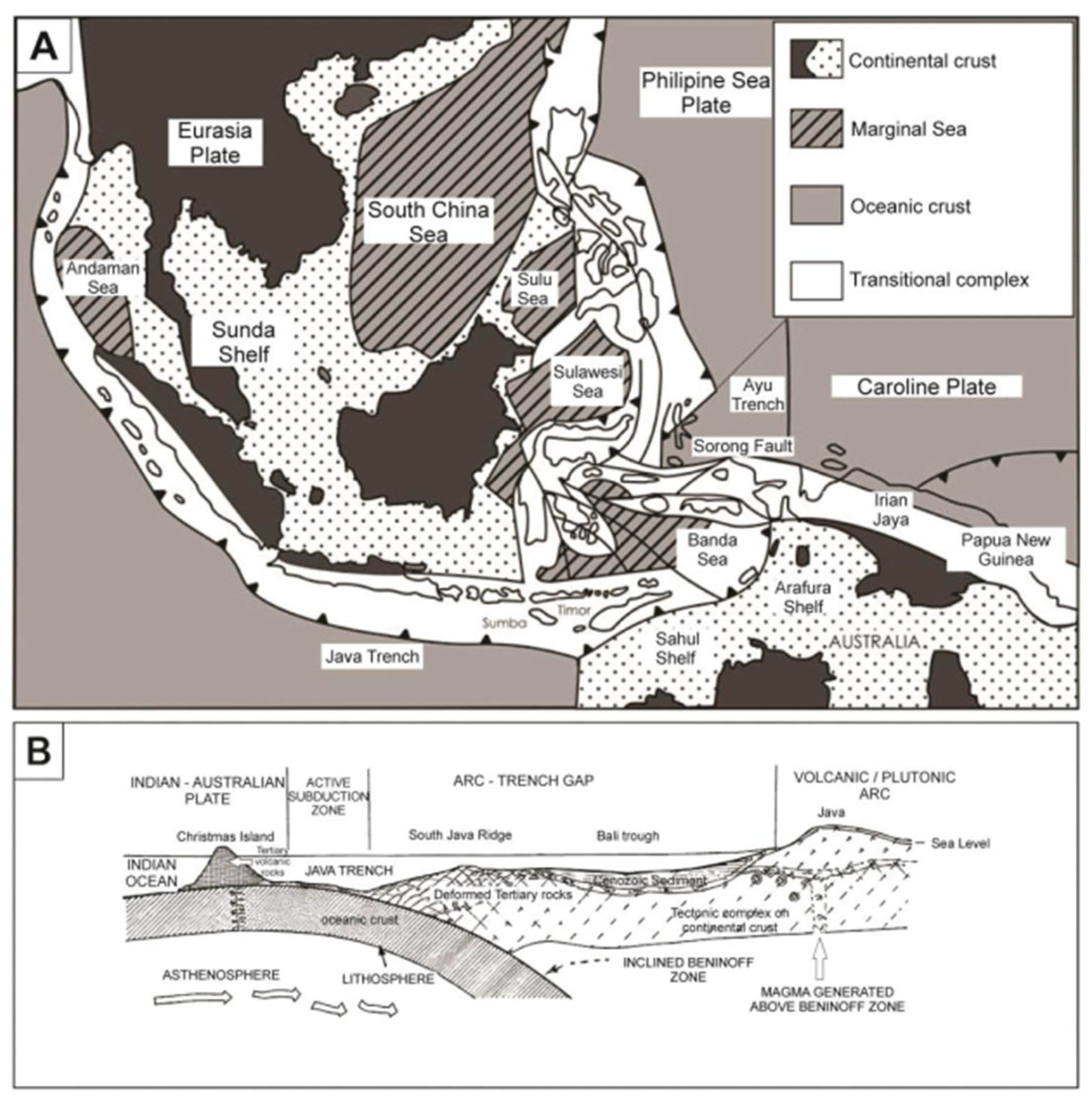
Figure 2.
Schematic illustration of the Java subduction system showing the subduction of the Indo-Australian Plate beneath the Eurasian (Sundaland) Plate. The figure highlights major tectono-geomorphic domains including the trench, fore-arc basin, Southern Mountains (Tertiary volcanic arc), and the Quaternary volcanic arc. Also shown are representative regional localities (Gunung Kidul, Menoreh, Bantul, Kebumen, Gombong) and the associated structural configuration, magma pathways, and crustal deformation patterns along the Java segment.
Figure 2.
Schematic illustration of the Java subduction system showing the subduction of the Indo-Australian Plate beneath the Eurasian (Sundaland) Plate. The figure highlights major tectono-geomorphic domains including the trench, fore-arc basin, Southern Mountains (Tertiary volcanic arc), and the Quaternary volcanic arc. Also shown are representative regional localities (Gunung Kidul, Menoreh, Bantul, Kebumen, Gombong) and the associated structural configuration, magma pathways, and crustal deformation patterns along the Java segment.
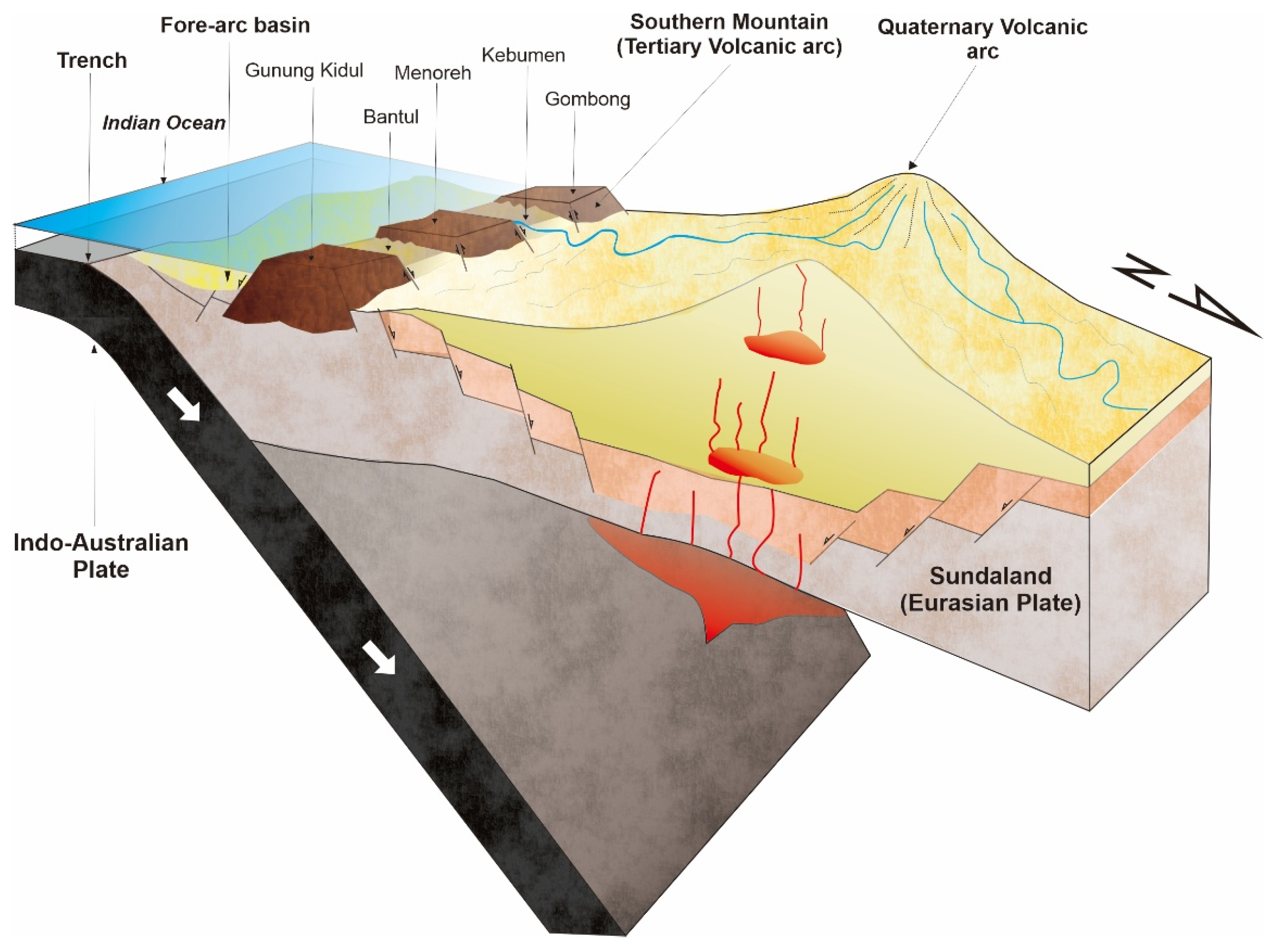
Figure 3.
Location of RTK-GNSS transects along the southern coast of Java, Indonesia. The transects were collected at four sites: Pantai Ajah, Kalijali, Kulon Progo, and Wingko, with red boxes indicating the specific survey areas.
Figure 3.
Location of RTK-GNSS transects along the southern coast of Java, Indonesia. The transects were collected at four sites: Pantai Ajah, Kalijali, Kulon Progo, and Wingko, with red boxes indicating the specific survey areas.
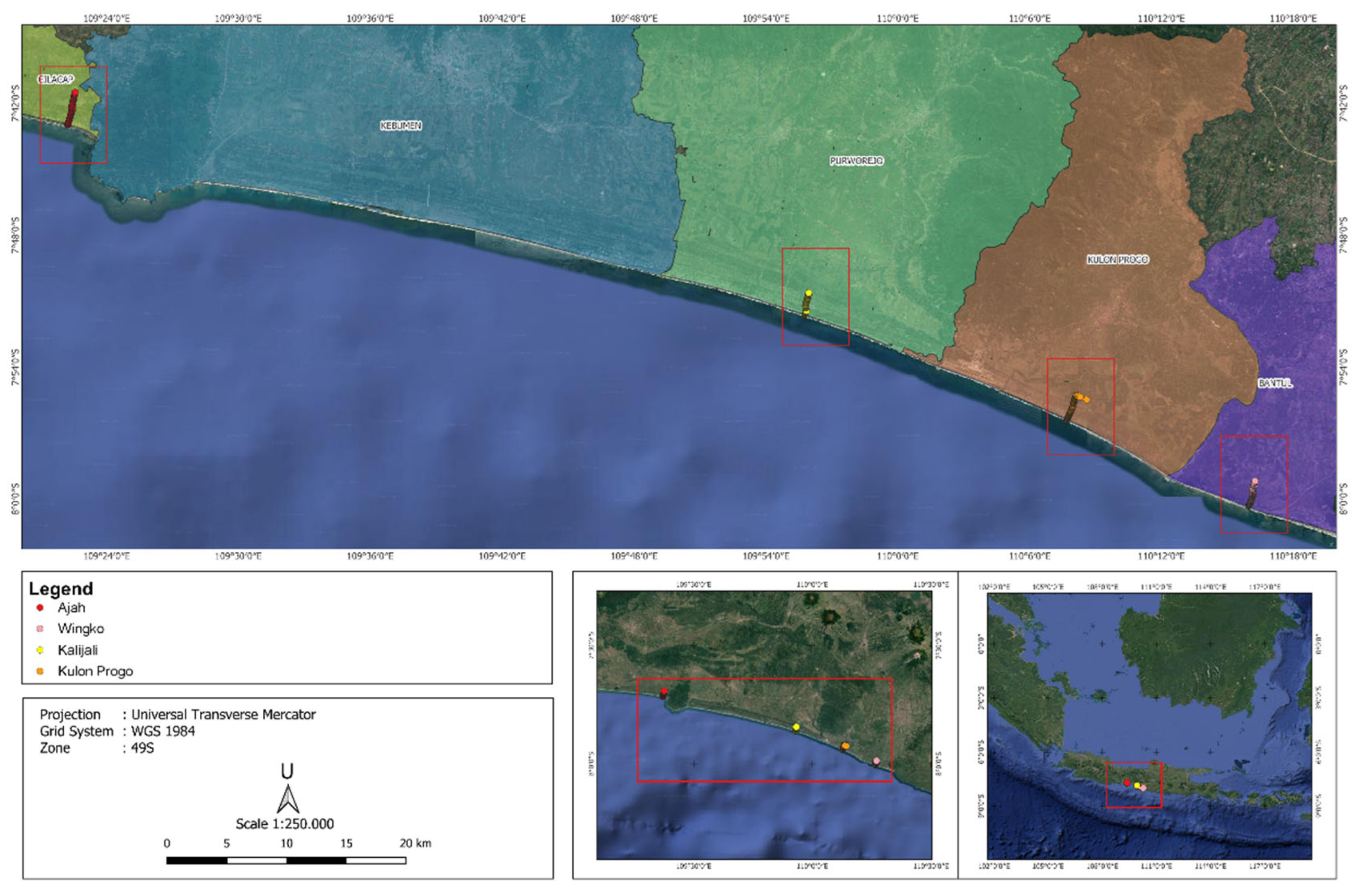
Figure 4.
RTK transect location and topographic profile of Pantai Ajah, Kebumen, Central Java.
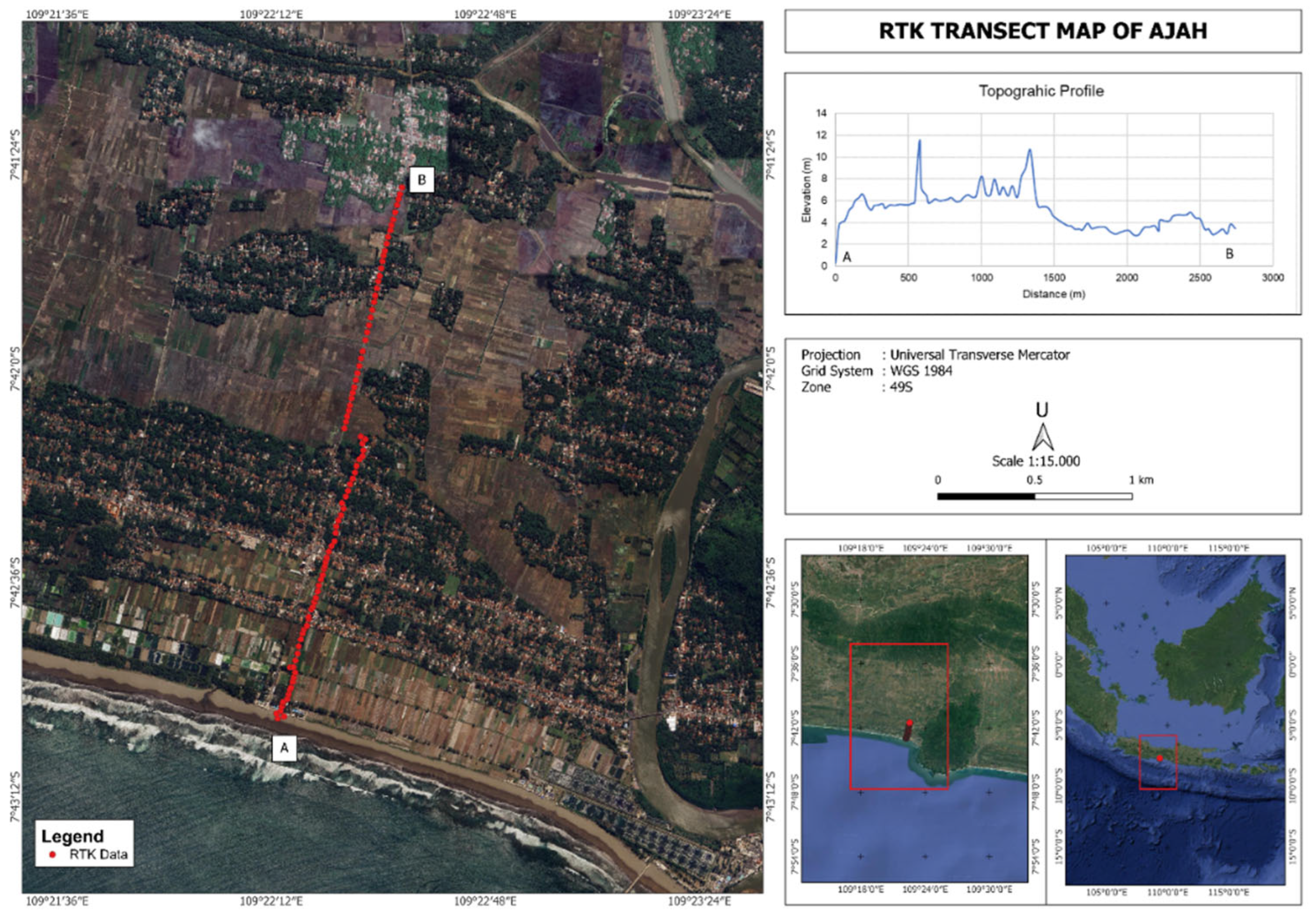
Figure 5.
RTK transect location and topographic profile of Kalijali, Purworejo, Central Java.
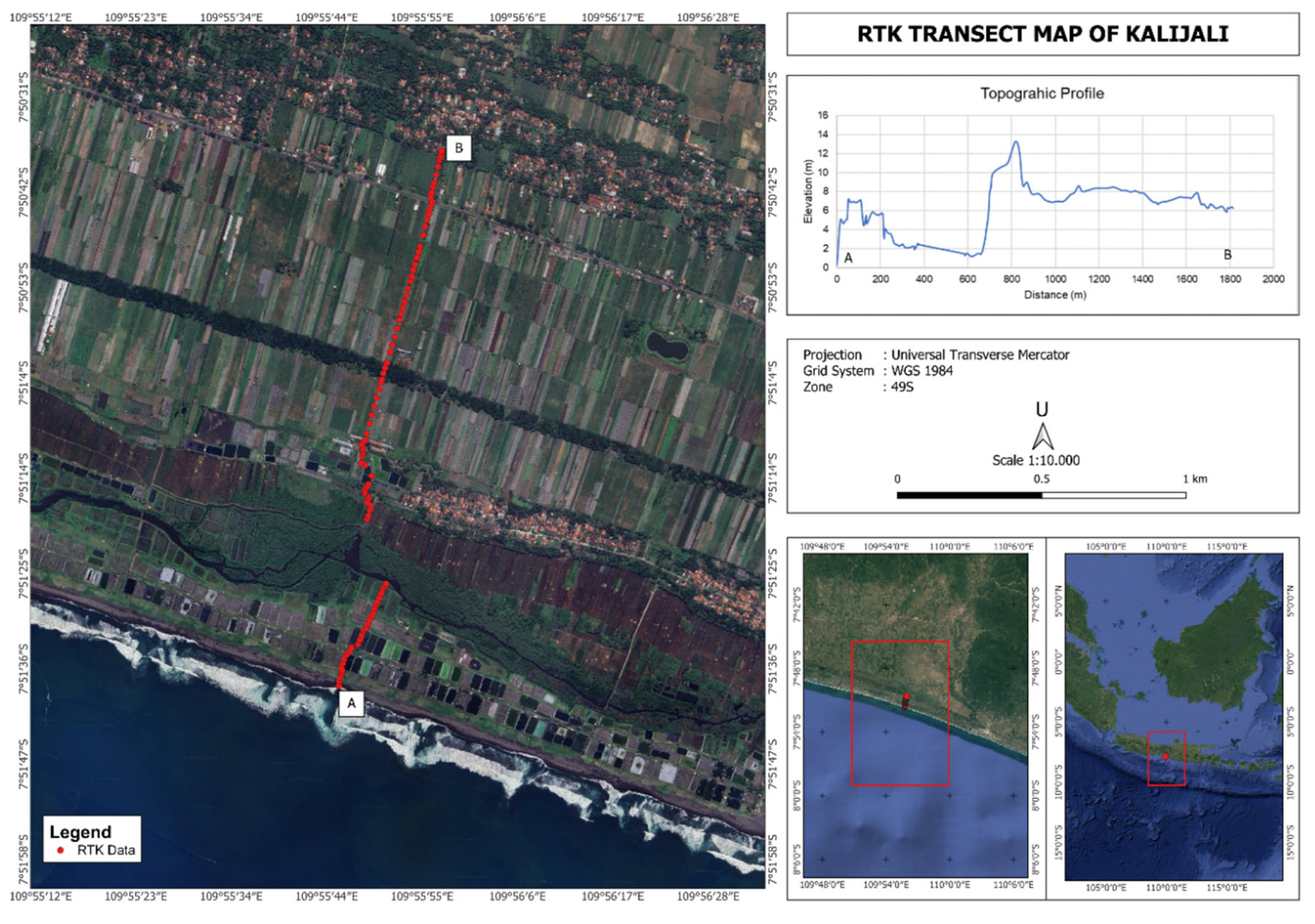
Figure 6.
RTK transect location and topographic profile of Kulon Progo, Yogyakarta.
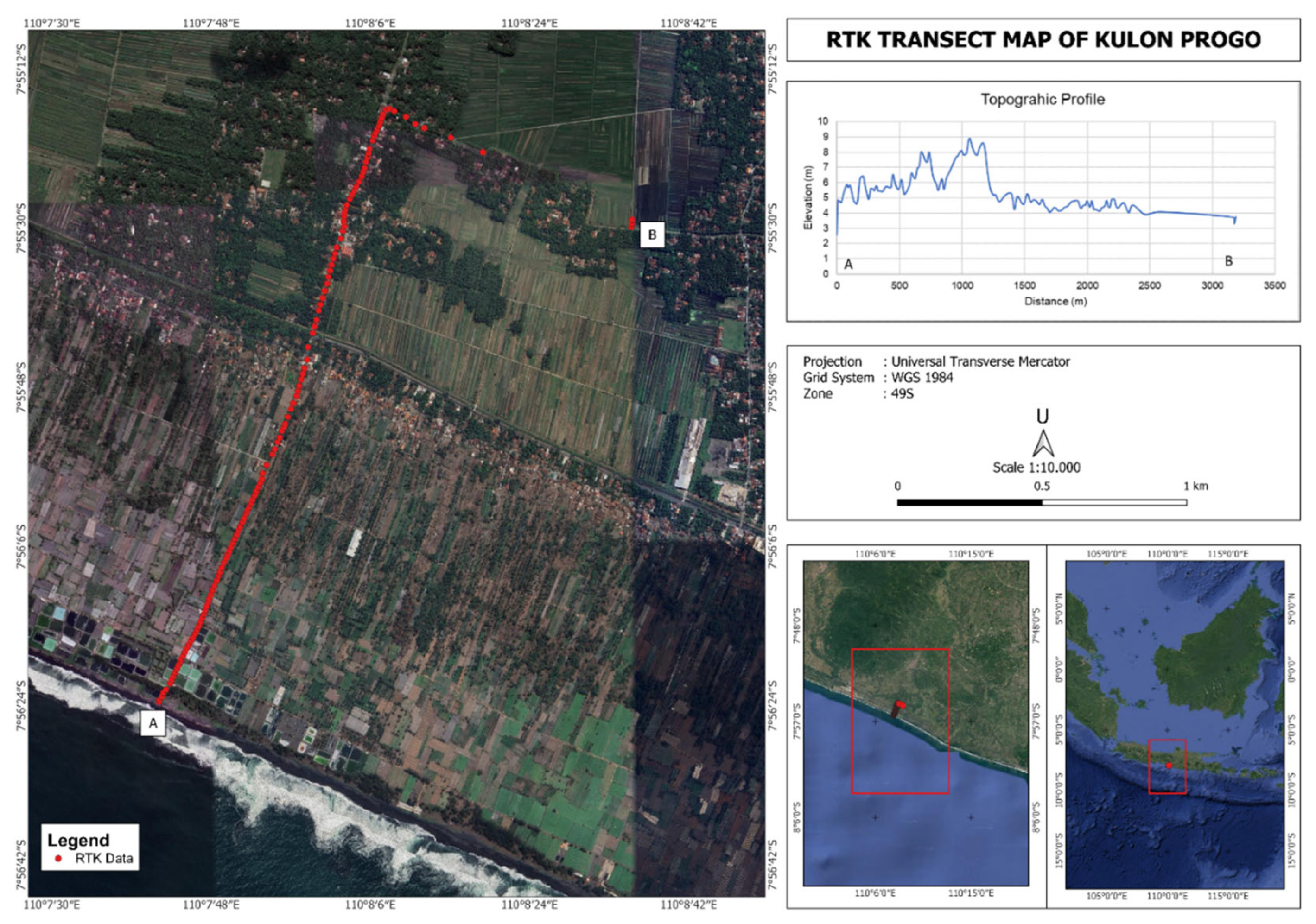
Figure 7.
RTK transect location and topographic profile of Wingko, Purworejo, Central Java.
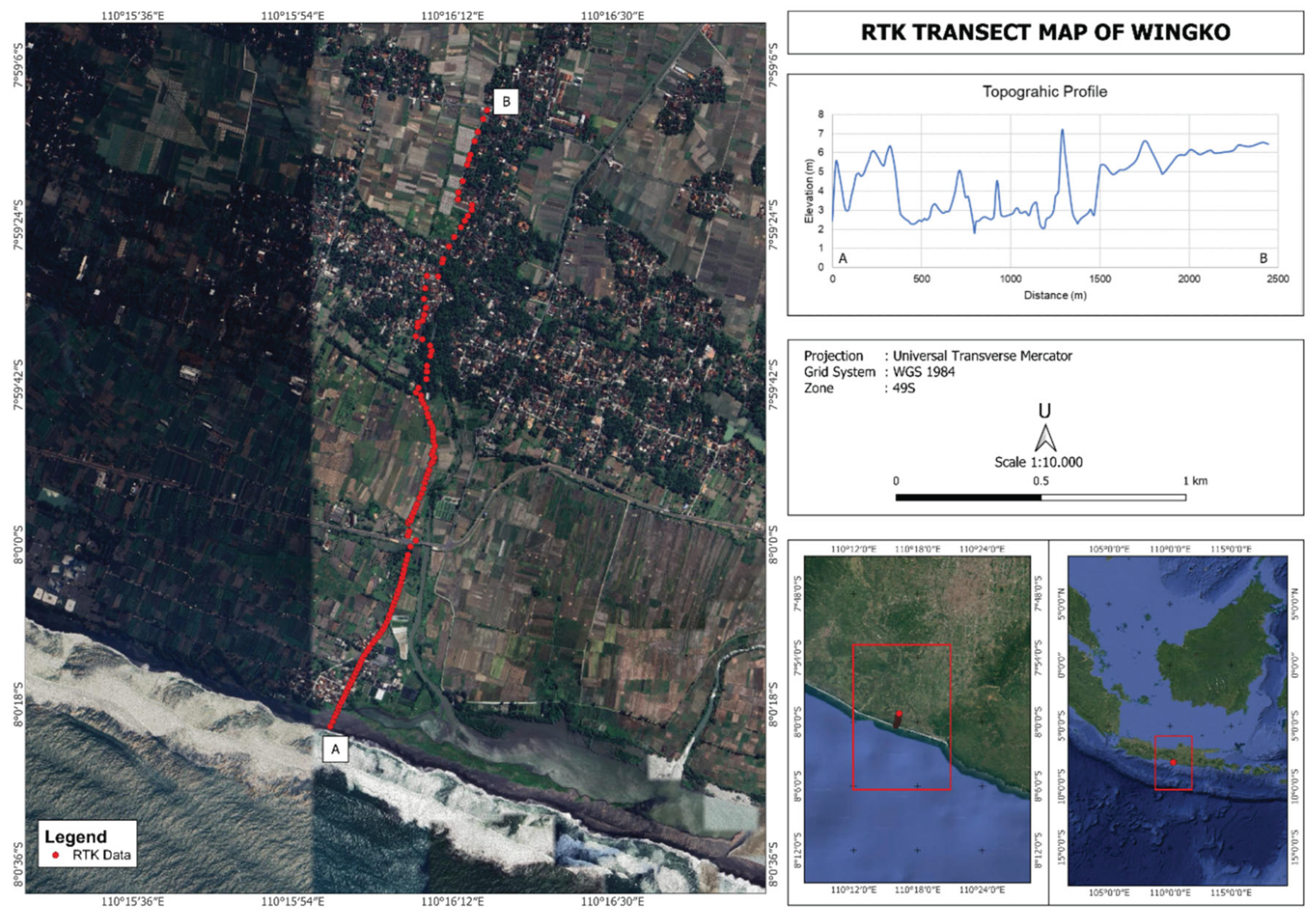

Table 1.
Preliminary site-level terrace data and inferred uplift rates based on previous studies.
| Site | Location (approx) |
Terrace level (m a.s.l.) |
Inferred uplift rate (mm/yr, MIS5e) | Source | Reliability / Notes |
|---|---|---|---|---|---|
| Southern coast | Pangandaran, Pacitan, Karanghawu, Pangamalang |
T1: 0-.5 m, T2: 2 m, T3: 17 m, T4: 22 m. | 0.17 | Andreini et al. [11] | High |
| Gunung Kidul | Gunung Kidul | Mean hill height ~90 m; coastal relief 25-100 m | 0.720 | Haryono and Day [12] | High |
| Gunung Sewu (coastal terraces) | Gunung Sewu / Teluk Pacitan area (approx) | 2; 6; 15-20; 40; 80 | 0.016 | Tjia [13] | High |
| Oyo River terraces (Gunung Sewu) |
Oyo River / Sadeng Valley | 45-60; ~105; 120-130 | 0.360 | Tjia [13] | High |
| Pantai Klayar | Klayar coast, Pacitan |
Abrasion platform 1.5-2 m above high tide; notch deepest cut 1-1.5 m above high tide | 0.012 | Tjia [13] | High |
| Bali—Sunda Arc | Bali / Sunda Arc examples | Notches up to ~7.4 m (Holocene markers) | 0.059 | Kázmér et al. [14] | High |
| Pangandaran & Lebak | Lebak, Pangandaran |
2-3 tsunami deposits in trenches/cores (1-2 m depth) | 0.016 | Putra et al. [15] | High |
| Regional compilation |
Southern Java (various) | Bibliographic compilation (no primary terrace data) |
van Gorsel [16] | Low—Medium | |
Note: uplift rates in column ‘Inferred uplift rate (mm/yr, MIS5e)’ are provisional estimates assuming terrace formation at MIS 5e (≈125 ka) when no age data are available. See ‘Reliability / Notes’ for source and confidence level.
Table 2.
Summary of Regional Uplift Characteristics.
| Region | Terrace range (m a.s.l.) | Estimated uplift rate (mm/yr, MIS5e) | Character |
|---|---|---|---|
| Lebak—Pangandaran | 2–3 | ~0.02–0.05 | Low uplift / interseismic subsidence |
| Gunung Kidul–Gunung Sewu | 2–80 | ~0.10–0.16 | Moderate long-term uplift |
| Pacitan—Klayar | 1–2 (Holocene notches) |
episodic (1–2 m/event) |
Short-term uplift / coseismic |
| Regional mean | — | ~0.10 | Consistent with long-term forearc emergence |
Table 3.
Tentative morphostratigraphic correlation of RTK-identified terrace surfaces and topographic highs between Pantai Ajah, Kalijali, Kulon Progo, and Wingko.
Table 3.
Tentative morphostratigraphic correlation of RTK-identified terrace surfaces and topographic highs between Pantai Ajah, Kalijali, Kulon Progo, and Wingko.
| Terrace / landform group | Elevation range | Locations included | Possible origin | Notes |
|---|---|---|---|---|
| Lower terrace group | ~4–6.5 m | Kalijali lower surface, Kulon Progo, Wingko | Possible low raised coastal platform, young marine terrace, or Holocene-related coastal surface | Most likely regional low terrace group, but still needs dating |
| Upper terrace group | ~7–9 m | Pantai Ajah, Kalijali upper surface | Probable higher marine terrace or older/more uplifted coastal surface | Strongest correlation in the dataset |
| Higher local highs | ~12–14 m | Kalijali high, Pantai Ajah high, possibly other isolated highs | Residual ridge, older terrace remnant, uplifted Holocene/highstand-related feature, dune/beach ridge, or bedrock high | Should be discussed as a working hypothesis, not a confirmed terrace level |
Disclaimer/Publisher’s Note: The statements, opinions and data contained in all publications are solely those of the individual author(s) and contributor(s) and not of MDPI and/or the editor(s). MDPI and/or the editor(s) disclaim responsibility for any injury to people or property resulting from any ideas, methods, instructions or products referred to in the content. |
© 2026 by the authors. Licensee MDPI, Basel, Switzerland. This article is an open access article distributed under the terms and conditions of the Creative Commons Attribution (CC BY) license (http://creativecommons.org/licenses/by/4.0/).
Copyright: This open access article is published under a Creative Commons CC BY 4.0 license, which permit the free download, distribution, and reuse, provided that the author and preprint are cited in any reuse.