
Submitted:
25 November 2025
Posted:
26 November 2025
You are already at the latest version
Abstract
In this study, we present the main phases of the reconstruction of the town of Bisaccia after natural disasters. Bisaccia is a small town in the hinterland of the southern Apen-nines (southern Italy), most recently hit by the earthquake of 23 November 1980. However, the urban and socio-economic development of the town was determined not only by the earthquakes of the past centuries, such as those of 1694, 1732, 1930 and 1962, but also and above all by the fragility of the terrain deposits on which it stands, that caused complex landslide phenomena on the territory. The earthquake of 1980 made it possible to rebuild the village on a different site, not far from the old settle-ment, resulting in the de facto coexistence of two villages, with all the problems that this entails. This article examines how Bisaccia town has historically adapted and re-sponded to seismic and hydrogeological crises with the aim of point up the sustainable development of Bisaccia inland areas. We collected a photographic documentation of the actual urban reality of Bisaccia reporting in detail modern 'atypical and utopian' new assessment of the town as desired by its creator, the architect Aldo Loris Rossi.
Keywords:
Bisaccia (southern Italy)
; earthquakes environmental effects
; post-earthquake urban reconstruction
; hydrogeological instability
; natural disaster resilience
; sustainability
1. Introduction
Reconstruction a town after a catastrophic event such as an earthquake is always characterized by numerous variables that make the path non-linear and the goal not always achievable [1 and references therein]. In addition to the political aspects which, always play a dominant role, there are technical, administrative, bureaucratic, social and economic factors that deeply influence the reconstruction process of the town [2 and references therein].
Sustainable development and reconstruction require a multifaceted approach that combines strategic planning, technological innovation, and community engagement. By drawing on international frameworks and integrating advanced technologies, regions affected by disaster can rebuild in a manner that promotes long-term resilience and equitable development [3,4].
Italy is one of the Mediterranean countries with the highest seismic risk, due to its peculiar geographic position at the convergence of the African and Eurasian plates [e.g. 5]. The most intense seismic activity is mainly concentrated in the central and southern part of the peninsula, along the Apennine ridge and in some northern areas in the Alps Chain [4]. Post-earthquake reconstruction has a long history in Italy, marked by diverse methods and outcomes. Looking back to the last century, Italy had to face numerous seismic events with very different reconstruction processes. Notable examples include the Belice earthquake in 1968 in Sicily (Southern Italy, Imax X MCS, Me 6.4) [6,7,8], the Friuli earthquake in 1976, (Northern Italy Imax X MCS, Me 6.5) [5,6,7], ending with and the devastating Irpinia-Lucania earthquake in 1980 (Imax X MCS, Me 6.9) [6,7,9,10,11]. These events had profound social and territorial impact and led implications were markedly different. In particular, these three earthquakes profoundly affected Italy’s social fabric and led to to markedly different reconstruction approaches [12 and references therein]. In his work, Caporale [12], analyses the experience of these three destructive earthquakes, proposes a cultural-systemic theory of natural disasters, focusing on how disasters are not just isolated physical events but are deeply embedded in the sociocultural and structural characteristics of a territory. He argues that disasters are an inherent part of socio-cultural systems and that integrating scientific knowledge of hazards with socio-cultural realities is necessary to mitigate them. He highlights the importance of eliminating negative disaster cultures for significant progress in disaster management. Clemente and Salvati [2], investigates post-earthquake reconstruction in Italy with a dual focus on physical landscape renewal and the social identity of affected communities. They analyze the two main approaches to reconstruction: a) the "new city" model, with new off-site settlements, aimed at security and urban renewal, disconnected from the social and cultural context; b) the "in situ" model: rebuilding on site, preserving the original physical and social fabric, embodying the idea of rebuilding "where it was, as it was," preserving collective identity and social cohesion and proposes strategic guidelines and governance models that promote community involvement and sustainability to reconcile urban renewal with the preservation of social identity. Lizarralde et al, [1], provide a comprehensive examination of the post-disaster reconstruction process with a focus on achieving long-term sustainability. Their work underlines the necessity of involving local communities in decision-making processes, coordinating multiple stakeholder government agencies, humanitarian organizations, and citizens and bolstering institutional capacity. They argue that sustainable reconstruction transcends restoring pre-disaster conditions to also reduce future risk through inclusive social, economic, and environmental integration.
The evolution of Italy’s reconstruction practices illustrates this complexity: starting from the 1968 Belice earthquake, marked by inadequate territorial planning and temporary housing that often became semi-permanent; progressing to the participatory reconstruction model in Friuli in 1976, characterized by active community engagement; and culminating in the 1980 Irpinia reconstruction, challenged by a complex legislative framework and controversies involving administrative mismanagement and criminal influences.
Within this national context, inland areas such as those in the inner Apennines present additional challenges for reconstruction. These territories are often defined by geographic isolation, demographic decline, limited infrastructure, and fragile geologic conditions. The depopulation of small inland towns is a widely discussed issue in scientific circles. Numerous publications have thoroughly investigated and presented research aimed at studying social and demographic dynamics, environmental and economic characteristics, together with demographic and anthropological surveys [12,13,14,15,16,17]
This interest is undoubtedly driven by the desire to protect the important local traditions, such as religious traditions, as well as typical food and wine products, local crafts, the area's distinctive architecture, and cultural heritage in general. This vast wealth defines the identity of the territories and allows diverse histories and cultures to survive even today. This has led to the adoption of programmes and actions aimed at safeguarding small inland towns, with the intention of limiting their significant demographic decline [19].
From this perspective, the case of Bisaccia, a small town located at 860 meters above sea level in the inner southern Apennines (Irpinia), is emblematic. The town is historically prone to both seismic activity and hydrogeological instability, particularly landslides, making its reconstruction after the 1980 earthquake especially complex. These challenges are compounded by the typical vulnerabilities of inland areas, including marginalization from national development policies and the risk of depopulation. The reconstruction of Bisaccia offers a compelling example of how such inner areas must navigate the dual pressures of hazard mitigation and territorial transformation. Over the past four decades, the town’s urban evolution has been shaped by an ongoing negotiation between risk, resilience, and identity. Reconstruction in Bisaccia did not only involve rebuilding structures, but also redefining the relationship between the historic town center and the newly developed settlement. This “dual existence” of the ‘old’ and ‘new’ Bisaccia reflects broader tensions between tradition and innovation, permanence and relocation, centrality and peripherally.
This article aims to examine how Bisaccia has historically adapted and responded to seismic and hydrogeological crises, with a particular focus on the 1980 earthquake. It addresses issues such as resilience, planning and collective memory in historically important areas that remained vulnerable to these types of events. The article is structured in several sections covering the geological and seismic setting, the historical overview of the impact of seismic events since 1694 and the re-construction efforts following the 1980 earthquake. It also provides reflections on the reconstruction process itself, highlighting the dual existence of ‘old’ and ‘new’ Bisaccia. The information gathered could also form the basis of a new sustainable tourism proposal for inland areas, enhancing their history and potential [16,19].
We structured the paper as follows: Section 2 describes the materials and methods, including the multidisciplinary data sources and analytical approach; Section 3 presents the results detailing seismic and hydrogeological impacts and reconstruction phases; Section 4 discusses implications, limitations, and sustainable tourism potential; Section 5 provides final remarks summarizing key findings and outlooks; Section 6 recaps the aims and main outcomes of the research
2. Materials and Methods
The study integrates a wide range of multidisciplinary data, including historical data (archival documents, administrative records, and historical photographs); cartographic data (historical and contemporary maps used to track spatial transformations, including post-1980 reconstruction plans), seismological and geological data (regional seismicity and land instability) (Figure 1).
These datasets contribute to knowledge of the urban and architectural development of the “old” and “new” townscapes. Databases were analyzed comparatively across different temporal phases to reconstruct the sequence of disaster impacts, responses, and territorial changes. Analytical criteria focused on damage assessment, population displacement, reconstruction policies, and socio-economic indicators [10,11,20,21,22,23,24,25,26,27]. Finally, the article contextualizes these findings within broader historical and scientific literature that outlines the political and economic transformations of Bisaccia and the inland Apennine region with a view of sustainability development.
In addition, we compare the results of this peculiar Bisaccia condition with other locations in Italy such as Gibellina in Sicily and Hokudan in Japan and part of Taiwan. These examples provide a more relevant interpretation of the case study within a general context and highlights how 'disaster' can contribute to the development of tourism in these places.
2.1. Data Sources and Analytical Approach
We organized the data sources into three different databases: a) historical data; b) cartographic data; c) seismological and geomorphological geological data, organized as following:
- Historical database including: archival documents, such as those collected and published in the catalogue of strong earthquake in Italy and in the Mediterranean area CFTI5Med [28], as well as Alfano's 1930 report [29], and detailed monographs published in recent years by Galli and Gizzi on the 1930 earthquake [30,31,32]; administrative records containing historical details on reconstruction in Irpinia, such as Mazzoleni and Sepe 's book [10], as well as the acts of the parliamentary commission of inquiry [33], and the documented reconstruction of administrative acts of the municipality of Bisaccia (1980-1996) published in 2020 by an administrator from the time of the 1980 earthquake [34]; historical photographs documenting past earthquakes and reconstruction phases, including images of the reconstruction in Irpinia [10], and the most recent images of the reconstruction in Irpinia, photographs taken after the 1980 earthquake until a few years ago by Spiga and Porfido [20,21,24,35],
- Seismological and geological databases including: the seismic history of Bisaccia analyzed by Rovida et al. 2022 in the seismic catalogue CPTI15 [6] and by Guidoboni et al., 2019 in CFTI15med catalogue [28], as well as from the analysis of detailed historical monographs [29,30,31,39] for the 1930 earthquake and from detailed scientific studies relating to the 1980 earthquake [25,40,41,42]; numerous scientific papers detailing geological and geomorphological setting with particular focus on landslide phenomena triggered by earthquakes in the Bisaccia area [38,43,44,45,46,47,48]. Additionally, we analysed data from field surveys and documentation of both the “old” and “new” townscapes [24,49].
The data were compared across temporal phases to reconstruct disaster impacts, assess damages, track population displacement, and identify socio-economic trends. This comparative method integrates spatial, historical, and geological perspectives to clarify the dynamics of reconstruction. Our analysis was carried out within a GIS environment using ArcGIS Pro (Esri software), which allowed us to process, generate, and interpret all collected data.
3. Results
3.1. Two villages called Bisaccia
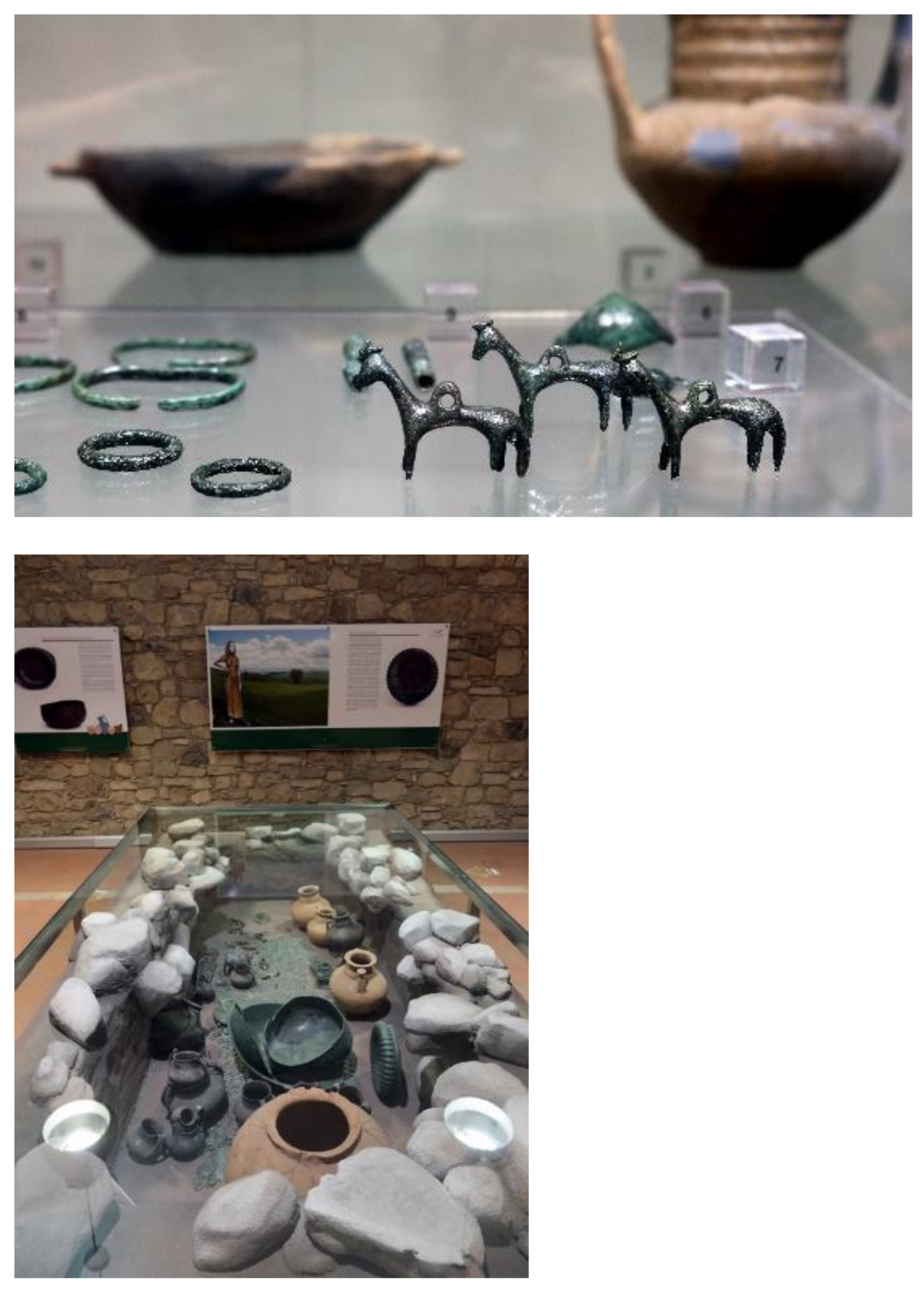
Today there are two places that make up Bisaccia (Figure 2): the old and ancient village with its medieval plan, recovered around the Ducal Castle and the Cathedral (Figure 3, Figure 4) and the new Bisaccia of the "Piano di Zona" (zone plan), the result of the intricate changes linked to the reconstruction after 1980, based on the urban plan designed by the architect Aldo Loris Rossi (Figure 2, Figure 5), professor at the Federico II University of Naples, originally from Bisaccia [24]. Bisaccia has a rich and interesting historical-archaeological past, with the earliest evidence dating back to the Neolithic period, with numerous finds in its territory, including a necropolis dating back to the 9th-8th centuries B.C., the most important remains of which are preserved in the local Civic Archaeological Museum (Figure 6, a, b) [23]. The remains of a rural villa and a sanctuary discovered in Oscata (village part Bisaccia) date back to the late Roman period. The historic centre dates back to the Longobard period, as evidenced by the wall structures near the square tower of the local ducal castle (Figure 3). The Norman cathedral was rebuilt several times after earthquake damage, the last time in 1747 (Figure 4)
Figure 2.
Map shows the location of the study area (a); the main territorial features of the ancient village of Bisaccia (on the right) and “new Bisaccia”(on the left) of the Zone Plan designed by the architect Aldo Loris Rossi (b).
Figure 2.
Map shows the location of the study area (a); the main territorial features of the ancient village of Bisaccia (on the right) and “new Bisaccia”(on the left) of the Zone Plan designed by the architect Aldo Loris Rossi (b).
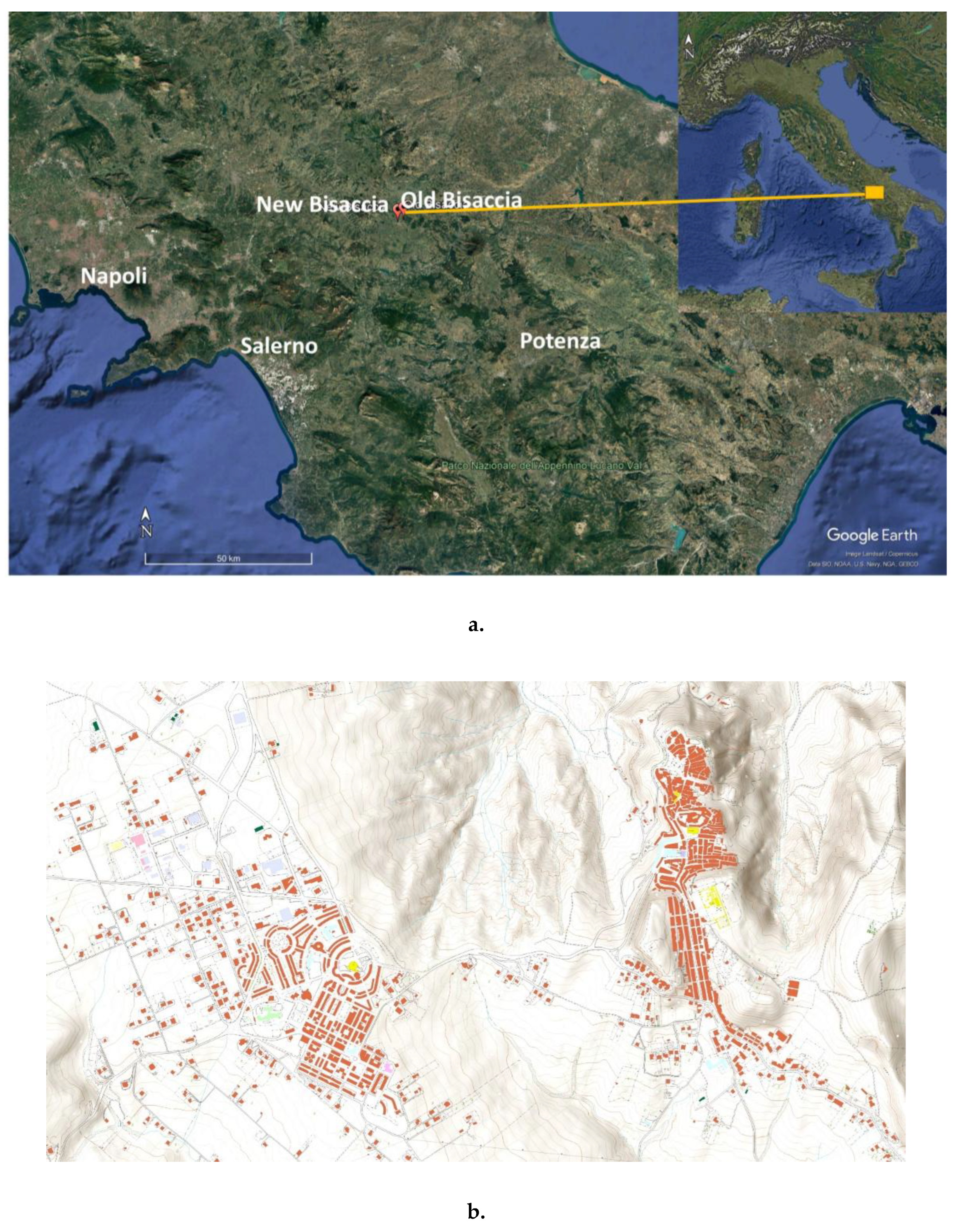
Figure 3.
The ducal castle of the old Bisaccia where is located the Civic Archaeological Museum (Photo from [26]).
Figure 3.
The ducal castle of the old Bisaccia where is located the Civic Archaeological Museum (Photo from [26]).
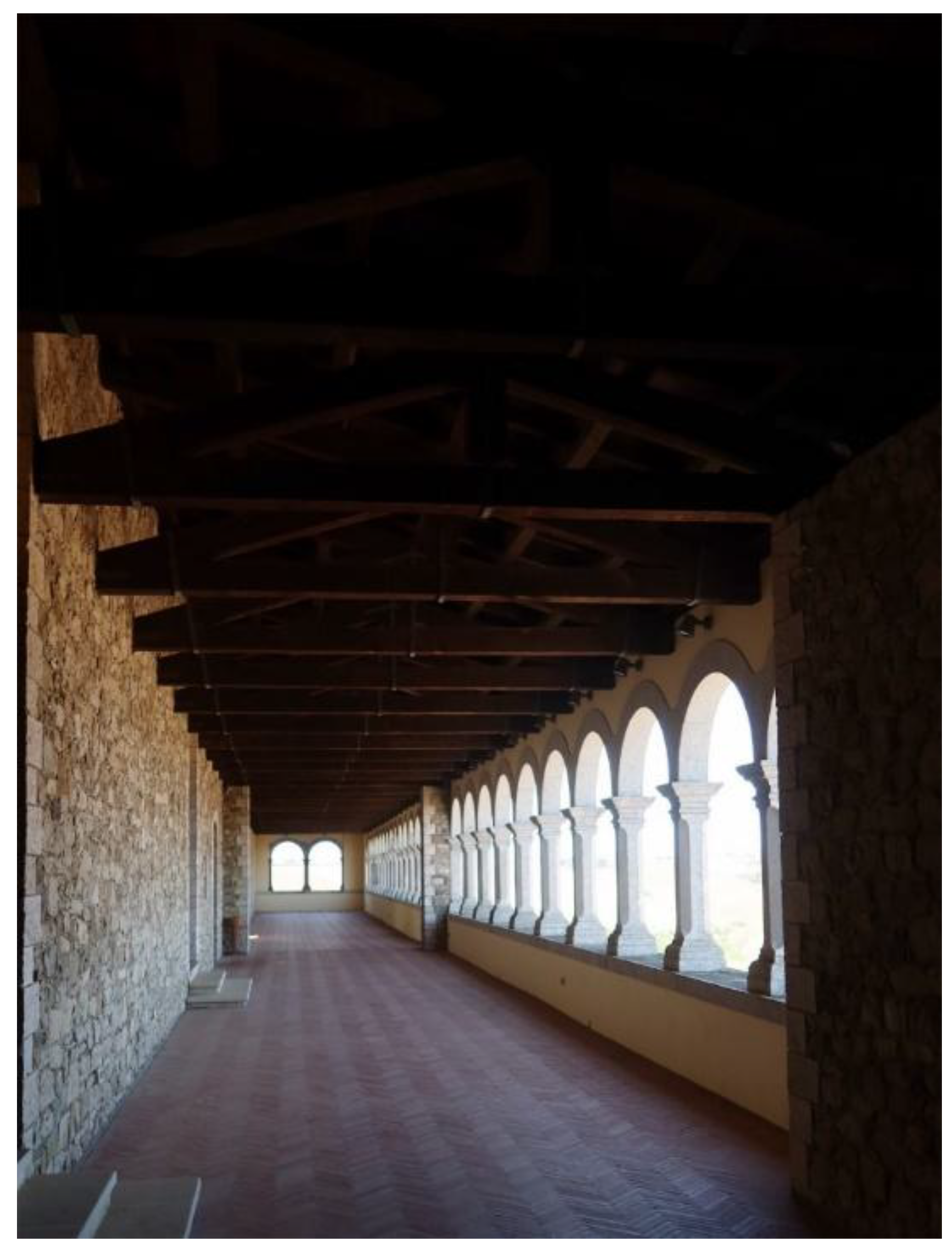
Figure 4.
The Norman cathedral of the old Bisaccia (Photo from [26]).
Figure 4.
The Norman cathedral of the old Bisaccia (Photo from [26]).
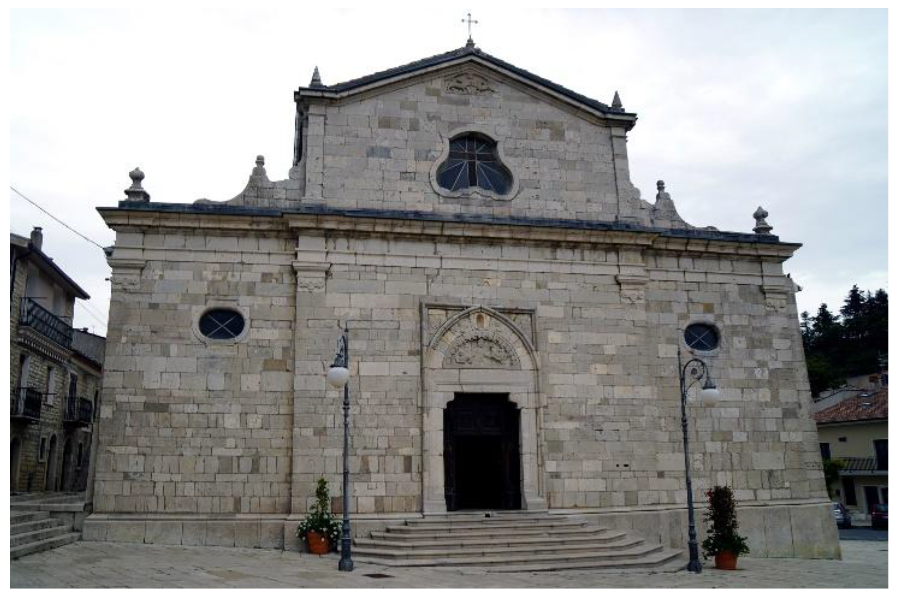
Figure 5.
The urban modern buildings of the new Bisaccia designed by Aldo Loris Rossi (a). Detail of church constructed after the Irpinia-Basilicata earthquake of 1980 as example of a circular architecture (Photo from [15,26]).
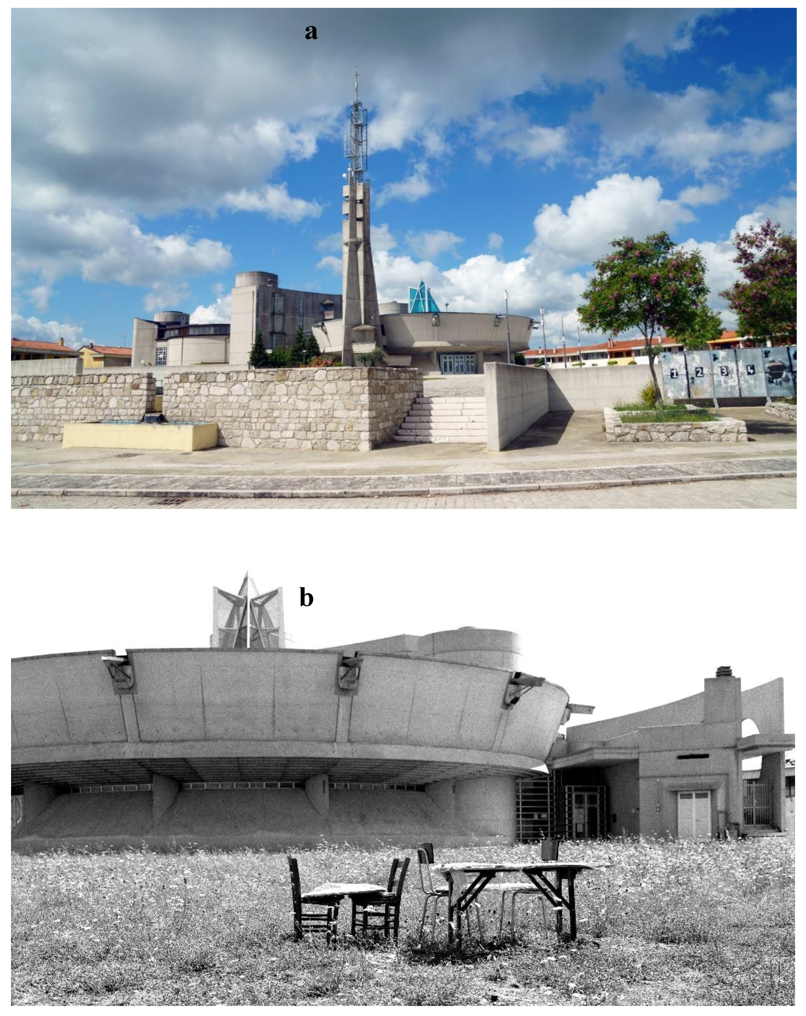
Figure 6.
Civic Archaeological Museum in Bisaccia (Avellino) on the top. The museum displays Neolithic artefacts on the bottom (Photo from [26]).
Figure 6.
Civic Archaeological Museum in Bisaccia (Avellino) on the top. The museum displays Neolithic artefacts on the bottom (Photo from [26]).
3.2. Bisaccia between hydrogeological instability and earthquakes
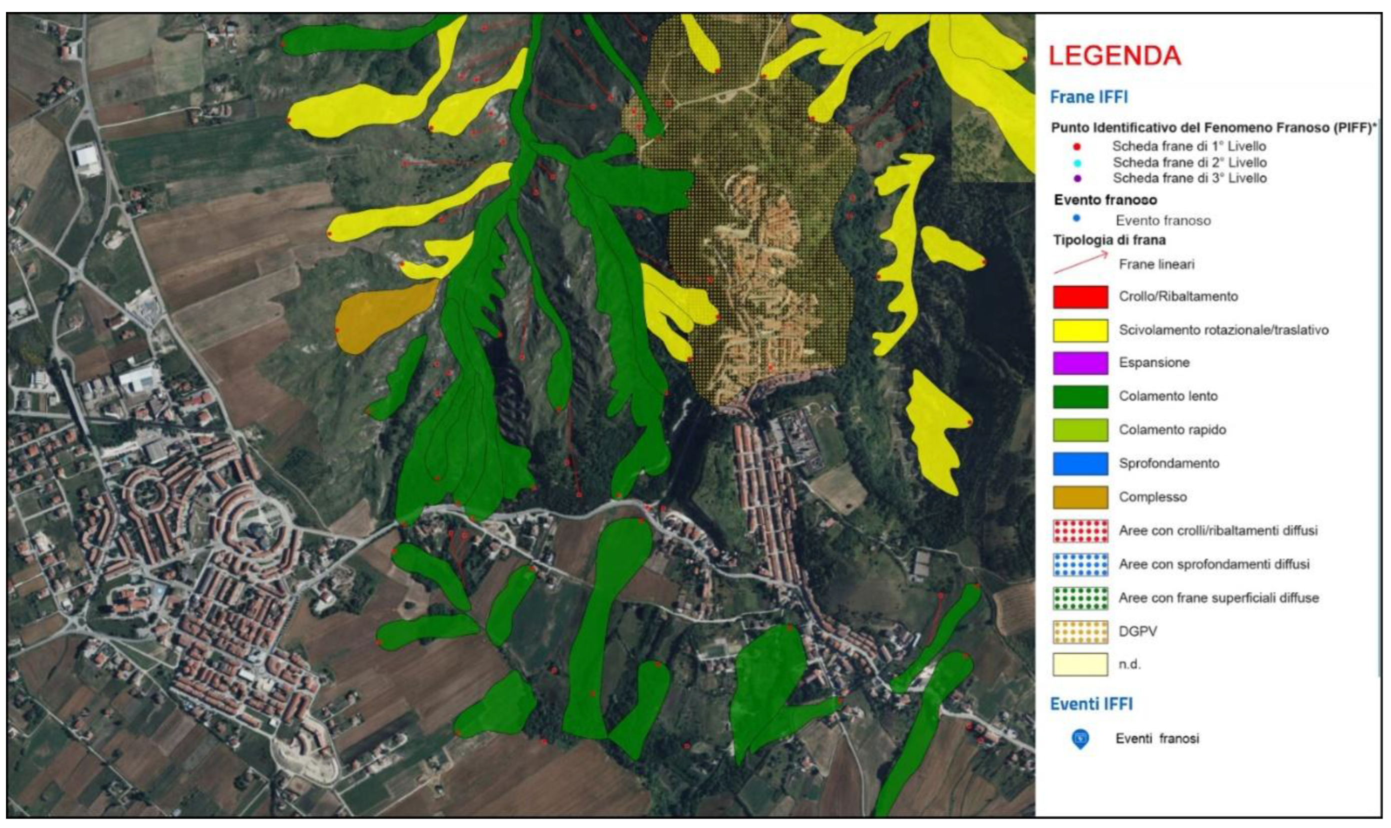
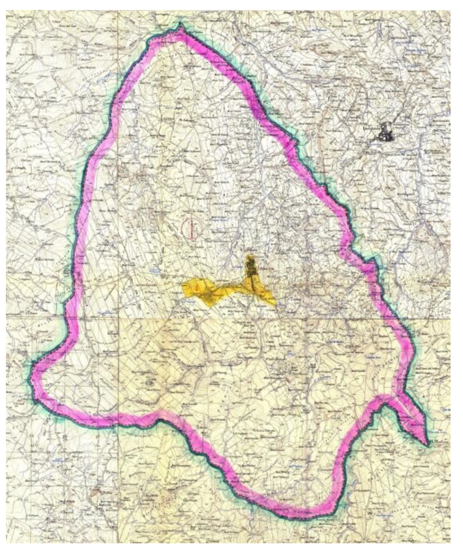
From a geological point of view, Bisaccia is characterized by a plate of Pliocene polygenic conglomerates, slightly cemented, resting on the "Varicolored Clays" formation, affected by extensive landslides of different typologies that have also occurred over the centuries [43,44,46,50]. Figure 7, Figure 8 shows various gravity phenomena, including the extensive rotational/translational sliding phenomena (in yellow), the slow displacements mainly affecting the varicolored clays (dark green), and the extensive Deep-Seated Gravitational Slope Deformations (DSGSD) phenomenon affecting the entire ancient city center and the northern zone (orange dashed line), as currently reported by the new Idrogeo platform of Ispra [38]. The hydrogeological risk scenarios reported on this platform indicate that landslides could affect 28.6% of the population, 35% of buildings, 28.5% of industries and services, and up to 93.3% of cultural heritage of Bisaccia [38].
Figure 7.
Overview of the old town of Bisaccia, with the ducal castle tower in the centre and the Argille Varicolori geological formation in the foreground (Photo from [26]).
Figure 7.
Overview of the old town of Bisaccia, with the ducal castle tower in the centre and the Argille Varicolori geological formation in the foreground (Photo from [26]).
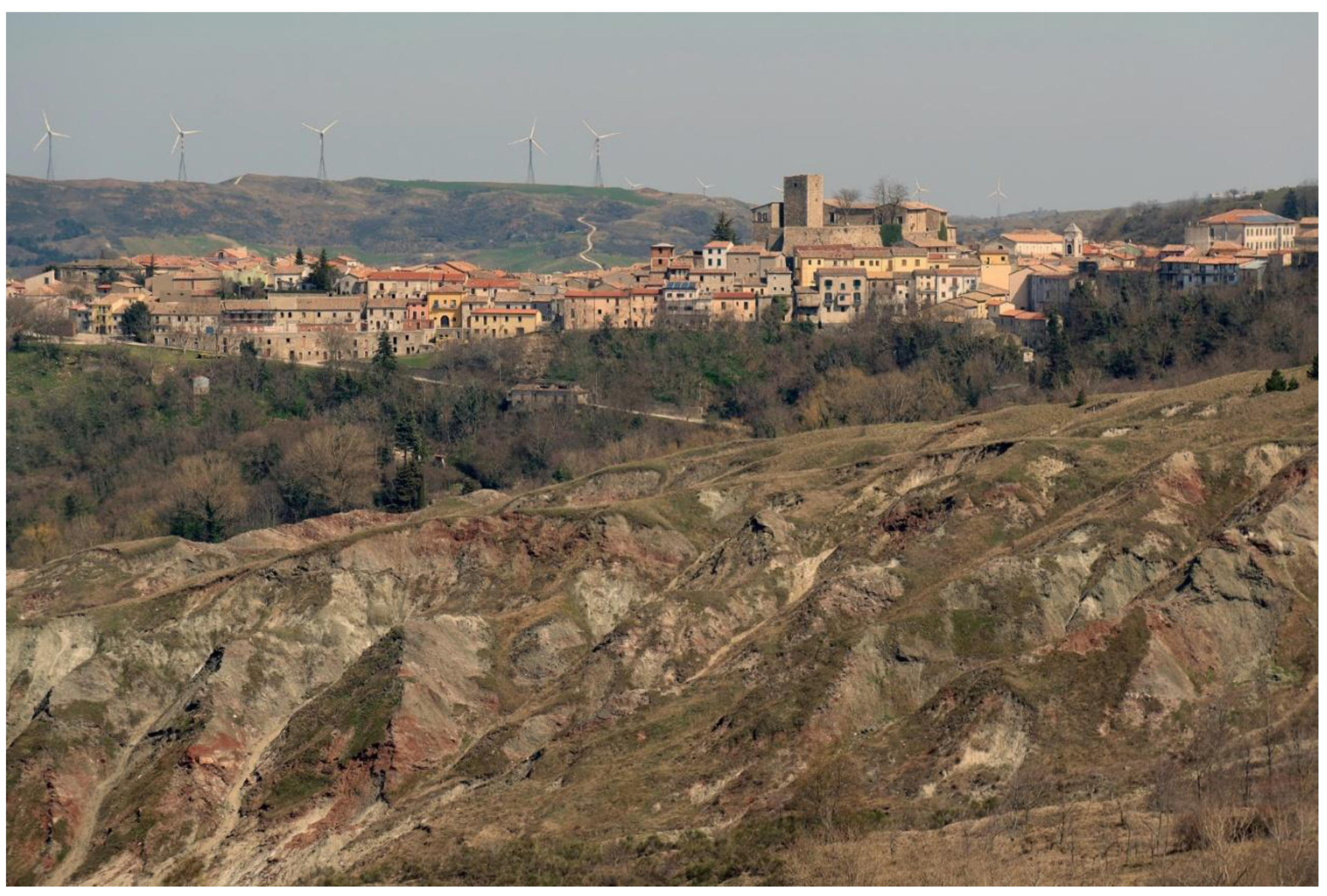
Figure 8.
The ancient Bisaccia surrounded by numerous gravitational phenomena including the extensive rotational/translational sliding phenomena (in yellow), the slow displacements mainly affecting the varicolored clays (dark green), and the extensive DGPV phenomenon affecting the entire ancient city centre and the northern zone (orange dashed line), as reported by IDROGEO platform of Ispra [38].
Gravitational movements which, not surprisingly, were reactivated and extended after the numerous seismic events that had the Southern Apennines as their epicentre.
The town is in a seismic zone, classified in the first seismic category by Delibere Giunta Regionale Campania no. 5447 of 7.11.2002. It has been severely hit by earthquakes in 1158, 1349, 1456, 1694, 1732, 1930 and 1980, as detailed on the municipal website [23].
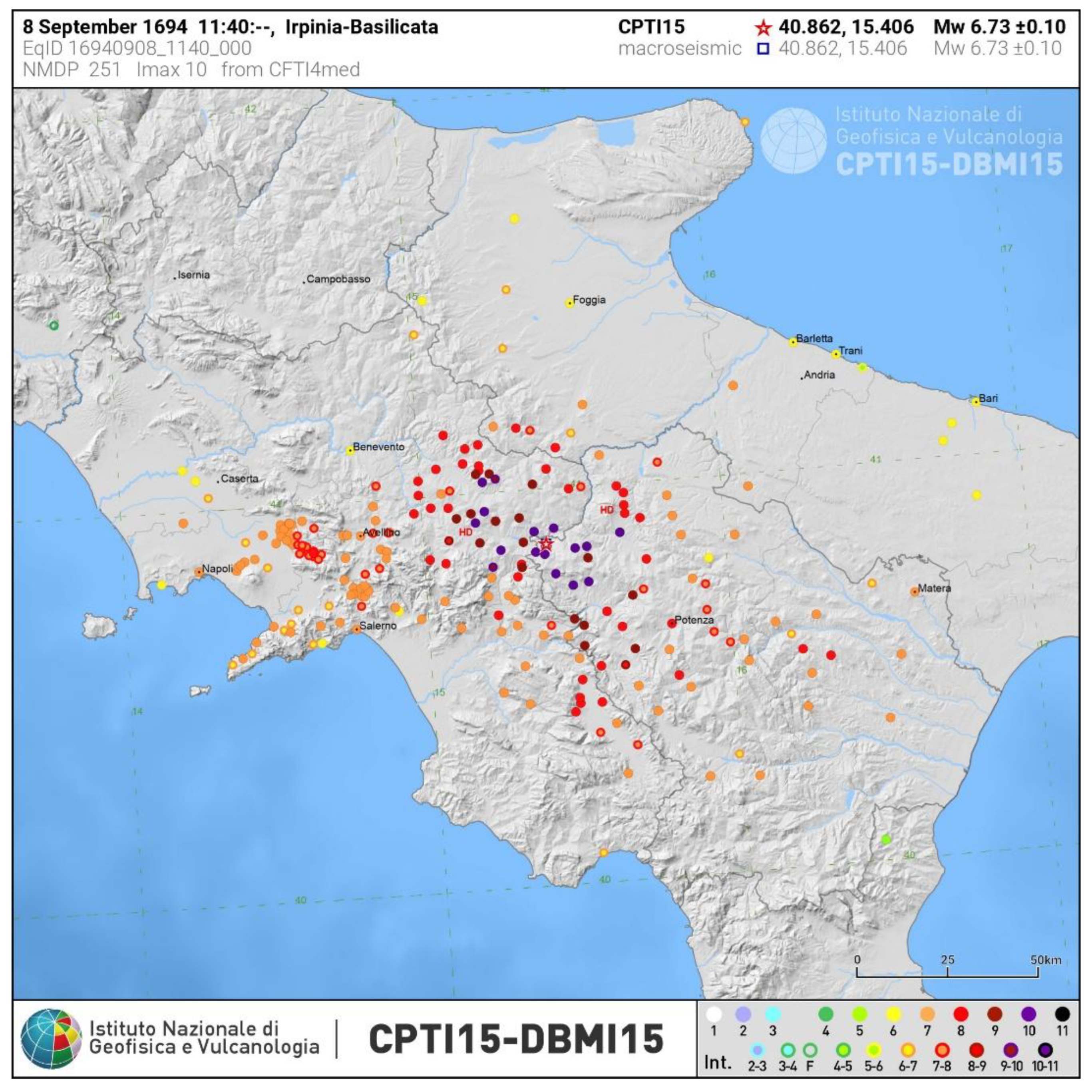
Of the strongest earthquakes to have affected Bisaccia, causing high levels of damage (I ≥ VIII MCS), the 1694 earthquake is notable, as it had its epicentre in Irpinia and Basilicata. Other notable earthquakes include those centred in Irpinia in 1732 and 1930, and the devastating earthquake of 1980 [6,40,41,42], (Figure 9). In 1694, Campania and Basilicata were severely struck by the earthquake (epicentral intensity I0=XMCS; M=6.8), which almost completely destroyed Bisaccia: around 200 houses and several churches collapsed: the cathedral, the bishop's palace and the convent of the Minor Conventuals were severely damaged and partially collapsed, eight deaths and numerous injuries, causing an intensity level of IX MCS (Figure 10 ). The earthquake triggered landslides and ground failures [6,28,35].
Figure 9.
The seismic history of Bisaccia (Avellino province), as recorded in the INGV seismic catalogues, indicates significant damage levels of I≥VIII MCS following the powerful Apennine earthquakes of 1694, 1732, 1930, and 1980 [6].
Figure 9.
The seismic history of Bisaccia (Avellino province), as recorded in the INGV seismic catalogues, indicates significant damage levels of I≥VIII MCS following the powerful Apennine earthquakes of 1694, 1732, 1930, and 1980 [6].
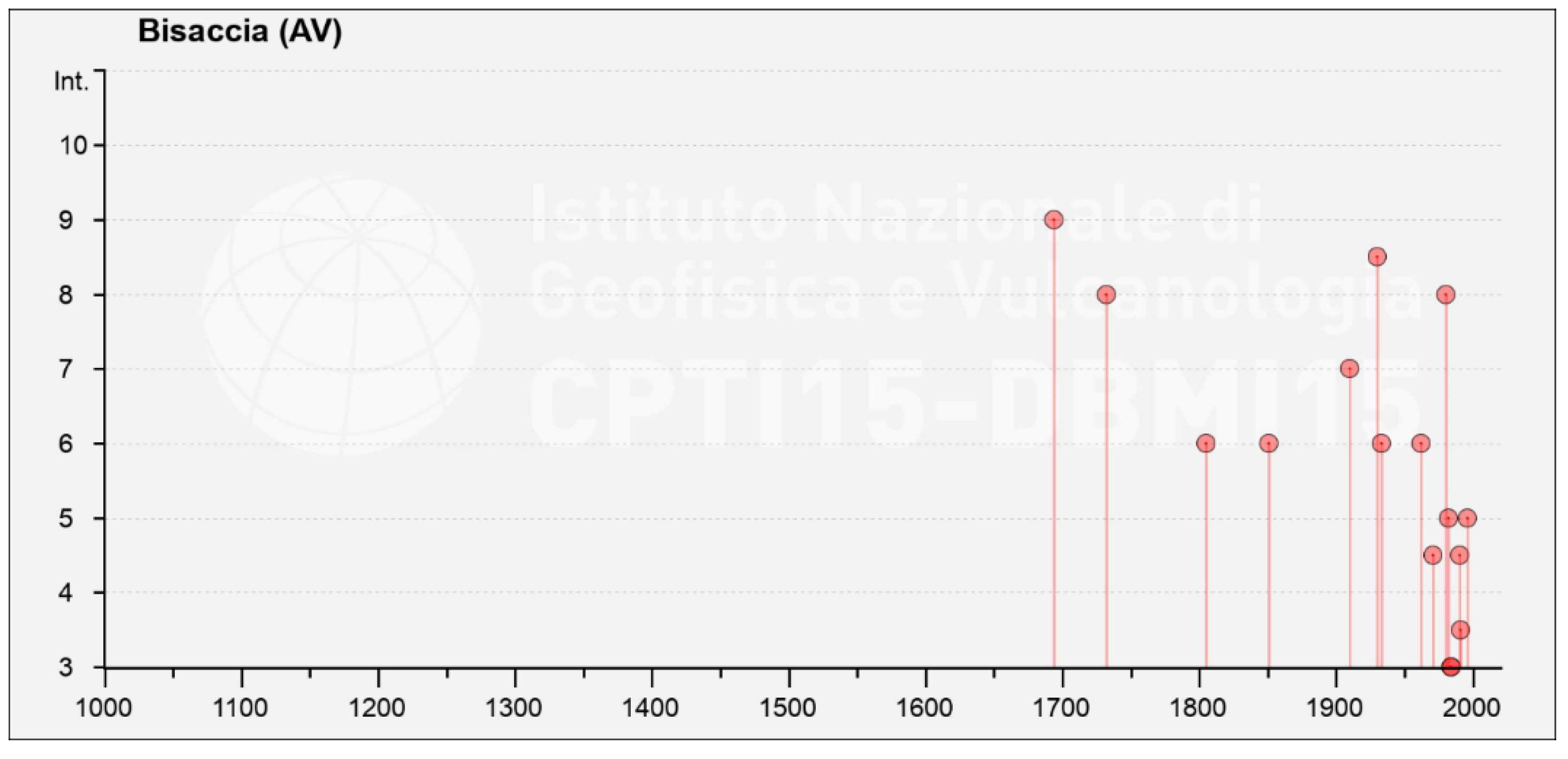
Figure 10.
The 1694 Irpinia -Basilicata earthquake, macroseismic field [6].
Figure 10.
The 1694 Irpinia -Basilicata earthquake, macroseismic field [6].
Severe damage was also caused to the architectural heritage by the 1732 Irpinian earthquake (I0= X-XI MCS; M=6.7): “…the mother church and fifteen houses have all fallen; and the church and convent of S. Francesco and the remaining houses have been rendered uninhabitable, but only one person died there...” [51] Reaching an estimated intensity of VIII degree MCS (Figure 11).
Figure 11.
The 1732 Irpinia earthquake macroseismic field [6].
Figure 11.
The 1732 Irpinia earthquake macroseismic field [6].
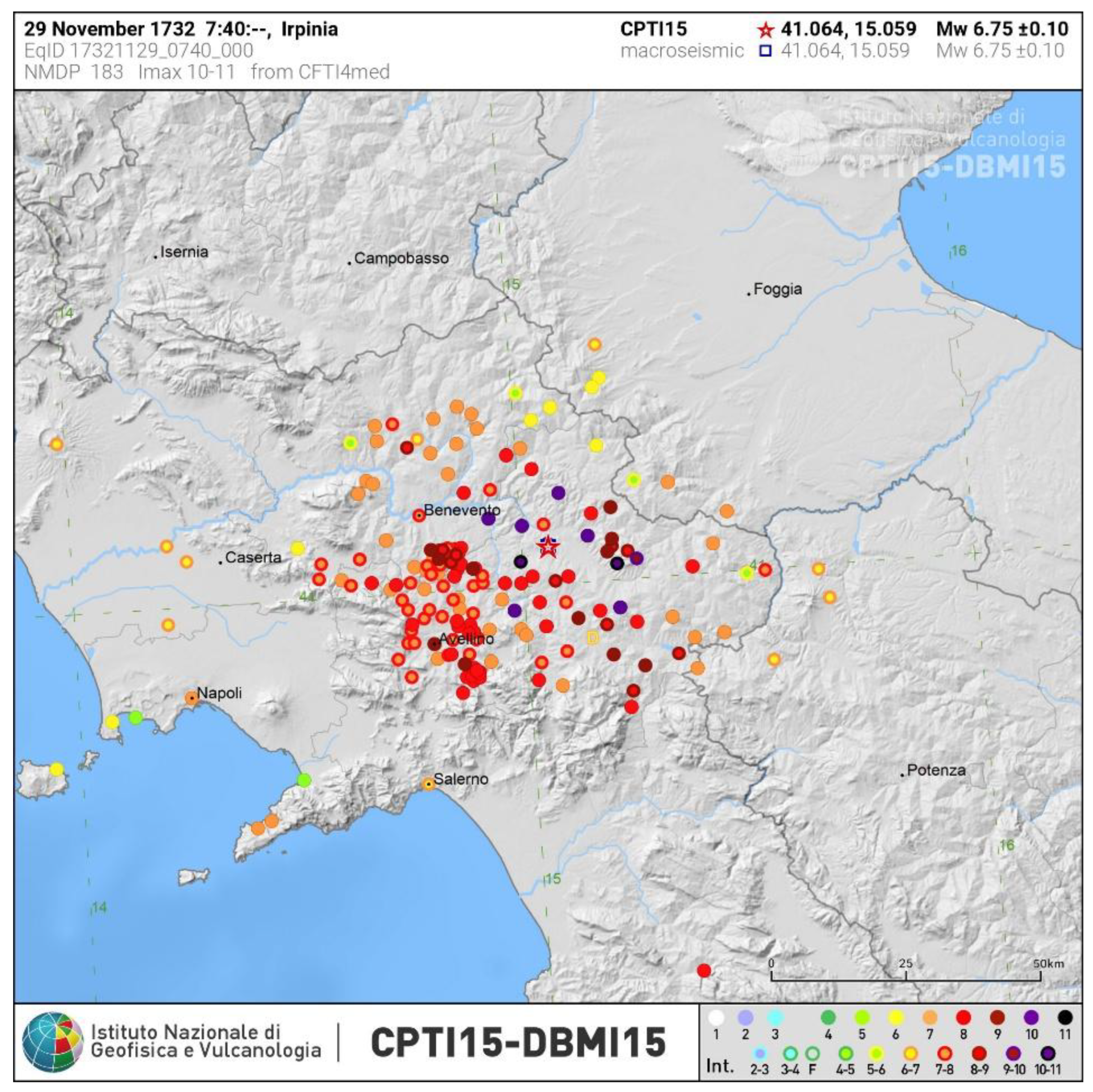
Figure 12.
The 1930 Irpinia earthquake macroseismic field [6].
Figure 12.
The 1930 Irpinia earthquake macroseismic field [6].
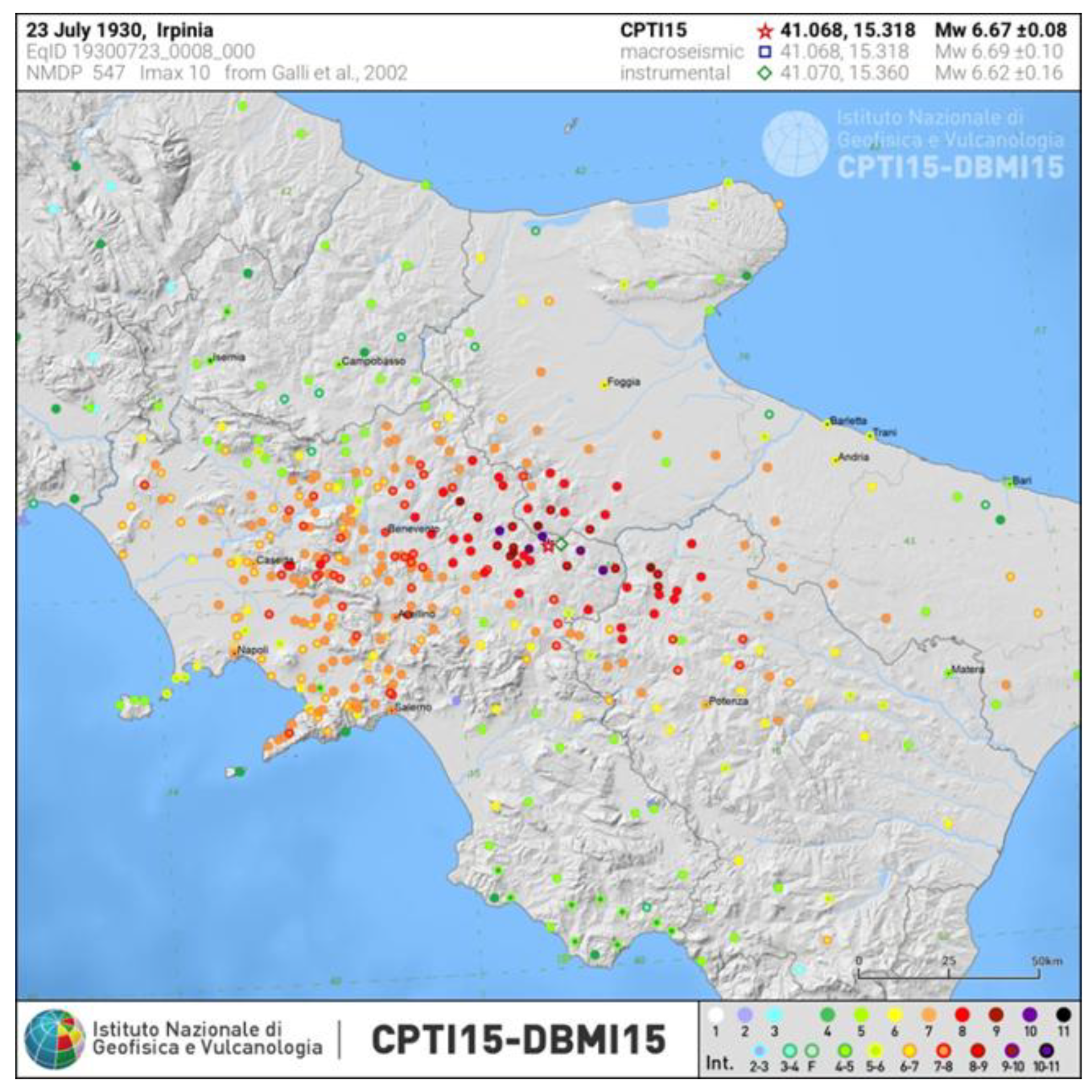
Less serious was the damage caused by the seismic event that mainly affected the Vulture area (Basilicata region) in 1851 (I0= XMCS; M=6.5), many cracks in the walls of the houses were caused by the earthquake, with estimated intensity of VI MCS [6,52]. In the 20th century, Bisaccia suffered the effects of seismic events, including the highest energy earthquakes of 1930 (I0= XMCS; M=6.6 (Figure 12) causing the death of 1404 people [28] and 1980 (I0= XMCS; M=6.9) causing about 3000 victims, which in addition to causing considerable damage of I=VIII-IX and I=VIII MCS, respectively, contributed to the extension and propagation of extensive pre-existing landslide phenomena [35,40,41,42,43,44,45,46,47,48].
Both earthquakes had a considerable impact on the environment in fact, in some areas of the town, numerous deep cracks were observed, which also affected the road network, causing differences in elevation of tens of centimeters and exacerbating the already precarious instability of the steep slopes bordering the town [46,47,48].
The earthquake of 23 July 1930 in Irpinia caused in Bisaccia 150 houses to collapse and 1400 to be damaged, with 18 deaths and many injuries.
The greatest damage was in the eastern part of the town, as reported in the Official Document [53] “Bisaccia - The whole eastern area in landslide, which includes the districts of Piazza, in part, Campanile Vecchio, Rupe Andreone and S. Chirico. This area is bounded on the left of the impluvium line by Via Campanile Vecchio, the outer boundary of maps 456, 462, 163, 470, 485 Largo Santoro, Vicolo Vescovado Vecchio, Largo Piazza, excluding the section of Via dei Fiori up to map 629, the outer boundary of maps 620, 610, 530, 527, 830, 324, 299, 317, 298, 282, the first section of Via Rupe Andreone up to the small road below maps 261 and 264 ,the outer line of maps 210, up to the convent garden” [37,38,39,40,41,42,43,44,45,46,47,48,49,50,51,52,53].
After the 1930 earthquake, it was decided to move the town to Boscazzulo-Cappella a locality of Bisaccia, about 1.5 km to the west of the town historical centre, precisely because of the numerous geological instabilities and the resulting damage to the urban fabric. This move, however, did not take place until after the 1980 earthquake, even though Bisaccia had been hit by other gravitational phenomena in the meantime, such as the one in early 1965, which also led to the evacuation of numerous buildings [30,31,46]. For the reconstruction of Bisaccia and of the most damaged towns hit by the 1930 earthquake, such as Aquilonia, Scampitella, Villanova del Battista, Lacedonia, Vallesaccarda, Anzano di Puglia, Ariano Irpino, Melfi, Montecalvo Irpino, Barile, Castel Baronia, Flumeri, etc., the Fascist government of the time opted for the construction of new buildings [54,55]. The new constructions were called " casette asismiche- aseismic small houses", dwellings of a few square metres, built on a base of cement concrete and consisting of one, two or more rooms, as well as a kitchen and toilets, located mainly in areas not far from the ancient residential nucleus [29,39,56]. Many aseismic houses were also built in Bisaccia, some of which, 95 years after the earthquake, are still recognizable and used as dwellings beyond historical memory (Figure 13 a, b, c) as in the neighboring towns of Aquilonia, Scampitella, Trevico, Villanova del Battista and Carife [35,55].
The November 23, 1980 earthquake, the most powerful seismic event in Italy in the last hundred years, became the de facto political-administrative tool for the reconstruction of the town. In fact, although the earthquake did not cause extremely significant damage to the housing stock, which was classified as VIII MCS [40] (Figure 14), it once again highlighted the extremely unstable conditions of the outer edges of the conglomerate plateau on which most of the historic centre is built (Figure 7, Figure 8). The mayor of Bisaccia in 1980 was the Senator of the Italian Republic, Salverino De Vito, of the Christian Democratic Party, worked hard to rebuild the village elsewhere with government funding [33,34]. The geological instability identified and documented at the time of the earthquake by numerous technical reports by groups of geologists and engineers, including academics from the Italian Universities of Ancona and Naples, reiterated the need to relocate part of the town: “Any option other than moving part of the historic centre of Bisaccia to another area would, in the opinion of the authors, mean postponing to another date the serious problem of Bisaccia, which has been dragging on for many decades. It would be truly illogical not to consider the serious risks to which the population is exposed, both in terms of landslides and seismicity. If we do not want to wait until in the coming decades a disaster on the scale of those that have recently struck the towns of Conza, Lioni, Pescopagano, etc., will finally and tragically close the issue “[57]. It is not by chance that the historical map (Figure 15) shows that the whole area was subject to hydrogeological restrictions [37]. The various municipal administrations that succeeded one another after the earthquake decided to rebuild the town in the area of Boscazzulo-Cappella, which had already been identified after the 1930 earthquake and was more stable from a geological point of view, called 'Piano di Zona'.
Figure 14.
Isoseismal lines of the Irpinia-Basilicata 1980 earthquake (After [40]).
Figure 14.
Isoseismal lines of the Irpinia-Basilicata 1980 earthquake (After [40]).
Figure 15.
Historical map of the hydrogeological constraints of the municipality of Bisaccia. In green, the boundary of the municipal territory coincides with the fuchsia band that delimits the area subject to hydrogeological restrictions [35].
Figure 15.
Historical map of the hydrogeological constraints of the municipality of Bisaccia. In green, the boundary of the municipal territory coincides with the fuchsia band that delimits the area subject to hydrogeological restrictions [35].
The new Bisaccia of the Zone Plan, built almost entirely according to the urban plan drawn up by the architect Aldo Loris Rossi of the University of Naples, originally from
Bisaccia, is a peculiar, "visionary" architectural layout, reminiscent of a utopian, futuristic city where reinforced concrete prevails (Figure 16 a, b)
His work reveals the influence of Frank Lloyd Wright's architecture, particularly his use of circular layouts. Significant examples include the church and the multi-functional centre. Figure (16 a, b). The latter, which was designed in 1981, is structured as a covered square overlooked by seven functional units. Each unit opens onto the central core, which serves as a hub for public events. It also shows the influence of the theoretical concepts proposed by Le Corbusier and early 20^(th) century Soviet circular architecture [58,59].
Although it did not meet with the approval of the population, it is a clear and decisive testimony of the change after the catastrophe (it could be compared to a modern Cerreto Sannita, destroyed by the earthquake of 1688 and rebuilt in the valley with a regular architectural layout, which is still functional today due to its earthquake-proof characteristics [42,49,60]. The post-earthquake reconstruction work (Figure 1, Figure 17) also included the IACP social housing scheme, again designed by Aldo Loris Rossi, with modern but not very functional buildings, oversized in relation to real needs, which will probably be completed this year. An affair that has lasted more than forty years, beginning in 1981 with the financing of no fewer than 83 social housing units, later reduced to 79 in 1987, with subsequent modifications over the years reducing the number even further. Finally, in 2014, the last project was approved, which provided for the urban and structural rehabilitation of only 18 flats [50,61].
4. Discussion
Post-earthquake reconstruction is a highly complex and ongoing topic of debate shaped by a variety of factors. These include primarily the geographical location and socio-economic condition of the affected communities, the impact of the earthquake itself, and the lack of effective, long-term strategies to promote economic development and local employment.
The process of reconstruction after an earthquake is invariably lengthy and involves several stages, often categorized as the emergency phase, the transition phase, and the main reconstruction phase [8,9,10,11]. Contemporary historiography has extensively examined these issues, emphasizing the contradictions that often arise due to political interference in reconstruction efforts, which can lead to persistent criminal phenomena [12,33,34,62,63]
It should be reiterated that Bisaccia is located in the inland Apennine area, consisting mainly of mountainous, rural regions along the Apennine ridge. These regions suffer from depopulation and lack infrastructure and services. These complex situations require the involvement of the population, structural political interventions and, above all, economic investment, as is widely reported in the literature [e.g. 64-66],
The National Strategic Plan for Internal Areas 2021-2027 [Piano Strategico Nazionale delle Aree Interne 2021-2027 (PSNAI) [67] has also been the subject of considerable controversy notably because of a passage that many local governments deemed 'unacceptable' Specifically, the document states that 'these areas cannot set themselves any goals to reverse the trend, but neither can they be left to their own devices'. They need a targeted plan to accompany them on a path of chronic decline and ageing.' Considering this, politicians and especially local administrators should seek alternatives beyond occasional weekend tourism or food festivals. Instead, they need to foster sustainable tourism that acknowledges and capitalizes on the distinctive features of the territory. Bisaccia, like much of the Upper Irpinia region, is affected by these challenges. Addressing them is crucial to promote growth and rejuvenation in these inland areas. Starting from this premise, we presented the iconography of Bisaccia's reconstruction following the 1980 earthquake. We highlighted how earthquakes and hydrogeological instability have influenced the city's urban development, albeit in an extremely concise manner.
These phenomena have had a strong and dramatic impact on the town's decision to relocate. However, thanks to the resilience of its inhabitants, two versions of Bisaccia have coexisted: 1) the historic old town with its cathedral and ducal castle; 2) the new, modern centre (Figure 19). This has not yet been fully appreciated by the local population and is the expression of a visionary and utopian project by the architect Aldo Loris Rossi [34,62]. It took a very long time to complete and is undesirable for a community that should have the opportunity to 'revive' in a dignified way after a disaster.
It is only in recent years that this architect has been re-evaluated, particularly within academic circles. In fact, an exhibition and conference were held in Bisaccia on 10 May 2025, with a proposal to establish the first contemporary architecture park inspired by his work [68]
We could call the coexistence of these two realities added value, but it should be given equal dignity and elevated to the forefront. This could create the conditions for those 'sustainable' tourist routes that are often discussed but never implemented. While the overview we have provided is certainly not exhaustive, the photographic images that we have selected deliberately show the reconstruction rather than damage. They are intended to give the reader a glimpse of the urban development of villages, with a view to safeguarding the territory and cultural heritage. Furthermore, they document the reconstruction process, revealing the human impact on the natural landscape and our ability or inability to correctly interpret a place's environmental destiny.
In addition, it must be said that the inland areas, although they have had a great opportunity for reconstruction and development, have never received a real boost towards a truly different economy, an economy that should have been the driving force behind agriculture, an economy that should have taken into account the new realities. In a town like Bisaccia, where the historic centre is still struggling to recover itself, where abandonment is still rife and where the new is not understood by the inhabitants, it was necessary to focus on an idea of sustainable tourism, perhaps based on the geological peculiarities on which the town is built, based on a path of guided geological excursions that highlight the peculiarities of the area, from the geomorphology to the erosion phenomena and the active landslides present.
Examples can be found in Italy [69] and all over the world, for example in Japan, where there are fault museums, at Hokudan, a museum that attracts thousands of tourists [70]. The museum has displays on the devastation caused by the 1995 earthquake, with the main display in a long hall that exposes a preserved section of the Nojima fault. Also, the 921 Earthquake Museum of Taiwan is dedicated to the M 7.3 magnitude earthquake that struck central Taiwan in September 1999 [71]. There are also very important examples in Italy: in Gibellina (Sicily), destroyed by the 1968 Belìce earthquake, the Cretto of Gibellina by the artist A. Burri, commissioned by the farsighted mayor, is a powerful and evocative example of the preservation of memory beyond the tragedy that is only apparently buried by concrete [72,73]. Similarly, the two sites representing Bisaccia could become a 'diffused museum' or 'open-air museum' by creating permanent laboratories for university geology and architecture students to explore themes such as natural hazards and different construction methods. If properly organized with tourist information panels, it could also be of interest to the public. In fact, Bisaccia could serve as a laboratory for studying geological and seismic risks, raising awareness among the local population and in neighboring countries with similar characteristics. In this sense, Bisaccia is a real-life laboratory where we can learn useful lessons from the past to help us deal with future seismic events and more.
Last but certainly not least, towns such as Bisaccia, located in the heart of the southern Apennines but not far from major urban centres such as Naples, could play a fundamental role, especially given the serious bradyseismic crisis affecting the Phlegraean Fields and parts of Naples. Rather than considering relocation to areas far from the original centres in the event of a red alert the population could be temporarily relocated to these mostly uninhabited locations so that people do not lose contact with their homes and loved ones and can return home within a few hours [74]
Despite the limitations imposed by the vastness of the subject, our work aims to encourage local authorities and the public to promote the territory that can certainly be described as unique and irreplaceable. This is in line with the wise advice of Vito Teti in his book “La restanza” (2022) [75], which proposes a new approach to narrative and action in rural areas. This involves taking initiatives that go against the grain, investing in the present and in residents, while avoiding welfare dependency.
5. Final Remarks
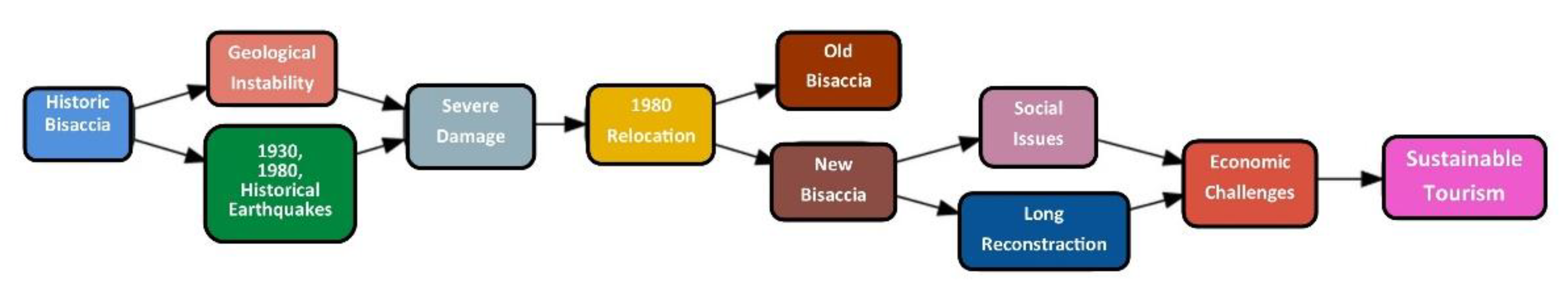
The results of this work highlight a complex interaction of natural hazards, resilience, and socio-political decisions of the Bisaccia urban evolution (Figure 20).
The following flowchart (Figure 20) summarizes the main phases of our study on the reconstruction of the town of Bisaccia, a city suspended between natural disasters and modern reconstruction. It shows the sequence of key processes that influenced the relocation and redevelopment of the town following the 1980 earthquake, with the coexistence of the old and new Bisaccia, suggesting the proposal to invest in sustainable tourism based on the town's geological and cultural heritage.
The main phases include:
• Dual urban identity: the coexistence of two urban realities, the "old" medieval historic center and the "new" Bisaccia, represents an example of resilience and territorial transformation.
• Influence of natural disasters: earthquakes and hydrogeological instability have had a significant impact on urban development, leading to the decision to rebuild part of the town in a more geologically stable area, after 1930 and 1980 earthquakes [30,31,32,34,35,37,39,42,50,53,55,57]
• Visionary project of urban reconstruction post 1980 earthquake: the new Bisaccia, designed by architect Aldo Loris Rossi, an example of utopian and futuristic architecture for an inner town in the Apennine [24,49,50,58,59].
• Opportunities for Sustainable Tourism: the aim is to enhance the area's geological and historical features through sustainable tourism itineraries (e.g. geological field trip, trekking routes of varying difficulty and guided tours highlight the different architectural styles present in the two Bisaccia, drawing inspiration from national and international examples such as Gibellina’s Gretto and earthquake museums in Japan and Taiwan [70,71,72,73].
6. Conclusions
The case of Bisaccia exemplifies the multifaceted challenges typical of small inland towns confronted with hydrogeological and seismic disasters, where heritage preservation, risk mitigation, and socio-economic sustainability must be balanced [76].
The dichotomy observed between the “old” and “new” Bisaccia aligns with findings in similar contexts, such as Gibellina, where relocation and reconstruction produced spatial and social fragmentation [77]. This reinforces the idea that reconstruction should not only address physical safety but also promote social integration and place attachment [78].
The integration of geological data with urban planning praxis in Bisaccia echoes the growing consensus in hazard studies emphasizing a landscape approach that accounts for hydrogeological instability in addition to seismic risk [79]. Such an integrated hazard assessment is critical for safer and more sustainable urban development in vulnerable inner areas.
The memory of the disaster and local story, observed in Bisaccia, supports the thesis according to which socio-cultural factors are powerful drivers of urban resilience and should be integrated into recovery policies [80]. This is in line with contemporary theoretical expectations that emphasize community participation and governance in disaster recovery [81]
The mixed outcomes of reconstruction in Bisaccia, advances in seismic resilience alongside socio-economic challenges, highlight the complex trade-offs faced in post-disaster contexts, especially for small towns with limited resources [82].
While seismic resistant construction has advanced, socio-economic revitalization lags without a robust economic base or comprehensive sustainable development strategy. Enhancing sustainable tourism rooted in local geological and cultural assets could revitalize the territory and foster community identity.
Finally, Bisaccia’s case contributes to broader lessons for reconstruction in disaster-prone regions, advocating holistic, multidisciplinary approaches that unify hazard science, urban design, and community engagement, ensuring rebuilding is not only technically sound but socially meaningful and economically viable.
Author Contributions
Conceptualization, P.S. and E.S.; methodology, S.P., E.S., R.N.; investigation, S.P., E.S. R.N.; writing—original draft preparation, S.P.; writing—review and editing, R.N., S.P; All authors have read and agreed to the published version of the manuscript.
Funding
This research received no external funding
Data Availability Statement
The data that support the findings of this study are available from the authors upon reasonable request.
Acknowledgements
We would like to express our heartfelt gratitude to Efisio Spiga, who sadly passed away in July. His work as a photographer and researcher was integral to everything we did. We will never forget him.
Conflicts of Interest
The authors declare no conflicts of interest
References
- Lizarralde, G.; Johnson, C.; Davidson, C. Rebuilding after disasters: from emergency to sustainability. Taylor & Francis Group, 2010, pg. 296, ISBN 9780415472548.
- Clemente, M.; Salvati, L. Interrupted’ Landscapes: Post-Earthquake Reconstruction in between Urban Renewal and Social Identity of Local Communities. Sustainability 2017, 9, 2015. [CrossRef]
- 005 Rivista monografica online ISBN 978-88-7603-096-3 INU Edizioni- http://www.urbanisticainformazioni.it/IMG/pdf/ud005.pdf.
- Caramaschi, S. and Coppola, A. Post-Disaster Ruins: the old, the new and the temporary. In O’Callaghan, C. 2021. ISBN 978-1447356875.
- Westaway, R. Seismic moment summation for historical earthquakes in Italy: Tectonic implications, J. Geophys. Res., 97, 1992, 15,437–15,464.
- Rovida, A.; Locati, M.; Camassi, R.; Lolli, B.; Gasperini, P.; Antonucci, A. Catalogo Parametrico dei Terremoti Italiani (CPTI15), versione 4.0. Istituto Nazionale di Geofisica e Vulcanologia (INGV), 2022. [CrossRef]
- Allen, G. and Unwin, London J. Chubb, Three earthquakes: political response. Reconstruction and the institutions: Belice (1968), Friuli (1976), Irpinia (1980), in Disastro! Disasters in Italy since 1860: culture, politics, society, ed. J. Dickie, J. Foot, F.M. Snowden, Basingstoke 2002, pp. 186-233.
- Geipel, R. Disaster and Reconstruction: The Friuli (Italy) Earthquakes of 1976, Taylor and Francis, London, 1982 ISBN 0-04-904006-5.
- Alexander, D. Housing crisis after natural disasters: the aftermath of the November 1980 southern Italian earthquake. Geoforum, 1984, Elsevier, 15 pp 489–516.
- Mazzoleni. D., Sepe M., (a cura di), (2005), Rischio sismico, paesaggio, architettura: l’Irpinia, contributi per un progetto, CRdC AMRA, Napoli.
- Gribaudi, G.; Mastroberti, F.; Senatore, F. Il Terremoto del 23 novembre 1980. Luoghi e memorie. Napoli, Editoriale Scientifica, 2021. ISBN: 9791259761392.
- Caporale, R. Toward a Cultural-Systemic Theory of Natural Disasters: The Case of the Italian Earthquakes of 1968 in Belice, 1976 in Friuli and 1980 in Campania-Basilicata. In: Quarantelli and Pelanda (eds.) 1989, Preparations for, Response to, and Recovery from Major Community Disasters, pp. 253–271.
- Amodio, T., « Territories at risk of abandonment in Italy and hypothesis of repopulation », Belgeo [Enligne], 4 | 2022, mis en ligne le 06 février 2023, consulté le 23 octobre 2025. URL : http://journals.openedition.org/belgeo/57229. [CrossRef]
- Battaglini, E. “The sustainable territorial innovation of inner peripheries. The Lazio region (Italy) case, International Studies Interdisciplinary Political and Cultural Journal, 19, 1, pp. 87-102, 2017, DOI : 10.1515/ipcj-2017-0006.
- De Rossi, A. Riabitare l’Italia. Le aree interne tra abbandoni e riconquiste, Roma, 2018, Donzelli.
- Golini, A.; Lo Prete, M.C. Italiani poca gente. Il Paese ai tempi del malessere demografico, Roma, 2019, LUISS University Press.
- Rossi Doria, M. (2005), La polpa e l’osso. Agricoltura risorse naturali e ambiente, Napoli, L’Ancora del Mediterraneo.
- Nesticò, A.; Fiore, P.; D’Andria, E. Enhancement of Small Towns in Inland Areas. A Novel Indicators Dataset to Evaluate Sustainable Plans. Sustainability 2020, 12, 6359. [CrossRef]
- Labor Est Città Metropolitane, Aree Interne, N. 26/Giugno 2023 Iscr. Trib. di Reggio Cal. n. 12/05 ISSN 1973-7688- ISSN online 2421-3187.
- Porfido, S.; Spiga, E. Ricostruzione 1980-2020, Vol. I; Blurb: San Francisco, CA, USA, 2020; ISBN 978-1-71-571504-5.
- Porfido, S.; Spiga, E. Ricostruzione 1980-2020; vol II, Blurb: San Francisco, CA, USA, 2022; ISBN 978-1-71-572142-8.
- Festa, G.; Iuliano, G.; Saggese, P. Irpinia-1980–2020; Delta 3 Edizioni: Italy, p. 312, ISBN 978-88-6436-860-3.
- Comune di Bisaccia. Available online: http://bisaccia.asmenet.it/index.php?action=index&p=10208 (accessed on 11 June 2025).
- Spiga, E.; Porfido, S. Bisaccia Piano di Zona; Blurb ed.: San Francisco, CA, USA, 2020; ISBN 978-1-71-555296-1.
- Gizzi, F.T.; Potenza, M.R. The Scientific Landscape of November 23rd, 1980 Irpinia-Basilicata Earthquake: Taking Stock of (Almost) 40 Years of Studies. Geosciences 2020, 10, 482.
- Barca, F.; Casavola, P., and Lucatelli, S. Sommario. Strategia Nazionale per le Aree Interne: definizione, obiettivi, strumenti e governance (pp. 1-68). Materiali UVAL, 2014. http://www.agenziacoesione.gov.it.
- Matarazzo, N. Le aree interne della Campania: spazi e nuove tendenze del popolamento. Il caso dell’Irpinia, in «Studi e Ricerche socio-territoriali», 2019, 9, pp. 3-50.
- Guidoboni E., Ferrari G., Tarabusi G., Sgattoni G., Comastri A., Mariotti D., Ciuccarelli C., Bianchi M.G., Valensise G., CFTI5Med, the new release of the catalogue of strong earthquakes in Italy and in the Mediterranean area, Scientific Data, 2019, 6, n. 80.
- Alfano, G.B. Il terremoto irpino del 23 luglio 1930. Pubblicazione dell’Osservatorio di Pompei: Pompei, Italy, 1931.
- Galli, P.; Molin, D.; Galadini, F.; Giaccio, B. Aspetti sismotettonici del terremoto irpino del 1930. In: Castanetto, S.; Seba-stiano, M., Eds.; Il "terremoto del Vulture" 23 luglio 1930, VIII dell'Era fascista; Roma, 2002; pp. 217–262.
- Gizzi, F.T.; Masini, N. Dalle fonti all'evento. Percorsi, strumenti e metodi per l'analisi del terremoto del 23 luglio 1930 nell'area del Vulture; ESI: Napoli, Italy, 2011; ISBN 8849520506.
- Ministero lavori pubblici, Direzione Generale dei Servizi Speciali (1932) L'azione del governo fascista per la ricostruzione delle zone danneggiate da calamità. Roma. 346 pp.
- Commissione Parlamentare D’Inchiesta. Relazione Conclusiva e Propositiva, Vol. I, Tomo I. 1991. Available online: http://www.senato.it/leg/10/BGT/Schede/docnonleg/30412.htm (accessed on 12 December 2020).
- Delli Bove, G. Atti fatti e altre parole - Bisaccia; stampato in proprio, 2020.
- Spiga, E.; Porfido, S. Iconografia di una ricostruzione: l’esempio di Bisaccia (Avellino) dopo il terremoto del 23 novembre 1980. In Atti del Conv. LA GEOLOGIA AMBIENTALE AL SERVIZIO DEL PAESE, 2023. Available online: https://sigea-aps.it/wp-content/uploads/2023/12/GDA_3-2023_supp_WEB_DEF.pdf.
- Regione Campania. Carta Tecnica Regionale (1:5000) - Aggiornamento 2020. Available online: https://geomaps.regione.campania.it/portal/apps/experiencebuilder/experience/?id=c011ae74c0484d4fa296c59de67365d1.
- Regio Decreto-Legge 30.12.1923, n.3267.
- ISPRA. Idrogeo. Available online: https://idrogeo.isprambiente.it/app/ (accessed on January 2023).
- Castanetto, S.; Sebastiano, M., Eds. Il "terremoto del Vulture" 23 luglio 1930, VIII dell'Era fascista; Roma, 2002.
- Postpischl, D.; Branno, A.; Esposito, E.; Ferrari, G.; Marturano, A.; Porfido, S.; Rinaldis, V.; Stucchi, M. The Irpinia ear-thquake of November 23, 1980. In Atlas of Isoseismal Maps of Italian Earthquakes; Bologna, Italy, 1985; 1, 114, 2A, pp. 152–157.
- Porfido, S.; Alessio, G.; Gaudiosi, G.; Nappi, R.; Michetti, A.M.; Spiga, E. Photographic Reportage on the Rebuilding after the Irpinia-Basilicata 1980 Earthquake (Southern Italy). Geosciences 2021, 11(6). [CrossRef]
- Porfido, S.; Alessio, G.; Gaudiosi, G.; Nappi, R.; Michetti, A.M. The November 23rd, 1980 Irpinia-Lucania, Southern Italy Earthquake: Insights and Reviews 40 Years Later; Porfido, S., Alessio, G., Gaudiosi, G., Eds.; MDPI AG: Basel, Swi-tzerland, 2023.
- Fiorillo, F.; Parise, M.; Wasowski, J. Slope instability in the Bisaccia area (Southern Apennines, Italy). In Proceedings of the 7th International Symposium on Landslides, Trondheim, 1996; 2, 965–970.
- Parise, M.; Wasowski, J. Landslide Activity Maps for Landslide Hazard Evaluation: Three Case Studies from Southern Italy. Natural Hazards 1999, 20, 159–183. [CrossRef]
- Serva, L.; Esposito, E.; Guerrieri, L.; Porfido, S.; Vittori, E.; Comerci, V. Environmental Effects from some historical earthquakes in Southern Apennines (Italy) and macroseismic intensity assessment. Contribution to INQUA EEE scale project. Quaternary International 2007, 173–174, 30–44.
- Fenelli, G.B.; Picarelli, L.; Silvestri, F. Deformation process of a hill shaken by the Irpinia earthquake in 1980. In- Slope stability in seismic areas, Proc. French-Italian conf. 12–14 May, Faccioli, A.; Pecker, A., Eds.; Bordighera, 1992; pp. 47–62.
- Porfido, S.; Esposito, E.; Vittori, E.; Tranfaglia, G.; Guarrieri, L.; Pece, R. Seismically Induced Ground Effects of the 1805, 1930 and 1980 Earthquakes in the Southern Apennines, Italy. Ital, J. Geosci. 2007, 126, 333–346.
- Pizza, M.; Ferrario, M.F.; Michetti, A.L.; Nappi, R.; Velázquez-Bucio, M.M.; Lacan, P.; Porfido, S. Environmental effects caused by the Mw 6.9 23 November 1980 Irpinia-Basilicata Earthquake, Italy. Zenodo 2023. Available online: https://zenodo.org/records/10277164 (accessed on 26 February 2024).
- Porfido, S.; Spiga, E. The Bisaccia IACP; Blurb: San Francisco, CA, USA, 2022; ISBN 979-8-1-21-063153-4.
- IACPAV. Relazione sintetica descrittiva Programma Riqualificazione Bisaccia. Available online: http://www.iapav.it/upload/progint/25052009132123Relazione%20sintetica%20descrittiva%20Programma%20Riqualificazione%20Bisaccia.pdf.
- Anonimo. Distinta relazione del danno cagionato dal tremuoto del dì 29. novembre 1732. Napoli, 1733. Decreto Giunta Regionale Campania n. 5447 del 7.11.2002.
- Porfido, S.; Esposito, E.; Luongo, G.; Marturano, A. I terremoti del XIX secolo dell'Appennino Campano-Lucano. Mem. Soc. Geol. It. 1988, 41(2), 1105–1116.
- 1930; 53. Gazzetta Ufficiale del Regno d’Italia (1930).
- Bellomo, M., D’agostino, A. I centri minori tra identità e sviluppo green. Il caso di Aquilonia, in «Upland, Jurnal of urban planning, landscape e enviromental design», 2017, vol. 2, n.1, pp. 165-186.
- Spiga, E.; Porfido, S. Via Casette asismiche; Blurb ed.: San Francisco, CA, USA, 2020; ISBN 978-1-71-463873-4.
- Sistema Irpinia. Available online: https://sistemairpinia.provincia.avellino.it/index.php/it/eventi/aquilonia-palazzine-bene-comune-le-casette-asismiche-di-aquilonia-da-residuo-urbano.
- Crescenti, U.; Nanni, T.; Praturlon, A.; Tomassoni, D. (Institute of Applied Geology of Ancona, Ancona, Italy). Geological Report for the municipality of Bisaccia, 30 December 1980.
- 58.. Locci, M., Aldo Loris Rossi. La concretezza dell'utopia. Torino, br., pp. 96, 1997, collana: Universale di Architettura. ISBN: 88-86498-18-7.
- Reccia, I., Tesi di laurea Magistrale “Aldo Loris Rossi: l’utopia circolare. Il caso studio di Bisaccia Nuova. Relatore Castagnaro A, Correlatore A. Terminio, Anno 2022-2023. Università degli studi di Napoli “FEDERICO II”- Dipartimento di Aarchitettura.
- Capozzoli A., Paoletti V., Porfido S., Michetti A. M., And Nappi R. The 1688 Sannio–Matese Earthquake: A Dataset of Environmental Effects Based on the ESI-07 Scale, Data, 2025, 10, n. 39.
- De Silva, F.; Antoniciello, M. Sulle Macerie di un’idea di città: una proposta per la rigenerazione urbana a Bisaccia, LaborEst Città Metropolitane, Aree Interne, N. 26/Giugno 2023 Iscr. Trib. di Reggio Cal. n. 12/05- ISSN 1973-7688- ISSN online 2421-3187.
- Picone, G. Paesaggio Con Rovine; Mondadori: Milano, Italy, p. 226, ISBN 978-88-04-72480-3.
- Lombardi, G. Irpinia Earthquake and History: A Nexus as a Problem. Geosciences 2021, 11, 50. [CrossRef]
- Rossi-Doria, M. Scritti sul Mezzogiorno, (riedizione 2003) L'Ancora del Mediterraneo Editor, ISBN-10. 8883250796.
- Ricciardi, T. Spopolamento e desertificazione nell'Appennino meridionale: il caso dell'Alta Irpinia in: Territori spezzati. Spopolamento e abbandono nelle aree interne dell'Italia contemporanea, CISGE, 2019, ISBN: 978-88-940516-5-0.
- Lucatelli, S.; Luisi, D.; Tantillo, F. L'Italia lontana. Una politica per le aree interne, Donzelli Editore, 2022, ISBN: 9788855223386.
- Piano Strategico Nazionale delle Aree Interne 2021-2027 (PSNAI) https://politichecoesione.governo.it/it/documenti-ed-esiti-istituzionali/documenti-strategici-di-inquadramento/programmazione-2021-2027/piano-strategico-nazionale-delle-aree-interne-2021-2027-psnai-e-allegati/.
- Mostra-Convegno “Aldo Loris Rossi a Bisaccia. Visione e concretezza, tra architettura e natura” al Castello Ducale di Bisaccia, sabato 10 maggio 2025.//www.facebook.com/photo/?fbid=991705813171117&set=pb.100069951214487.-2207520000.
- Sannazzaro, A.; Del Lungo, S.; Potenza, M. R. and Gizzi, F. T. Revitalizing Inner Areas Through Thematic Cultural Routes an Multifaceted Tourism Experiences. Sustainability, 2025, 17(10), 4701. [CrossRef]
- Hokudan Earthquake Memorial Park. Available online: https://www.japan-experience.com/all-about-japan/kobe/attractions-and-excursions/hokudan-earthquake-memorial-park.
- 921 Earthquake Museum of Taiwan. https://www.reddit.com/r/geology/comments/1n3zcn5/chelungpu_fault_preservation_park_and_921/).
- Mattia, M.; Napoli, M.D.; Scalia, S., Eds. Belìce punto zero; INGV, 2020–2021; ISBN: 9791280282019.
- Petino, G.; Napoli, M.D.; Mattia, M. Landscape, Memory, and Adverse Shocks: The 1968 Earthquake in Belìce Valley (Sicily, Italy): A Case Study. Land 2022, 11, 754. [CrossRef]
- Pianificazione nazionale di emergenza per il rischio vulcanico per i Campi Flegrei (https://www.regione.campania.it/regione/it/campi-flegrei/pianificazione-nazionale-di-emergenza-per-il-rischio-vulcanico-per-i-campi-flegrei).
- Teti, V. La restanza, 2022, Einaudi ed. pp. 168, ISBN 9788806251222.
- Alexander, D. (2013). Natural Disasters (3rd ed.). Cambridge University Press.
- Dell’Aquila, V. The reconstruction of Gibellina: spatial and social fragmentation in post-earthquake urban plan-ning. Urban Studies Journal, 2017, 54(2), 452-468.
- Cutter, S. L.; Burton, C. G., and Emrich, C. T. Disaster resilience indicators for benchmarking baseline conditions. Journal of Homeland Security and Emergency Management, 2016, 7(1), 1-22.
- Berti, M., and Simoni, S. Integrating geological and urban planning data to manage hydrogeological and seismic hazards in inner areas. Journal of Hazardous Materials, 2020, 389, 121911.
- Lindell, M. K. Disaster Studies. In S. G. Hanson (Ed.), Handbook of Disaster Research, 2013, pp. 9-28, Springer.
- Paton, D. and Johnston, D. (2017). Disaster Resilience: An Integrated Approach. In Community Disaster Resilience (pp. 11-33). Taylor & Francis.
- Lhomme, S.; Serre, D. and Le Coze, J. C. (2015). Resilience and disruption: Lessons from post-disaster urban reconstruction. International Journal of Disaster Risk Reduction, 14, 68-76.
Figure 1.
Flowchart illustrating the research methodology applied.
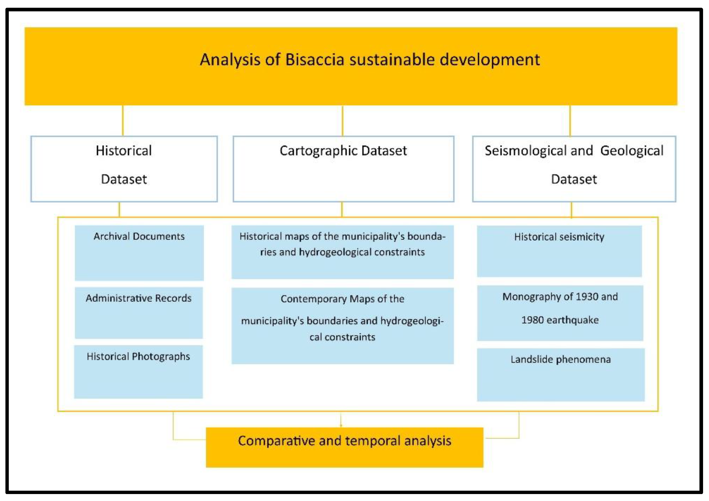
Figure 13.
Bisaccia (Avellino province): aseismic houses show in figs a, b, c date back to the post-earthquake period of 1930 and are still inhabited today (Photos from [35,55]).
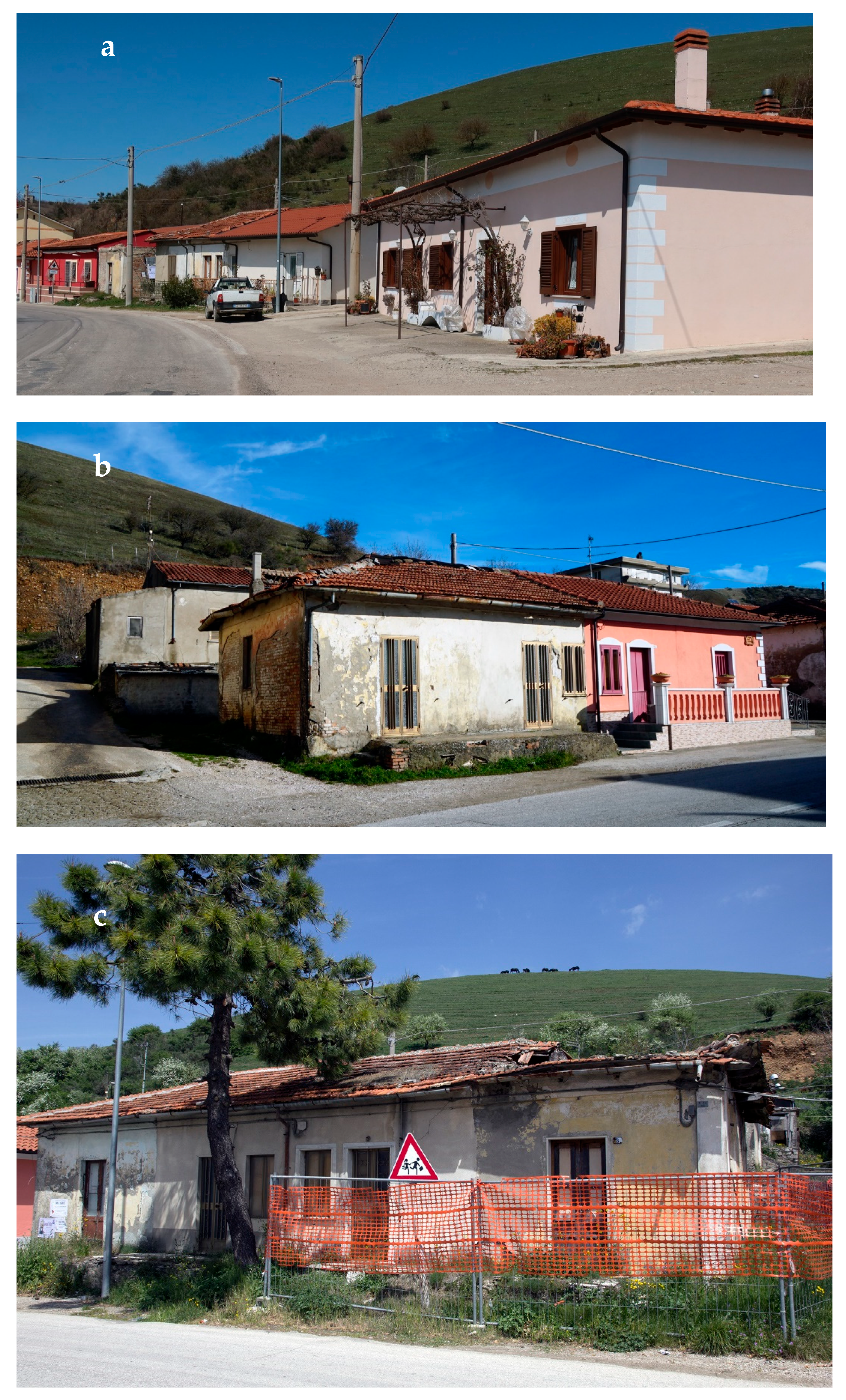
Figure 16.
The multi-functional centre designed by A. Loris Rossi for Bisaccia in the aftermath of the 1980 earthquake (a, b): example of a circular architecture (Photo from [24]).
Figure 16.
The multi-functional centre designed by A. Loris Rossi for Bisaccia in the aftermath of the 1980 earthquake (a, b): example of a circular architecture (Photo from [24]).
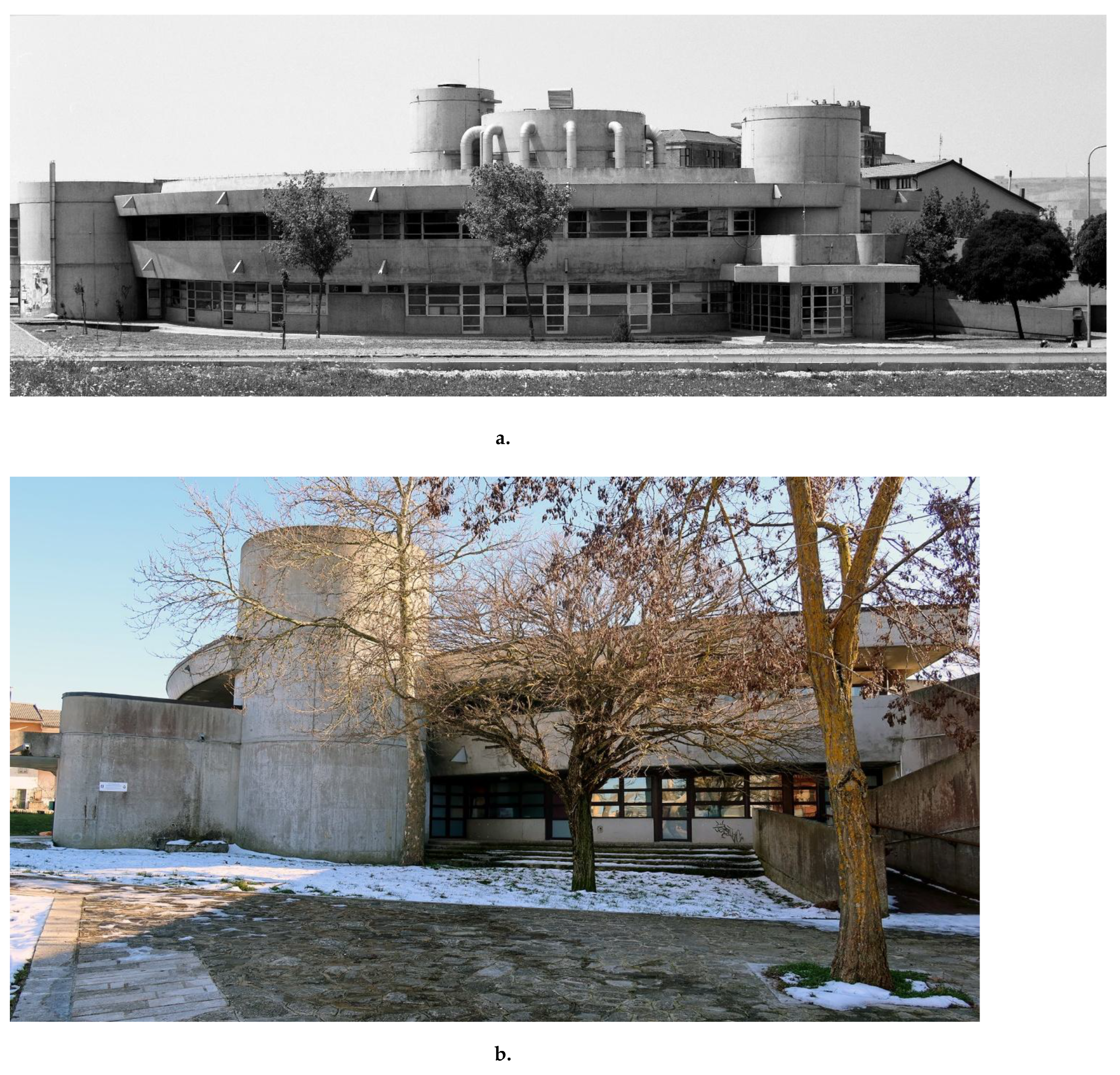
Figure 17.
Modern buildings constructed after the 1980 Irpinia-Basilicata earthquake. The urban layout of the new Bisaccia was designed by Aldo Loris Rossi (Photo from [24,35]).
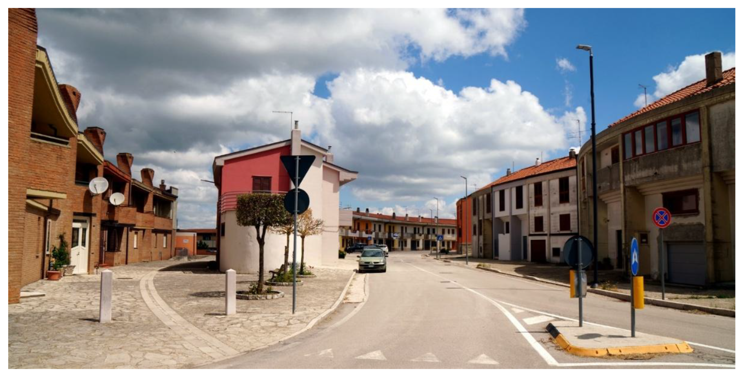
Figure 18.
The social houses (IACP) in Bisaccia were designed by Aldo Loris Rossi immediately after the 1980 earthquake. The demolition phase (Photo from [49]).
Figure 18.
The social houses (IACP) in Bisaccia were designed by Aldo Loris Rossi immediately after the 1980 earthquake. The demolition phase (Photo from [49]).
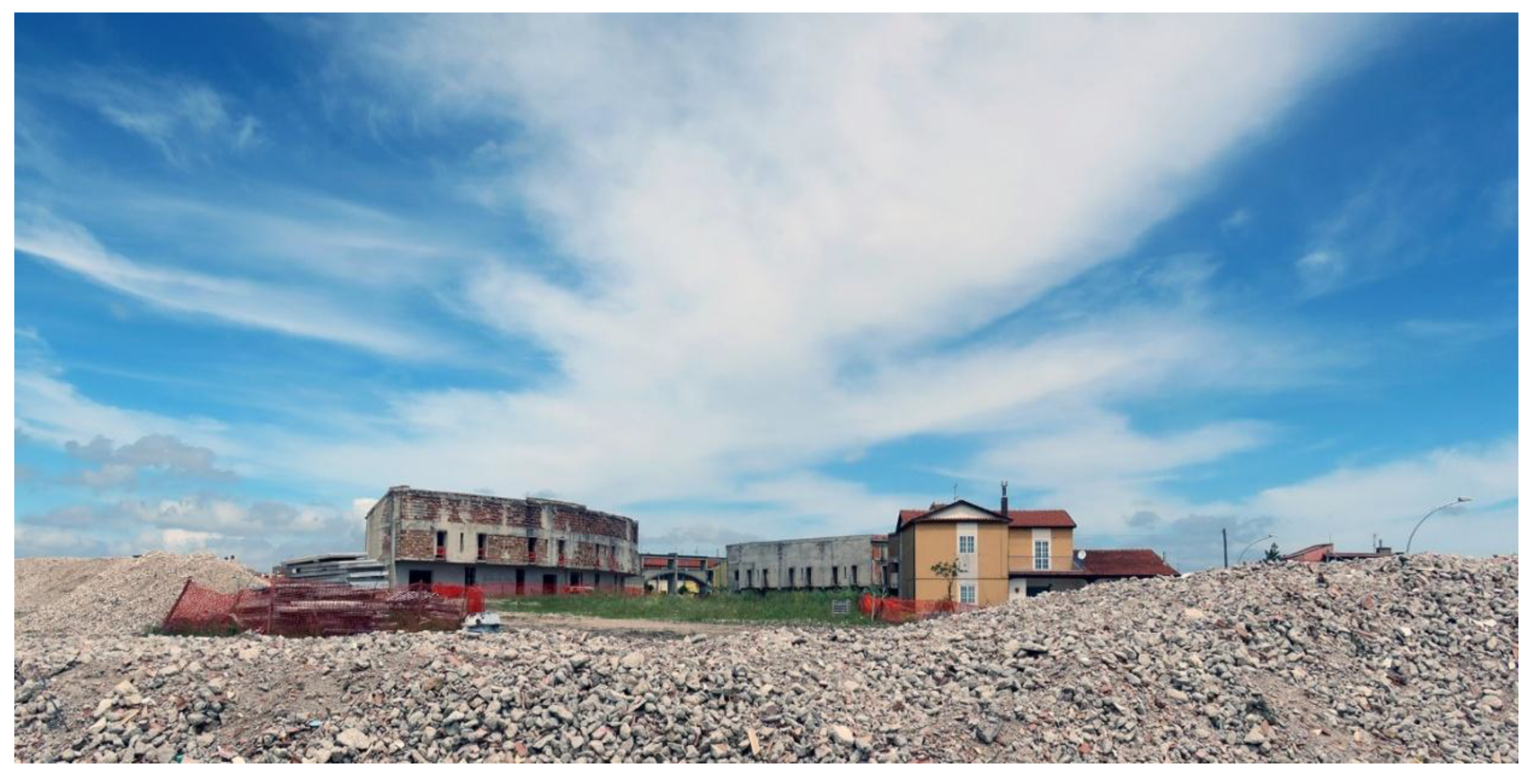
Figure 19.
The social houses (IACP) in Bisaccia were designed by Aldo Loris Rossi immediately after the 1980 earthquake. The reconstruction phase. (Photos from [49])
Figure 19.
The social houses (IACP) in Bisaccia were designed by Aldo Loris Rossi immediately after the 1980 earthquake. The reconstruction phase. (Photos from [49])
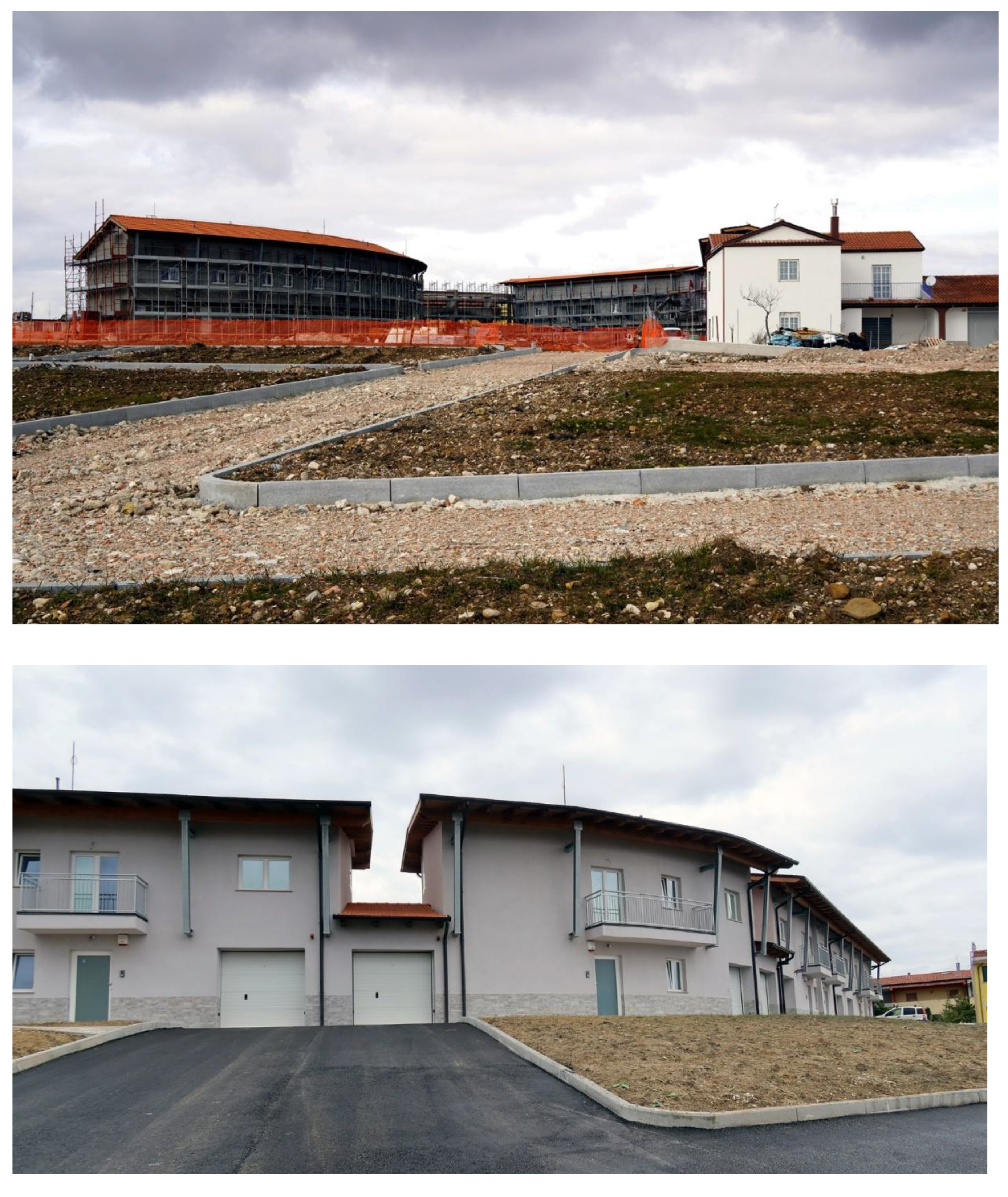
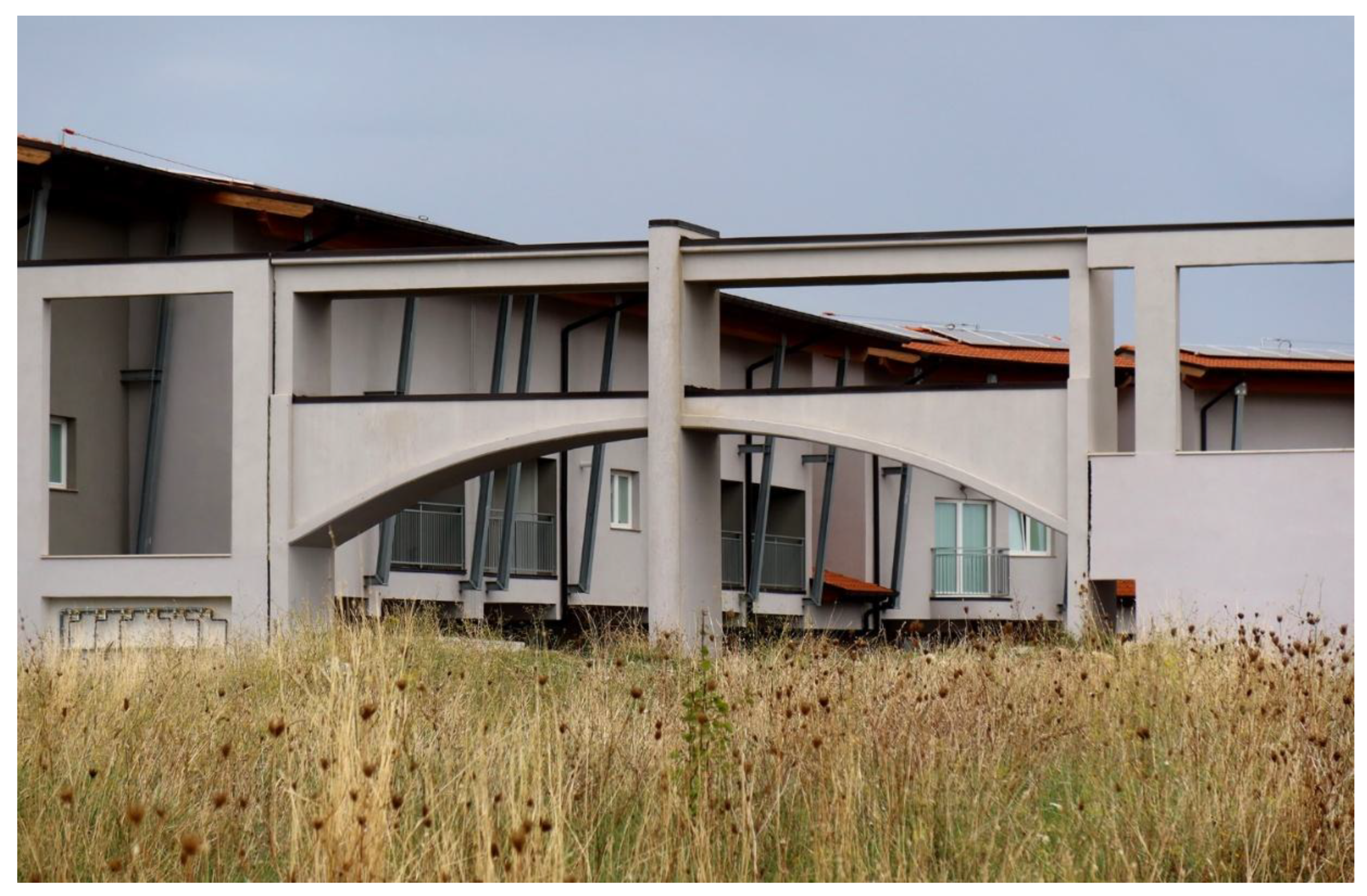
Figure 20.
Flowchart summarized the main phases of our study on the reconstruction of the town of Bisaccia.
Figure 20.
Flowchart summarized the main phases of our study on the reconstruction of the town of Bisaccia.
Disclaimer/Publisher’s Note: The statements, opinions and data contained in all publications are solely those of the individual author(s) and contributor(s) and not of MDPI and/or the editor(s). MDPI and/or the editor(s) disclaim responsibility for any injury to people or property resulting from any ideas, methods, instructions or products referred to in the content. |
© 2025 by the authors. Licensee MDPI, Basel, Switzerland. This article is an open access article distributed under the terms and conditions of the Creative Commons Attribution (CC BY) license (http://creativecommons.org/licenses/by/4.0/).
Copyright: This open access article is published under a Creative Commons CC BY 4.0 license, which permit the free download, distribution, and reuse, provided that the author and preprint are cited in any reuse.


