Submitted:
21 August 2025
Posted:
25 August 2025
You are already at the latest version
Abstract
Archaeological surface features on desert pavements, including geoglyphs, are notoriously difficult to assess. Absent temporally diagnostic artifacts they may be impossible to place chronologically, limiting their inferential utility. Whether they are cultural or natural in origin itself may sometimes be uncertain, not only again crippling their interpretative value but potentially creating problems for heritage management. Not surprisingly, a series of controversies have developed in the North American desert west over certain of these features. We describe methods for chronometrically constraining the ages of desert pavement features using three approaches to rock varnish dating: varnish lamination (VML) and lead-profile dating, as well as cation-ratio (CR) as an additional tool. Each of these techniques may be applied to rock varnished cobbles that have been upthrust into areas that have been previously cleared of the original pavement through cultural or natural processes. We apply these methods to three unresolved archaeological issues: the age of the intaglios (geoglyphs) along the lower Colorado River corridor; whether the Topock (or ‘Mystic’) Maze is the product of Precontact Indigenous or late nineteenth century railroad construction; and if commonly occurring cleared circles are natural features likely associated with now-missing vegetation and/or bioturbation, or were cultural products.
Keywords:
rock varnish
; chronometric dating
; intaglios
; geoglyphs
; historical linguistics
; Yuman speakers
1. Introduction
Surface archaeological features and sites are common if not ubiquitous in the North American Desert West. Despite their pervasiveness, these types of archaeological remains—lithic scatters, petroglyphs, rock alignments and cairns, and geoglyphs, cleared circles and trails in desert pavements—are problematic in the sense that their chronological placement is often unknown, limiting their inferential value. Indeed, in certain cases it is unclear whether specific features are human or natural in origin, complicating cultural heritage management (McDonald et al. 2011; Bullard et al. 2012). In select cases these features can be chronometrically dated, however, using rock varnish dating techniques. We describe and discuss these techniques and two issues in their application in the following. We then demonstrate the use of three techniques, and the inferential implications of the resulting chronometric ages, for three empirical case studies that help resolve long-existing archaeological controversies: the age of the intaglios (geoglyphs) along the Colorado River and thus the antiquity of the Yuman cultural pattern in this region; whether the so-called Topock (“Mystic”) Maze is a Precontact era Indigenous sacred site or instead a by-product of late nineteenth century railroad construction; and the age and origin of many cleared circles in desert pavements.
We start with a brief discussion of rock varnish itself before turning to the approaches and issues involved in its dating, concluding with our empirical studies and results and their implications.
1.1. Rock Varnish
Rock varnish is a paper-thin deposit that accumulates naturally on rock surfaces. It is composed of more than half clay minerals, about one-third Mn and Fe oxides, and minor and major trace elements (Dorn, 2024). Although it can form in any environment, rock varnish is most commonly recognized in arid regions (hence its non-technical label as ‘desert varnish’), where it typically appears in two forms: a chocolate brown to blue black varnish on exposed rock surfaces; and orange varnish found under ground-bands along the base of pavement rocks, as well as in cracks themselves (Dorn, 1998). Rock varnish dating involves the first of these two rock coatings, and is the focus of the following discussion and analyses.
The raw clay minerals that are transfixed to lithic surfaces forming a rock varnish coating are derived from windblown dust and thus vary based on regional geology (Dorn, 2025). Despite this variability, Mn-oxides typically dominate, commonly resulting in varnish’s dark appearance. The clay particles, Mn- and Fe-oxides and trace elements that comprise this coating are fixed to rock surfaces by biotic and abiotic processes, including the effects of budding bacteria (Chaddha et al., 2024; Dorn, 2024). Rock varnish is then an accumulated biogeochemical coating, not a patina formed from the chemical alteration of the underlying lithic surface, as it is sometimes incorrectly labeled.
Rock varnish’s development and its chemical constituents are also influenced by major paleoclimatic changes. During wetter periods varnish is Mn-enriched; drier periods instead result in a less Mn accumulation such that Fe dominates. Over time, as paleoclimatic conditions alternate, this results in a microstratigraphy of Mn- versus Fe-rich layers that is visible in ultrathin sections (Perry and Adams, 1978; Liu et al., 2025). These changes appear as contrasting color differences using optical microscopy, with black (Mn-rich), orange (Mn-low) and yellow (Mn-very low) layers (Figure 1). Varnish develops first in small pockets or micro-basins on a rock surface which, accordingly, typically preserve the most complete varnish layering sequence. This fact has important implications for rock varnish dating, discussed below.
It is important to note some additional caveats about varnish formation processes. First, multiple factors can impact or alter these processes and the preservation of complete layering sequences. Acid-producing lithobionts such as fungi (e.g., Burford et al., 2003; Favero et al., 2011; Favero and Viles, 2020), for example, may develop as climatic conditions change, or may be more prevalent in some environmental settings and their acids can dissolve rock varnish (Dorn, 2019, 2024). Second, this (and other factors) may result in an irregular distribution of potential varnish sampling micro-basins useful for archaeological dating, which in turn may impede systematic sampling (Whitley, 2013). Finally, there are other rock coatings that are Mn- and/or Fe-rich, including heavy metal skins, and case-hardened rock surfaces that incorporate varnish components (Dorn, 1998), that may be visually mistaken for rock varnish without technical analysis. All of these circumstances must be considered in archaeological applications of rock varnish dating.
2. Rock Varnish Dating Techniques
A series of different techniques have been developed and applied to rock varnish dating for archaeological purposes (Dorn, 1994, 2001), not all of which have been successful. We discuss three here that have been frequently used in recent archaeological applications: varnish microlamination (VML), cation-ratio (CR), and lead-profile, dating1.
It is important to emphasize that, regardless of chronometric approach employed, there is a time lag between the first exposure of a rock surface, such as the recently engraved groove of a petroglyph or the exposure of an upthrust cobble in an intaglio, and the initial development of a rock varnish coating. Although we provide new data relevant to this time lag below, here it is adequate to note that prior observations revealed that rock varnish starts to form in millimeter-sized rock-surface depressions, or micro-basins, in hot deserts within a century. We observed this at Fort Paiute in the Mojave Desert (Dorn et al., 1986; Bamforth and Dorn, 1988), on an intaglio made in the 20th century called the “Fisherman” (Dorn, 1998), discussed below, and on a 20th century engraving at South Mountain, Phoenix (Dorn et al., 2012). These prior findings do not indicate that an entire rock surface starts to revarnish within a century; it does not. The process starts in a few micro-basins initially and then slowly begins to cover other parts of a rock surface. As discussed below, this fact has implications for the use and efficacy of different varnish dating techniques and sampling strategies 2.
2.1. VML Dating
Perry and Adams (1978) first observed alternating Mn- and Fe-rich microstratigraphic layers in rock varnish thin-sections. These micron-scale laminations develop as a result of climatic changes (Liu and Broecker, 2007; Liu et al., 2025). The resulting layered patterning visible in an ultrathin section can be used to determine the age of the sample when compared to a regional sequence developed using independently-dated surfaces as calibration control points. VML dating is then conceptually analogous to tree ring dating, but it does not have the same chronological resolution as dendrochronology. When varnish grows slowly, as is mostly the case in hot deserts (Dorn, 1998), the temporal resolution is low and a sequence only records major climatic signals such as large glacial pulses. Where varnish grows more rapidly, as it does in moister microenvironments (Spilde et al., 2013; Dorn, 2024) such as a north versus south face of some boulders, however, roughly millennial-scale climatic events may be recorded throughout the Holocene (Liu and Broecker, 2007; Liu et al., 2025).
VML sampling requires the removal of a complete layering sequence from a rock varnished surface. This may be obtained mechanically, by carefully hand-prying off the varnish layer from a micro-basin using a tungsten needle, or by taking a hollow core sample which preserves the varnish sequence. It is necessary to obtain multiple micro-basin samples from the surface being dated to ensure that the most complete layering sequence is obtained. Sampling petroglyphs requires the removal of intact micro-basins from within the pecked-out area that defines the image whereas, for upthrust cobbles in cleared areas in desert pavements, they may be taken from anywhere on the exposed surface. We note that the area removed is typically a few millimeters in diameter.
Liu and Broecker (1999, 2007, 2008a, 2008b; Broecker and Liu, 2001) identified and calibrated a Late Pleistocene - Holocene Mojave VML sequence (Figure 1). This has been expanded into the lower Sonoran Desert with additional calibration points from radiocarbon-dated landslides (Dorn, 2014) and is used in this paper. Liu and Broecker (2007) further noted and Dorn (2014) verified that when varnish grows fast enough, WH1 is often subdivided into three layers (e.g. Figure 1A) formed in wetter phases of the Little Ice Age, at about 300, 500, and 650 calendar years before present. The chronological implications of this sequence have been described as follows:
“twelve wet event dark layers and thirteen dry event lighter layers … bracket the period from 300 yrs cal BP to 12,500 yrs cal BP. The lengths of the intervals between wet events vary from 250 to 1800 years, with an average of 970—roughly 1000 years. The resulting correlated VML ages are certainly not as precise as radiocarbon ages, but they are adequate for age assignment to the broad time periods comprising the regional cultural historical sequence” (Whitley, 2013:4).
VML, notably, has been subjected to, and verified by, blind testing using cosmogenically-dated geomorphic surfaces (Marston, 2003; Liu, 2003). VML has also been used to date artifacts, petroglyphs, constructed surface features, and geomorphic surfaces in Africa, the Middle East, and North and South America (Carbonelli and Collantes, 2019; Cerveny et al., 2006; Liu et al., 2021; Liu et al., 2025; Baied and Somonte, 2013; Whitley et al., 2017), even though its primary use has been in geomorphology (Liu and Broecker, 2008; Liu and Broecker, 2013). VML dating, for example, was used to predict that debris flows could be a major hazard in metropolitan Phoenix (Dorn, 2010), a prediction that was confirmed in 2014 (Dorn, 2016).
2.2. Lead-Profile Dating
The industrial revolution caused a significant increase in atmospheric pollutants, including lead (e.g., Candelone et al. 1995). One result is that rock varnish surfaces exhibit an observable increase, or spike, in lead (Pb), beyond the natural background levels in the rock coating. This lead spike occurs only in the very surface-most micrometers of rock varnish that accumulated in the 20th century. We identify the presence of lead in a VML sequence with an electron microprobe, using a focused micron-size beam for 200 seconds, which lowers the detection limit to 0.06% PbO (Dorn, 1998). This 20th century lead spike has subsequently and independently been verified in rock varnish as resulting from manganese and iron scavenging of lead (Fleisher et al., 1999; Hodge et al., 2005; Hoar et al., 2011; Nowinski et al., 2013; Spilde et al., 2013; Sims et al., 2022).
Lead-profile dating was first used to determine if the “Fisherman” intaglio near Quartzsite, Arizona, noted above, was pre-20th century in age or a more recent potential fake. As discussed below, rock varnish coatings from upthrust cobbles within this geoglyph were sampled, all of which were exclusively characterized by the lead spike, indicating a recent/20th century age for the creation of this surface feature (Dorn, 1998). Note that this does not preclude the possibility that this feature may be Indigenous in origin since the ritual practice involved in the use of these geoglyphs has continued into the twenty-first century (Whitley, 2014). That this intaglio is stylistically and thematically dissimilar from other examples, combined with its recent age, however, suggest that it may be Euro-American rather than Native American in origin.
Lead-profile dating has also been used to authenticate historical inscriptions (Dorn et al., 2012). An important use of this technique is the way we have employed it here: as the internal check it provides on the identification of the youngest Holocene rock varnish microlaminations at 300 (WH1a), 500 (WH1b), and 650 (WH1c) cal yr BP, correlated with three wet phases of the Little Ice Age (Liu and Broecker, 2007; Liu et al., 2025), as discussed above. Repeating a point noted previously, rock varnish dating is best conducted using multiple techniques (Dorn, 1994, 2001), as we employ lead-profile dating here.
2.3. CR Dating
The development of CR dating in the early 1980s (Dorn, 1983; Dorn and Oberlander, 1981) yielded the first calendrical age-constraints on petroglyphs (rock engravings), resulting in the first chronometric rock art ages (Dorn and Whitley, 1983, 1984). This technique is based on cation exchange processes in rock varnish that leach out mobile trace elements (K and Ca) more rapidly than stable elements (Ti) through capillary action (Dorn and Krinsley, 1991). The resulting rate of change can be calibrated using independently-dated control surfaces, such as river and lake terraces, and used to provide minimum-limiting age estimates for a rock varnish coating (Dorn et al., 1990).
While CR dating has been independently replicated in a number of regions globally (e.g., Pineda et al., 1990; Zhang et al., 1990; Plakht et al., 2000; Sarmast et al., 2017; Ntokos, 2021) and has been successfully subjected to blind tests in its archaeological use (Loendorf, 1991; Bamforth, 1997), it has certain analytical weaknesses. Varnish growth, as noted above, starts in micro-basins, with initial cation leaching then likewise beginning at discrete points rather than continuously and uniformly across a rock surface. This discontinuity requires the removal (though mechanical abrasion of varnish within the micro-basins) and chemical analysis of a bulk sample in order to obtain an average value for the coating as a whole (Dorn, 1994:24). The resulting age estimates often have large errors margins; and they can underestimate the true age of a varnish surface (see, e.g., Whitley, 2013: Table 1), despite efforts to exclusively sample within micro-basins and thereby minimize contamination from the younger portions of a varnish coating. The most important weakness of the technique, however, is its basis in biogeochemical processes which can potentially reverse over time. Despite these issues, a blind test matching CR to VML dating yielded comparable even if not fully equivalent results, demonstrating its value for broad-spectrum temporal analysis, such as identifying the age range of a corpus of petroglyphs, or a surface artifact assemblage. But like obsidian hydration dating, CR is not appropriate for confident age assignments for individual specimens (Whitley, 2013:7). Given the considerable advantages of VML discussed above, we employ CR dating below as a secondary check on the age assignment of a VML sequence.
2.4. Dating Surface Features in Desert Pavements
Dating surface features in desert pavements is based on the fact that the wetting and drying of fines and the accumulation of silt push buried cobbles upwards, onto the ground surface, in areas that have been previously cleared of these accumulative ground coverings (Springer, 1958; Haff and Werner, 1996; Adelsberger and Smith 2008; Adelsberger et al. 2013; Haff, 2014; Ugalde et al. 2020). When surface archaeological features involve the disturbance of the desert pavement (e.g., in the creation of a cleared circle, intaglio or trail), VML, CR and lead-profile dating can be used to provide a minimum-limiting age estimate on the subsequently upthrust lithic clasts, and thus on the creation of the archaeological feature. Two technical matters involved in dating desert pavements using such an approach warrant brief discussion here. These are the time lag involved in the upthrust of cobbles onto the surface in a disturbed desert pavement area, and the larger issue of the time lag in the initiation of varnish development on unvarnished rock surfaces of all kinds, noted briefly above.
2.4.1. Time Lag in Desert Pavement Regeneration
A variety of observers have claimed that desert pavement regeneration begins within a few months to a few years (Péwé, 1978; Haff and Werner, 1996; Dietze and Kleber, 2012). We monitored the rate of pavement reformation in meter-scale disturbance plots created by Troy Péwé in the Sonoran Desert outside of Mesa and Quartzsite, Arizona (Péwé, 1978; Bales and Pewe, 1979), to test these estimates, for over four decades. We continued monitoring these pavements with Péwé’s permission, even after his passing in 1999.
It was important for our purposes to consider only those cobbles that emerged from the subsurface after Péwé cleared these sample plots, and to ensure that any sampled cobbles were not remnants of the original pavement nor were inherited contaminants, through disturbances of some kind from the surrounding areas. We focused, accordingly, only on those cobbles with inclusions of millimeter-scale fragments of pedogenic carbonate. Such carbonate coatings develop on buried clasts (Springer, 1958; McAuliffe and McDonald, 2006; Haff, 2014), and precipitation would dissolve the carbonate once exposed on the ground surface after a few decades, allowing us to eliminate the possibility that our sampled cobbles were remnants of or derived from the original pavement surface. We found that it took 14 years at the Mesa site and 22 years at the Quartzsite site for previously buried cobbles to emerge and start reforming a new desert pavement. The implication is that desert pavements begin to regenerate within a few decades of disturbances to them, indicating that rock varnish dating of subsequently upthrust clasts can provide an archaeologically-reasonable minimum estimate of the age of manufacture of these types of surface features.
We stress that pavement generation and its regeneration is an ongoing process. The length of time it takes to form a completely intact pavement, measured by radiocarbon and optically stimulated luminescence, can range from about 5000-6000 years in the Mojave Desert to about 12,000 years in Death Valley, California, when cobble sizes are under about 10 centimeters (Seong et al., 2016). The samples we collected are thus from pavements that are still regenerating and tend to have even smaller cobble sizes. We emphasize that the varnish ages presented here are minimum estimates for the age of a pavement disturbing event.
2.4.2. Time Lag in Initiation of Revarnishing
It is also important to emphasize that, regardless of chronometric approach employed, there is a time lag between the first exposure of a rock surface, such as the newly engraved groove of a petroglyph or an upthrust cobble, and the initial development of a rock varnish coating: the start of its revarnishing for petroglyphs and the initiation of varnishing on upthrust cobbles. As noted above, prior observations revealed that rock varnish is present in millimeter-sized rock-surface depressions, or micro-basins, in hot deserts within about a century, but the varnish only slowly begins to cover other parts of an exposed rock surface. Varnish age across a surface then varies from point to point, a fact which is critical in terms of effective chronometric sampling.
We used the opportunity afforded by the pavement regeneration study, discussed above, to improve the understanding of this time lag in the start of surface revarnishing. Although rock varnish was not detectable on most of the previously buried cobbles we observed on the ground surface at Péwé’s Mesa study locale, two had started to develop a varnish coating after 19 years of surface exposure. These coatings, however, were only visible using electron microscopy (Figure 2), not with the light microscopy used for VML and, as expected, were restricted to micro-depressions on the cobble surfaces.
We further assessed the revarnishing time lag using a natural petroglyph-like feature — a 0.5 cm-wide scar on a rock surface, created by a landslide in the McDowell Mountains, Scottsdale, Arizona. A radiocarbon age of 1180-1290 cal year BP, obtained on a crushed paloverde tree under the landslide feature (Dorn 2014), provides a useful age constraint on the natural event that created this scar. This allowed us to assess the variability of rock varnish ages in different micro-basins within this feature, using VML dating, along with the rate and degree to which rock varnish spread across this groove, using X-ray mapping (Friel and Lyman, 2006).
Only two of 10 VML cross-sections from micro-basins in the scar had the WH2 microlamination, thereby matching the radiocarbon age. The remainder provided younger estimates: four had the WH1 (Little Ice Age) microlamination at their base, and four were post Little Ice Age (younger than 300 cal yr BP). We accordingly only use the oldest VML sequence for each feature in our age estimates, because the oldest VML provides the smallest time lag between cobble exposure and the onset of varnishing and is likely closest to the true age of the feature. These results emphasize, again, that varnish dating techniques provide minimum-limiting age constraints rather than ‘absolute dates,’ as well as the need to sample multiple micro-basins to obtain the most accurate age.
3. Age of the Colorado River Intaglios
Substantial popular interest has developed over the last half century in the intaglios (geoglyphs or earth figures) found on the terraces along the lower Colorado River in California and Arizona. These commonly include very large (tens of meters in maximum dimension) stick-like human figures, rarer depictions of animals (mountain lions, lizards, snakes), and geometric patterns like spirals and zigzags, often associated with cleared paths and circles (Figure 3). Like the more famous Nazca Line intaglios of Peru, much of this popular appeal involves spurious claims about putative associations with ancient aliens when, in fact, there is Native American ethnography on the meaning and ritual use of these surface features (Bourke 1889; von Werlhof, 2004; Whitley 2014, 2023). This demonstrates that the sites are specific locations of mythic events for the River Yuman-speaking Quechan and Mojave; that the motifs portray the actors and events that occurred at each location; and that the sites were—and at least until two decades ago continued to be—used for ritual pilgrimages undertaken to re-experience the creation of the world. They are somewhat then akin to the commemorative and ceremonial purposes of the Catholic Stations of the Cross, on a landscape scale.
While there is widespread professional archaeological acknowledgement of the Indigenous ritual origin of these surface features, their age has been uncertain, as has the potential antiquity of the associated pilgrimage and ritual belief systems tied to them. This is important in part because the history of Yuman-speaking peoples in this region is uncertain. There is an archaeological consensus that Yuman-speakers were present along the river corridor by at least 700 CE (Schroeder 1979), based on the development of the Hakatayan/Patayan archaeological “culture,” but their initial arrival in this region is unresolved. Many archaeologists suggest a relatively late River Yuman arrival (e.g., von Werlhof 1995; Laylander 2001, 2010, 2015). Linguistic evidence, however, alternatively suggests that they may have been present much earlier (Hinton 1991; Field 2018), especially if the Colorado River Delta and/or Colorado Desert area is the homeland for the Proto-Yuman language, as Mixco (2006) and others (Law 1961) have hypothesized.
3.1. VML and CR Ages on Intaglios
Table 1 presents a compilation of rock varnish minimum-limiting ages for intaglios on both sides of the lower Colorado River, along with a trail associated with the Ripley site, including new VML, CR ages and lead-profile ages. Included in the table are calibrated CR ages from a prior study (von Werlhof et al., 1995) 3 in addition to the new chronometric estimates. The VML ages represent the oldest microstratigraphic sequence observed from 10 cobbles analyzed from inside of each of these features. Control cobbles from the unaltered desert pavement surrounding each feature were also analyzed. These “controls” were all Late Pleistocene in age.

Table 1.
Minimum rock varnish ages for intaglios (and an associated trail) obtained in this and prior research, as explained in the text, using three different rock methods. The CR ages without matching VML ages have been calibrated from raw data presented in von Werlhof et al. (1995).
Table 1.
Minimum rock varnish ages for intaglios (and an associated trail) obtained in this and prior research, as explained in the text, using three different rock methods. The CR ages without matching VML ages have been calibrated from raw data presented in von Werlhof et al. (1995).
| Intaglio, Site | VML age cal yr BP |
CR age cal yr BP |
Lead Profile |
| Zigzag/Snake, Quien Sabe | 650 | 500 ± 300 | Pre-20th century |
| Stick Figure, Winterhaven | n/a | 750 ± 300 | n/a |
| Anthropomorph, Pilot Knob | n/a | 850 ± 350 | n/a |
| Anthropomorph 1, Blythe Giant | n/a | 1000 ± 350 | n/a |
| Quadruped, Blythe Giant | n/a | 1100 ± 400 | n/a |
| Anthropomorph 2, Blythe Giant | n/a | 1100 ± 400 | n/a |
| Anthropomorph, Ripley Complex | between 1100-1400 | 1200 ± 450 | Pre-20th century |
| Cross, Ripley Complex | between 1100-1400 | 1250 ± 450 | Pre-20th century |
| Largest Anthropomorph, Quartszite | n/a | 1350 ± 350 | n/a |
| Amorphous Form, Quartszite Airport | n/a | 1400 ± 400 | n/a |
| Anthropomorph, Quien Sabe | 1400 | 1500 ± 450 | n/a |
| Trail, Oatman | 1400 | 1500 ± 500 | n/a |
| Lizard Figure, Ripley | n/a | 1600 ± 500 | n/a |
| ‘Snake’ Head, Singer Complex | n/a | 1900 ± 550 | n/a |
| ‘Snake’, Museum complex near Ocotillo | n/a | 2900 ± 750 | n/a |
| Schneider Dance Circle, Yuha Mesa | n/a | 3200 ± 750 | n/a |
| Anthropomorph, Quien Sabe | 5900 | 6100 ± 1200 | n/a |
The minimum-limiting age estimates range from 650 to 5900 cal yr BP, or from the Late Precontact period to the middle Holocene. Figure 4 presents the oldest of the observed VML sequences for two intaglios from the Ripley Complex, Arizona, perhaps the largest intaglio site along the Colorado River. An orange layer underneath the black WH2 layer is shown in Figure 4A, indicating that its varnish began to develop between WH2 and WH3, or from 1100 to 1400 cal yr BP. Figure 4B displays only a very small section of the orange laminae, with the black WH2 layer as its basal layer. Since varnishing always post-dates exposure of a pavement clast, and since upthrust cobble exposure itself takes time, an appropriate minimum age assignment would be 1100 to 1400 cal yr BP for both intaglios.
Note that an area labeled “bacteria cast” in Figure 4A is a cluster of budding bacteria with their cellular casts encrusted in Mn and Fe. These casts are normally dissolved and remobilized as varnish grows (cf. Dorn, 2024), but some preserved areas may occur where varnish is particularly fast growing. This is consistent with preservation of the three Little Ice Age wet events, present in both profiles and indicative of relatively quick varnish development. Lead-profile dating is also consistent with these analyses, as are the CR ages.
That both Ripley intaglio VML ages fall within the same time range suggests that the two geoglyphs may have been created in the same event, or at least during the same general time period. This possibility is enhanced by the CR ages from the famous Blythe Giants site, all three of which are internally consistent with average dates of 1000 - 1100 cal yr BP. This perhaps indicates that at least some of these sites were planned compositions rather than accretions of motifs added over time. Note further that there seems to be a cluster of dates roughly occurring in the first millennium of the Common Era, when the CR dates on samples without accompanying VML ages are included. This may represent a period of intensified ritual activity.
The Quien Sabe Point site, however, presents a very different picture. Figure 5 shows three previously undated geoglyphs from this locale. Ages indicated by the oldest VML sequence from each of the sampled intaglios are presented in Figure 6. These range from 650 to 5900 cal yr BP, which are corroborated by the CR estimates, suggesting that new intaglios were added to this site over a very long period. This demonstrates both the long-term continuity in the use of a specific location for rituals, as has been documented in other Native American cases (e.g., Sundstrom 1996; Whitley et al. 1999), as well as change over time in the sense that new motifs were successively added to the markers signaling this location as sacred. This last fact counters any claim that the intaglio ritual tradition was somehow ahistorical—that is, unchanging—given that it involved the addition of new symbolic elements and, as indicated by the results from the Blythe Giants and Ripley sites, additional sites/ritual locations, over time.
We emphasize, again, that the oldest VML and associated CR ages for each intaglio are the most appropriate estimates, because all varnish dates are minimum-limiting dates. This is due to time lags in pavement reformation and in varnishing. The 5900 cal yr BP age for one of the Quien Sabe anthropomorphs relative to the other two dates, however, raises an obvious question of reliability. This early date is supported by the VML age distribution of the other nine sampled cobbles from this specific intaglio. Two of these have the same WH6 sequence (5900 cal yr BP) age; five have the WH3 sequence (1400 cal yr BP); and two have WH1c at their base (650 cal yr BP). The VML age distribution for these ten sampled cobbles from a single intaglio could reflect ongoing pavement reformation processes, ongoing lag in varnishing, or some combination of these processes. The age distribution might also reflect imperfect “upkeep” (that is, periodic clearing of newly upthrust cobbles in the intaglio), since we know that, in a relevant parallel case, ritual initiates were required to maintain the Trail of Dreams by tamping down this trail used in their puberty rites with logs (Whitley 2014). Since the VML age of the adjacent pavement control cobbles is at least 36 ka, we are confident that WH6 (5900 cal yr BP) is an accurate minimum age assignment for the oldest of the intaglios, and not an result of contamination from the surrounding pavement.
The results from the Singer Complex (Figure 7) warrant brief discussion. This site is located in an area where armored infantry troops trained during World War II, west of the river corridor, and pavement disturbance from tanks is visible in the immediate site area. This has led to questions about the authenticity of this site: are the geoglyphs Indigenous in origin or instead the result of military activities of some kind (cf. Casey 1992)? This last possibility might seem supported by the site’s location, some distance from where most other intaglio sites occur, and due to the relatively unique nature of its intaglios: very long, snake-like forms. The 1900 cal yr BP resolves that question, demonstrating that these intaglios long pre-date Euro-American arrival in North America.
We also include in these data a VML age for a trail associated with the Oatman site, on the Gila River, Arizona, because of both its substantive and methodological implications. The archaeological significance is that the trail leads to several intaglios, and its age is likely therefore related to ritual activities at these geoglyphs. Sampling, however, specifically involved a cluster of broken crystalline quartz in the reforming trail pavement. The bottom VML layer for the sampled quartz is WH3, indicating an age of 1400 cal yr BP (Figure 8A). As described elsewhere (Whitley et al. 1999), quartz was broken up by shamans during vision quests to release, and therefore acquire, its inherent supernatural power, which was visibly manifest in the triboluminescent glow that resulted. This suggests that this practice may have at least sometimes occurred during visits to the intaglios.
The methodological issue relates to lag times of varnishing on surfaces. While the best minimum age for the trail is 1400 cal yr BP, eight other cobbles were younger than the Little Ice Age, or younger than 300 cal year BP. The back-scattered electron micrograph shown in Figure 8B illustrates why there are so many “younger” ages: the small bright spots are locations of varnishing in microdepressions. This image is a typical example of common Holocene varnish development. The tiny micron-scale pockets are where varnishing first starts to develop, and it is in these pockets where sampling and images are obtained and the oldest varnishing can be visually identified for VML dating. CR dating samples these pockets separately and integrates all the varnish in a sample for the cobble and this integration is one reason why the error term is so high.
3.2. Implications of the Intaglio Ages
There are two issues concerning our intaglio rock varnish ages, ranging from 650 to almost 6000 years ago, that warrant discussion. The first is methodological. It concerns the fact that dating desert pavements is predicated on the processes which re-generate these surfaces over time, as new cobbles are upthrust into a cleared surface. The important question then is how an intaglio can persist for as long as 6,000 years, given that much younger archaeological features may be buried under desert pavements as they re-form (e.g., Ahlstrom and Roberts 2001)? The likely explanation, as noted above, is that these geoglyphs were actively even if not perfectly maintained, keeping them (mostly) clear of newly upthrust cobbles over the millennia. Ethnographic evidence indicates that the cleared surface of so-called Trail of Dreams, which runs through desert pavement and was used for the Quechan boys’ puberty initiation run, was tamped down periodically by the boys, using logs, so it would be cobble free (Whitley 2014). It is likely that a similar practice existed for the intaglios themselves and that this accounts for their persistence.
The second issue is substantive and it involves the relationship of the intaglio tradition to the origins of River Yuman-speaking peoples (Mohave, Quechan and, historically, Halchidoma) along the lower Colorado River corridor (von Werlhof 1995). It is important to emphasize at the outset that there is no perfect correlation between language, culture and physical-biological (“racial”) type, as the first half-century of Boasian anthropological research demonstrated conclusively (Whitley 2019, 2021). But the parallel fact is that we cannot reduce a culture to an adaptive system or artifact assemblage. Cultures instead are defined in contemporary anthropological terms as cognitive systems of shared symbols and meanings, often tied to common ritual and belief systems, not sets of norms, artifact assemblages or types, nor adaptive strategies, as many archaeologists still assume (Whitley 1992, 2020, 2024). As Sahlins (1985) has emphasized, furthermore, different aspects of human social life change at different rates, with technological and economic factors shifting quickly while belief and ideological systems—which is to say cultures—are much slower to change. Indeed, as Steward noted, a half-century of acculturation among nearby Numic speakers:
“has not wiped out all Indian practices. Acculturation has consisted primarily of modifications of those patterns necessary to adjust to rural white culture … The Shoshoni retain, however, many practices and beliefs pertaining to kinship relations, child-rearing, shamanism, supernatural power and magic” (1955:58).
Religion, a set of beliefs and practices involving supernatural agents, is often but not always a proxy for culture. While this is not the case for large scale societies, like our contemporary western world with its proselytizing religions (Keane 2003), full concordance often exists between the cultures of small-scale societies, like those in the North American desert west, and their non-proselytizing religions (e.g., Harris 1940:55; Opler 1940:136; Siskin 1983:11; Laird 1976:24). Religious remains, including sacred objects and evidence of ritual practices, are then the most useful category of archaeological remains for studying cultural continuity and change. Even if we cannot, with complete certainty, equate culture with language, genetics or phenotypes alone, an assumed equivalence is reasonable in certain cases. A series of matters concerning the linguistic history of the Yuman-Cochimi language family then warrant discussion in light of our chronometric ages and their possible importance as an expression of an early Yuman-speakers’ cultural system along the lower Colorado River.
These start with the fact that many linguists hold that the Baja California peninsula was a linguistic dead-end in terms of the initial Late Pleistocene migration and colonization of the west coast, resulting in the development of an isolated speech community in this restricted area that eventually developed into the ancestral Yuman-Cochimi languages. This standard reconstruction posits that this initial colonization was followed by successive migrations northwards, out of this cul-de-sac homeland, creating a kind of linguistic stratigraphy, as it is sometimes described (Shaul 2020; cf. Massey 1961, 1966; Kowta 1984; von Werlhof 1995). But this reconstruction entails at least one confounding empirical problem. This is the 200 kilometers separation between the Pai-speaking branch at the northern extreme of the Yuman languages, with the Iipay and Tiipay (“Diegueño”) in the coastal San Diego area and the Yavapai, Walapai and Havasupai (“Upland Yumans”) in central- and north- western Arizona. This is typically, though not plausibly, explained by a very late, hypothesized migration and thus split of Pai speakers in one direction or the other (e.g., Laylander 2015).
A more parsimonious reconstruction would suggest instead that there was an extra-peninsular Proto-Yuman heartland in southern California and/or the Colorado River Delta region, as Mixco (2006) argues, based on linguistic borrowing and reconstructed ecological terms. The separation over time into distinct speech communities and, ultimately, individual Yuman languages occurred at least partly in-situ, then, rather than primarily due to migrations. The geographical separation of the Pai, further, resulted again in part or wholly from the later movement of Takic-speakers southwards into former Yuman territory, as Hinton (1991) first suggested, splitting the Pai apart, rather than exclusively due to late-dating Pai migrations. This last possibility accommodates the physical anthropological evidence suggesting that the Cupan branch (Gabrielino, Luiseño, Cupeño and Cahuilla) of Takic-speakers were originally biologically-Yuman or, alternatively, that a substantial proportion of Yuman speakers were absorbed into the in-moving Takic to account for the physical similarities (summarized by Sutton 2009), as well as the equivalences in their mythic corpora (cf. Kroeber 1906; Waterman 1909). It also fits with the genetic evidence (Monroe et al. 2013) and comparative trait studies (Jorgensen 1980) which suggest an earlier split for the Pai languages. Relatively greater antiquity, rather than recent arrival, then is a plausible even if unproven expectation for the Yuman speakers along the lower Colorado River, suggesting that the early dated intaglio in fact may reflect the presence of these peoples 6,000 or more years ago.
The subtexts of this first point are estimates for the various divergences in the Yuman-Cochimi and surrounding language families, the second pertinent issue concerning the linguistic history of this region and its relevance to early intaglio dates. Three general approaches to the history of these languages have been employed in the far west, an understanding of which is necessary for clarifying their value to archaeological interpretation, as well as reconstructing the cultural history of Yuman-speakers along the river corridor. The most common of these approaches involves linguists’ guesstimates commonly offered, insofar as we have been able to determine, with little or no detailed analytical basis, but apparently based on very general analogies (e.g., Golla 2007). These guestimates appear tied to the following assumptions:
“The rule of thumb (derived from the study of languages with hundreds of years of written documentation…) is that after about 2,000 years, language changes tend to have obscured the clear sorts of correspondences [for grouping language families and detecting borrowing, while] … After 5,000 years there are few [such] correspondences” (Shaul 2014:7).
The implications are that (1) all languages change at approximately the same speed, universally, regardless of population size and density, interaction networks, communication transmission and storage systems, demographic structure or social complexity; and that (2) the written texts of the Indo-European, Egyptian and Semitic language families, the source of these estimates, are appropriate analogical models for the rate of linguistic changes, even to all manner of small-scale oral cultures and societies. Since language divergence and change is at least partly based on (if not heavily influenced by) the social structure of the speech communities using a given tongue, the nature of their interactions with speakers of surrounding languages (cf. Babel et al. 2013), and the differences in the various types of population movement and replacement that may occur (cf. Eshleman et a. 2004; Kemp et al. 2010), these assumptions are empirically implausible from the start (cf. Greenhill et al. 2023:85).
But even more severe, from an archaeological perspective, is the temporal limit that such assumptions necessarily impose on the past, with the observable linguistic differences then required to have developed solely in the last few thousand years. Taken at face value and in aggregate, a synthesis of the far western Precontact past using these guestimates would require numerous and frequent in- and out- migrations of different peoples, as if the far west were little more than a transit corridor for population displacements. Only occasionally is there a logic suggested that (right or wrong) would explain the cause for such movements (Bettinger and Baumhoff 1982, Diamond and Bellwood 2003, and Sutton 2009 are some notable exceptions). Even more rarely is there a plausible description offered concerning where those populations that were forced-out or replaced moved to, and the larger downstream demographic ripple effects of these geographical shifts. The effective result is models of linguistic change without people involved or social interactions considered. The similarities and close relationships between many far western Native American languages, instead, are more likely a reflection of “a normal foraging adaptation in an arid region” (Shaul 2014:66) resulting from a linguistic network rather than a dialectical chain, as opposed to numerous, necessarily recent population movements, as the guestimates require.
A second, superficially more analytical approach to linguistic history has employed glottochronology. This has suggested that the core Yuman languages split up between 3,500 and 1,300 YBP (Shaul and Hill 1998). Note however that Shaul (2014) is no longer willing to assign specific dates to linguistic divergences, tacitly questioning his previously-published estimate. This change in perception reflects a more widespread rejection of glottochronology, the nature and usefulness of which is well-described as follows:
“Glottochronology uses the percentage of shared ‘cognates’ between languages to calculate divergence times by assuming a constant rate of lexical replacement or ‘glottoclock’. Cognates are words inferred to have a common historical origin because of systematic sound correspondences and clear similarities in form and meaning. Despite some initial enthusiasm, the method has been heavily criticised and is now largely discredited. Criticisms of glottochronology, and distance-based [statistical] methods in general, tend to fall into four main categories: first, by summarizing cognate data into percentage scores, much of the information in the discrete character data is lost, greatly reducing the power of the method to reconstruct evolutionary history accurately; second, the clustering methods employed tend to produce inaccurate trees when lineages evolve at different rates, grouping together languages that evolve slowly rather than languages that share a recent common ancestor; third, substantial borrowing of lexical items between languages makes tree-based methods inappropriate; and fourth, the assumption of a strict glottoclock rarely holds, making date estimates unreliable. For these reasons historical linguists have generally abandoned efforts to estimate absolute ages” (Gray and Atkinson 2003:435-436).
The disqualifying problems inherent to glottochronological analysis are further emphasized by the fact that language changes sometimes involve punctuated bursts rather than gradual, progressive evolution (Atkinson et al. 2008), as glottochronology would require.
The third approach to linguistic history is the use of computational phylogenetic models derived from evolutionary biology. These overcome the four main problems with glottochronology and they employ linguistic, genetic and archaeological data to calculate dates for language change, with the archaeological and genetic data calibrating the linguistic rates. Although this approach has not yet been applied to the Yuman-Cochimi languages, to our knowledge, Greenhill et al. (2023) have provided an analysis of the neighboring Uto-Aztecan language family which has implications for the Yuman-Cochimi problem: the temporal relationship of the Yuman speakers to the neighboring Takic branch of Uto-Aztecan speakers and their residence in southern California. There is widespread agreement that the Yuman peoples were in place to the north of the Baja peninsula earlier than the Takic (e.g., Hinton, 1991; Elliot 1994; Sutton 2009; Shaul 2014; Field 2018). Initially the arrival of the Takic in California was widely assumed to be linked to a southern origin, and intrusive migration northwards of Uto-Aztecan speakers out of Mexico, perhaps associated with the spread of maize agriculture (e.g., Hill 2001). This necessarily placed Uto-Aztecan speakers in the region relatively late and, by implication, also then accommodated a relatively younger date for the presence Yuman speakers. The alternative hypothesis was a northern origin for Uto-Aztecan speakers as a whole, including the Takic branch (Fowler 1983). Although this was initially a minority opinion, recent phylogentically-based reevaluations of Proto-Uto-Aztecan linguistic history provide significant support for the northern origin hypothesis, as well as deeper time-depth for these people in the region (Merrill 2012; Greenhill et al. 20234). The Proto-Uto-Aztecan language had differentiated into its own distinctive speech community minimally by about 4,000 years ago, based on these latest reconstructions, in the central Mojave Desert adjacent to the Colorado River corridor. Assuming this reconstruction is correct, Yuman speakers necessarily then would have been in place outside of the Baja peninsula prior to about 4,000 years ago.
[Footnote 4 – The archaeological data that Greenhill et al. used in their analyses
were from reports that partly based their chronologies on the discredited Lamb (1958) glottochronological study of the Numic branch of Uto-Aztecan, potentially biasing the phylogenetic results towards a younger estimated date. This was pointed out in personal correspondence with Simon Greenhill who kindly re-ran his analyses with those data removed. This yielded no appreciable difference in the results and thus his estimated 4,000 YBP date for the development of Proto-Uto-Aztecan in the Mojave Desert (email communication to Whitley, 7/18/2024). Unanswered, however, is a related question: what effect would the inclusion of earlier archaeological ages based on evidence suggesting much longer-term Numic cultural continuity, extending back into the Terminal Pleistocene (Whitley 2013; Whitley et al. 1999), have on the calculated estimate for Proto-Uto-Aztecan in the region?]
There is then a plausible even if not conclusive argument suggesting that the 6,000 years antiquity of the intaglios reflects an early and, ultimately, enduring River Yuman religious and ritual system. This would comprise a third long-lived North American rock art tradition, joining the Great Basin petroglyphs (Whitley 2013, 2019; Whitley et al. 1999) and the Pecos River pictographs (Steelman et al. 2025), each of which also lasted for thousands of years. The three traditions provide a stark contrast to the changes in subsistence strategies and artifact assemblages over the same time periods in these three respective regions. This points on the one hand to the poverty of adaptive patterns and tool-making practices for understanding the cognitive and religious lives in Precontact Native America. But it does not, on the other, imply that these traditions were necessarily timeless and ahistorical, as is sometimes alleged. Such criticisms are based on confusions about the nature of religious change, in that they assume that historical changes necessarily require catastrophic breaks or massive shifts in practice and belief. As Bloch (1986, 1992) has illustrated, religious change over time often instead may involve a persistent core of ritual practice that alternately is elaborated and embellished, followed by a retrenchment to the basic pattern. Just such a pattern of change, in fact, can be cited for the desert west, where the historical Ghost Dance developed out of traditional Paiute and Shoshone beliefs. With the failure of its prophecies, however, Basin religion returned to its core of traditional beliefs and practices (Jorgensen 1986). There is justification in assuming that similar processes of religious expansion and retraction, in other words, may have occurred along the Colorado River, contributing to persistence yet also variability over time.
4. Age and Origin of the Topock Maze
Few surface rock features are visually more impressive, and more controversial, than the Topock (or ‘Mystic’) Maze geoglyph site (CA-SBR-219). Located on adjacent Colorado River terraces near Needles, California, the site consists of an extensive series of low, linear gravel rows that have been scraped into the desert pavement, creating numerous parallel cleared paths, each about 1.3-meters wide (Figure 9 and Figure 10; despite the name, these cleared paths do not form an actual maze). The site area has been heavily impacted by over a century of development, starting with the Atlantic and Pacific Railroad right-of-way through the site in 1893. The subsequent construction of Interstate-40 and the railroad grade now divide the locality into northern and southern areas. The southern section is bounded by a PG&E pipeline compression station and county waste-water treatment plant on the east and west, respectfully, with steep terrain to the south; while the northern portion has been impacted by a variety of projects, including the construction of a marina along the river. Extant sections of the gravel alignments today cover about 13 hectares (34 acres), while the remnants suggest that it may have originally been very roughly 100+ hectares (247 acres) in size. The site was listed on the National Register of Historic Places (NRHP) in 1978, signaling its importance as a heritage resource.
Controversy over the origin and function of the site has long existed (see Haenszel 1978; Musser-Lopez 2011), however, despite its NRHP listing, with some contending that the site resulted from the collection of gravel for railroad track ballast. This argument has been putatively supported by an early article describing construction techniques for the 1893 Red Rock Bridge, which crosses the Colorado River at this location. This states in part that, for construction purposes:
The process of gathering [gravel] was to rake these fragments of [surface] stone into windrows and haul them by wagon to a pile where convenient to load into a car when needed...Indian labor was used very successfully for this as well as for labor about the caisson (American Society of Civil Engineers 1891:692-693).
Ethnographic and archaeological evidence, in contrast, supports an Indigenous religious origin and use of the site that pre-dates the railroad and bridge. Edward S. Curtis, writing at the turn of the century for example, published an ethnographic account of the Topock Maze stating the following:
The Mohave Indians near-by have utilized the area so marked, in recent years, as a maze into which to lure and escape evil spirits, for it is believed that by running in and out through one of the immense labyrinths one haunted with a dread may bewilder the spirits occasioning it, and thus elude them (1908:55).
It has been further reported that this ritual was specifically followed by warriors returning from travel outside of Mohave territory who were concerned with ensuring that they would not be contaminated by their exposure to foreign dangers manifest in ghostly spirits (Haenszel 1978).
The unpublished ethnographic notes of John Peabody Harrington (n.d.), also written early in the twentieth century, further support a Mohave origin for the site. Harrington’s notes include an account of a discussion he had with Arthur Woodward, an early California archaeologist, about the site. According to Harrington, Woodward was aware that bridge construction had resulted in the creation of a gravel windrows on the Arizona side of the Colorado River, but Woodward was certain that the much larger “maze” on the California side was Indigenous. Supporting this conclusion, Woodward noted that it originally included a large anthropomorphic intaglio, similar to the giant earth figures that are documented in numerous places along the river. What may be a small segment of this motif is still present at the site (Haenszel 1978). The intaglios depict mythic actors, were placed at the locations of mythic events, and were used in a ritual pilgrimage that celebrated the creation of the world (Whitley 2014), as described above.
Malcolm Rogers (1939) was the first archaeologist to publish information on the site, although his written discussion was brief. But his unpublished notes, written prior to 1939, concur with and elaborate on Woodward’s observations to Harrington. Rogers states in part that:
Early settlers claim that when the Santa Fe R.R. [originally the Atlantic and Pacific] was built (1893) several acres of the lower end were gathered up for ballast for the RR tracks and that a large shrine at the lower [i.e., northern] end on the River Trail was at the same time destroyed. This shrine contained potsherds and artifacts. In the assemblage was [sic] stone axes and some turquoise jewelry. The informant F.M. Kelley of Needles said that near the base toward the river there was previous to this a large intaglio human figure similar to those at [another site]. Mohaves in early days disclaim having built the maze and that it had always been there but that in the old days they used it for ceremonial purposes occasionally (Rogers n.d.).
Rogers’ unpublished account suggests that, while the site is in fact Indigenous in origin, it was created in Precontact times, was used ritually, and a portion of it was destroyed for railroad track ballast. This reconciles the contrasting non-Indigenous versus Indigenous accounts of its origin.
Widespread public perception also has acknowledged the Indigenous origin of the Topock Maze from the turn of the century onward, pointing to its ritual importance. A Fred Harvey Company postcard (Figure 11) dating from the early 1900s, for example, is a painting of the site showing the gravel rows, a rock shrine, and two Native Americans with horses. These postcards were sold at restaurants (“Harvey Houses”) at rail stations and thus were widely distributed across the west. Popular accounts, similarly, have associated it with the land of the dead and/or the Mohave mourning ceremony, though somewhat ambiguously (Haenszel 1978; Meloy 2003).
A third interpretation of the origin of the Topock Maze developed during the 1970s when Robert F. Heizer and C. William Clewlow, Jr., mapped and sampled the site to test the hypothesis that it resulted from Indigenous farming practices (personal communication from Clewlow to Whitley, 1977). They took soil samples for pollen analysis and, finding none that could be the result of Indigenous farming practices, concluded that the site instead resulted from railroad gravel operations. Although they did not publish their study, Clewlow provided a useful summary included in Musser-Lopez’s (2011) discussion of the site.
More recently, Musser-Lopez (2013) has revived the railroad track ballast hypothesis, in part by arguing that the gravel rows were created partly using horse-drawn Fresno or Buck scrapers. As is clear, this would require a recent—less than 150 years—age for the site. It would further discount the Indigenous knowledge that has supported a ritual use for the locale, including the rationale for recent tribal efforts to protect the site.
4.1. VML and Lead-Profile Dating of the Topock Maze
Ten cobbles were collected from within the cleared pathways between the cobble rows from the extant southern section of the Topock Maze, along with 3 control cobbles from an adjacent, unaltered desert pavement area. Four cobbles had varnish coatings with a VML sequence that started to form when microlamination WH2 (Wet Holocene 2) was deposited, about ~900-1100 cal yr BP, providing the oldest age estimate for the surface feature. The corresponding CR ages for these for cobbles are 1200±400; 1150±400; 950±400; and 850±350 cal yr BP.
The other six cobbles had younger VML and CR ages. It is instructive to provide here the range of younger ages for the Topock Maze, because they are all consistent with the finding that this feature is prehistoric. The microlamination sequence for five other cobbles started at the WH1c (Wet Holocene 1c) layer, deposited about 650 cal yr BP (Figure 12), while one cobble had a microlamination sequence falling between 650 and 900 cal yr BP. CR ages for the six other cobbles are: 700±350; 700±350; 700±350; 600±250; 550±250; and 400±250 cal yr BP.
Lead-profile dating was also employed, yielding findings that are consistent with the VML and CR ages in two ways. First, all ten cobbles had surface lead spikes with background levels of lead underneath, providing confirming that the Topock Maze is Precontact in age. Second, the lead values are measured every micron; this provides overlap in measurements, but it also gives a stratigraphic perspective on where the 20th century (high PbO values in Figure 12) spike ended in relationship to when the Little Ice Age ended, at about 300 cal yr BP (WH1a in Figure 12).
These results likely reflect one or more different possibilities that are not mutually exclusive: the process of upthrusting cobbles into the cleared paths was ongoing; younger results reflect a time lag in the revarnishing process; and/or cleared pathways were imperfectly maintained. This uncertainty demonstrates the importance of multiple samples for age determinations. We conclude, accordingly, that the Topock Maze is minimally about 900 years old.
The control natural pavement cobbles collected outside the Topock Maze had much older VML sequences that were late Pleistocene age. There was once exception (Figure 13). A cobble collected about 0.5 m from the maze showed an angular unconformity produced by varnish erosion followed by a new sequence of VML deposited on top of the eroded surface. The new varnishing started during WH6 (about 5900 cal yr BP). The cause of this unconformity is unknown although it is not due to wind abrasion. We speculate that it may be evidence of a mid-Holocene construction phase at this feature, and include this information partly to emphasize that our varnish ages are minimum-limiting dates.
4.2. Function, Meaning and Symbolism of the Topock Maze
VML, CR, and lead-profile dating indicates that the Topock Maze is at least 900 years old, and thus represents a Precontact feature, not a recent railroad-related activity. It is important to emphasize, however, that the upthrust sampled cobbles from within the surface feature were exclusively derived from the extant portion of the site: a relatively small area at its southern extreme. The large majority of the site to the north has been destroyed, including an intaglio that was once associated with the gravel rows. As with the intaglios, discussed above, it is possible (if not likely) that this surface feature was ritually maintained over time, to prevent the regeneration of a complete pavement surface. It is also unlikely that the feature was created during a short period of time, given its large size, the labor required to create a construction this massive, and the small-scale society that occupied the river corridor in Precontact times.
We accordingly do not suggest that 900 years necessarily represents the maximum antiquity of this feature but instead that it is simply the currently identifiable minimum age of the southernmost section of the site. It is plausible if not likely that the northern destroyed sections of the feature were built at different times; perhaps much earlier. For example, the unconformity seen in the varnish in Figure 13, dating about 5900 cal yr BP, could potentially reflect construction activity, as noted above. This emphasizes again that our derived chronometric ages are minimum-limiting constraints and not necessarily estimates of the overall antiquity of this feature and its associated ritual practice.
But the Pre-Contact rock varnish age on and the cryptic ethnographic and popular descriptions of the Topock Maze provided above beg an important question: are there additional ethnographic data that support and augment our understanding of its symbolic meaning, ritual function and use? Perhaps not surprisingly, there is in fact significant but heretofore overlooked evidence important to fully understanding this cultural landscape feature. They start with interviews obtained in the last few decades which support the earlier reported ethnographic accounts. But they also include information from older ethnographic studies about traditional fears of travel outside of Mohave territory and its association with ghosts, and thus the need to conduct rituals to nullify this ‘foreign contamination.’ And they further provide information, more generally, about the association of Topock with beliefs about the spirits of the dead and thus its symbolic importance as a religious place along the Colorado River.
Recent accounts provided by Mohave tribal members about the Topock Maze, first, have been summarized as follows:
“interviewees suggested that stories or songs telling of its construction were present in the Mojave culture, but these stories are only told in some family lines and are not known by everyone … Other interviews in the 20th Century suggested that the Mojave would use the Maze to purify themselves by running through the Maze or by navigating through the Maze without walking over a windrow, leaving evil spirits or ghosts in the Maze, or that the purpose of the Maze is to help the deceased atone for their life before fully passing to the afterlife” (AECOM 2010:4.4-34).
This corroborates the earlier accounts claiming that the Topock Maze was used for ritual purification involving the shedding of ghosts obtained while travelling outside of Mohave lands.
According to Devereux (1961:129), second and helping to explain this perceived need, a “’xenophobia of fear’ is a major theme in [traditional] Mohave culture,” causing them to “refrain from all close contact with other tribes, and even more with intimate connections with alien races.” Alien contamination illness, ahwe : hahnok, was in fact one of three categories of disease linked to ghosts (ibid: 21), and contact with foreigners was thought the chief cause of insanity (ibid: 32): “the Mohave experience one and the same type of dread in connections with aliens, magical powers, and the ghosts of the deceased” (ibid: 133). Their fear of aliens and thus ghosts was linked to their beliefs that “the soul of the dead person draws them to the land of the shadows” (Devereux 1937a: 411; our translation); that is, the Land of the Dead.
The paradox is that Mohave were great travelers and warriors, with trading, raiding and scalping all putatively exposing them to this contamination illness. Scalpers were especially subject to the “nefarious influence of scalps, prisoners and aliens,” which resulted in fainting, hollering at night and more general aberrant behavior (ibid: 43). According to Fatheur:
The scalper, being a shaman, has power over this disease and can cure people afflicted with it. The scalps … bring beneficial power to the tribe after they have been tamed. The scalper, then, contributes to tribal welfare by his power to tame the scalps and to cure the "enemy sickness." He also directs one of the most important Mohave ceremonies [the Mourning Ceremony]. Scalper is one of the most important religious statuses (1951b: 275).
A ritual, conducted by the scalper, or “Ghost Doctor,” was then required to “tame” the scalps; that is, to nullify the dangerous power they otherwise contain and that results in alien contamination sickness. Subsequently:
When the scalper returns with the war party he turns the scalps over to the kwaxot, or custodian of the scalps, who is the principal Mohave religious leader. The custodian of the scalps prepares a great celebration in honor of the returning warriors … After the feast the custodian of the scalps places them in large pottery ollas for safekeeping (ibid; cf. Kroeber 1925: 752).
The Mohave were also renowned for capturing girls and young women, but not men, on their raids. Because of these females’ potential for introducing foreign illness, “a ceremony had to be made over them else they would bring sickness into the land; and even after purification they seem more generally not to have been married” (ibid). Fatheur notes however that:
The female captives are given by the custodian of the scalps to some of the old men who need wives. Young men are afraid to take these women because of the ‘enemy sickness’ but the old men are glad to have them since they have lived a long time and do not have long to live under any circumstances (1951b: 275; cf. Devereux 1961:42).
Mohave ethnography then supports the implications of this limited commentary on the ritual use of the Topock Maze in the sense that the Mohave considered themselves spiritually contaminated, by ghosts, while travelling outside their lands and from interactions with foreigners, despite the fact that this was a relatively common experience, especially for warriors conducting raids and for traders. It also demonstrates that specific rituals were conducted to prevent the ghost sickness that could result from certain of these activities. It follows that a ritual would be necessary to ensure good health after foreign travel more generally, and thus that the Topock Maze may have served that purpose, as suggested by the Curtis (1908) account.
There is, furthermore and third, important ethnographic evidence that explains the logic of the ritual use of the Topock Maze as a place to “lose” a foreign ghost after travelling outside of Mohave territory, based on its association with spirits and the Land of the Dead. Although there is minor variation (or confusion) in the specific geographical details, three different accounts all refer specifically to the Topock area. (Note that the general toponym ‘Topock’ strictly refers to a small, census-designated community in Arizona, immediately across the Colorado River from the ‘maze’ in California, possibly explaining the confusion). These start with the Bourke’s early publication which stated:
“That other sharp, high mountain, down there near the Needles, in Arizona, was also a spirit mountain; that was where the Mojaves went when they died. (It was the Mojave Elysium)” (1889: 172).
Devereux augmented Bourke’s account, despite some degree of uncertainty over the meaning of his informant’s comments. He noted that:
The entrance to the "land of the dead" (cilia'yt) is somewhere near Needles, California, almost by the Colorado River on the Arizona side. There is something that looks like a big invisible "wash" containing a big invisible shed [i.e., ritual ramada] near a place called Ahatcku-pi'lyk, which is but a few feet [sic] from the land of the dead (1937b: 419).
The Mohave in fact held that the afterworld was at or near the confluence of the Colorado River and the Bill Williams Fork. It most likely was in the sandy Chemehuevi Valley on the western, California side of the Colorado across from the confluence of the two rivers, roughly 20 miles southwest of Topock, with its name various transcribed as cilia’yt (ibid.), calya: at (Devereux 1961: 146), sil'aid (Wallace 1947: 256), salya:yt (Steward 1973:316); and saly’at, “the Happy Hunting Ground,” from selye’aya, ‘sand’ (Munro et al. 1992:160; cf. Kroeber 1948), although some instead claimed that it was under the Colorado River or in sand dunes on the Arizona side of the river (see Bourke 1889: 174; Harrington 1910: 333; Kroeber 1902: 280, 1925: 727; Devereux 1935: 114, 1861: 146; Drucker 1941: 148; Laird 1976: 134). Regardless, Fatheur clarified the earlier comments, observing that:
“Following cremation, the soul remained near the site of the [funeral] pyre four days. At the end of this time the soul changed into a ghost which was then able to see the road to the afterworld. This started at Topock and ran south into the desert in the neighborhood of the Bill Williams River” (1951a: 605; emphasis added).
Fatheur’s account is confirmed by recent ethnographic data which state that “The Topock Maze … is the passageway to the next dimension, to the land of those who have passed on” (BLM 2012: 50). The Topock Maze locale was then a portal comprising the start of the trail to the land of the dead which, following widespread Yuman-speakers’ belief, ran to the south. Regardless of the exact location of the afterworld, the Topock Maze was the place from which ghosts departed towards that destination and was, symbolically then, the entrance to the Land of the Dead. It was thus the appropriate location for a ritual intended to send off ghosts to a location where they would be harmless to living people.
But that the maze was the start of the path to the Land of the Dead suggests a potential additional ceremonial use of this locale, beyond its employment by those returning to their home needing ritual purification. This is implied by a comment by Devereux who stated that: “when a man dies his relatives often request a shaman to visit the land of the dead to check up if he reached it” (1937b: 419):
“When rumors spread that a person has died as a result of evil practices, the members of their family send a bona fide sorcerer to visit the land of the dead to see if the deceased's soul has arrived there. If the messenger does not encounter this soul, it is ipso facto proof that the soul is being held captive somewhere by the sorcerer” (Devereux 1937a: 410).
Sometimes a shaman would even transport an individual to this ghostly realm to visit the deceased:
The ghost doctor also could take people to the spirit world, although he did not encourage this because it was dangerous. He warned the person who wished to see a dead relative: ‘Be careful. If our hands slip apart, I'll have to look for you all night. If I don't find you before morning we will both be stuck here.’ The shaman and the person who was to accompany him dressed in their best clothes and painted themselves. About twilight they built a small brush shelter and then lay down to sleep with their hands clasped. In less than an hour they were transported to the afterworld. The ghost doctor knew exactly where the person's family was, so they went directly there (Fatheur 1951a: 605)
It is possible, although far from certain, that these rituals to enter the Land of the Dead occurred at the Topock Maze location.
There is, finally, one other implication of the Topock Maze that warrants brief mention. This concerns the implications of its original size of roughly 250 acres. This surface feature is, by any measure, a monumental construction, a trait not previously thought associated with the small-scale, low population density horticultural societies like the Mohave. It seems unlikely that a surface architectural feature of this size could have been created in a single episode, given these constraints. The most likely scenario would be its construction over multiple generations, perhaps with additions to its size occurring whenever it was used ritually, much as male puberty initiates were tasked with maintaining the Trail of Dreams used in their ritual run noted above. The angular unconformity evident in the varnish coating of a control cobble (Figure 13) would be consistent with ongoing construction over a much longer period of time, with the varnish erosion event occurring at WH6 or 5900 cal yr BP.
5. Age and Origin of Cleared Circles in Desert Pavements
Cleared circles in desert pavements have long been reported in the North American desert west (Rogers 1939; Breternitz 1957; Davis and Winslow 1965; Hayden 1976; Shaefer 1994; Ahlstrom and Roberts 2001; Hartmann and Thurtle 2001; Altschul 2005). Despite their prevalence, there has been controversy over their origin (Whallen 1976; Tuohy 1984; Bendimez et al. 1986; Caldwell et al. 2011; McDonald et al. 2011). Early California archaeologist Malcolm Rogers (1939, 1966), for example, claimed that they are cultural in origin. He viewed them as “sleeping circles,” an interpretation which has been accepted by many subsequent archaeologists (e.g., Dosh and Marmaduke 1992; Marmaduke and Dosh 1994; Schaeffer 2018). Others, primarily natural scientists, however, have argued that they result from a variety of natural processes (e.g. Stone and Dobbins 1982; McDonald et al. 2004; Caldwell et al. 2011) such as bioturbation (Viles et al. 2021; Walsh et al. 2023) and/or plant die-offs during extended droughts (cf. McDonald et al. 2004b, p. 69; McAuliffe and McDonald 2006). Elephants and other animals produce shallow wallows (Butler, 1995), for example, while ants (Hölldobler and Wilson, 1990) and termites (De Bruyn and Conacher, 1990) also can create bare circles. The Namibian grassland “fairy circles” are argued to result from the self-organization of large-scale vegetation (Tschinkel, 2015), while stony circles in the Namibian Desert may be caused by fossil rodent activity (McAuliffe et al., 2024). The Libyan Plateau of Egypt contains accretionary desert pavements (Adelsberger and Smith, 2009) with circular depressions several meters in diameter that are likely due to bioturbation (Adelsberger et al., 2013). Similar 1.5 – 3.0 meter cleared circles in the lower Sonoran Desert pavements have been interpreted as the product of rodent activity around perennial shrubs (Hayden, 1976), followed by die-offs of these plants, such as creosote bush (Larrea tridentata) during long droughts (McAuliffe and Hamerlynck, 2010; McAuliffe, 2019).
It is important here to define what we mean by ‘cleared circles’, given that there are a variety of circular surface features commonly found in desert pavements. We refer specifically to approximately circular areas that are cleared of all or almost all pebbles and cobbles; are roughly less than five meters in diameter; that lack encompassing ‘house rings’ or encircling walls that would require obvious human agency to create; and that have very few or, more commonly, no associated artifacts. Our definition thus excludes both obvious humanly-made constructions, such as walled brush hut foundations, and very large cleared areas that may be several hundred feet in diameter and which have been identified ethnographically as dance circles (Bourke 1889; Johnson 1985).
It is also useful here to clarify any potential confusions about the most common characteristics that would result from the creation of a plant scar versus a human origin for cleared circles. Rodents, ants, reptiles and other animals target plants in desert pavements for the locations of their burrows. In combination with rooting structures, this bioturbation contributes to the upward and downward movement of surface rocks in a soil (Caldwell et al. 2011). With the loss of the plant, a surface cleared of varnished clasts would be created by this process, not from plant-brushing caused by the wind (as archaeologists sometimes assume). The surface morphology of the resulting cleared circles then exhibit:
“time-dependent changes following [the] disappearance of the large plants and eventual cessation of bioturbation. Plant scar mounds represent a geologically recent episode of plant mortality, whereas plant scar depressions represent the disappearance of plants at a considerably earlier time” (McAuliffe and McDonald 2006, p. 204).
We emphasize a few important characteristics of cleared circles resulting from bioturbation. First, no accumulation of clasts along the edge of a cleared circle then would result from a natural origin for the plant scar feature whereas just such concentration would be expected in a human origin, with the surface rocks intentionally swept or moved away from the middle. Second, the bioturbation process brings rocks both up and down; this also brings up lots of fines, both silt and sand, and the rocks that are bioturbated also lose any prior rock varnish and often gain pedogenic carbonate. The resulting appearance of an active bioturbation area is a cleared, circular surface consisting of fines and unvarnished cobbles. It is when the plant dies that the bioturbation ends, the pavement begins to reform, and rock varnish starts to accumulate on exposed cobbles.
Ethnographic evidence indicates that Native Americans use these surface features for prayer and vision quests and they are thus understood as sacred in nature (Forde 1931; Stoffle et al. 2011; Wright and Meren 2016; Whitley et al. 2025); that is, while they may be natural in origin they still are used for cultural purposes (Bullard et al. 2012). As McDonald and McCarthy (1998) note, their occasional association with petroglyph sites further supports such a religious function, while the number and density of cleared circles in different geomorphic settings also suggest a natural origin for at least some of them (Whitley et al. 2025).
The age of these surface features has also been a topic of significant concern. Rogers (1966), favoring a cultural origin, argued that cleared circles date to the San Dieguito complex, during the Terminal Pleistocene/Early Holocene transition. McAuliffe and McDonald (2006), supporting the natural-origin perspective, suggested a similar age, based on speculations about the speed of revarnishing (Bull 1991; McDonald et al. 2004b). Alternatively, a variety of observers note that the pavements can regenerate in such small areas in a much shorter period (cf. von Werlhof et al. 1995; Ahlstrom and Roberts 2001; Haff and Werner 1996; Pewe 1978; Dietze and Kleber 2012), as discussed above, implying that cleared circles may only be a few thousand years or less in age (Whitley et al. 2025).
Despite the potential interplay of natural processes creating these features versus cultural perceptions of their origin and use, their age is still undetermined. Yet there are some potentially important problems related to the age of these enigmatic features, not least being a determination of their origin. If they are a by-product of a widespread vegetation die-off, as would be signaled by all or most of them dating to the same time period, they may document significant paleoclimatic and paleobotanical changes. As noted by Bullard et al.: “the age and distribution of these features may hold important information about changing environmental conditions and may record long-term trends in regional climate, which comprise important data for interpreting human occupation of the area” (2012, p. 27). Given that large cleared circle fields in at least some cases are locationally associated with major petroglyph sites (Whitley et al. 2025), on the other hand, coterminous ages for a series of the circles could signal a period of ritual intensification, especially if that time period does not otherwise correlate with drought episodes documented by existing paleoclimatic reconstructions. Alternatively, a wide age distribution could suggest a cultural origin and continuity in ritual practices over time, as well as implying a cultural rather than natural origin for these pavement features resulting from a temporally uncoordinated process involving individual acts over an extended period.
5.1. Varnish Dating of Cleared Circles
We used VML and lead-profile dating to determine the age of varnish that has formed on upthrust cobbles within a sample of cleared circles. McDonald et al. (2004b) observed that plant scars in the Lower Sonoran Desert, our study area, are limited to locations with an average annual precipitation of 150 mm or less. The region is then historically so dry that an extended drought could readily push it to the threshold needed for some desert scrub plants to die off, such as creosote bush (Larrea tridentata) or white bursage (Ambrosia dumosa). This in turn would make it less likely to misinterpret cultural versus drought-based origins for these surface features.
We employed a stratified-random sampling procedure to select 16 cleared circles along the Gila and Colorado rivers, in areas known to have high concentrations of these features. Ten cobbles were collected from each of the 16 reformed pavements for VML dating. The typical cobble size had a diameter of about 5 cm. All collected clasts had small, millimeter-scale pieces of pedogenic carbonate, indicative of a former subsurface position prior to pavement reformation (Springer, 1958; McAuliffe and McDonald, 2006; Haff, 2014). Cobbles from the surrounding natural desert pavement were also collected and analyzed as controls.
Figure 14 illustrates our application of the VML method, where a cobble in a cleared circle has a VML stratigraphy that shows the three WH1 microlaminations formed between 300 and 650 cal yr BP and an orange varnish layer that is older than WH1 but not as old as WH2, indicating that this cleared circle dates between 650 and 900 cal yr BP.
Table 2 presents the results for the 16 randomly selected cleared circles. While our VML dates on 16 cleared circles are minimum-limiting ages, they all fall within Medieval Warm Period (650 – 1100 cal yrs BP; Cook et al., 2004; Jimenez-Moreno et al., 2021). Ten of the 16 had lowest laminations falling between WH1 and WH2 at their bases, corresponding to an age between 650 and 900 cal yr BP. Five had the WH2 basal layer deposited about 900-1100 cal yr BP. One had a basal VML falling between WH2 and WH3, corresponding to 1100 to 1400 cal yr BP. Lead-profile dating was also completed on eight of the cleared circles. In each case, lead concentrations dropped to background levels beneath the top few microns of contaminated varnish, verifying pre-20th century ages for the initiation of varnish formation – and also providing an independent check on the VML assignments.
5.2. Natural Versus Cultural Origins of Cleared Circles
Our 16 sampled cleared circles all date to a relatively restricted time frame extending from about 900 to 1100 cal yrs BP. As noted above, this corresponds to the Medieval Warm Period occurring between 650 and 1100 cal yr BP. Although there is debate about whether this was a global versus regional phenomenon (e.g., Hughes and Diaz 1994; Broecker 2001; Wangh et al. 2023; Zorita et a al. 2024), there is a consensus that, in the North American desert west (Cook et al., 2004; Jimenez-Moreno et al., 2021), it was a period of environmental stress marked by multi-decadal droughts which resulted in substantial disruptions in the archaeological record (e.g., Jones et al. 1999; Gardner 2006; Jones and Schwitalla 2008).
Given our results, a natural origin resulting from drought and plant die-offs is the most likely explanation for many if not most of these cleared circle features, as suggested by prior researchers (e.g., McAuliffe and McDonald, 2006; McAuliffe and Hamerlynck, 2010). This is consistent with the limited temporal distribution of our randomly sampled examples, the correlation between their chronometric ages and the well-established regional paleoclimatic reconstruction, the complete or near-complete absence of surface artifacts associated with them, as well as their massive numbers and extensive distribution at certain locations.
We emphasize that it is not possible to preclude the possibility that other cleared circles may be different in age, nor that some may also have been humanly created and/or ritually employed. Our results are simply that some, perhaps most, cleared circles appear to have had a natural origin resulting from climate change during a restricted time period.
Many cleared circles then represent a heretofore unrecognized paleoclimatic indicator, in this case reflecting the localized effects of climate change that result from the interplay of shifts in annual rainfall and area-specific soil properties (cf. Sponsellar et al. 2012). It is most likely that these features were the by-products of creosote brush (Larrea tridentata) die-offs, since this has been the dominant shrub in this portion of the desert west since about the Middle Holocene. Creosote itself was not a significant food source for Native Americans. It was primarily used for medicinal purposes and to obtain a resinous mastic/sealant (cf. Sutton 1990), perhaps suggesting that the loss of creosote fields had minimal impacts on local Indigenous lifeways. These shrubs however are recognized as ‘islands of fertility’ that foster the lives of not only a wide array of animals but also a variety of annual plants (Thompson et al. 2005; Schafer et al. 2012). The loss of these creosote fields, as a result, would impoverish the flora and fauna in a localized area and thus potentially impact the carrying capacity of these locales with respect to human occupation in ways that may not otherwise be immediately apparent.
The conclusion that extensive fields of cleared circles are natural however needs to be matched against Native American statements that they are prayer or vision quest circles. As noted above, Bullard et al. (2012) first observed that there was no necessary contradiction between the possibility that the circles had natural causes even while having cultural uses. Notably in this regard, while Indigenous statements that the circles had religious uses are common, these are assertions about their use, not their origin. None of these same accounts to our knowledge claim that the circles were humanly created, and a difference between human versus natural origin would in fact be metaphysically irrelevant in Native American terms. This results because the actions of ritual officiants and spirits with regard to religious matters were ontologically equivalent (cf. Applegate 1978; Gayton 1948; Laird 1984; Siskin 1983). Ritual “re-use” based on the (false) assumption that they had been created by a previous ritual supplicant, or by a spirit, is a reasonable inference explaining this circumstance.
Importantly, ethnographic data indicate that visible evidence of previous ritual activities on the landscape promotes subsequent religious uses of the same locale (Whitley et al. 2025). For example:
When ceremony or power seeking is successful at such places, they are selectively marked so future human visitors can more fully understand the purpose of the place. (Stoffle et al. 2011, p. 11)
The logic was simple—if knowledge resides in powerful places, then let us return to those places where we can recapture it. (Carroll et al. 2004, p. 141)
This evidence would include obvious ritual features, like rock art, but also things like ritual offerings, cairns and, of course, cleared circles. The presence of these circles, thought to result from prior ritual use even if in fact natural in origin, would then have contributed to the perception of these places as sacred, helping to perpetuate continued ceremonial use of these features and the specific locales where they are found.
6.0. Conclusions
The use of three rock varnish dating techniques has allowed us to resolve three longstanding controversies concerning surface features on desert pavements in the North American desert west. The Topock Maze, first, has long been a source of popular fascination and professional debate. Some have argued that it is a by-product of late nineteenth century railroad construction while others, including the Mohave tribe, have contended that it is both Indigenous in origin and that it was used for ritual purposes. Our chronometric ages indicate that the extant portion of this large construction, originally roughly 250 acres in size, is at least 900 years old. Other, now destroyed, sections could have been older or younger. Our review of pertinent ethnographic data, furthermore, indicates that it was believed to represent the start of the path towards to Land of the Dead, hence it was understandably associated with ghosts and spirits, and is correspondingly a place of great religious importance.
The intaglios along the lower Colorado River represent another example of ritual activity in this region. Rock varnish dates on these extend back to 5900 years B.P., demonstrating the existence of a lengthy religious tradition and artistic practice. Although there is rarely a perfect correlation between culture, language and physical/biological type, we believe the mid-Holocene age of these geoglyphs may signal the presence of Yuman-speaking peoples in this area by that early date. This in turn would suggest that existing archaeological models and linguistic reconstructions arguing for a much more recent Yuman-speakers arrival are wrong. Instead, our evidence supports other reconstructions suggesting that the lower Colorado River and southernmost California region may have been the original homeland of these peoples.
The nature and age of cleared circles, which are common in western desert pavements, were our final concern. These have been argued to be either natural in origin, resulting from plant die-offs, or cultural constructions used for prayer and vision questing. In a random sampling of cleared circles around the Gila and lower Colorado Rivers, ages of these features all cluster in a relatively narrow time range with minimum ages extending from about 650 to 1100 years BP. This corresponds to the Medieval Warm Period, a time of extensive droughts along with a series of disruptions evident in the archaeological record. Although there undoubtedly will be cleared circles that prove to be older and younger, as well as examples that were humanly made, many if not most of these features appear to be natural in origin. Despite this fact, they are perceived by, and have been used by, Native Americans for religious purposes. It is then not surprising that fields of cleared circles are often locationally associated with other kinds of ritual remains, including especially petroglyph sites. This circumstance points to the interplay between sacred locations and what we consider, in contemporary Western terms, as natural landscape features. But no such binary ontological distinction existed in Native America, for whom the so-called natural world was equally charged with sacred implications and potential uses (Whitley m20245; Whitley et al. 2025). We recommend that for heritage management purposes, accordingly, cleared circles be treated as important cultural resources due to their continued religious significance to and use by Native Americans.
Acknowledgements
The field studies conducted for this research occurred over a number of decades and was aided by numerous people and government and tribal agencies. We thank Bureau of Land Management archaeologists Connie Smith, Boma Johnson, Sally Cunkelman and John R. Murray; the AhaMakav Cultural Society/Fort Mohave Tribal cultural resources office; and Lorey Cachora, Jay von Werlhof, and Harry Crosby for their various contributions to our fieldwork. The opinions expressed in this paper are our own.
References
- Adelsberger, K.A.; Smith, J.R. Desert pavement development and landscape stability on the Eastern Libyan Plateau, Egypt. Geomorphology 2009, 107, 178–194. [Google Scholar] [CrossRef]
- Adelsberger, K.A.; Smith, J.R.; McPherron, S.P.; Dibble, H.L.; Olszewski, D.I.; Schurmans, U.A.; Chiotti, L. Desert Pavement Disturbance and Artifact Taphonomy: A Case Study from the Eastern Libyan Plateau, Egypt. Geoarchaeology 2013, 28, 112–130. [Google Scholar] [CrossRef]
- AECOM. 2010. Draft Environmental Impact Report for the Topock Compressor Station Groundwater Remediation Project. California Department of Toxic Substance Control, Sacramento.
- Ahlstrom, R.V.; Roberts, H. Desert pavement and buried archaeological features in the Arid West: A case study from southern Arizona. Journal of California and Great Basin Anthropology 2001, 23, 1–26. [Google Scholar]
- American Society of Civil Engineers. The Red Rock Cantilever Bridge. Transactions 1891, XXV, 692–693. [Google Scholar]
- Andreae, M.O.; Al-Amri, A.; Andreae, T.W.; Garfinkel, A.; Haug, G.; Jochum, K.P.; Stoll, B.; Weis, U.; Zerboni, A. Geochemical studies on rock varnish and petroglyphs in the Owens and Rose Valleys, California. PLOS ONE 2020, 15, e0235421. [Google Scholar] [CrossRef]
- Andreae, M.O.; Andreae, T.M. Archaeometric studies on rock art at four sites in the northeastern Great Basin of North America. Plos one 2022, 17, e0263189. [Google Scholar] [CrossRef] [PubMed]
- Andreae, M.O.; Andreae, T.W.; Francis, J.E.; Loendorf, L.L. Age estimates for the rock art at the Rocky Ridge site (Utah) based on archaeological and archaeometric evidence. J. Archaeol. Sci. Rep. 2023, 48. [Google Scholar] [CrossRef]
- Applegate, Richard B. 1978. ?Atishwin: The Dream Helper Complex in South-Central California. Socorro, N.M.: Ballena Press Anthropological Papers #13.
- Atkinson, Q.D.; Meade, A.; Venditti, C.; Greenhill, S.J.; Pagel, M. Languages Evolve in Punctuational Bursts. Science 2008, 319, 588–588. [Google Scholar] [CrossRef] [PubMed]
- Babel, M.; Garrett, A.; Houser, M.J.; Toosarvandani, M. Descent and Diffusion in Language Diversification: A Study of Western Numic Dialectology. Int. J. Am. Linguistics 2013, 79, 445–489. [Google Scholar] [CrossRef]
- Baied, C.A.; Somonte, C. Mid-Holocene geochronology, palaeoenvironments, and occupational dynamics at Quebrada de Amaicha, Tucuman, Argentina. Quat. Int. 2013, 299, 80–89. [Google Scholar] [CrossRef]
- Bales, J.T.; Pewe, T.L. Origin and rate of desert pavement formation - a progress report. Journal of the Arizona-Nevada Academy Science 1979, 14, 84. [Google Scholar]
- Bamforth, D.B.; Dorn, R.I. On the nature and antiquity of the Manix Lake Lithic Industry. Journal of California and Great Basin Anthropology 1988, 10, 209–226. [Google Scholar]
- Bamforth, D.B. Cation-Ratio Dating and Archaeological Research Design: Response to Harry. Am. Antiq. 1997, 62, 121–129. [Google Scholar] [CrossRef]
- Bard, J.C. 1979. The development of a patination dating technique for Great Basin petroglyphs utilizing neutron activation and X-ray fluorescence analyses. Unpublished doctoral dissertation, University of California, Berkeley.
- Beck, W.; Donahue, D.J.; Jull, A.J.T.; Burr, G.; Broecker, W.S.; Bonani, G.; Hajdas, I.; Malotki, E. Ambiguities in Direct Dating of Rock Surfaces Using Radiocarbon Measurements. Science 1998, 280, 2132–2139. [Google Scholar] [CrossRef]
- Bendimez, J.; Laylander, D.; Leon, H. Macahui: The Unmaking of an Enigma. Journal of California and Great Basin Anthropology 1986, 8, 263–269. [Google Scholar]
- Bettinger, R.L.; Baumhoff, M.A. The Numic Spread: Great Basin Cultures in Competition. Am. Antiq. 1982, 47, 485–503. [Google Scholar] [CrossRef]
- BLM. 2012. Cultural and Historic Properties Management Plan (CHPMP), Topock Remediation Project, Volume 1. Lake Havasu City, AZ.
- Bloch, M. 1986. From blessing to violence: history and ideology in the circumcision ritual of the Merina of Madagascar. Cambridge: Cambridge University Press.
- Bloch, M. 1992. Prey into hunter: the politics of religious experience. Cambridge: Cambridge University Press.
- Bourke, J.G. Notes on the Cosmogony and Theogony of the Mojave Indians of the Rio Colorado, Arizona. J. Am. Folk. 1889, 2, 169. [Google Scholar] [CrossRef]
- Broecker, W.S. Was the Medieval Warm Period Global? Science 2001, 291, 1497–1499. [Google Scholar] [CrossRef]
- Bullard, T.; Trammell, J.; Bassett, S.; Caldwell, T.; Sabol, D.; Schumer, R.; Bacon, S.; Baker, S.; Dalldorf, G.; Dennis, M. 2012. LanDPro: Landscape Dynamics Program. Reno: Desert Research Institute.
- Burford, E.P.; Fomina, M.; Gadd, G.M. Fungal involvement in bioweathering and biotransformation of rocks and minerals. Miner. Mag. 2003, 67, 1127–1155. [Google Scholar] [CrossRef]
- Butler, D.R. 1995. Zoogeomorphology: Animals as geomorphic agents. New York: Cambridge University Press.
- Caldwell, T.; McDonald, E.; Bacon, S.; Schumer, R.; Bullard, T. 2011. Cleared Circles: Anthropogenic or Biogenic? Use of Non-Invasive Geophysical Techniques to Determine Origin. Symposium on the Application of Geophysics to Engineering and Environmental Problems 2011, 581. [Google Scholar] [CrossRef]
- Candelone, J.; Hong, S.; Pellone, C.; Boutron, C.F. Post-Industrial Revolution changes in large-scale atmospheric pollution of the northern hemisphere by heavy metals as documented in central Greenland snow and ice. J. Geophys. Res. Atmos. 1995, 100, 16605–16616. [Google Scholar] [CrossRef]
- Carbonelli, J.P.; Collantes, M.M. Early Human Occupations in the Valleys of Northwestern Argentina: Contributions to Dating by the Varnish Micro-Laminations Technique, In Advances in Geomorphology and Quaternary Studies in Argentina; Bouza, P., Rabassa, J., Bilmes, A., Eds.; Springer: Amsterdam, 2019; pp. 262–282. [Google Scholar]
- Carroll, A.K.; Zedeño, M.N.; Stoffle, R.W. Landscapes of the Ghost Dance: A Cartography of Numic Ritual. J. Archaeol. Method Theory 2004, 11, 127–156. [Google Scholar] [CrossRef]
- Casey, H. 1992. Earthen Art: Geoglyphs and Rock Alignments – The Mysterious Prehistoric Ground Drawings Found in the Deserts of Southwestern United States. Privately printed.
- Cerveny, N.V.; Kaldenberg, R.; Reed, J.; Whitley, D.S.; Simon, J.; Dorn, R.I. A new strategy for analyzing the chronometry of constructed rock features in deserts. Geoarchaeology 2006, 21, 281–303. [Google Scholar] [CrossRef]
- Chaddha, A.S.; Sharma, A.; Singh, N.K.; Shamsad, A.; Banerjee, M. Biotic-abiotic mingle in rock varnish formation: A new perspective. Chem. Geol. 2024, 648. [Google Scholar] [CrossRef]
- Cook, E.R.; Woodhouse, C.A.; Eakin, C.M.; Meko, D.M.; Stahle, D.W. Long-Term Aridity Changes in the Western United States. Science 2004, 306, 1015–1018. [Google Scholar] [CrossRef]
- Curtis, Edward. 1908. The North American Indian, Vol. 2, Mohave. Norwood, MA: Plimpton Press.
- De Bruyn, L.A.L.; Conacher, A.J. The role of termites and ants in soil modification - a review. Australian Journal of Soil Research 1990, 28, 55–93. [Google Scholar]
- Devereux, G. 1935. Sexual life of the Mohave Indians: an interpretation in terms of social psychology. Berkeley: University of California Press.
- Devereux, G. L'envoûtement chez les Indiens Mohave. Journal de la société des américanistes 1937, 29, 405–412. [Google Scholar] [CrossRef]
- Devereux, G. MOHAVE SOUL CONCEPTS. Am. Anthr. 1937, 39, 417–422. [Google Scholar] [CrossRef]
- Devereux, G. 1961. Mohave ethnopsychiatry and suicide: The psychiatric knowledge and the psychic disturbances of an Indian tribe. Washington, D.C.: Bureau of American Ethnology Bulletin No. 175.
- Diakumaku, E.; Gorbushina, A.; Krumbein, W.; Panina, L.; Soukharjevski, S. Black fungi in marble and limestones — an aesthetical, chemical and physical problem for the conservation of monuments. Sci. Total. Environ. 1995, 167, 295–304. [Google Scholar] [CrossRef]
- Diamond, J.; Bellwood, P. Farmers and Their Languages: The First Expansions. Science 2003, 300, 597–603. [Google Scholar] [CrossRef] [PubMed]
- Dietze, M.; Kleber, A. Contribution of lateral processes to stone pavement formation in deserts inferred from clast orientation patterns. Geomorphology 2011, 139-140, 172–187. [Google Scholar] [CrossRef]
- Dorn, R.I. Cation-Ratio Dating: A New Rock Varnish Age-Determination Technique. Quat. Res. 1983, 20, 49–73. [Google Scholar] [CrossRef]
- Dorn, R.I. 1994. Dating petroglyphs with a 3-tier rock varnish approach. In New Light on Old Art: Advances in Hunterer-Gatherer Rock Art Research, D.S. Whitley and L. Loendorf, ed.; UCLA Institute for Archaeology Monograph Series, no. 36, pp. 12–36.
- Dorn, R.I. Uncertainties in the radiocarbon dating of organics associated with rock varnish: A plea for caution. Physical Geography 1996, 17, 585–591. [Google Scholar] [CrossRef]
- Dorn, R.I. Constraining the age of the Coa Valley (Portugal) engravings with 14C. Antiquity 1997, 71, 105–115. [Google Scholar] [CrossRef]
- Dorn, R.I. 1998. Rock coatings; Amsterdam: Elsevier.
- Dorn, R.I. 2001. Chronometric Techniques -- Rock Engravings. in Handbook of Rock Art Research, ed. DS Whitley, Walnut Creek, CA: AltaMira Press. pp. 167–189.
- Dorn, R.I. Debris flows from small catchments of the Ma Ha Tuak Range, metropolitan Phoenix, Arizona. Geomorphology 2010, 120, 339–352. [Google Scholar] [CrossRef]
- Dorn, R.I. Chronology of rock falls and slides in a desert mountain range: Case study from the Sonoran Desert in south-central Arizona. Geomorphology 2014, 223, 81–89. [Google Scholar] [CrossRef]
- Dorn, R.I. Identification of debris-flow hazards in warm deserts through analyzing past occurrences: Case study in South Mountain, Sonoran Desert, USA. Geomorphology 2016, 273, 269–279. [Google Scholar] [CrossRef]
- Dorn, R.I. 2019. Anthropogenic interactions with rock varnish, In Biogeochemical cycles: Anthropogenic and ecological drivers, Edited by K. Dontsova, z. Balogh-Brunstad and G. Le Roux, pp. 267–283. Washington D.C.: American Geophysical Union, Geophysical Monograph 251.
- I Dorn, R. Rock varnish revisited. Prog. Phys. Geogr. Earth Environ. 2024, 48, 389–419. [Google Scholar] [CrossRef]
- Dorn, R.I. Revisiting the importance of clay minerals in rock varnish. Am. Miner. 2025. [Google Scholar] [CrossRef]
- Dorn, R.I. , Bamforth, D.B., Cahill, T.A., Dohrenwend, J.C., Turrin, B.D., Jull, A.J.T., Long, A., Macko, M.E., Weil, E.B., Whitley, D.S., Zabel, T.H. Cation-ratio and accelerator-radiocarbon dating of rock varnish on archaeological artifacts and landforms in the Mojave Desert, eastern California. Science 1986, 223, 730–733. [Google Scholar]
- Dorn, R.I.; Cahill, T.A.; Eldred, R.A.; Gill, T.E.; Kusko, B.H.; Bach, A.J.; Elliott-Fisk, D.L. Dating rock varnishes by the cation ratio method with pixe, icp, and the electron microprobe. Int. J. PIXE 1990, 01, 157–195. [Google Scholar] [CrossRef]
- Dorn, R.I.; Moore, G.; Pagán, E.O.; Bostwick, T.W.; King, M.; Ostapuk, P. Assessing Early Spanish Explorer Routes Through Authentication of Rock Inscriptions. Prof. Geogr. 2012, 64, 415–429. [Google Scholar] [CrossRef]
- Dorn, R.I.; Krinsley, D.H. Cation-leaching sites in rock varnish. Geology 1991, 19. [Google Scholar] [CrossRef]
- Dorn, R.I.; Oberlander, T.M. Rock Varnish origin, characteristics, and usage. Z. Fur Geomorphol. 1981, 25, 420–436. [Google Scholar] [CrossRef]
- Dorn, R.I. , Whitley, D.S. Cation-ratio dating of petroglyphs from the Western United States, North America. Nature 1983, 302, 816–818. [Google Scholar] [CrossRef]
- Dorn, R.I.; Whitley, D.S. Chronometric and Relative Age Determination of Petroglyphs in the Western United States. Ann. Assoc. Am. Geogr. 1984, 74, 308–322. [Google Scholar] [CrossRef]
- Dosh, S.G.; W.S. Marmaduke. 1992. Cultural resources inventory, Jefferson Proving Ground relocation, U.S. Army Yuma Proving Ground, Yuma County, Arizona. Northland Research, Inc., Flagstaff, AZ, report to Environmental Division U.S. Army Yuma Proving Ground.
- Drucker, P. 1941. Culture Element Distributions: XVII: Yuman-Piman. Berkeley: University of California Press.
- Elliot, E. 1994. “How” and “Thus” in UA Cupan and Yuman: A case of areal influence. In Report 8 Survey of California and Other Indian Languages. Proceedings of the Meeting of the Society for the Study of the Indigenous Languages of the Americas and the Hokan Penutian Workshop. Edited by M. Langdon and L. Hinton, L., pp. 149–169. Berkeley: University of California Press.
- Eshleman, J.A.; Malhi, R.S.; Johnson, J.R. (.R.; Kaestle, F.A.; Lorenz, J.; Smith, D.G. Mitochondrial DNA and Prehistoric Settlements: Native Migrations on the Western Edge of North America. Hum. Biol. 2004, 76, 55–75. [Google Scholar] [CrossRef] [PubMed]
- Fathauer, G.H. The Mohave "Ghost Doctor”. American Anthropologist 1951, 53, 605–607. [Google Scholar] [CrossRef]
- Fathauer, G.H. Religion in Mohave social structure. Ohio Journal of Science 1951, 51, 273–276. [Google Scholar]
- Favero-Longo, S.E.; Gazzano, C.; Girlanda, M.; Castelli, D.; Tretiach, M.; Baiocchi, C.; Piervittori, R. Physical and Chemical Deterioration of Silicate and Carbonate Rocks by Meristematic Microcolonial Fungi and Endolithic Lichens (Chaetothyriomycetidae). Geomicrobiol. J. 2011, 28, 732–744. [Google Scholar] [CrossRef]
- Favero-Longo, S.E.; Viles, H.A. A review of the nature, role and control of lithobionts on stone cultural heritage: weighing-up and managing biodeterioration and bioprotection. World J. Microbiol. Biotechnol. 2020, 36, 1–18. [Google Scholar] [CrossRef] [PubMed]
- Field, M. Sacred Water and Water-Dwelling Serpents: What Can Yuman Oral Tradition Tell Us about Yuman Prehistory? J. Southwest 2018, 60, 2–25. [Google Scholar] [CrossRef]
- Fleisher, M.; Liu, T.; Broecker, W.S.; Moore, W. A clue regarding the origin of rock varnish. Geophys. Res. Lett. 1999, 26, 103–106. [Google Scholar] [CrossRef]
- Forde, C. Daryll. 1931. Ethnography of the Yuma Indians. University of California Publications in American Archaeology and Ethnology 28, pp. 83–278. Berkeley.
- Fowler, C.S. Some Lexical Clues to Uto-Aztecan Prehistory. Int. J. Am. Linguistics 1983, 49, 224–257. [Google Scholar] [CrossRef]
- Friel, J.J.; Lyman, C.E. Tutorial Review: X-ray Mapping in Electron-Beam Instruments. Microsc. Microanal. 2006, 12, 2–25. [Google Scholar] [CrossRef]
- Gardner, J.K. 2006. The potential impact of the medieval climatic anomaly on human populations in the western Mojave Desert. Unpublished Ph.D. dissertation, University of Nevada, Las Vegas.
- Underhill, R.; Gayton, A.H.; Newman, S.S. Yokuts and Western Mono Ethnography. West. Folk. 1949, 8, 382. [Google Scholar] [CrossRef]
- Golla, V. , 2007. Linguistic Prehistory. In California Prehistory: Colonization, Culture, and Complexity. Edited by T.L. Jones and K.A. Klar, pp. 71–82. Lanham, Maryland: AltaMira Press.
- Gray, R.D.; Atkinson, Q.D. Language-tree divergence times support the Anatolian theory of Indo-European origin. Nature 2003, 426, 435–439. [Google Scholar] [CrossRef]
- Greenhill, S.J. , HHaynie, J.; Ross, R.M.; Chira, A.M.; List, J.M.; Campbell, L.; Botero, C.A.; Gray, R.D. A recent northern origin for the Uto-Aztecan family. Language 2023, 99, 81–107. [Google Scholar] [CrossRef]
- Guagnin, M., G. Charloux and A.M. AlSharekh 2025. The Rock Art of Saudi Arabia Life-sized reliefs of camels and equids: The Camel Site in Saudi Arabia. https://www.bradshawfoundation.com/middle_east/saudi_arabia_camel_site/life_sized_reliefs_camels_equids_camel_site_saudi_arabia/index.php; accessed 3/27/2025.
- Haenszel, A.M. 1978. The Topock Maze: Commercial or Aboriginal? San Bernardino County Museum Association Quarterly No. 26(1).
- Haff, P.K. Biolevitation of pebbles on desert surfaces. Granul. Matter 2013, 16, 275–278. [Google Scholar] [CrossRef]
- Haff, P.K.; Werner, B. Dynamical Processes on Desert Pavements and the Healing of Surficial Disturbances. Quat. Res. 1996, 45, 38–46. [Google Scholar] [CrossRef]
- Harrington, J.P. Review of The Religious Practices of the Diegueño Indians by T.T. Waterman. American Anthropologist 1910, 12, 329–335. [Google Scholar] [CrossRef]
- Harrington, J.P. n.d. Papers: Southern California and Great Basin—Mojave. National Anthropological Archives, Smithsonian Institution.
- Harris, J.S. 1940. The White Knife Shoshoni of Nevada. In Acculturation in Seven American Indian Tribes. Edited by R. Linton, pp. 39–116. New York: D. Appleton-Century.
- Hayden, J. Pre-altithermal archaeology in the Sierra Piñacate, Sonora, Mexico. American Antiquity 1976, 41, 274–289. [Google Scholar] [CrossRef]
- Heizer, R.F., and M.A. Baumhoff. 1962. Prehistoric Rock Art of Nevada and Eastern California. Berkeley: University of California.
- Hill, J.H. Proto-Uto-Aztecan: A Community of Cultivators in Central Mexico? Am. Anthr. 2001, 103, 913–934. [Google Scholar] [CrossRef]
- Hinton, L. Takic and Yuman: A Study in Phonological Convergence. Int. J. Am. Linguistics 1991, 57, 133–157. [Google Scholar] [CrossRef]
- Hoar, K.; Nowinski, P.; Hodge, V.; Cizdziel, J. Rock Varnish: A Passive Forensic Tool for Monitoring Recent Air Pollution and Source Identification. Nucl. Technol. 2011, 175, 351–359. [Google Scholar] [CrossRef]
- Hodge, V.F.; Farmer, D.E.; Diaz, T.; Orndorff, R.L. Prompt detection of alpha particles from 210Po: another clue to the origin of rock varnish? J. Environ. Radioact. 2005, 78, 331–342. [Google Scholar] [CrossRef]
- Hölldobler, B.; Wilson, E.O. 1990. The ants. Cambridge, MA: Belknap Press.
- Hughes, M.K.; Diaz, H.F. Was there a ?medieval warm period?, and if so, where and when? Clim. Chang. 1994, 26, 109–142. [Google Scholar] [CrossRef]
- Jiménez-Moreno, G.; Anderson, R.S.; Shinker, J.J. ENSO, sun and megadroughts in SW USA during the last 11,000 years. Earth Planet. Sci. Lett. 2021, 576. [Google Scholar] [CrossRef]
- Johnson, B. 1985. Earth Figures of the Lower Colorado and Gila River Deserts: A Functional Analysis. Phoenix: Arizona Archaeologist No. 20.
- Johnson, J.A. 2018. Case Studies in Geoarchaeometry. Unpublished Doctoral dissertation, University of Washington.
- Jones, T.L.; Schwitalla, A. Archaeological perspectives on the effects of medieval drought in prehistoric California. Quat. Int. 2008, 188, 41–58. [Google Scholar] [CrossRef]
- Jones, T.L. , Brown, G.M.; Raab, L.M.; McVickar, J.L.; Spaulding, W.G.; Kennett, D.J.; York, A.; Walker, P.L. Environmental imperatives reconsidered: demographic crises in western North America during the medieval climatic anomaly. Current anthropology 1999, 40, 137–170. [Google Scholar] [CrossRef]
- Jorgensen, J.G. 1980. Western Indians: Comparative environments, languages, and cultures of 172 Western American Indian tribes. San Francisco: W.H. Freeman.
- Jorgensen, J.G. 1986. Ghost Dance, Bear Dance, and Sun Dance. Great Basin, Handbook of North American Indians 11:660-672. Washington, D.C.: Smithsonian Institute.
- Keane, W. Self-Interpretation, Agency, and the Objects of Anthropology: Reflections on a Genealogy. Comp. Stud. Soc. Hist. 2003, 45, 222–248. [Google Scholar] [CrossRef]
- Kemp, B.M.; González-Oliver, A.; Malhi, R.S.; Monroe, C.; Schroeder, K.B.; McDonough, J.; Rhett, G.; Resendéz, A.; Peñaloza-Espinosa, R.I.; Buentello-Malo, L.; et al. Evaluating the Farming/Language Dispersal Hypothesis with genetic variation exhibited by populations in the Southwest and Mesoamerica. Proc. Natl. Acad. Sci. 2010, 107, 6759–6764. [Google Scholar] [CrossRef]
- Kowta, M. “The ‘layer cake’ model of Baja California prehistory revised: an hypothesis. Pacific Coast Archaeological Society Quarterly 1984, 20, 1–16. [Google Scholar]
- Kroeber, A.L. Two Myths of the Mission Indians of California. J. Am. Folk. 1906, 19, 309. [Google Scholar] [CrossRef]
- Kroeber, A.L. 1925. Handbook of the Indians of California. Washington, D.C.: Bureau of American Ethnology, Bulletin 78.
- Luomala, K.; Kroeber, A.L. Seven Mohave Myths. J. Am. Folk. 1950, 63, 122. [Google Scholar] [CrossRef]
- Laird, C. The Chemehuevis. Language 1978, 54, 504. [Google Scholar] [CrossRef]
- Flynn, J.P.; Laird, C. Mirror and Pattern: George Laird's World of Chemehuevi Mythology. Am. Indian Q. 1989, 13, 298. [Google Scholar] [CrossRef]
- Law, H.W. A Reconstructed Proto-Culture Derived from Some Yuman Vocabularies. Anthropological Linguistics 1961, 3, 45–57. [Google Scholar]
- Laylander, D. Linguistic prehistory and the archaic-late transition in the Colorado Desert. Journal of California and Great Basin Anthropology 2010, 30, 141–155. [Google Scholar]
- Laylander, D. The question of Baja California’s prehistoric isolation: evidence from traditional narratives. Memorias Balances y Perspectivas de la Antropología e Historia de Baja California 2001, 2, 73–85. [Google Scholar]
- Laylander, D. Three hypotheses to explain Pai origins. Pacific Coast Archaeological Society Quarterly 2015, 50, 115–130. [Google Scholar]
- Liu, T. Blind testing of rock varnish microstratigraphy as a chronometric indicator: results on late Quaternary lava flows in the Mojave Desert, California. Geomorphology 2003, 53, 209–234. [Google Scholar] [CrossRef]
- Liu, T.; Broecker, W.S. How fast does rock varnish grow? Geology 2000, 28, 183–186. [Google Scholar] [CrossRef]
- Liu, T.; Broecker, W.S. Holocene rock varnish microstratigraphy and its chronometric application in the drylands of western USA. Geomorphology 2007, 84, 1–21. [Google Scholar] [CrossRef]
- Liu, T.; Broecker, W.S. Rock varnish microlamination dating of late Quaternary geomorphic features in the drylands of western USA. Geomorphology 2008, 93, 501–523. [Google Scholar] [CrossRef]
- Liu, T.; Broecker, W.S. Millennial-scale varnish microlamination dating of late Pleistocene geomorphic features in the drylands of western USA. Geomorphology 2013, 187, 38–60. [Google Scholar] [CrossRef]
- Liu, T.; Broecker, W.S.; Bell, J.W.; Mandeville, C.W. Terminal Pleistocene wet event recorded in rock varnish from Las Vegas Valley, southern Nevada. Palaeogeogr. Palaeoclim. Palaeoecol. 2000, 161, 423–433. [Google Scholar] [CrossRef]
- Liu, T.; Broecker, W.S.; Hemming, S.R.; Roth, H.; Dunseth, Z.C.; Stiebel, G.D.; Stein, M. Holocene rock varnish microstratigraphy in the Dead Sea basin and Negev Desert: Chronometric application and climatic implication. Quat. Sci. Rev. 2025, 352. [Google Scholar] [CrossRef]
- Liu, T.; Dorn, R.I. Understanding the Spatial Variability of Environmental Change in Drylands with Rock Varnish Microlaminations. Ann. Assoc. Am. Geogr. 1996, 86, 187–212. [Google Scholar] [CrossRef]
- Liu, T.; Lepre, C.J.; Hemming, S.R.; Broecker, W.S. Rock varnish record of the African Humid Period in the Lake Turkana basin of East Africa. Holocene 2021, 31, 1239–1249. [Google Scholar] [CrossRef]
- Loendorf, L.L. Cation-ratio varnish dating and petroglyph chronology in southeastern Colorado. Antiquity 1991, 65, 246–255. [Google Scholar] [CrossRef]
- Lytle, F.W., M. Lytle, A. Rogers, A.P. Garfinkel, C. Maddock, W. Wight, and C. Cole. 2008. An Experimental Technique for Measuring Age of Petroglyph Production: Results on Coso Petroglyphs. Paper presented at the 31st Great Basin Anthropological Conference, Portland, OR.
- Lytle, F.M., K. Lytle and K. Stever. 2011. Dating Black Canyon Petroglyphs by XRF Chemical Analysis, Appendix A. In Ethnographic and Archaeological Inventory and Evaluation of Black Canyon, Lincoln County, Nevada. Volume 1: Report and Appendices. Edited by A. Gilreath, G. Bengston and B. Patterson. Far Western Anthropological Research Group, Report to US Fish and Wildlife Services.
- Macholdt, D.S.; Jochum, K.P.; Al-Amri, A.; O Andreae, M. Rock varnish on petroglyphs from the Hima region, southwestern Saudi Arabia: Chemical composition, growth rates, and tentative ages. Holocene 2019, 29, 1377–1395. [Google Scholar] [CrossRef]
- Marmaduke, W.S. ; S.G. Dosh. 1994. The cultural evolutionary context of sleeping circle sites in the Lower Colorado River Basin. Northland Research, Inc., Flagstaff, AZ, report to Yuma Proving Ground, Yuma, AZ.
- Marston, R.A. Editorial note. Geomorphology 2003, 53, 197. [Google Scholar] [CrossRef]
- Massey, W.C. 1961. The cultural distinction of aboriginal Baja California. In Homenaje a Pablo Martínez del Río en el vigésimo quinto aniversario del la primera edición de “Los orígenes americanos”, pp. 411–422. Mexico City: Instituto Nacional de Antropología e Historia.
- Massey, W.C. 1966. Archaeology and ethnohistory of Lower California. In Archaeological frontiers and external connections. Handbook of Middle American Indians, vol. 4: pp. 38–58. Austin: University of Texas Press.
- McAuliffe, J.R. Soil horizon development and the tempo and modes of vegetation change during the Holocene in a Sonoran Desert basin, USA. Holocene 2019, 29, 1263–1272. [Google Scholar] [CrossRef]
- McAuliffe, J.R.; McDonald, E.V. Holocene environmental change and vegetation contraction in the Sonoran Desert. Quat. Res. 2006, 65, 204–215. [Google Scholar] [CrossRef]
- McAuliffe, J.; Hamerlynck, E. Perennial plant mortality in the Sonoran and Mojave deserts in response to severe, multi-year drought. J. Arid. Environ. 2010, 74, 885–896. [Google Scholar] [CrossRef]
- McAuliffe, J.R.; Jürgens, N.; Gunter, F.; Burke, A. Occurrence and formation of clast-free circular depressions in the southern Namib Desert, Tsau ǁKhaeb (Sperrgebiet) National Park, Namibia. Prog. Phys. Geogr. Earth Environ. 2024, 48, 275–297. [Google Scholar] [CrossRef]
- McDonald, E., S. Bacon, R. Schumer, S. Jenkins and T. Caldwell. 2011. The question of the origin of cleared circles as cultural resource features: weary humans or energetic rodents? In Desert Warfare -- Past Lessons, Future Challenges, 9th International Conference on Military Geology and Geography. Edited by T.F. Bullard and E.V. McDonald, p. 80-81. Springer.
- McDonald, M.; D.F. McCarthy. 1998. Rock Features, Quarrying, Rock Art, and Other Prehistoric Activities at the Pisgah Crater Lava Flow in the Mojave Desert. Paper presented at 56th Annual Plains Anthropological Conference, Bismarck, North Dakota.
- Meloy, Ellen. 2003. The Anthropology of Turquoise: Reflections on Desert, Sea, Stone and Sky. New York: Vintage.
- Merrill, W.L. The Historical Linguistics of Uto-Aztecan Agriculture. Anthr. Linguistics 2012, 54, 203–260. [Google Scholar] [CrossRef]
- Merrill, W.L.; Hard, R.J.; Mabry, J.B.; Fritz, G.J.; Adams, K.R.; Roney, J.R.; MacWilliams, A.C. The diffusion of maize to the southwestern United States and its impact. Proc. Natl. Acad. Sci. 2009, 106, 21019–21026. [Google Scholar] [CrossRef] [PubMed]
- Mixco, M.J. 2006. The indigenous languages. In The prehistory of Baja California: advances in the archaeology of the forgotten peninsula. Edited by D. Laylander, pp. 24–41. Gainesville: University Press of Florida.
- Monroe, C.; Kemp, B.M.; Smith, D.G. Exploring prehistory in the North American southwest with mitochondrial DNA diversity exhibited by Yumans and Athapaskans. Am. J. Phys. Anthr. 2013, 150, 618–631. [Google Scholar] [CrossRef]
- Munro, P. Munro, P., N. Brown, J.G. Crawford. 1992. A Mojave Dictionary. UCLA Occasional Papers in Linguistics 10.
- Musser-Lopez, R.A. “Mystic Maze” or “Mystic Maize”: The Amazing Archaeological Evidence. SCA Proceedings 2011, 25, 1–24. [Google Scholar]
- Musser-Lopez, R.A. Rock and Gravel Row Mounds/Aggregate Harvesting Near Historic Railroads in the Desert and Basin Regions of California and Nevada. Nevada Archaeologist 2013, 26, 73–84. [Google Scholar]
- Ntokos, D. Age estimation of tectonically exposed surfaces using cation-ratio dating of rock varnish. CATENA 2021, 200. [Google Scholar] [CrossRef]
- Nowinski, P.; Hodge, V.F.; Gerstenberger, S.; Cizdziel, J.V. Analysis of mercury in rock varnish samples in areas impacted by coal-fired power plants. Environ. Pollut. 2013, 179, 132–137. [Google Scholar] [CrossRef] [PubMed]
- Opler, M.K. 1940. The southern Ute of Colorado. In Acculturation in Seven American Indian Tribes. Edited by R. Linton, pp. 119–203. New York: D. Appleton-Century.
- Perry, R.S.; Adams, J.B. Desert varnish: evidence for cyclic deposition of manganese. Nature 1978, 276, 489–491. [Google Scholar] [CrossRef]
- Péwé, T.L. 1978. Guidebook to the Geology of Central Arizona. Arizona Bureau of Geology and Mineral Technology Special Paper 2.
- Pingitore, N.E. F.W. Lytle. 2003. Desert Varnish: Relative and Absolute Dating Using Portable X-Ray Fluorescence. AGU Fall Meeting Abstracts 2003: B21C-0719.
- Pineda, C.; Peisach, M.; Jacobson, L.; Sampson, C. Cation-ratio differences in rock patina on hornfels and chalcedony using thick target PIXE. Nucl. Instruments Methods Phys. Res. 1990, 49, 332–335. [Google Scholar] [CrossRef]
- Physics Research B49:332-335.
- Plakht, J. , Patyk-Kara, N.; Gorelikova, N. Terrace Pediments in Makhtesh Ramon, Central Negev, Israel. Earth Surface Processes and Landforms: The Journal of the British Geomorphological Research Group 2000, 25, 29–39. [Google Scholar] [CrossRef]
- Rogers, A.K. A chronology of six rock art motifs in the Coso Range, Eastern California. American Indian Rock Art 2010, 36, 23–36. [Google Scholar]
- Rogers, M. n.d. Unpublished report No. M-78 on the Mystic Maze, on file at the San Diego Museum of Man.
- Rogers, M.J. 1939. Early Lithic Industries of the Lower Basin of the Colorado River and Adjacent Desert Areas. San Diego Museum Papers No. 3.
- Rogers, M.J. 1966. Ancient Hunters of the Far West. San Diego: Union-Tribune Publishing Co.
- Sahlins, M. 1985. Islands of history. Chicago: University of Chicago Press.
- Sarmast, M.; Farpoor, M.H.; Boroujeni, I.E. Soil and desert varnish development as indicators of landform evolution in central Iranian deserts. CATENA 2017, 149, 98–109. [Google Scholar] [CrossRef]
- Schaefer, J. 2018. Studies in Colorado Desert Prehistory and Ethnohistory. ASM Planning and Research Collaborative, Carlsbad, CA.
- Schafer, J.; Mudrak, E.; Haines, C.; Parag, H.; Moloney, K.; Holzapfel, C. The association of native and non-native annual plants with Larrea tridentata (creosote bush) in the Mojave and Sonoran Deserts. J. Arid. Environ. 2012, 87, 129–135. [Google Scholar] [CrossRef]
- Seong, Y.B.; Dorn, R.I.; Yu, B.Y. Evaluating the life expectancy of a desert pavement. Earth-Science Rev. 2016, 162, 129–154. [Google Scholar] [CrossRef]
- Shaul, D.L. 2020. Baja California Languages: Description and Linguistic Prehistory. UC Berkeley Publications of the Survey of California and Other Indian Languages. https://escholarship.org/uc/item/3w42j7x8.
- Shaul, D.L.; Hill, J.H. Tepimans, Yumans, and Other Hohokam. Am. Antiq. 1998, 63, 375–396. [Google Scholar] [CrossRef]
- Shaul, D.L. 2014. A prehistory of western North America: The impact of Uto-Aztecan languages. Albuquerque: University of New Mexico Press.
- Sims, D.B.; Hudson, A.C.; Keller, J.E.; Strange, M.; Buch, A.C.; Ferrari, D.; Fernandez, G.M.; Garcia-Hernandez, J.; Kesl, B.D.; Torres, S. Trace elements migrating from tailings to rock varnish laminated sediments in an old mining region from Nelson, Nevada, USA. Int. J. Sediment Res. 2022, 37, 202–213. [Google Scholar] [CrossRef]
- Siskin, E. E. E. 1983. Washo Shamans and Peyotists: Religious Conflict in an American Indian Tribe. Salt Lake City: University of Utah Press.
- Spilde, M.N.; Melim, L.A.; Northup, D.E.; Boston, P.J. Anthropogenic lead as a tracer of rock varnish growth: Implications for rates of formation. Geology 2013, 41, 263–266. [Google Scholar] [CrossRef]
- Sponseller, R.A.; Hall, S.J.; Huber, D.P.; Grimm, N.B.; Kaye, J.P.; Clark, C.M.; Collins, S.L. Variation in monsoon precipitation drives spatial and temporal patterns of Larrea tridentata growth in the Sonoran Desert. Funct. Ecol. 2012, 26, 750–758. [Google Scholar] [CrossRef]
- Springer, M.E. Desert Pavement and Vesicular Layer of Some Soils of the Desert of the Lahontan Basin, Nevada. Soil Sci. Soc. Am. J. 1958, 22, 63–66. [Google Scholar] [CrossRef]
- Steelman, K.L. E. Boyd and J.P. Dering. 2025. Radiocarbon Dating and Digital Microscopy Reveal an Ancient and Enduring Iconographic System. Science Advances (In press).
- Steward, J. 1955. Theory of culture change: the methodology of multilinear evolution. Chicago: University of Chicago Press.
- Stewart, K.M. Witchcraft among the Mohave Indians. Ethnology 1973, 12, 315. [Google Scholar] [CrossRef]
- Stoffle, R.W., K.A. Van Vlack, H.Z. Johnson, P.T. Dukes, S.C. De Sola, and K.L. Simmons. 2011. Tribally Approved American Indian Ethnographic Analysis of the Proposed Dry Lake Solar Energy Zone. Tucson: Bureau of Applied Anthropology, University of Arizona.
- Stone, C.L. The linear oasis: Managing cultural resources along the lower Colorado River. BLM Cultural Resource Series 1991, 6, 1–166. [Google Scholar]
- Sundstrom, L. Mirror of heaven: Cross-cultural transference of the sacred geography of the Black Hills. World Archaeol. 1996, 28, 177–189. [Google Scholar] [CrossRef]
- Sutton, M.Q. Notes on creosote lac scale insect resin as a mastic and sealant in the southwestern Great Basin. Journal of California and Great Basin Anthropology 1990, 12, 262–268. [Google Scholar]
- Sutton, M.Q. People and Language: Defining the Takic Expansion into Southern California. Pacific Coast Archaeological Society Quarterly 2009, 41, v31–v93. [Google Scholar]
- Thompson, D.; Walker, L.; Landau, F.; Stark, L. The influence of elevation, shrub species, and biological soil crust on fertile islands in the Mojave Desert, USA. J. Arid. Environ. 2005, 61, 609–629. [Google Scholar] [CrossRef]
- Tschinkel, W.R.; Singer, A.C. Experiments Testing the Causes of Namibian Fairy Circles. PLOS ONE 2015, 10, e0140099. [Google Scholar] [CrossRef] [PubMed]
- Tuohy, D.R. On Sleeping Circles in Baja California… and Elsewhere. Pacific Coast Archaeological Society Quarterly 1984, 20, 37–49. [Google Scholar]
- Ugalde, P.C.; Quade, J.; Santoro, C.M.; Holliday, V.T. Processes of Paleoindian site and desert pavement formation in the Atacama Desert, Chile. Quat. Res. 2020, 98, 58–80. [Google Scholar] [CrossRef]
- von Werlhof, J. Geoglyphs in Time and Space. Proceedings of the Society for California Archaeology 1995, 8, 61–68. [Google Scholar] [CrossRef]
- Wallace, W.J. The Dream in Mohave Life. J. Am. Folk. 1947, 60, 252. [Google Scholar] [CrossRef]
- Wang, J.; Yang, B.; Fang, M.; Wang, Z.; Liu, J.; Kang, S. Synchronization of summer peak temperatures in the Medieval Climate Anomaly and Little Ice Age across the Northern Hemisphere varies with space and time scales. Clim. Dyn. 2022, 60, 3455–3470. [Google Scholar] [CrossRef]
- Waterman, T. ANALYSIS OF THE MISSION INDIAN CREATION STORY. Am. Anthr. 1909, 11, 41–55. [Google Scholar] [CrossRef]
- Whalen, N.M. An Archaeological Survey in Southeastern Imperial County, California. Pacific Coast Archaeological Society Quarterly 1976, 12, 25–50. [Google Scholar]
- Whitford, W.G.; Anderson, J.; Rice, P.M. Stemflow contribution to the ‘fertile island’ effect in creosote bush, Larrea tridentata. Journal of Arid Environments 1997, 35, 451–457. [Google Scholar] [CrossRef]
- Whitley, D. S. S. 2012. In suspect terrain: Dating rock engravings. In A Companion to Rock Art. Edited by J. McDonald and P. Veth, pp. 605–624. Oxford: Wiley Blackwell.
- Whitley, D.S. Prehistory and Post-Positivist Science: A Prolegomenon to Cognitive Archaeology. Archaeological Method and Theory 1992, 4, 57–100. [Google Scholar]
- Whitley, D.S. 2009. Cave Paintings and the Human Spirit: The Origin of Creativity and Belief. New York: Prometheus Books.
- Whitley, D.S. Jay von Werlhof’s Trail of Dreams. Pacific Coast Archaeological Society Quarterly 2014, 50, 47–60. [Google Scholar]
- Whitley, D.S. 2020. Cognitive Archaeology Revisited: Agency, Structure and the Interpreted Past. In Cognitive Archaeology: Mind, Ethnography and the Past in South Africa and Beyond. Edited by D.S. Whitley, J.H.N. Loubser & G. Whitelaw, pp. 19–47. London: Routledge.
- Whitley, D.S. 2021. Rock Art, Shamanism and the Ontological Turn. In Ontologies of Rock Art: Images, Relational Approaches and Indigenous Knowledge. Edited by O. Moro Abadia and M. Porr, pp. 67–90. London: Routledge.
- Whitley, D.S. 2022. Culture, Memory and Rock Art. In Rock Art and Memory in the Transmission of Cultural Knowledge. Edited by L. Zubieta, pp. 25–46. New York: Springer Nature.
- Whitley, D.S. Ethnography, Shamanism, and Far Western North American Rock Art. Boletín del Museo Chileno de Arte Precolumbino 2023, 28, 275–299. [Google Scholar] [CrossRef]
- Whitley, D.S. 2024. Thinking, For Example In and About the Past: Approaches to Ideational Cognitive Archaeology. In Oxford Handbook of Cognitive Archaeology. Edited by T. Wynn, K.A. Overmann and F. Coolidge, pp. 339–369. Oxford: Oxford University Press. [CrossRef]
- Whitley, D.S. Rock Art Dating and the Peopling of the Americas. J. Archaeol. 2013, 2013, 1–15. [Google Scholar] [CrossRef]
- Whitley, D.S. , Dorn, R.I. The Coso Petroglyph Chronology. Pacific Coast Archaeological Society Quarterly 2010, 43, 135–157. [Google Scholar]
- Whitley, D.S.; Santoro, C.M.; Valenzuela, D. Climate Change, Rock Coatings, and the Archaeological Record. Elements 2017, 13, 183–186. [Google Scholar] [CrossRef]
- Whitley, D.S.; Dorn, R.I.; Simon, J.M.; Rechtman, R.; Whitley, T.K. Sally's Rockshelter and the Archaeology of the Vision Quest. Camb. Archaeol. J. 1999, 9, 221–247. [Google Scholar] [CrossRef]
- Whitley, D.S. By the hunter, for the gatherer: Art, social relations and subsistence change in the prehistoric Great Basin. World Archaeol. 1994, 25, 356–373. [Google Scholar] [CrossRef]
- Whitley, David S. 2019 Early Northern Plains Rock Art in Context. In Dinwoody Dissected: Looking at the Interrelationships Between Central Wyoming Petroglyphs. Edited by D.N. Walker, pp. 21 – 31. Laramie: Wyoming Archaeological Society.
- Wright, A.M.; M.P. Hopkins. 2016. The Great Bend of the Gila: Contemporary Native American Connections to an Ancestral Landscape. Archaeology Southwest, Technical Report No. 2016-101, Tucson.
- Wright, A.M.; Cachora, L.; Brusgaard, N. 2024. An Ecology of Patayan-Yuman Dreamland. In Sacred Southwestern Landscapes: Archaeologies of Religious Ecology, edited by A.M. Wright, pp. 78–98. Salt Lake City: University of Utah Press.
- Zhang, Y. , Liu, T.; Li, S. Establishment of a Cation-Leaching Curve of Rock Varnish and its Application to the Boundary Region of Gansu and Xinjiang, Western China. Seismology and Geology (Beijing) 1990, 12, 251–261. [Google Scholar]
- Zorita, E.; Hünicke, B.; Tim, N.; Rouault, M. 2024. Past Climate Variability in the Last Millennium. In Sustainability of Southern African Ecosystems under Global Change: Science for Management and Policy Interventions (pp. 133–147). Cham: Springer International Publishing.
| 1 | An additional experimental technique, AMS-Weathering Rind Organics dating (Dorn et al., 1986), was developed and applied archaeologically in the 1990s (e.g., Whitley and Dorn, 1993). This was predicated on the assumption that rock varnish coatings were closed systems that were not subject to contamination by older or younger organic material, as was repeatedly emphasized in publications where it was employed. This assumption proved invalid and the technique was withdrawn (Dorn, 1996; Dorn 1997). Despite this notification, a subsequent widely-promoted controversy resulted, including accusations of scientific misconduct (Beck et al., 1998). The scientific basis of this controversy, the three separate investigations concluding that no misconduct occurred on the part of the accused, and the legal defamation case that resulted are covered in detail in Whitley (2009, 2013). Here it is adequate to emphasize that the AMS-WRO controversy had no implications for the efficacy or utility of the dating techniques discussed in this paper. |
| 2 | There have also been numerous papers that have attempted to measure the accumulation of Mn in rock varnish, using pXRF, as an indicator of the age of revarnished petroglyphs grooves |
(Macholdt et al., 2019; Andreae et al., 2020; Andreae and Andreae, 2022; Andreae et al., 2023; Pingitore and Lytle, 2003; Lytle et al., 2008, 2011; Rogers 2010; Johnson 2018; Guagnin et al. n.d.). We note here simply that Bard (1979) demonstrated decades ago that the accumulation of Mn in rock varnish is not systematically related to sample age, a conclusion that has not been addressed let alone resolved by proponents of the pXRF approach. We discuss the problems with this technique in more detail elsewhere (Dorn and Whitley n.d.). |
|
| 3 | The focus of Werlhof et al. (1995) was to present AMS-WRO results that were experimental. The authors at that time cautioned that: “These [AMS-WRO] results must, however, be placed under the cloud of uncertainty that hangs over the entire field of AMS dating of rock art: the untested assumption surrounding contemporaneity of organics in a surface context” (ibid:257). Since Werlhof et a. (1995) also published uncalibrated (K+Ca)/Ti ratios for comparison, these were calibrated for this study providing additional minimum-limiting chronometric ages. |
Figure 1.
Holocene rock varnishes of varying ages seen in ultrathin sections from the Sonoran Desert. The darker layers are richest in Mn and form during wetter time periods, such as during the Holocene. The orange layers contain much less Mn and form during drier periods. Yellow layers form during the driest periods. We use here Liu and Broecker’s (2007) Holocene calibration for varnish microlaminations shown on the right. The calibration displays wet Holocene (WH = wet Holocene) layers, denoted by WH1 through WH12. Particularly wet microenvironments, such as on the shaded side of a boulder, can have faster rates of varnish accumulation that records greater detail in a wet Holocene period, such as three wet phases of WH1.
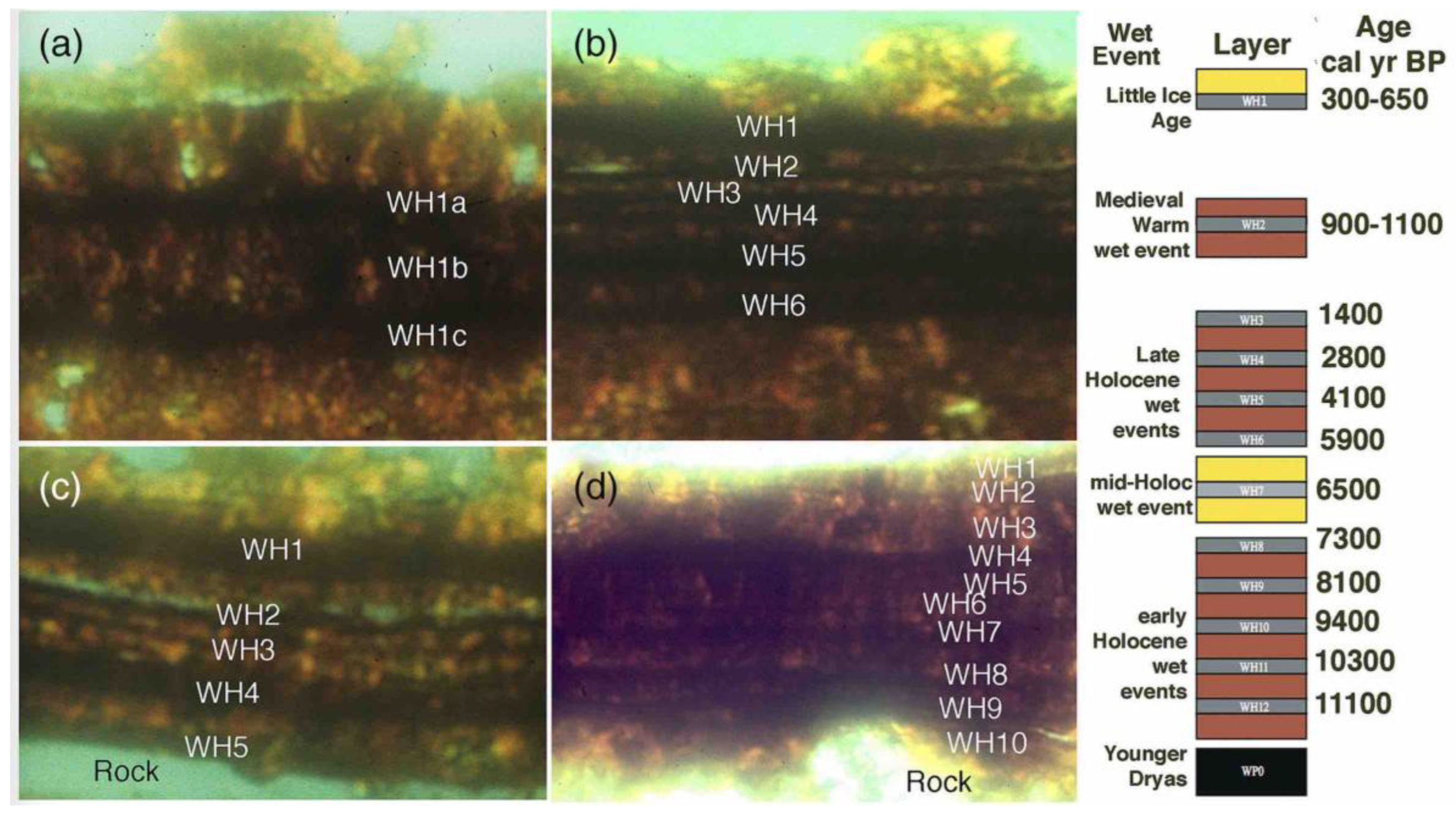
Figure 2.
At the Mesa cleared pavement patch, high resolution transmission electron microscopy and energy dispersive spectroscopy reveals varnish formation in small microdepressions after 19 years of exposure. This incipient varnish first accumulated as unlaminated varnish. The energy dispersive spectrometry analysis is that of typical rock varnish, and it is on a spot of disorganized varnish. Then, laminated varnish with a similar chemistry formed on top of the more disorganized material.
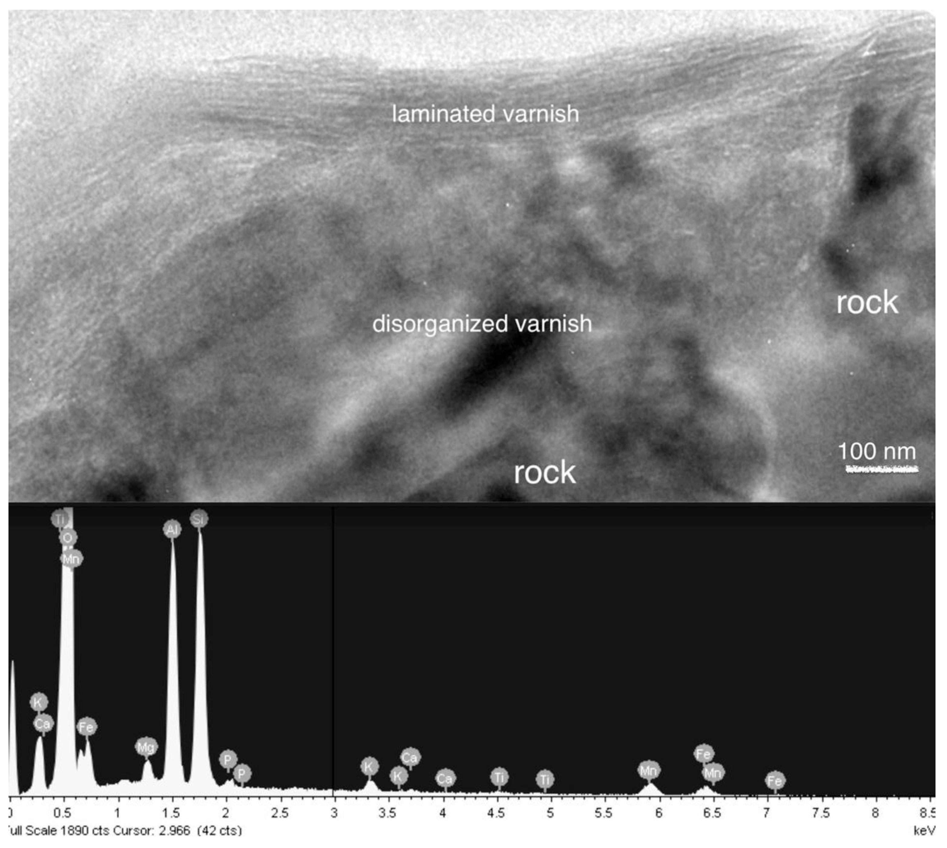
Figure 3.
Air photo of the so-called “Blythe Giant Figures,”California, on a terrace above the Colorado River. One of the two anthropomorphic intaglios (encircled by a fence) is shown here; it is about 52-meters long. The anthropomorphs portray the creator god Mastamho and his twin brother. The quadruped is Hatakulya, one of two mountain lion spirit-beings who helped in the creation, with a spiral underneath. Minimum varnish ages (Table 1) indicate that these intaglios are at least 1000 – 1100 years old. Other scars in the desert pavement were created by off-road vehicles (Google Earth).
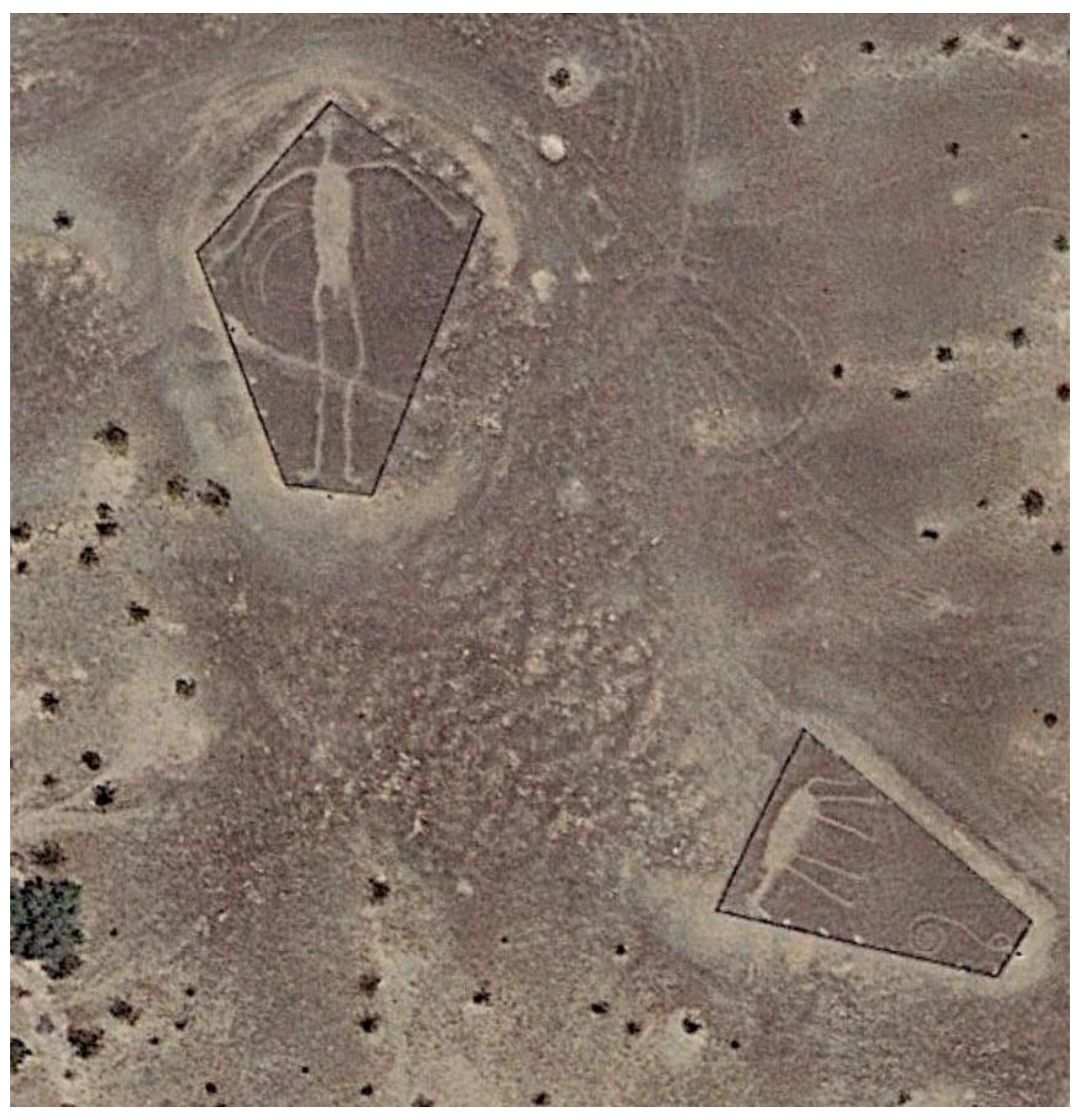
Figure 4.
VML sequences on Ripley Complex intaglios: (A) cross and (B) large anthropomorph. The orange basal layer of the cross VML puts its age between 1100 and 1400 cal yr BP, and the black WH2 basal layer is 1400 cal yr BP. CR ages in Table 1 and lead-profile analyses indicated on the VML sequences are particularly useful here, because they provide additional confidence that the three Little Ice Age wet periods (WH1a, WH1b, WH1c) are correctly identified in this VML sequence. Each of these sections has a thickness of ~12 µm.
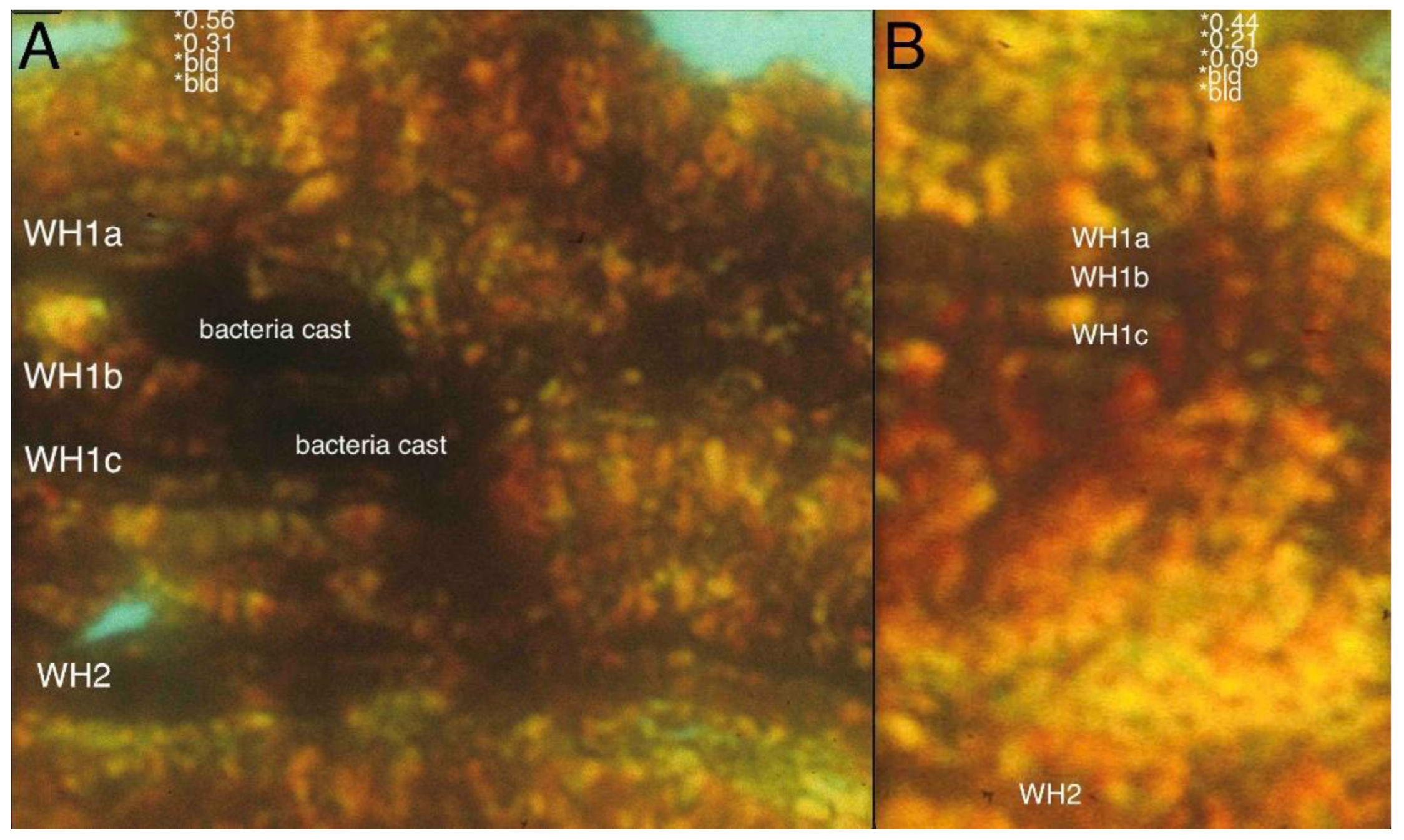
Figure 5.
Air photo of the Quien Sabe Point site, showing the estimated VML ages for three motifs: a long zigzag at the bottom and middle, and two anthropomorphs at the top with their legs extending to the cliff edge along the Colorado River. (Photo courtesy of Harry Casey; large creosote bushes, approximately 2 meters in diameter, for scale).
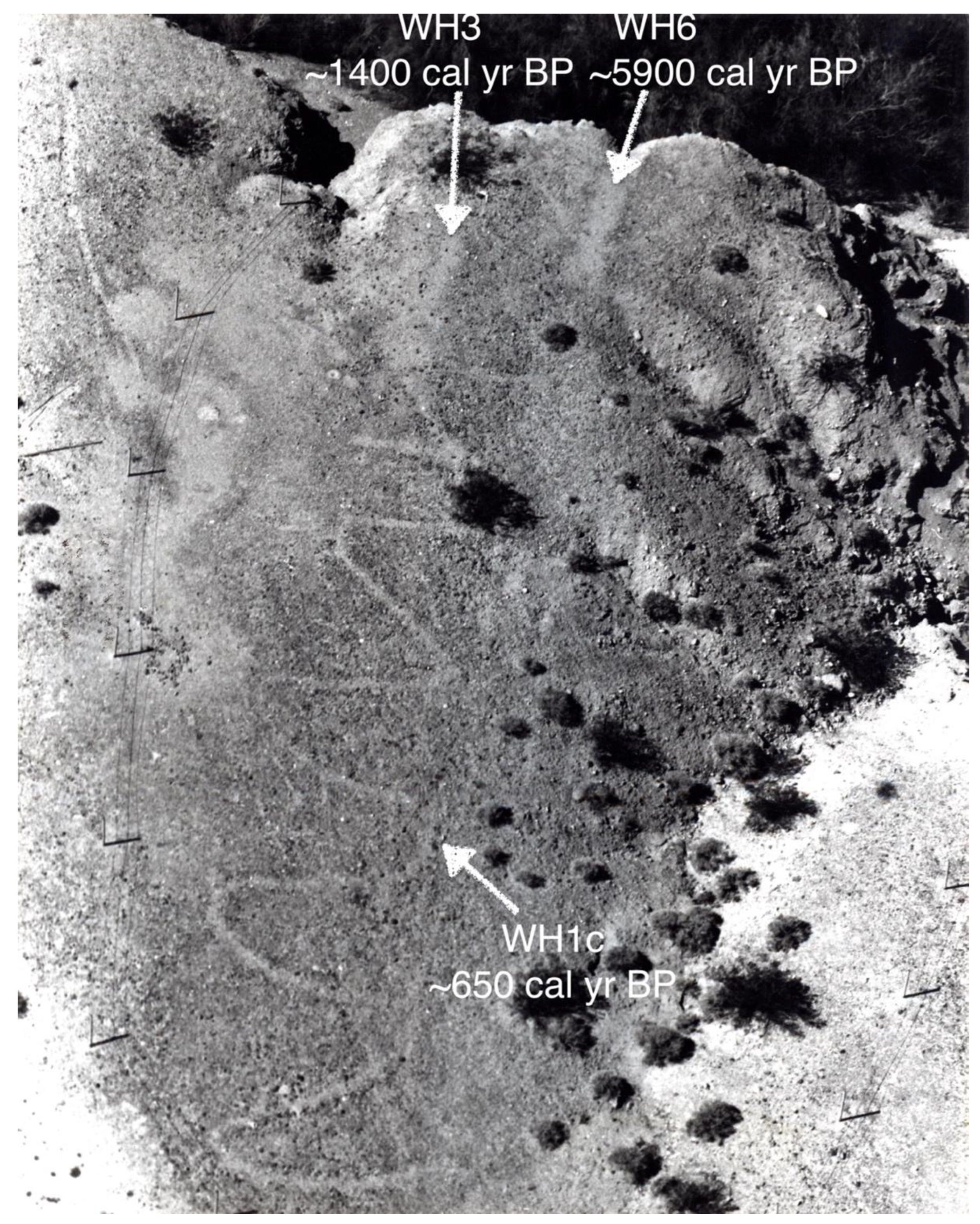
Figure 6.
The oldest VML sequences for each of the three sampled intaglios at the Quien Sabe Point site (see Figure 5). A) Oldest VML age of ten cobbles sampled from the older anthropomorph is WH6; section thickness is 45 µm. B) Oldest VML age of ten cobbles sampled from the younger anthropomorph is WH3; section thickness is 25 µm. C) Oldest VML age of ten cobbles sampled from a zigzag/‘snake’ figure; section thickness is 17 µm. Note the lead-profile dating measurements and the spike of lead in the upper few microns, consistent with the assignment of the Little Ice Age WH 1 wet periods in all three profiles.
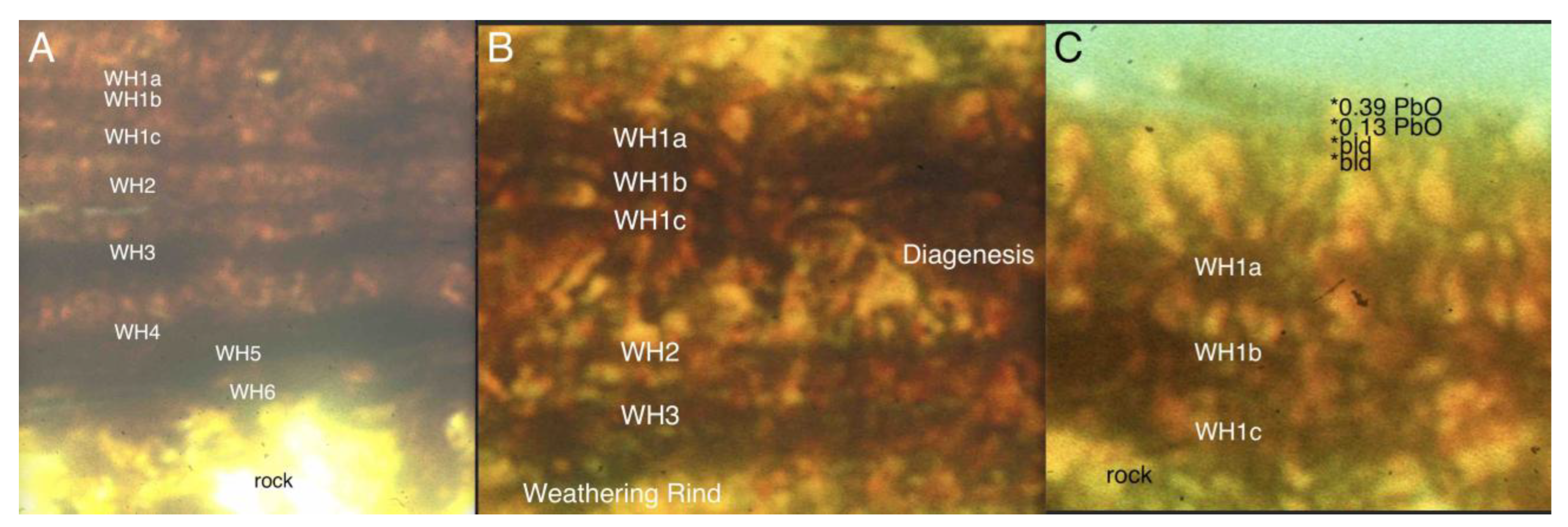
Figure 7.
Air photo of the Singer Complex site showing two long snake-like intaglios, a graded dirt road and fainter tank tracks resulting from World War II armored infantry training exercises. (Photo courtesy of Harry Casey; double-lane dirt bisecting photo for scale).
Figure 7.
Air photo of the Singer Complex site showing two long snake-like intaglios, a graded dirt road and fainter tank tracks resulting from World War II armored infantry training exercises. (Photo courtesy of Harry Casey; double-lane dirt bisecting photo for scale).
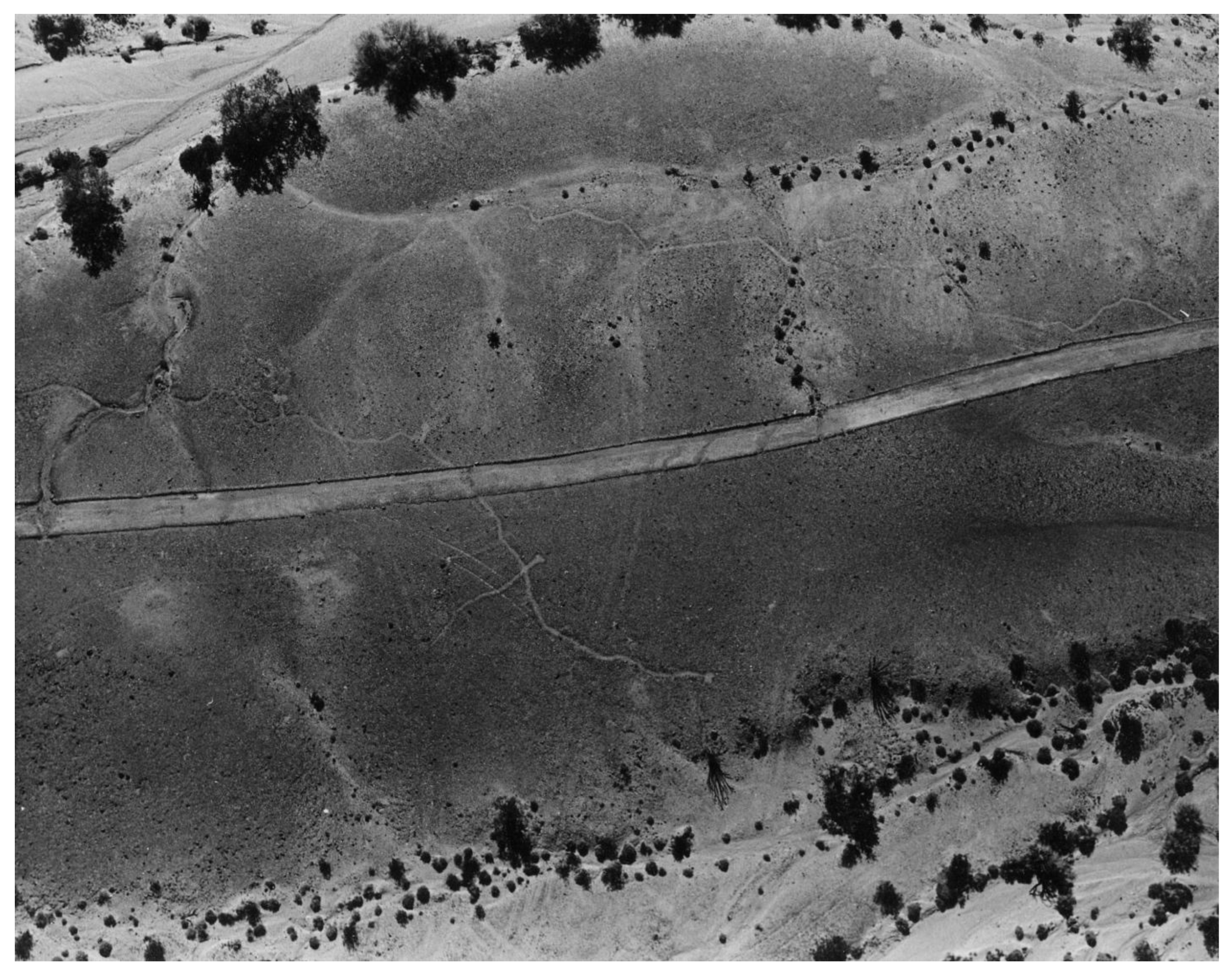
Figure 8.
Oldest VML sequence for Oatman trail (A, thickness ~18 µm) with back-scattered electron image of an Oatman trail cobble showing pockets of post-Little Ice Age varnishing for context (B, scale bar 10 µm). In this image, these pockets are much brighter, because of the presence of Mn and Fe, as compared to the quartz mineralogy of the cobble.
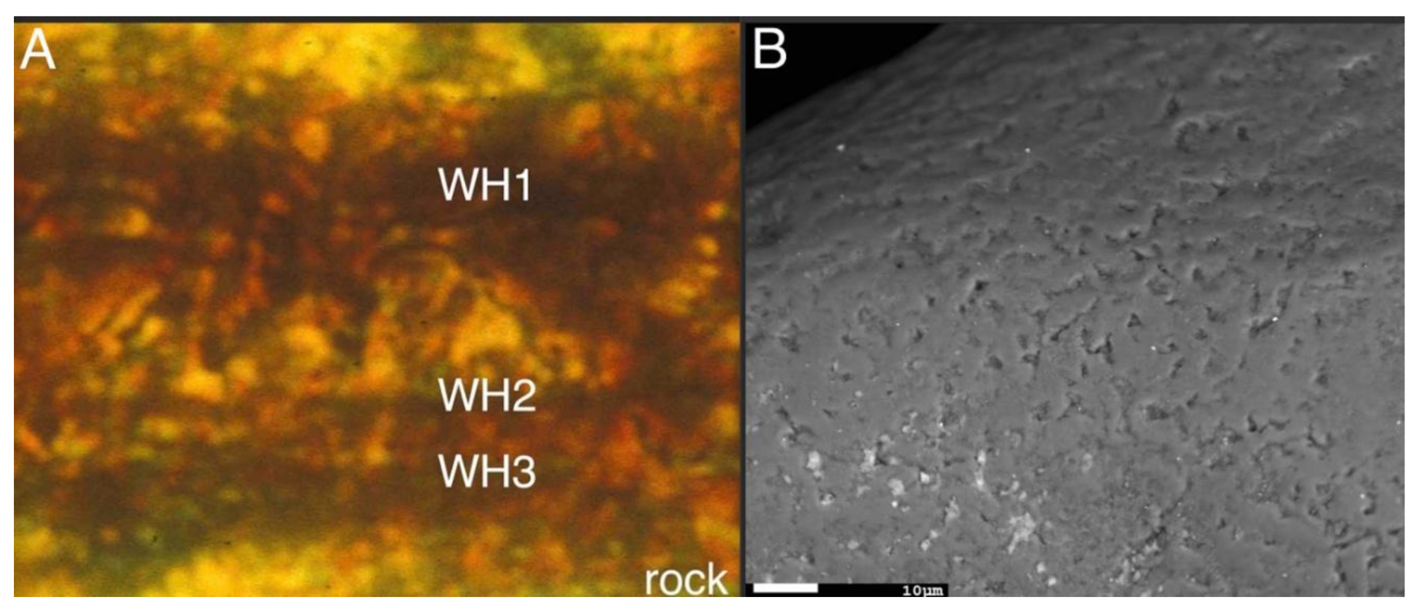
Figure 9.
Air photo of a portion of the southern section of the Topock Maze. (Google Earth; single-lane dirt road, lower left, for scale).
Figure 9.
Air photo of a portion of the southern section of the Topock Maze. (Google Earth; single-lane dirt road, lower left, for scale).
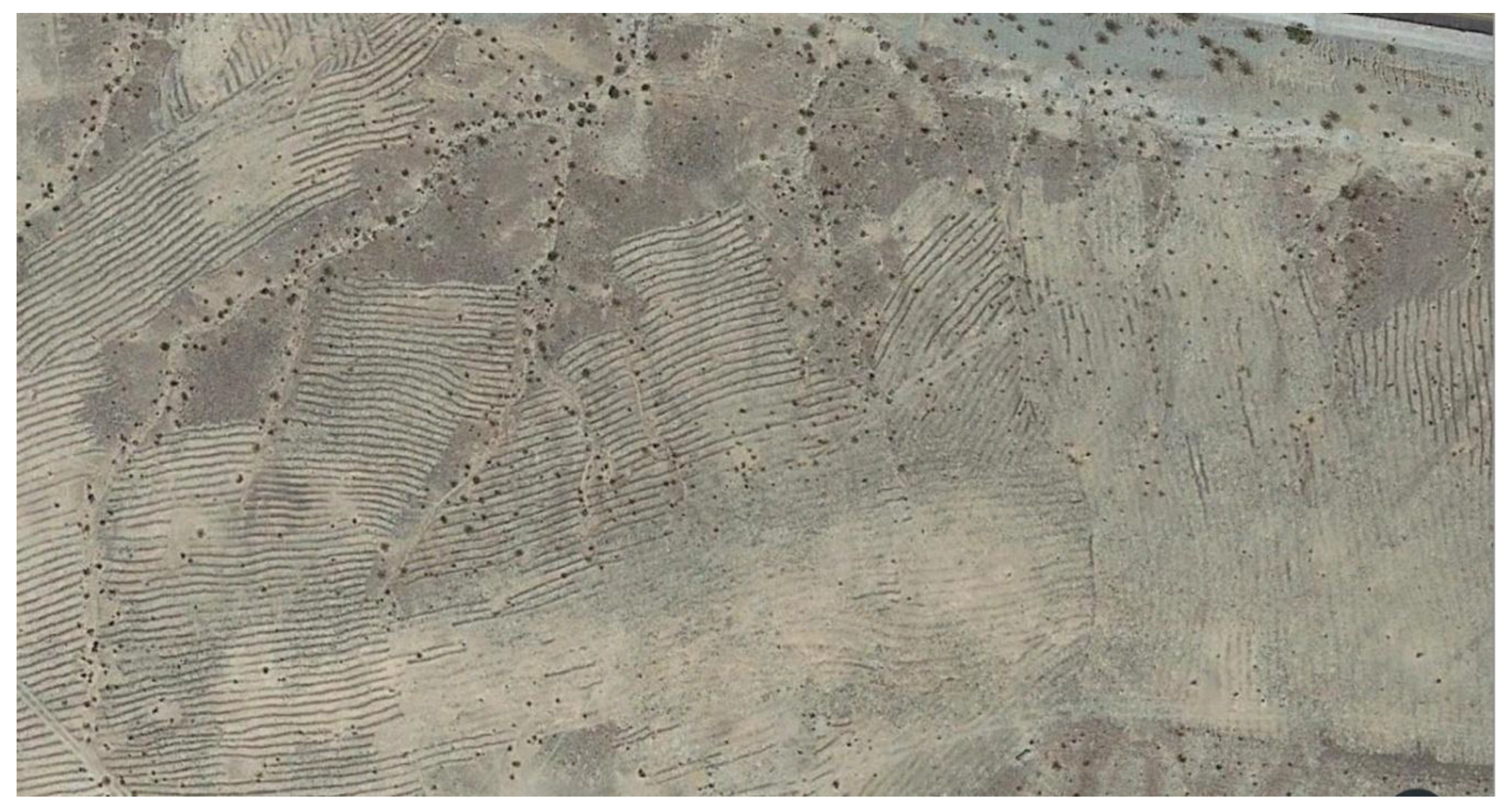
Figure 10.
Ground view of SW area of Topock Maze showing intact desert pavement in foreground, parallel “maze” rows in center, and disturbed pipeline corridor towards middle right. (David S. Whitley; 3-ft high fence posts for scale at end of row).
Figure 10.
Ground view of SW area of Topock Maze showing intact desert pavement in foreground, parallel “maze” rows in center, and disturbed pipeline corridor towards middle right. (David S. Whitley; 3-ft high fence posts for scale at end of row).
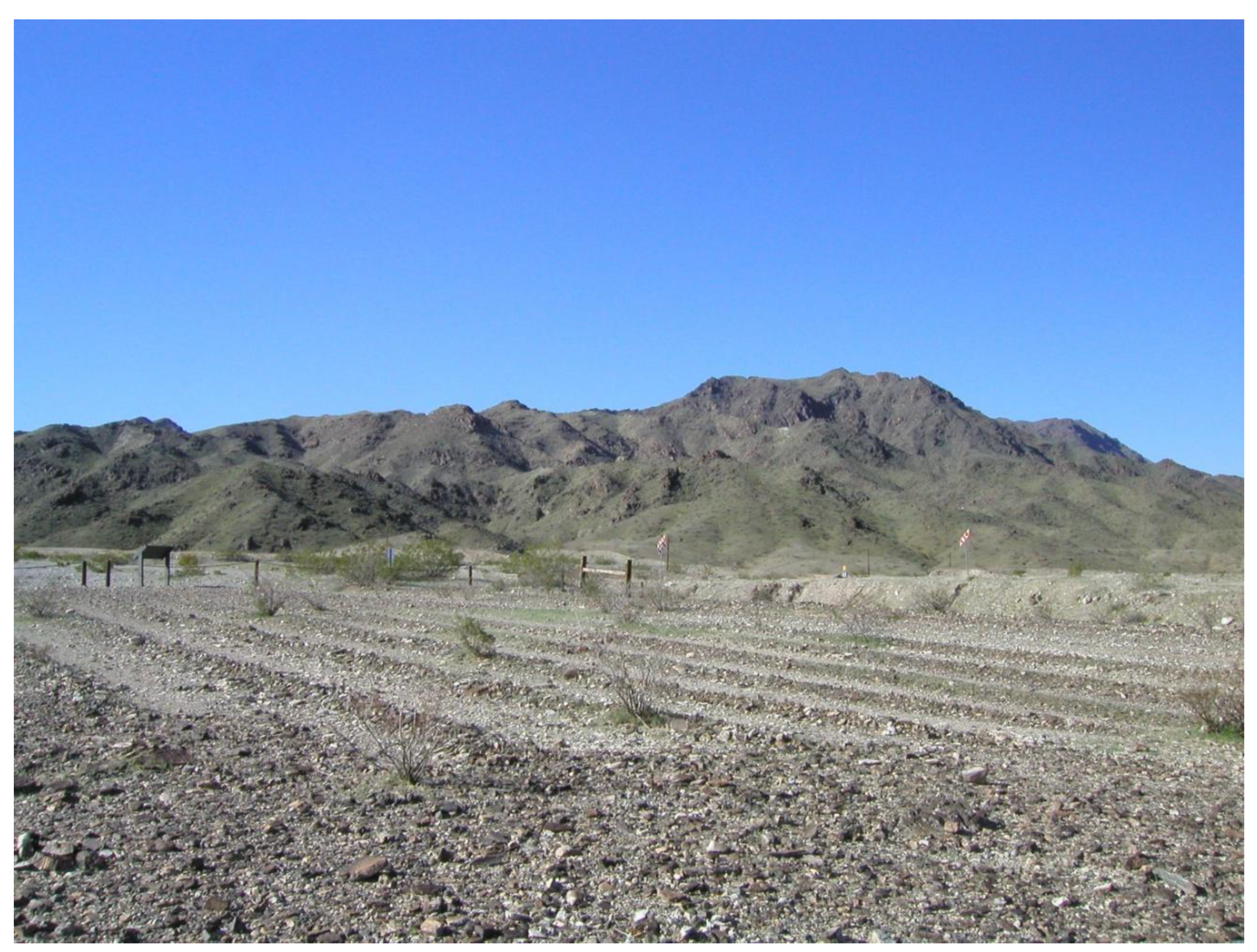
Figure 11.
Turn-of-the-century Fred Harvey Company picture postcard painting of Topock Maze showing shrine originally associated with this site.
Figure 11.
Turn-of-the-century Fred Harvey Company picture postcard painting of Topock Maze showing shrine originally associated with this site.
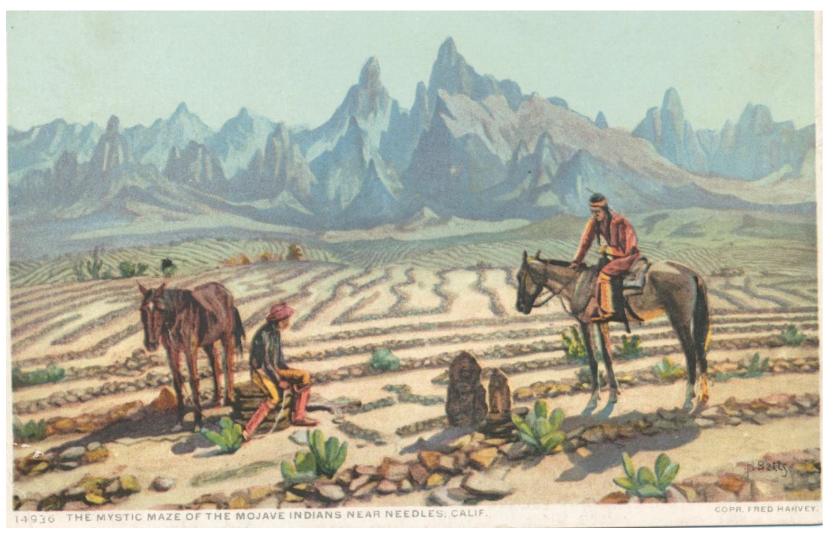
Figure 12.
The oldest VML sequences on four cobbles collected from the Topock Maze. The distance between lead-profile analyses (asterisks) is 1 micron. BLD is ‘below limit of detection,’ demonstrating that Industrial Revolution surface spikes are underlain by background levels of lead. The area of “diagenesis” in image C shows an area of Mn-Fe leaching and reprecipitation. Varnish thicknesses range between 17 µm and 30 µm.
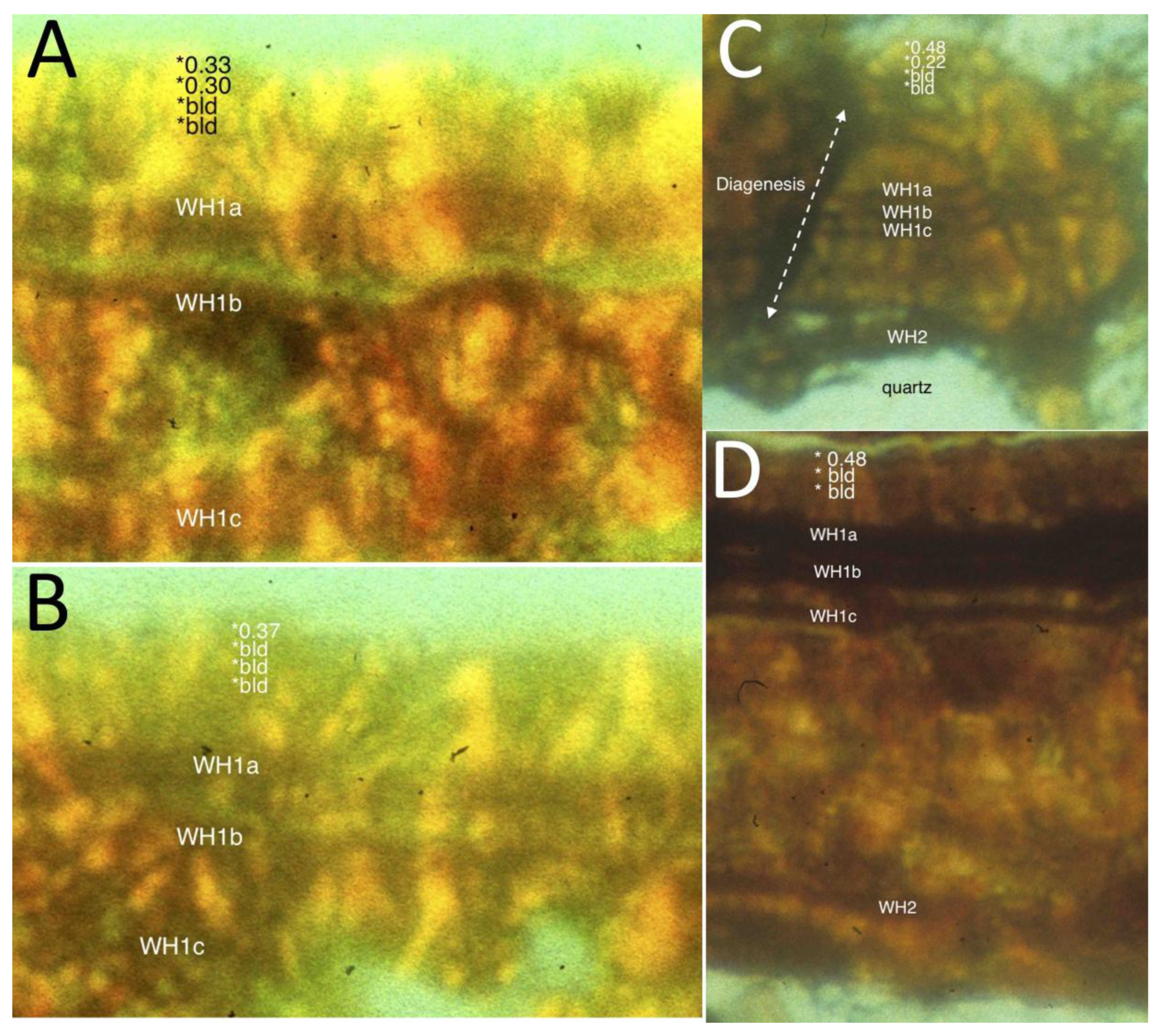
Figure 13.
“Control” cobble collected outside the Topock Maze displays an angular unconformity where much older varnish (“inherited”) is truncated via erosion. Then, the VML sequence starting with WH5 was deposited on the eroded varnish. C-B indicates the presence of cyanobacteria that dissolved varnish and then resulted in infilling of areas of disturbed laminations. Varnish thickness is 30 µm at the deepest. The Holocene VML calibration of Liu and Broecker (2007) is displayed for reference (WH1 occurs in this section as Little Ice Age Layers WH1a-c, because of the varnish accumulated fast enough to record these climatic events).
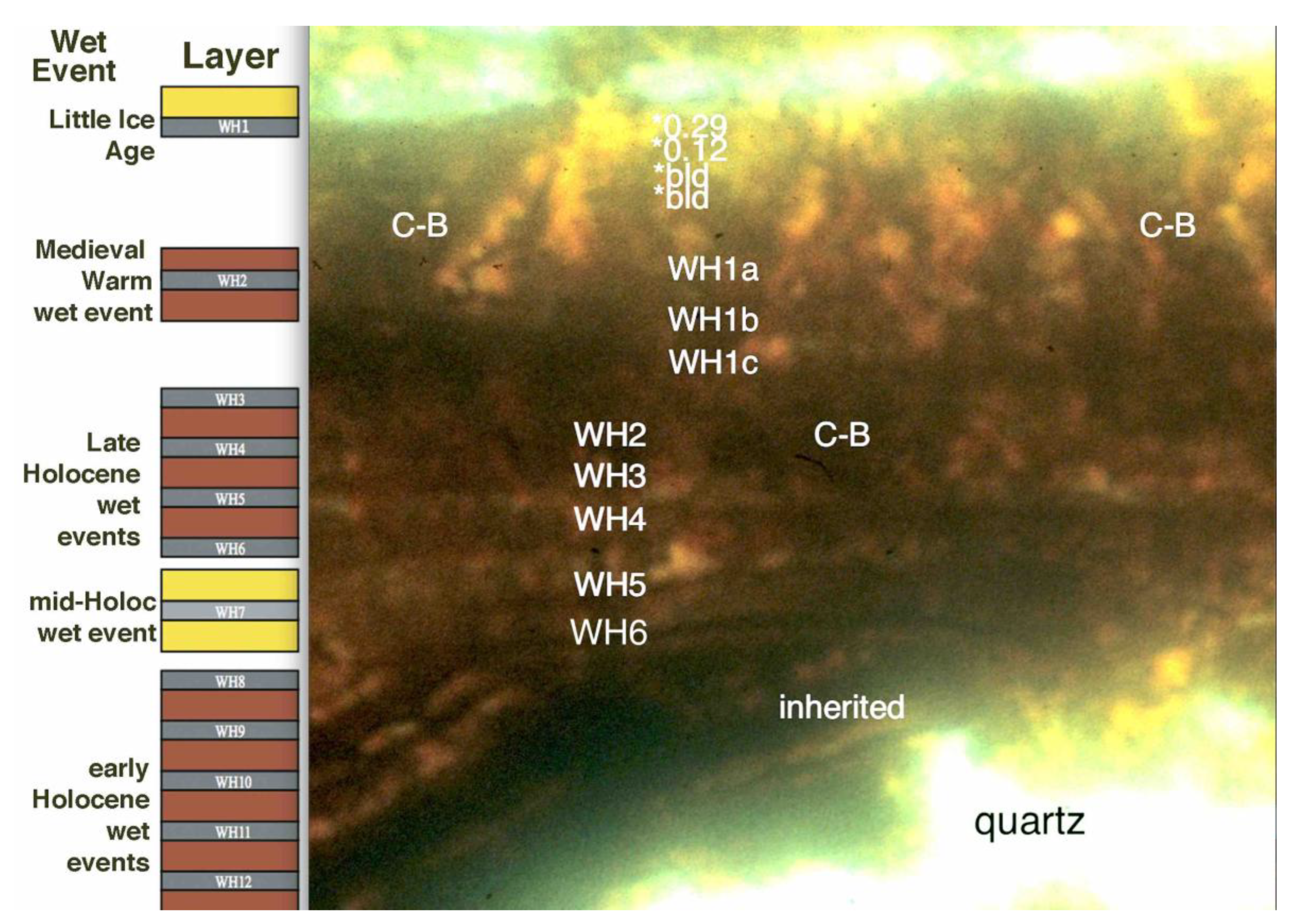
Figure 14.
On the north end of Quartzsite, Arizona, desert pavement contains a high density of cleared circles. Circle #6 (Table 2) is shown here. (A) Google Earth image with 2-lane roads and a 200 m bar for scale. (B) 3-4 m diameter cleared circle sampled for VML. (C) Ultrathin section of rock varnish that is about 20 µm thick, displaying a VML sequence of the late Medieval Warm Period underneath the Little Ice Age (WH1a, b, c). Electron microprobe measurements of lead (PbO) reveal the 20th century spike in lead with natural background levels (“bld” – below level of detection) underneath.
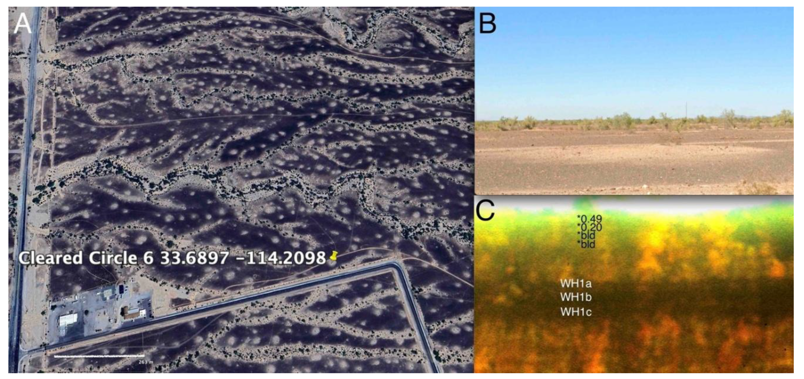
Table 2.
Minimum VML ages for randomly selected cleared circles in the lower Sonoran Desert.
| No. | Coordinates | Lead Profile | VML Sequence | Age (cal years BP) |
|---|---|---|---|---|
| 1 | 33.8261 -114.0570 | pre-20th Cent | WH1-WH2 | 650 - 900 |
| 2 | 33.1261 -114.2908 | pre-20th Cent | WH1-WH2 | 650 - 900 |
| 3 | 32.9698 -114.2845 | pre-20th Cent | WH1-WH2 | 650 - 900 |
| 4 | 32.6897 -114.2098 | pre-20th Cent | WH1-WH2 | 650 - 900 |
| 5 | 32.8656 -114.3477 | pre-20th Cent | WH1-WH2 | 650 - 900 |
| 6 | 33.6897 -114.2098 | pre-20th Cent | WH1-WH2 | 650 - 900 |
| 7 | 33.6693 -113.9893 | pre-20th Cent | WH2 | 900-1100 |
| 8 | 32.9852 -112.9911 | pre-20th Cent | WH1-WH2 | 650 - 900 |
| 9 | 33.0285 -113.1485 | n/a | WH2 | 900-1100 |
| 10 | 33.0449 -113.4311 | n/a | WH1-WH2 | 650 - 900 |
| 11 | 32.9596 -113.5975 | n/a | WH1-WH2 | 650 - 900 |
| 12 | 32.9041 -113.6529 | n/a | WH1-WH2 | 650 - 900 |
| 13 | 32.8881 -113.6857 | n/a | WH2 | 900-1100 |
| 14 | 32.8481 -113.8429 | n/a | WH2 | 900-1100 |
| 15 | 32.7940 -114.0436 | n/a | WH2-WH3 | 1100-1400 |
| 16 | 32.6267 -114.3696 | n/a | WH1-WH2 | 650 - 900 |
Disclaimer/Publisher’s Note: The statements, opinions and data contained in all publications are solely those of the individual author(s) and contributor(s) and not of MDPI and/or the editor(s). MDPI and/or the editor(s) disclaim responsibility for any injury to people or property resulting from any ideas, methods, instructions or products referred to in the content. |
© 2025 by the authors. Licensee MDPI, Basel, Switzerland. This article is an open access article distributed under the terms and conditions of the Creative Commons Attribution (CC BY) license (http://creativecommons.org/licenses/by/4.0/).
Copyright: This open access article is published under a Creative Commons CC BY 4.0 license, which permit the free download, distribution, and reuse, provided that the author and preprint are cited in any reuse.


