
Submitted:
08 July 2025
Posted:
11 July 2025
You are already at the latest version
Abstract
On July 19, 2023, an EF-3 tornado struck Rocky Mount, North Carolina, severely impacting the environment and damaging Pfizer’s pharmaceutical facility. This project uses the Normalized Difference Vegetation Index (NDVI) to analyze environmental vulnerability before and after the tornado. Landsat 8 satellite imagery was used to compare NDVI data from two weeks before and four weeks after the event. Using ArcGIS, zonal statistics and raster analysis identified areas of significant vegetation loss across urban, forested, and agricultural zones along the 16-mile tornado path. Results revealed notable decreases in NDVI values, indicating widespread loss of vegetation and soil disruption. Damage to the Pfizer plant, which produces about 25% of U.S. hospital-injectable medicines, emphasized the tornado’s critical pharmaceutical impact. This study demonstrates how geospatial science tools like NDVI can assess environmental vulnerability and disaster impact, helping guide future planning, emergency response, and infrastructure resilience in a changing climate.
Keywords:
EF-3 tornado
; environmental impact
; geospatial analysis
; disaster resilience
; vegetation change
Introduction
On July 19, 2023, an EF-3 tornado with peak winds of approximately 150 mph touched down in northern Nash County, NC, paving a 16 mile path of destruction through Dortches, Battleboro, and Rocky Mount; damaging or destroying 38–90 homes, injuring 15 people, and severely impacting critical infrastructure such as a Pfizer plant, power lines, and buildings.
Why This Matters
Tornadoes like the EF-3 in Rocky Mount damage both ecosystems and infrastructure. NDVI(Normalized Difference Vegetation Index) analysis helps track environmental recovery in affected landscapes. By comparing urban and rural land cover impacts, we identify weak points in resilience. As climate change intensifies weather events, understanding these patterns informs future planning. Finally, mapping damage highlights vulnerable, underserved communities that may need greater support in recovery efforts.
Research Objectives
- Objective 1: Quantify environmental degradation from the EF-3 tornado in Rocky Mount using NDVI(Normalized Difference Vegetation Index).
- Objective 2: Evaluate pharmaceutical production vulnerability via geospatial analysis of infrastructure and land loss.
Study Area
The Rocky Mount region, located in eastern North Carolina within Edgecombe and Nash counties, features flat terrain, moderate elevation, and a diverse mix of land use — including forested areas, agricultural zones, and urban development. This landscape, combined with the presence of critical infrastructure such as pharmaceutical facilities and supply routes, makes Rocky Mount a valuable case study for evaluating the environmental impacts of extreme weather using NDVI (Normalized Difference Vegetation Index).
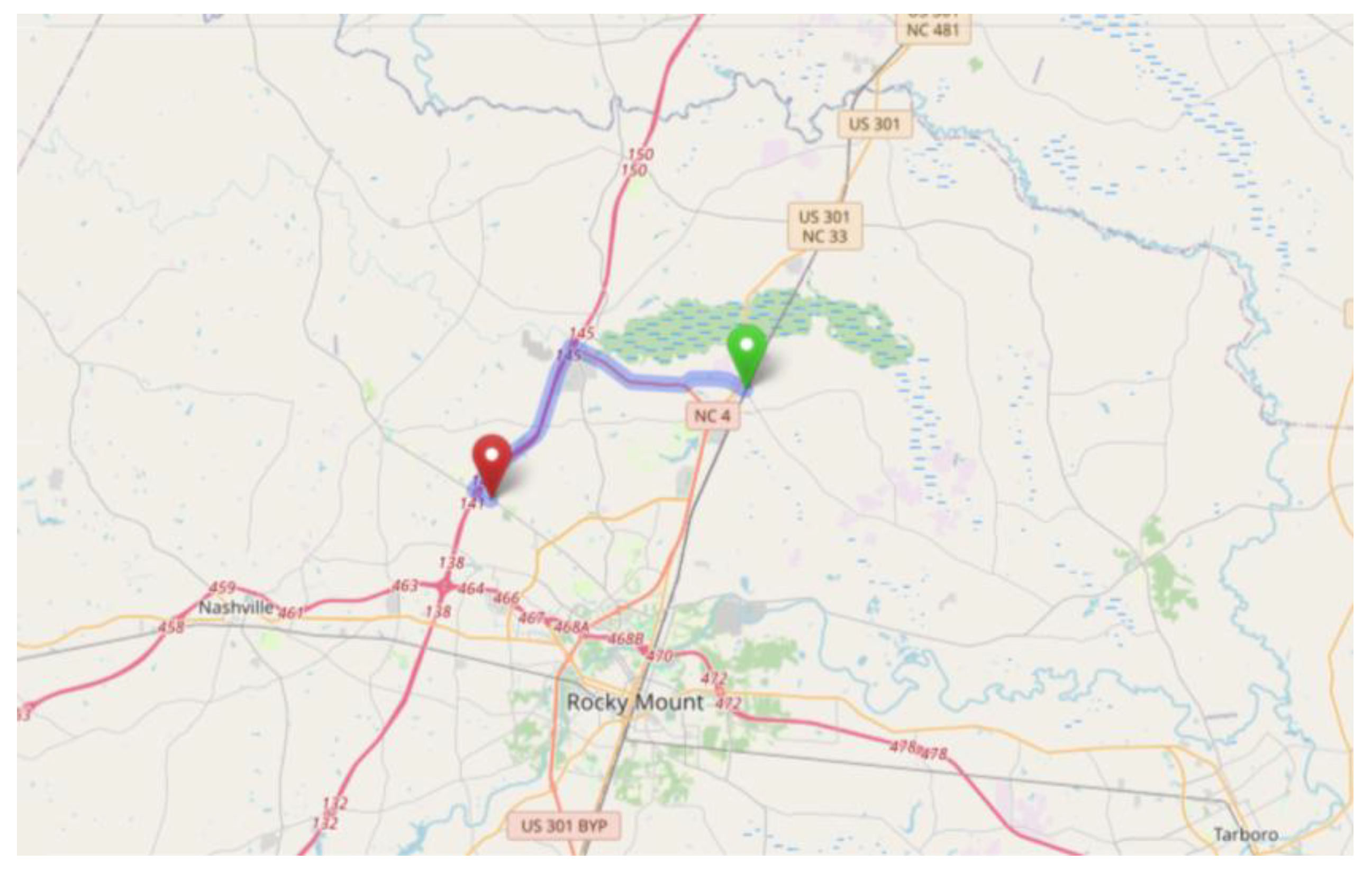
The EF-3 tornado that struck the region in 2023 carved a predominantly linear path approximately 16 miles long and 600 yards wide, stretching from Dortches to Battleboro. This corridor experienced significant vegetation loss and infrastructure disruption, making it the focal zone of geospatial analysis in this research.
Figure 1.
Tornado path through Rocky Mount, NC (OpenStreetMap).
Data
To analyze the impact of the EF-3 tornado, two Landsat 8 satellite scenes with 30-meter spatial resolution were obtained from the USGS EarthExplorer platform. These scenes represent surface reflectance data captured before and after the tornado event, enabling a comparative study of vegetation changes.
- Scene 1: Acquired on July 5, 2023, two weeks prior to the tornado.
- Scene 2: Acquired on August 16, 2023, three weeks following the tornado.
Both scenes focus on the broader affected region, with special emphasis on the area surrounding the Pfizer pharmaceutical plant to assess localized environmental and infrastructural changes.
Figure 2.
NDVI Composite Images of Rocky Mount, NC. The left panel shows pre-tornado conditions, while the right panel illustrates post-tornado conditions after the July 2023 EF-3 tornado.
Figure 2.
NDVI Composite Images of Rocky Mount, NC. The left panel shows pre-tornado conditions, while the right panel illustrates post-tornado conditions after the July 2023 EF-3 tornado.
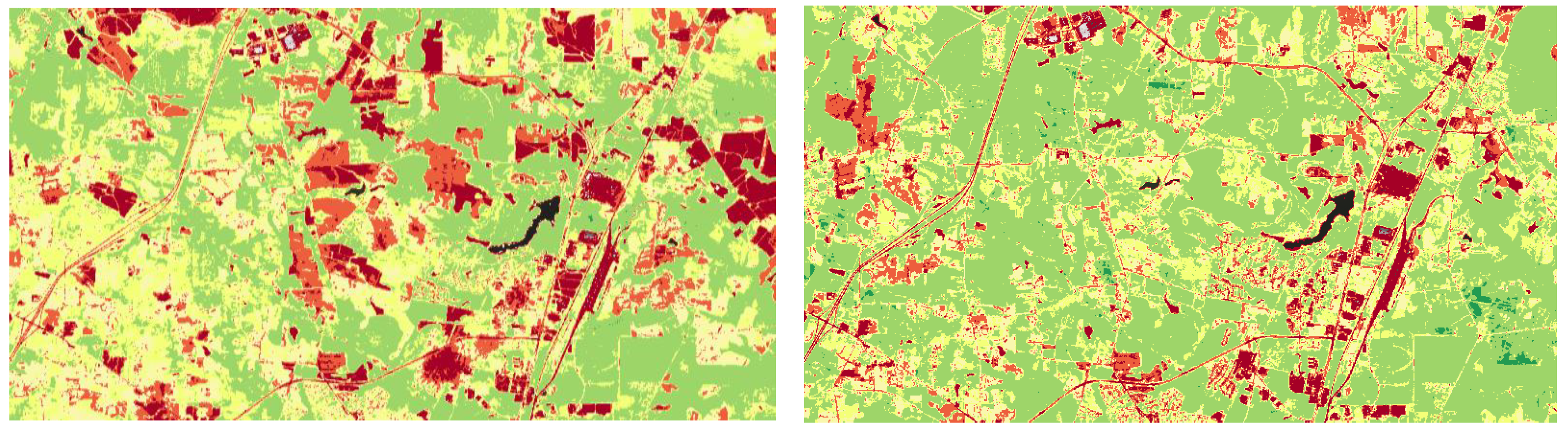
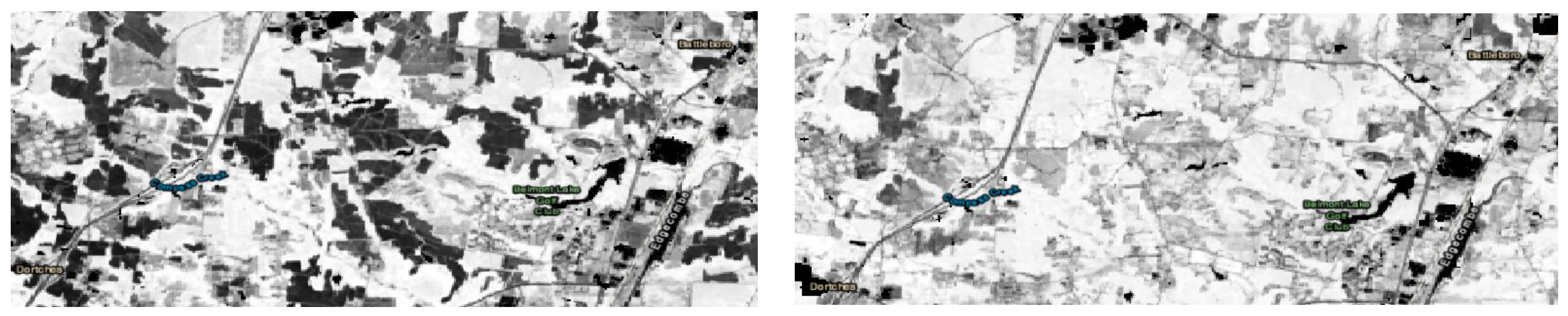
Figure 3.
Zoomed-in ArcGIS views highlighting The left panel shows pre-tornado conditions, while the right panel illustrates post-tornado conditions after the July 2023 EF-3 tornado.
Figure 3.
Zoomed-in ArcGIS views highlighting The left panel shows pre-tornado conditions, while the right panel illustrates post-tornado conditions after the July 2023 EF-3 tornado.
Methodology
We used the Normalized Difference Vegetation Index (NDVI) to detect changes in vegetation health in Rocky Mount, North Carolina, following the EF-3 tornado on July 19, 2023. To capture both immediate and short-term environmental impacts, NDVI data spanning five weeks, from July 5, 2023, to August 16, 2023, were analyzed.
Data Collection:
NDVI imagery was derived from 8-day composite Landsat 8 surface reflectance data, accessed via the USGS EarthExplorer platform.
Temporal Coverage:
- July 5, 2023; two weeks prior to the tornado
- August 16, 2023; four weeks post-tornado (to assess immediate damage)
Image Processing:
- Import geoJSON files defining the study area into the NDVI viewer for each selected date.
- Use classification tools within the NDVI viewer to compare vegetation health between time points.
Thresholding and Classification:
An NDVI threshold was applied to differentiate vegetated from non-vegetated areas:
- 3.
- NDVI values close to 1 (green) indicate healthy vegetation.
- 1.
- NDVI values close to -1 (yellow) indicate sparse vegetation, bare land, or damaged areas.
Quantitative Analysis:
Zonal statistics were calculated to determine mean NDVI values and total vegetated area for each time slice. Vegetation health before and after the tornado was compared, and the difference in vegetated area was used to estimate infrastructure and vegetation loss.
Data Export and Visualization:
Statistical outputs were exported to Excel spreadsheet software to generate graphs illustrating vegetation change over time.
Interpretation:
Decreases in NDVI values were interpreted as vegetation destruction due to tornado winds, including fallen trees and damaged cropland.
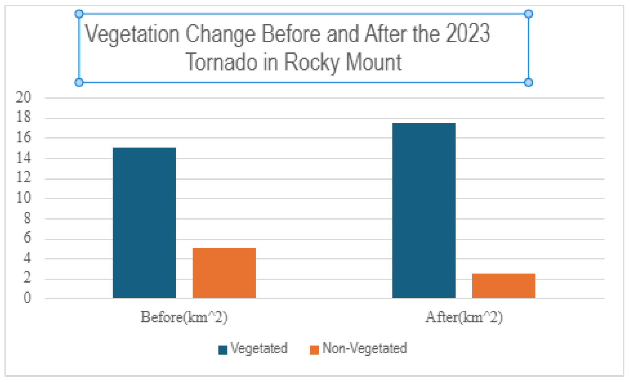
Figure 4.
Comparison of vegetated and non-vegetated land area (km^2) in Rocky Mount, NC before and after the July 2023 EF-3 tornado.
Figure 4.
Comparison of vegetated and non-vegetated land area (km^2) in Rocky Mount, NC before and after the July 2023 EF-3 tornado.
Results
The NDVI comparison before and after the EF-3 tornado in Rocky Mount reveals a significant decline in healthy vegetation across the impacted area. This drop in vegetation index values supports the conclusion that high-wind natural disasters can cause severe environmental disruption.
As noted by Huete et al. (2002), “Vegetation indices such as NDVI allow rapid detection of environmental changes over time using remote sensing.” Our findings align with this, demonstrating the power of NDVI as a diagnostic tool for post-disaster ecological assessment.
Environmental Impact:
The loss of vegetative cover has several cascading effects on the ecosystem. Reduced vegetation can accelerate surface runoff, increase soil erosion, and fragment habitats. Damage to green infrastructure—such as forest buffers and cropland—not only reduces ecosystem services but also increases the vulnerability of surrounding built infrastructure. These environmental consequences underscore the importance of vegetation in community resilience to extreme weather events.
Pharmaceutical Infrastructure Impact:
The tornado inflicted major damage on the Pfizer Pharmaceutical Plant in Rocky Mount, a facility responsible for producing approximately 25% of the nation’s injectable hospital medications, particularly pain management drugs and anesthetics. The tornado destroyed the plant’s roof and splintered its structure, ruining an estimated 50,000 pallets of medicine and disabling 100 key transport vehicles, including forklifts. Notably, half of the pharmaceuticals manufactured at this site appear on the FDA’s Essential Medicines List.
This event highlights the broader public health implications of localized natural disasters, demonstrating how damage to a single facility can disrupt nationwide medical supply chains.
These results emphasize the importance of satellite-based remote sensing tools like NDVI in rapidly assessing both environmental and infrastructural damage. Such tools are essential for guiding disaster response, ecological restoration, and long-term resilience planning across multiple sectors.
Conclusions & Discussion
The EF-3 tornado in Rocky Mount, NC, demonstrated the significant environmental and industrial vulnerabilities to natural disasters. NDVI analysis confirmed vegetation loss across diverse land types, with agricultural and urban areas experiencing the most damage. In parallel, the tornado severely affected the Pfizer plant, disrupting national pharmaceutical supply chains. This dual impact highlights how localized disasters can cascade into national-level consequences, particularly in public health.
Our findings support the need for proactive environmental monitoring, improved infrastructure resilience, and geospatial tools in emergency response planning. In the future, combining NDVI with socioeconomic and flood risk data could enhance damage prediction and equitable disaster recovery efforts. This project illustrates how satellite remote sensing and GIS technologies can guide data-driven strategies for climate adaptation and disaster resilience.
Acknowledgments
NASA Precollege Summer Institute of Earth Science and Geospatial Science at Fayetteville State University - 2023-2028 (www.uncfsu.edu/geospatial/nasapsi).

References
- Huete, Alfredo R., Kamel Didan, Tomoaki Miura, Ernesto P. Rodriguez, Xiaoyang Gao, and Luiz G. Ferreira. “Overview of the Radiometric and Biophysical Performance of the MODIS Vegetation Indices.” Remote Sensing of Environment 83, no. 1–2 (November 2002): 195–213. [CrossRef]
- Aubrey, Allison. “Pfizer Tornado Damage Adds to Drug Supply Woes.” NPR, July 27, 2023. https://www.npr.org/sections/health-shots/2023/07/27/1190507719/tornadopfizer-factory-drug-shortages.
- WRAL News. “Tornado Severely Damages Pfizer Facility in Rocky Mount, NC.” WRAL, July 19, 2023. https://www.wral.com/story/pfizer-tornado-damage-july-19-2023-north-carolina-tornado-injured-people-destroyed-homes/20961973/.
- CBS News. “Tornado Damage at Pfizer Plant Could Lead to Long-Term Medicine Shortages.” CBS News, July 20, 2023. https://www.cbsnews.com/news/tornado-pfizer-plant-north-carolina-damage-long-term-medicine-shortages/.
- Weiland, Noah. “Tornado Damages Pfizer Plant in North Carolina, Threatening Drug Supply.” The New York Times, July 20, 2023. https://www.nytimes.com/2023/07/20/health/tornado-pfizer-drug-shortage.html.
Disclaimer/Publisher’s Note: The statements, opinions and data contained in all publications are solely those of the individual author(s) and contributor(s) and not of MDPI and/or the editor(s). MDPI and/or the editor(s) disclaim responsibility for any injury to people or property resulting from any ideas, methods, instructions or products referred to in the content. |
© 2025 by the authors. Licensee MDPI, Basel, Switzerland. This article is an open access article distributed under the terms and conditions of the Creative Commons Attribution (CC BY) license (http://creativecommons.org/licenses/by/4.0/).
Copyright: This open access article is published under a Creative Commons CC BY 4.0 license, which permit the free download, distribution, and reuse, provided that the author and preprint are cited in any reuse.


