
Submitted:
17 June 2025
Posted:
18 June 2025
You are already at the latest version
Abstract
Nowadays Internet connectivity suffers from instability and slowness due to optical fiber cable attacking across the sea and oceans. The optimal solution of this problem is using the Low Earth Orbit (LEO) satellite network which can resolve the problem of Internet connectivity and reachability, and it has the power to bring real-time, reliable, low latency, high bandwidth, cost-effective Internet access to many urban and rural areas in any region of the earth. However, satellite orbital placement and navigation should be carefully designed to reduce the signal impairments. The challenges of orbital satellite placement for LEO are constellation development, satellite parameters optimalisation, bandwidth optimization, consideration signal impairments, and coverage are dimeters. This paper presents a comprehensive review of satellite orbital placement, coverage optimization, prevalent issues affecting LEO Internet connectivity, evaluates existing solutions and suggests novel solutions to address these challenges. Furthermore, it recommends machine learning solution based for coverage optimization and satellite orbital placement that can be used to efficiently enhance the internet reliability and reachability for LEO satellite networks. This survey will open up the gate for developing an optimal solution for global Internet connectivity and reachability.
Keywords:
satellite placement
; LEO
; optimization parameters
1. Introduction
Recently, the war on the Red Sea and other places over the world affects the main submarine communications cables which has catastrophic impact on the Internet connectivity and reachability. Consequently, industrial development and economics growth cannot meet a variety of data communication needs using the current submarine communications cables and a new Internet solution is vital. The Low Earth Orbit (LEO) satellites networks offer distinct advantages over traditional terrestrial infrastructures, such as fiber-optic and mobile networks. They provide optimal coverage area and high bandwidth to enhance global internet connectivity, particularly in remote or underserved regions where laying physical infrastructure is challenging. LEO satellite network is considered as the important solution to bring real-time, reliable, low latency, high bandwidth, cost-effective for Internet service in many urban and rural areas on the earth. In recent years, several commercial companies have developed LEO satellite constellations comprising hundreds or even thousands of satellites [1,2,3,4]. For instance, SpaceX's Starlink, OneWeb (now part of Eutelsat), and Telesat's Lightspeed network. Some of these constellations have already achieved partial deployment, with Starlink operating over 7,000 satellites and OneWeb deploying 648 satellites as of early 2025 [5].
Satellite orbital optimization focuses on selecting the most suitable orbital parameters which are known as Keplerian elements to define the orbits of a satellite constellation and to determine the optimal placement of satellites within those orbits. It can be divided into two categories which are performance-based optimization and feasibility-based optimization [6]. Performance-based ensures the orbital configuration in terms of satellite count, orbital parameters, and coverage patterns is optimized to meet the desired performance criteria. Hence, it enhances global communication, improves earth observation capabilities, or ensures precise navigation services. Feasibility-based ensures the practical and operational aspects of satellite constellation system. It addresses the constraints like budget limitations, technical feasibility, and adherence to international space regulations.
1.1. Satellite Constellation Architecure
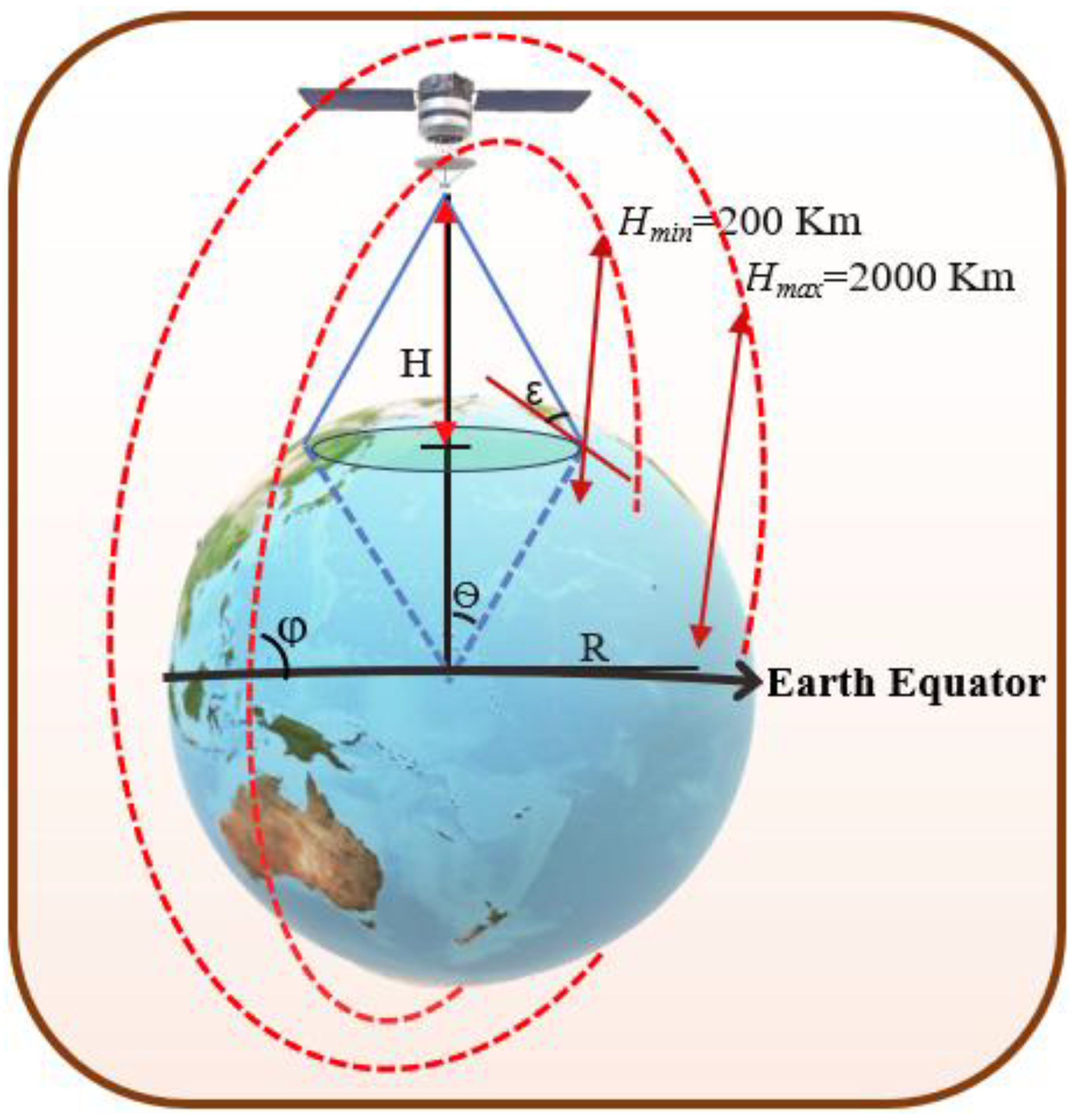
In particular, the LEO satellite constellation system has become an important zone for satellite internet providers. It is composed of separated orbits with altitudes of 200 km to 2000 km above ground, each orbit has specific number of satellites as can be shown in Figure 1. The satellite networks consist of K orbits which have the same 360⁰/(2✕K) angular separation from one another [7,8]. Each orbit has L satellites that only cross each other at the North and South poles. Satellites in the same orbit have an angular separation of 360⁰/L. Because the orbits are circular, the radii of satellites and their distances in the same orbit always remain constant. According to the second law of motion, the relation between the orbital velocity (V) to the orbital radius (r) can be expressed as:
where G is the universal constant of gravitation which equals 6.67259 x 10⁻¹¹ m3kg-1s-2, and M is the mass of the earth which equals 5.9736 x 1024 kg.
The mean orbital velocity for each satellite that is needed to maintain a stable low earth orbit is about 7.8 km/s, which translates to 28,000 km/h. However, this depends on the exact altitude of the satellite orbital. Therefore, the satellite velocity at a circular orbit with altitude of 200 km should be maintained at 7.79 km/s and reduced to 6.9 km/s at a circular with an altitude of 2000 km [9]. To provide continuous real-time services, satellites must overlap to cover the whole Earth's surface. The satellites are connected to each other via Inter-Satellite Links (ISLs) which have the ability to link satellites in the same or neighbor orbit. We refer to connect satellites in the same orbit as intra-orbital ISLs. ISLs may also be used to connect satellites into different orbits which are called inter-orbital ISLs. We presume that intra-orbital ISLs provide more reliability and persistence than inter-orbital ISLs. The horizontal paths of satellites in different orbits vary depending on the location of the satellites. For instance, if the satellites are over the equator, the horizontal distances are longest and shortest when they are over the boundaries of the polar regions. In contrast, the vertical paths of the satellites in the same orbit have fixed distances between them throughout the whole orbital connections.
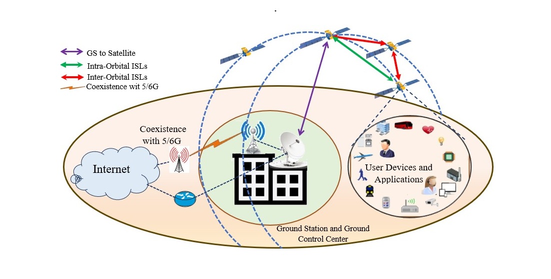
1.2. Operation of LEO Satellite Networks
The modern LEO satellite networks are divided into three parts: LEO space, ground station transceiver and user devices as illustrated in Figure 2. The LEO space consists of several orbitals with each contents fixed number of satellites which communicate using intra-orbital and inter-orbital ISL. Also, the satellites in each orbit can communicate with nearest ground stations that are distributed on the earth. Moreover, the ground segment consists of several ground stations (GSs) that are distributed on the earth to monitor, manage, and control the platforms and the signals sent by the satellites. In addition, the GS is connected to the partnering mobile network operators to provide the Internet services for the subscriber users. The mobile network operators might utilize LTE or 5/6G communication technology which depends on available infrastructure. Finally, the user segment which consists of user devices, wireless broadband routers and network applications which can serve smart mobile phones, iPad, tablet, PCs, servers, vehicles, IoT and sensors devices, etc. It is interesting to know that the GSs typically did not interact directly with the user segment, but only with the space segment.
The communication process in the modern LEO satellite networks is described as follows:
- Direct Connection: The user device connects directly to the satellites that cover the user device area.
- Satellite Relay: the satellites are equipped with an onboard LTE/5/6G modem (eNodeB) which acts like a cell tower in space that can receive from and transmit to user devices.
- Inter-Satellite Links (ISLs): the satellite uses laser ISLs to transmit the signal across the satellite network toward the satellite that is positioned over a GS.
- Ground Station Link: the signal is then downlinked to a GS connected to terrestrial networks that can provide internet backbone.
The trend of ubiquitous connectivity is the coexistence between LEO and 5G mobile communication network which becomes an increasingly pressing issue for satellite networks industrial companies. The coexistence between 5/6G and LEO will facilitate Internet access and voice services in mountains, sea, sky, islands and remote rural areas. However, several other obstacles must be overcome to guarantee that these technologies function properly without significantly degrading co-channel communications. For example, the interference impact from 5G user equipment and base station to LEO satellite signal, continuous adjustment of communication links, and unique routing challenges. As a result, the network topology frequently changed due to satellites movements which did not guarantee the reliability of the established connections in the network. Moreover, communication between LEO and ground stations experiences potential signal blockage due to tall buildings, and limited coverage area [10,11,12]. Thus, optimizing satellite orbital placement is required to create the optimal and reachable path between the source and the destination and to maintain reliable internet connectivity.
1.3. Problem Statement and Research Motivation
The presence of space debris and defunct satellites poses a constant threat to active satellites, as even small fragments can cause significant damage due to their high velocities. Furthermore, the absence of advanced technologies to retrieve or deorbit non-functional satellites and space debris makes a crucial challenge for space Internet provider companies to maintain safe orbital environments. The optimal satellite orbital placement ensures effective service delivery such as broadcasting, navigation, and internet connectivity. However, the satellite channel in the lower orbital placement suffers from rapid signal decay which is caused by atmospheric drag (gases), obstacles, and signal noise. The higher orbital placement causes higher latency (from 0.67ms at 200 Km to 6.7ms at 2000 Km) and signal decay and low signal strength. This means the highest satellite orbital placement provides unreliable Internet connectivity. The main motivation for this research is to review the optimizing satellite orbital placement which presents significant challenges. Factors such as orbital altitude, inclination, and spacing directly impact coverage, latency, and network resilience.
1.4. Research Contribution
The following contributions are reported in this research:
- It reviews the optimizing methods of satellite orbital placement and coverage for LEO networks. It highlights the main parameters that have been considered in increasing Internet connectivity, coverage area and reliability.
- It analyses the LEO orbital parameters that can mitigate the signal impairments and space debris, and it enhances the swath width for LEO satellite network.
- It suggests two solutions for satellite orbital placement and coverage optimization for LEO networks based on effective machine learning algorithms.
The rest of this paper is arranged as follows: Section 2 presents the related works on satellite orbital placement, coverage optimization and signal impairments. The analysis of satellite orbital placement and coverage optimization is explained in Sections 3. Also, Section 4 describes the suggested proposed solution and Section 5 explains the limitation and future works. Finally, Section 6 presents the conclusion and future work.
2. Related Works
In recent years, many companies of global Internet service provider deployed thousands of satellite constellations in LEO due to lower cost, smaller size, feasibility and global investment. Therefore, some companies support many researchers that have looked at various issues in satellite orbital placement including efficient LEO coverage area, signal strength quality and impairments, handover, latency, and number of satellites required to maintain Internet reliability and reachability. Commonly, there are several trends of optimizing solutions for satellite orbital placement that have been proposed in the literature as follows:
2.1. Related Work on Satellite Orbital Placement
The optimization of orbital placement in LEO satellite networks is essential for enhancing coverage, reducing latency, and ensuring network resilience. Several studies have been proposed in the literature to address the inherent challenges in designing efficient LEO constellations. Z.Shang [13] utilized deep reinforcement learning in optimizing satellite constellations, which significantly improved the communication speed and coverage efficiency in key regions such as underdeveloped areas and maritime routes, where deploying ground stations is challenging. The authors adjusted satellite orbital layers and densities to optimize the utilization of existing resources without increasing the total number of satellites. Also, F.S. Prol et al. [14] reviewed several requirements to build LEO positioning, navigation, and timing (PNT) system (LEO-PNT) including the transmitting signal between space segment, ground segment, and user segment. However, the authors have not recommended any desirable selections in every single aspect of the LEO-PNT system because of leakage of simulations in the current literature. G. Haibo et al. [15] used statistically analyzed in terms of number of orbitals, number of satellites in each orbital, and the inclinations angle to optimize LEO constellation for Global Navigation Satellite System (LeGNSS). The authors in [15] demonstrated that combining multiple Low Earth Orbit (LEO) satellite constellations with varying orbital inclinations results in a more uniform distribution of visible satellites across different latitudes. Moreover, Kaan et al. [16] presented overview of the LEO optimization methods for the three parts LEO system network including communication, navigation, and/or sensing applications. The authors in [16] compared various optimization methods in terms of their complexity, convergence characteristics, and feasibility. They presented the impact of orbital altitudes on latency and the significance of orbital plane positioning in determining coverage areas. Also, L. Jing et al. [17] designed two hybrid LEO constellations system based on NSGA-III optimization algorithm to enhance the BeiDou Satellite Navigation System (BDS). The proposed constellations in [17] reduced the number of satellites involved by more than 100. Furthermore, G.Junqi et al. [18] proposed a fast satellite selection algorithm for positioning in LEO constellation which used geometric method to select an optimal subset of satellites that meet the different numbers of observation satellites and is close to the optimal geometric configuration. Also, Kaan et al. [19] studied the design of the LEO-PNT constellation optimization, and the optimization approaches of the state-of-the-art for LEO satellite constellation including the effective metrics and their performance that must be considered for any LEO-PNT system design. For instance, studies have proposed methodologies that consider parameters such as orbital inclination, number of satellites, and orbital planes to enhance precise point positioning solutions. In addition, I.F.Ghoniem et al. [20] proposed a GNSS-LEO orbit optimization for Egypt and the Middle East region. The authors used two GNSS constellations data which are GPS with 29 satellites and GLONASS with 24 satellites. They studied more than hundred orbit cases for middle east region, and they found that the most optimal parameters for satellite placement are: altitude = 1500 km, inclination = 0°, initial value of mean anomaly = 330° and the other parameters are set to 0 values. The most related work is proposed by Yuta et al. [21] which suggested a metaheuristic optimization method for constellation determination using mathematical formulation, focusing on orbit requirements for interferometric applications. W. Xue et al. [22] studied the design of LEO navigation constellations while considering the task requirements of different stages of constellation deployment. They suggested solutions for performance degradation issues. The limitations of previous literature studies [13,14,15,16,17,18,19,20,21,22] are summarized in Table 1.
2.2. Related Work on Optimization of LEO Coverage Area
In this literature, several recent studies have used AI-driven optimization, beamforming techniques, constellation design, and resource allocation strategies to optimize the coverage areas in LEO satellite networks. The most related work is proposed by S. Cakaj [23,24] which developed the mathematical mode for LEO coverage belt and found that orbit attitude between 5633-8177 km and elevation angle between 2-10⁰ are achieved the wideness coverage area. Also, Z. Titus et al. [25] proposed a mathematical model for optimization of multi-altitude LEO satellite networks to achieve efficient coverage. The authors used metrics such as coverage probability, signal strength, interference levels, capacity, and quality of service to assess the performance of coverage area based on the Cox point process model and the optimized satellite deployment. The recent related work is proposed by Silvirianti et al. [26] which suggested a quantum adaptive learning (QAL) based on the advantage of quantum computing and adaptive learning as a potential solution for coverage optimization of stochastic geometry-based LEO satellite networks. Also, J. Shin et al. [27] proposed discontinuous regional coverage for LEO based on analytical constellations design, which determines the best inclination for a given constellation that maximizes the coverage for multi-ground regions. The authors in [27 developed optimal inclination search algorithm which considers both the region location and the satellite coverage range. Also, I.Lluch et al. [28] developed optimization approach for satellite-to-satellite coverage, and its analytical validation. The authors have shown that increasing the inter-satellite-link maximum range above 6,000 km does not lead to further coverage benefits at LEO altitude. Miyeon et al. [29] proposed mathematical analyses in terms of cluster area, LOS intensity, and SIR threshold for efficient coverage probability. The mathematical model proposed in [29] is aiding in reliable satellite cluster network design where satellites in the cluster area collaborate to serve users in mega-constellations. Peng Zong et al. [30] used a genetic algorithm to propose an optimized coverage of constellation satellite in one revisit and the regional coverage at defined latitude. The authors in [30] have shown that if the earth pole can be covered if the inclination angle of the satellites is more than 90 degrees. The optimal altitude can be used to provide revisit time between 90 to 130 minutes which means that satellites can cover the entire Earth in one revisit. Hassan et al. [31] proposed reconfigurable intelligent surfaces (RISs) within 6G sub-THz networks to maximize LEO satellite coverage which used to ultimately maximize end-to-end data rate through optimize network performance that includes satellite-RUE association, data packet routing in satellite constellations, RIS phase shift, and GBS transmit power. Also, Zhao et al. [32] proposed autonomous self-healing framework that captured the multi-objective of maximizing coverage performance, minimizing the total control effort for satellite constellation adaptation, and improved the resilience of the satellite constellation coverage for adversarial and non-adversarial attacks. The limitations of previous literature studies on optimization of LEO coverage area [23,24,25,26,27,28,29,30,31,32] are summarized in Table 2.
2.3. Related Work on LEO Orbital Signal Impairments
Several recent studies have addressed various challenges on signal impairments in LEO satellite networks which include jamming, interference, atmospheric effects, and hardware limitations, along with their proposed solutions and noted limitations focusing. Christina et al. [33]. surveyed receiver designs for LEO satellite signals, discussing challenges like Doppler shifts and signal attenuation, and exploring augmentation methods such as Satellite Timing and Location (STL) services. Also, Qian Ning et al. [34] proposed the system model of shadow fading and rain attenuation in the satellite downlink channel for LEO. The authors analyzed the application of Non-Orthogonal Multiple Access (NOMA) in LEO satellite communications under rain attenuation and fading, demonstrating improved ergodic capacity. The most related work was proposed by JIA Min et al. [35] who investigated inter-satellite link interference in large-scale LEO constellations, analyzing attenuation characteristics and time-frequency distributions. The authors in [35] used simulation to prove that there is a noticeable interference in the higher frequency links among large-scale LEO satellite constellation systems. Furthermore, Jiawei Liu et al. [36] proposed an approach for in-orbit calibration of the phase center offsets (PCOs) and code hardware delays of the LEO downlink navigation signal which enhanced signal accuracy. The finding of [36] was that increasing the number of tracking stations and processing periods can improve the formal precision of PCOs and hardware delay. Also, A.K Dwivedi et al. [37] studied two interference systems at the ground station to mitigate interference which are successive interference cancellation (SIC) and captured model (CM)-based decoding schemes. The average outage probability for the CM-based and SIC are derivative analytically under an extreme signal-to-noise ratio (SNR), which are utilized to optimize the system parameters for achieving a target outage probability. Moreover, R.Miteva et al. [38] presented two space weather phenomena which are geomagnetic storms and solar flares that have high impact on satellite operations. They discussed how sequences of geomagnetic disturbances, even if individually weak, can cumulatively lead to significant atmospheric drag, potentially resulting in satellite service disruptions or losses. Also, Radojkovic et al. [39] presented the impact of gamma-shadowed Ricean fading on the secrecy capacity of LEO satellite-to-ground communications and analyzed the secrecy performance of a LEO satellite and ground user (U) downlink in the presence of an eavesdropper, over Gamma-shadowed Ricean fading channels. In addition, Bassel F. Beidas [40] proposed an effective I/Q imbalance introduced by analog frequency-conversion circuits in LEO satellite systems which used a digital compensation algorithm with immunity to frequency offset. Ji Ma et al. [41] proposed a resilience measure for the LEO satellite networks which utilized uncertainty theory to define belief in instantaneous availability. The authors in [41] developed an uncertain satellite network evolution model which considered considering various impairments to describe the operating pattern of dynamic LEO and to estimate the resilience. Zhenghao Zhang [42] proposed a packet acquisition method using chirp signals to improve detection in weak signal environments and reduce peak-to-average power ratio. The limitations of previous literature studies [33,34,35,36,37,38,39,40,41,42] are summarized in Table 3.
3.0. Analysis of Satellite Orbital Placement and Coverage Optimization for LEO
The optimization of satellite orbital placement in LEO is fundamental for enhancing coverage area, reducing latency, and ensuring the efficiency of satellite networks. This section investigates the key parameters and methodologies involved in optimizing LEO satellite orbital placement.
3.1. Orbital Parameters and Their Impact
Several orbital parameters have been investigated in literature studies including altitude, latitude, inclination angle, elevation angle, swath width, packet latency, power of transmission, space debris, and SINR.
3.1.1. Satellite Coverage Area
The ground coverage area of a satellite can be assumed as a circle on the earth with the elevation angle (ε) between 0⁰ - 90⁰. The radius of the coverage area (D) for a satellite A which assumed a line-of-sight (LoS) constraint defined by ε can be calculated using the following equation [16,30]:
where= 6378 Km, and H is the orbital altitude. The coverage angle (Ѳ) of a satellite is an angle that specifies the area on the ground surface which allows the satellite to communicate with the devices on the ground surface at any given moment. The actual surface area that is covered by satellite A (the area of a spherical cap) can be calculated as follows:
Since the radius is smaller compared to the , Equation (3) can be approximated to:
Equation (4) facilitates optimizing communication visibility, and Internet reachability. However, satellite coverage can be influenced by factors such as atmospheric attenuation, obstacles blocking transmission, and signal impairment. It is interesting to know that higher orbital altitudes (H) will increase the coverage area but may reduce signal strength and increase latency. Also, higher ε will reduce the coverage area but improve signal quality by reducing atmospheric interference.
Figure 3.
Orbital Parameters for LEO Satellite Networks.
3.1.2. Satellite Swath Width
The LEO orbital placement can be used in imaging, sensing, and observation planning. For this purpose, the satellites are equipped with sensors or high-resolution cameras.
The inclination angle (φ) determines the latitude limits of the orbit which specifies the relevant area for overall orbital coverage. Moreover, the φ with 60° to 120° is considered as a polar orbit which enables the satellite to be able to view a larger fraction of the Earth. As shown in Figure 4, the swath width refers to the strip of the Earth's surface from which geographic data is collected by a satellite. It is the width of the light strip on the surface below as the flashlight moves. The nadir line is a straight vertical line downwards and perpendicular to the Earth's surface. Also, the anglein radian is the angle measured at the satellite which is placed between the nadir line and the line that has been drawn to the left edge of the camera/sensor field of view (FOV). The equation of swath width (SW) in curved earth model can be derived as follows [43]:
While the coverage area Equation (2) is used to measure communication visibility, the swath width Equation (5) is used to measure the imaging and observation planning.
3.1.3. LEO Space Debris
Space debris refers to any unused objects that are orbiting earth and were created from defunct satellites, spent rocket stages, fragments from explosions or collisions, and even paint flecks. In fact, the danger of space debris lies in high velocities of objects in LEO (up to 28,000 km/h) which means that even small pieces of debris can cause significant damage to operational satellites or spacecraft, which is leading to loss of function or even catastrophic breakups. This creates a cascading effect known as Kessler Syndrome which concludes that collisions generate more debris and increase the likelihood of further collisions. As a result, space debris presents a considerable risk to both present and forthcoming space operations which potentially affects critical services such as telecommunications, global positioning systems, earth surveillance, and manned space exploration. LEO is particularly crowded with two types of debris: tracked objects (>10 cm) and untracked objects (<10 cm). As of early 2025, the number of tracked objects in LEO is approximately 22500 which includes 11700 operational and nonoperational payloads, 950 rocket bodies, 7750 debris fragments, and 2100 unknown objects. Moreover, the number of untracked objects is divided into three categories: 1-10 cm is approximately 600000 pieces, 1mm-1cm is about 10 million pieces, and less than 1mm is more than trillion pieces [44,45,46,47,48]. As can be seen in Figure 5 and Table 4, the most congested debris area in LEO space is between 500 and 1000 km with both tracked and untracked objects. The debris area that is located between 800 and 1000 km is called congest LEO belt. In contrast, the two LEO space areas have lower debris density which are 200-500 km, and 1500-2000. However, the first area has frequent orbital decay due to atmospheric drag. The second area has long delays (10 times longer delays) compared to the first area.
| Altitude Range (km) | Tracked Debris (>10 cm) | Estimated Untracked Debris (1 mm–10 cm) | Description |
| 200–500 | ~1,200 | ~60,000 | Lower density; frequent orbital decay due to atmospheric drag. Debris typically re-enters within years. |
| 500–800 | ~4,500 | ~150,000 | Moderate density; long-lived orbits. Popular for remote sensing missions. |
| 800–1,000 | ~6,800 | ~200,000 | Densest zone, called “congested LEO belt.” Site of several breakup events (e.g., Iridium-Cosmos collision). |
| 1,000–1,500 | ~3,000 | ~80,000 | Includes old satellites and upper stages. Low drag means debris remains for centuries. |
| 1,500–2,000 | ~1,000 | ~30,000 | Sparse compared to lower LEO, but debris is persistent due to low atmospheric influence. |
3.1.4. LEO Signal Impairments
Signal impairment is the degradation of a satellite communication signal due to signal distortion, noise, interference, and attenuation. Managing and reducing signal impairment is a primary challenge due to crowded satellite environment and share limited frequency bands in LEO communication system. In addition, if signal impairment is too strong, a satellite ground station or user terminal cannot correctly interpret the data from the satellite, leading to communication failure. Furthermore, signal impairments can come from various space and ground sources:
- Intra-System Interference: Beams from adjacent satellites can overlap which causes interference for users on the ground.
- Inter-System Interference: Interference from satellites in different LEO constellations or from satellites in higher orbits (MEO/GEO) that use adjacent frequency bands.
- Terrestrial Interference: Signals from ground-based systems such as 5G towers, Wi-Fi networks, and microwave signals are a major source of interference.
- Space Weather: Solar flares and geomagnetic storms cause signal attenuation or noise.
- Intentional Interference (Jamming): Malicious attempts to transmit powerful signals at a satellite to disrupt its communication link.
- Multipath and Doppler Effects: Due to fast satellite movement and terrain-based signal reflection.
3.1.5. LEO Signal Impairments
Signal impairment is the degradation of a satellite communication signal due to signal distortion, noise, interference, and attenuation. Managing and reducing signal impairment is a primary challenge due to crowded satellite environment and share limited frequency bands in LEO communication system. In addition, if signal impairment is too strong, a satellite ground station or user terminal cannot correctly interpret the data from the satellite, leading to communication failure. Furthermore, signal impairments can come from various space and ground sources:
- Intra-System Interference: Beams from adjacent satellites can overlap which causes interference for users on the ground.
- Inter-System Interference: Interference from satellites in different LEO constellations or from satellites in higher orbits (MEO/GEO) that use adjacent frequency bands.
- Terrestrial Interference: Signals from ground-based systems such as 5G towers, Wi-Fi networks, and microwave signals are a major source of interference.
- Space Weather: Solar flares and geomagnetic storms cause signal attenuation or noise.
- Intentional Interference (Jamming): Malicious attempts to transmit powerful signals at a satellite to disrupt its communication link.
- Multipath and Doppler Effects: Due to fast satellite movement and terrain-based signal reflection.
When a satellite signal is affected by any overmentioned signal impairment, it leads to several negative consequences for the user and the network. For example, it reduced network data rate (Throughput), increased connection bit error rate (BER) and latency, and dropped connections between satellite and receiver. The primary metric used to measure the quality and clarity of a communication signal in the presence of interference and noise is the Signal-to-Interference-plus-Noise Ratio (SINR) which can be formulated as [49,50,51]:
where d is the distance between the satellite and the receiver which could be another satellite or ground station or user devices, d0 is the reference distance, is the received signal, presents the total multi-path interference, N is the total noises that affect the received signal, and β is the path loss exponent which reflects the signal decays over distance in specific propagation environment. Xσ is the gaussian distributed random variable in (dB). CI is the overlapping factor between 0 and 1 and it depends on the spectral properties (channel width, distance of inter-channel spectral, and spectral mask) and the separation from interferer channel i.
4.0. Discussion of Satellite Orbital Placement Proposed Solutions
The suggested satellite placement solution considers the overmentioned problems and it selects the optimal affective coverage parameters. In order to overcome space debris, signal impairments, and frequent orbital decay, the optimal placement solution should use an AI algorithm that can manage different variables and consider all affective challenges.
4.1. Satellite Orbital Placement Proposed Solution
This research suggests using machine learning (ML) algorithms to estimate the optimal satellite orbital placement based on overmentioned analysis parameters. Among ML algorithms, distributed reinforcement learning (DRL) can accept multifunction inputs and provide optimal target output. The rewards function can be determined using multivariable parameters such as SINR, end-to-end delay, optimal altitude, number of tracked and untracked debris, etc. The suggested satellite orbital placement model based on DRL should perform the following steps:
-
Step 1: Select affective placement parameters.
- The most affective parameters in satellite placement are SINR, end-to-end delay, optimal altitude, number of tracked and untracked debris, etc.
-
Step 2: Initialize the matrix Q of DRL.
- The Q-matrix must be constructed and initialized to 0. The columns represent all possible actions while the rows represent the states for each action.
-
Step 3: Choose and perform action.
- For each episode, a random initial state and possible action are selected by the agent to go to the next state. After that, the maximum Q value for the next state is estimated as:where α represents the learning rate, γ is the discount factor, is the new value of Q, is the current Q value, and is the maximum predicted rewards by given new states and possible actions.
-
Step 4: Reward estimation.
- The reward function is calculated based on R (State, Action(selected parameters)).
-
Step 5: Q-Learning evaluation.
- The function Q(State, Action) should be maximized, and the Q-Table should be updated until the learning is stopped.
-
Step 6: Debris Avoidance.
- The suggested proposed algorithm should utilize a collision avoidance system that autonomously detects potential collisions with other satellites or debris. Consequently, AI system with advance detection systems should be applied for each satellite to perform real-time orbital adjustments.
4.2. Coverage Optimization Proposed Solution
The dynamic values of inclination angle, elevation angle, and swath width for each satellite in the same orbital should be utilized to suggest optimization function. Furthermore, the estimation of satellite orbital placement is recommended to be involved in the coverage area optimization because it has correlation with inclination angle, elevation angle, and swath width calculation. The suggested algorithm follows the following steps:
-
Step 1: Obtain value of Satellite Orbital Placement.
- The latitude (H) should be estimated from previous algorithm of orbital placement because it is an important parameter in coverage area equation.
-
Step 2: Determine the weightage for each involved parameter.
- The satellite should autonomously adjust values of inclination angle, elevation angle, and swath width. The number of satellites in each orbit is determined to reliably cover the whole ground. Based on the effectiveness of each parameter, the weightage of each one of them is estimated.
-
Step 3: Use optimization function.
- One of the real-time optimization algorithms such heuristic, and metaheuristics should be used to obtain the optimal value of satellite coverage area. The metaheuristics algorithms perform better optimization, including genetic algorithms, particle swarm optimization, and simulated annealing, ant colony optimization.
-
Step 4: Communication evaluation.
- The link quality and reliable internet connectivity should be evaluated for each coverage optimization selection.
-
Step 5: Select optimal coverage area parameters.
- After evaluation of each selection, the most optimal value of inclination angle, elevation angle, and swath width are determined based on the latitude value that is estimated in Equations (3) and (5).
5.0. Limitations and Future Works
Although this survey paper was carefully presenting a comprehensive review on satellite orbital placement and coverage optimization for LEO satellite networks, there were some unavoidable limitations. The space debris cannot be total avoidance, but it can mitigate the accidence with the active satellites. The very fast untracked debris objects can cause many satellites to crash due to accidents with those objects which leads to stopping internet connectivity in some coverage area. It is commonly agreed that the lower orbital has strong signal decay due to atmospheric drag, and the higher orbital has long signal latency.
6.0. Conclusion
This paper presents a comprehensive review of satellite orbital placement and coverage optimization for LEO satellite networks. It introduces the challenges of current internet connectivity and space debris objects. Also, it proposed solutions for both satellite orbital placement based on DRL algorithm and coverage optimization based on metaheuristics algorithm. The suggested solution utilized multi-input variables such as SINR, end-to-end delay, optimal altitude, inclination angle, elevation angle, and swath width. Furthermore, this survey proposes concrete guidelines for LEO satellites placement such as orbital altitude, inclination, and inter-satellite spacing that maximize internet coverage and reliability. This paper also presents the current methods and identifies the key design parameters which provide a framework for developing globally optimal LEO constellations. Future work will extend this framework to incorporate adaptive debris-avoidance strategies and enabling satellites to adjust their orbits in real time based on collision risk and network performance metrics.
Author Contributions
Conceptualization, Adel.A., A.ALZAHRANI ,and O.M.; methodology, Adel.A.; software, Adel.A.; validation, A. ALZAHRANI., and O.M.; formal analysis, A. ALZAHRANI; investigation, O.M.; resources, Adel.A.; data curation, O.M.; writing—original draft preparation, Adel.A.; writing—review and editing, Adel.A, and A. ALZAHRANI.; visualization, O.M.; supervision, Adel.A.; project administration, Adel.A.; funding acquisition, Adel.A.
Funding
This Project was funded by KAU Endowment (WAQF) at King Abdulaziz University, Jeddah, under grant no. (WAQF:180-830-2024). The authors, therefore, acknowledge with thanks WAQF and the Deanship of Scientific Research (DSR) for technical and financial support.
Data Availability Statement
Not applicable.
Acknowledgments
This Project was funded by KAU Endowment (WAQF) at King Abdulaziz University, Jeddah, under grant no. (WAQF:180-830-2024). The authors, therefore, acknowledge with thanks WAQF and the Deanship of Scientific Research (DSR) for technical and financial support.
Conflicts of Interest
The authors declare no conflict of interest
References
- K. Çelikbilek, E. S. K. Çelikbilek, E. S. Lohan, and J. Praks (2024), Optimization of a LEO-PNT Constellation: Design Considerations and Open Challenges, Int J Satell Commun Network. 2024;01-16. [CrossRef]
- Prol FS, Bhuiyan MZH, Kaasalainen S, et al. Simulations of Dedicated LEO-PNT Systems for Precise Point Positioning: Methodology, Parameter Analysis, and Accuracy Evaluation. to appear in IEEETransactions on AerospaceandElectronic Systems 2024: 8. [CrossRef]
- Liu, J. , et al.: Design optimisation of low earth orbit constellation based on BeiDou Satellite Navigation System precise point positioning. IET Radar Sonar Navig. 16(8), 1241–1252 (2022). [CrossRef]
- Nardin A, Dovis F, Fraire JA. Empowering the Tracking Performance of LEO-Based Positioning by Means of Meta Signals. IEEE Journal of Radio Frequency Identification 2021; 5(3): 244–253. [CrossRef]
- M. Frąckiewicz, Sky-Fi Revolution: How Starlink Is Reshaping Global Internet Access, access on May 2025.
- Wu, Z.; Ni, S.; Xiao, W.; Li, Z.; Liu, H. Study on the Feasibility and Performance Evaluation of High-Orbit Spacecraft Orbit Determination Based on GNSS/SLR/VLBI. Remote Sens. 2024, 16, 4214. [Google Scholar] [CrossRef]
- Page, Pranav S., Kaustubh S. Bhargao, Hrishikesh V. Baviskar, and Gaurav S. Kasbekar. "Distributed probabilistic congestion control in LEO satellite networks." In 2023 15th International Conference on COMmunication Systems & NETworkS (COMSNETS), pp. 335-339. IEEE, 2023. [CrossRef]
- Ekici, Eylem, Ian F. Akyildiz, and Michael D. Bender. "Datagram routing algorithm for LEO satellite networks." In Proceedings IEEE INFOCOM 2000. Conference on Computer Communications. Nineteenth Annual Joint Conference of the IEEE Computer and Communications Societies (Cat. No. 00CH37064), vol. 2, pp. 500-508. IEEE, 2000. [CrossRef]
- The many locations for space science missions, Satellite Orbits, https://www.teledyne, access on April 2025.
- Wang, Ruibo, Mustafa A. Kishk, and Mohamed-Slim Alouini. "Stochastic geometry-based low latency routing in massive LEO satellite networks." IEEE Transactions on Aerospace and Electronic Systems 58, no. 5 (2022): 3881-3894. [CrossRef]
- Guo, Jianming, David Rincon, Sebastia Sallent, Lei Yang, Xiaoqian Chen, and Xianqi Chen. "Gateway placement optimization in LEO satellite networks based on traffic estimation." IEEE Transactions on Vehicular Technology 70, no. 4 (2021): 3860-3876. [CrossRef]
- G. Fontanesi, F. G. Fontanesi, F. Ortíz, E. Lagunas, V. Monzón Baeza, M. Vázquez, J.A. Vásquez-Peralvo, M. Minardi, H.-N. Vu, P. Jubba Honnaiah, C. Lacoste, Y. Drif, T.S. Abdu, G. Eappen, J. Rehman, L.M. García-Socorrás, W.A. Martins, P. Henarejos, H. Al-Hraishawi, J.C. Merlano Duncan, T.X. Vu, and S. Chatzinotas, "Artificial Intelligence for Satellite Communication and Non-Terrestrial Networks: A Survey," 2023. [CrossRef]
- Shang, Zixia. "Towards Future Communication: AI-Based Satellite Constellation Orbit Optimization and Design for Underserved Areas." Authorea Preprints (2025).
- Prol, Fabricio S., R. Morales Ferre, Zainab Saleem, Petri Välisuo, Christina Pinell, Elena Simona Lohan, Mahmoud Elsanhoury et al. "Position, navigation, and timing (PNT) through low earth orbit (LEO) satellites: A survey on current status, challenges, and opportunities." IEEE access 10 (2022): 83971-84002. [CrossRef]
- Ge, Haibo, Bofeng Li, Liangwei Nie, Maorong Ge, and Harald Schuh. "LEO constellation optimization for LEO enhanced global navigation satellite system (LeGNSS)." Advances in Space Research 66, no. 3 (2020): 520-532. [CrossRef]
- Çelikbilek, Kaan, Zainab Saleem, Ruben Morales Ferre, Jaan Praks, and Elena Simona Lohan. "Survey on optimization methods for LEO-satellite-based networks with applications in future autonomous transportation." Sensors 22, no. 4 (2022): 1421. [CrossRef]
- Liu, Jing, Jinming Hao, Yan Yang, Zheyu Xu, Weiping Liu, and Renzhe Wu. "Design optimisation of low earth orbit constellation based on BeiDou Satellite Navigation System precise point positioning." IET radar, sonar & navigation 16, no. 8 (2022): 1241-1252. [CrossRef]
- Guo, Junqi, Yang Wang, Xingxiang Xie, and Chenyang Sun. "A fast satellite selection algorithm for positioning in LEO constellation." Advances in Space Research 73, no. 1 (2024): 271-285. [CrossRef]
- Çelikbilek, Kaan, Elena Simona Lohan, and Jaan Praks. "Optimization of a LEO-PNT Constellation: Design Considerations and Open Challenges." International Journal of Satellite Communications and Networking (2025). [CrossRef]
- Ghoniem, Ibrahim Fouad, Ashraf El-Kutb Mousa, and Gamal El-Fiky. "GNSS-RO LEO satellite orbit optimization for Egypt and the Middle East region." Alexandria Engineering Journal 59, no. 1 (2020): 389-397. [CrossRef]
- Imoto, Yuta, Satoshi Satoh, Toshihiro Obata, and Katsuhiko Yamada. "Optimal constellation design based on satellite ground tracks for Earth observation missions." Acta Astronautica 207 (2023): 1-9.
- Xue, W.; Hu, M.; Ruan, Y.; Wang, X.; Yu, M. Research on Design and Staged Deployment of LEO Navigation Constellation for MEO Navigation Satellite Failure. Remote Sens. 2024, 16, 3667. [Google Scholar] [CrossRef]
- Cakaj, Shkelzen. "The coverage belt for low earth orbiting satellites." Proc. 39th Int. Convent. Info. Commun. Technol., Electron. Microelectron.(ICICTEM), Opatija, Croatia: 554-557, 2016.
- Cakaj, Shkelzen, Bexhet Kamo, Algenti Lala, and Alban Rakipi. "The coverage analysis for low earth orbiting satellites at low elevation. International Journal of Advanced Computer Science and Applications 5, no. 6.:6-10, 2014. [CrossRef]
- Zhu, Titus Gramacy, Shi-soon Solosa, and Periera Maniani. "Modeling and optimization of multi-altitude leo satellite networks using cox point processes: Towards efficient coverage and performance analysis." International Journal of Enterprise Modelling 17, no. 1 (2023): 35-44.
- Silvirianti, X. , and Georges Kaddoum. "Quantum Adaptive Learning for Coverage Optimization in LEO Satellite Network.", TechRxiv., Authorea Preprints. , 2025. 19 March. [CrossRef]
- Shin, Jinyoung, Sang-Young Park, Jihae Son, and Sung-Chan Song. "Design of regional coverage low earth orbit (LEO) constellation with optimal inclination." Journal of Astronomy and Space Sciences 38, no. 4 (2021): 217-227. [CrossRef]
- Lluch, Ignasi, and Alessandro Golkar. "Satellite-to-satellite coverage optimization approach for opportunistic inter-satellite links." In 2014 IEEE Aerospace Conference, pp. 1-13. IEEE, 2014.
- Lee, Miyeon, Sucheol Kim, Minje Kim, Dong-Hyun Jung, and Junil Choi. "Analyzing downlink coverage in clustered low Earth orbit satellite constellations: A stochastic geometry approach." IEEE Transactions on Communications (2025). [CrossRef]
- Zong, Peng, and Saeid Kohani. "Optimal satellite LEO constellation design based on global coverage in one revisit time." International Journal of Aerospace Engineering 2019, no. 1 (2019): 4373749. [CrossRef]
- Hassan, Sheikh Salman, Yu Min Park, Yan Kyaw Tun, Walid Saad, Zhu Han, and Choong Seon Hong. "SpaceRIS: LEO satellite coverage maximization in 6G sub-THz networks by MAPPO DRL and whale optimization." IEEE Journal on Selected Areas in Communications (2024). [CrossRef]
- Zhao, Yuhan, and Quanyan Zhu. "Autonomous and resilient control for optimal leo satellite constellation coverage against space threats. arXiv:2203.02050 (2022).
- Pinell, Christina, Fabricio S. Prol, M. Zahidul H. Bhuiyan, and Jaan Praks. "Receiver architectures for positioning with low earth orbit satellite signals: a survey." EURASIP Journal on Advances in Signal Processing 2023, no. 1 (2023): 60. [CrossRef]
- Ning, Qian, Xinjing Yang, Bingcai Chen, and Xinzhi Zhou. "The performance analysis of NOMA in LEO satellite rain attenuation and fading hybrid channel." International Journal of Satellite Communications and Networking 40, no. 4 (2022): 256-267. [CrossRef]
- JIA Min,MENG Shiyao,GUO Qing,GU Xuemai. "Analysis of inter-system interference of large-scale LEO satellite constellation." Journal of Terahertz Science and Electronic Information Technology 20, no. JIA Min,MENG Shiyao,GUO Qing,GU Xuemai. "Analysis of inter-system interference of large-scale LEO satellite constellation." Journal of Terahertz Science and Electronic Information Technology 20, no. 1 (2022): 34-39.
- Liu, Jiawei, Kan Wang, Ahmed El-Mowafy, and Xuhai Yang. "PCO and hardware delay calibration for LEO satellite antenna downlinking navigation signals." Measurement Science and Technology 35, no. 8 (2024): 086314. [CrossRef]
- Dwivedi, Ayush Kumar, Sachin Chaudhari, Neeraj Varshney, and Pramod K. Varshney. "Performance analysis of LEO satellite-based IoT networks in the presence of interference." IEEE Internet of Things Journal 11, no. 5 (2023): 8783-8799. [CrossRef]
- Miteva, R.; Samwel, S.W.; Tkatchova, S. Space Weather Effects on Satellites. Astronomy 2023, 2, 165–179. [Google Scholar] [CrossRef]
- Radojkovic, I.; Anastasov, J.; Milic, D.N.; Ivaniš, P.; Djordjevic, G.T. Secrecy Analysis of LEO Satellite-to-Ground Station Communication System Influenced by Gamma-Shadowed Ricean Fading. Electronics 2025, 14, 293. [Google Scholar] [CrossRef]
- Beidas, Bassel F. "Low cost per bit for LEO satellite systems: radio-frequency impairments compensation.", Non-Geostationary Satellite Communications Systems, Chapter 5, pp.: 89-111, 2022.
- Ma, J.; Kang, R.; Li, R.; Zhang, Q.; Liu, L.; Wang, X. Uncertainty Theory-Based Resilience Analysis for LEO Satellite Communication Systems. Symmetry 2022, 14, 1568. [Google Scholar] [CrossRef]
- Zhang, Zhenghao. "ChirpPair: packet acquisition in uncoordinated access channels of Low Earth Orbit (LEO) satellite networks." EURASIP Journal on Wireless Communications and Networking 2024, no. 1 (2024): 47. [CrossRef]
- Sun, Y.; Rao, P.; Hu, T. Parameter Design and Performance Evaluation of a Large-Swath and High-Resolution Space Camera. Sensors 2021, 21, 4106. [Google Scholar] [CrossRef] [PubMed]
- "3 DEBRIS POPULATION DISTRIBUTION." National Research Council. 1995. Orbital Debris: A Technical Assessment. Washington, DC: The National Academies Press. [CrossRef]
- National Academies of Sciences, Engineering, and Medicine. 1995. Orbital Debris: A Technical Assessment. Washington, DC: The National Academies Press. [CrossRef]
- ESA’S ANNUAL SPACE ENVIRONMENT REPORT, https://sdup.esoc.esa.int/discosweb/statistics/, https://www.sdo.esoc.esa.int/environment_report/Space_Environment_Report_latest.pdf, accessed on May 2025.
- Astromaterials Research & Exploration Science, NASA ORBITAL DEBRIS PROGRAM OFFICE, https://orbitaldebris.jsc.nasa.gov/faq/, accessed on May 2025.
- SPACE SAFETY, About space debris, https://www.esa.int/Space_Safety/Space_Debris/About_space_debris, accessed on May 2025.
- Ahmed, A.A.; Malebary, S.J.; Ali, W.; Barukab, O.M. Smart Traffic Shaping Based on Distributed Reinforcement Learning for Multimedia Streaming over 5G-VANET Communication Technology. Mathematics 2023, 11, 700. [Google Scholar] [CrossRef]
- Ahmed, Adel A. "An effective handover management based on SINR and software-defined network over urban vehicular ad hoc networks." Transactions on Emerging Telecommunications Technologies 30, no. 12 (2019): e3787. [CrossRef]
- Ahamed, A. A real-time routing protocol with adaptive traffic shaping for multimedia streaming over next-generation of Wireless Multimedia Sensor Networks. Pervasive Mob Comput. 2017; 40: 495-511.
Figure 1.
LEO Satellite Constellation.
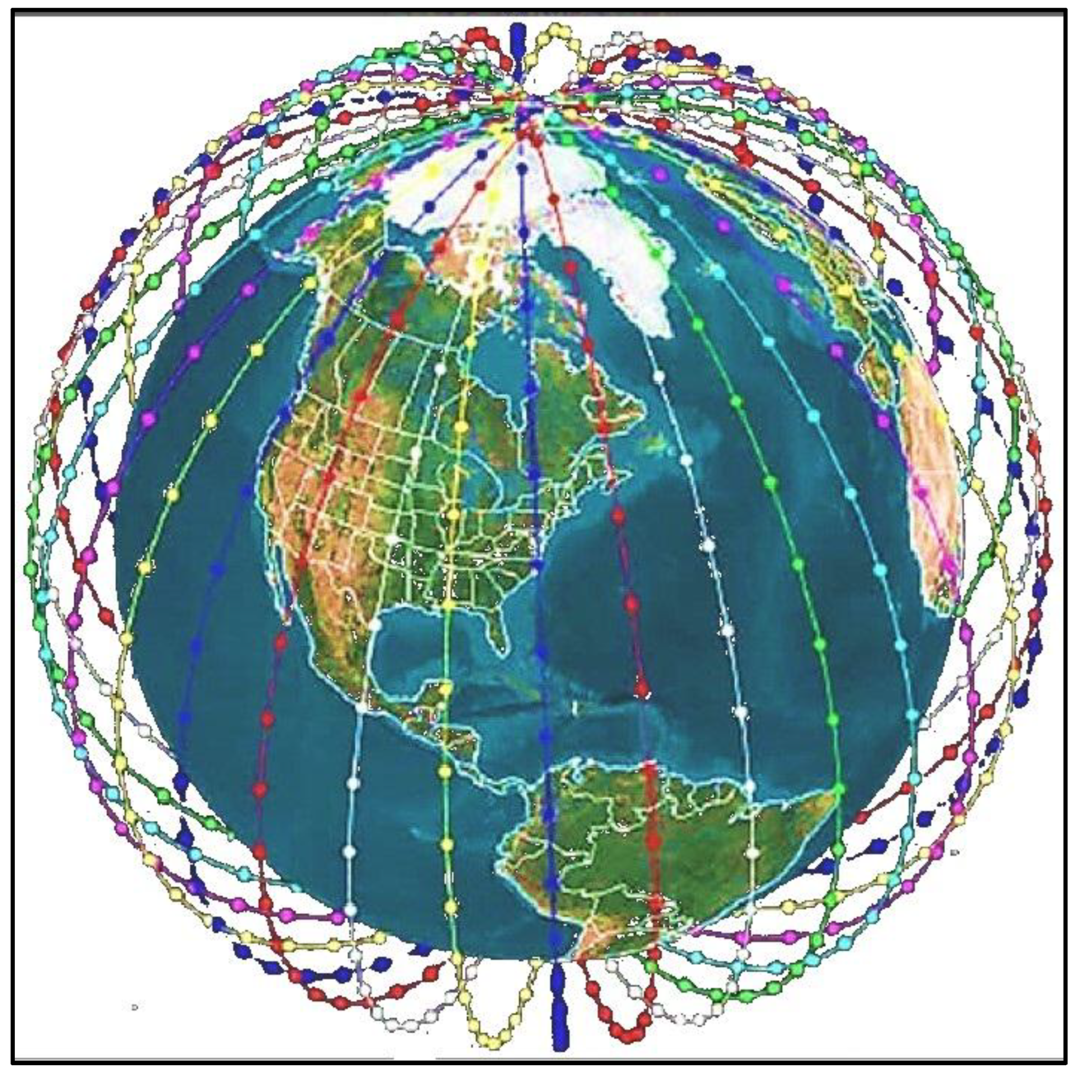
Figure 2.
Operation of Modern LEO Satellite Networks.
Figure 4.
Swath width for camera/sensor in the satellite.
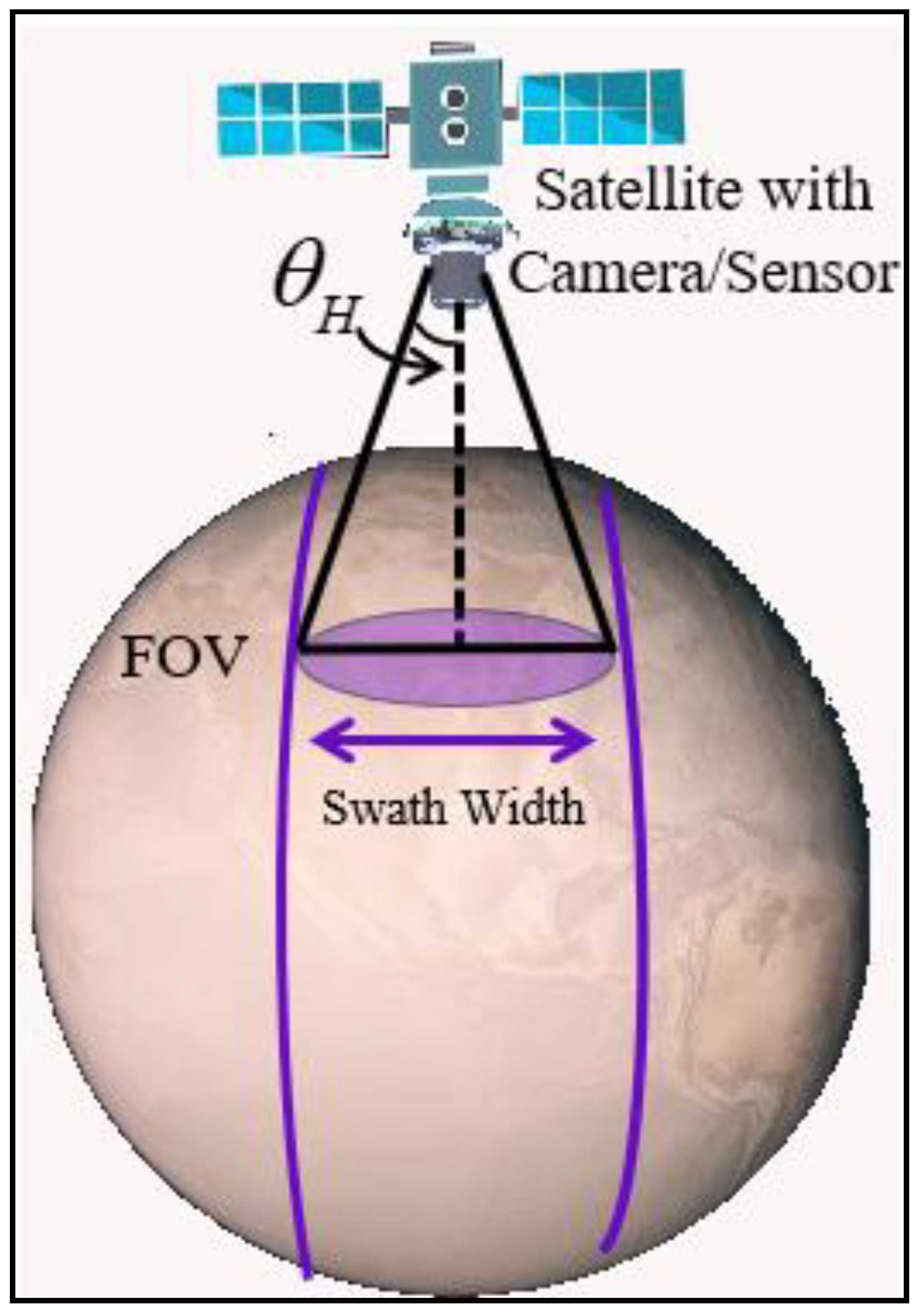
Figure 5.
LEO space debris.
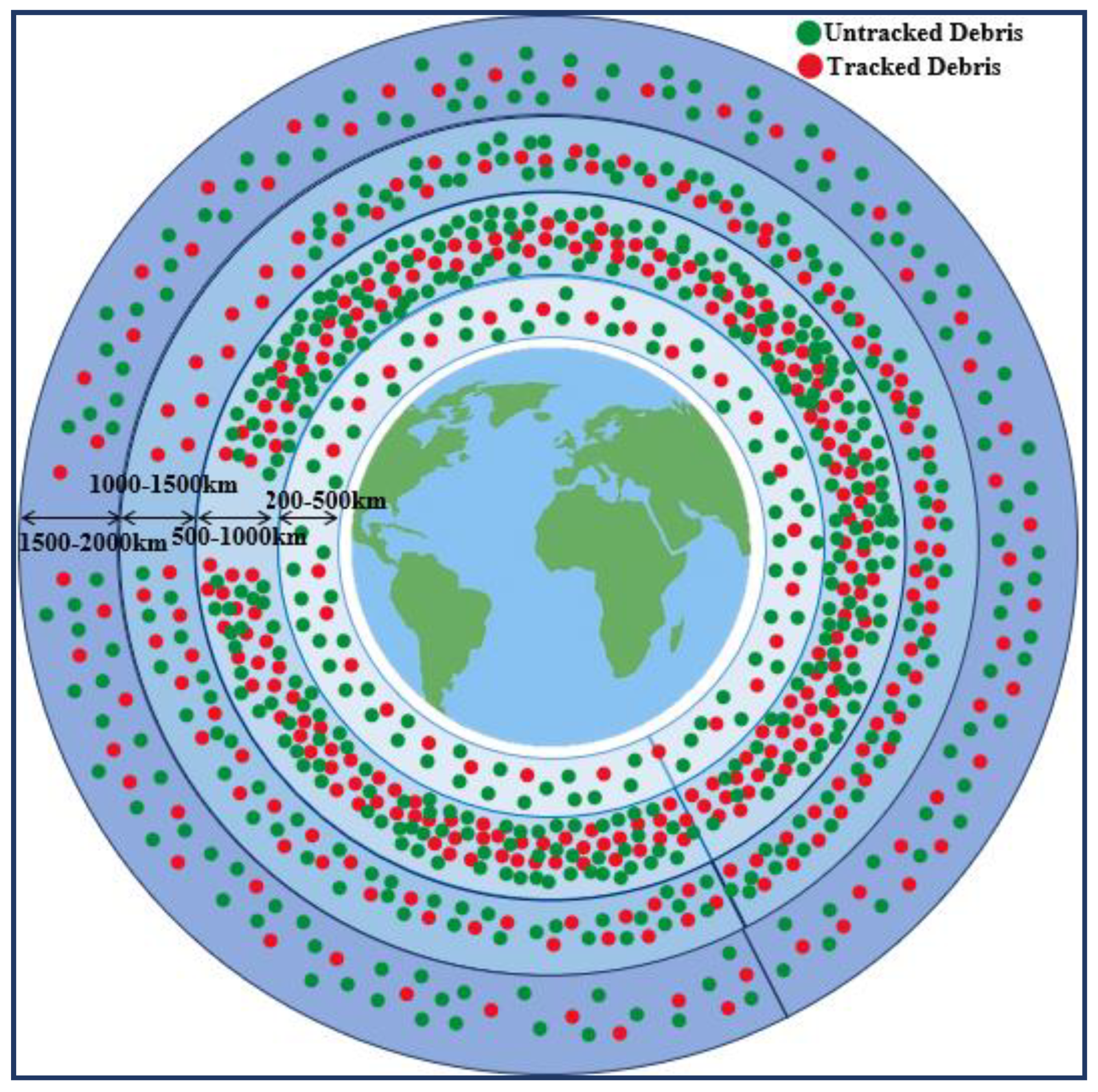

Table 1.
Summary of Satellite Orbital Placement.
| Research Work | Publish Year | Short Description | Limitation |
|---|---|---|---|
| Z. Shang [13] | 2024 | Utilized deep reinforcement learning for optimizing satellite constellations, enhancing communication speed and coverage in challenging regions. | Focused on specific regions; generalizability to other areas not addressed. |
| F.S. Prol et al. [14] | 2023 | Reviewed requirements for building LEO-PNT systems, including signal design and system segments. | Lacked clear recommendations due to limited simulations in existing literature. |
| G. Haibo et al. [15] | 2020 | Analyzed orbital parameters to optimize LEO constellations for GNSS, promoting uniform satellite distribution. | Did not consider dynamic environmental factors affecting satellite visibility. |
| Kaan et al. [16] | 2022 | Presented an overview of LEO optimization methods across various applications and system segments. | Comparative analysis may not cover all emerging optimization techniques. |
| L. Jing et al. [17] | 2021 | Applied NSGA-III algorithm to design hybrid LEO constellations, reducing satellite count for BeiDou enhancement. | Potential trade-offs in coverage and redundancy are not fully explored. |
| G. Junqi et al. [18] | 2023 | Proposed a fast satellite selection algorithm using geometric methods for optimal positioning. | Performance under real-world signal conditions not extensively validated. |
| Kaan et al. [19] | 2023 | It studied LEO-PNT constellation design, evaluating optimization approaches and performance metrics. | May require further empirical validation for specific application scenarios. |
| I.F. Ghoniem et al. [20] | 2020 | Proposed GNSS-LEO orbit optimization for Egypt and the Middle East, analyzing over 100 orbit cases. | Focused on a specific geographic region; applicability to other regions uncertain. |
| Yuta et al. [21] | 2010 | Suggested a metaheuristic optimization method for constellation design in interferometric applications. | Limited by the computational complexity of metaheuristic approaches. |
| W. Xue et al. [22] | 2024 | It studied LEO navigation constellation design considering deployment stages and task requirements. | Solutions for performance degradation issues need further testing. |
Table 2.
Summary of Optimization of LEO Coverage Area.
| Research Work | Publish Year | Short Description | Limitation |
|---|---|---|---|
| S. Cakaj [23,24] | 2016, 2014 | Developed a mathematical model for LEO coverage belt, identifying optimal orbital altitudes (5633–8177 km) and elevation angles (2°–10°) for maximum coverage area. | Models may not account for dynamic environmental factors or real-time operational constraints. |
| Z. Titus et al. [25] | 2023 | Proposed a mathematical model using Cox point processes to optimize multi-altitude LEO satellite networks, assessing performance via coverage probability, signal strength, interference levels, capacity, and quality of service. | The model's complexity may pose challenges for real-time implementation and scalability. |
| Silvirianti et al. [26] | 2025 | Suggested a Quantum Adaptive Learning (QAL) approach leveraging quantum computing and adaptive learning for coverage optimization in stochastic geometry-based LEO satellite networks. | Quantum computing applications are still emerging; practical implementation may be limited by current technological capabilities. |
| J. Shin et al. [27] | 2021 | Proposed an analytical constellation design for discontinuous regional coverage, introducing an optimal inclination search algorithm to maximize coverage for specific ground regions. | Focused on regional coverage may not address global coverage requirements or dynamic reconfiguration needs. |
| I. Lluch et al. [28] | 2014 | Introduced an optimization approach for satellite-to-satellite coverage, demonstrating that increasing inter-satellite link range beyond 6,000 km yields diminishing returns at LEO altitudes. | The study may not consider advancements in inter-satellite communication technologies or varying orbital dynamics. |
| Miyeon et al. [29] | 2025 | Conducted mathematical analysis on cluster area, Line-of-Sight (LOS) intensity, and Signal-to-Interference Ratio (SIR) thresholds to enhance coverage probability in satellite cluster networks. | The model may require extensive data for accurate predictions and might not adapt well to rapidly changing network conditions. |
| Peng Zong et al. [30] | 2019 | Utilized a genetic algorithm to optimize constellation satellite coverage in one revisit, focusing on regional coverage at defined latitudes and demonstrating that inclinations above 90° can cover Earth's poles. | The approach may not fully address the trade-offs between coverage frequency and resource constraints. |
| Hassan et al. [31] | 2024 | Proposed the integration of Reconfigurable Intelligent Surfaces (RISs) within 6G sub-THz networks to maximize LEO satellite coverage and optimize network performance parameters. | Implementation depends on the maturity of RIS technology and its integration with existing satellite infrastructure. |
| Zhao et al. [32] | 2022 | Developed an autonomous self-healing framework aiming to maximize coverage performance, minimize control efforts for satellite constellation adaptation, and enhance resilience against various threats. | The framework's effectiveness in diverse operational scenarios and its scalability require further validation. |
Table 3.
Summary of Related Works LEO Orbital Signal Impairments.
| Research Work | Year | Short Description | Limitation |
|---|---|---|---|
| Christina et al. [33] | 2023 | Surveyed receiver designs for LEO satellite signals, discussing challenges like Doppler shifts and signal attenuation, and exploring augmentation methods such as Satellite Timing and Location (STL) services. | STL services provide lower accuracy compared to GNSS; augmentation methods may not be globally available. |
| Qian Ning et al. [34] | 2022 | Proposed a system model of shadow fading and rain attenuation in the satellite downlink channel for LEO. Analyzed the application of Non-Orthogonal Multiple Access (NOMA) in LEO satellite communications under rain attenuation and fading, demonstrating improved ergodic capacity. | Performance gains depend on accurate channel state information; practical implementation complexity may be high. |
| JIA Min et al. [35] | 2022 | Investigated inter-satellite link interference in large-scale LEO constellations, analyzing attenuation characteristics and time-frequency distributions. Used simulations to demonstrate noticeable interference in higher frequency links among large-scale LEO satellite constellation systems. | Simulation-based study; real-world validation needed for diverse operational scenarios. |
| Jiawei Liu et al. [36] | 2024 | Proposed an approach for in-orbit calibration of the phase center offsets (PCOs) and code hardware delays of the LEO downlink navigation signal, enhancing signal accuracy. Found that increasing the number of tracking stations and processing periods can improve the formal precision of PCOs and hardware delay. | Requires extensive ground station networks; calibration precision depends on observational data quality. |
| A.K. Dwivedi et al. [37] | 2023 | Studied successive interference cancellation (SIC) and captured model (CM)-based decoding schemes at the ground station to mitigate interference. Derived average outage probability for the CM-based and SIC schemes analytically under high signal-to-noise ratio (SNR), utilized to optimize system parameters for achieving a target outage probability. | Assumes ideal synchronization; real-world asynchronous transmissions may pose challenges. |
| R. Miteva et al. [38] | 2023 | Introduced an overview of how space weather phenomena, such as geomagnetic storms and solar flares, impact satellite operations. Discussed how sequences of geomagnetic disturbances, even if individually weak, can cumulatively lead to significant atmospheric drag, potentially resulting in satellite service disruptions or losses. | Focuses on cumulative effects and may not address immediate mitigation strategies. |
| Radojkovic et al. [39] | 2025 | Presented the impact of gamma-shadowed Ricean fading on the secrecy capacity of LEO satellite-to-ground communications. Analyzed the secrecy performance of a LEO satellite and ground user downlink in the presence of an eavesdropper over gamma-shadowed Ricean fading channels. | Assumes specific fading models; applicability to varying environmental conditions may be limited. |
| Bassel F. Beidas [40] | 2022 | Presented a digital compensation algorithm with immunity to frequency offset, minimizing I/Q imbalance introduced by analog frequency-conversion circuits in LEO satellite systems. | Implementation may require complex calibration; effectiveness under varying hardware conditions needs assessment. |
| Ji Ma et al. [41] | 2022 | Proposed a resilience measure for LEO satellite networks utilizing uncertainty theory to define belief instantaneous availability. Developed an uncertain satellite network evolution model considering various impairments to describe the operating pattern of dynamic LEO and estimate resilience. | Relies on uncertainty theory; may require extensive data for accurate modeling. |
| Zhenghao Zhang [42] | 2024 | Proposed a packet acquisition method using chirp signals to improve detection in weak signal environments and reduce peak-to-average power ratio. | Effectiveness may vary with signal conditions; integration into existing systems requires evaluation. |
Disclaimer/Publisher’s Note: The statements, opinions and data contained in all publications are solely those of the individual author(s) and contributor(s) and not of MDPI and/or the editor(s). MDPI and/or the editor(s) disclaim responsibility for any injury to people or property resulting from any ideas, methods, instructions or products referred to in the content. |
© 2025 by the authors. Licensee MDPI, Basel, Switzerland. This article is an open access article distributed under the terms and conditions of the Creative Commons Attribution (CC BY) license (http://creativecommons.org/licenses/by/4.0/).
Copyright: This open access article is published under a Creative Commons CC BY 4.0 license, which permit the free download, distribution, and reuse, provided that the author and preprint are cited in any reuse.


