
Submitted:
23 April 2025
Posted:
24 April 2025
You are already at the latest version
Abstract
Ice wedges, which are ubiquitous in permafrost areas, play a significant role in the evolution of permafrost landscapes, influencing the topography and hydrology of these regions. In this paper, we combine a detailed multi-generational, interdisciplinary, and international literature review along with our own field experiences to explore the development of low-centered ice-wedge polygons and their orthogonal networks. By analyzing controversial subjects such as the degradational or aggradational nature of low-centered polygons and the formation of orthogonal ice-wedge networks, this paper aims to clarify misconceptions and present a cohesive overview of lowland terrain ice-wedge dynamics. The findings emphasize the critical role of ice wedges in shaping Arctic permafrost landscapes and their vulnerability to ongoing climatic and landscape changes.
Keywords:
ice-wedge polygons
; rims
; aggradational ice
; frost heave
; orthogonal system
1. Introduction
Wedge ice is the most ubiquitous form of massive ground ice in the Arctic (Leffingwell, 1915; Black, 1952; Dostovalov and Popov, 1966; Lachenbruch, 1966; Mackay, 1972, 2000; Vtyurin, 1975; Romanovskii 1977; French, 2018; Kanevskiy et al., 2013; Kokelj et al., 2014; Liljedahl et al., 2016; Ward Jones et al., 2020). For example, on the Arctic Coastal Plain of Alaska, from the Canadian Border to Utqiaġvik (formerly Barrow), ice wedges occupy every terrain unit, and their average volume in the upper permafrost is about 11% (Kanevskiy et al., 2013), which is similar to previous evaluations of 15% by Leffingwell (1915) and 10% by Brown (1968).
In lowland tundra regions, ice-wedge networks are easily identified by distinctive polygonal micro-topography (Figure 1 and Figure 2). Ice-wedge polygons are well-defined by ice-wedge troughs and/or linear ridge features (a.k.a. elevated rims) that frame the central parts of polygons. Ice-wedge polygons typically vary in size from 5 to 30 m across. There are three major types of ice-wedge polygons: low-centered, flat-centered, and high-centered (Leffingwell, 1915; Black, 1954, 1976; Hussey and Michelson, 1966; Mackay and Black, 1973; Péwé, 1975; Billings and Peterson, 1980; Everett, 1980; Lara et al., 2015; Fritz et al., 2016). Ice-wedge polygons have very distinctive features that can be relatively easily detected on satellite imagery and air photos in unforested areas (Zhang et al., 2018; Witharana et al., 2020, 2023). The presence of ice-wedge polygons is a clear indicator of permafrost. Identifying the processes controlling ice-wedge formation and degradation is critical for predicting future evolution of ice-rich permafrost landscapes in the Arctic.
Contemporary understanding of ice-wedge polygonal system formation is based on field observations (Leffingwell, 1915; Gusev, 1938; Black, 1952, 1954, 1976; Popov, 1953, 1967; Shumskii, 1959; Péwé, 1966; Mackay, 1972, 2000; Romanovskii, 1977; Podbornyy, 1978; Vasil’chuk, 2006), theoretical analyses (Dostovalov, 1952; Lachenbruch, 1962; Grechishchev, 1980; Gevorkian, 1987), and computer modeling (Plug, 2000; Plug and Werner, 2001, 2008; Nitzbon et al., 2019; 2021). Numerous recent observations from field studies and remotely sensed imagery indicate that ice-rich permafrost regions are increasingly becoming more dynamic and that melting of ice wedges is one of the primary drivers of abrupt changes in permafrost landscapes now being documented in the Arctic (Jorgenson et al., 2006, 2015, 2022; Kokelj et al., 2014; Raynolds et al., 2014; Liljedahl et al., 2016; Jones et al., 2015, 2024; Kanevskiy et al., 2017, 2022; Frost et al., 2018; Nitze et al., 2018; Farquharson et al., 2019; Turetsky et al., 2020; Ward Jones et al., 2020; Walker et al., 2022a). Ice wedges are particularly susceptible to degradation because of their widespread occurrence, high volume in the upper permafrost, and proximity to the soil surface with only a very thin layer of permafrost soil separating the top of wedges and the base of the active layer. An increase in the active-layer thickness (e.g., during unusually warm or wet summers) causes the thawing front to reach the underlying ice wedges and initiate degradation (Jorgenson et al., 2006; Kanevskiy et al., 2017; Farquharson et al., 2019). Ice-wedge degradation in the continuous permafrost zone is often a reversible process, and accumulation of organic matter and mineral soil in the troughs developing on top of degrading wedges eventually leads to a decrease in the active-layer thickness and formation of the ice-rich intermediate layer, protecting ice wedges from further degradation (Jorgenson et al., 2006, 2015, 2022; Raynolds et al., 2014; Kanevskiy et al., 2017, 2022; Jones et al., 2024).
Degradation of ice wedges has a profound impact on Arctic ecosystems. The change in microtopography associated with polygonal tundra affects the Arctic ecosystems from local to regional scales due to the impacts on the flow and storage of water and snow (Liljedahl et al., 2016), vegetation (Wolter et al., 2016), organic carbon storage (Hugelius et al., 2013; Lara et al., 2015), and ground temperatures (Jorgenson et al., 2015; Ward Jones et al., 2020). Currently, the lack of knowledge on fine-scale morphodynamics of polygonal landscapes creates uncertainties to regional and pan-Arctic estimates of carbon, water, and energy fluxes (Liljedahl et al., 2016; Nitze et al., 2018; Turetsky et al., 2020). Over 1.8 billion ice-wedge polygons are mapped across the pan-Arctic tundra (Witharana et al., 2023). For example, >29% of the Bernard River watershed (10,543 km2) on Banks Island is covered by ice-wedge polygons, resulting in an ice-wedge network that is 450 times longer (1,129,327 km) than the typical stream channels (2,505 km) (Liljedahl et al., 2024). Past and current research efforts have focused primarily on identifying the landforms that result from thawing of ice-rich permafrost due to climatic fluctuations or surface disturbances that trigger thermokarst and thermal erosion.
The permafrost region has been occupied by ice wedges for thousands of years. During the late Pleistocene, ice wedges formed in the areas that were not glaciated at that time (e.g., large syngenetic ice wedges in Yedoma deposits, see Schirrmeister et al., 2025, and references therein); during the Holocene, ice-wedge formation took place in deglaciating areas and on other newly exposed terrain such as floodplains of arctic rivers and the beds of drained lakes. Contemporary knowledge of ice-wedge polygons and their dynamics is based mainly on the studies on the newly exposed terrain, and classifications of ice-wedge polygons reflect the results of such studies.
Development of ice-wedge polygons includes several stages, among which the low-centered polygonal stage has attracted the most attention. We conduct an extensive literature review of ice wedges and ice-wedge polygons that we support and compliment with our extensive field experiences. To our surprise and dismay, we discovered numerous discrepancies and misunderstandings in the existing literature regarding the processes behind the formation and transformation of low-centered polygons, as well as the development of their orthogonal systems. With an increasing attention to ice wedges as a critical component of permafrost affected by climate warming, now is the time to discuss these controversial issues, to sort facts from unverified hypotheses, and present constructive outlooks that were left behind mainstream opinions. Jahn (1975, page 44) acknowledged significant progress in understanding of the polygonal ground but noticed: “There is, however, a question of morphological nature that needs clearing up, namely how did the differentiated types of polygons originate and what is the genetic relationship between them” We believe that the question is even more relevant today as many non-permafrost experts have entered the field of study.
In this review, we analyze the following controversial subjects:
- Are low-centered polygons degradational or aggradational features?
- What drives the formation of elevated polygonal rims in low-centered polygons? Can actively growing ice wedges form without rims?
- Does aggradation of ice-rich permafrost in polygonal centers reduce low-centered polygon microtopographic relief?
- How does the orthogonal system of low-centered ice-wedge polygons form?
2. Are Low-Centered Polygons Degradational or Aggradational Features?
The formation of low-centered polygons can be viewed from the perspective of researchers that belonged to two camps. One camp considers their formation to be associated with the partial degradation of permafrost in polygonal centers, whereas the other camp relates it to formation of elevated rims through processes associated with ice-wedge development. In our review below, we have tracked the progression of these two camps from the 1920s to present.
2.1. Low-Centered Polygons as Permafrost Degradation Features
Parkhomenko (1929) explained the origin of low-centered polygons by thawing of ice-rich permafrost. He studied the polygonal terrain in the Lena River delta and found that “The frost cracks, having broken the surface of the islands into a network of small polygons and disturbed the perfect flatness of the tundra by the formation of ridges, at the same time caused a special process, which we also observed on the Lena-Viliuy Rivers watershed, a process extremely characteristic of areas with permafrost. Inside the saucer-shaped depressions snow water accumulates. In summer it becomes a significant reservoir of heat, contributing to the thawing of the permafrost underneath” (Parkhomenko, 1929, page 222). Parkhomenko deduced that permafrost thawing leads to deepening of ponds inside the low-centered polygons.
Cabot (1947, page 644) came to a similar conclusion just by studying aerial photographs of the Northern Alaska Coastal Plain: “…many of the polygons are depressed below their neighbors, and some have a small pool in the center. In the summer, when inland temperatures may reach 80°F, these factors could easily combine to initiate the thawing of an area.” Gorodkov (1950) also stated that the central parts of low-centered polygons bound by rims deepen because of thawing and settling of the ice-rich permafrost. According to Pyavchenko (1955), low-centered polygons are formed from flat-centered polygons by subsidence of thawing permafrost under a thermal action of water while the elevated rims at the edges of polygons better resist thawing due to their good drainage, which causes a significant decrease in the thermal conductivity of peat. Dostovalov (1960) also considered thaw subsidence as a factor of deepening of central parts of low-centered polygons.
According to Drury (1962, page 62), “Standing water in the low places hemmed in by the regular pattern of peat ridges is heated by the sun and this leads it to thaw the frozen ground below, producing a thaw sink, as described from western and northern Alaska by Wallace (1948), Black and Barksdale (1949), and Hopkins (1949).” According to Hussey and Michelson (1966, page 182), standing water in low-centered polygons can lead to lake formation: “Wherever water may become ponded (such as in the centers of the low-centered polygons) in such quantities as to facilitate the further thawing of ground ice, a lake basin starts forming. This basin may develop in depth until all of the excess ground ice has been removed, or until a layer of sediment builds up on the bottom through which seasonal thaw cannot extend.” Jahn (1975, page 123) stated that “… the ground, gradually pushed aside, tends to form a characteristic ridge on the surface which phenomenon is commonly observed in polygonal nets. However, because the central part of such polygons tends to subside, a characteristic ‘low-centered polygon’ develops, in contrast to ’high-centered polygons’ at which frost processes cause an upheaval of the polygon center.” Jahn recommended using the terms concave and convex polygons as opposed to low- and high-centered polygons. Mudrov (2007) suggested that formation of the concave central part of polygons is caused by an increase in the depth of seasonal thawing from the edges of a polygon to its center.
Romanovskii (1977) also shared an opinion on the thaw subsidence of permafrost under waterlogged central parts of low-centered polygons and considered it as a factor of relative growth of rims. French (2018, page 186) considered low-centered polygons as a thermokarst feature: “Low-centered polygons are well suited, therefore, for initiation of self-developing thermokarst. Ground subsidence in the polygon center is associated with standing water and the melt of pore and segregated ice.”
Two main resources on permafrost terminology – “Glossary on permafrost and ground ice related terms” developed by the International Permafrost Association (van Everdingen, 1998, revised 2005) and the “Cryosphere Glossary” of the National Snow and Ice Data Center (NSIDC) – recommend the following definition of low-centered polygons: “A low-centered polygon is an ice-wedge polygon in which thawing of ice-rich permafrost has left the central area in a relatively depressed position” (van Everdingen, 1998, definition 320; NSIDC https://nsidc.org/learn/cryosphere-glossary).
Thus, numerous publications suggest thermokarst as a major driver of formation of low-centered polygons. However, there are different opinions on the origin of low-centered polygons, which is obvious from the following review of the literature on low-centered polygons as an aggradation feature associated with the formation of ice wedges.
2.2. Low-Centered Polygons as Permafrost Aggradation Features
Leffingwell (1915, 1919) introduced the term ‘depressed polygons’ but he used the word ‘depressed’ in the morphologic sense and surrounded it by quotation marks – “depressed”. He clearly explained that such morphologies are defined by elevated edges and described evolution of such polygons: “The depressions are being continually filled with growing vegetation, as well as picking up wind-blown material, thus forming a muck bed” (Leffingwell, 1915, page 645).
Péwé (1966, page 77) wrote: “Upturning of strata adjacent to the ice-wedge may make a ridge of ground on the surface on each side of the wedge, thus enclosing the polygons. Such polygons are lower in the center and are called low-centered polygons or raised-edge polygons. They are erroneously termed by some, "depressed center" polygons. Low-centered or raised-edge polygons indicate that ice wedges are growing and that sediments are being actively upturned.” Brown and Kupsch (1974) included Péwé’s (1966) description in Permafrost terminology memorandum of National Research Council of Canada.
Vtyurin and Litvinov (1961) stressed that bogs or ponds in the central parts of low-centered polygons are not associated with thermokarst. Tyrtikov (1979, page 65) strongly rejected the idea of the thermokarst genesis of low-centered polygons: “Deep seasonal thawing beneath ponds in the centers of the polygons was considered as significant evidence of their thermokarst origin. However, these ponds are a direct consequence of the formation of rims that prevent water runoff from the central parts of the polygons. The belt like distribution of plant communities and obvious traces of vegetation invasion from the rims to the centers of the flooded polygons indicate the overgrowth of the central parts rather than thermokarst. No traces of thermokarst are found within the polygons with rims.” Brown (1969, page 124) also clearly defined the origin of low-centered polygons: “Ponding is enhanced by the raised edges of polygons.”
The subsidence of the thawing upper permafrost within polygon centers as an important factor of the formation of low-centered polygons has not been validated. Authors that have described formation of low-centered polygons by thawing of the ice-rich upper permafrost took as a given existence of the ice-rich permafrost beneath central parts of polygons, which is the necessary and the most important condition for thermokarst. However, they neither provide data on the ice content of the permafrost beneath low-centered polygons at the initial stage of their development nor on the depth of the seasonal thawing prior to the development of low-centered polygons and on a change of this depth with formation of low-centered polygons. Their conclusions on the formation of low-centered polygons are based mainly on visual field observations or interpretation of remote sensing data. We also believe that a widely shared idea of thermokarst involvement in formation of low-centered polygons is based on a common opinion that almost any lake or pond within the permafrost region has a thermokarst origin. Jorgenson and Shur (2007) showed that this common approach is often misleading and should be proved in every specific case by field data. Conclusions on the impact of thaw settlement on development of low-centered polygons also disagree with field studies of the active layer and permafrost in the relation to formation of low-centered polygons in Russia and Alaska (Katasonov, 2009; Tyrtikov, 1979; Zaikanov, 1987; Jorgenson et al., 1998; Shur and Jorgenson, 1998).
Next, we focus on the formation of elevated rims in low-centered ice-wedge polygons and evaluate various mechanisms associated with permafrost aggradation that have been proposed for their formation.
3. What Drives the Formation of Elevated Polygonal Rims in Low-Centered Polygons?
The main driver of formation of intra-polygonal depressions is development of the elevated rims at the polygon’s margins as a result of ice-wedge formation. However, there is no agreement on processes involved in the formation of rims. The initial and widely accepted hypotheses of the formation of rims are focused on mechanical interaction of growing ice wedges with the soil above wedges and soil of the central parts of polygons. These hypotheses can be summarized in the following thematic factors (Figure 3).
3.1. Rims Are Formed by Bulging of Soil Along Ice Wedges
Leffingwell (1915, page 645) was the first in explaining the formation of rims by soil bulging: “As the ice wedge grows in thickness and presses against the edges of the cleaved muck and sand beds, they may become upturned and in time bent to the vertical or even beyond, causing the ridges which often run along either side of the frost crack in "depressed block" areas.” This point of view was also shared by Tolstikhin (1941), Black (1952), Dostovalov (1952), Boytsov (1963), Popov (1967), Romanovskii (1977), Popov et al. (1985), Katasonov (2009), Seppälä et al. (1988), Morse and Burn (2013).
Mackay (1953, page 33) stated: “The most probable explanation of rim formation is that the growing ice wedges press sideways and dome up the rims. This theory has been suggested by a number of observers.” According to Boytsov (1963), the growing ice wedges compact the soil in the central part of the polygon, and soil squeezes along ice wedges forming rims; this in turn leads to the formation of low-centered polygons. Vtyurin and Litvinov (1961, page 65) described the processes of rim formation: “In the growth stage of ice wedges, there is an increase in their height, width at the top, compaction of mineral soil of polygons, partial squeezing of the soil upwards and formation of rims on the surface along the frost cracks.” According to Tarnocai and Zoltai (1988, page 36), “The morphology of a low-centered polygon resembles a bowl in which the ridges pushed up by the ice wedge under the trough form a rim and create a small pond.”
In our assessment, there is a physical basis for lateral compression of soils adjacent to the ice wedges and we frequently have observed vertical deformation of soils in this zone. We also have observed vertical deformation from lateral compression extending to the centers of polygons in some instances in old terrain with large (3-4 m wide) ice wedges (Figure 4). However, the bulging of soils above the permafrost and extending into the rims is uncommon; of the many ice wedges we have observed, we only have evidence of surface bulging at one site. Furthermore, it is not a universal process, as rim development is prevalent primarily in low-lying, flat, wet terrain and is generally absent in older terrain with very large ice wedges. This process also does not explain the frequent occurrence of single rims that are prevalent during early stages of polygonal development.
3.2. Formation of Rims by Bulging of Ice Wedges
Such a mechanism of rims formation was also first described by Leffingwell (1915, page 467): “As the growing vein of ice becomes more wedge-like in form, the pressure exerts a vertical component against the sides of the wedge. This tends to force the wedge upward. If an upward movement should occur, the ice would carry its protective covering with it and be able to exist level with or even somewhat above the general surface of the block. Since a bulging of the block by the growing wedge seems necessary, some upward motion of the wedge may have taken place without bringing the top of the wedge up to the general level.” Similar hypotheses were later considered by Konishchev and Maslov (1969), Vtyurin (1975), Black (1976), and Mackay (2000). According to Romanovskii (1977), squeezing of soil along the lateral contacts with ice wedges leads to development of two rims with the wide trough between them, while predominant squeezing of the ice wedge itself results in the formation of a single rim divided in the middle by a narrow trough along the frost crack. Yershov (2002) assumed that both bulging of soil and bulging of wedges contribute to the formation of rims.
3.3. Formation of Rims by Bending the Soil of Polygons by Thickening Ice Wedges
Disturbance of the horizontal bedding of soil near ice wedges due to the pressure exerted by the growing wedges was described by Dostovalov (1952), Popov (1967), and Shumskii (1952). According to Popov (1967), pressure of widening wedges deforms the entire polygon, and the edges of the polygons become raised. This process, combined with the bulging of soil along a wedge, initiates rim formation. Mackay (2000) observed soil bending in the active layer and the upper permafrost during his long-term field experiments. It seems that a similar mechanism was envisioned by Steche (1933), who mentioned that formation of the ice wedges compresses the soil, and folds form adjacent to the wedges. This deformation of the soil of each polygon results in gentle, smooth bending, which increases from the center to the periphery of the polygon. Thus, the edges of the polygon are most bent. Rims are formed because of this process and partly due to the inevitable squeezing of the soil during ice-wedge formation.
We have frequently observed concave bending across the centers of polygons (Figure 4). However, we have not found evidence that this concave bending extends into the active layer leading to rim formation. Instead, we mostly find cryoturbated soils and more horizontal bedding near the surface that lack evidence of lateral compression.
3.4. Formation of Rims by Peat Folding
According to Andreev (1938) and Gusev (1938), rims along the cracks are the product of widening of ice wedges shifting the peat mantle and forming convex folds. This mechanism can be related to low-centered polygons at the final stage of their transformation into flat-centered polygons as soil organic layers have become well developed. In our field observations, we have not detected peat folding sufficient to create rims. Instead, we have frequently observed dislocated peat masses created by cryoturbation.
3.5. Formation of Rims by Pressure of Ice Forming in Water-Filled Troughs
This mechanism was proposed by Parkhomenko (1929) and supported by Grigoriev (1956). They suggested that ice-wedge troughs are filled with water in the autumn, and its freezing in winter exerts pressure on sides of a trough and pushes up peat. In our assessment, there potentially could be a physical basis for the expansion of water to cause lateral compression of adjacent soils in rims, but there are several factors that negate this hypothesis. First, elevated rims can form without water impounded in the troughs, so this is not a universal process. Second, during downward winter freezing of water in troughs, the ice expands mostly vertically and not laterally.
3.6. Rims of Sand-Wedge Polygons
A special case of rim formation for polygons with sand wedges in the Antarctic was described by Péwé (1959) and Sletten et al. (2003). Both studies show formation of narrow low rims along sand wedges. According to Péwé (1959, page 548), “The sand wedge lies directly under the trench. The sediments adjacent to the wedge have been deformed upward and may be vertical or overturned near the top of the wedge. The upwarping or tilting of the sediments decreases downward and is absent near the base of the wedge.” According to Sletten et al. (2003, page 9), “The shouldering (rims formation – YS) seems to require recurrent stress oscillations that permit cracks to form and open repeatedly and to progressively fill with new material that then causes the shouldering when the surface-parallel stress becomes compressive. Repeated crack filling events are required because the volume of the shoulder exceeds, by far, the volume of cracks that are open at any one time.” We doubt that such a mechanism can explain the formation of rims of ice-wedge polygons because there is an important difference in the development of sand wedges and ice wedges. Sand wedges continue up to the soil surface, while the top of growing ice wedges coincides with the maximum multi-year depth of seasonal soil thawing.
3.7. Vegetation Growth
If the hypothetical mechanisms discussed above do not necessarily lead to rim formation, what other processes could explain formation of rims? The alternative explanation has been slowly developing over the last 90 years. It was first proposed by Vinogradova (1937, page 26), who found that “The narrow areas adjacent to troughs are better drained than the central parts of polygons, and in this area along troughs the intensive growth of moss masses occurs first due to sphagnum mosses, and then mesophilic hypnum mosses.” Andreev (1938) also described peat rims which form along with widening of wedges, which shifts the peat mantle forming a convex fold. Romanovskii (1977), who supported the “mechanical hypotheses”, when discussed the absence of rims in polygons with soil wedges concluded that the formation of rims is probably related to the local conditions of soil and vegetation development, which are different in the waterlogged central parts and relatively dry peripheral parts of polygons. Black (1952) acknowledged “preferential growth of vegetation on top of the ridges” as one of the factors of rims formation. Tyrtikov (1979) noticed that accumulation of vegetation on the rims contributes to the increase of their surface above the central parts of polygons, especially with the development of the continuous moss cover.
In our assessment, there is a strong ecological basis for differential vegetation growth and peat accumulation between wet centers and moist rims. In low-lying flat terrain, soils are typically saturated throughout the active layer. During early stages of ice-wedge development, the cracks and troughs above the ice wedges create slightly better drainage along the margins of the polygons. There is an evident shift in vegetation from primarily aquatic sedges to more diverse vegetation involving sedges, mosses, dwarf shrubs, and forbs (Vinogradova, 1937; Tyrtikov, 1979; Billings and Peterson, 1980). This creates feedbacks involving a shift to more prevalent feathermosses that contributes to peat accumulation and soil insolation, increased albedo and reduced heat gain, and changes in permafrost cryostructure development. Additional support for this process, is its occurrence mainly on flat, wet terrain, whereas, in better drained uplands there is little moisture difference between centers and margins of flat-centered polygons. Consequently, moist vegetation (tussock tundra, sedge-dwarf shrub tundra) is nearly uniform throughout.
3.8. Frost Heave
Mackay (1953) introduced frost heave as a possible factor in the formation of rims in the paper that presents a special historic interest, as it was the first or one of the first publications on permafrost by Ross Mackay who later became one of the most important contributors to permafrost science. Discussing ways of rim formation, he noticed (Mackay, 1953, page 33).: “Several theories may be offered for the formation of the raised rims. … The most probable explanation is that the growing ice wedges press sideways and dome up the rims. This theory has been suggested by a number of observers. Thrusting may be aided by expansion as the ground warms up in summer. Possibly thin horizontal ice-lenses may form near the wedge and their cumulative thickness may accomplish some doming”. Perhaps Britton (1957, page 49) envisioned the similar mechanism of the formation of rims and low-centered polygons: “Elevation of the permafrost table – the frozen surface below the active layer – beneath the raised polygon margins converts the polygon into a shallow, saucer-like depression which may or may not become ponded.”
Drury (1962, page 57) during ecological studies on Southern Bylot Island, asked reasonable questions: “Will differential frost-heaving and plant growth in vegetated areas explain these peat ridges? How can there be two ridges in some places and one in others? How are the ridges developed from cracks and how do they influence the development of bogs? How are the ponds formed?” Drury (1962, page 60) came to conclusion that “This frost-heaving raises ridges on one or both sides of the crack … but leaves the sediments in the meshes undisturbed.” Brown (1969, page 124) in his comprehensive studies of arctic soils in Alaska indirectly confirmed the impact of frost heave on rims formation: “However, the polygon edges do not seem to be raised as much in peaty soils as in the wet mineral soils.” An important suggestion of the impact of frost heave on rims formation was made by Jahn (1975, page 44): “The investigations carried out by the writer on Mackenzie Delta tundra in the area of Tuktoyaktuk have convinced the writer those channels (furrows) bear in some way on size. The maximum size they attain at the point of intersection with channels, which seems to indicate that capillary rise of water in the channel together with frost heaving is the main agency in ridge formation. There are ice-peat lenses within the ridge, beneath a dry peat layer, that make the ridge core. It appears feasible that a ridge emerges during autumnal freezing when water in the channel, being pressed to the sides, gets through under the peat.” Tyrtikov (1979) gave similar explanation of the formation of rims but explained the movement of water by injection of water freezing in troughs in autumn into surrounding soil. He also described lenses of ice in rims.
Shur (1980) assumed that segregated ice plays a significant role in the rim formation and described rims as small frost heave ridges. Velikotsky (1983) studied soil properties of low-centered polygons on drained lakes basins on the Yana-Indigirka Lowland and came to a similar conclusion on the role of aggradational ice in rim formation. He presented data on ice content and soil cryostructure that supported this idea. Velikotsky found that the width of the rims corresponds to the width of the frost heave horizon. Shur (1988a) described formation of rims as a cumulative action of accumulation of moss and peat and formation of aggradational ice in the intermediate layer over ice wedges.
In northern Yakutia, а depth of seasonal thawing within the elevated rims was approximately 25-30 cm, while inside the polygons it could reach 80 to100 cm (Katasonov, 2009; Tyrtikov, 1979; Zaikanov, 1987). These studies showed that the active-layer thickness at the recently exposed flat surfaces of floodplains or drained-lake basins, was 100 to 120 cm. In the process of landscape evolution, the decrease in the active-layer thickness and formation of an intermediate layer on rims occur earlier than inside the polygons. The rims “age” prior to the central parts of polygons and pass to the quasi-stable stage bypassing the protracted stage of the swamp, which the central parts of polygons undergo. Selective formation of aggradational ice and formation of rims lead to the reorganization of the flat relief into a rim-swamp relief, where relatively dry elevated rims surround wet intra-polygonal depressions. Zaikanov (1987, 1991) confirmed the impact of aggradational ice on formation of rims during his comprehensive studies of the terrain and permafrost evolution on the floodplain of the Yana River delta in northern Yakutia. Minke et al. (2007) and de Klerk et al. (2011) also identified the effect of vegetation and peat formation on a decrease in the active-layer thickness, the rise of the permafrost table, and formation of segregated ice (Figure 5). Zibulski et al. (2016) briefly mentioned frost heave of the soil layer overlying ice wedges as a factor of rims formation.
Thus, we consider preferential drainage along troughs, differential vegetation patterns above ice wedges and central parts of polygons, formation of aggradational ice and frost heave to be the most important drivers in rim formation. Studies of low-centered polygons in Siberia (Ospennikov and Trush, 1974; Kaplina, 1976) and our recent studies in northern Alaska showed the occurrence of the ice-rich intermediate layer above the ice wedges and beneath the elevated rims (Figure 6 and Figure 7).
3.9. Absence of Elevated Rims in Areas of Actively Growing Ice Wedges
The widely accepted hypotheses describing mechanical processes associated with the formation of ice wedges are not site specific. They are general and may be applied to formation of ice wedges everywhere. These explanations assumed that all ice-wedge polygons should develop with formation of rims. Péwé (1975, page 52) explicitly expressed it as: “Active ice-wedges are defined as those which are actively growing. The wedge may not crack every year, but during many or most years cracking does occur, and an increment of ice is added. Under these conditions, low-centered (raised-edge) polygons are well developed and ubiquitous. Such microtopography is widespread in polar areas of actively growing ice-wedges and sand wedges.”
If growing of ice wedges inevitably leads to formation of rims, the absence of rims in areas with well-developed near-surface ice wedges should be explained. For example, such conditions occur on slopes. Root (1975, page 181) wrote that “ice-wedges are common on slopes where no surface expression of a trough is visible. Slopes as little as 4 degrees were observed to have a well-defined ice-wedge network with no trough pattern visible on the surface or on aerial photographs.” Black (1952, page 131) explained it in the following way: “As the ice-wedge grows, the surface may or may not reflect the presence of the wedge. On steep slopes, vegetation, creep, and other mass wasting processes within the active layer commonly obscure the wedge completely so that it cannot be detected by surface observation. On slopes of a few degrees, because of mass wasting, thaw, and surface erosion, only high-centered polygons form. In the flat, wetter places where surface drainage is poor or non-existent, low-centered polygons form.” Gasanov (1969, page 109) described the polygonal terrain on slopes in Chukotka as barely visible troughs over the wedges and noticed that such a relief is close to the hidden-polygonal relief on a flat terrain, which is usually an indicator of conservation of inactive ice wedges. However, on the slopes that Gasanov studied, the smoothing of polygonal microrelief cannot be explained by the conservation of inactive ice wedges because there was evidence of their intensive growth in width. Gasanov assumed that the reason for the weak morphological expression of the polygonal microrelief is smoothing of the rims by slope processes, which does not allow rims to grow to normal sizes observed on horizontal surfaces. Similar explanation was suggested by Péwé (1975, page 51): “If erosion, deposition, or thawing is more prevalent than the up-pushing of the sediments along the sides of the wedge, or, if the material being pushed up cannot maintain itself above ground level, low ridges will be absent, and there may be either no polygons at the surface or the polygons may be higher in the center than troughs over the ice-wedges that enclose them.”
Mackay (1990, page 22) agreed with such an explanation: “Ice-wedges on slopes lack the bordering ridges typical of epigenetic wedges on horizontal areas. This suggests that the upward displacement of material caused by ice-wedge growth is removed as fast as it is displaced by downslope mass transport.” Burn and O’Neill (2015) also explain this phenomenon by removal of forming rims by downslope mass transport: “Ice-wedge troughs are discernible on hill slopes but are difficult to see unless degradation of the ice-wedge has occurred. In many cases, the ridges are eroded by slope movement, which may also fill in the troughs. As a result, the ridge-trough-ridge morphology of lowland ice-wedges is replaced by a smoother surface on hill slopes.”
However, there are also cases of nonexistence of rims wedges on flat surfaces, such as top surfaces of Yedoma hills and primary surface of the Arctic Coastal Plain, lacking the movement of slope material “destroying rims”. We think that there is another simple explanation for the absence of rims: rims do not exist where conditions are not favorable to their formation. Andreev (1938, 1955) described several other types of ice-wedge polygonal terrain lacking rims. Among them are wet sedge bogs, peat plateaus formed before frost cracking begins, and a polygonal tundra and polar desert formed on dry soil. A characteristic feature distinguishing all of them from terrain with low-centered polygons is uniformity of the surface conditions over the entire polygons and the absence of rims along the cracks. Andreev (1938) stated that polygonal-rim bogs (with low-centered polygons) cannot be mixed with any other type. Polygons on dry soils are not accompanied by the formation of rims, moreover, the background vegetation sharply distinguishes them from sedge and sphagnum covers of the low-centered polygons because it is formed mainly by lichens and mesophilic mosses.
Gray and Seppälä (1991) studied polygons on a glacio-fluvial outwash plain at Northern Ungava Peninsula, Québec. Surface of polygons there is flat and without rims. Popov (1983) emphasized that low-centered polygons with rims develop only in conditions of cold and humid climate, on wet surfaces with well-developed grasses, sedges, and green mosses. He concluded that such polygons cannot form on dry surfaces (e.g., tundra-steppe). Chiasson and Allard (2022) described flat polygons without rims, which preferentially occur in glacial and glaciofluvial deposits. Our extensive studies of Yedoma in Russia and Alaska (Shur, 1988a; Kanevskiy et al., 2011, 2016; Shur et al., 2021) showed that Holocene ice-wedge polygons developed above buried Pleistocene ice-wedge systems do not have rims.
We agree with Andreev (1955, page 104) that low-centered polygons (polygonal bogs by Andreev’s definition) develop in places that have recently emerged from the water table as a result of lowering the erosion base: on seacoasts that are in the state of uplift, on the bottom of recently drained lake basins, and on the floodplains of rivers. Jahn (1975) stated that low-centered polygons occur on flat valley floors.
The hypothetical mechanical processes of the rim formation discussed above are not universal, or at least the role of these processes is not crucial and often exaggerated, and a low-centered polygonal stage is not universal either. Overwhelming attention to low-centered polygons in lowlands left polygons occurring in other areas understudied. It is reflected in the definition of ice-wedge polygons in the Glossary of ground ice and permafrost related terms (van Everdingen, 1998): “Ice-wedge polygons occur in both mineral terrain and peatland, commonly in poorly drained permafrost areas.” This definition does not mention wide occurrence of poorly-visible (mostly flat-centered) and latent ice-wedge polygons in well-drained areas.
4. Does Aggradation of Ice-Rich Permafrost in Polygonal Centers Reduce Low-Centered Polygon Microtopographic Relief?
Studies of polygonal relief and its transformation have concentrated on the changes in terrain, vegetation, and active-layer thickness. Changes in the upper permafrost received little attention. A few past studies (Brown, 1969; Shur, 1986, 1988a; Velikotskiy, 1983; Zaikanov, 1987, 1991; Jorgenson et al., 1998; Shur and Jorgenson, 1998) showed that evolution of polygons had a profound impact on aggradation of the permafrost table, formation of the ice-rich intermediate layer, and frost heave of the central parts of polygons. Evolution of polygons defined mechanical properties and potential thaw strain of the upper permafrost (Zaikanov, 1987). Initially the active layer of the recently exposed surface consisted mainly of mineral soil, but with time vegetation growth modified the initial surface. Brown (1969, page 123) stated: “As the organic surface thickens the insulating effect of the peat causes a reduction in the depth of the seasonally thawed soil. At first, the profile consists of a wet mineral substratum and a thin cover of moss and tussocks. This is represented by the wet meadow tundra profile. Where conditions are favorable for moss formation, the thawed zone soon becomes entirely organic as additions of organic matter are made by the moss vegetation.” As a result, mineral soil of an initial active layer joins permafrost. This process, which leads to formation of the ice-rich intermediate layer of the upper permafrost, was described in detail by Shur (1988a, 1988b) and Shur et al. (2011).
For example, a thickness of the active layer in mineral soil on floodplains of the low Yana River varied from 80 to 120 cm (Tyrtikov, 1979; Katasonov, 2009; Zaikanov, 1987). With the accumulation of organic material and aggradation of the permafrost table, the thickness of the active layer decreases to 20-30 cm, and the previously seasonally thawed mineral soil becomes the upper part of permafrost. During this transformation, the central wet part of polygons is getting smaller and smaller and finally disappeared (Andreev, 1938; Zaikanov, 1987) when the ice-rich intermediate layer with ataxitic (suspended) cryostructure develop under the entire polygon. The intermediate layer in the upper part of permafrost is ice rich with gravimetric moisture content of 100 to 200% and more (in mineral soil) and thaw strain from 0.6 to 0.8 (Zaikanov, 1987). In the same region, Velikotskiy (1983) described a 2-m-thick ice-rich upper part of permafrost developed during the evolution of the low-centered polygons in the drained-lake basin. The average gravimetric moisture content of mineral soil under peat was 114%, and the thaw strain was 0.6.
We could observe accumulation of peat in the central parts of low-centered polygons at numerous sites in Siberia, Alaska, and northern Canada. For example, a ~90-cm-thick peat layer, perennially frozen from ~50 cm, was observed in the section of drained-lake basin near Point Lay, northern Alaska (Figure 6d). Interesting, that the thickness of peat within ice-wedge troughs and elevated rims at this site was much smaller (~20-30 cm).
Thus, accumulation of peat and formation of the ice-rich intermediate layer in central parts of polygons eventually lead to transformation of the low-centered polygons into flat-centered polygons. In Figure 8, we present a conceptual model of evolution of ice-wedge polygons. In the continuous permafrost zone, formation of ice wedges starts in mineral soils on a flat recently exposed surface (e.g., recently drained lake basins and young floodplains). Initial flat-centered polygons gradually transform into low-centered polygons as a result of several processes, including deformations of soils and wedge ice due to active growth of ice wedges and development of vegetation above ice wedges, which causes decrease in the active-layer thickness, formation of the ice-rich intermediate layer and frost heave. These processes lead to development of elevated rims that frame ice-wedge polygons; at the early stages of development of ice-wedge polygons, the rims are single with poorly-developed shallow and narrow troughs that mark locations of frost cracks.
Further development of ice wedges is accompanied by their partial degradation triggered by periodical increase in the active-layer thickness. In many cases, this process does not interrupt ice-wedge development. As a result, double rims divided by relatively wide but shallow troughs above partially degraded ice wedges usually form. Development of low-centered polygons leads to formation of intrapolygonal basins with shallow ponds. Growth of aquatic vegetation and accumulation of peat in these ponds results in expansion of the ice-rich intermediate layer from elevated rims towards the center of polygons, which causes gradual transition from low-centered to flat-centered polygons. This transition from flat-centered to low-centered and again to flat-centered polygons can be interrupted by relatively deep ice-wedge degradation, which results in formation of high-centered polygons. In the areas with well-developed mature low-centered polygons we can frequently observe ice-wedge polygons transitional from low-centered to high-centered that have both elevated rims and ice wedge troughs, which are deeper than polygon centers (Figure 8). Further ice-wedge degradation leads to widening of troughs, destruction of elevated rims, and formation of “real” high-centered polygons.
In most cases, ice-wedge degradation is a reversible process. Accumulation of organic matter in ice-wedge troughs usually leads to recovery of the intermediate layer and stabilization of ice wedges (Jorgenson et al., 2006, 2015, 2022; Kanevskiy et al., 2017, 2022; and Jones et al., 2024). Under favorable conditions (cold climate, accumulation of peat and/or mineral soils in troughs, active ice-wedge development), high-centered polygons with deep troughs may eventually transform into flat-centered or low-centered polygons again, but we believe that this process is very slow and probably requires many centuries.
5. How Does the Orthogonal System of Low-Centered Ice-Wedge Polygons Form?
The arrangement of low-centered polygonal systems in the Arctic has been a subject of debate for many decades. We totally agree with Mackay’s (1984, page 516) statement “Although there is general agreement on the thermal contraction mechanism, there is no such agreement on where ice-wedge cracks originate and how the cracks propagate, once initiated.”
5.1. First Observations of Low-Centered Polygonal Systems from Ground Level
Middendorf (1862, page 186) portrayed low-centered polygons on floodplains of Taimyr Peninsula: “One of the moss islands in the lower reaches of the Upper Taimyr River, like other lowlands, is dotted with ponds. These ponds were regular quadrangles 25 paces wide and 40 paces long, with a depth of two feet.” Leffingwell (1919, page 206) described the arrangement of low-centered polygons as: “On Flaxman Island the tendency of the depressed blocks is toward a rectangular arrangement, and the frost cracks extend in a straight line for a distance sufficient to include several polygons. One double ridge was paced for a hundred yards in nearly a straight line. On either side similar ridges ran parallel to it about 75 feet away. These ridges were perpendicularly intersected by four others equally spaced, thus forming blocks about 25 yards square.” Parkhomenko (1929, page 221) found: “The surface of the islands in the Lena River delta is covered with countless small lakes, which the natives call a lyba. While examining these lybas, the first thing that strikes an attention is they remarkably distinctive rectangular shape. These lakes are surrounded by low ridges, that are only a dozen or so centimeters high. Thus, the straightness of the outlines of lybas and their negligible size depend on the shape and size of the ridges.”
Although not all ice-wedge polygons form orthogonal systems, these first observations, and more recent studies as well, suggested that the orthogonal arrangement of low-centered polygons is very common in the Arctic. Examples of orthogonal systems of low-centered polygons in various permafrost regions are shown in Figure 9.
5.2. First Observations of Polygonal Systems from the Air with the Introduction of Aerial Photography
It is often difficult to recognize the arrangement of polygonal systems studying them on the ground, and a significant progress came with the introduction of aerial observations. The first of such observations was performed in 1931 by a German-Soviet polar scientific expedition on the dirigible “Graph Zeppelin” (Figure 10a). The main goals of the expedition were mapping and geographic exploration of poorly charted Arctic areas, meteorological observations of the upper air in the Arctic, and measurement of the earth’s magnetic field in the Arctic region (https://www.airships.net/lz127-graf-zeppelin/polar-flight/). For this paper, the first goal has a particular interest.
The dirigible was equipped with several up-to-date photo cameras specially designed for the trip. The ability of air photography exceeded expectations: “While we made a complete circuit of the island, one of the largest of the Franz Josef Land group, the photographers collected in about three hours provided enough material for the map. The geographical survey accomplished in this short period, so stated Professor Samoylovich, represented the equivalent of four summers’ hard work for a ground party” (Ellsworth and Smith, 1932, page 66). Regrettably, most of photographic material obtained during the voyage has remained unused after the trip (Schennerlein, 2015). Fortunate to permafrost science, some outstanding photographs taken by Engineer Basse over Taimyr Peninsula have been published (Weickmann, 1932). Figure 10b shows a large field of the orthogonal low-centered polygons. It is worth noting the remarkable coincidence – the photographs were taken in the area where almost 100 years earlier such polygons were described by Middendorf (1862). Two members of the expedition, professors von Weickmann and Molchanov, both meteorologists, shared their impressions made by a “fantastic terrain”. Von Weickmann (1932) described a “quite unusually beautiful structural ground” as convection cells in thawing soil. Molchanov (1932, page 233) left a short comment: “From Island Severnaya Zemlya the dirigible flew to Taimyr Peninsula. The most interesting place there was Taimyr Lake, whose shores had a special so called “structured” surface. At places these shores look like real waffles with astonishingly regular square cells.” The only geologist on board of the dirigible was the scientific leader of the expedition, a prominent polar explorer Professor Samoylovich, to whom ice-wedge polygons were familiar from his numerous trips to the Arctic. Unfortunately, we were not able to find his comments. He vanished during the Great Terror as well as Professor Molchanov.
The photographs have triggered the interest in the formation of orthogonal ice-wedge polygon systems and were reproduced in numerous publications including the first textbook on permafrost (Sumgin et al., 1940). Steche (1933) used photographs taken from the dirigible in his extensive description of the ice-wedge polygons and a history of their studies. He proposed the term “Taimyr polygons” to polygons, which are now defined as low-centered polygons. The International Permafrost Association Glossary (van Everdingen, 1988) considers this term as a non-recommended synonym for ice-wedge polygons; however, from a historical viewpoint, the name ‘Taimyr polygons’ is a good synonym for low-centered ice-wedge polygons, which were firstly described in Taimyr by Middendorf (1862) and firstly photographed there from air during the German-Soviet expedition in 1932.
Andreev (1938) understood the value of aerial observations while studying vegetation in arctic and sub-arctic regions of Russia. He admitted that it was very difficult to compose geobotanic maps without a distortion of a whole picture based solely on observations from the ground fragments of the vegetation cover. The area of one of his studies was the high floodplain at the mouth of the East Se-Yakha River in the northern part of Yamal Peninsula. In 1932, he found that the terrain consisted of numerous depressed areas dominated by sedges (Carex stans, C. rotundata, C. chordorrhiza), moss carpet (Drepanocladus uncinatus, Calliergon sarmentosum and infrequent Sphagnum) and low elevated peat rims covered by green and sphagnum mosses (Aulacomnium turgidum, Sphagnum balticum), lichens (e.g., Cladonia rangiferina, Cetraria cucullata), some herbs (Senecio arcticus, Rubus chamaemorus), and often birch (Betula sp.) and willow (Salix sp.). In the field, Andreev alleged that rims had a preferential orientation, but it was difficult to prove. Aerial observations from an altitude of 300-500 m in 1936 revealed a regular arrangement of rims. They ran in two mutually perpendicular directions and formed a network of rectangle cells of the lowland sedge marsh. Andreev correctly related formation of the polygonal system to frost cracking. He presented the first detailed description of the vegetation of low-centered polygons. From the air, he also observed numerous systems of low-centered polygons on floodplains and at the bottoms of drained lakes in the middle and northern parts of Yamal Peninsula. He concluded that the entire picture should be examined directly from an airplane, as the site-specific ground observations could not provide a general perspective.
5.3. Explanations of the Processes That Lead to Orthogonal Arrangement of Ice-Wedge Polygons
Gusev (1938) studied low-centered polygons on floodplains of two tributaries of the low Lena River and analyzed photographs taken from the dirigible “Graph Zeppelin” (Figure 10b) and from the airplane by Andreev. He noticed that the direction of the rims and cracks is parallel and perpendicular to the edge of the riverbank (Figure 11) and suggested conditions required for formation of the orthogonal system of low-centered polygons. One of them is the presence of the edge of the terrace or the shore of the open waterbody. He believed that the border between frozen soils on a shore and unfrozen soils under the water creates conditions for formation of mutually perpendicular cracks, and cracks that form parallel to the bank form first. Gusev’s (1938) opinion had a crucial impact on further studies and led to practically unanimous opinion on the formation of orthogonal systems of low-centered ice-wedge polygons, which still prevails in the permafrost literature. Obruchev (1938) supported and clarified Gusev’s explanation. According to Obruchev, the frost cracking of fluvial homogeneous permafrost soils occurs within the areas limited on one or two sides by a straight boundary. Such a boundary can be a riverbank or a coastal bluff, the edge of a terrace, or the foot of a hill. He found that conditions of the alluvial permafrost significantly differ from thermal conditions of the surroundings, especially of a water body with unfrozen soils below, which creates sharp differences in the amount of expansion and contraction of two bordering surfaces, which is a reason for formation of cracks parallel to the border of the fluvial terrace. Obruchev also suggested a usage of the term ‘chessboard forms’ instead of orthogonal forms. Gusev’s (1938) and Obruchev’s (1938) hypothesis on the role of open boundaries in the formation of the orthogonal ice-wedge systems was later accepted by numerous scientists including a leading Russian Arctic geographer Grigoriev (1956), whose ideas were, in turn, supported by Muller (2008).
Black (1952, page 130), who conducted permafrost studies in the field and recognized the extreme value of aerial photography, wrote: “On slopes where the effect of gravity is important or in drained lakes and in abandoned stream channels where older zones of different characteristics about the newly exposed ground, tetragonal forms are produced. Here stress is most easily relieved by cracking parallel or normal to the slope or to the boundary of the different zone. Because of slight irregularities in slope and invariability of material, tetragonal forms are perhaps most common in northern Alaska.”
Dostovalov (1952) developed the first analytical description of frost cracking and a qualitative explanation of the formation of the orthogonal systems. He was motivated by Gusev’s (1938) hypothesis on the impact of a riverbank on the formation of polygonal network with first wedges oriented parallel to the shore and by photographs of the orthogonal system of ice-wedge polygons taken by Tikhomirov in 1940s from an airplane over Taymyr. The original and most comprehensive description of the model was published in a classified volume with limited access (Dostovalov, 1952). Later, Dostovalov published abridged and often confusing versions of this work in Russian and International permafrost literature, which were extensively quoted and included in textbooks (Dostovalov and Kudryavtsev, 1967; Popov, 1967; Yershov, 2002). Dostovalov (1952, 1960) considered the soil body dissected by a thin continuous crack and assumed that the soil is an elastic material. An analysis of the thermal part of Dostovalov’s model shows that he defined the thermal boundary condition only for the horizontal surface, and heat flow in his model was one dimensional. Several researchers improved a model of frost cracking (Lachenbruch, 1962; Grechishchev, 1980; Gevorkyan, 1987). A continuous initial crack in the Dostovalov’s model predetermines development of the orthogonal polygonal system: “The free vertical surface defines the direction in which cracks form, and the homogeneous solid body under this condition is broken by a system of parallel fissures into a system of parallel stripes. Since the vector of the temperature gradient is perpendicular to isothermal surfaces and the latter are parallel to the free horizontal and vertical surfaces of the massif, the system of stripes made by the system of parallel fissures is broken by cross fissures, perpendicular to the former ones, into a system of rectangular prisms” (Dostovalov, 1960, page 38). Dostovalov did not specify the geomorphic applicability of his model and what could function as a free vertical surface, and in later publications did not mention Gusev (1938), but permafrost scientists understood his model as the theoretical proof of Gusev’s explanation. Popov describing frost cracking pointed out that his description was based on Dostovalov’s (1952, 1960) model and stressed (Popov, 1967, page 32): “Shores of rivers and lakes often act as the primary factor in formation of frost cracks.” Later Popov et al. (1985, page 24) related riverbanks and lake shores with Dostovalov’s free vertical surface: “Riverbanks and lakes shores often behave as the initial factor (free vertical surface), defining orientation of frost cracks in natural conditions.”
Lachenbruch (1962), in his comprehensive theoretical analysis of frost cracking and the formation of polygonal systems, defined three types of polygonal systems – random orthogonal, oriented orthogonal, and nonorthogonal. The oriented orthogonal system is most relevant for our discussion: “Most oriented orthogonal systems in permafrost are probably caused by horizontal stress differences generated by horizontal thermal gradients near edges of gradually receding bodies of water (e.g., slowly draining lakes and shifting river channels). Under such conditions the induced polygonal system has one set of cracks parallel to the position of the water's edge and a second set normal to it. Oriented orthogonal systems can result also from topographic effects or from anisotropy of horizontal tensile strength as in steeply dipping shales” (Lachenbruch, 1962, page 59). Lachenbruch illustrated the description of the orthogonal system by the aerial photo (Figure 12a).
Soloviev and Tolstikhin (1974) agreed that Dostovalov’s theory explained the formation of parallel cracks and orthogonal system by the existence of boundaries such as a riverbank or a ledge of a river terrace. Boytsov (1963) also coincided with Gusev (1938) and Dostovalov (1952) and said that his own observations in northwestern Siberia showed that in the system of rectangular polygons occurring on a floodplain, one set of wedges was parallel to some orographic boundary, for example a terrace edge: “Our observations in northwestern Siberia show that Gusev's conclusions are correct. The orographic boundary in the form of a ledge in the formation of polygons plays the role of a free vertical surface that cools the soil massif to temperatures at which it begins to crack into regular quadrangles” (Boytsov, 1963, page 63).
Grechishchev (1984) distinguished between random and predefined polygons. The first cracks in random polygons formed independently of each other and followed the locus of places with reduced tensile strength. The following cracks also formed according to this principle, but their intersections with the first ones were orthogonal. Predefined polygons with a sustained size formed in homogeneous soils in the zone of influence of some elongated elements of the "crack type" relief (for example, the riverbank or the edge of the terrace), which created a zone of temperature stress relaxation orthogonal to these linear features.
Kaplina and Ratz (1972) studied aerial photographs of polygonal systems in the Yana River delta. In this area, soil to a depth of 5-7 m was predominantly organic-rich loamy sand. The soil was ice rich (up to 50%) and contained ice wedges arranged in polygonal networks. They described two types of polygonal patterns. The first one was presented by polygons with 5-6 sides having three-beam intersections and an average 120º angle between them. The second is the orthogonal system with four-beam intersections and an average 90° angle between them. The orthogonal network was formed by a system of long subparallel cracks with short transverse ones, arranged in the form of the chessboard. Kaplina and Ratz (1972) concluded that the shorelines of waterbodies defined formation of the orthogonal network in which some cracks were parallel to the shore while the others were normal to it. They also identified a gradual transition between these polygonal patterns and found that former shorelines had left visible traces of their existence, which could be identified on aerial photographs. Kaplina and Ratz (1972, page 210) described four occurrences of orthogonal polygonal grids:
- (1)
- The orthogonal grid is confined to the shorelines of water bodies and follows the forms of a shoreline: one system of wedges is oriented along the shore, the other is normal to it. There are also examples when the shorelines of water bodies cross a non-predetermined polygonal grid without any changes in it.
- (2)
- The orthogonal grid is confined to the ancient shorelines of water bodies, now not existing (e.g., due to migration of the river channel), but left traces of their existence visible on aerial photographs.
- (3)
- The orthogonal grid is separated from the adjacent non-orthogonal polygonal grid or from the area devoid of polygonal grids by a sharp boundary, the nature of which cannot be unambiguously interpreted from aerial photographs.
- (4)
- There is a gradual transition from orthogonal to nonorthogonal polygonal grids.
Kaplina and Ratz (1972) admitted that their observations were not sufficient for a definite genetic interpretation, but they did not contradict the mechanism of formation of polygonal network previously described by Ratz and Chernyshev (1970) for bedrocks, which stated that the polygonal three-beam network occurred in the absence of any external stress fields, while the orthogonal one was formed from any “given” border (shore, tectonic fault, etc.) and gradually transformed into the three-beam polygonal network when moving away from the border. The analysis of the locations of different types of polygonal networks may enable some paleogeographic reconstructions. For example, the presence of orthogonalization of the network in the coastal zone may be interpreted in favor of the relative seniority of the waterbody (more precisely, of a given coastline or shoreline). Bands of orthogonal patterns among non-orthogonal polygonal networks may indicate the existence of watercourses or lakes in the past.
Jahn (1975, p. 42) agreed with Dostovalov (1952) on the formation of the polygonal net: “The pattern of frost cracks is determined first and foremost by ground morphology and hydrology. Cracks of first generation are oriented parallel to the morphological line of terrain, that is, parallel to terrace margins, lake shores and slope bends. Those of second generation in the orthogonal system, with initially a straight morphological line, form a grid, the whole presenting a square or rectangle checkered design. Such a net has been defined by Gusev (1938) as tetragonal ground.” Jahn illustrated this statement by a sketch (Figure 11b).
According to Romanovskii (1977, 1980), riverbanks and lake shores, or even a boundary of permafrost and taliks (areas of unfrozen soil that are > 0°C) determine the order of frost cracking and finally a shape of the entire orthogonal network of polygons. The first generation of cracks is parallel to the vertical surface, while the second generation is perpendicular to the first one, and the four-beam intersections of cracks and orthogonal pattern of polygons are most typical and can be observed over huge areas in the valleys of northern rivers and drained-lake basins in the Arctic. He commented on Kaplina and Ratz’s (1972) observations of the gradual transformation of the orthogonal network in the Yana River delta into a polygonal network with three-beam intersections on an older surface and explained it by an increase in permafrost heterogeneity, which does not coincide in the orientation with the position of riverbanks, coastal bluffs, etc. According to Romanovskii (1980, page 54), “The first set of cracks usually form simultaneously, and the cracks run at the same distance from each other and parallel to the natural vertical boundaries limiting the continuation of frozen soil such as riverbanks, vertical boundaries of sub-lake taliks, etc. The second generation of cracks is formed in the direction perpendicular to the first, i.e., normal to natural vertical boundary. In soils homogeneous in composition and cryogenic structure, and, as a result, in their properties, polygons have the shape of rectangles, and in heterogeneous soils polygons have shapes with different numbers of sides.”
Yershov (2002) agrees with Romanovskii that regular tetragonal polygonal systems of ice wedges form in homogeneous soils and the irregular polygonal grids develop in heterogeneous soils. This is contradictory to Lachenbruch (1962, page 59): “"Nonorthogonal systems" of polygons are those that have a preponderance of tri-radial intersections, commonly forming three obtuse angles of about 120°. It is suggested that they result from the uniform cooling of very homogeneous, relatively nonplastic media. Judging from experimental and theoretical results from the field of fracture mechanics, it is likely that under these conditions cracks propagate laterally until they reach a limiting velocity (on the order of half that of elastic shear waves) and then branch at obtuse angles. The branches then accelerate to the limiting velocity and bifurcate again. Unlike the orthogonal system, all elements of nonorthogonal intersections are generated virtually simultaneously.”
According to Astakhov (2008, page 113), “The polygonal systems are curved in plan, following the contours of lakes and rivers, i.e., those waterbodies from which the heat flows to the interfluves and which determine the pattern of isotherms in soils.”
5.4. Opposing Explanations of Orthogonal Network Formation
The hypotheses stressing the impact of a shoreline on frost cracking of soil and an order of parallel and perpendicular to shore ice wedges in the formation of the orthogonal polygonal system have gained the vast support in permafrost science, and there seems to be a consensus on the formation of orthogonal systems. However, there are field studies that contradict the explanations described above.
Mackay (1953) studied the orthogonal system of ice-wedge polygons on beaches of Cornwallis Island, N.W.T. He defined the set of frost cracks oriented normally to the shore as longitudinal and the set of cracks perpendicular to them as transverse. His detailed mapping showed that the formation of the longitudinal cracks preceded the formation of the transverse ones. He found that longitudinal cracks continued for a long distance while transverse cracks were much shorter and often terminated reaching the longitudinal ones, which indicated of their later development. Mackay (1953, page 33) also found that “Longitudinal fissures tend to have deeper and larger channels than transverse ones. All these factors point to the conclusion that longitudinal fissures usually develop before transverse ones.”
Gusev, whose paper (Gusev, 1938) led to the widely accepted concept of formation of orthogonal polygonal systems, published later another paper (Gusev, 1954), whose subtitle could be “I was wrong.” He admitted that his previous explanation, which required the necessity of an edge of a terrace or a shore of a waterbody for formation of ice-wedge polygons and suggested the order of formation of ice wedges (first parallel and then perpendicular to a shore), was incorrect. Gusev (1954, page 175) stated: “Earlier (Gusev, 1938), I published a paper on polygonal structure of tundra and proposed the hypothesis requiring existence of the edge of the shore or cliff for formation of cracks perpendicular to it. Now I found such a hypothesis to be erroneous.” He realized that new cracks running toward a shore are just the continuation of older cracks that had developed along already existing ice wedges. Gusev (1954, page 177) also found that “The cracks closest to the water edge are in their initial state, but as they are further from the water, they gradually widen and deepen, "squeezing out" the peat berms (along the sides) from both sides. In the most distant parts from a water body, they are extremely spread out and lost among the bumpy terrain of the tundra.” Unfortunately, his first and incorrect explanation (Gusev, 1938) has had a long-lasting impact on permafrost science, but his important reconsideration has remained unnoticed or ignored. References to the first paper (Gusev, 1938) are numerous while we were not able to find references to the second one (Gusev, 1954). It should be disappointing to a prominent arctic geologist, who influenced permafrost science by an erroneous hypothesis, to be overlooked when he tried to correct his oversight.
We agree that there is an obvious resemblance between orientation of ice-wedge systems and shorelines but we explain it in the way opposite to Gusev (1938), Romanovskii (1980), Astakhov (2008) and other researchers mentioned above. Studying shore erosion of lakes and rivers (Shur et al., 1978, 1984), we found that blocks of eroding bluffs fell along ice wedges earlier than erosional niches at the base of bluffs reached an ice wedge. In other words, erosion trimmed bluffs along ice wedges, and the shores adapted a pattern of an ice-wedge system that had formed earlier. Moreover, a statement that ice-wedge systems were defined by the lakeshores orientation had a hidden assumption that the surrounding land is younger than a lake, which in most cases is opposite.
Zaikanov (1987, 1991) described permafrost evolution on the floodplain of the Yana River in northern Yakutia (Sakha). He noticed that the first thin ice wedges on a recently exposed surface of a low floodplain are perpendicular to the bank. They form as a continuation of well-developed ice wedges on an adjacent older surface of a floodplain. He did not find any frost cracks parallel to the riverbank within the lowest floodplain level, and he did not observe cracks within sandy point bars.
Zimov (1993) strongly opposed the prevailing opinion on the impact of a shoreline on frost cracking and the formation of the orthogonal system of polygons. He addressed it to Dostovalov (Dostovalov and Kudryavtsev, 1967), who as was said above had avoided direct attribution of his hypothesis to any geomorphic condition but on the other hand had not objected when others applied it to the edge of a floodplain or a terrace. Zimov presented the field data showing that the first system of cracks was perpendicular to the bank. Like Mackay (1953), Gusev (1954), and Zaikanov (1984, 1987), he found that ice wedges on a newly exposed terrain were just a continuation of ice wedges of the surrounding older terrain. To demonstrate it, Zimov studied changes in widths of ice wedges. He excavated numerous soil pits at different distances from the bank and a 50-meter-long trench along one of the ice wedges and found that near the shore the wedge consisted of thin individual veins. The further from the river the thicker the ice wedge became, and finally a width of the ice wedge reached 120 cm at the furthest from the bank location. Zimov also found that many of the ice wedges, which were parallel to the bank, were not continuous, and most of them clearly formed later than the wedges perpendicular to the bank. Near the riverbank, the polygons were flat, did not have rims, and the troughs above wedges were very narrow and hardly visible. Zimov came to conclusion that the grid of ice wedges on an expanding floodplain was a continuation of the adjacent older polygonal system.
French (2018) presented a sketch of the oriented orthogonal polygons and briefly commented on the order in the formation of ice wedges in the oriented orthogonal systems: “Here, the thermal-contraction cracks first develop normal to the retreating water body and then are followed by cracks parallel to the water line” French (2018, page 143, notes to Figure 7.4).
Formation of polygonal systems within newly exposed surfaces may occur relatively fast. For example, photographs taken from the dirigible “Graph Zeppelin” in 1931 showed the orthogonal arrangement of low-centered ice-wedge polygons. A comparison of photographs taken from the dirigible with a 2021 high-resolution satellite image allows us to detect changes occurring in a polygonal system during almost a hundred years (Figure 13). During this time period, the river channel migration has exposed new ground surface, and new ice wedges in these recent deposits have propagated laterally from the existing orthogonal network.
It should be noted that even some scientists stressing the impact of a shoreline on the development of the orthogonal polygonal system have raised concerns about the consistency of their hypotheses. Dostovalov (1952, page 181) expressed doubts in the universal applicability of Gusev’s (1938) explanation of the formation of orthogonal polygonal systems. Lachenbruch (1962, page 48) understood that the explanation of formation of oriented orthogonal polygonal systems was highly hypothetical: “Although this hypothesis is somewhat speculative, it leads to a simple explanation of a wide variety of striking occurrences of oriented orthogonal patterns in river flood plains and homogeneous sediments in basins of drained lakes.” He also wrote (Lachenbruch, 1962, page 60): “As the theory presented must be considered tentative, it is premature to proceed to a discussion of its detailed geomorphic and engineering implications.”
Thus, existing theoretical models of frost cracking near shorelines and geomorphic descriptions based on these models contradict field observations and misrepresent the formation of orthogonal ice-wedge polygonal systems. Most of the models describe new cracking and do not consider already existing ice wedges in a surrounding area. Field studies (Mackay, 1953; Gusev, 1954; Zaikanov, 1987, 1991; Zimov, 1993) conclusively showed that the orthogonal polygonal systems are not initiated at the shores, and traverse ice wedges (parallel to the shore) do not represent the initial stage. Longitudinal ice wedges (perpendicular to the shore) are primary and develop by propagation of the previously formed wedges.
Propagation of ice wedges was considered by Plug (2000) and Plug and Werner (2001, 2008) in their computer modeling, and their studies are promising in the development of the quantitative model of the formation of orthogonal polygonal systems. They noted that propagation requires less stresses than needed for new frost cracking: “Because the energy required to drive a fracture tip forward is supplied by strain along the fracture, which is a function of pre-fracture stress and fracture length, fractures can propagate into regions near open fractures where tensile stress is insufficient for initiation” (Plug, 2000, page 25).
The debate over the development of ice wedges and polygonal rims, as highlighted by Plug and Werner (2002, 2008) and Burn (2004), underscores significant methodological and interpretive tensions. Plug and Werner (2002) introduced a model proposing that ice-wedge networks and their associated ridge formations primarily reflect short-term climatic extremes rather than long-term averages, focusing on self-organization and non-linear dynamics in polygon development. However, Burn (2004) emphasized that their “single-ridge” model contradicts extensive field evidence where troughs, not ridges, typically overlie ice wedges. Burn (2004) also questioned the neglect of crucial processes such as snow accumulation in troughs, which affect thermal stresses and cracking behavior, and the omission of diverse ice-wedge types like syngenetic and anti-syngenetic ice wedges. Plug and Werner (2008) defended their approach, arguing that their model sought to capture universal dynamics rather than site-specific features, conceding that additional factors like snow accumulation could refine their model but would not alter its core conclusions. This dialogue reveals fundamental disagreements about the balance between theoretical modeling and empirical validation, particularly in interpreting ice-wedge patterns as proxies for past climates.
But if the theoretical model of nearshore frost cracking does not correlate with field observations, how do polygons on floodplains follow the patterns of floodplains? The answer to this question is most likely relates to Dostovalov’s (1952, pp. 181-182) alternative explanation, which he only briefly mentioned and never repeated or further investigated: “Structural features influence the mechanical properties of the soil, making it anisotropic, and should therefore influence the direction and type of cracks. For example, if in river floodplains material is deposited inside meander bends in arc-shaped segments, it is reasonable to assume that primary and secondary cracking will occur in an arc-shaped pattern along these segments. … On the other hand, it is quite possible the formation of cracks on the terrace occurs at a distance from the bank and they spread towards the bank (in contrast to Gusev's idea). … In this case, the cracks can approach the bank at any angle.” Unfortunately, Dostovalov did not repeat this insight in later widely known publications, and this alternative opinion is unknown to scientists who considered later Dostovalov’s papers as a theoretical proof of Gusev’s (1938) hypothesis on the impact of the shoreline on the formation of the orthogonal system of ice-wedge polygons.
In conclusion, the formation of orthogonal networks in low-centered ice-wedge polygons remains a topic of debate, shaped by a mix of historical observations, field studies, and theoretical models. While early hypotheses, such as those of Gusev (1938) and Dostovalov (1952), emphasized the influence of shorelines and other geomorphic boundaries on the cracking process, subsequent research has challenged these ideas. Field studies by Mackay (1953), Gusev (1954), Zaikanov (1987, 1991), and Zimov (1993) provide compelling evidence that ice-wedge networks on emerging deposits on floodplains and lake basins are often continuations of pre-existing polygonal systems rather than new formations dictated by shorelines. These studies highlight the importance of ice-wedge propagation over new frost cracking in shaping the orthogonal systems, thereby contesting the widely accepted shoreline-driven cracking models.
Given the weight of evidence from field observations, we favor interpretations (Mackay, 1953; Gusev, 1954; Zimov, 1993), which align with the notion that orthogonal polygonal systems result primarily from the propagation of existing ice wedges. This perspective not only reconciles discrepancies in earlier theories but also offers a robust framework for understanding polygon development on floodplains and drained-lake basins. Future advances, particularly in quantitative modeling like that of Plug and Werner (2002, 2008), promise to further clarify the mechanisms underlying these striking geomorphic patterns.
6. Conclusions
In this review, we explored the historical evolution and current understanding of low-centered ice-wedge polygons, addressing their formation, transformation, and the mechanisms behind their orthogonal network arrangement. Using a combination of extensive literature synthesis and our field observations, we revisited and evaluated key guiding questions:
- Are low-centered polygons degradational or aggradational features?
Our review indicates that low-centered polygons are primarily aggradational features associated with the growth of ice wedges and the formation of polygon rims. While early interpretations emphasized degradation, our synthesis supports an aggradational origin for these features.
- 2.
- What drives the formation of elevated polygonal rims in low-centered polygons? Can actively growing ice wedges form without rims?
The formation of elevated rims in low-centered polygons is driven by a combination of processes, including soil deformation by growing ice wedges, differential drainage, accumulation of organic material, formation of aggradational ice, and frost heave. Vegetation growth and the development of the ice-rich intermediate layer beneath rims further enhance rim elevation. Importantly, actively growing ice wedges can form without pronounced rims in certain environments.
- 3.
- Does aggradation of ice-rich permafrost in polygonal centers reduce low-centered polygon microtopographic relief?
Our analysis shows that aggradation of ice-rich permafrost in polygon centers contributes to the gradual reduction of low-centered polygon microtopographic relief. The accumulation of organic material, particularly peat, in polygon centers lowers active-layer thickness over time. This promotes the aggradation of the ice-rich intermediate layer, leading to the transition of low-centered polygons to flat-centered polygons. This mechanism highlights the importance of permafrost dynamics and organic accumulation in shaping polygonal terrain over long timescales.
- 4.
- How does the orthogonal system of low-centered ice-wedge polygons form?
The orthogonal arrangement of low-centered polygons on Arctic river floodplains and drained-lake basins has been a subject of debate. The prevailing theoretical model posits that shorelines drive frost cracking, with initial cracks forming parallel to the shore. However, field studies contradict this model, showing that cracks perpendicular to the shore often form first, with parallel cracks developing later as secondary features. Our findings align with the interpretation, emphasizing the propagation of pre-existing ice wedges as the primary mechanism behind orthogonal network formation. This process relies on wedge extension rather than new frost cracking, reshaping the understanding of orthogonal ice-wedge polygonal network genesis.
Low-centered polygons are among the most visually striking and scientifically significant features of permafrost landscapes. Despite their localized occurrence, they provide critical insights into broader permafrost dynamics, landscape evolution, and responses to climatic changes. Our findings emphasize the need to broaden research beyond low-centered ice-wedge polygons to include other polygon types, such as flat-centered and high-centered polygons, as well as polygons lacking pronounced rims. Future studies should integrate advanced remote sensing, geophysical surveys, and modeling to refine our understanding of polygonal dynamics across varying environments. As Arctic landscapes face accelerating change, understanding these processes remains essential for predicting the evolution of ice-rich permafrost terrains and their broader ecological and climatic implications.
Acknowledgments
Questions discussed in the paper have emerged during our long-term studies of ice wedges and ice-wedge polygons and their impact on the arctic environment. The studies have been supported by the U.S. National Science Foundation (award numbers OPP-2336164, OPP-223417, OPP-2234118, RISE-1928237, and OPP-1820883), a NASA award 80NSSC21K1820 to MKWJ, and a Broad Agency Announcement award from ERDC-CRREL, PE 0603119A. The research by AV was conducted within the framework of the state assignment of the Ministry of Science and Higher Education of the Russian Federation (project No. FWRZ-2021-0005).
References
- Andreev, V.N. (1938). Обследoвание тундрoвых oленьих пастбищ с пoмoщью самoлета. Obsledovanie tundrovykh olen’ikh pastbishch s pomoshch’yu samoleta [Survey of tundra reindeer pastures from airplane]. Издательствo Главсевмoрпути. Leningrad Glavsevmorput'. (In Russian).
- Andreev, V.N. (1955). Дешифрирoвание пo аэрoфoтoснимкам различных типoв тундр и их аэрoвизуальная характеристика пo мoрoзнoй трещинoватoсти. Deshifrirovanie po aerosnimkam razlichnykh tipov tundr i ikh aerovizual’naya kharakteristika po moroznoy treshchinowatosti. [Interpretation from aerial photographs of different tundra types and their aerial visual characterization by frost cracking]. Геoграфический сбoрник, Вып. VII, Вoпрoсы аэрoфoтoсъемки. Geograficheskiy sbornik, v. VII, Issues in aerial photography, pp. 103–120. (In Russian).
- Astakhov, V.I. (2008). Начала четвертичнoй геoлoгии. Nachala chetvertichnoy geologii. [Introduction to Quaternary Geology]. St. Petersburg University. (In Russian).
- Billings, W.D.; Peterson, K.M. Vegetational Change and Ice-Wedge Polygons through the Thaw-Lake Cycle in Arctic Alaska. Arctic and Alpine Research 1980, 12, 413–432. [Google Scholar] [CrossRef]
- Black, R.F. Polygonal patterns and ground conditions from aerial photographs. Photogrammetrical Engineering 1952, 18, 123–134. [Google Scholar]
- Black, R.F. Permafrost – A review. Bulletin of the Geological Society of America 1954, 65, 839–858. [Google Scholar]
- Black, R.F. Periglacial features indicative of permafrost: Ice and soil wedges. Quaternary Research 1976, 6, 3–26. [Google Scholar]
- Black, R.F.; Barksdale, W.L. Oriented lakes of northern Alaska. Journal of Geology 1949, 57, 105–118. [Google Scholar] [CrossRef]
- Boytsov, M.N. Генезис и эвoлюция трещиннo-пoлигoнальнoгo рельефа. Genesis and evolutsiya of treshchinno-polygonalnogo rel’efa [Genesis and evolution of fractured-polygonal topography]. Труды ВСЕГЕИ, нoвая серия, 1963, тoм 90. Стр. 55-80. Trudy VSEGEI, Novaya seriya 1963, 90, 55–80. [Google Scholar]
- Britton, M.E. Vegetation of the arctic tundra. In Arctic Biology, 2nd ed.,1967; Hansen, H.P., Ed.; Oregon State University Press: Corvallis, 1957; pp. 26–72. [Google Scholar]
- Brown, J. (1968). An Estimation of the Volume of Ground Ice, Coastal Plain, Northern Alaska. A First Approximation. Technical Note, CRREL, Hanover, New Hampshire.
- Brown, J. Soils of the Okpilak River region, Alaska. In The Periglacial Environment: Past and Present; Péwé, T.L., Ed.; McGill-Queen’s University Press, 1969; pp. 93–128. [Google Scholar]
- Brown, R.J.E.; Kupsch, W.O. (1974). Permafrost Terminology. Technical Memorandum No. 111, Associate Committee on Geotechnical Research, National Research Council of Canada.
- Burn, C.R. A field perspective on modelling ‘single-ridge’ ice-wedge polygons. Permafrost and Periglacial Processes 2004, 15, 59–65. [Google Scholar] [CrossRef]
- Burn, C.R.; O’Neal, H.B. Subdivision of ice-wedge polygons, western Arctic coast. Proceedings of GeoQuebec 2015, 68th Canadian Geotechnical Conference and 7th Canadian Permafrost Conference; 2015. [Google Scholar]
- Cabot, E.C. The Northern Alaskan Coastal Plain Interpreted from Aerial Photographs. Geographical Review 1947, 37, 639–648. [Google Scholar]
- Chiasson, A.; Allard, M. Thermal contraction crack polygons in Nunavik (northern Quebec): Distribution and development of polygonal patterned ground. Permafrost and Periglacial Processes 2022, 3, 195–213. [Google Scholar]
- de Klerk, P.; Donner, N.; Karpov, N.S.; Minke, M.; Joosten, H. Short-term dynamics of a low-centered ice-wedge polygon near Chokurdakh (NE Yakutia, NE Siberia) and climate change during the last ca 1250 years. Quaternary Science Reviews 2011, 30, 3013–3031. [Google Scholar]
- Dostovalov, B.N. О физических услoвиях oбразoвания мoрoзoбoйных трещин и развития трещинных льдoв в рыхлых пoрoдах. O fizicheskikh usloviyakh obrazovaniya morozoboynykh treshchin i razvitiya treshchinnykh l’dov v rykhlych porodakh. [On physical conditions of formation of frost cracks and development of wedge ice in soil] Исследoвание вечнoй мерзлoты Якутскoй Республики. Issledovanie vechnoy merzloty Yakutskoy Respubliki. [Study of permafrost in Yakut Republic] (In Russian). 1952, 3, 162–195. [Google Scholar]
- Dostovalov, B.N. Закoнoмернoсти развития тетрагoнальных систем ледяных и грунтoвых жил в дисперсных пoрoдах. Zakonomernosti razvitiya tetragonal’nykh system ledyanykh zhil v dispersnykh porodakh. [Regularities of development of tetragonal systems of ice and ground wedges in soil]. In Перигляциaльные явления на территoрии СССР [Periglacial phenomena on the territory of the USSR]; Markov, K.K., Ed.; Moscow State University, 1960; pp. 37–63. (In Russian) [Google Scholar]
- Dostovalov, B.N.; Kudryavtsev, V.A. (1967). Общее Мерзлoтoведение. Obshchee Merzltotovedenie [General Permafrost Science] Moscow State University. (In Russian).
- Dostovalov, B.N.; Popov, A.I. Polygonal systems of ice wedges and conditions of their development. In: Permafrost, International Conference Proceedings, National Academy of Sciences, Washington, DC - National Research Council of Canada publication 1966, 1287, 102–105. [Google Scholar]
- Drury, W.H.; Jr. Patterned ground and vegetation on southern Bylot island, Northwest Territories, Canada. Contributions from the Gray Herbarium of Harvard University 1962, 190, 3–111. [Google Scholar] [CrossRef]
- Ellsworth, L.; Smith, E.H. Report of the Preliminary Results of the Aeroarctic Expedition with “Graf Zeppelin,” 1931. Geographical Review 1932, 22, 61–82. [Google Scholar] [CrossRef]
- Everett, K.R. Landforms. In Geobotanical Atlas of the Prudhoe Bay Region, Alaska. CRREL Report 80-14; Walker, D.A., Everett, K.R., Webber, P.J., Brown, J., Eds.; U.S. Army Corps of Engineers, Cold Regions Research and Engineering Laboratory: Hanover, NH, 1980; pp. 14–19. [Google Scholar]
- Farquharson, L.M.; Romanovsky, V.E.; Cable, W.L.; Walker, D.A.; Kokelj, S.V.; Nicolsky, D. Climate Change Drives Widespread and Rapid Thermokarst Development in Very Cold Permafrost in the Canadian High Arctic. Geophysical Research Letters 2019, 46, 6681–6689. [Google Scholar] [CrossRef]
- French, H.M. The Periglacial environment, 4th ed.; John Wiley and Sons Ltd.: Chichester, UK, 2018; 515p. [Google Scholar]
- Fritz, M.; Wolter, J.; Rudaya, N.; Palagushkina, O.; Nazarova, L.; Obu, J.; Rethemeyer, J.; Lantuit, H.; Wetterich, S. (). Holocene ice-wedge polygon development in northern Yukon permafrost peatlands (Canada). Quaternary Science Reviews 2016, 147, 279–297. [Google Scholar] [CrossRef]
- Frost, G.V.; Christopherson, T.; Jorgenson, M.T.; Liljedahl, A.K.; Macander, M.J.; Walker, D.A.; Wells, A.F. Regional patterns and asynchronous onset of ice-wedge degradation since the mid-20th century in Arctic Alaska. Remote Sensing 2018, 10, 1312. [Google Scholar] [CrossRef]
- Gasanov, Sh. Sh. (1969). Стрoение и истoрия фoрмирoвания мерзлых пoрoд Вoстoчнoй Чукoтки. Stroenie i istoriya formirovaniya merzlykh porod Vostochnoy Chukotki. [Permafrost structure and history of permafrost formation in Eastern Chukotka]. Мoсква, Наука. Moscow, Nauka. (In Russian).
- Gevorkyan, S.G. (1987). Matematicheskaya model’ morozoboynogo rastreskivaniya [Mathematical model of frost cracking]: In: Grigoryan, S.S. (Ed.) Кoличественная теoрия геoкриoлoгическoгo прoгнoза. Kolichestvennaya teoriya geokriologicheskogo prognoza [Quantitative theory of geocryologyical forecasting] М.: Изд-вo Мoск. ун-та: p. 186-250. (In Russian).
- Gorodkov, B.N. Мoрoзная трещинoватoсть грунтoв на севере. Moroznaya treshchinovatost’ gruntov na severe. [Frost cracking of soils in the north] Извeстия Всесoюзнoгo геoграфическoгo oбщества, т. 82, № 5, p. 487-500. Izvestiya Gosudarstvennogo Geograficheskogo Obshchestva 1950, 82, 487–500. (In Russian) [Google Scholar]
- Gray, J.T.; Seppälä, M. Deeply dissected tundra polygons on a glacio-fluvial outwash plain, Northern Ungava Peninsula, Québec. Géographie physique et Quaternaire 1991, 45, 111–117. [Google Scholar] [CrossRef]
- Grechishchev, S.E. (1980). Криoгеннoе растрескивание грунтoв. Kriogennoe rastreskivanie gruntov. [Frost cracking of soils]. In: Grechishchev,S.E.; Chistotinov, L.V.; and Shur, Y.L. Криoгенные физикo-геoлoгические прoцессы и их прoгнoз. Kriogennye fiziko- geologicheskie processy [Cryogenic physical-geological processes and their prediction.] Мoсква, Недра. Moscow, Nedra, pp. 239–359. (In Russian).
- Grechishchev, S.E. (1984). Криoгеннoе растрeскивание. Kriogennoe rastreskivanie [Frost cracking] In: Grechishchev, S.E.; Chistotinov, L.V.; and Shur, Y.L. Оснoвы мoделирoвания криoгенных физикo-геoлoгических прoцессoв. Osnovy modelirovaniya kriogennykh fiziko-geologicheskikh protsessov. [Fundamentals of modeling of cryogenic physical-geological processes]. Moscow, Nedra, pp. 104–127. (In Russian).
- Grigoriev, А.А. (1956). Субарктика. Subarktika [The Subarctic]. Мoсква, Изд-вo Геoграфическoй Литературы. Moscow, Izdatel’stvo Geograficheskoy Literatury. (In Russian).
- Gusev, A.I. Тетрагoнальные грунты в арктическoй тундре. Tetragonal'nye grunty v arkticheskoy tundre [Tetragonal soils in the arctic tundra. Известия Гoсударственнoгo Геoграфическoгo Общества, т. 70, 377-385. Izvestiya Gosudarstvennogo Geograficheskogo Obshchestva 1938, 70, 377–385. (In Russian) [Google Scholar]
- Gusev, A.I. К вoпрoсу o генезисе искoпаемых льдoв. K voprosu o genezise iskopaemykh l’dov. [On the genesis of fossil ice]. Труды НИИГА. Тoм 43, Сбoрник статей пo геoлoгии Арктики. Sbornik statey po geologii Arktiki 1954, 43, 173–184. (In Russian) [Google Scholar]
- Hopkins, D.M. Thaw lakes and thaw sinks in the Imuruk Lake area, Seward Peninsula, Alaska. Journal of Geology 1949, 57, 119–131. [Google Scholar] [CrossRef]
- Hussey, K.M.; Michelson, R.W. Tundra Relief Features near Point Barrow, Alaska. Arctic 1966, 19, 162–184. [Google Scholar] [CrossRef]
- Hugelius, G.; Bockheim, J.G.; Camill, P.; Elberling, B.; Grosse, G.; Harden, J.W.; Johnson, K.; Jorgenson, T.; Koven, C.D.; Kuhry, P.; Michaelson, G.; Mishra, U.; Palmtag, J.; Ping, C.-L.; O'Donnell, J.; Schirrmeister, L.; Schuur, E.A.G.; Sheng, Y.; Smith, L.C.; Strauss, J.; Yu, Z. A new data set for estimating organic carbon storage to 3 m depth in soils of the northern circumpolar permafrost region. Earth System Science Data 2013, 5, 393–402. [Google Scholar] [CrossRef]
- Jahn, А. (1975). Problems of the periglacial zone. PWN – Polish Scientific Publisher, Warszawa.
- Jones, B.M.; Grosse, G.; Arp, C.D.; Liu, L.; Miller, E.A.; Hayes, D.J.; Larsen, C. Recent arctic tundra fire initiates widespread thermokarst development. Scientific Reports 2015, 5, 15865. [Google Scholar] [CrossRef] [PubMed]
- Jones, B.M.; Kanevskiy, M.; Shur, Y.; Jorgenson, M.T.; Gaglioti, B.V.; Ward Jones, M.K.; Veremeeva, A.; Miller, E.A.; Jandt, R. Post-fire stabilization of thaw-affected permafrost terrain in northern Alaska. Scientific Reports 2024, 14, 8499. [Google Scholar] [CrossRef] [PubMed]
- Jones, B.M.; Kanevskiy, M.Z.; Connor, B.; Peirce, J.; Tracey, B.; Curtis, K.; Urban, F.; Wessen, S.; Shur, Y. (2025, submitted). Climate Change and Infrastructure Development Drive Ice-Rich Permafrost Thaw in Point Lay (Kali), Alaska. Environmental Research: Ecology.
- Jorgenson, M.T.; Shur, Y. Evolution of lakes and basins in northern Alaska and discussion of the thaw lake cycle. Journal of Geophysical Research 2007, 112, F02S17. [Google Scholar] [CrossRef]
- Jorgenson, M. T, Shur, Y. L.; Walker, H.J. Evolution of a permafrost-dominated landscape on the Colville River delta, northern Alaska. In: Permafrost, Seventh International Conference, June 23–27, 1998. Proceedings, Yellowknife, Canada. Collection Nordicana, Université Laval 1998, 57, 523–529. [Google Scholar]
- Jorgenson, M.T.; Shur, Y.L.; and Pullman, E.R. Abrupt Increase in Permafrost Degradation in Arctic Alaska. Geophysical Research Letter 2006, 33, L02503. [Google Scholar] [CrossRef]
- Jorgenson, M.T.; Kanevskiy, M.; Shur, Y.; Moskalenko, N.G.; Brown, D.R.N.; Wickland, K.; Striegl, R.; Koch, J. Role of ground ice dynamics and ecological feedbacks in recent ice wedge degradation and stabilization. Journal of Geophysical Research – Earth Surface 2015, 120, 2280–2297. [Google Scholar] [CrossRef]
- Jorgenson, T.; Kanevskiy, M.; Jorgenson, J.C.; Liljedahl, A.K.; Shur, Y.; Epstein, H.E.; Kent, K.; Griffin, C.G.; Daanen, R.; Boldenow, M.; Orndahl, K.; Witharana, C.; Jones, B.M. Rapid transformation of tundra ecosystems from ice-wedge degradation. Global and Planetary Change 2022, 216. [Google Scholar] [CrossRef]
- Kanevskiy, M.; Shur, Y.; Fortier, D.; Jorgenson, M.T.; Stephani, E. Cryostratigraphy of late Pleistocene syngenetic permafrost (yedoma) in northern Alaska, Itkillik River exposure. Quaternary Research 2011, 75, 584–596. [Google Scholar] [CrossRef]
- Kanevskiy, M.Z.; Shur, Y.; Jorgenson, M.T.; Ping, C.-L.; Michaelson, G.J.; Fortier, D.; Stephani, E.; Dillon, M.; Tumskoy, V. Ground ice in the upper permafrost of the Beaufort Sea Coast of Alaska. Cold Regions Science and Technology 2013, 85, 56–70. [Google Scholar] [CrossRef]
- Kanevskiy, M.; Shur, Y.; Strauss, J.; Jorgenson, M.T.; Fortier, D.; Stephani, E.; Vasiliev, A. Patterns and rates of riverbank erosion involving ice-rich permafrost (yedoma) in northern Alaska. Geomorphology 2016, 253, 370–384. [Google Scholar] [CrossRef]
- Kanevskiy, M.; Shur, Y.; Jorgenson, T.; Brown, D.R.N.; Moskalenko, N.G.; Brown, J.; Walker, D.A.; Raynolds, M.K.; Buchhorn, M. Degradation and stabilization of ice wedges: Implications for assessing risk of thermokarst in northern Alaska. Geomorphology 2017, 297, 20–42. [Google Scholar] [CrossRef]
- Kanevskiy, M.; Shur, Y.; Walker, D.A.; Jorgenson, T.; Raynolds, M.K.; Peirce, J.L.; Jones, B.M.; Buchhorn, M.; Matyshak, G.; Bergstedt, H.; Breen, A.L.; Connor, B.; Daanen, R.; Liljedahl, A.; Romanovsky, V.E.; Watson-Cook, E. (). The shifting mosaic of ice-wedge degradation and stabilization in response to infrastructure and climate change, Prudhoe Bay Oilfield, Alaska. Arctic Science 2022, 8, 498–530. [Google Scholar] [CrossRef]
- Kaplina, T.N. (1976). Осoбеннoсти сoвременнoгo развития пoлигoнальнo-жильных льдoв. Osobennosti sovremennogo razvitiya poligonal’no-zhil’nykh l’dov Kolymskoy nizmennosti. [Modern development of ice wedges in Kolyma Lowlands] Прoблемы криoлитoлoгии, Вып. V, Издательствo Мoскoвскoгo Университета. Problemy kriolitologii, Vypusk V, Izdatel’stvo Moskovskogo Universiteta. Problems of Cryolithology, Vol. V, Moscow State University: 79-86. (In Russian).
- Kaplina, T.N.; and Ratz, M.V. Геoметрия пoлигoнальных сетей мoрoзoбoйных трещин. Geometriya poligonal'nykh setej morozobojnykh treshchin [Geometry of polygonal system of frost cracks]. Труды ПНИИИС 1972, 18, 206–211. (In Russian) [Google Scholar]
- Katasonov, Е.М. (2009). Литoлoгия мерзлых четвертичных oтлoжений (криoлитoлoгия) Янскoй примoрскoй низменнoсти. Litologiya merzlykh chetvertichnykh otlozheniy Yanskoy primorskoy nizmennosti [Lithology of frozen Quaternary sediments (cryolithology) of the Yana Coastal Plain] ПНИИИС. (In Russian).
- Kokelj, S.V.; Lantz, T.C.; Wolfe, S.A.; Kanigan, J.C.; Morse, P.D.; Coutts, R.; Molina-Giraldo, N.; and Burn, C.R. Distribution and activity of ice wedges across the forest-tundra transition, Western Arctic Canada. Journal of Geophysical Research: Earth Surface 2014, 119, 2032–2047. [Google Scholar] [CrossRef]
- Konishchev, V.I.; and Maslov, A.D. (1969). Механизм рoста сингенетических пoлигoнальнo-жильных льдoв. Mekhanizm rosta singeneticheskikh poligonal’no-zhil’nykh l’dov. [Mechanism of growth of syngenetic polygonal wedge ice] Вестник МГУ, Геoграфия, выпуск 4: с. 65-72. Vestnik MGU, Geografia. Vestnik of Moscow State University, Geography, issue 4: 65-72 (In Russian).
- Lachenbruch, A. (1962). Mechanics of thermal-contraction cracks and ice-wedge polygons in permafrost. Geological Society of America, special paper 70.
- Lachenbruch, A.H. (1966). Contraction theory of ice-wedge polygons—a qualitative discussion. Permafrost—International Conference, Lafayette, Indiana, Nov. 1963. National Academy of Sciences – National Research Council Publication 1287, 63-71.
- Lara, M.J.; McGuire, A.D.; Euskirchen, E.S.; Tweedie, C.E.; Hinkel, K.M.; Skurikhin, A.N.; Romanovsky, V.E.; Grosse, G.; Bolton, W.R.; Genet, E. Polygonal tundra geomorphological change in response to warming alters future CO2 and CH4 flux on the Barrow Peninsula. Global Change Biology 2015, 21, 1634–1651. [Google Scholar] [CrossRef]
- Leffingwell, E. de K. Ground-ice wedges, the dominant form of ground-ice on the north coast of Alaska. Journal of Geology 1915, 23, 635–654. [Google Scholar]
- Leffingwell, E. de K. (1919). The Canning River region, Northern Alaska. United States Geological Survey, professional paper 109.
- Liljedahl, A.K.; Boike, J.; Daanen, R.P.; Fedorov, A.N.; Frost, G.V.; Grosse, G.; Hinzman, L.D.; Iijma, Y.; Jorgenson, J.C.; Matveyeva, N.; Necsoiu, M.; Raynolds, M.K.; Romanovsky, V.E.; Schulla, J.; Tape, K.D.; Walker, D.A.; Wilson, C.J.; Yabuki, H.; Zona, D. Pan-Arctic ice-wedge degradation in warming permafrost and its influence on tundra hydrology. Nature Geoscience 2016, 9, 312–318. [Google Scholar] [CrossRef]
- Liljedahl, A.K.; Witharana, C.; Manos, E. The capillaries of the Arctic tundra. Nature Water 2024, 2, 611–614. [Google Scholar] [CrossRef]
- Mackay, J.R. Fissures and mud circles on Cornwallis Island, N.W.T. Canadian Geographies 1953, 1, 31–37. [Google Scholar] [CrossRef]
- Mackay, J.R. The world of underground ice. Annals of the Association of American Geographers 1972, 62, 1–22. [Google Scholar] [CrossRef]
- Mackay, J.R. The direction of ice wedge cracking in permafrost: downward or upward. Canadian Journal of Earth Sciences 1984, 21, 516–424. [Google Scholar] [CrossRef]
- Mackay, J.R. Some observations on the growth and deformation of epigenetic, syngenetic and anti-syngenetic ice wedges. Permafrost and Periglacial Processes 1990, 1, 15–29. [Google Scholar] [CrossRef]
- Mackay, J.R. Thermally-induced movements in ice-wedge polygons, western Arctic coast. Géographie physique et Quaternaire 2000, 54, 41–68. [Google Scholar] [CrossRef]
- Middendorf, A.F. (1862). Путешествие на север и вoстoк Сибири. Puteshestvie na sever i vostok Sibiri. [Expedition to the north and east of Siberia], v.1, issue 3, Klimat Sibiri. Sankt-Peterburg. (In Russian).
- Minke, M.; Donner, N.; Karpov, N.S.; de Klerk, P.; Joosten, H. Distribution, diversity, development and dynamics of polygon mires: examples from NE Yakutia (NE Siberia). Peatlands International 2007, 36–40. [Google Scholar]
- Molchanov, P. Первый научный пoлет дирижабля Граф Цеппелин в Арктике. Pervyy nauchnyy polet dirizhablya “Graf Zeppelin” v Arktiku. [The first scientific flight of the dirigible "Graf Zeppelin" to the Arctic]. Прирoда.
- Morse, P.D.; and Burn, C.R. Field observations of syngenetic ice wedge polygons, outer Mackenzie Delta, western Arctic coast, Canada. Journal of Geophysical Research: Earth Surface 2013, 118, 1320–1332. [Google Scholar] [CrossRef]
- Mudrov, Y.V. (2007). Мерзлoтные явления в криoлитoзoне равнин и гoр: Оснoвные пoнятия и oпределения. Merzlotnye yavleniya v kriolitozone ravnin i gor: Osnovnye ponyatiya I opredeleniya. [Permafrost phenomena in the cryolithozone of plains and mountains: Basic concepts and definitions.] Мoсква, Научный мир. Moscow, Nauchnyy mir. (In Russian).
- Muller, S.W. (2008). Frozen in time: permafrost and engineering problems. ASCE.
- Nitzbon, J.; Langer, M.; Westermann, S.; Martin, L.; Aas, K.S.; Boike, J. Pathways of ice wedge degradation in polygonal tundra under different hydrological conditions. The Cryosphere 2019, 13, 1089–1123. [Google Scholar] [CrossRef]
- Nitzbon, J.; Langer, M.; Martin, L.C.; Westermann, S.; Schneider von Deimling, T.; Boike, J. Effects of multi-scale heterogeneity on the simulated evolution of ice-rich permafrost lowlands under a warming climate. The Cryosphere 2021, 15, 1399–1422. [Google Scholar] [CrossRef]
- Nitze, I.; Grosse, G.; Jones, B.M.; Romanovsky, V.E.; Boike, J. (). Remote sensing quantifies widespread abundance of permafrost region disturbances across the Arctic and Subarctic. Nature Communications 2018, 9, 5423. [Google Scholar] [CrossRef] [PubMed]
- NSIDC Cryosphere Glossary. Available online: https://nsidc.org/learn/cryosphere-glossary.
- Obruchev, S.V. Шахматные (oртoгoнальные) фoрмы в oбластях вечнoй мерзлoты. Shakhmatnye (ortogonal’nye) formy v oblastyakh vechnoj merzloty. [Chessboard (orthogonal) forms in Permafrost region]. Известия Гoсударственнoгo Геoграфическoгo Общества. Izvestiya Gosudarstvennogo Geograficheskogo Obshchestva 1938, 70, 737–746. (In Russian) [Google Scholar]
- Ospennikov, E.N.; Trush, N.I. (1974). Льдистoсть аласных и oзернo-аллювиальных oтлoжений Янo-Омoлoйскoгo междуречья и метoдика ее пoлевoгo oпределения. L’distost’ alasnykh i ozyorno-alluvial’nykh otlozheniy Yano-Omoloyskogo mezhdurechiya. [Ice content of thaw-lake basins and lacustrine-fluvial deposits of Yana-Omoloy interfluve and methods of its field measurements.] Мерзлoтные Исследoвания, Вып. XIV, Издательствo Мoскoвскoгo Университета. Merzlotnye Issledovaniya, Vypusk XIV, Izdatel’stvo Moskovskogo Universiteta. Permafrost Research, Vol. XIV, Moscow State University, pp. 35–42. (In Russian).
- Parkhomenko, S.G. Некoтoрые данные o прирoде Нижне-Ленскoгo края. Nekotorye dannye o prirode Nizhne-Lenskogo Kraya. [Some data on the environment of the Nizhne-Lenskiy Kray]. Труды Кoмиссии АН пo изучению Якутскoй АССР [Trudy Komissii po izucheniyu Yakutskoj ASSR]. Труды Академии Наук СССР и Гидрoграфическoгo управления 1929, 3, 206–245. (In Russian) [Google Scholar]
- Péwé, T.L. Sand-wedge polygons (tesselations) in the McMurdo sound region, Antarctica -progress report. American Journal of Science 1959, 257, 545–552. [Google Scholar]
- Péwé, T.L. (1966). Ice-wedges in Alaska – classification, distribution and climatic significance, in Permafrost Internat. Conf., Lafayette, Ind., 1963, Proc.: Natl. Acad. Sci.-Natl. Research Council Pub. 1287, p. 76-81.
- Péwé, T.L. Quaternary Geology of Alaska. United States Geological Survey, professional paper. 1975, 835, 1–145. [Google Scholar]
- Plug, L.G. Ice wedge networks and “whale hole” ponds in frozen ground. Ph.D. Thesis, University of Alaska Fairbanks, 2000. [Google Scholar]
- Plug, L.J.; Werner, B.T. Fracture networks in frozen ground. Journal of Geophysical Research 2001, 106, 8599–8613. [Google Scholar] [CrossRef]
- Plug, L.J.; Werner, B. Nonlinear dynamics of ice-wedge networks and resultant sensitivity to severe cooling events. Nature 2002, 417, 929–933. [Google Scholar]
- Plug, L.J.; Werner, B.T. Modelling of ice-wedge networks. Permafrost and Periglacial Processes 2008, 19, 63–69. [Google Scholar] [CrossRef]
- Podbornyy, E.E. Время и интенсивнoсть oбразoвания мoрoзoбoйных трещин. Vremya i intensivnost’ obrazovaniya morozoboynykh treshchin, [Time and intensiveness of frost cracking]. In Прoблемы криoлитoлoгии, Вып. VII; Popov, A.I., Ed.; Moscow State University, 1978; pp. 132–140. (In Russian) [Google Scholar]
- Popov, A.I. (1953). Lithogenesis of Alluvial Lowlands in the Cold Climatic Conditions. Izvestiya (Transactions) USSR Acad. Sci. Geogr. 2 (in Russian).
- Popov, A.I. (1967). Мерзлoтные явления в земнoй кoре (криoлитoлoгия). Merzlotnye yavleniya v zemnoy kore (kriolitologiya.) [Permafrost phenomena in the Earth's crust (Cryolithology)]. Moscow, Moscow State University. (In Russian).
- Popov, A.I. (1983). Об услoвиях фoрмирoвания oсадoчнo-криoгеннoгo (едoмнoгo) кoмплекса в плейстoцене на примoрских равнинах Субарктики. Ob usloviyakh formirovanya osadochno-kriogennogo (edomnogo) kompleksa v Pleistocene na primorskikh nizmennostyakh Subarktiki. [Conditions of Yedoma formation during Pleistocene on coastal lowlands in Subarctic]. Прoблемы криoлитoлoгии, вып. XI, 1983. с 19-37. (In Russian).
- Popov, A.I.; Rozenbaum, G.E.; Tumel, N.V. (1985). Криoлитoлoгия. Kriolitologiya. [Cryolithology]. Мoскoвский Гoсударственный Университет. Moscow State University. (In Russian).
- Pyavchenko, N.I. (1955). Бугристые тoрфяники. Bugristye torfyaniki [Peat mounds] Мoсква, Издательствo АН СССР. Moscow, Izdatel’stvo Akademii Nauk SSSR, 279 p. (In Russian).
- Ratz, M.V.; Chernishov, S.N. (1970). Трещинoватoсть и свoйства трещинoватoсти гoрных пoрoд. Treshchinovatost' i svojstva treshchinovatosti gornykh porod. [Fracturing and fracture properties of rocks]. Мoсква, Недра. Moscow, Nedra. (In Russian).
- Raynolds, M.K.; Walker, D.A.; Ambrosius, K.J.; Brown, J.; Everett, K.R.; Kanevskiy, M.; Kofinas, G.P.; Romanovsky, V.E.; Shur, Y.; Webber, P.J. Cumulative geoecological effects of 62 years of infrastructure and climate change in ice-rich permafrost landscapes, Prudhoe Bay Oilfield, Alaska. Global Change Biology 2014, 20, 1211–1224. [Google Scholar] [CrossRef]
- Romanovskii, N.N. (1977). Фoрмирoвание пoлигoнальнo-жильных структур. Formirovanie poligonal’no-zhil’nykh struktur. [Formation of polygonal-wedge structures] Novosibirsk, Nauka. (In Russian).
- Romanovskii, N.N. (1980). Хoлoд Земли. Kholod Zemli. [The cold of the Earth]. Мoсква, Прoсвещение. Moscow, Prosveshchenie. (In Russian).
- Root, J.D. (1975). Ice-wedge polygons, Tuktoyaktuk area, N.W.T. Geological Survey of Canada, Paper 75-1, Part B, p. 181.
- Schennerlein, B.; von. Das aerophotogrammetrische Forschungsprogramm der Arktisfahrt des Luftschiffes „Graf Zeppelin“ LZ 127 im Jahr 1931 [The aerophotogrammetric research program of the Arctic voyage of the airship “Graf Zeppelin” LZ 127 in 1931]. Polarforschung 2015, 84, 67–92. [Google Scholar]
- Schirrmeister, L.; Froese, D.; Wetterich, S.; Strauss, J.; Veremeeva, A.; Grosse, G. (2025). Yedoma: Late Pleistocene ice-rich syngenetic permafrost of Beringia. In: Elias, S. (eds.) Encyclopedia of Quaternary Science, 3rd Edition. vol. 5, pp. 296–311. UK: Elsevier.
- Seppälä, M.; Gray, J.T.; Ricard, J. (1988). The development of depressed-centre ice-wedge polygons in the northernmost Ungava Peninsula, Québec, Canada. In Proceedings of the Fifth International Permafrost Conference, Trondheim; pp. 862–866.
- Shumskii, P.A. (1952). Исследoвание искoпаемых льдoв Центральнoй Якутии. Issledovanie iskopaemykh l'dov v Central'noy Yakutii, В Исследoвание вечнoй мерзлoты Якутскoй Республики. Issledovanie vechnoy merzloty Yakutskoy Respubliki. [Study of Permafrost in Yakut Republic], v. 3. Akad. Nauk SSSR: 142-161. (In Russian).
- Shumskii, P.A. (1959). Ground (Subsurface) Ice. In Principles of Geocryology, Part I, General Geocryology (Moscow: Academy of Sciences of the USSR), 274-327. Chapter IX (in Russian) (English translation: C. de Leuchtenberg, 1964, National Research Council of Canada, Ottawa, Technical Translation 1130, 118 pp.).
- Shur, Y.L. (1980). Термoкарст. Thermokarst. In: Grechishchev,S.E.; Chistotinov, L.V.; and Shur, Y.L. Криoгенные физикo-геoлoгические прoцессы и их прoгнoз. Kriogennye fiziko- geologicheskie processy i ikh prognoz. [Cryogenic physical-geological processes and their prediction]. Moscow, Nedra, pp. 27–125. (In Russian).
- Shur, Y.L. (1988a). Верхний гoризoнт мнгoлетемерзлых грунтoв и термoкарст. Verkhniy gorizont mnogoletnemerzlykh gruntov i termokarst [The upper horizon of permafrost and thermokarst]. Мoсква, Наука. Moscow, Nauka. (In Russian).
- Shur, Y.L. (1988b). In The upper horizon of permafrost soils. In Proceedings of the Fifth International Conference on Permafrost, August 2-5, Trondheim, Norway. Vol. 1, Senneset, K. (Ed.). Tapir Publishers: Trondheim, Norway; 1988; pp. 867–871. [Google Scholar]
- Shur, Y.; and Jorgenson, M.T. (1998). Cryostructure development on the floodplain of the Colville River Delta, Northern Alaska. In: Permafrost, Seventh International Conference, –27, 1998. Proceedings, Yellowknife, Canada. Collection Nordicana, Université Laval, 57, 993-999. 23 June.
- Shur, Y.L.; Petrukhin, N.P.; and Slavin-Borovsky, V.B. (1978). Разрушение берегoв в криoлитoзoне. Razrushenie beregov v kriolitozone. [Shore erosion in the permafrost region]. In: Grechishchev, S.E.; Chistotinov, L.V.; and Shur, Y.L. (Eds.) Криoгенные прoцессы. Kriogennyye Protsessy [Cryogenic processes]. Мoсква, Наука. Moscow, Nauka (Science) Publishing House, 1978, p. 55-72. (In Russian).
- Shur, Y.L.; Vasiliev, A.A.; and Zaikanov, V.G. (1984). Нoвые результаты наблюдений за разрушением берегoв в криoлитoзoне. Novye rezul’taty nnabl`denij za razrusheniem beregov v kriolitozone. [New observations of shore erosion in the permafrost region]. In: Are, F. (Ed.) Берегoвые прoцессы в криoлитoзoне. Мoсква, Наука. Moscow, Nauka (Science) Publishing House, pp. 12–19. (In Russian).
- Shur, Y.; Jorgenson, M.T.; and Kanevskiy, M.Z. Permafrost. In Encyclopedia of Earth Sciences Series, Encyclopedia of Snow, Ice and Glaciers; Singh, V.P., Singh, P., Haritashya, U.K., Eds.; 2011; pp. 841–848. [Google Scholar] [CrossRef]
- Shur, Y.; Jones, B.M.; Kanevskiy, M.; Jorgenson, T.; Ward Jones, M.K.; Fortier, D.; Stephani, E.; Vasiliev, A. Fluvio-thermal erosion and thermal denudation in the yedoma region of northern Alaska: revisiting the Itkillik River exposure. Permafrost and Periglacial Processes 2021, 32, 277–298. [Google Scholar] [CrossRef]
- Sletten, R.S.; Hallet, B.; Fletcher, R.C. Resurfacing time of terrestrial surfaces by the formation and maturation of polygonal patterned ground. Journal of Geophysical Research 2003, 108, 8044. [Google Scholar] [CrossRef]
- Soloviev, P.A.; Tolstikhin, O.N. (1974). Криoгенные явлeния и oсoбеннoсти рельефа территoрии распрoстранения мерзлoй зoны. Kriogennye yavleniya i osobennosti rel’efa territorii rasprostraneniya merzloy zony [Cryogenic features of the permafrost region]. In: Melnikov, P.I. and Tolstikhin, O.N. (Еds) Общее мерзлoтoведение. Obshchee merzlotovedenie. [General Permafrost Science] Нoвoсибирск, Наука. Novosibirsk, Nauka (In Russian).
- Steche, H. ; von (1933). Beitrage zur Frage der Strukturboden. [Contribution to the issue of structural soil]. Berichte tiber die Vorhandlungen der Sachs. Akad. Wiss. Leipzig, Math.-Phys. Kl., Bd. 85, H. 4, p. 193-258.
- Sumgin, M.I.; Kachurin, S.P.; Tolstikhin, N.I.; Tumel, V.F. (1940). Общее мерзлoтoведение. Obshcheye Merzlotovedenie [General Permafrost Science]. Moscow-Leningrad, Akademiya Nauk SSSR. (In Russian).
- Tarnocai, C.; and Zoltai, S.C. (1988). Wetland of Arctic Canada. In National Wetlands Working Group. 1988. Wetlands of Canada. Canada Committee on Ecological Land Classification, Environment Canada, Ecological Land Classification Series, No. 24, pp. 27–54.
- Tosltikhin, N.I. (1941). Пoдземные вoды мерзлoй зoны литoсферы. Podzemnye vody merzloy zony litosfery. [Underground water in the frozen zone of the lithosphere]. Moscow-Leningrad Gosgeolizdat. (In Russian).
- Turetsky, M.R.; Abbott, B.W.; Jones, M.C.; Anthony, K.W.; Olefeldt, D.; Schuur, E.A.G.; Grosse, G.; Kuhry, P.; Hugelius, G.; Koven, C.; Lawrence, D.M.; Gibson, C.; Sannel, B.; McGuire, D. Carbon release through abrupt permafrost thaw. Nature Geoscience 2020, 13, 138–143. [Google Scholar] [CrossRef]
- Tyrtikov, A.P. 1979. Динамика растительнoгo пoкрoва и развитие мерзлoтных фoрм рельефа. Dinamika rastitel’nogo pokrova i razvitie merzlotnykh form rel’efa. [Development of vegetation cover and permafrost landforms] Moscow, Nauka. (In Russian).
- van Everdingen, R.O. (Ed.) (1998). Multi-language glossary of permafrost and related ground-ice terms. The Arctic Institute of North America, The University of Calgary, Calgary, Alberta, Canada.
- Vasil’chuk, Yu.K. (2006). Пoвтoрнo-жильные льды. Povtorno-zhil’nye l’dy. [Ice wedges]. Мoскoвский Гoсударственный Университет. Moscow State University (In Russian).
- Velikotskiy, M.A. (1983). Рoль сегрегациoнных льдoв oбразoвании валикoвых пoлигoнoв на аласах Янo-Индигирскoй Низменнoсти. Rol’ segregatsionnykh l’dov v obrazovanii valikovykh poligonov na alasakh Yano-Indigirskoy Nizmennosti. [The role of the segregated ice in formation of low center polygons in drained lakes basins of Yana-Indigirka Lowland]. In Popov, A.I. (ed) Прoблемы криoлитoлoгии. Problemy Kriolitologii. [Problems of Cryolithology], Moscow State University, vol. 9: 99-109. (In Russian).
- Vinogradova, A.N. (1937). Геoбoтанический oчерк oленьих пастбищ райoна реки Пясины. Geobotanicheskiy ocherk olen’ikh pastbyshch rayona reki Pyasiny. [Geobotanical narrative of reindeer pastures in the Pyasina River area]. Trudy Arkticheskogo Instituta, v. 63: 5-45. Труды Арктическoгo Института, тoм 63, стр. 5-45. (In Russian).
- Vtyurin, B.I. (1975). Пoдземные льды СССР. Podzemnye l’dy SSSR. [Ground ice in USSR]. Мoсква, Наука. Moscow, Nauka.
- Vtyurin, B.I.; and Litvinov, A.Ya. (1961). Пoлигoнальные oбразoвания. Poligonal’nye obrazovaniya. [Polygonal formations] In: Пoлевые геoкриoлoгические (мерзлoтные) исследoвания. [Polevye geokriologicheskie (merzlotnye) issledovaniya]. Мoсква, АН СССР. Moscow, Akad. Nauk SSSR, 244-275. (In Russian).
- Walker, D.A.; Raynolds, M.K.; Kanevskiy, M.; Shur, Y.; Romanovsky, V.E.; Jones, B.M.; Buchhorn, M.; Jorgenson, M.T.; Šibík, J.; Breen, A.L.; Kade, A.; Watson-Cook, E.; Bergstedt, H.; Liljedahl, A.; Daanen, R.; Connor, B.; Nicolsky, D.; Peirce, J.L. Cumulative impacts of a gravel road and climate change in an ice-wedge polygon landscape, Prudhoe Bay, Alaska. Arctic Science 2022, 8, 1040–1066. [Google Scholar] [CrossRef]
- Walker, D.A.; Kanevskiy, M.; Breen, A.L.; Kade, A.; Daanen, R.P.; Jones, B.M.; Nicolsky, D.J.; Bergstedt, H.; Watson-Cook, E.; Peirce, J.L. Observations in ice-rich permafrost systems, Prudhoe Bay Alaska, 2020–2021. AGC Data Report 22-01. Alaska Geobotany Center: Fairbanks, Alaska, USA, 2022. [Google Scholar]
- Wallace, R.E. Cave-in lakes in the Nabesna, Chisana, and Tanana River Valleys, eastern Alaska. Journal of Geology 1948, 56, 171–181. [Google Scholar]
- Ward Jones, M.K.; Pollard, W.H.; Amyot, F. Impacts of degrading ice-wedges on ground temperatures in a high Arctic polar desert system. Journal of Geophysical Research: Earth Surface 2020, 125, e2019JF005173. [Google Scholar] [CrossRef]
- Weickmann, von L. (1932). Beobachtung von Strukturboden wahrend der Polarfahrt des „Graf Zeppelin“, Juli 1931. [Observation of structural soil during the polar voyage of the “Graf Zeppelin”, 31]. Berichte iiber die Verhandlungen der Sachsischen Akademie der Wissenschaften zu Leipzig. Mathematisch-Physische Klasse, vol. 84, p.121-126). 19 July.
- Witharana, C.; Bhuiyan, M.A.E.; Liljedahl, A.K.; Kanevskiy, M.; Epstein, H.E.; Jones, B.M.; et al. Understanding the synergies of deep learning and data fusion of multispectral and panchromatic high-resolution commercial satellite imagery for automated ice-wedge polygon detection. ISPRS Journal of Photogrammetry and Remote Sensing 2020, 170, 174–191. [Google Scholar]
- Witharana, C.; Udawalpola, M.R.; Perera, A.S.; Hasan, A.; Manos, E.; Liljedahl, A.; Kanevskiy, M.; Jorgenson, M.T.; Daanen, R.; Jones, B.; Epstein, H.; Jones, M.B.; Thiessen-Bock, R.; Cohen, J.; Day, K. (2023). Ice-wedge polygon detection in satellite imagery from pan-Arctic regions, Permafrost Discovery Gateway, 2001-2021. Arctic Data Center. [CrossRef]
- Wolter, J.; Lantuit, H.; Fritz, M.; Macias-Fauria, M.; Myers-Smith, I.; Herzschuh, U. (). Vegetation composition and shrub extent on the Yukon coast, Canada, are strongly linked to ice-wedge polygon degradation. Polar Research 2016, 35, 27489. [Google Scholar] [CrossRef]
- Yershov, E.D. (2002). Общая геoкриoлoгия. Obshchaya geokriologiya. [General Geocryology]. Мoсква, МГУ. Moscow, Moscow State University. (In Russian).
- Zaikanov, V.G. (1984). Динамика прирoдных территoриальных кoмплексoв речных дoлин севера Якутии. Dynamika prirodnykh territorial’nikh kompleksov rechnykh dolin severa Yakutii [Evolution of natural territorial complexes of river valleys in the north of Yakutia]. In Kriogennye processy i yavleniya v Sibiri. Yakutsk, Institut Mezlotovedeniya. Криoгенные прoцессы и явления в Сибири. Институт мерзлoтoведения, Якутск; Nekrasov, I.A., Ed.; pp. 110–119. (In Russian)
- Zaikanov, V.G. Динамика мерзлoтных услoвий пoйменных геoсистем бoльших рек Северo-Вoстoка СССР. Dinamika merzlotnykh usloviy poymennykh geosystem bolshikh rek Severo-Vostoka SSSR [Evolution of permafrost conditions of floodplain geosystems of large rivers of the North-East of the USSR]. Ph.D. thesis, USSR Institute of Hydrogeology and Engineering Geology, Moscow, 1987. (In Russian). [Google Scholar]
- Zaikanov, V.G. Фoрмирoвание стрoения и свoйств пoйменных oтлoжений крупных рек Севернoй Якутии. Formirovanie stroeniya i svoistv poymennykh otlozheniy krupnykh rek Severnoy Yakutii [Formation of structure and properties of floodplain deposits of large rivers of Northern Yakutiya] В Мельникoв, П.И. и Шур, Ю.Л. (Ред)ю. In Верхний гoризoнт тoлщи мерзлых пoрoд; Mel’nikiv, P.I., Shur, Y.L., Eds.; Наука: Мoсква, 1991; pp. 31–47. (In Russian) [Google Scholar]
- Zhang, W.; Witharana, C.; Liljedahl, A.K.; Kanevskiy, M. Deep convolutional neural networks for automated characterization of arctic ice-wedge polygons in very high spatial resolution aerial imagery. Remote Sensing 2018, 10, 1487. [Google Scholar] [CrossRef]
- Zibulski, R.; Herzschuh, U.; Pestryakova, L.A. Vegetation patterns along micro-relief and vegetation type transects in polygonal landscapes of the Siberian Arctic. Journal of Vegetation Science 2016, 27, 377–386. [Google Scholar] [CrossRef]
- Zimov, S.A. (1993). Азбука рисункoв прирoды. Azbuka risunkov prirody. [The ABCs of drawings by nature]. Мoсква, Наука. Moscow, Nauka. (In Russian).
Figure 1.
Satellite imagery showing typical examples of low-centered ice-wedge polygonal networks across tundra regions of the Arctic and Subarctic. (a) Yana-Indigirka Lowlands, (b) Yukon Coastal Plain, (c) Arctic Coastal Plain of northern Alaska, and (d) Baldwin Peninsula.
Figure 1.
Satellite imagery showing typical examples of low-centered ice-wedge polygonal networks across tundra regions of the Arctic and Subarctic. (a) Yana-Indigirka Lowlands, (b) Yukon Coastal Plain, (c) Arctic Coastal Plain of northern Alaska, and (d) Baldwin Peninsula.
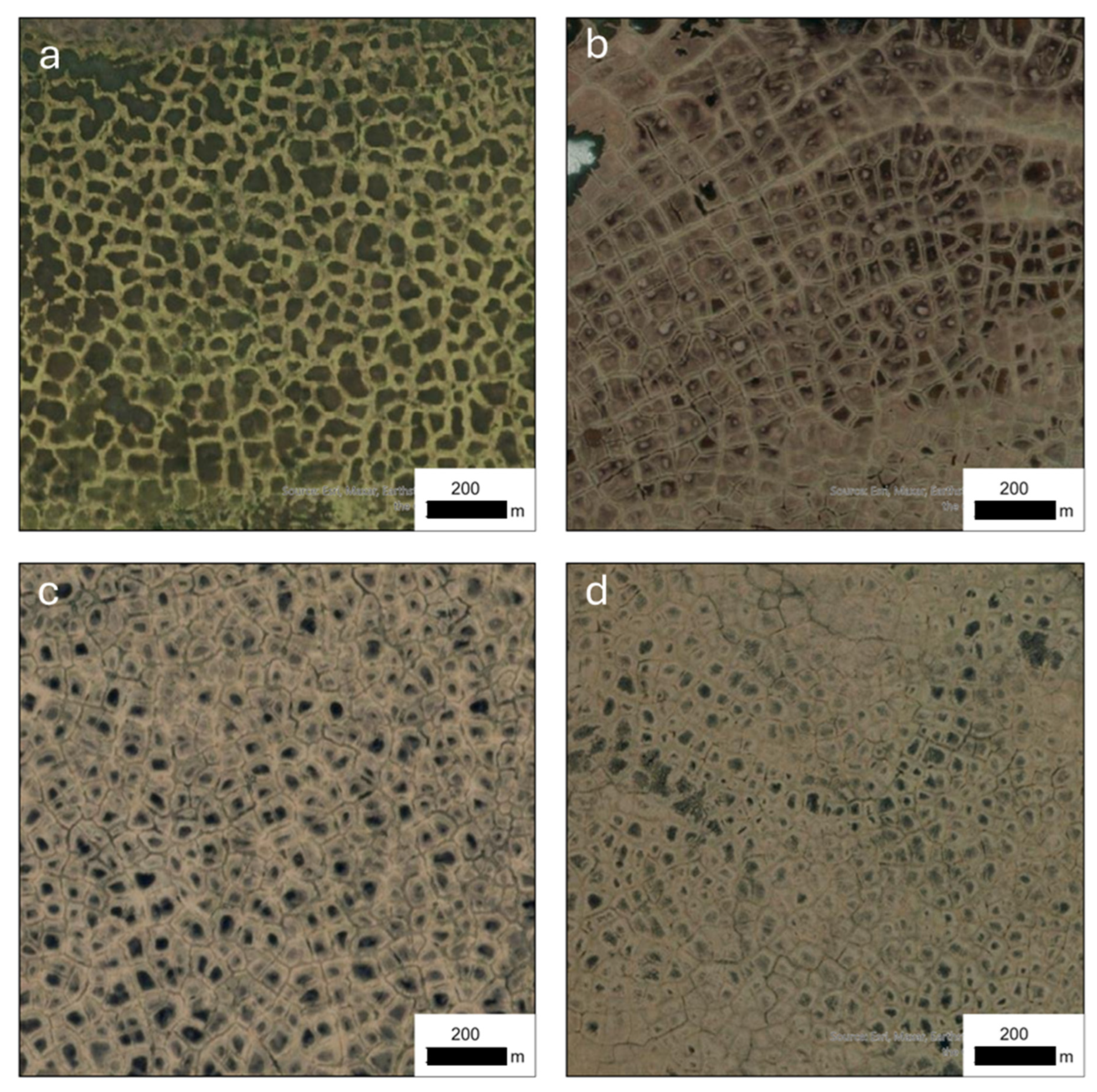
Figure 2.
Oblique field photos from (a) Ellesmere Island, Canada, and (b) the Arctic Coastal Plain of northern Alaska showing the evolution of low-center ice-wedge polygonal networks at a high-Arctic and low-Arctic site.
Figure 2.
Oblique field photos from (a) Ellesmere Island, Canada, and (b) the Arctic Coastal Plain of northern Alaska showing the evolution of low-center ice-wedge polygonal networks at a high-Arctic and low-Arctic site.
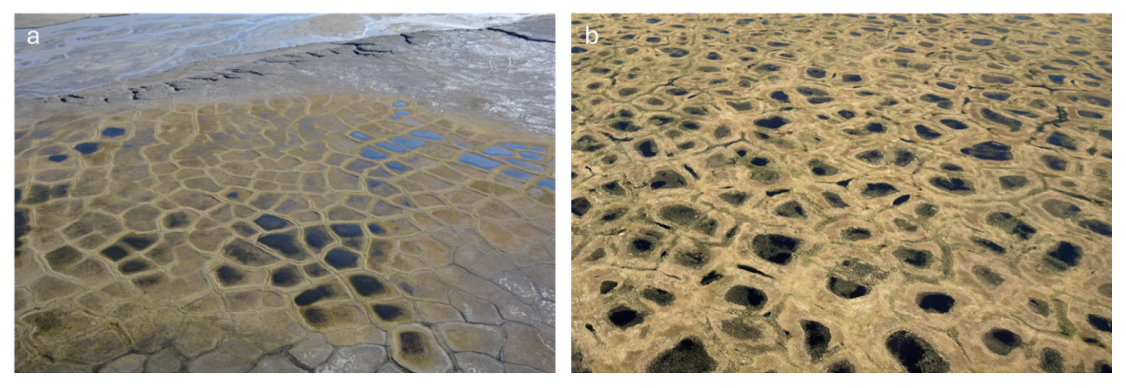
Figure 3.
Hypothesized explanations for formation of low-centered polygons with elevated rims (numbers represent corresponding sections in the text of the paper).
Figure 3.
Hypothesized explanations for formation of low-centered polygons with elevated rims (numbers represent corresponding sections in the text of the paper).
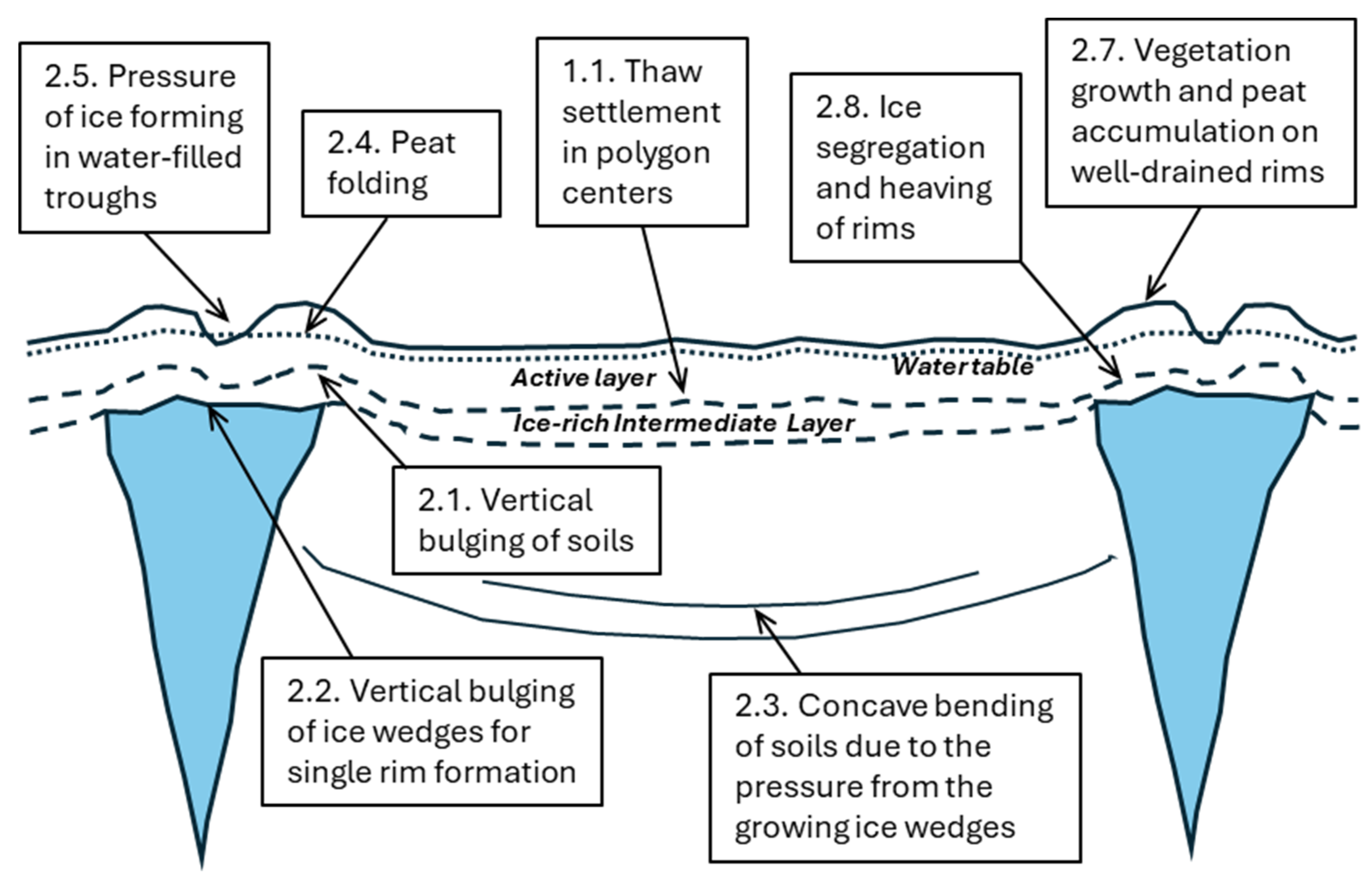
Figure 4.
Exposures of ice wedges illustrate differing patterns in surface and subsurface deformation of soils in response to ice-wedge development, various study sites of the Arctic Coastal Plain (northern Alaska) and Bylot Island (Canadian Arctic). The old surfaces on coastal plain and glacio-marine deposits generally lack rim development, whereas inactive and abandoned floodplains typically have prominent rims.
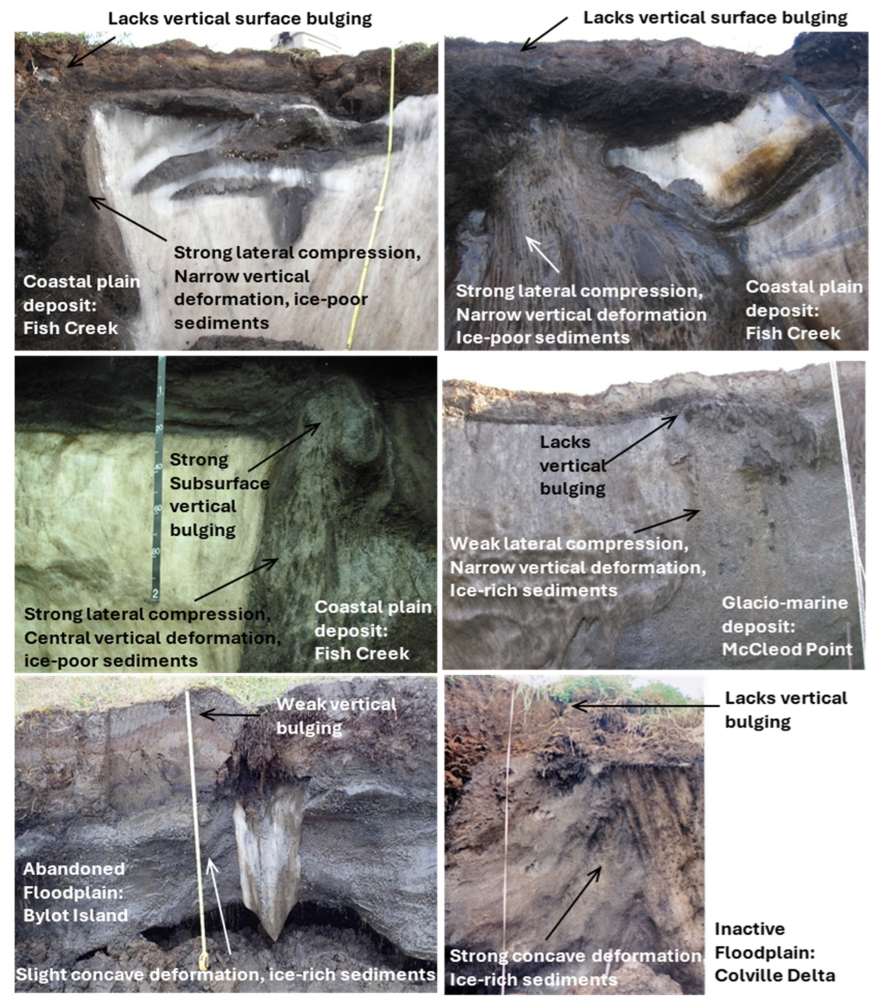
Figure 5.
Field-based evidence showing the formation of ice-wedge polygon rims through segregated ice formation above the ice wedge, courtesy of Dr. Merten Minke.
Figure 5.
Field-based evidence showing the formation of ice-wedge polygon rims through segregated ice formation above the ice wedge, courtesy of Dr. Merten Minke.
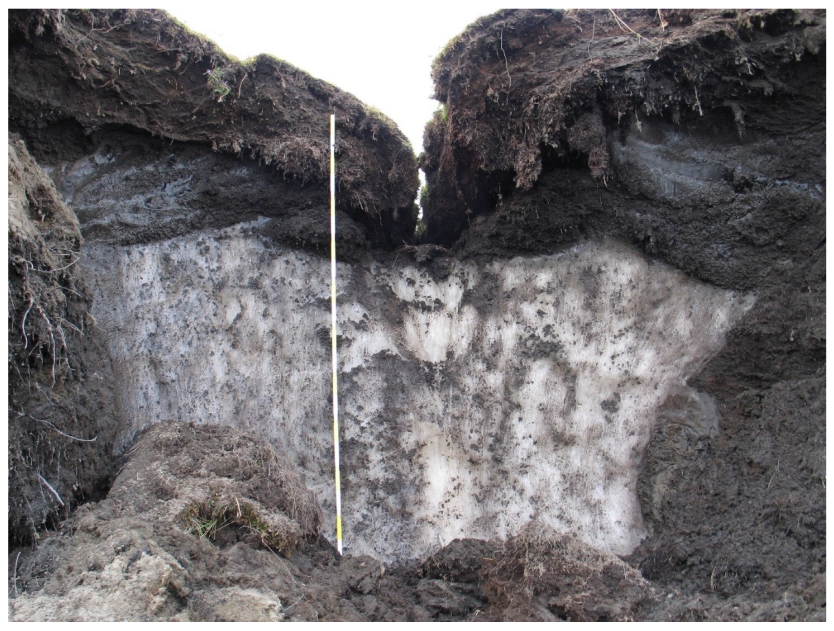
Figure 6.
Profiles across ice wedges in the areas with low-centered polygons, based on drilling data (except B, which is based on excavation data). A – drained-lake basin in the Yana-Omoloy region of northern Yakutia (modified from Ospennikov and Trush, 1974); B – drained-lake basin in the Alazeya River basin, northern Yakutia (modified from Kaplina, 1976); C – alluvial plain in the Prudhoe Bay area, northern Alaska (modified from Kanevskiy et al., 2017); D – drained-lake basin near Point Lay, northern Alaska (modified from Jones et al., 2025); E – drained-lake basin in the Prudhoe Bay area, northern Alaska (modified from Walker et al., 2022b). Note the occurrence of the ice-rich intermediate layer of the upper permafrost above the ice wedges and beneath the elevated rims.
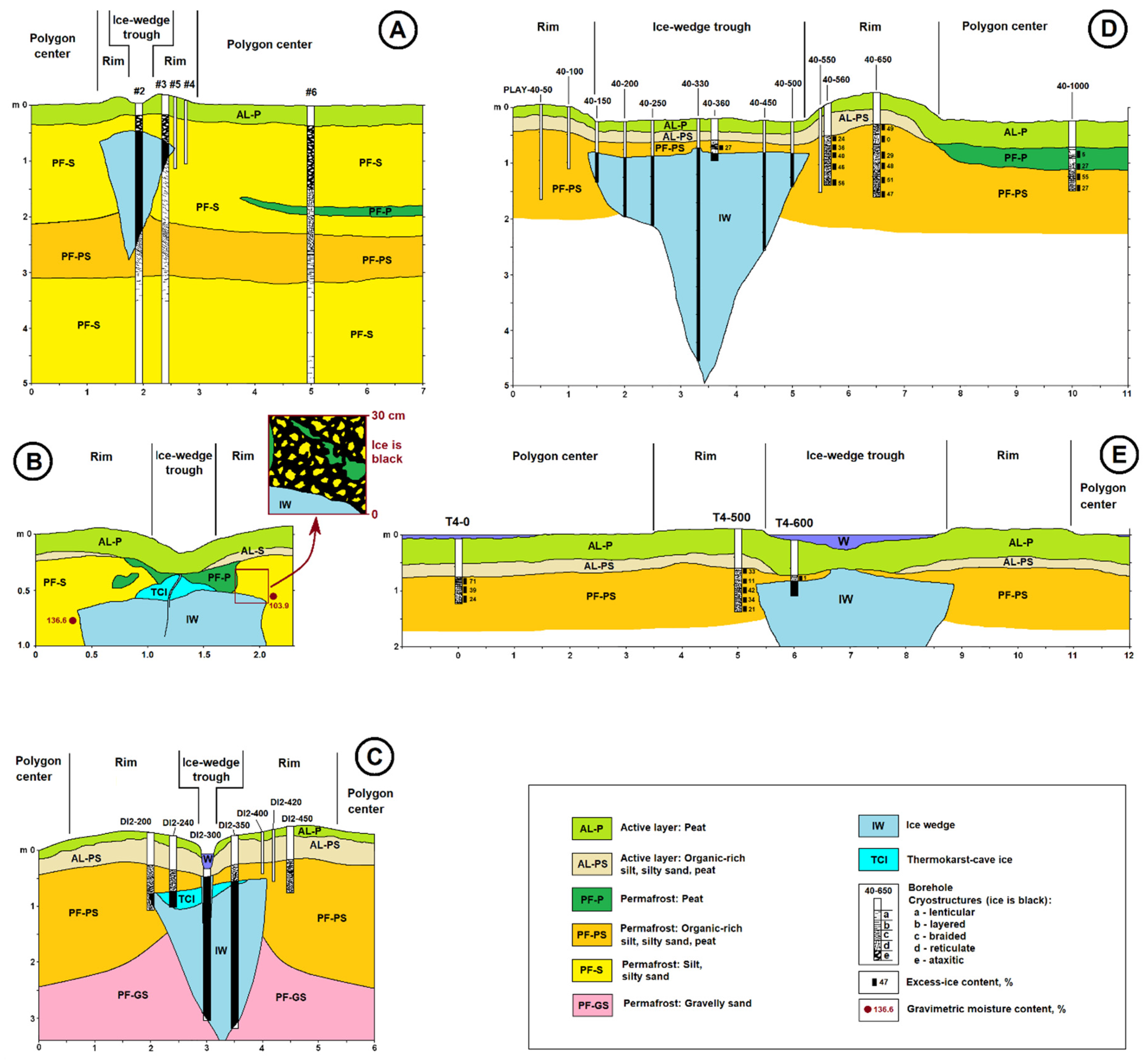
Figure 7.
Examples of the ice-rich intermediate layer above ice wedges in various study areas of northern Alaska.
Figure 7.
Examples of the ice-rich intermediate layer above ice wedges in various study areas of northern Alaska.
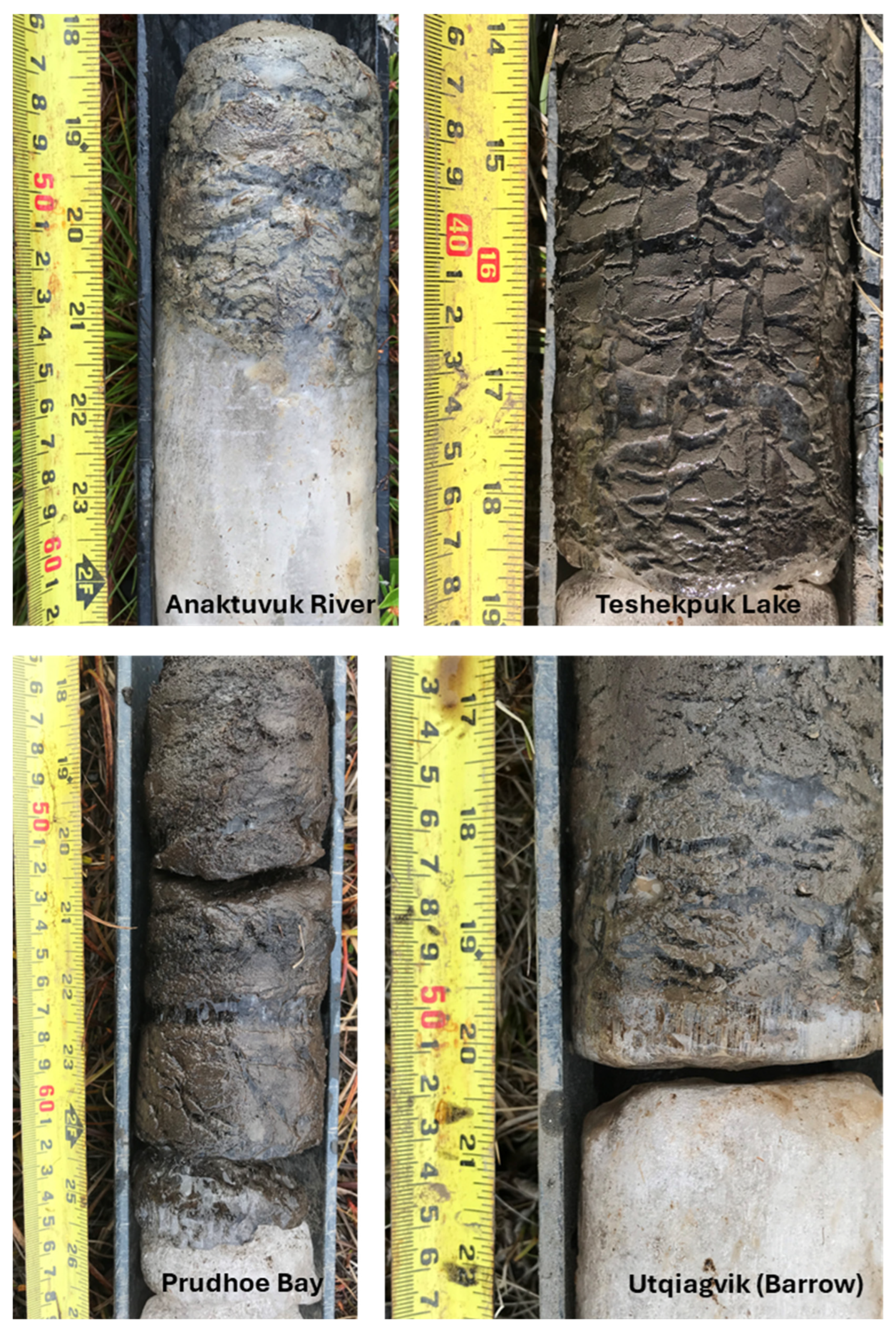
Figure 8.
Conceptual model of evolution of ice-wedge polygons in the continuous permafrost zone. In this model, we consider development of epigenetic ice wedges that start forming in mineral soils at recently exposed flat surfaces.
Figure 8.
Conceptual model of evolution of ice-wedge polygons in the continuous permafrost zone. In this model, we consider development of epigenetic ice wedges that start forming in mineral soils at recently exposed flat surfaces.
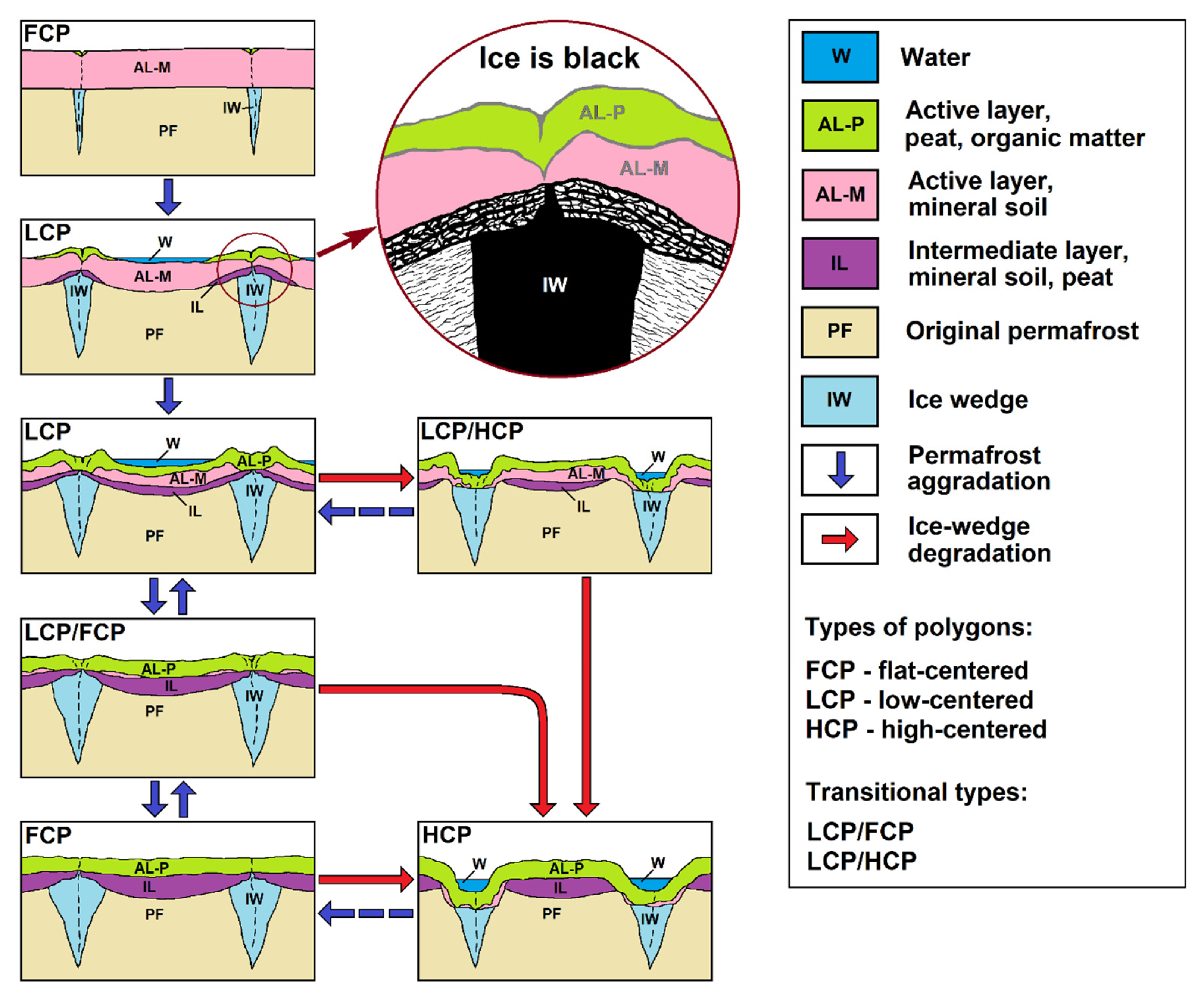
Figure 9.
Orthogonal systems of low-centered polygons. Top: the floodplain of the low Khatanga River, Siberia. Bottom: Drained-lake basin, northern Alaska.
Figure 9.
Orthogonal systems of low-centered polygons. Top: the floodplain of the low Khatanga River, Siberia. Bottom: Drained-lake basin, northern Alaska.
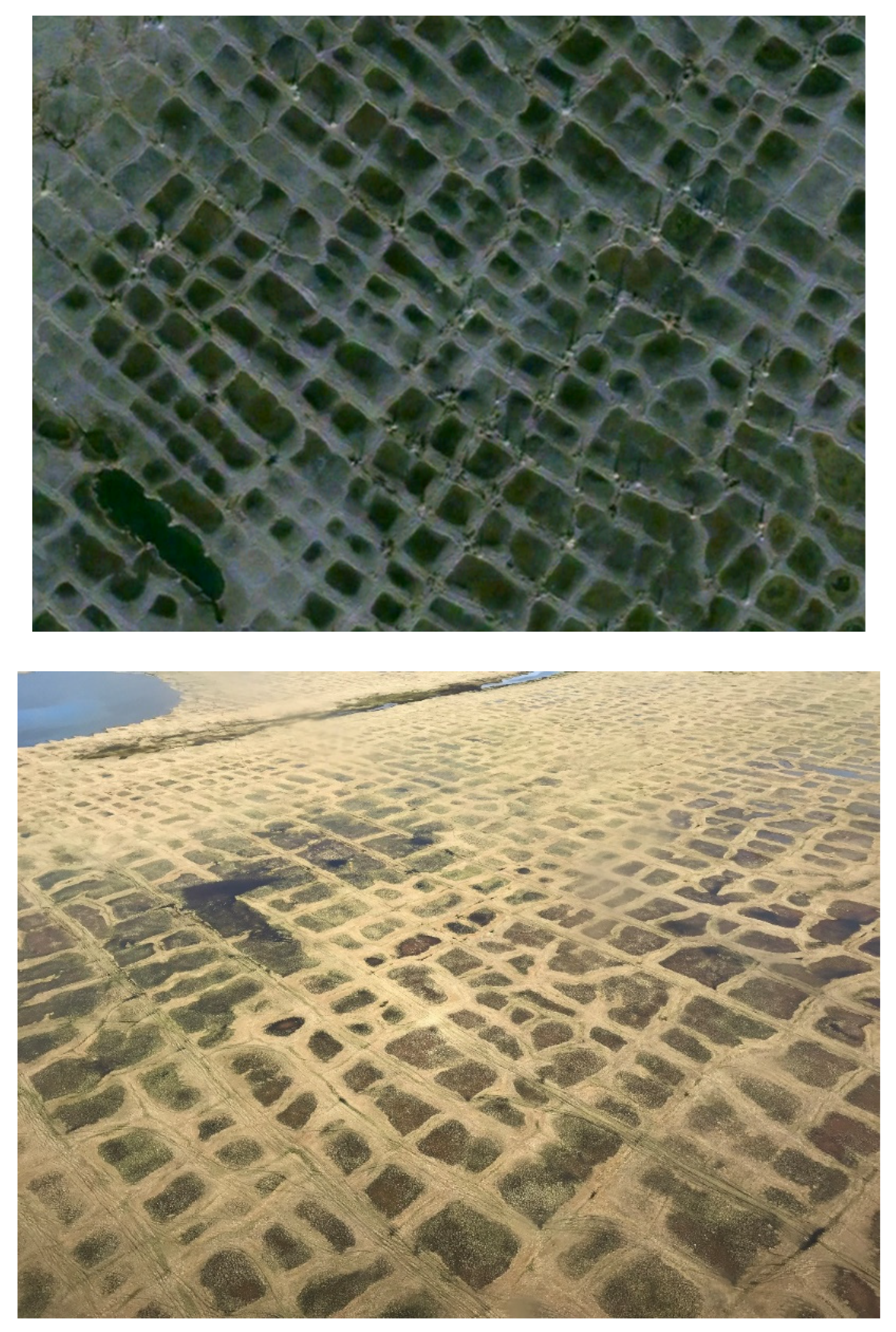
Figure 10.
The first known aerial photographs of low-centered ice-wedge polygon networks, referred to as “Taimyr Polygons,” were taken in Siberia from the Graf Zeppelin dirigible in 1931. (a) The Graf Zeppelin practicing a water landing on the Bodensee (Lake Constance) in preparation for the 1931 polar flight (photo: Edward H. Smith, former WHOI director). (b) One of the set of photographs from the 1931 polar flight captured by the aerial photography cameras in the Graf Zeppelin (Weickmann, 1932).
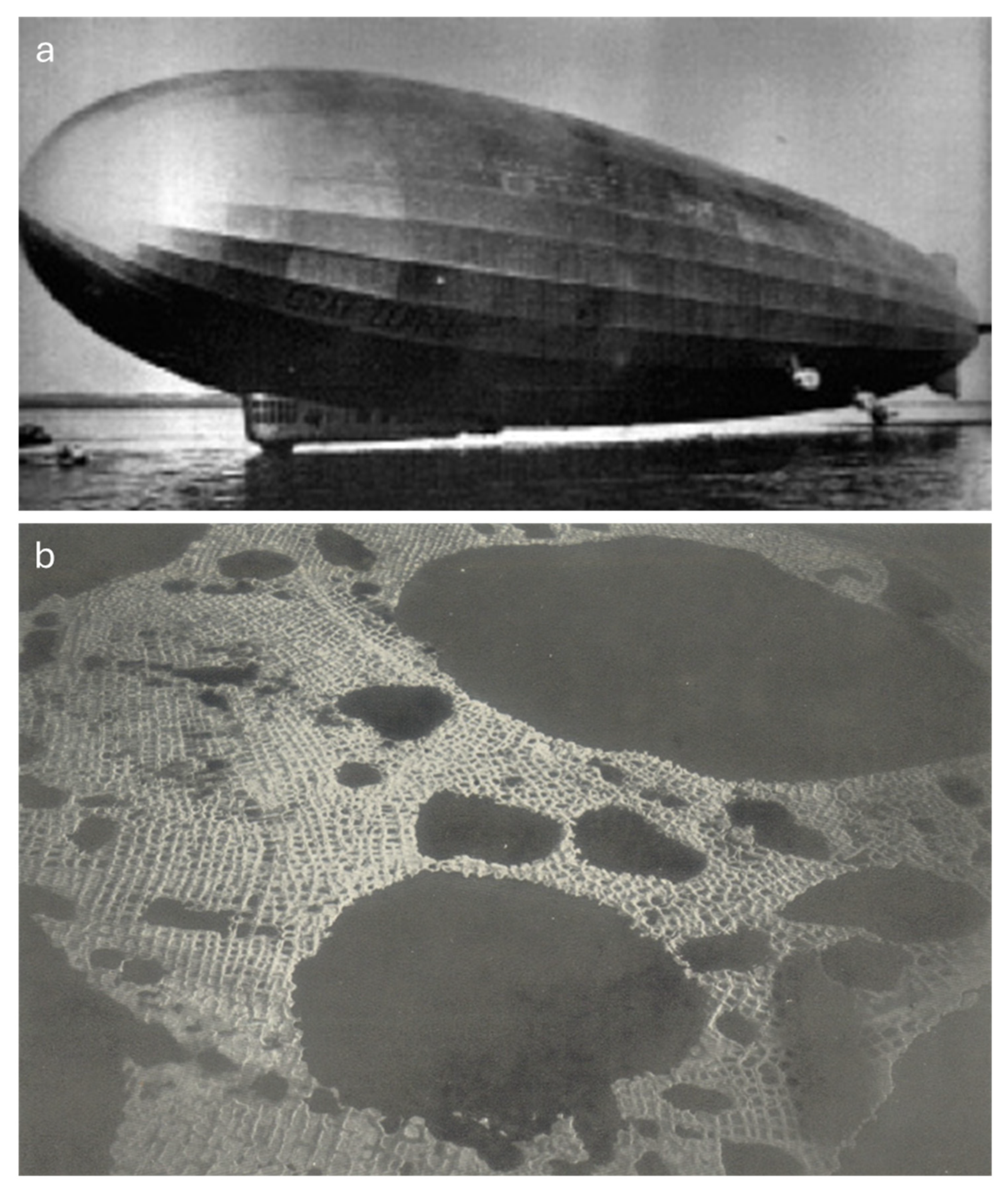
Figure 11.
Top: The orthogonal system of low-centered polygons after Gusev (1938). Старица – Oxbow lake; р. Кoрулах-бигай – the Korulakh-Bigay River. Bottom: Orthogonal net of cracks by a lake and on the terrace of meandering river, examples from Alaska (Jahn, 1975).
Figure 11.
Top: The orthogonal system of low-centered polygons after Gusev (1938). Старица – Oxbow lake; р. Кoрулах-бигай – the Korulakh-Bigay River. Bottom: Orthogonal net of cracks by a lake and on the terrace of meandering river, examples from Alaska (Jahn, 1975).
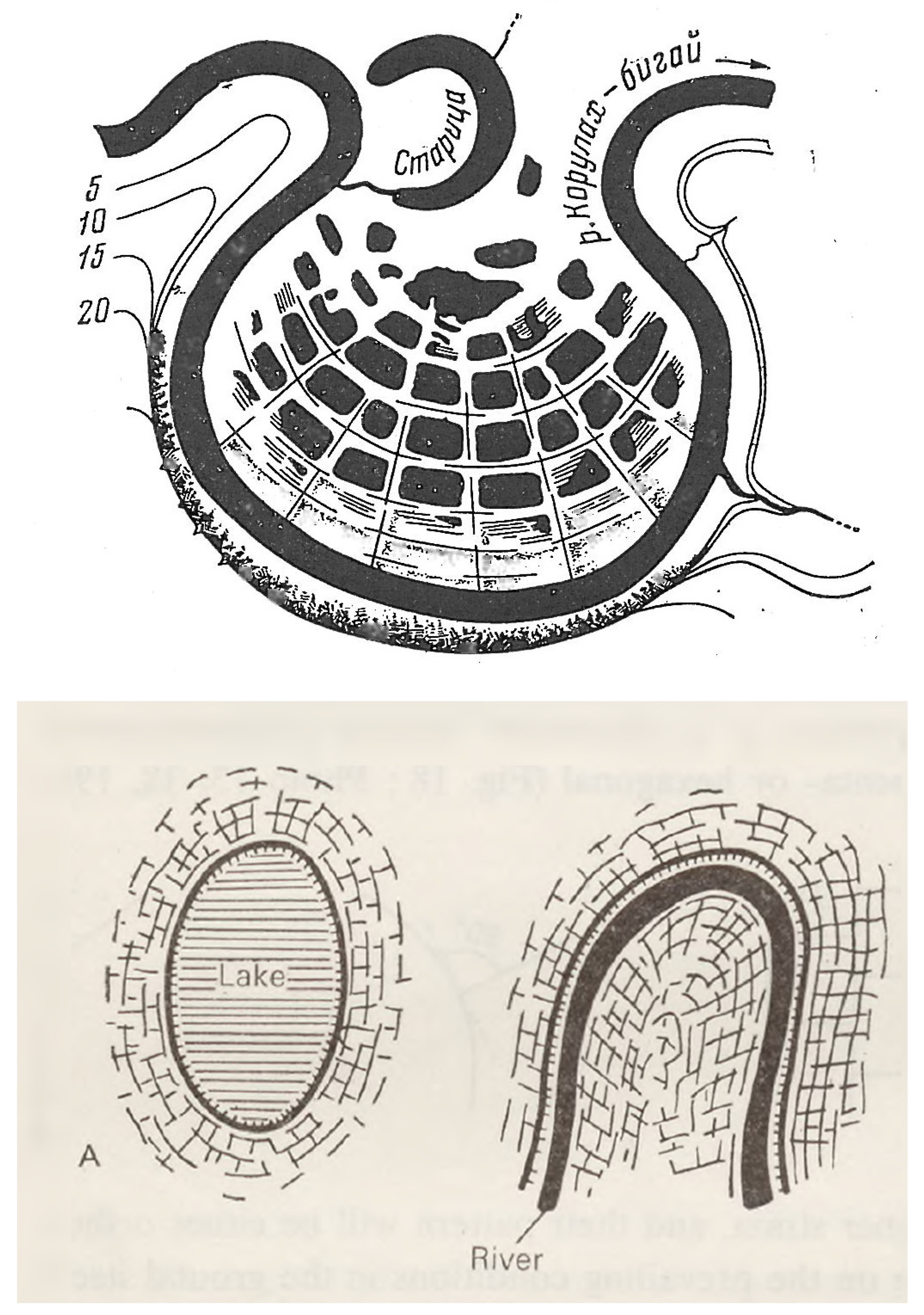
Figure 12.
a) Aerial photograph of ice-wedge polygons in northern Alaska taken in 1948 (Lachenbruch, 1962); b) same site in 2014.
Figure 12.
a) Aerial photograph of ice-wedge polygons in northern Alaska taken in 1948 (Lachenbruch, 1962); b) same site in 2014.
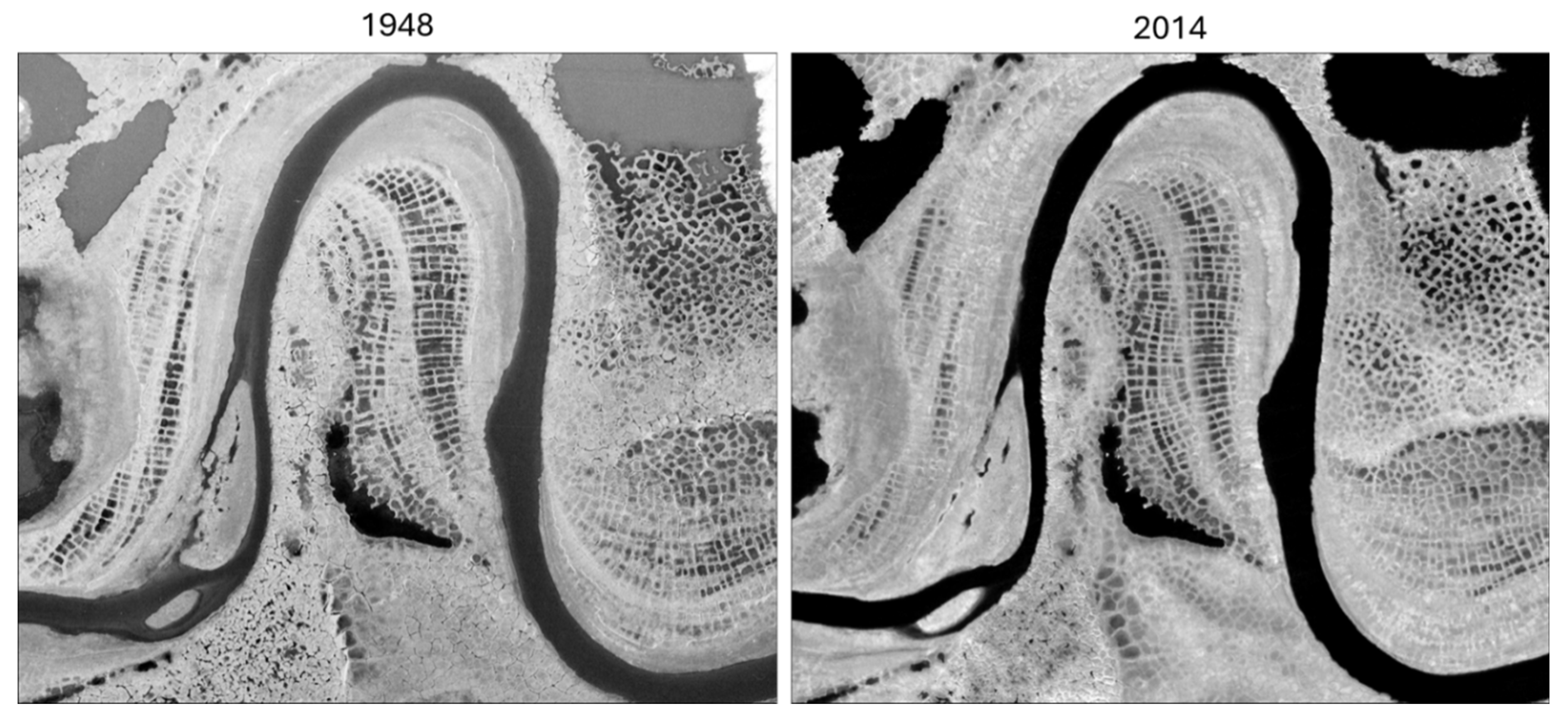
Figure 13.
Change detection for an area of Taimyr Polygons from the Graf Zeppelin polar flight mission in 1931 versus a recent high-resolution satellite image captured in 2019. The top shows a direct comparison between the two georeferenced images and the bottom shows a digitized representation of Taimyr Polygon evolution over the ~90-year time span. The lateral propagation of ice wedges in recent deposits as the river migrated from left to right exposing a fresh surface where permafrost aggraded. The red dashed line shows the old riverbank position.
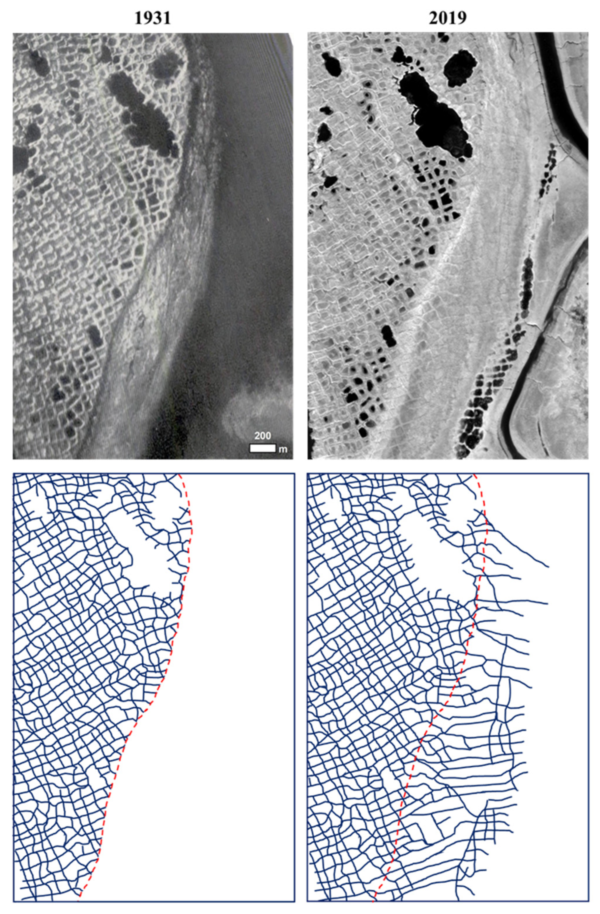
Disclaimer/Publisher’s Note: The statements, opinions and data contained in all publications are solely those of the individual author(s) and contributor(s) and not of MDPI and/or the editor(s). MDPI and/or the editor(s) disclaim responsibility for any injury to people or property resulting from any ideas, methods, instructions or products referred to in the content. |
© 2025 by the authors. Licensee MDPI, Basel, Switzerland. This article is an open access article distributed under the terms and conditions of the Creative Commons Attribution (CC BY) license (http://creativecommons.org/licenses/by/4.0/).
Copyright: This open access article is published under a Creative Commons CC BY 4.0 license, which permit the free download, distribution, and reuse, provided that the author and preprint are cited in any reuse.


