Submitted:
13 March 2025
Posted:
14 March 2025
You are already at the latest version
Abstract
The Kashmir Valley, characterized by its rich loess-palaeosol sequences (LPS), provides a unique geo-archive for reconstructing Late Quaternary climate and paleoenvironmental dynamics. This study presents an extensive multi-proxy study, integrating high-resolution lithostratigraphy, geochemical analyses, stable isotope analysis of soil organic matter (δ13C-VPDB), and radiocarbon (14C) chronology of a sediment sequence approximately 200 cm thick, to unravel the complex interplay of climatic, pedogenic and environmental processes shaping the region spanning the Pleistocene-Holocene transition. The results establish a precise chronology of the sediment sequence between 13.4 ka and 7.2 ka, covering the transition from the Pleistocene to the Holocene Epoch. The results reveal distinct climatic and environmental conditions during this epoch. The study reveals substantial loess deposition during the cold and dry glacial climate towards the end of the Pleistocene, followed by a shift to a warmer and wetter interglacial climate at the onset of the Holocene Epoch. This climatic shift led to the development of soil units with pronounced fluvial characteristics around 10 ka, eventually transitioning to fluvial deposition. Geochemical indices such as Ca/Ti, Al/Ti, Si/Ti, and K/Ti indicate low weathering intensity prior to 11 ka, followed by a noticeable increase around 11 ka, possibly driven by enhanced precipitation. δ13C values, ranging from –26.2‰ to –22.5‰, suggest C3-dominated vegetation during the Late Pleistocene, indicating wetter climatic conditions. This study provides valuable insights into the intricate interactions between climate, soil development, and vegetation dynamics during the critical Late Pleistocene-Holocene transition in the Kashmir Valley.
Keywords:
Pleistocene
; Holocene
; 14C AMS dating
; Kashmir Valley
; Palaeoclimate
; Stable isotope
1. Introduction
Palaeosols serve as one of the important records of the past landscape dynamics and have been extensively studied throughout the globe [1,2,3,4,5,6]. These sedimentary archives provide a unique window into the past, offering valuable insights into climatic, ecological, and geomorphic changes that have shaped our planet over the millennia [7,8,9]. Among the crucial periods in Earth’s relatively recent history, the Pleistocene–Holocene transition stands out as a critical Epoch marked by significant climatic and environmental shifts. The Pleistocene Epoch, characterized by extensive glaciations and ice ages, transitioned into the Holocene Epoch around 11.7 ka ago [10,11]. This transition witnessed a remarkable transformation in climate, vegetation, and faunal assemblages, setting the stage for the development of modern ecosystems [12,13,14]. Palaeosols, with their ability to preserve evidence of past soil–forming processes, organic materials, and environmental conditions, offer a unique opportunity to reconstruct the intricate description of this transition. Through meticulous examination of palaeosols, researchers are able to discern changes in vegetation patterns, soil properties, and the influence of climatic factors during the Pleistocene–Holocene transition [15]. Understanding the dynamics of this critical period holds significance not only for unravelling the Earth’s geological history but also for gaining insights into the mechanisms that have influenced biodiversity, human evolution, and the development of contemporary landscapes [13,14,16].
Research on loess-palaeosols in the Kashmir Valley offers an excellent perspective for comprehending the paleoclimatic and environmental changes that have shaped this region over the Quaternary Period [2,5,9,17,18,19,20]. The intermontane Kashmir Valley has witnessed development and deposition of loess–palaeosols comprising predominantly silt-sized grains, forming distinctive plateau like topography [2,5]. The distinctive loess-palaeosol sequences that characterize this region have been developed by the dynamic interplay of Quaternary glacial-interglacial cycles [7,19].
The western disturbances (WD) have a substantial influence on the climate dynamics in the Kashmir region with a minor influence of the Indian summer monsoon (ISM). The ISM, which is characterized by seasonal wind reversals and moist winds from the Bay of Bengal and the Arabian Sea, greatly increases yearly precipitation, especially from June to September [21]. In contrast, the westerlies, bring winter precipitation from extratropical cyclones that move eastward. In certain portions of the northern India, especially the Kashmir region, the WDs account for approximately one-third of the yearly rainfall during the months of December through February [22,23]. Interestingly, the climate patterns archived in the loess-palaeosols of the Kashmir valley have potential to reveal variations in precipitation intensity, just like continental proxies in areas currently heavily impacted by the ISM. Similar data from the Central Himalayas and the Tibetan Plateau show that the climate was warm-humid and cold-dry termed as Marine Isotope Stage (MIS), which sheds light on previous climatic cycles [24]. Recent studies [2,5] have attempted to examine climate variations by analysing loess-palaeosol sections in the north-western Kashmir Valley using multi-proxy approach, incorporating geochemistry, mineral magnetic, stable isotope and clay mineralogy. These studies suggest that a cold, dry environment prevailed after the Last Ice Age, there was facilitating loess deposition. This was followed by multiple warm, humid intervals that supported soil formation, with a particularly notable warm-humid phase occurring approximately 35 ka [2]. Dar et al. [25] studies three loess–palaeosol sections at Shankerpora (SP), Khan Sahib (KS) and Pattan (PT) in the Kashmir Valley through detailed lithostratigraphic fieldwork and micromorphological analysis of thin sections. Additionally, several other studies have examined the litho-stratigraphy, chronology, magnetic susceptibility, and morphological properties of loess–palaeosols sequence in Kashmir Valley [19,20,26,27,28].
The previous investigation of the Makaibagh loess-palaeosol section [2] is centred on the palaeosol development in a 6-meter vertical section (2 to 8 m depth). The section, originating solely from aeolian processes, underwent evolution between 65.8 ±7.2 ka and 14.7 ±5.4 ka. Notably, the upper 2 meters of the section, younger than 14.7 ±5.4 ka, show mixed fluvial sedimentation, which has remained unexplored in the previous studies. The novelty of this research therefore lies in its comprehensive exploration of the previously unexplored upper 2-meter section (0–2 m), which represents a critical transition from predominantly aeolian sedimentation during the Pleistocene to mixed fluvial deposition in the Holocene. Unlike earlier studies focused on palaeosol development within aeolian-dominated sediments, this research integrates stratigraphic profiles, new geochemical, isotope and geochronological data to investigate the climatic and sedimentological shifts occurring during the Pleistocene-Holocene transition. By reconstructing palaeoenvironmental conditions during this period, the study not only establishes a detailed timeline of sedimentary processes but also provides unique insights into the interplay of climatic variability and landscape evolution in the Kashmir Valley. This approach fills a significant gap in understanding the region’s response to late Quaternary climate dynamics.
2. Study Area
The Kashmir Valley has a unique and varied lithological composition that spans multiple geological ages, from metamorphosed Precambrian rocks to more recent sediments [29]. It is located between the Pir Panjal Range in the southwest and the Great Himalayan Range in the northeast. The lithology that predominates the areas between the two mountain ranges is made up of Karewa deposits (Figure 1), which are dominant in the central part of Kashmir, and Permian Panjal traps, which are primarily composed of basaltic rock [18,25,26,30]. Terrigenous Plio-Pleistocene Karewa sediments span an area of 2500 km2 and have a significant thickness of about 2000 meters [2]. These sediments are divided into the lower and upper Karewas and are composed of unconsolidated gravel, sand and mud successions that form vast terraces that resemble plateaus. These deposits cover the Triassic limestone and the Late Permian Panjal traps. They are distinguished by horizontal bedding and a small inclination toward the Pir–Panjal range [31]. Moreover, a number of Quaternary loess-palaeosol sequences (LPS) that span the valley vary in thickness on an average from roughly 22 m in the southwest to roughly 5 m in the northeast [2]. As the youngest member of the upper Karewa group, the Dilpur formation covers an area of approximately 500 km2 covering the Karewa sediments. Its maximum thickness varies from 22 m in the southeast to 10 m in the northeast of the Kashmir Valley [32]. On the Pir-Panjal side, the nearly horizontal loess layers rest directly over the gravel bed of the Shopian member [33]. The Himalayan and Pir Panjal ranges significantly influence the climate of the Kashmir Valley.
The Kashmir Valley’s subtropical climate is mostly determined by its physical location and is heavily impacted by the westerlies. Annual temperatures range from –10 °C in winter to 35 °C in summer [34]. Westerly winds from the North Atlantic and Mediterranean Seas contribute to the precipitation that falls throughout the winter months in the form of rain and snow [35]. Due to the western disturbances, more than 60% of the precipitation falls during winter and spring, with the ISM partly responsible for the remaining 40% of the precipitation during the warm summer months [30]. The Kashmir valley floor currently experiences around 710 mm of mean annual precipitation and 13.5 °C of mean annual temperature [30]. The autumnal months of September and October are usually dry, and the summers are somewhat hot with sporadic showers of mostly convective rains. Monsoon winds also provide summertime rains in the Pir-Panjal range and the plains that surround it. However, the Southwest Monsoon (SWM) has little effect on the total amount of precipitation in the Kashmir Valley [34,35]. Although the vegetation in the Kashmir Valley shows distinct altitudinal zonation, C3 type vegetation is generally dominant in the region [36].
The present study was conducted on the Makaibagh section, near Nagbal village in the central Kashmir, a key part of the extensive loess-palaeosol sequence (LPS). This 800 cm thick deposit features five well-developed palaeosol horizons, consisting of wind-blown (aeolian) sediments interbedded with palaeosols (ancient soil layers), formed due to alternating dry and wet climate phases over thousands of years [9]. These distinct layers provide valuable insights into past environmental conditions, with loess layers indicating arid periods of high wind activity, while palaeosols represent wetter intervals with increased vegetation [15].
The Makaibagh section serves as an important archive for studying Late Quaternary climate shifts, offering a record of wind patterns, precipitation changes, and landscape evolution in the Western Himalaya [9]. Optically stimulated luminescence (OSL) dating has placed its formation between ~65.8 ±7.2 ka at base level and ~14.7 ±5.4 ka at 205 cm depth from top [2]. The lower 600 cm primarily consists of aeolian loess interspersed with palaeosol layers, reflecting climate variations, while the upper 200 cm contains redeposited mixed loess and fluvial sands, indicating a transition from aeolian to fluvial deposition, likely caused by increased precipitation or glacial melting post-14.7 ±5.4 ka [2]. The Makaibagh LPS plays a crucial role in reconstructing Late Quaternary palaeoenvironmental changes and correlates with other regional loess deposits in central Kashmir, enhancing our understanding of past climate dynamics in the Western Himalaya.
3. Materials and Methods
3.1. Mapping and Sampling of Palaeosol Section
The ~210 cm thick section underwent a detailed field investigation to identify and distinguish various soil and palaeosol horizons (Figure 2). Despite the absence of vegetation on the exposed vertical cliff, the entire section was carefully scraped to reveal fresh soil horizons for mapping and sampling. The section was meticulously mapped during fieldwork, and key attributes such as color, texture, sedimentary structure and other notable features were recorded. Sediment samples were systematically collected at 10 cm intervals for geochemical analyses, while targeted samples were collected within 1 cm sections at specific depths for radiocarbon dating. A total of 21 samples, each weighing between 400 to 500 grams, were collected in airtight zip-lock polybags from the entire section (Figure 2), oven-dried in laboratory and subsequently analysed for geochemical analyses. Soil and sediment color and texture variations were determined using the Munsell color chart. Grain-size distribution was assessed using the sieve and pipette method [37], enabling the estimation of sand, silt, and clay percentages.
3.2. Chronology: Accelerator Mass Spectrometry (AMS) Dating (14C)
Radiocarbon (14C) dating of bulk organic-rich sediments was carried out on four samples at the Inter University Accelerator Centre (IUAC), New Delhi, using 500kV Accelerator Mass Spectrometry (AMS) system [38]. The methodology employed for chronology followed the procedures outlined by Shah et al. [1] Initially, the samples underwent an acid-base-acid treatment involving the sequential application of 1M HCl and 0.5N NaOH solutions. At each step, the samples were thoroughly washed and neutralized with deionized water before being freeze-dried. A measured quantity of the dried samples was then carefully packed into tin capsules and combusted at 9000C in the presence of high purity oxygen environment inside the combustion tube of the elemental analyser. The resulting carbon dioxide was carried by helium gas to a graphitizing machine, where it was converted into graphite using iron as a catalyst and the hydrogen as a reducing agent [1].
The AMS- acquired 14C dates were calibrated using OxCal v 4.4.4 and the IntCal 20 atmospheric calibration dataset [39]. The age-depth model was also generated using the same software. The calibrated ages were expressed in kilo years before the present (ka BP) with a 2σ uncertainty (95.4% probability). For age modelling, a P-sequence deposition model was employed to account for the intricacies of the actual processes involved in sediment deposition [40].
3.3. Major Oxide Analysis
Geochemical analyses of major oxide concentrations were conducted using the X-ray fluorescence spectrometry technique (Axios, Panalytical). For this procedure, finely powdered samples (10 g) were thoroughly mixed with 1 gm of wax binder in an agate mortar. The resulting mixture was then placed in standard aluminium cups (30 mm) and compressed at 150 kN pressure using a hydraulic press to form XRF sample pellets. Data reproducibility was verified and ensured through repeated analyses of USGS (MAG–1) and laboratory (SDO–1) standards, with analytical precision for major oxides maintained below 5% at the 2σ level.
The obtained major oxide composition was used to compute the Chemical Index of Alteration (CIA) following equation 1 proposed by Nesbitt and Young [41], and the Chemical Index of Weathering (CIW) using equation 2 according to Harnois [42]. This analytical approach provides understanding of chemical weathering intensity and mineral alteration within the sediments, yielding valuable insights into the impact of source rock composition, the duration of weathering, prevailing climatic conditions, and the rates of tectonic uplift in the source region.
In Eq. (2), CaO* represents the content of CaO constituting silicate fractions. The measured CaO values in the studied soil and sediments range between 2% to 10%, suggesting that a notable portion may be attributed to pedogenic carbonates within the sediments [43].
3.4. Total Organic Carbon (TOC), Nitrogen (N), CaCO3 and Stable Isotope (δ13C) Analysis
Total Organic Carbon (TOC), nitrogen (N) and stable isotopic compositions (δ13C) of bulk organic matter were analyzed using a continuous–flow isotope ratio mass spectrometer (Delta V–Thermo Fisher) coupled with an elemental analyzer (Flash 2000). Sample preparation involved treating dry and finely powdered samples with 1 M HCl solution at 70–80°C for 2 hours to remove carbonates. After treatment, samples were washed with double deionized water, followed by centrifugation to neutralize samples.
The CaCO3 content in the sediments was determined employing a titration method, following the procedure outlined by Loring and Rantala [44]. In this process, 5 grams of dried sample was placed in a 250 ml beaker, and 100 ml of 1M HCl solution was added. The mixture was stirred at intervals of 3 to 5 minutes for 45 minutes, followed by a resting period of 15 minutes. Then, 20 ml of the supernatant from the sample solution was transferred to a 250 ml conical flask, and 7–8 drops of Bromothymol blue indicator were added. The supernatant was then titrated against sodium hydroxide (NaOH) until the appearance of a blue color, indicating the endpoint. Each sample underwent two replicate titrations, and as a control, two blank solutions without sediment samples were titrated. The CaCO3 was calculated using Eq. 3.
For δ13C analyses, approximately 5–10 mg of carbonate–free samples were combusted in the Flash 2000 elemental analyzer at 1020 °C under an oxygenated environment. The resulting CO2 gas was then analyzed online using a Delta V Plus IRMS. Data were normalized to the Vienna Pee Dee Belemnite (VPDB) reference scale using International Atomic Energy Agency standards (LSVEC, NBS–19, and CH–3), following the method outlined by Paul et al. [45]. Analytical precision was assessed and monitored by analyzing Oxalic Acid (IAEA–C8), yielding a standard deviation of ± 0.12‰, (1δ, n = 5). Repeated standard measurements yielded δ13C precisions of less than 0.2‰, while TOC and N content measurements maintained an analytical precision of ±10%.
4. Results
4.1. Sedimentological Features
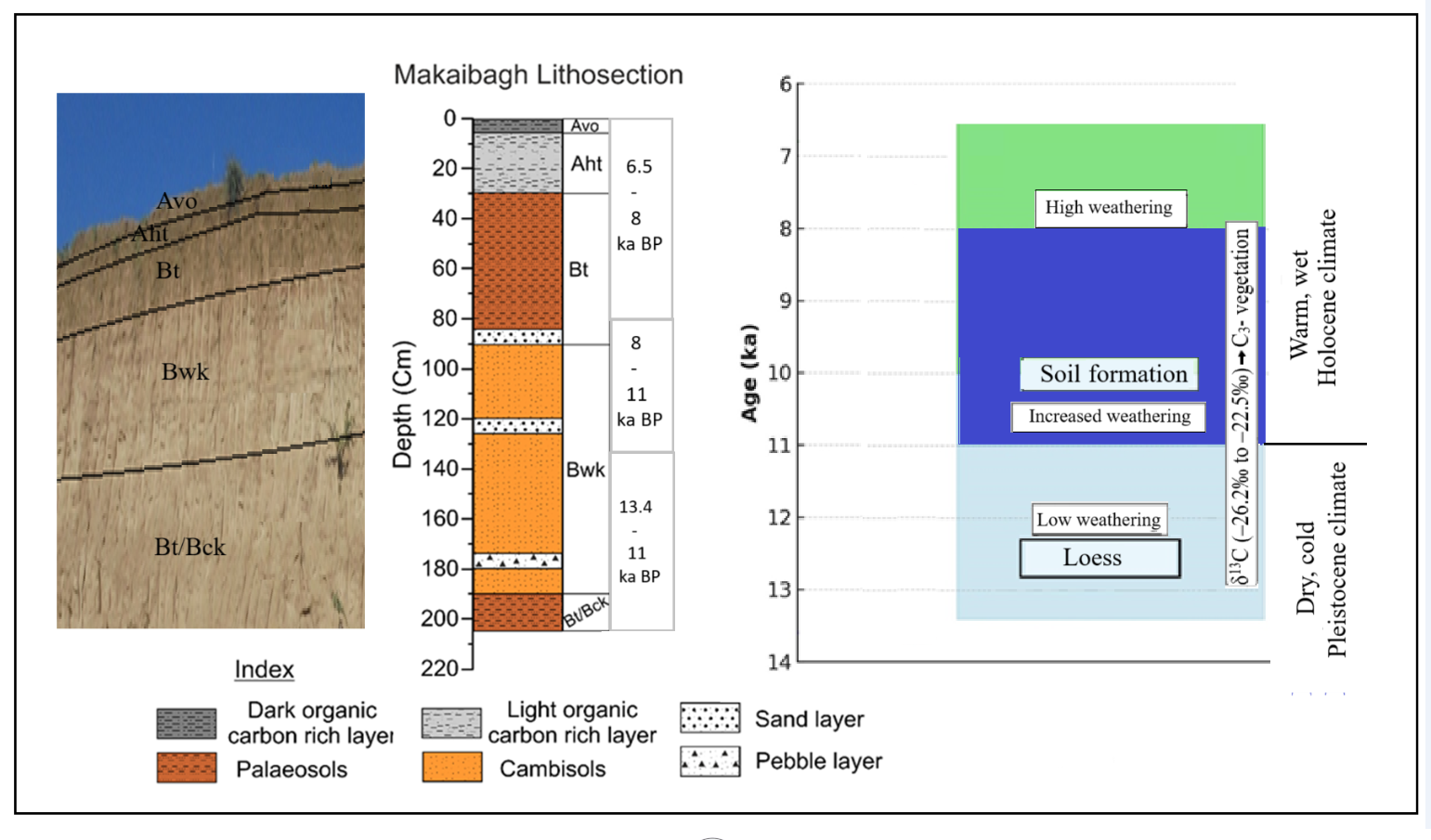
A detailed description of the studied sediment section is given in Table 1. The different soil and palaeosol horizons show marked variations in color, texture, and grain size. On the basis of physical and chemical characteristics, five polycyclic palaeosol units were identified: Avo (5–1 cm), Aht (30–6 cm), Bt (90–31), Bwk (190–91 cm), Bt/Bck (205–191 cm) (Figure 3a). The uppermost 5 cm thick soil horizon (unit–5, Avo) is characterized by dark brown color (10YR 2/2, 4/2) due to high organic carbon content. This horizon manifests high silt and moisture content, with abundant plant root traces and is porous. The 25-cm thick (unit–4, Aht) layer is dark brown in color (10YR 3/2, 3/1), enriched in organic carbon, and features visible root channels filled with fine silt. This layer is also characterized by well-developed peds with gradual transition to the lower horizon. The 60-cm thick horizon (unit–3, Bt) appears dull brown in color (7.5 YR 5/3, 5/4) and contains more sand content than silt and clay fraction (Figure 3b-d). The layer is characterized by a moderately developed palaeosol interbedded with sand layers and has low CaCO3 content. Reddish-brown coloured Fe/Mn nodules are scattered within this horizon. A 5-cm thick (85–90 cm) sand layer at the bottom of the third horizon suggests prominent fluvial activity. A 100-cm thick layer (Unit-2, 90–190 cm) is light grey in color (7.5 YR 8/1), contains weakly altered sediments and has high CaCO3 and pedogenic nodules. A distinct sand horizon (120-125 cm) indicates high fluvial reworking of aeolian sediments. Furthermore, a 5-cm thick pebble/ gravel bed (175-180 cm) at the base suggests high fluvial activity due to high-energy meltwater deposition from nearby mountains, marking the end of loess deposition. A sharp contact with the overlying horizon is also observed. The 15-cm thick (190–205 cm) basal layer (Unit-1, Bt/Bck), is grey is brown to grey in color (7.5 YR 8/2), and is characterized by a weakly developed palaeosol with very high CaCO3 content. The horizon indicates reduced weathering and the final stage of sediment deposition within the section.
4.2. Chronology and Sedimentation Rate
The calibrated AMS 14C dates are presented in Table 2, indicating that the top two meter of the section represent sediment deposition from the Late Pleistocene to Mid–Holocene. All analysed sediment samples maintain stratigraphic order, with no observed age reversals. Aht horizon sample (unit–4) at 25-cm depth yielded an age of 6422 ± 41 14C yr BP (7202 ± 41 cal yr BP). The Bt horizon (unit-3) palaeosol sample at 75-cm depth yielded an age of 6849 ± 41 14C yr BP (7892 ± 42 cal yr BP). The cambisol (unit–2) sample at 125 cm depth provided an age of 9639 ± 53 14C yr BP (10830 ± 68 cal yr BP). The Bt/Bck horizon (unit–2) sample from 205 cm depth yielded an age of 11521 ± 48 14C yr BP (13396 ± 51cal yr BP).
The age–depth model applied to the entire lithosection (Figure 3e) reveals fluctuating sedimentation rates during the Pleistocene–Holocene transition, with a notably high sedimentation rate during the Early to Mid–Holocene period. A significant increase in sediment accumulation rates (~72.46 cm/ka) is observed around 75 cm depth (Figure 3e), coinciding with a shift in sediment grain size, indicating changes in sediment production processes in the catchment area. Overall, diverse sedimentation rates are recorded across different units in the section (Figure 3e).
4.4. Bulk Geochemistry
The major oxide concentrations (wt%) in Makaibag palaeosol section are detailed in Table ST2. The section displays variability in normalized Al2O3 and SiO2 contents, ranging from 17.09-19.59 wt % (mean: 18.15 ± 0.60) and 53.96-61.23 wt %, (mean: 57.83 ± 1.64) respectively. The abundance of Fe2O3 ranged from 7.01-10.75 wt % (mean: 9.13 ± 0.89), while CaO and MgO exhibited abundance ranging from 12.41-7.11 wt % (mean: 4.55 ± 1.31) and 2.95 to 6.46 (mean:4.88 ± 0.76) wt %, respectively. K2O and Na2O concentrations ranged from 2.04 to 3.27 wt % (mean: 2.69 ± 0.31) and 1.01 to 1.64 wt % (mean: 1.40 ± 0.16), respectively. P2O5 concentration ranged from 0.11–0.22 wt % (mean: 0.18 ± 0.02)), that of TiO2 from 0.78–1.21 wt % (mean: 1.03 ± 0.11), and MnO concentration was in the range of 0.14–0.21 wt % (mean: 0.17 ± 0.02) in the Makaibag palaeosol section.
The selected geochemical ratios were calculated and are shown in Figure 4. The Chemical Index of Alteration (CIA), which ranged from 69.10 to 74.20 (mean: 70.65 ± 1.40), was used to assess the degree of chemical weathering. The Chemical Index of Weathering (CIW) showed distinct variation across different depths and varied from 69.10 to 74.20 (mean: 70.65 ± 1.40). Overall, these geochemical ratios effectively captured the Pleistocene–Holocene climatic transition, revealing diverse depositional conditions.
4.5. Bulk Organic Geochemistry (TOC, N) and CaCO3
The TOC, nitrogen, and CaCO3 percentages are presented in Table 3 and shown in Figure 5. TOC content displays variability ranging from 0.07% to 0.41% (at 91–110 cm depth), with an average of 0.21%. Particularly, higher TOC concentrations are associated with the top Avo and Aht horizons (1–30 cm depth), ranging from 0.26% to 0.37%. Original parent material (cambisols) exhibits minimal pedogenic alteration and contains a lower TOC content (<0.020%).. Nitrogen content (N %) remains stable ranging from 0.04% to 0.1%, with higher values (0.1% to 0.2%) in the Avo and Aht horizons (0-30 cm depth). The depth-wise N and TOC shows a similar pattern (Figure 5). The CaCO3 % content of the sediment samples varies from 0.50% to 13% with relatively high amounts of CaCO3 (7% to 13%) observed at depths of 191–450 cm, corresponding to the time span from 35 ka to 13 ka [2].
4.6. Stable Carbon Isotope Composition (δ13C)
The δ13C in the bulk sediment organic matter ranges from –26.19‰ to –22.47‰ (mean: –24 ± 1.10‰), with an overall variability of –4.12‰ (Table 3). This range suggests a dominant contribution of organic matter from C3 plants. In the loess horizon (at 145 cm depth,), δ13C values are relatively positive, measuring –23.69‰. The depth-wise δ13C plot (Figure 5) reveals more negative values, specifically at a depth between 201–210 cm (–24.04‰) and 120–130 cm (–26.19‰), and more positive values around 20–10 cm (–22.04‰),), which is associated with palaeosol formation. Despite mild variations of δ13C values with depth, there is no indication of a major shift from C3 to C4 vegetation.
5. Discussion
5.1. Geochemical Characteristics and Palaeoweathering
Palaeosols serve as valuable sedimentary archives for reconstructing palaeoclimatic conditions, including palaeoweathering patterns and pedogenesis development [2,16,46]. Our dataset (Figure 4). highlights significant variations in major oxide concentrations across the studied sediment section. These variations can be attributed to the lithological differences between the Pir Panjal flank, dominated by basic igneous rocks and the Himalayan flank characterized by limestone dominance [18]. The palaeosol sediments, dating back to the Pleistocene and Holocene, primarily originate from the weathering of basaltic–andesite rocks of the Pir Panjal Mountain Range, which are high in Fe and low in Mg [47]. However, the lower Fe content in the Pattan loess–palaeosol section (mean Fe2O3: 7.5 wt%) suggests either a shift in sediment source or the incorporation of material from the Himalayan flank [5]. Similarly, a significant change in Fe2O3, Al2O3 and CaO content between 10 ka and 11 ka in Makaibagh palaeosol section suggests a provenance shift, significantly influencing oxides variability. Additionally, the Ca mobility, reflected in large variations in CaO content during warm periods, aligns with the findings by Shah et al. [2], suggesting dry climatic conditions in the late Pleistocene.
To assess the weathering history, we employed chemical weathering indices such as CIA and CIW. The CIA values ranged from 69.1 to 74.2 (mean: 70.7 ± 1.4), suggesting moderate weathering conditions, while the CIW values varied between 76.1 and 84.7 (mean: 79.7 ± 2.3), indicating moderate to high weathering patterns in the Makaibagh palaeosol section. These observations suggest a relatively stable climate during the Late Pleistocene. However, a higher CIW value after 9.5 ka, coinciding with the observed variations in the K/Ti ratio, suggests a shift towards warmer and wetter conditions. The Al2O3–CaO*+Na2O–K2O (ACNK) ternary diagram (Figure 6), shows that the studied palaeosol samples follow a weathering trend parallel to the A–CN line, indicating the leaching of Ca and Na while K remains retained in clay minerals during silicate weathering [5]. Compared to southeastern sections [48], and the Pattan section in the northwestern part of the valley [5], the Makaibagh palaeosol section exhibits a relatively lower degree of weathering.
The removal of base elements (Ca, Na, K, and Mg) from soil profiles is primarily influenced by water availability, which is often correlated with rainfall. In a humid climate with increased rainfall, base elements are rapidly leached, whereas immobile elements like Al and Ti tend to accumulate [16,49]. Ratios of base elements (Ca, Na, K, and Mg) to Ti within a soil profile provide insights into base loss due to leaching. In the studied Makaibagh palaeosol section, Mg/Ti and Ca/Mg ratios generally exhibit an upward increasing trend with occasional sharp excursions while Na/Ti exhibit a declining trend, indicating the preferential leaching of Na, which is more mobile than Mg and Ca in a weathering profile.
5.2. Pleistocene and Holocene Transition
Phase – I: Late Pleistocene (140 cm -210 cm; 13.4 - 11 ka)
The sedimentary deposits below 210 cm in the 8-meter section under investigation were exclusively of aeolian origin, consistent with previous studies [2]. Notably, the sediments between 190 to 210 cm exhibit a greyish brown or grey hue (7.5 YR 8/2), and were initially deposited as aeolian sediments. Over time, these deposits underwent weak pedogenesis, forming poorly developed palaeosol, with relatively high CaCO3 content (>7%). Following this phase, a cambisol horizon layer developed, characterized by light grey sediments (7.5 YR 8/1) with elevated CaCO3 content and pedogenic nodules. At the base of this unit, a 3-4 cm thick pebbles/gravel layer marks a distinct boundary with the underlying horizon. This gravel layer represents the earliest documented fluvial activity within this aeolian section, estimated to have occurred around 12.8 ka, during the last 65 ka. The minimal pedogenic alteration observed throughout this horizon indicates a gradual transition from relatively cooler, drier environmental conditions towards a warmer climate. This environmental transition is further corroborated by variations in Ca/Ti, Al/Ti, Si/Ti, and K/Ti ratios, which show a downward progression (Figure 4). The persistent high calcium carbonate content in sediments during this phase aligns with arid climatic conditions prevalent during deposition, reinforcing the hypothesis of limited precipitation and strong aeolian influences in the region
Phase – II: Onset of the Holocene (80 cm -140 cm; 8 - 11 ka)
During this period, recognized globally as the early Holocene, significant climatic changes occurred, marking the onset of a warmer and wetter epoch. In Phase II, distinct changes from Phase I, indicate a relatively warmer climate, reflecting in the sedimentary records. The sedimentary deposits primarily consist of reworked fluvial sediments rich in sand content, exhibiting well-developed Bwk and Bt horizons. These horizons display color variations from light grey (7.5 YR 8/1) to dull brown (7.5 YR 5/3, 5/4), indicative of progressive pedogenesis. Two prominent sand horizons at 120 cm and 85 cm depth, signify heightened fluvial activity corresponding to warm, humid and wetter climate conditions of this period. Moreover, a significant decrease in CaCO3 content compared to Phase I is noticed, which suggests dissolution and subsequent erosion of the previously deposited CaCO3, further supporting the inference of enhanced precipitation and increased chemical weathering. The entire horizon exhibits significant pedogenic alterations, which is suggestive of the presence of a relatively warmer and wetter environmental conditions prevailing during this phase. These findings are further supported by geochemical variations, particularly in Ca/Ti, Al/Ti, Si/Ti, and K/Ti ratios, which display a progressive downward trend (see Figure 4), further indicating a shift towards more humid conditions.
Phase – III: Holocene climate Optimum (0 cm - 80 cm; 6.5 - 8 ka)
Globally recognized as the Holocene Climate Optimum, this phase is marked by predominantly warm, humid and wet climatic conditions. The sedimentary deposits from this phase exhibit dark brown hues, indicating substantial pedogenic alterations reflecting extensive pedogenic modifications, characteristic of prolonged exposure to high temperatures and high moisture. Building upon the preceding phases, sedimentation rates in this period increased substantially, reaching 72.46 cm per thousand years (ka) (Figure 3e), more than double the rates observed in earlier phases. This rapid accumulation of sediments corresponds with increased fluvial activity.
Furthermore, this phase records a significant increase in Total Organic Carbon (TOC) and nitrogen (N) content, corroborating the prevalence of warm, humid and wet climatic conditions. However, despite these overall trends, the Ca/Ti, Al/Ti, Si/Ti, and K/Ti ratios (Figure 4) exhibits a minor negative trend, likely due to the exceptionally high sedimentation rates. This rapid deposition limited extent of chemical weathering, allowing less time for alteration.
Overall, Phase III represents a period of optimal Holocene climatic conditions, marked by accelerated sedimentation rates, enhanced pedogenesis and notable geochemical shifts. These observations highlight the dynamic interplay of environmental factors during Holocene Climate Optimum, reflecting the broader climatic trends of this epoch.
5.3. Palao-Vegetation Patterns
The δ13C isotopic signatures of soil organic matter provide direct insight into the dominant vegetation type, which is primarily influenced by the prevailing climatic conditions of the region [50,51]. C3 plants, which dominate temperate and humid environments, thrive in environments with high atmospheric pCO2, while C4 plants are well-adapted to low pCO2 conditions, higher temperatures and arid climates [52,53]. Since the relative abundance of C3 and C4 plants varies with the local and regional environmental conditions, the δ13C values of soil organic matter (SOM) serves as a widely used proxy for palaeovegetation and palaeoclimate reconstruction [2,5,24,49,54,55]. In this study, depth-wise variation in δ13C values indicates a significant shift around 7.2 and 11 ka, suggesting an increased contribution from C3 vegetation in the catchment areas during these periods (Figure 5).
6. Conclusions
The study presents a comprehensive analysis of sediment sequences from the Kashmir Valley, spanning the Late Pleistocene-Holocene transition, using a multidisciplinary approach that integrates lithostratigraphy, geochemistry, isotope analysis, and radiocarbon dating. The studied section serves as a valuable archive for understanding paleo-climatic and paleo-environmental conditions during the Late Pleistocene–Holocene period. The findings reveal a significant shift from cold, and arid glacial conditions during the late Pleistocene to warm, humid and moist interglacial climates at the onset of the Holocene. This transition is characterized by the deposition of loess under arid conditions, followed by the development of palaeosols and fluvial sedimentation indicative of enhanced pedogenesis and climatic amelioration. The geochemical indices suggest low weathering followed by higher intensity after 11 ka due to increased precipitation. δ13C values suggest increased contribution from C3-dominated vegetation during this time period. This study provides compelling evidence for a warm climatic transition around the start of the Holocene Epoch.
The implications of this research extend beyond reconstructing past climates. By providing a detailed chronology of sedimentation and environmental changes, this study offers valuable insights into the climatic sensitivity and sedimentary dynamics of the region, which can serve as a baseline for future studies on climate change and its impacts in the region. The findings also contribute to understanding the role of the Indian Summer Monsoon and Western Disturbances in shaping the paleoclimatic history of the Kashmir Himalayas. Future research should focus on expanding the spatial scope of this study to include other palaeosol sequences in the region. It is believed that integrating high-resolution geochemical proxies, advanced isotopic techniques, and sediment modelling can refine regional correlations and uncover finer-scale climatic variations.
Author Contributions
Rayees Ahmad Shah was responsible for conceptualization, investigation, methodology, formal analysis, data curation, and writing the original draft. Shakil Ahmad Romshoo was responsible for supervision, resource management, project administration, funding acquisition, and contributed to data analysis, interpretation and manuscript writing, review and editing. Imran Khan contributed to geochemical analysis and writing draft manuscript. Pankaj Kumar contributed to radiocarbon dating and review and editing of the manuscript. All authors have read and agreed to the published version of the manuscript.
Funding
The research work was carried out as part of a sponsored research project titled “Centre of Excellence for Glacial Studies in the Western Himalaya”, which was funded by the Department of Science and Technology (DST), Government of India. The financial assistance provided by the Department under the project to complete the research is thankfully acknowledged. Dr. Rayees Ahmad Shah duly acknowledges the funding received from University Grants Commission (UGC) through Dr. Kothari Postdoctoral Fellowship scheme grant No.F.4-2/2006 (BSR)/ES/19-20/0024.
Institutional Review Board Statement
Not applicable.
Informed Consent Statement
Not applicable.
Data Availability Statement
The original contributions presented in the study are included in the article in the form of tables and supplementary data., further reasonable inquiries can be directed to the corresponding author/s.
Acknowledgments
The research was conducted as part of the sponsored project “Centre of Excellence for Glacial Studies in the Western Himalaya,” funded by the Department of Science and Technology (DST), Government of India, whose financial support is gratefully acknowledged. Dr. Rayees Ahmad Shah also acknowledges the funding received from the University Grants Commission (UGC) through the Dr. Kothari Postdoctoral Fellowship scheme. Authors are thankful to IUAC for extending the 14C AMS facility and graphitization laboratory established with funding support from the Ministry of Earth Science (MoES), Govt. of India, with reference numbers MoES/16/07/11(i)-RDEAS and MoES/P.O.(Seismic)8(09)-Geochron/2012.
Conflicts of Interest
The authors declare that the research was conducted in the absence of any commercial or financial relationships that could be construed as a potential conflict of interest.
Abbreviations
The following abbreviations and formulas are used in this manuscript:.
| Al | Aluminium. |
| AMS | Accelerator Mass Spectrometry. |
| Al2O3 | Aluminum oxide. |
| Ca | Calcium. |
| CaO | Calcium oxide. |
| CaCO3 | Calcium Carbonate. |
| CIA | Chemical Index of Alteration. |
| CIW | Chemical Index of Weathering. |
| DST | Department of Science and Technology. |
| Fe2O3 | Iron oxide. |
| HCl | Hydrochloric acid. |
| ISM | Indian summer monsoon. |
| IUAC | Inter University Accelerator Centre. |
| K | Potassium. |
| ka | Kilo years. |
| K2O | Potassium oxide. |
| LPS | Loess-palaeosol sequences. |
| M | Molar. |
| MAG | Marine Mud. |
| MgO | Magnesium oxide. |
| MIS | Marine Isotope Stage. |
| MnO | Manganese oxide. |
| N | Nitrogen. |
| NaOH | Sodium hydroxide. |
| Na2O | Sodium oxide. |
| OSL | Optically stimulated luminescence. |
| P2O5 | Phosphorus pentoxide. |
| SDO | Standard Devonian Ohio Shale . |
| Si | Silicon. |
| SWM | Southwest Monsoon. |
| SiO2 | Silicon dioxide. |
| Ti | Titanium. |
| TOC | Total Organic Carbon. |
| UGC | University Grants Commission. |
| USGS | United States Geological Survey . |
| VPDB | Vienna Pee Dee Belemnite. |
| WD | Western disturbances. |
| XRF | X-ray Florescence. |
| 14C | Carbon-14. |
| δ13C | Delta carbon-13. |
| σ | Sigma. |
References
- Shah: R.A.; Achyuthan, H.; Lone, A.M.; Kumar, S.; Kumar, P.; Sharma, R.; Amir, M.; Singh, A.K.; Dash, C. Holocene palaeoenvironmental records from the high-altitude Wular Lake, Western Himalayas. Holocene, 2020. [CrossRef]
- Shah, R.A.; Achyuthan, H.; Lone, A.M.; Jaiswal, M.K.; Paul, D. Constraining the timing and deposition pattern of loess-palaeosol sequences in Kashmir Valley, Western Himalaya: Implications to paleoenvironment studies. Aeolian Res. 2021, 49, 100660. [CrossRef]
- Adameková, K.; Petřík, J. The myth of ‘Bohunician soil’: A re-evaluation of the MIS 3 palaeosol record at the Brno-Bohunice site (Czechia). Catena 2022, 217, 106510. [CrossRef]
- Liu, B.; Zhao, H.; Li, S.H.; Jin, H.; Li, Y.; Wang, H.; Sun, A.; Xu, Y.; Wang, K. Asynchronous palaeosol development during the past 20 ka in response to climate change across the dune fields of the Asian summer monsoonal boundary, northern China. Eart. Sci. Rev. 2022, 234. [CrossRef]
- Tauseef, M.; Ray, E.; Paul, D.; Malik, J.N.; Ahmad, I. Mineralogical, geochemical, and magnetic susceptibility variations in the loess-palaeosol sequence from Pattan, Kashmir Valley, India record an enhanced Indian summer monsoon around 35 ka. Quat. Inter. 2022, 616, 55–66. [CrossRef]
- Silva, M.L. da, Batezelli, A.; Sergio Bernardes Ladeira, F. Palaeosols as stratigraphic proxies and palaeosurface markers in distributive fluvial systems. J. South Amer. Eart. Sci. 2023, 127. [CrossRef]
- Dar, R.A.; Zeeden, C. Loess-Palaeosol Sequences in the Kashmir valley, NW Himalayas: A Review. Front. Eart. Sci. 2020,. [CrossRef]
- Delgado, L.; Batezelli, A.; Ladeira, F.S.B. Paleoenvironmental and paleoclimatic reconstruction of Lower to Upper Cretaceous sequences of the Bauru Basin based on palaeosol geochemistry and mineralogical analyses. Palaeogeo. Palaeoclim. Palaeoecol. 2021, 569. [CrossRef]
- Shah, R.A.; Dar, R.A.; Romshoo, S.A. Paleoclimatic reconstruction of the Karewa deposits of Kashmir Valley, northwest Himalaya: A review, Quat. Inter. 2024,. [CrossRef]
- Cohen, K.M.; Finney, S.C.; Gibbard, P.L.; Fan, J.X. The ICS International Chronostratigraphic Chart. Episodes 2013, 36, 199-204.
- Walker, M.; Gibbard. P.; Head, M.J. et al. Formal Subdivision of the Holocene Series/Epoch: A Summary. J. Geol. Soc. Ind. 2019. 93(2). [CrossRef]
- Pérez-Fernández, A.J.; Ligouis, B.; Alday, A. Reconstructing climate and soil formation processes in the Atxoste rock-shelter (Upper Ebro Valley, Northern Spain): A preliminary geoarchaeological view of human communities during the Pleistocene-Holocene transition in the Ebro Valley and Cantabrian Spa. J. Archaeol. Sci. Rep. 2020, 31. [CrossRef]
- Constantin, D.; Mason, J.A.; Veres, D.; Hambach, U.; Panaiotu, C.; Zeeden, C.; Zhou, L.; Marković, S.B.; Gerasimenko, N.; Avram, A.; Tecsa, V.; Groza-Sacaciu, S.M.; Valle Villalonga, L. del, Begy, R.; Timar-Gabor, A. OSL-dating of the Pleistocene-Holocene climatic transition in loess from China, Europe and North America, and evidence for accretionary pedogenesis. Eart. Sci. Rev. 2021, 221. [CrossRef]
- Newman, K.; Hakim, B.; Oktaviana, A.A.; Burhan, B.; McGahan, D.; Brumm, A. The missing deposits of South Sulawesi: New sources of evidence for the Pleistocene/Holocene archaeological transition. Archaeol. Res. Asia 2022, 32. [CrossRef]
- Muhs D.R. Soils and Palaeosols. In: Alderton, David; Elias, Scott A. (eds.) Encyclopedia of Geology, 2nd edition. 2021, 5, 370-384. United Kingdom: Academic Press. [CrossRef]
- Sheldon, N.D.; Tabor, N.J. Quantitative paleoenvironmental and paleoclimatic reconstruction using palaeosols. Eart. Sci. Rev. 2009. 95, 1–52. [CrossRef]
- Bhargava, O.N.; Kaur, G.; Deb, M. A Paleoproterozoic palaeosol horizon in the Lesser Himalaya and its regional implications. J. Asian Eart. Sci. 2011. 42, 1371–1380. [CrossRef]
- Dar, R.A.; Romshoo, S.A.; Chandra, R.; Ahmad, I. Tectono-geomorphic study of the Karewa Basin of Kashmir Valley. J. Asian Eart. Sci. 2014, 92, 143-156.
- Mir, J.A.; Dar, R.A.; Vinnepand, M.; Laag, C.; Rolf, C.; Zeeden, C. Environmental reconstruction potentials of Loess-Palaeosol-Sequences in Kashmir through high-resolution proxy data. Palaeogeo. Palaeoclimatol. Palaeoecol. 2022, 601. [CrossRef]
- Qader, W.; Mir, S.H.; Meister, J.; Dar, R.A.; Madella, M.; Rashid, I. Sedimentological perspective on phytolith analysis in palaeoecological reconstruction. Eart. Sci. Rev. 2023, 244. [CrossRef]
- Pokhrel, S.; Chaudhari, H.S.; Saha, S.K.; Dhakate, A.; Yadav, R.K.; Salunke, K.; Mahapatra, S.; Rao, S.A. ENSO, IOD and Indian Summer Monsoon in NCEP climate forecast system. Clim. Dynam. 2012, 39, 2143–2165. [CrossRef]
- Polanski, S.; Fallah, B.; Befort, D.J.; Prasad, S.; Cubasch, U. Regional moisture change over India during the past Millennium: A comparison of multi-proxy reconstructions and climate model simulations. Glob. Planet. Chan. 2014, 122, 176–185. [CrossRef]
- Dimri, A.P.; Yasunari, T.; Kotlia, B.S.; Mohanty, U.C.; Sikka, D.R. Indian winter monsoon: Present and past. Eart. Sci. Rev. 2016, 163, 297–322. [CrossRef]
- Rahman, A.; Sarkar, S.; Kumar, S. Paleoenvironment of the Central Himalaya during late MIS 3 using stable isotopic compositions of lacustrine organic matter occluded in diatoms and sediments. Quat. Int. 2020, 558, 1–9.
- Dar, R.A.; Chandra, R.; Romshoo, S.A.; Ahmad, S.M. Isotopic and micro morphological studies of Late Quaternary loess-palaeosol sequences of the Karewa Group: inferences for palaeoclimate of Kashmir valley. Quat. Int. 2015, 371, 122–134.
- Bronger, A.; Pant, R. K.; Singhvi, A. Pleistocene climatic changes and landscape evolution in the Kashmir basin, India, palaeopedological and chronostratigraphic studies. Quat. Res. 1987, 27 (2), 167–181.
- Agrawal, D.P.; Dodia, R.; Kotlia, B.S.; Razdan, H.; Sahni, A. The Plio-Pleistocene geologic and climate record of the Kashmir valley: a review and new data. Palaeogeo. Palaeoclim. Palaeoeco. 1989, 73, 267–286.
- Gupta, S. K.; Sharma, P.; Juyal, N.; Agrawal, D. P. Loess-palaeosol sequence in Kashmir: correlation of mineral magnetic stratigraphy with the marine palaeoclimatic record. J. Quat. Sci. 1991, 6, 3–12. [CrossRef]
- Thakur, V.C.; Rawat, B.S. Geological Map of the Western Himalaya. Published Under the Authority of the Surveyor General of India. Printing Group of Survey of India, (HLO). 1992.
- Dar, R.A.; Chandra, Romshoo, S.A.; R.; Kowser, N. Micromorphological investigations of the Late Quaternary loess–palaeosol sequences of the Kashmir valley, India. Jour. Asia. Eart. Sci. 2015, 111, 328–338. [CrossRef]
- Singh I. B. Sedimentation Pattern in the Karewa Basin, Kashmir Valley, India, and its Geological significance. J. Paleontol. Soc. Ind. 1982, 27, 71-110.
- Kusumgar, S.; Agrawal, D. P.; Krishnamurthy, R. V. Studies on the loess deposits of the Kashmir valley and 14C dating. Radiocarbon 1980, 22(3), 757–762.
- Burbank, D. W.; G. D. Johnson. Intermontane-basin development in the past 4 Myr in the north-west Himalaya. Nature 1982, 298, 432–436.
- Lone, A.M.; Achyuthan, H.; Chakraborty, S.; Metya, A.; Datye, A.; Kripalani, R.H.; Fousiya, A.A. Controls on the isotopic composition of daily precipitation characterized by dual moisture transport pathways at the monsoonal margin region of North-Western India. J. Hydrol. 2020 588, 125106. [CrossRef]
- Zaz, S.N.; Romshoo, S.A.; Krishnamoorthy, R.T.; Viswanadhapalli, Y. Analyses of temperature and precipitation in the Indian Jammu and Kashmir region for 1980–2016 periods: implications for remote influence and extreme events. Atmos. Chem. Phy. 2019, 19(1):15-3. [CrossRef]
- Galy, V.; François, L.; France-Lanord, C.; Faure, P.; Kudrass, H.; Palhol, F.; Singh, S.K. C4 plants decline in the Himalayan basin since the Last Glacial Maximum. Quat. Sci. Rev. 2008, 27(13–14), 1396–1409. [CrossRef]
- Krumbein, W.C.; Pettijohn, F.J. Manual of sedimentary petrography. Appleton Century-Crofts, Inc, New York, 1938, pp. 230-233.
- Kumar, P.; Saikia, L; Meenakshi, Khandelwal, D.; Kumar, P.V.; Sharma, R.; Ojha, S.; Gargari, S.; Mukherjee, P.K.; Chopra, S.; Statistical assessment of long-term performance for AMS measurements at IUAC, New Delhi. Nucl. Instr. Meth. 2022, 529, 29-37. [CrossRef]
- Reimer, P.J.; Austin, W.E.N.; Bard, E.; Bayliss, A.; Blackwell, P.G.; Bronk Ramsey, C.; Butzin, 447 M.; Cheng, H.; Edwards, R.L.; Friedrich, M.; Grootes, P.M.; Guilderson, T.P.; Hajdas, 448 I.; Heaton, T.J.; Hogg, A.G.; Hughen, K.A.; Kromer, B.; Manning, S.W.; Muscheler, 449 R.; Palmer, J.G.; Pearson, C.; van der Plicht, J.; Reimer, R.W.; Richards, D.A.; Scott, 450 E.M.; Southon, J.R.; Turney, C.S.M.; Wacker, L.; Adolphi, F.; Büntgen, U.; Capano, 451 M.; Fahrni, S.M.; Fogtmann-Schulz, A.; Friedrich, R.; Köhler, P.; Kudsk, S.; Miyake, 452 F.; Olsen, J.; Reinig, F.; Sakamoto, M.; Sookdeo, A. and Talamo, S. The IntCal20 Northern Hemisphere radiocarbon age calibration curve (0–55 CAL kBP). 454 Radiocarbon 2020, 62, 725-757.
- Ramsey, C.B. Methods for Summarizing Radiocarbon Datasets. Radiocarbon 2017, 59(6), 1809–1833. [CrossRef]
- Nesbitt, H. W.; Young, G.M. Prediction of some weathering trends of plutonic and volcanic rocks based on thermodynamic and kinetic considerations. Geochim. et Cosmochim. Acta. 1984, 48, 1523-1534.
- Harnois, L. The CIW index: A new chemical index of weathering Sediment. Geology. 1988, 55, 319-322.
- McLennan, S. M. Weathering and global denudation. J. Geol. 1993, 101(2), 295–303. https://www.jstor.org/stable/30081153.
- Loring, D.H.; Rantala, R.T.T. Manual for the geochemical analyses of marine sediments and suspended particulate matter. Eart. Sci. Rev. 1992, 32, 235-283.
- Paul, D, Skrzypek, G.; Forizs, I. Normalization of measured stable isotopic compositions to isotope reference scales-a review. Rapid Com. Mass Spec. 2007, 21, 3006e3014. [CrossRef]
- Muhs, D. R. Loess and its geomorphic, stratigraphic, and paleoclimatic significance in the Quaternary. Treatise Geomorp. 2013 11, 149-183. [CrossRef]
- Shah, R.A.; Achyuthan, H.; Sangode, S.J. et al. Mineral Magnetic and Geochemical Mapping of the Wular Lake Sediments, Kashmir Valley, NW Himalaya. Aquat. Geochem. 2020, 26, 31–52. [CrossRef]
- Ahmad, I.; Chandra, R. Geochemistry of loess-palaeosol sediments of Kashmir Valley, India: provenance and weathering. J. Asian Earth Sci. 2013, 66, 73–89. [CrossRef]
- Khan, I.; Amir, M.; Paul, D.; Srivastava, P. Late Holocene aridification recorded in the stable carbon and nitrogen isotope composition of soils from Nainital, Lesser Himalaya. Quaternary International 2018, 467, 195–203. [CrossRef]
- Cerling, T. E. The stable isotopic composition of modern soil carbonate and its relationship to climate. Earth and Planetary Science Letters, 1989, 71(2), 229-240. [CrossRef]
- Cerling, T.E.; Quade, J. Stable Carbon and Oxygen Isotopes in Soil Carbonates. In Climate Change in Continental Isotopic Records (eds P.K. Swart, K.C. Lohmann, J. Mckenzie and S. Savin). 1993,. [CrossRef]
- Sage, R.F.; Wedin, D.A.; Li, M. The Biogeography of C4 Photosynthesis: Patterns and Controlling Factors. C4 Plant Biol. 1999, 313–373.
- Shah, R.A.; Khan I, Rehman A, Kumar S, Achyuthan H, Shukla AD, Kumar P.; Dash. C. Holocene climate events and associated land use changes in the eastern coast of India: Inferences from the Chilika Lagoon. Holocene 2022. [CrossRef]
- Shah, R.A.; Achyuthan, H.; Lone, A.; Kumar, P.; Ali, A.; Rahman, A. Palaeoenvironment Shifts During Last ~500 Years and Eutrophic Evolution of the Wular Lake, Kashmir valley, India. Limnology 2021. [CrossRef]
- Shah, R.A.; Rahman, A.; Yadava, M.G.; Kumar, S.; Mid-Late Holocene palaeoclimate and biogeochemical evolution of the Wular Lake, Kashmir Valley, India. J. Quat. Sci. 2023,. [CrossRef]
- Rudnick, R.L.; Gao, S. Composition of the continental crust. In: Holland, H.D.; Turekian, K.K. (Eds.), Treat. Geochem. 2014, 1–64. [CrossRef]
- Ray, E.; Paul, D. Major and trace element characteristics of the Average Indian post-Archean Shale: implications for provenance, weathering, and depositional environment. ACS Eart. Space Chem. 2021, 5, 1114–1129. [CrossRef]
- Kumar, P.; Saikia, L; Meenakshi, Khandelwal, D.; Kumar, P.V.; Sharma, R.; Ojha, S.; Gargari, S.; Mukherjee, P.K.; Chopra, S.; Statistical assessment of long-term performance for AMS measurements at IUAC, New Delhi. Nucl. Instr. Meth. 2022, 529, 29-37. [CrossRef]
Figure 1.
Distribution of Karewa sediments across the Kashmir Valley and the location of the Makaibagh study site.
Figure 1.
Distribution of Karewa sediments across the Kashmir Valley and the location of the Makaibagh study site.
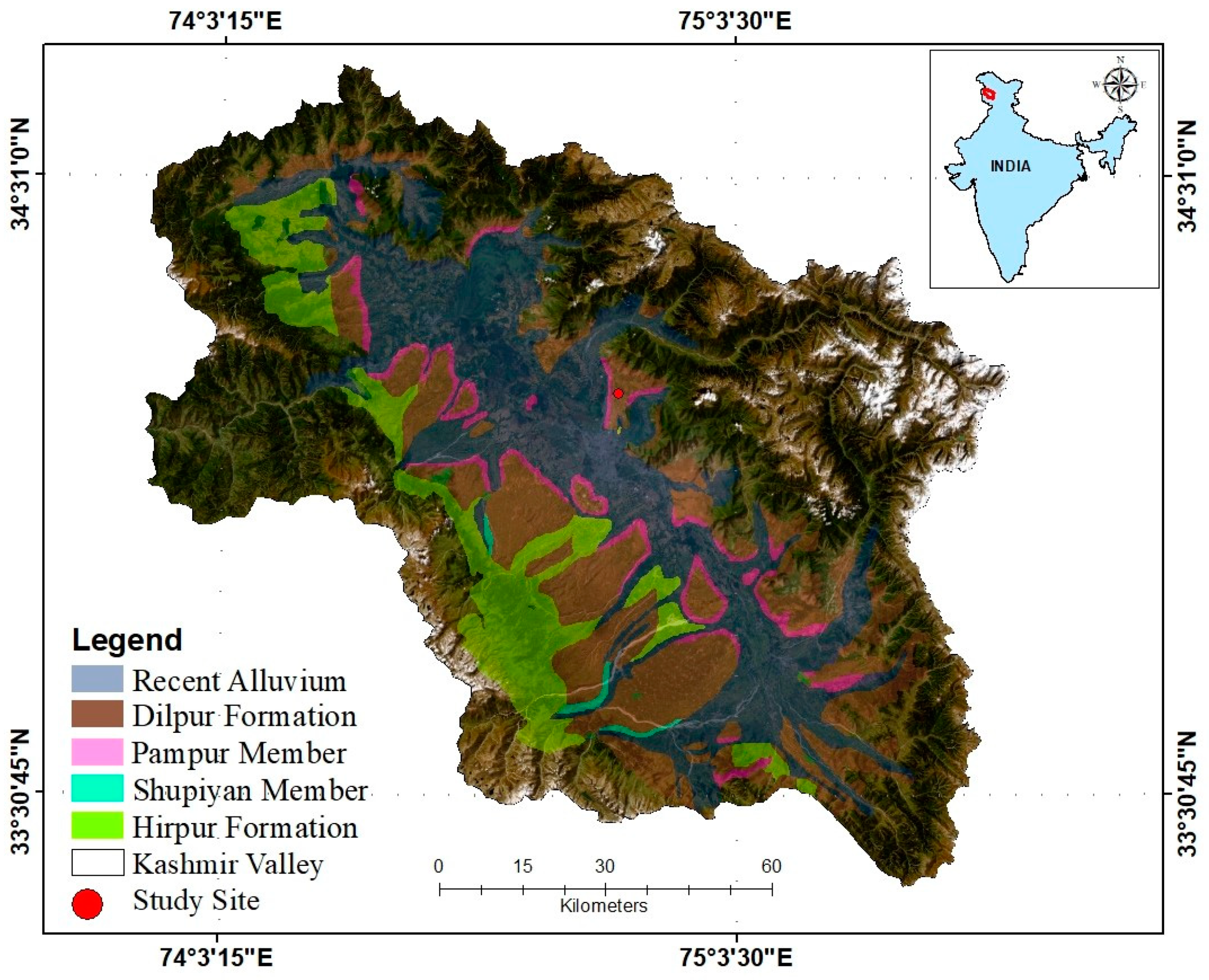
Figure 2.
High-resolution photograph and litholog of the Makaibagh section.
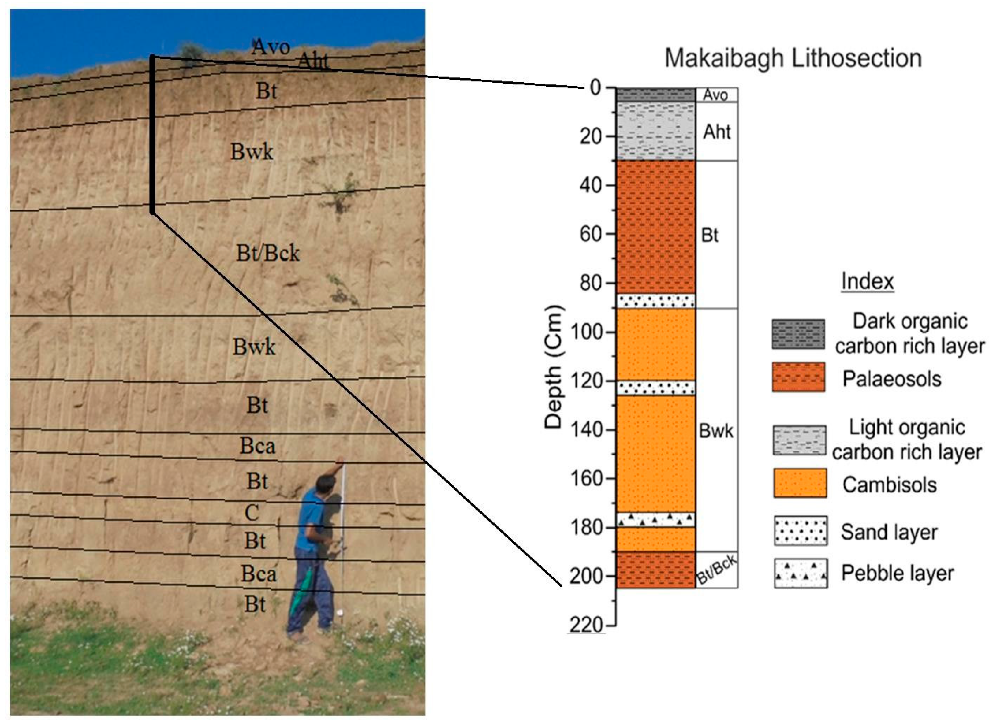
Figure 3.
(a) Detailed lithosection with ages, depth-wise variation in sediment grain size, (b) sand %, (c) silt %, (d) clay %, and (e) age-depth model showing sedimentation rates.
Figure 3.
(a) Detailed lithosection with ages, depth-wise variation in sediment grain size, (b) sand %, (c) silt %, (d) clay %, and (e) age-depth model showing sedimentation rates.

Figure 4.
Temporal variation of different geochemical indices a) Al/Ti, b) Si/Ti, c) Mg/Ti, d) Ca/Ti, e) Na/Ti and f) K/Ti.
Figure 4.
Temporal variation of different geochemical indices a) Al/Ti, b) Si/Ti, c) Mg/Ti, d) Ca/Ti, e) Na/Ti and f) K/Ti.
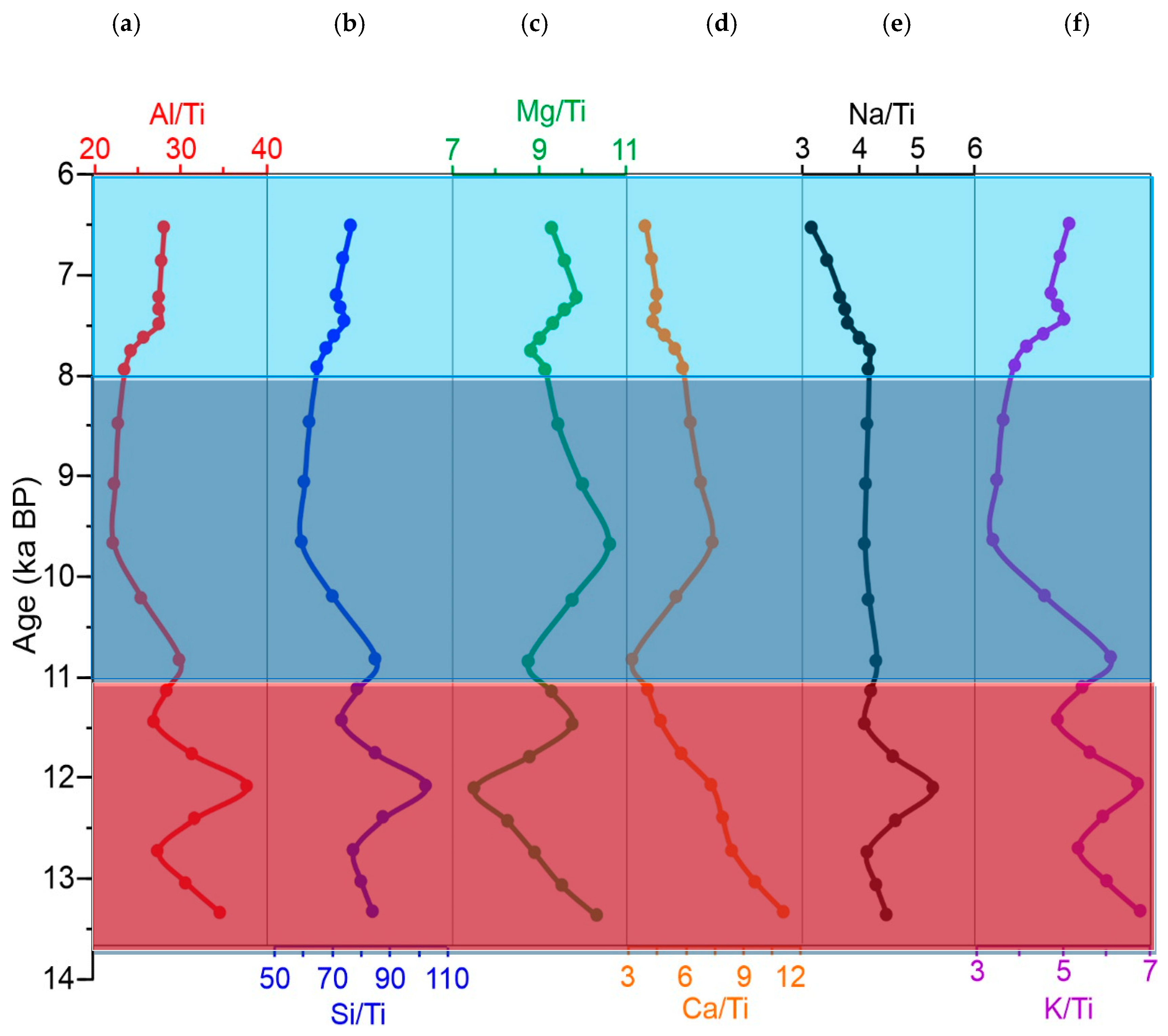
Figure 5.
Temporal variation of a) TOC, b) N, c) C/N, d) CaCO3, and e) δ13C values.
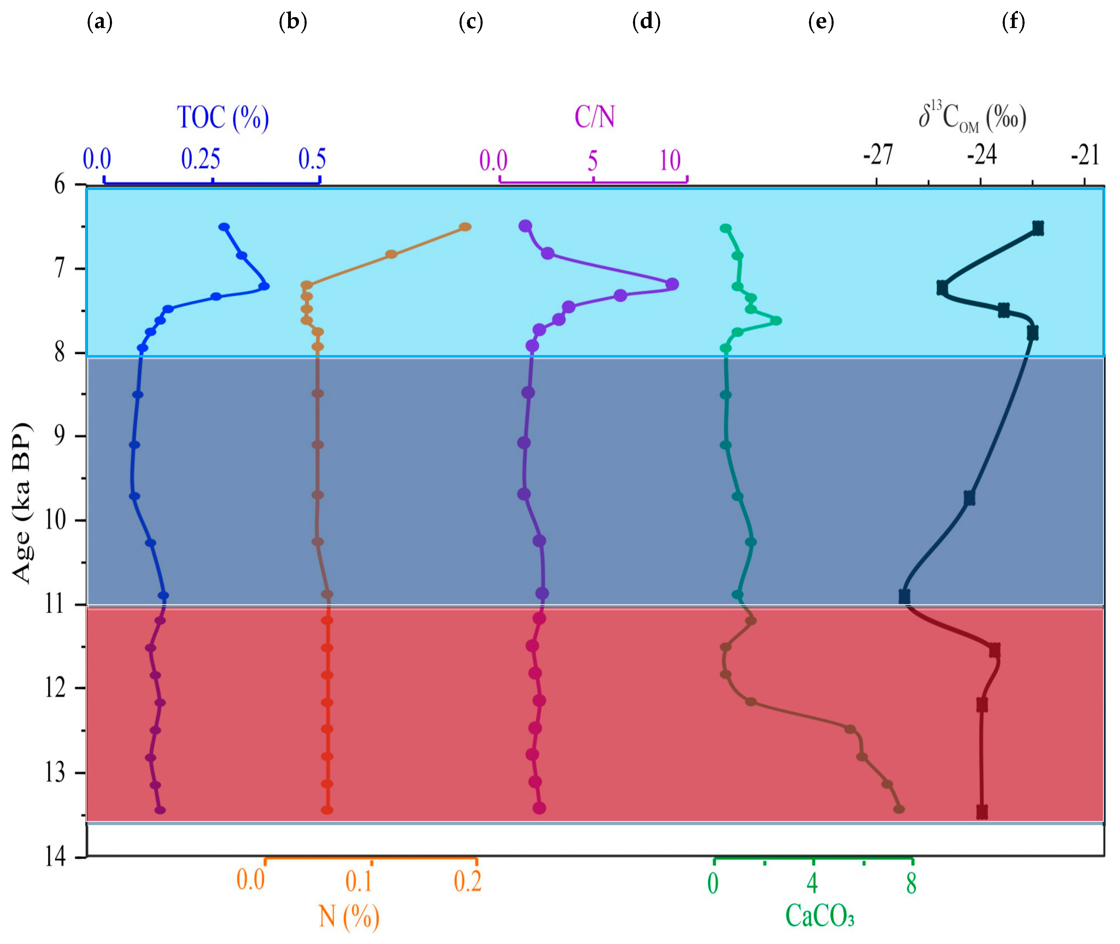
Figure 6.
ACNK (Al2O3–CaO*+Na2O–K2O) ternary diagram [41] for the studies section, with comparisons to other loess- palaeosol deposits [e.g., 5,48]. The diagram also includes the average composition of the Upper Continental Crust [UCC; 56] and Indian post-Archean Shale [IPAS; 57] for reference.
Figure 6.
ACNK (Al2O3–CaO*+Na2O–K2O) ternary diagram [41] for the studies section, with comparisons to other loess- palaeosol deposits [e.g., 5,48]. The diagram also includes the average composition of the Upper Continental Crust [UCC; 56] and Indian post-Archean Shale [IPAS; 57] for reference.
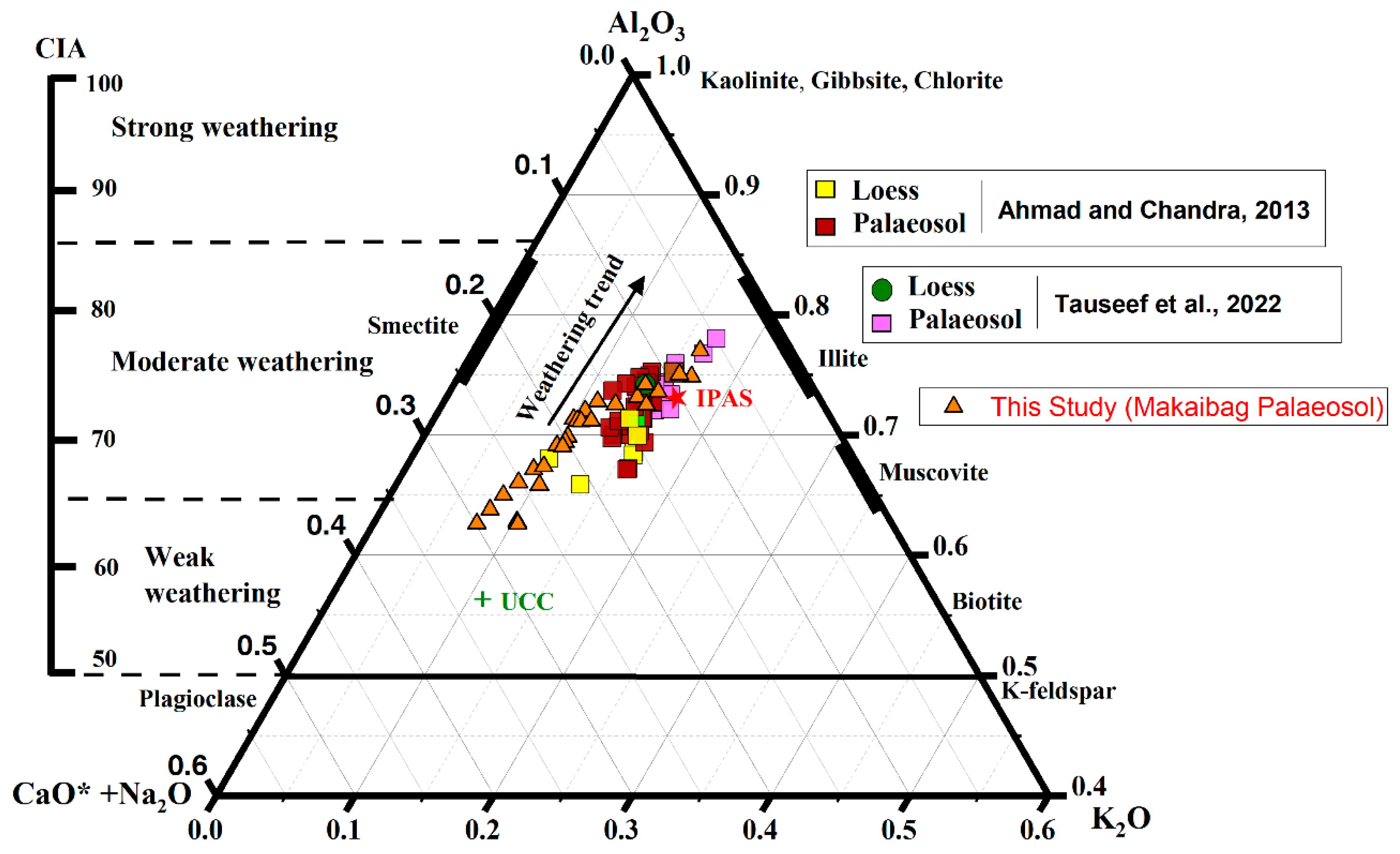

Table 1.
Depth-wise stratigraphic description of the Makaibagh litho-section.
| Depth (cm) | Thickness (cm) | Age (ka) | Horizon | Description |
|---|---|---|---|---|
| 1−5 | 5 | <6.5 | Avo | Dark brown (10YR 2/2, 4/2), organic carbon rich, silt with root traces and pores, with high moisture content. |
| 6−30 | 25 | 12 − 6.5 | Aht | Dark brown (10YR 3/2, 3/1) with higher organic carbon content, with visible root channel filled with fine silt. Well-developed ped with a gradational contact with the lower horizon. |
| 31−90 | 60 | Bt | Dull brown (7.5 YR 5/3, 5/4), moderately developed palaeosol with bedded sand layers, low CaCO3 content and contains significant amount of sand content. This horizon developed during MIS-1. | |
| 91−190 | 100 | Bwk | Light gray (7.5 YR 8/1), Weakly altered sediments with high CaCO3 and pedogenic nodules, N2 nodules and bedded sand horizons. A pebble/ gravel bed (3-4 cm thick) is deposited at the base of this unit. A sharp contact with the lower horizon. | |
| 191−205 | 15 | 13.4 − 12 | Bt/Bck | Greyish brown or gray (7.5 YR 8/2), weakly developed palaeosol with very high CaCO3 content |
Table 2.
Calibrated AMS 14C dates with 2σ uncertainty (95.4 % Probability).
| Lab id. | Depth (cm) | Libby Age (years BP) | Calibrated Age (years BP) | (µ) Calibrated (years BP) |
|
|---|---|---|---|---|---|
| from | to | ||||
| 17C1149 | 25 | 6422 ±41 | 7307 | 7164 | 7202 ±41 |
| 17C1150 | 75 | 6849 ±41 | 7933 | 7771 | 7892 ±42 |
| 17C1151 | 125 | 9639 ±53 | 10960 | 10708 | 10830 ±68 |
| 17C1153 | 205 | 11521 ±48 | 13488 | 13308 | 13396 ±51 |
Table 3.
Variation in Total organic carbon (TOC) (%), Carbon (C) (%), Nitrogen (N) (%), C/N ratio, CaCO3 content (%) and δ13C-VPDB (‰) in the Makaibagh litho-section.
Table 3.
Variation in Total organic carbon (TOC) (%), Carbon (C) (%), Nitrogen (N) (%), C/N ratio, CaCO3 content (%) and δ13C-VPDB (‰) in the Makaibagh litho-section.
| Sample id |
Depth (cm) |
Age (ka) |
TOC (%) |
C (%) |
N (%) |
C/N | CaCO3 (%) |
δ13C (VPDB, ‰) |
|---|---|---|---|---|---|---|---|---|
| MAK-1 | 5 | 6.5 | 0.28 | 0.28 | 0.19 | 1.47 | 0.50 | -22.47 |
| MAK-2 | 15 | 6.8 | 0.32 | 0.32 | 0.12 | 2.67 | 1.00 | |
| MAK-3 | 25 | 7.2 | 0.37 | 0.37 | 0.04 | 9.25 | 1.00 | -25.13 |
| MAK-4 | 35 | 7.3 | 0.26 | 0.26 | 0.04 | 6.50 | 1.50 | |
| MAK-5 | 45 | 7.5 | 0.15 | 0.15 | 0.04 | 3.75 | 1.50 | -23.42 |
| MAK-6 | 55 | 7.6 | 0.13 | 0.13 | 0.04 | 3.25 | 2.50 | |
| MAK-7 | 65 | 7.8 | 0.11 | 0.11 | 0.05 | 2.20 | 1.00 | -22.63 |
| MAK-8 | 75 | 7.9 | 0.09 | 0.09 | 0.05 | 1.80 | 0.50 | |
| MAK-9 | 85 | 8.5 | 0.08 | 0.08 | 0.05 | 1.60 | 0.50 | |
| MAK-10 | 95 | 9.1 | 0.07 | 0.07 | 0.05 | 1.40 | 0.50 | |
| MAK-11 | 105 | 9.7 | 0.07 | 0.07 | 0.05 | 1.40 | 1.00 | -24.38 |
| MAK-12 | 115 | 10.2 | 0.11 | 0.11 | 0.05 | 2.20 | 1.50 | |
| MAK-13 | 125 | 10.8 | 0.14 | 0.14 | 0.06 | 2.33 | 1.00 | -26.19 |
| MAK-14 | 135 | 11.2 | 0.13 | 0.13 | 0.06 | 2.17 | 1.50 | |
| MAK-15 | 145 | 11.5 | 0.11 | 0.11 | 0.06 | 1.83 | 0.50 | -23.69 |
| MAK-16 | 155 | 11.8 | 0.12 | 0.12 | 0.06 | 2.00 | 0.50 | |
| MAK-17 | 165 | 12.1 | 0.13 | 0.13 | 0.06 | 2.17 | 1.50 | -24.03 |
| MAK-18 | 175 | 12.4 | 0.12 | 0.12 | 0.06 | 2.00 | 5.50 | |
| MAK-19 | 185 | 12.8 | 0.11 | 0.11 | 0.06 | 1.83 | 6.00 | |
| MAK-20 | 195 | 13.1 | 0.12 | 0.12 | 0.06 | 2.00 | 7.00 | |
| MAK-21 | 205 | 13.4 | 0.13 | 0.13 | 0.06 | 2.17 | 7.50 | -24.04 |
| Minimum | 0.07 | 0.07 | 0.04 | 1.40 | 0.50 | -26.19 | ||
| Maximum | 0.37 | 0.37 | 0.19 | 9.25 | 7.50 | -22.47 | ||
| Mean | 0.15 | 0.15 | 0.06 | 2.67 | 2.10 | -24.00 | ||
| SD | 0.08 | 0.08 | 0.03 | 1.83 | 2.22 | 1.10 |
Disclaimer/Publisher’s Note: The statements, opinions and data contained in all publications are solely those of the individual author(s) and contributor(s) and not of MDPI and/or the editor(s). MDPI and/or the editor(s) disclaim responsibility for any injury to people or property resulting from any ideas, methods, instructions or products referred to in the content. |
© 2025 by the authors. Licensee MDPI, Basel, Switzerland. This article is an open access article distributed under the terms and conditions of the Creative Commons Attribution (CC BY) license (http://creativecommons.org/licenses/by/4.0/).
Copyright: This open access article is published under a Creative Commons CC BY 4.0 license, which permit the free download, distribution, and reuse, provided that the author and preprint are cited in any reuse.


