
Submitted:
13 March 2025
Posted:
14 March 2025
You are already at the latest version
Abstract
We modelled the water level variations in a protected playa-lake system (La Ratosa Natural Reserve, S Spain) comprising two adjacent playa-lakes: La Ratosa and Herriza de los Ladrones. For this pourpose, daily water balances were applied to reconstruct the water level. Model results were validated using actual water level monitoring over the past 20 years. We surveyed post-Pliocene geological structures in the endorheic watershed to investigate lake nucleation and to improve the hydrogeological model. Additionally, we investigated the groundwater level evolution in nearby aquifers, which have been profusely affected by groundwater exploitation for domestic and agricultural use. Then, the RCP 4.5 and RCP 8.5 climate change scenarios were applied to forecast the future of this lake system. We found that the playa-lake hydroperiod will shorten, causing the system to shift from seasonal to ephemeral, which appears to be a general trend in this area. However, the impact on La Ratosa-Herriza de los Ladrones system would be likely more severe due to local stressors, such as groundwater withdrawal for urban demand and agriculture, driving to the system to the complete desiccation of for extended periods. These results highlight the sensitivity of these protected ecosystems to changes in the watershed´s water balance and underscore the urgent need to preserve watersheds from any form of water use, other than ecological purposes. This approach aims to support informed decision-making to mitigate adverse impacts on these fragile ecosystems, ensuring their ecological integrity in the context of climate change and increasing water demand for various uses.
Keywords:
hydrology
; climate change
; wetland
; ecosystem preservation
1. Introduction
The origin and evolution of playa lakes are often influenced by both the presence of low-permeability rocks and active structures that may enclose endorheic watersheds. These playa lakes, which have no surface outlets, periodically fill with water to form temporary ponds. In the Mediterranean climate, their water balance is negative, causing them to typically dry out during the summer. This delicate hydrological balance makes temporary playa lakes highly vulnerable to hydrological alterations in their watershed, particularly those caused by both human activities, like groundwater withdrawal, and shifts in local precipitation patterns due to climate change. Due to their high sensitivity, temporal playa-lakes serve as reliable indicators of both long-term environmental changes and local stressors, such as groundwater withdrawal on their watersheds [16].
The establishment of effective protection areas around these wetlands has traditionally been the primary approach to preventing or mitigating the most immediate threats to the survival of these ecosystems. However, these protection measures are generally limited to the wetland’s floodplain, limiting the consideration and monitoring of potential impacts within the broader watershed, such as groundwater withdrawal. The importance of groundwater in maintaining the hydroperiod of playa lakes has been largely demonstrated [2,7,20,32]. Recently, [29] proved that groundwater contributes significantly (81%) to overall water flux of Ghorra playa, in Tunisia, with implications for the preservation of migratory birds. [18], claimed that in lake Atotonilko (Mexico) urgent public policies must be implemented to rationalize the use of water resources in the basin and ensure the minimum lake storage volume required to sustain its biodiversity.
In the present study we investigated the hydrology of the Nature Reserve “Laguna de la Ratosa”, in the north of the Málaga province (southern Spain), which comprises two adjacent playas, La Ratosa (RaL) and Herriza de los Ladrones (HL) (also called “Castañuela”), as well as a nameless ephemeral pond. Importantly, only the 22,7 hm² of former (RaL) that periodically flood are officially protected as a Reserve (Figure 1). HL playa-lake is outside the protected Reserve Zone and is only surrounded by a low-grade Peripheral Area of Protection (PAP). In 2015, a new Hydrological Protection Zone (HPZ) based on previous hydrological knowledge was proposed instead of the current Peripheral Area of Protection [23]. This new HPZ included the HL playa-lake and the western border of La-Camorra karstic aquifer (Figure 1). As a part of that investigation a monthly water balance was conducted in the playa-lake over a 10-year period (1998-2008), showing a strong correlation with observed water levels, confirming the playa-lake’s vulnerability to hydrological alterations caused by human activities, especially groundwater withdrawal in La-Camorra karstic aquifer.
Despite the protection proposals made in the past, in recent years there has been a rapid deterioration of the wetland ecosystems in the protected area of La Ratosa Nature Reserve, largely due to the intensification of extreme climatic events, rising temperatures, and reduced precipitation. As a result, the water bodies have remained dry for most of the time. Even so, the desiccation periods of these playa-lakes appear to be longer in recent years than those of other wetlands in the region exposed to the same climatic conditions. Thus, it has become necessary to assess the factors conditioning this change in the water bodies’ hydroperiod, evaluating the extent of the impact of groundwater extractions in this regard and reassessing the protection zones accordingly.
With this purpose, this study applies an interdisciplinary methodology with the aim to model the daily hydrological evolution of RaL and HL water level for a 20-year period (2004-2024) and assess the susceptibility to climate change by applying the RCP 4.5 and RCP 8.5 scenarios, evaluating the vulnerability in the simulations. We also analyse the hydrogeological evolution of the La-Camorra aquifer within the Hydrological Protection zone during that period to detect changes in the piezometry and possible shifts in the hydrological regime of the playa-lakes.
Finally, to strengthen information-driven conservation strategies, we compared Andalusian playa lakes with two playas in southern Hungary). Similarly, playa lakes on the Great Hungarian Plain face comparable challenges. Both regions experience a mix of continental and Mediterranean climatic influences, characterized by variable precipitation and high evapotranspiration. They also support specialized biota adapted to ephemeral water bodies, making their comparison valuable for developing conservation strategies in the face of climate change.
2. Study Area
Geological setting of La Ratosa playa-lake system
La Ratosa playa-lake system is located in the external zones of the Betics chain. The Betics form the northern branch of the Gibraltar arc, built up because of the Miocene collision between the Alboran domain and the South Iberian and Maghrebian paleomargins and its tectonic activity still continues [1,24,25,31]. The South Iberian paleomargin is composed of: Triassic claystones, sandstones and evaporites, Jurassic dolostones and limestones and Cretaceous to Paleogene marls and marly-limestones [31]. The external zones of the Betics are deformed into a fold-and-thrust belt detached within the Triassic evaporites. Because of the tectonic load, the Guadalquivir foreland basin formed and was filled by a shallowing-upward sequence from marine to continental, upper Miocene to Holocene sediments [6]. The internal parts of this basin were incorporated to the fold-and-thrust belt due to the outward propagation of the deformation [8,17,25]. Many playa-lakes and lakes develop during the Quaternary on the Betics fold-and-thrust belt [15].
The Ratosa playa-lake system is located in a relative depressed zone within the Betics fold-and-thrust belt, known as the Antequera Depressed Area (ADA; [14]). The ADA, characterized by a roughly flat topography at approximately 450 m a.s.l, is limited by two topographic highs which coincide with two transpressional zones: the Algodonales-Badolatosa shear zone, to the N, and the Torcal shear zone, to the S [14]. The ADA includes some scattered reliefs such as the Humilladero sierra, generated by a compressive bridge that links two post-Tortonian, left-lateral shear zones [14]. The La-Camorra and Mollina ranges, made up of Jurassic limestones, bound the RaL and HL watersheds to the east (Figure 2).
Climatic setting
Climate of the southern Iberian Peninsula is typically Mediterranean, warm and temperate (Csa; Essenwanger, 2001). However, due to its location in the core of the Andalusian countryside, partially separated from the Mediterranean sea by the Betic reliefs, the study area shows a noticeable continental influence, with a wide range of daily and annual temperatures. Temperatures may reach 0ºC in winter and more than 40ºC in summer. Precipitation is 456 mm/yr on average, and it concentrates on autumn and spring. Annual precipitation significantly changes from dry years (c. 300 mm/yr) to wet years (more than 800 mm) (Sierra de Yeguas station; Junta de Andalucía meteorological monitoring system).
Hydrological and hydrogeological setting
La Ratosa playa-lake system is composed of La Ratosa (RaL) playa-lake which is officially protected as a Nature Reserve (orange border in Figure 2), the Herriza de los Ladrones (HL) playa lake, not protected as a Natural Reserve but inside the official Peripheral Area of Protection (PAP, see Figure 2) and an ephemeral nameless pond located in the northern sector. Nowadays both HL and the ephemeral pond are almost completely lost and classified as degraded systems according to hydrological and geochemical criteria [12], although under a natural regime, the system may have included the two playa-lakes and the pond, defining a pseudo-triangular shape with an approx. NNW-SSW long axis (Figure 3C). In fact, during extremely humid periods, both RaL and HR merged forming a single pond. As mentioned above, a Hydrological Protection Zone was proposed a decade ago [23] to try to protect and maintain the hydrological functioning and the ecological integrity of the system. To date, no change has been made in the Natural Reserve’s borders. La-Camorra karstic aquifer consists of Jurassic dolostone breccias, limestones, and marly limestones, forming a carbonate aquifer above a low-permeable unit. Overlaying these materials, there are moderately permeable late Tortonian calcareous sandstone, sands, marls, and Quaternary detrital sediments. Historically, the carbonate aquifer discharged into the Alameda Spring, which has been dry since 1982. Currently, the flow is diverted towards several pumps (some of them, but not all, are shown in Figure 2) which supply water to the village of Alameda. Previous works confirmed the hydrogeological connection between the Mollina and La-Camorra ranges, suggesting they constitute a single carbonate aquifer [8,9,20].
3. Methodology
Water level monitoring
We obtained actual water level from the Junta de Andalucía wetlands monitoring agency both for La Ratosa system and for other lakes (e.g. Archidona Lakes) and playa-lakes (e.g. Campillos playa-lakes) for sake comparison. Water level monitoring was conducted by recording measurements of calibrated staff gauges of the deepest areas of the RaL, HL and the rest of the playa-lakes. Actual data have a centimetric accuracy. Monitoring was carried from January-2005 to February-2025. These data were used to calibrate our model. Moreover, some ortophotographies from IGN (National Geographic Institute) were used to calibrate some parameters.
Water level modelling
The water level modelling has been applied previously to other lakes and playa-lakes in southern Spain (e.g. [14,23]). For modelling, we used climatic parameters (precipitation, average daily temperature and ETº) from the Sierra de Yeguas station; Junta de Andalucía meteorological monitoring system, located 15 km to the SE from La Ratosa playa-lake. We performed the modelling for 20 years that includes a wet period from 2010 to 2013, when RaL and HL merged. This modelling is based on changes in water level with depth and time, thus we produced 2D water balances of both playa-lakes. Due to the presence of low permeability rocks on the playa-lake beds: Triassic claystones, the lake water storage (Hs) may be simplified into:
Hs = P + BD ± O–E,
Water inputs are precipitation (P), basin discharge (BD) and overflows from another wetland (O). P is the increase in the lake level due to precipitation directly obtained from the weather station. BD is calculated by means of a soil water balance. To do that, we used the TRASERO software to calculate the effective rainfall and we chose a water holding capacity of 220 mm according to clayey soils. This value is similar to that one used for other works (e.g. [23; 14]). Once the effective rainfall is calculated, we multiplied by the watershed/average flooded surface (W/AFS) to obtain the increase in mm of the playa-lake water level, as in previous works [23]. Most years, the HL and RaL do not behave as an only wetland, then we made calculations separately. In RaL playa-lake W/AFS relationship is 24, whilst in HL relationship is 16 (Table 1). During wet years (from 2010 to 2013), the flooded surface considerably increases and RaL and HL playa-lakes merged into one water body (Figure 3). For this period, we used a W/AFS of 15 for both playa-lakes. The RaL bed is located at 448 m. During wet years, the RaL water level increases and when it reaches 3.3 m, this playa-lake merges with HL.
The main water output for these water bodies is evaporation (E). It is calculated as the water output as direct evaporation from an open water body. We used the potential evapotranspiration (PET) by the Hargreaves method [13] calculated by means of the maximum and minimum temperature record. We corrected these values by multiplying by 1.15 to calibrate direct evapotranspiration from an open water body as in previous works [14,23]. The result of the water balance (Hs) is added to the lake water level of the previous day. We calibrated the model using ordinary least squares method by comparing actual and modelled data.
Climate change scenarios
Once the models were validated, we applied climate change scenarios for the period from 2030 to 2060. To do that, we performed daily water balances, and we calculated the playa-lake water storage (Hs) using eq. 1. For these calculations, we obtained climatic parameters from [19]. We used two IPCC climate change scenarios: RCP 4.5 and 8.5, as an intermediate mitigation and as more extreme climate change scenarios. Global temperature is projected to increases between 1.4 and 2 ºC and between 2.6 and 4.8 ºC for 2100 for the RCP 4.5 and 8.5, respectively [30]. We assumed a water level of 1 m and 0.5 m for the RaL and HL, respectively, in 2030 as the initial condition for the modelling process. These values are the average water level during the studied period.
Structural data
To improve the hydrogeological model, we collected field data and we improved previous geological maps. We obtained these data from the Sierra de la Camorra and Mollina, which are within La Ratosa system watershed. We focused on structures that affect post-Pliocene sediments.
4. Results
Geological results
The Sierra de la Camorra and Mollina mountain ranges are composed of Jurassic dolostones and limestones with bedding dipping 15-60º towards the NW (Figure 4a). These ranges are limited to the NW by fault surfaces striking N10ºE to N80ºE that mostly dip 65-90º towards the SE (Figure 4b). Slicklines together with shear-sense criteria show that they are reverse faults with a subordinate dextral strike-slip movement. These faults cut and displace quaternary soils and piedmont deposits. Towards the W of RaL, a kilometric scale, NE-SW antiform folds Miocene units (Figure 4a).
To improve the structural information of the area, we have interpreted two shallow wells (up to 80 m depth) located in the studied area: Ratosa and Serafina wells (see location in Figure 4A). Both well logs show Jurassic limestones from 80 to 20-40 m, and Quaternary deposits (soils, piedmont and lake deposits in Ratosa well, only soils in Serafina well) on top (Figure 4c and d). In Serafina well, upper Miocene marls appear between the limestones and the Quaternary soils. Consequently, the Jurassic limestones sheet that crop out in the la Camorra and Mollina mountain ranges continues towards the NW, underlying the RaL. It is noteworthy that the long axis of the flooded area is approx. N45ºE, thus it runs subparallel to the average fault and fold-axis orientation (Figure 4).
Water level variations, modelling and validation
In this section we describe the results derived from the water level monitoring, modelling and validation. We distinguished a wet period according to P and effective rainfall values from 2010 to 2013 (See Appendix). During this period, precipitation exceeds 600 mm/yr. During average years, precipitation is 450 mm/yr on average, effective rainfall is lower than 20 mm/yr and evaporation is approx. 1,500 mm/yr, then playa-lakes dry up during summer (from June to October; Figure 5 and Figure 6). In the case of RaL water level may reach 1.5 m, whilst in HL does not reach 1 m. This is due to the lower W/AFS relationship of HL (Table 1). Both behave as seasonal playa-lakes. During dry years, both playa-lakes remain dry most of days (ephemeral water bodies), even during autumn, spring and winter (Figs. 5 and 6). It is due to the low precipitation values (lower than 400 mm/y) and effective rainfall (lower than 20 mm/y).
In Figure 5 the hydrograms of RaL (Figure 5a) and HL (Figure 5b) during the studied period (2005-2025) is displayed, as well as the linear regression of the water level. During the wet period, from January 2010, the RaL water level quickly increased up to 3.3 m above the playa-lake bed. When this water level is reached, both playa-lakes merge into a single water body (Figure 3c and Figure 5c). Even though they are merged, a difference of c. 35 cm in total depth is observed in the hydrograph of both playa-lakes (Figure 5c). This difference between RaL and HL is due to the different elevation of the lakebed (448 m a.s.l. and 448.33 m a.s.l., respectively).
Note that HL is dry since 2014 and RaL is dry since 18/04/2023 although the total precipitation in the area from April 2023 to January 2025 has been 630 mm (Figure 5d).
Figure 6 shows the water level modelling of the RaL and HL. We showed in yellow when both playa-lakes are connected. Towards the N, we observed another flooded area during wet years, although we do not have monitoring data. This flooded area is separated from the RaL and HL by a road (Figure 3). This flooded area also remained flooded during this wet period. All these three water bodies probably formed an only playa-lake prior to human activity. It should be noted that there is a sharp contrast of the water level between average and wet periods (Figure 6).
Water level modelling adjusts to actual data, except for some periods. For example, actual data are above modelled data during the wet period in RaL (Figure 6). Statistical analysis shows a strong relationship in both cases (R² > 0.97; Figure 7). Once the models were validated, we applied climate change scenarios.
Climate change scenarios
In both, RCP 4.5 and 8.5 climate change scenarios, long dry periods with evaporation rates higher than 2000 mm/yr alternated with periods with extreme precipitation events, where precipitation may exceed 100 mm/day. Average precipitation from 2030 to 2060 (487 mm/yr for the RCP 4.5 and 533 mm/yr for the RCP 8.5) is slightly higher than in the studied period 2005-2025: 485 mm/yr.
The results obtained from the application of climate change scenarios RCP 4.5 and 8.5 are similar: both playa-lakes behaved as an ephemeral/seasonal water bodies except for extremely wet periods (Figure 8). The results of the water level model are actually similar for both models. During dry periods (e.g. from 2030 to 2038), both RaL and HL dry even during spring, when the lake high stand is expected. In contrast, during wet periods (e.g. from 2045 to 2048), RaL and HL may not dry out during summer, and they could merge into a single body during some weeks. Therefore, the water level variability and hydroperiod obtained from the application of climate change scenarios are similar to those observed during the studied period (from 2005 to 2025; Figure 8). However, the hydroperiod will probably decrease.
Hydrogeological evolution of La-Camorra aquifer
A hydrogeological connection between la-Camorra and Mollina aquifers has been established previously, as will be discussed later. Such systems constitute a single karstic aquifer, so a hydrogeological affection to the former, will affect the latter. Figure 9 shows the 1993-2025 piezometric evolution in the Santillan piezometer, located in the Mollina mountain range. Intensive groundwater pumping has led to the depletion of groundwater levels and the reversal of groundwater flow direction.
The combined analysis of the Santillan piezometric evolution, geological field observations and lithological well logs allowed us to develop the following conceptual hydrogeological model (Figure 10). In a natural regime (stage a) the playa lake should have been a discharge system, and several springs may have drained the karstic aquifer. In that stage, the RaL received surface runoff and subsurface groundwater discharge onto the system. The hydroperiod was seasonal due to the Mediterranean climate. This natural regime changed after 2015 (Figure 10; stage b) when several springs dry and likely subsurface discharge into the RaL system may have ceased also. Concurrently, a Hydrological Protection Zone was proposed but no action took place to protect the hydrology of the system. Since 2015, HL ceased to receive water and RaL was flooded only during sporadically heavy rains, changing its hydroperiod from seasonal to temporary. From 2015 to 2020, the groundwater level progressively dropped, such that a hydraulic inversion may have taken place in the system. Accordingly, the RaL is now, probably, a recharge system, at least during low-level periods. This hypothetical situation can be viewed in Figure 10, stage c (flow lines from the playa-lake to the aquifer). In such situation, RaL has shifted to an ephemeral playa-lake and HL has shifted to a dry area, susceptible to be transformed into agricultural land.
5. Discussion
Origin and hydrogeological evolution of la Ratosa system
Regarding the geological nucleation and origin of la Ratosa system, it probably formed as a single water body at the western slope of the la Camorra range, later split into three water bodies because of human activity [23]. Previous studies suggest that this system could overflow toward the Fuente de Piedra playa-lake, to the south [14]. This situation might have occurred at RaL early stages (ca. 15,000 yrs BC, as suggested by unpublished 14C ages of the RaL sediments), whereas nowadays the la Camorra system overflows toward the Atlantic drainage network. The flooded area of this system shows a pseudo-triangular geometry in plain view, whose long axis runs NNE-SSW. This elongation is subparallel to the studied reverse faults at the NW boundary of the la Camorra range and to the antiform axis affecting upper Miocene units to the NW of the RaL (Figure 4). These faults cut Quaternary soils and condition the eastern RaL water divide (Figure 1), and the antiform constitutes the western RaL water divide (Figure 1 and Figure 4). This antiform could be interpreted as a fault bend fold associated with a blind NW-verging thrust [27], similar to the la Camorra reverse fault.
Figure 11 shows the evolution of RaL, Campillos (CAM) playa-lakes and Archidona (ARC) lakes evolution from January 2023 to October 2024. In April 2023 RaL dried up and remained dry through 2023 and 2024. The rest of the playa-lakes systems of the Antequera Depression Area (ADA) were flooded for four months (February to May 2024) and also from September 2024 onwards. Note that HL has remained dry since 2015 to date (2025) and that it has been transformed into a wheat field in recent years (Figure 12). It must be noted that the hydrological functioning of Campillos lakes and the RaL system was identical, as stated in the literature [23]. A detailed hydrogeological analysis made by [23] showed that RaL and HL could be classified as a discharge hydrological system. A monthly water balance was conducted over a 10-year period (1998-2008), showing a good correlation with observed water levels, although modelling showed that RaL may have a slightly longer hydroperiod than the hydroperiod actually measured. This study highlights the playa lake’s vulnerability to hydrological alterations in its watershed caused by human activities, such as those related to land-use change, and especially groundwater withdrawal for urban demand and agriculture. In this investigation it is concluded that the RaL system has been affected by a hydrological alteration in the last years, as depicted in Figure 10, due to an intense groundwater exploitation of the Mollina-La Camorra aquifer, that led to a probable inversion of the hydrological gradient. Our interpretation is reinforced with the physicochemical characteristics of soil profile from this system. Lake sediments from RaL present high electrical conductivity (RC), typical of a saline-alkali system, whereas those from HL show high pH but low EC, indicating and altered hydrological cycle [12]. Similar results concerning the affection of the Fuente de Piedra hydrological regime have been proposed by [20].
Comparison with Great Hungarian Plain playa-lakes
To enhance information-driven conservation strategies, we compared the Andalusian playa-lakes with two playa-lakes studied here with two playa-lakes located on the Great Hungarian Plain, which face similar problems. Both regions have continental to Mediterranean climatic influences, with variable precipitation and high evapotranspiration and host-specialized biota adapted to ephemeral water bodies, making their comparison relevant for conservation strategies under climate change.
Figure 12.
Hungarian playa-lakes: lake Fehér in Kardoskut.
A thorough study on Lake Fehér in Kardoskút was conducted by [3], focusing on its water balance, the interaction between groundwater and surface water, and related environmental impacts. Its water regime is primarily dependent on precipitation and groundwater flow, exhibiting seasonal variations and long-term trends influenced by climate change and human activities. These anthropic modifications include water regulation and infrastructure development, such as drainage channels and fish farming facilities. Key issues highlighted are the declining groundwater levels, increasing salinity, and the ongoing aridification of the surrounding region. The study concludes that sustainable water management is crucial to preserving the lake’s ecological functionality. Continuous monitoring of water levels and quality was recommended to mitigate the adverse effects of climate change and anthropogenic activities [3].
The original wetland conditions around the alkaline Lake Fehér in Szeged lake system are also threatened by inadequate management, excess groundwater withdrawal for agriculture and climate change [11]. Aridification is ongoing in the Danube-Tisza Interfluve, as indicated by meteorological data from Szeged meteorological station, with the most pronounced effects in the Sand Ridge (Homokhátság) zone, which adversely affects playa-lakes in the region. The primary factor contributing to salinization – a process that is crucial for playa ecosystems - is the near-surface groundwater; however, the groundwater. In this regard, the groundwater level in the Danube and Tisza Interfluve is declining [3], leading to the degradation of naturally sodic areas [11,21,22,28], the same process that is observed in the case of the HL [12]. The combined effect of aridification and the declining groundwater table promotes the long-term leaching of salts from the near-surface layer, which consequently contributes to the formation of steppe landscapes [26]. These findings underscore the extreme vulnerability of these ecosystems to human activities and emphasize the need for scientifically based protection measures. The shared challenges of these ecosystems offer valuable insights into the complex interactions between hydrology, land use, and climate change, ultimately informing more resilient management practices for these vulnerable systems. The first and most important step is returning to historic hydrological functioning [5]. The protection of the watershed and the recharge zones by monitoring as well as the regulation of water extraction and use, land-use changes and the presence of pollutants are essential. It is very important to highlight that the ecosystem of playa-lakes depends heavily on groundwater chemistry [10]. Additionally, restoration measures should focus on rehabilitating already degraded aquatic ecosystems, such as the HL. Wetland restoration aims to reverse the degradation of wetlands and enhance their ecological functions and integrity focusing on the three fundamental components that define wetlands: hydrology, soils and vegetation [33].
6. Conclusions
The analysis of water level variations and the hydrogeological modelling of La Ratosa Natural Reserve, which includes two playa-lakes (RaL and HL playa-lakes), reveals significant findings. By applying daily water balances and validating them with 20 years of actual measurements, a water level model could be successfully developed. The validated model was then subjected to RCP 4.5 and RCP 8.5 climate change scenarios. Additionally, the groundwater level trends in the area’s aquifers, heavily impacted by domestic and agricultural exploitation, was analysed. The results indicate a reduction in the playa-lake hydroperiod, shifting from seasonal to ephemeral, a trend exacerbated by local stressors, leading to near-complete desiccation and irreversible conditions. This underscores the extreme sensitivity of these protected ecosystems to changes in watershed water balance and highlights the urgent need for establishing Hydrological Protection Zones (HPZs) coinciding with watersheds boundaries and preserving such watersheds from non-ecological water uses. The comparative analysis with similar, yet distant ecosystems facing the same challenges further emphasizes the importance of the conserving these landmarks through the understanding of their hydrological functioning and the adoption of appropriate measures. The study aims to inform decision-making to mitigate adverse impacts on these fragile ecosystems, ensuring their ecological integrity amidst evolving climate conditions and increasing water demand.
Funding
This study was supported by the (1) Tectonic conditioning and climate change effects on the hydrogeological evolution of wetlands and playa-lakes in the southern Spain research project (University of Pablo de Olavide), (2) GYPCLIMATE research project (PID2021-123980OA-I00) Spanish Ministry of Economy and Competitiveness - Regional Development European Fund (FEDER), (3) the project PGC2018-100914-B-I00, funded by the Ministerio de Ciencia e Innovacíon (Spanish Government)/AEI/10.13039/501100011033/ERDF, (4) the project UPO-1259543, funded by the Consejería de Economía, Conocimiento, Compañías y Universidad (Andalusian Government)/ERDF and (5) „Monitorizacion hidrológica y modelización de la relación laguna-acuífero en los mantos eólicos de Doñana. Seguimiento y ampliación del inventario” (Agreement between the Guadalquivir River Basin Authority and the University Pablo de Olavide). Dr. F.G acknowledges the Ramón y Cajal fellowship, RYC2020-029811-I and the grant PPIT-UAL, Junta de Andalucía-FEDER 2022-2026 (RyC-PPI2021-01).
References
- Azañón, J. M., Perez-Pena, J. V., Giaconia, F., Booth-Rea, G., Martinez-Martinez, J. M.,; Rodríguez-Peces, M. J. Active tectonics in the central and eastern Betic Cordillera through morphotectonic analysis: the case of Sierra Nevada and Sierra Alhamilla. Journal of Iberian Geology 2012, 38(1), 225–238. [Google Scholar]
- Beltrán, M., Moral, F.,; Rodríguez-Rodríguez, M. Changes in the hydrological functioning of a playa-lake complex under increasing agricultural pressures (A ndalusia, S outhern S pain). Water and Environment Journal 2012, 26(2), 212–223. [Google Scholar]
- Biró, M., Révész, A., Molnár, Zs.,; Horváth, F. Regional habitat pattern of the Danube–Tisza Interfluve in Hungary, I: The landscape structure and habitat pattern; the fen and alkali vegetation. Acta Botanica Hungarica 2007, 49, 267–303. [Google Scholar] [CrossRef]
- Busa-Fekete, B., Hegyi, R.,; Szanyi, J. The hydrogeological aspects of Lake Fehér, Kardoskút, Southern Hungary. Acta Mineralogica-Petrographica 2003, 44, 35–41. [Google Scholar]
- Daniel, D. W.; Smith, L. M.; McMurry, S. T.; LaGrange, T.; Stutheit, R.; Tangen, B. A.; Dahl, C. F. Greenhouse Gas Fluxes and Carbon Storage Dynamics in Playa Wetlands: Restoration Potential to Mitigate Climate Change. Conservation Effects Assessment Project (CEAP) - Wetlands, Science Note, United States Department of Agriculture (USDA), Natural Resources Conservation Service (NRCS), March 2016. 7p. 2016. [Google Scholar]
- Garcia-Castellanos, D., Fernandez, M.,; Torné, M. Modeling the evolution of the Guadalquivir foreland basin (southern Spain). Tectonics 2002, 21(3), 9–1. [Google Scholar]
- Gil-Márquez, J. M., Andreo, B.,; Mudarra, M. Comparative analysis of runoff and evaporation assessment methods to evaluate wetland–groundwater interaction in Mediterranean evaporitic-karst aquatic ecosystem. Water 2021, 13(11), 1482. [Google Scholar] [CrossRef]
- González-Castillo, L., Galindo-Zaldívar, J., Pedrera, A., Martínez-Moreno, F. J.,; Ruano, P. Shallow frontal deformation related to active continental subduction: structure and recent stresses in the westernmost Betic Cordillera. Terra Nova 2015, 27(2), 114–121. [Google Scholar]
- González-Ramón, A., Pedrera, A., Martos-Rosillo, S., de Cisneros, C. J., Ruiz-Constán, A.,; Gázquez, F. Constraints on the evolution of sulfuric acid speleogenesis within carbonate rocks partially covered by evaporites (Sierra de Mollina, southern Spain). Geomorphology 2021, 390, 107866. [Google Scholar]
- Gurdak, J. J.; Roe, C. D. Recharge Rates and Chemistry Beneath Playas of the High Plains Aquifer—A Literature Review and Synthesis. U.S. Geological Survey Circular 1333. Prepared in cooperation with Playa Lakes Joint Venture. 39p. 2009. [Google Scholar]
- Halmos, L., Bozsó, G.,; Pál-Molnár, E. Alkaline lake system in Danube and Tisza interfluve (Szeged, HU) – Climate change and landscape degradation. Visegrad Journal on Bioeconomy and Sustainable Development 2014, 3(2), 77–81. [Google Scholar] [CrossRef]
- Halmos, L., Delgado Rodríguez, J. M., Rodríguez Rodríguez, M., Jiménez Bonilla, A.,; Díaz Azpiroz, M. Physicochemical characteristics of playa-lake sediments located in the western External Betics. 2022. [Google Scholar]
- Hargreaves, G. H.,; Samani, Z. A. Reference crop evapotranspiration from temperature. Applied engineering in agriculture 1985, 1(2), 96–99. [Google Scholar]
- Jiménez-Bonilla, A., Martegani, L., Rodríguez-Rodríguez, M., Gázquez, F., Díaz-Azpíroz, M., Martos, S.,; Expósito, I. The role of neotectonics and climate variability in the Pleistocene-to-Holocene hydrological evolution of the Fuente de Piedra playa lake (southern Iberian Peninsula). Hydrology and Earth System Sciences 2024, 28(23), 5311–5329. [Google Scholar]
- Kohfahl, C., Rodriguez, M., Fenk, C., Menz, C., Benavente, J., Hubberten, H., ...; Pekdeger, A. Characterising flow regime and interrelation between surface-water and ground-water in the Fuente de Piedra salt lake basin by means of stable isotopes, hydrogeochemical and hydraulic data. Journal of Hydrology 2008, 351, 170–187. [Google Scholar]
- Labbe, J., Celle, H., Devidal, J., Albaric, J.,; Mailhot, G. Combined Impacts of Climate Change and Water Withdrawals on the Water Balance at the Watershed Scale—The Case of the Allier Alluvial Hydrosystem (France). Sustainability 2023. [Google Scholar]
- Marín-Lechado, C., Pedrera Parias, A., Ruiz Constán, A., Peláez Montilla, J. A.,; González Ramón, A. Deformation pattern of the Eastern Guadalquivir foreland basin (Southern Spain). 2018. [Google Scholar]
- Meza-Rodríguez, D., Anda, J.,; Shear, H. Lake Atotonilco: A first approach to determining the minimum lake level necessary to sustain its biodiversity. Annals of the American Association of Geographers 2023, 113(10), 2318–2332. [Google Scholar]
- Montes-Vega, M. J., Guardiola-Albert, C.,; Rodríguez-Rodríguez, M. Calculation of the SPI, SPEI, and GRDI Indices for Historical Climatic Data from Doñana National Park: forecasting climatic series (2030–2059) using two climatic scenarios RCP 4.5 and RCP 8.5 by IPCC. Water 2023, 15(13), 2369. [Google Scholar] [CrossRef]
- Pedrera, A., Martos-Rosillo, S., Galindo-Zaldívar, J., Rodríguez-Rodríguez, M., Benavente, J., Martín-Rodríguez, J. F.,; Zúñiga-López, M. I. Unravelling aquifer-wetland interaction using CSAMT and gravity methods: the Mollina-Camorra aquifer and the Fuente de Piedra playa-lake, southern Spain. Journal of Applied Geophysics 2016, 129, 17–27. [Google Scholar]
- Rakonczai, J., Bódis, K. A környezeti változások következményei az Alföld felszín alatti vízkészleteiben. In Jakucs László, a tudós, az ismeretterjesztő és a művész; L., Jakucs, Ed.; 2002; pp. 227–238. [Google Scholar]
- Rakonczai, J. A klímaváltozás következményei a Dél-Alföldi tájon (A természeti földrajz változó szerepe és lehetőségei) -. The consequences of climate change in the Southern Great Plain (The changing role and possibilities of physical geography). Doctoral dissertation, Hungarian Academy of Sciences, Szeged. 167p. 2013. [Google Scholar]
- Rodríguez-Rodríguez, M., Martos-Rosillo, S., Pedrera, A.,; Benavente-Herrera, J. Ratosa playa lake in southern Spain. Karst pan or compound sink? Environmental Monitoring and Assessment 2015, 187, 1–15. [Google Scholar]
- Ruano, P., Galindo-Zaldívar, J.,; Jabaloy, A. Recent tectonic structures in a transect of the Central Betic Cordillera. Pure and Applied Geophysics 2004, 161(3), 541–563. [Google Scholar]
- Ruiz-Constán, A., Pedrera, A., Galindo-Zaldívar, J., Pous, J., Arzate, J., Roldán-García, F. J.,; Anahnah, F. Constraints on the frontal crustal structure of a continental collision from an integrated geophysical research: The central-western Betic Cordillera (SW Spain). Geochemistry, Geophysics, Geosystems 2012, 13(8). [Google Scholar]
- Sümegi, P.; Lócskai, T.; Hupuczi, J. Late Quaternary palaeoenvironment and palaeoclimate of the Lake Fehér (Fehér-tó) sequence at Kardoskút (South Hungary), based on preliminary mollusc records. Open Geosciences, 2011, 3(1), 43–52. [Google Scholar] [CrossRef]
- Suppe, J., Sàbat, F., Munoz, J. A., Poblet, J., Roca, E.,; Vergés, J. Bed-by-bed fold growth by kink-band migration: Sant Llorenç de Morunys, eastern Pyrenees. Journal of Structural Geology 1997, 19, 443–461. [Google Scholar] [CrossRef]
- Tóth, T. (2005): Dynamics of salt accumulation in the Danube Valley. International Salinity Forum. Oral Presentation Abstracts. April 25-27. Riverside, California. Pp 449-452.
- Trabelsi, R., & Abida, H. (2024). Wetland water balance estimation in an arid region using remote sensing technology and hydrological modelling. Hydrological Sciences Journal, 69, 905 - 922. [CrossRef]
- Vaghefi, S. A., Stammbach, D., Muccione, V., Bingler, J., Ni, J., Kraus, M., ... & Leippold, M. (2023). ChatClimate: Grounding conversational AI in climate science. Communications Earth & Environment, 4(1), 480.
- Vera, J. A. (Ed.). (2004). Geología de españa. Igme.
- Yang, Z., Hu, L., , H., & Zhang, W. (2023). Hydrochemical Characteristics of Groundwater and Their Significance in Arid Inland Hydrology. Water. [CrossRef]
- Zhang, H.; Tang, Z.; Bishop, A.; Drahota, J.; LaGrange, T.; Varner, D. (2020): Conservation significantly improves wetland conditions: Evaluation of playa wetlands in different conservation status. Wetlands Ecology and Management, 28, 85–102. [CrossRef]
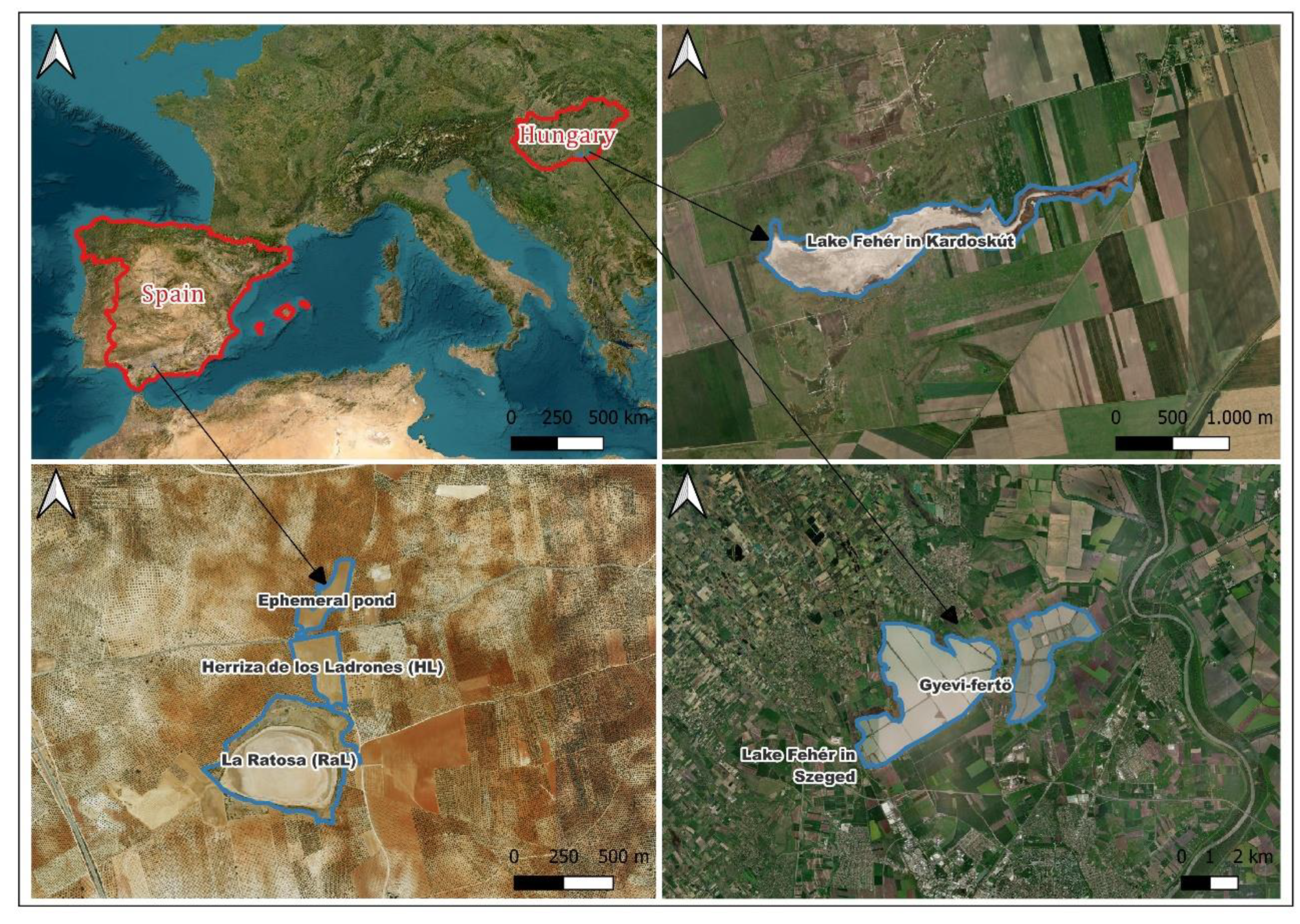
Figure 1.
Location of the study area. Red lines – country borders; Blue lines – playa-lake shorelines.
Figure 1.
Location of the study area. Red lines – country borders; Blue lines – playa-lake shorelines.
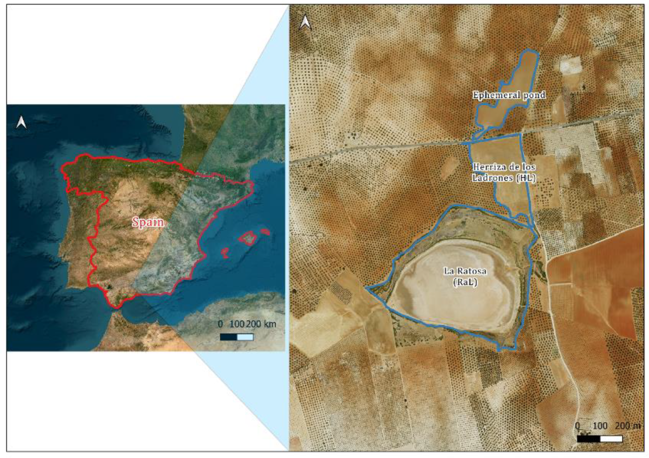
Figure 2.
Ratosa playa-lake system and La-Camorra aquifer. RaL stands for Ratosa playa-lake, HL stands for Herriza de los Ladrones playa-lake. Official, proposed [23] and natural borders are defined in the figure’s legend. Modified from [23].
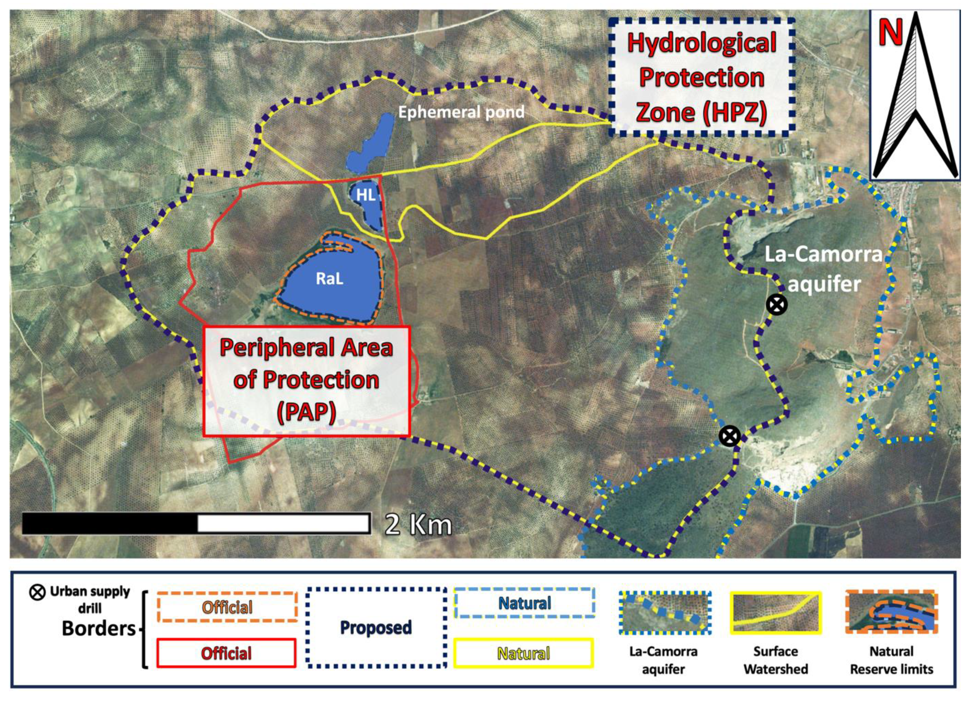
Figure 3.
(A) and (B) cross-section showing the playa-lakes bathymetry and morphology. (C) Ortopicture from 2010 (wet year) when HL and RaL are merged.
Figure 3.
(A) and (B) cross-section showing the playa-lakes bathymetry and morphology. (C) Ortopicture from 2010 (wet year) when HL and RaL are merged.
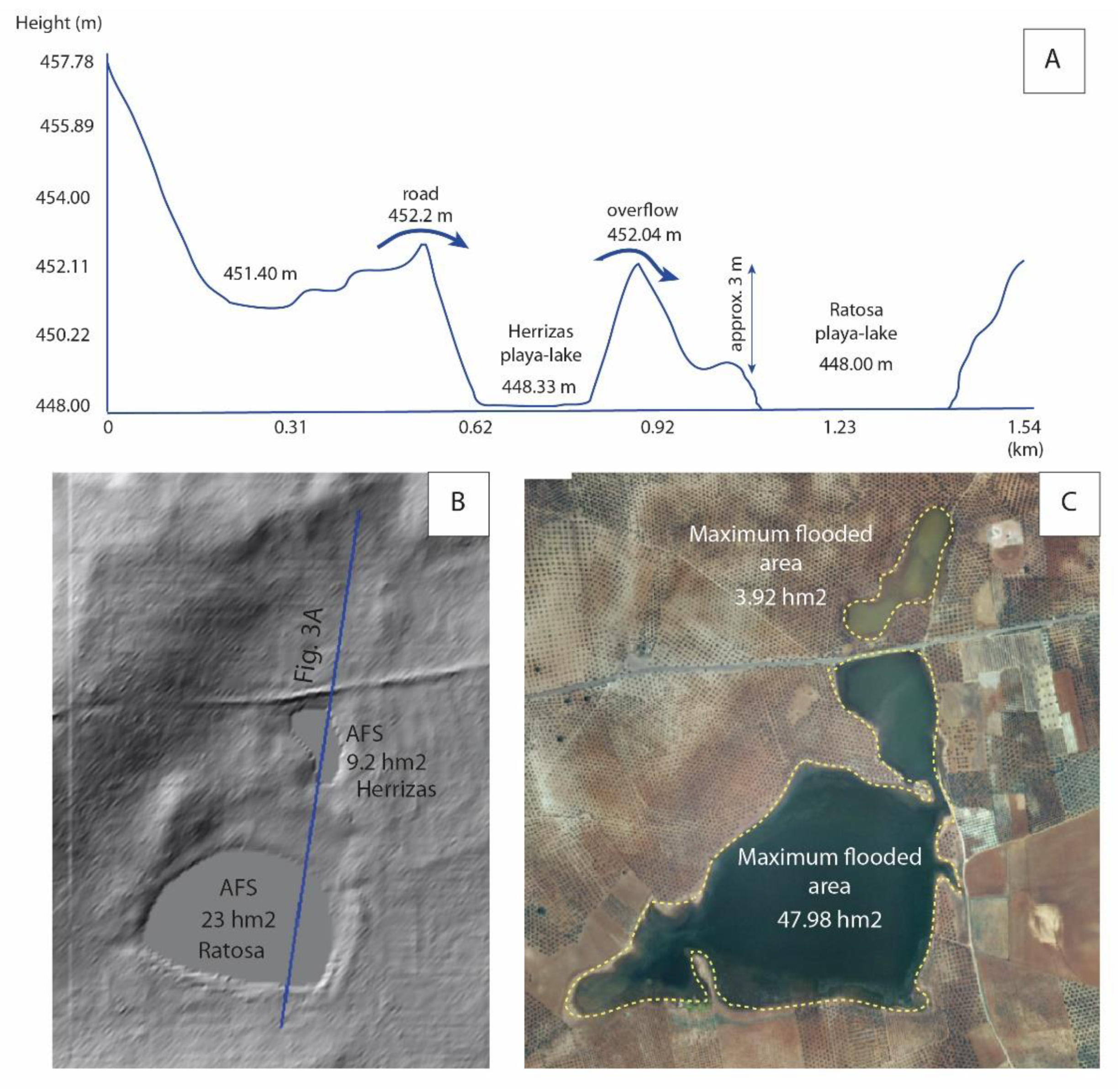
Figure 4.
(a) Geological map of RaL area, (b) stereoplot of main faults and (c) and (d) well data from Ratosa and Santaella wells (red dots).
Figure 4.
(a) Geological map of RaL area, (b) stereoplot of main faults and (c) and (d) well data from Ratosa and Santaella wells (red dots).
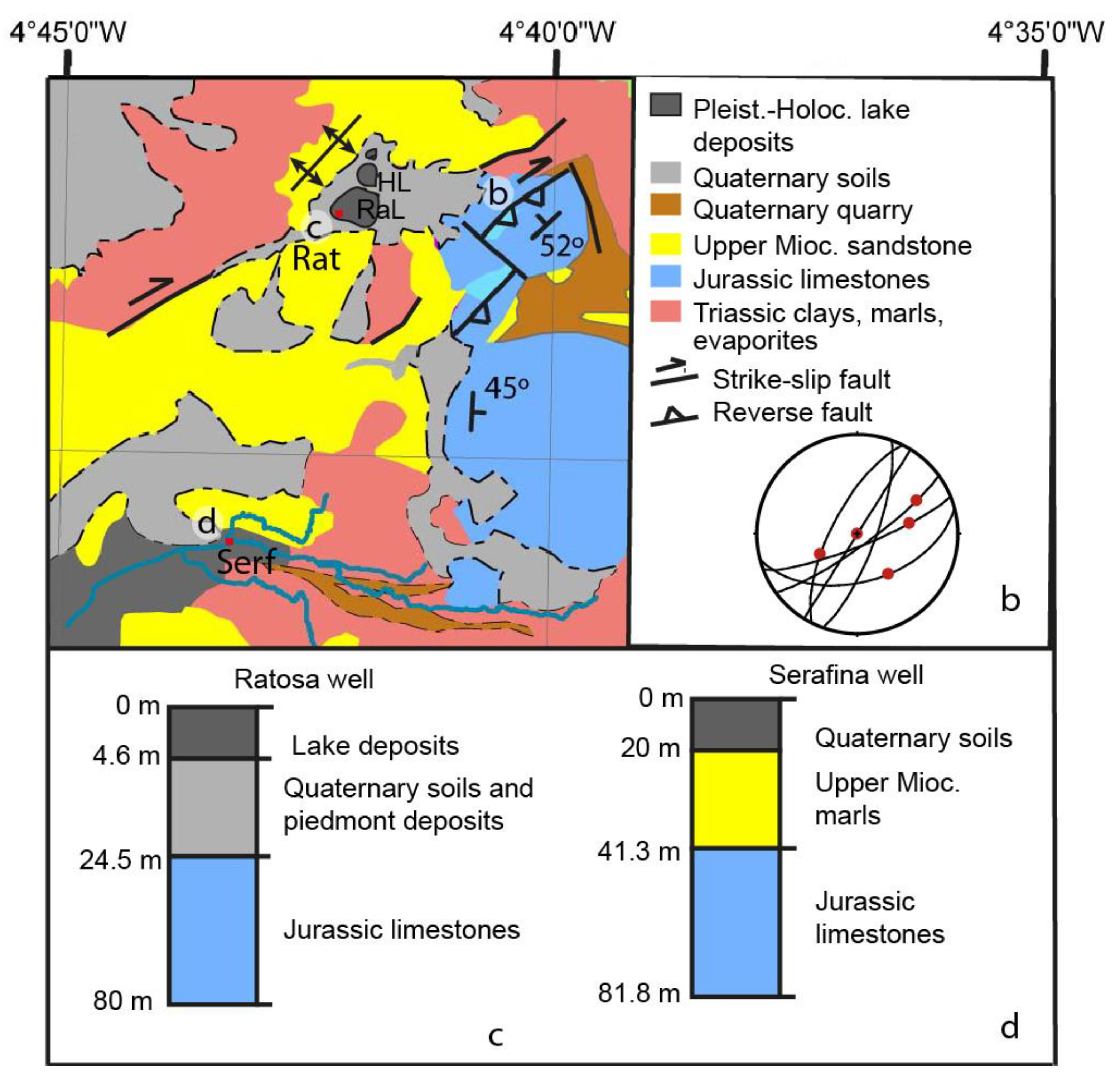
Figure 5.
(A) and (B) Hydrograms of RaL and HL during the studied period (2005-2025). C) A detail of a wet period (01/2010 to 03/2011) is shown. Yellow circle represents the moment of merging in RaL and HL, last time registered in year 2011. D) The most recent rainfall period (18/04/2023 to 31/01/2025) is shown, during which both RaL and HL remained completely dry.
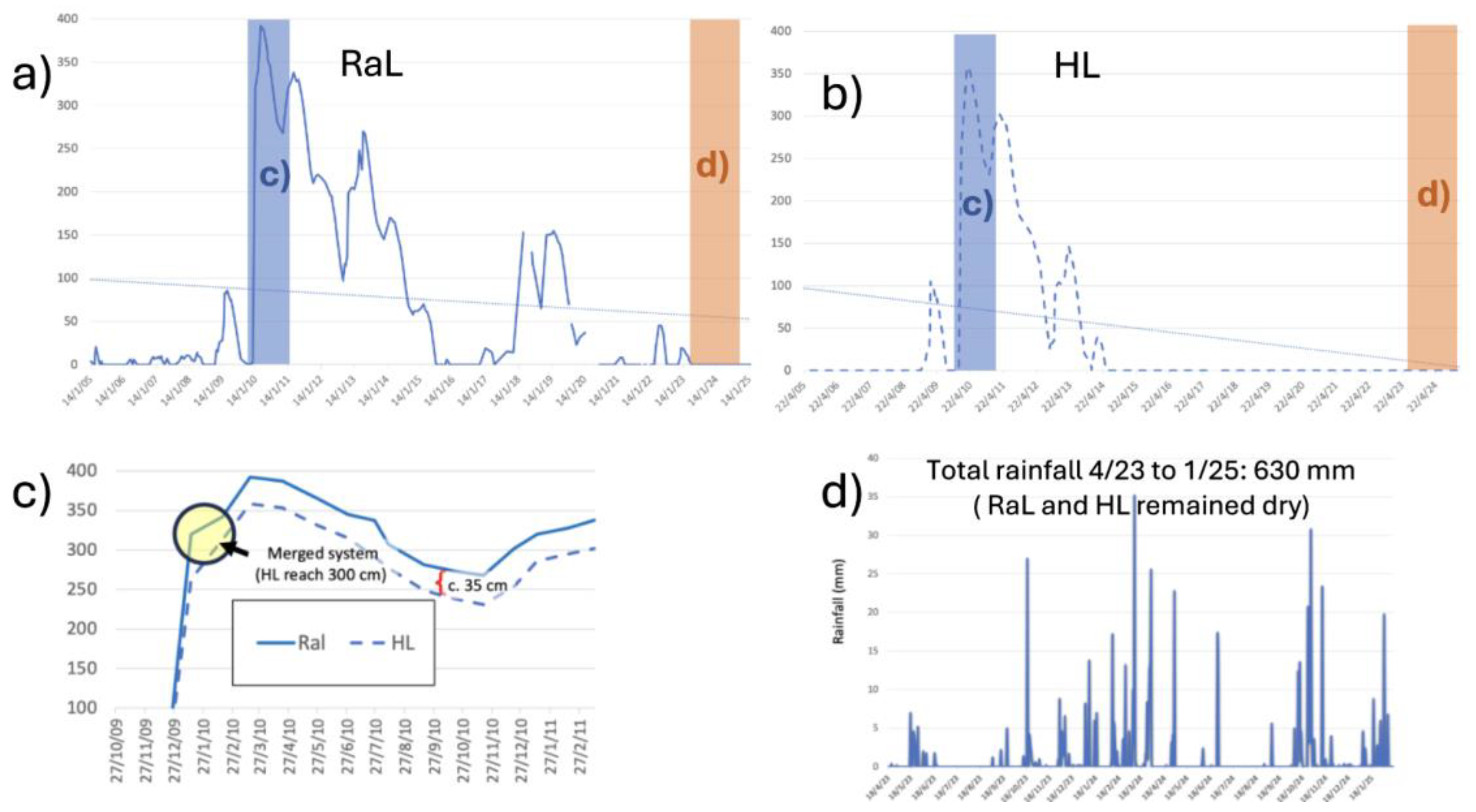
Figure 6.
Water level modelling of the RaL and HL playa-lakes. Red: Actual data. Blue: Modelled data. Yellow color shows the period when both playa-lakes merged.
Figure 6.
Water level modelling of the RaL and HL playa-lakes. Red: Actual data. Blue: Modelled data. Yellow color shows the period when both playa-lakes merged.
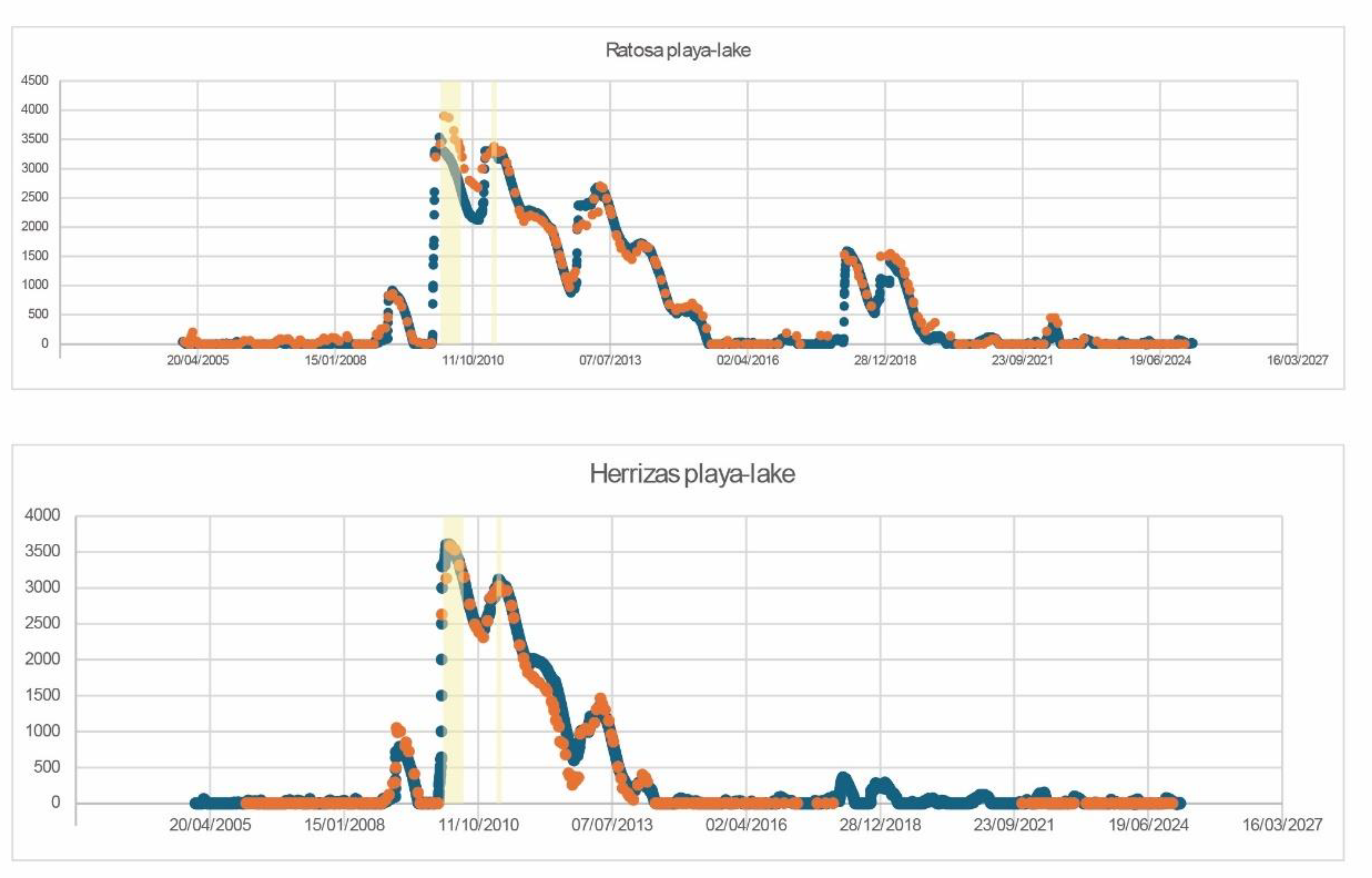
Figure 7.
Statistical analysis derived from the ordinary least squares.
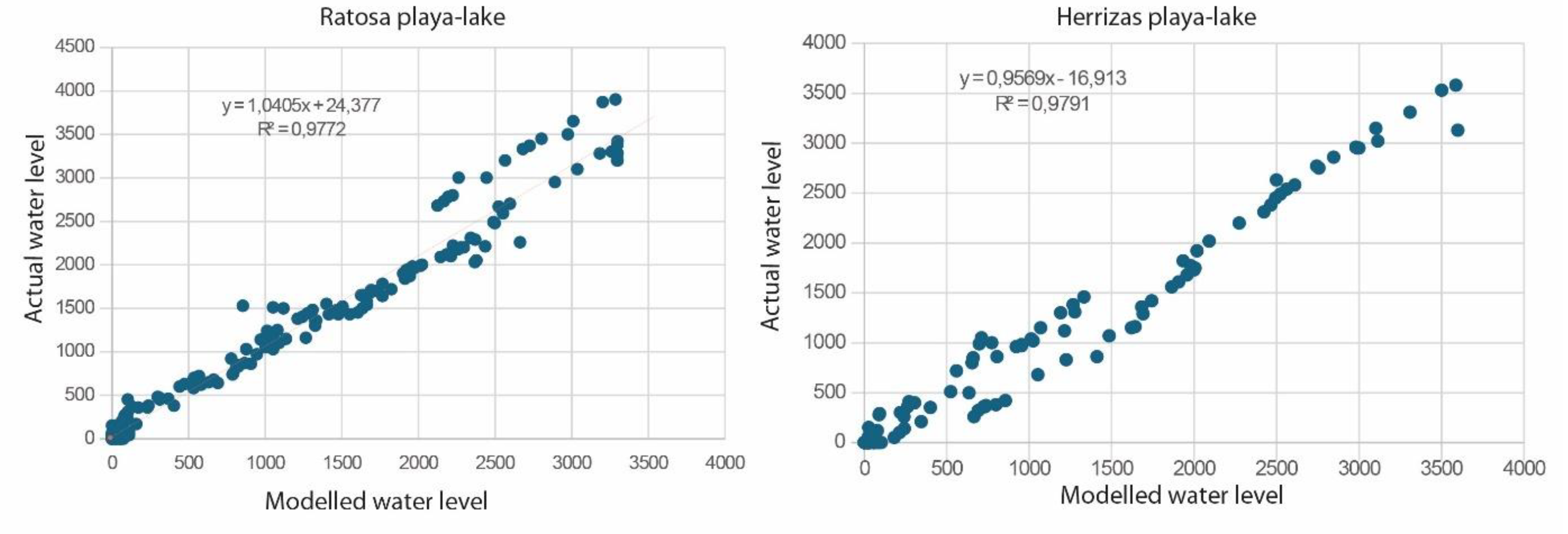
Figure 8.
Water level modelling of RaL and HL for the RCP 4.5 and RCP 8.5 climate change scenarios. a)RaL. Red: RCP 4.5. Blue: RCP 8.5, b) HL. Red: RCP 4.5. Blue: RCP 8.5.
Figure 8.
Water level modelling of RaL and HL for the RCP 4.5 and RCP 8.5 climate change scenarios. a)RaL. Red: RCP 4.5. Blue: RCP 8.5, b) HL. Red: RCP 4.5. Blue: RCP 8.5.
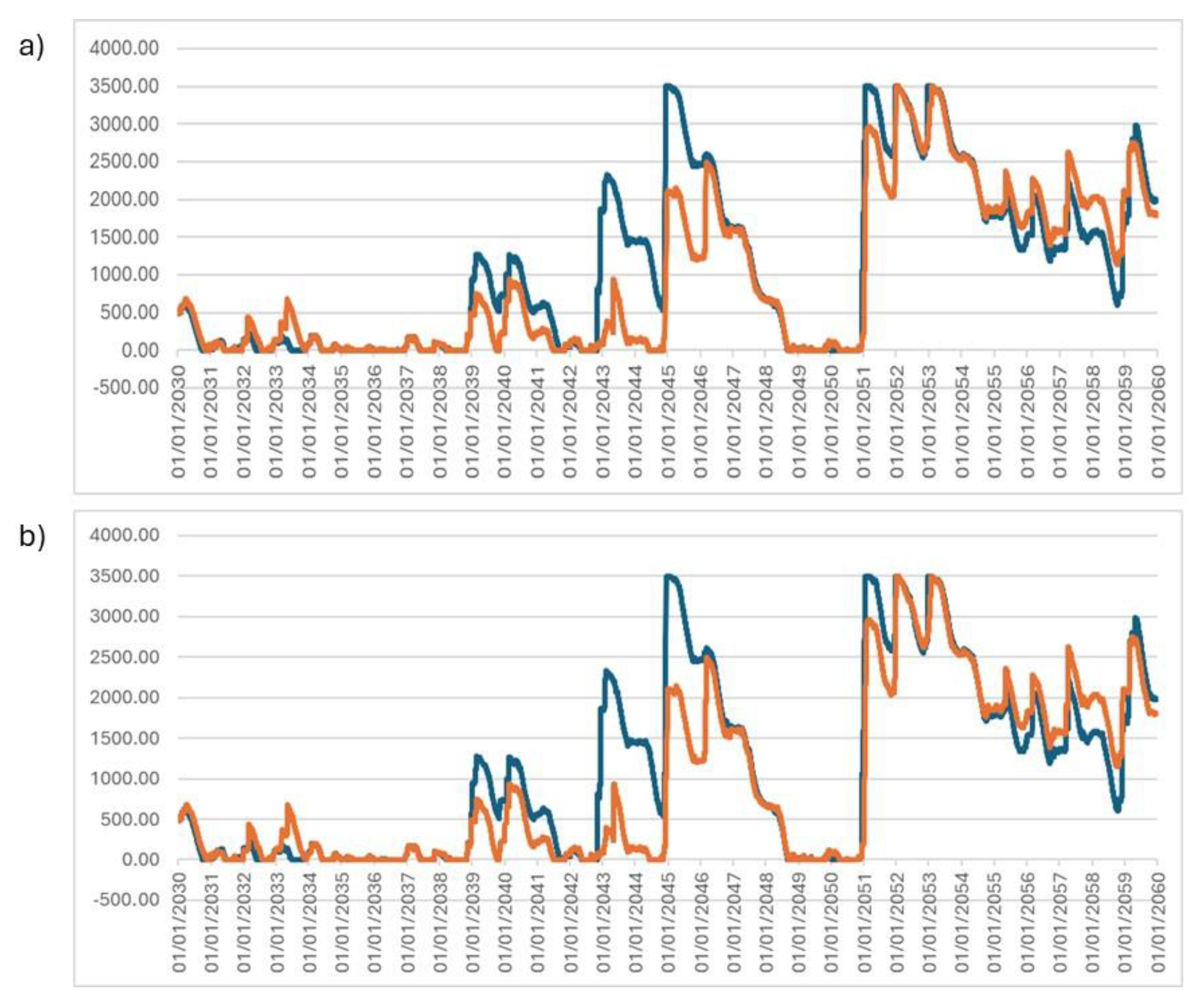
Figure 9.
Piezometric evolution in Santillan piezometer, located in Mollina-La Camorra aquifer, from 1993 to 2025 (dash line represents a data less interval). Piezometric level is expressed in m a.s.l. Also, the bottom of RaL is represented as a dotted black line.
Figure 9.
Piezometric evolution in Santillan piezometer, located in Mollina-La Camorra aquifer, from 1993 to 2025 (dash line represents a data less interval). Piezometric level is expressed in m a.s.l. Also, the bottom of RaL is represented as a dotted black line.
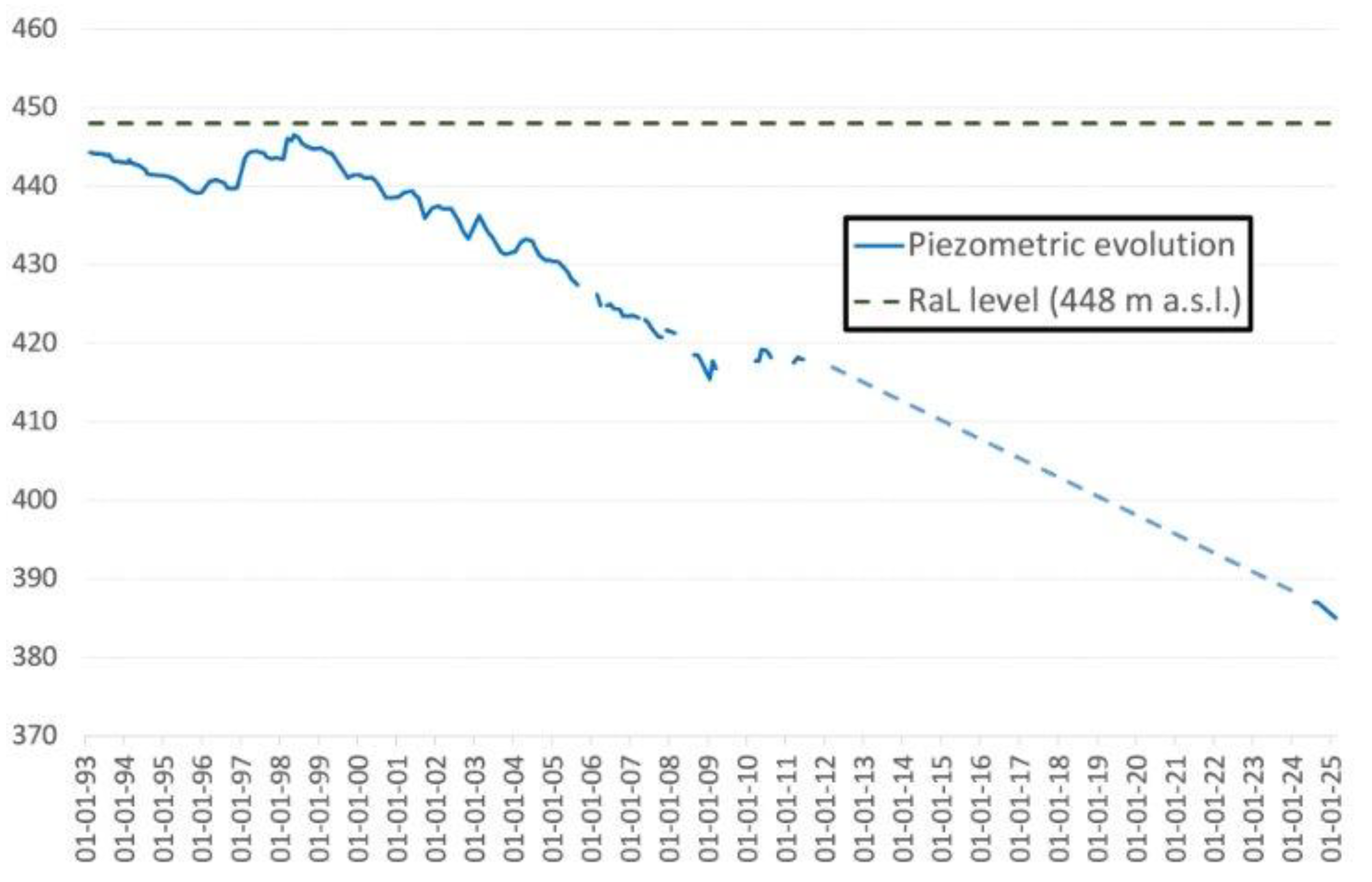
Figure 10.
Hydrogeological model of La-Camorra – RaL playa-lake and evolution of the hydrological regime in the latter. Stage a (natural regime) seasonal playa-lake, Stage b (2015, Alameda spring is dry, and a Hydrological Protection Zone is proposed) temporary playa-lake. Stage c, hypothetical situation of a recharge system (dropdown of piezometric levels) ephemeral playa-lake.
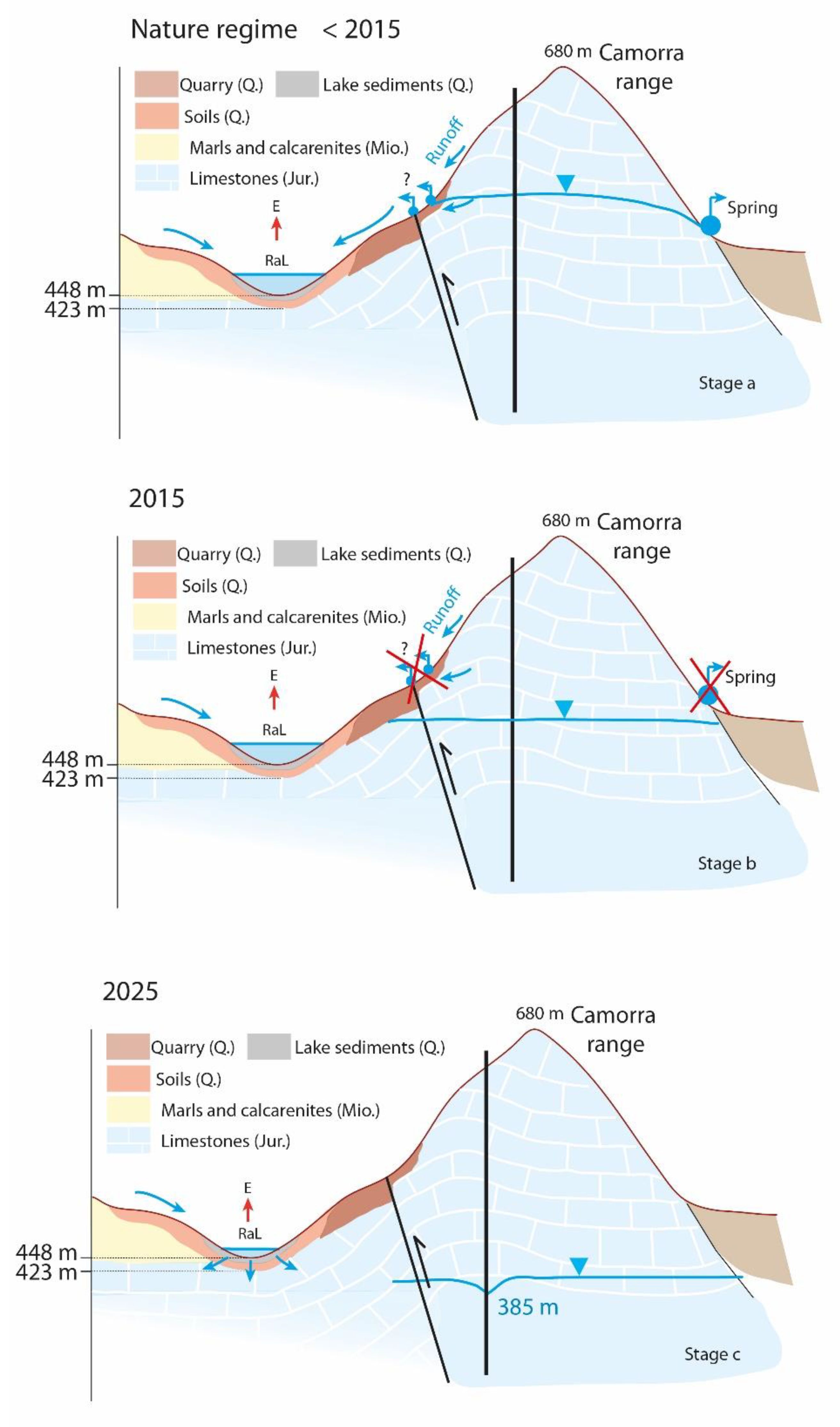
Figure 11.
Evolution of RaL from January 2023 to October 2024. In April 2023 RaL dried up and remained dry until date (February 2025). Campillos (CAM) playa-lakes and Archidona (ARC) lakes evolution during the same period is shown. Water level is expressed in cm; Grande-ARC level, in cm, is in the right axis. *Note that HL playa-lake has remained dry since 2015.
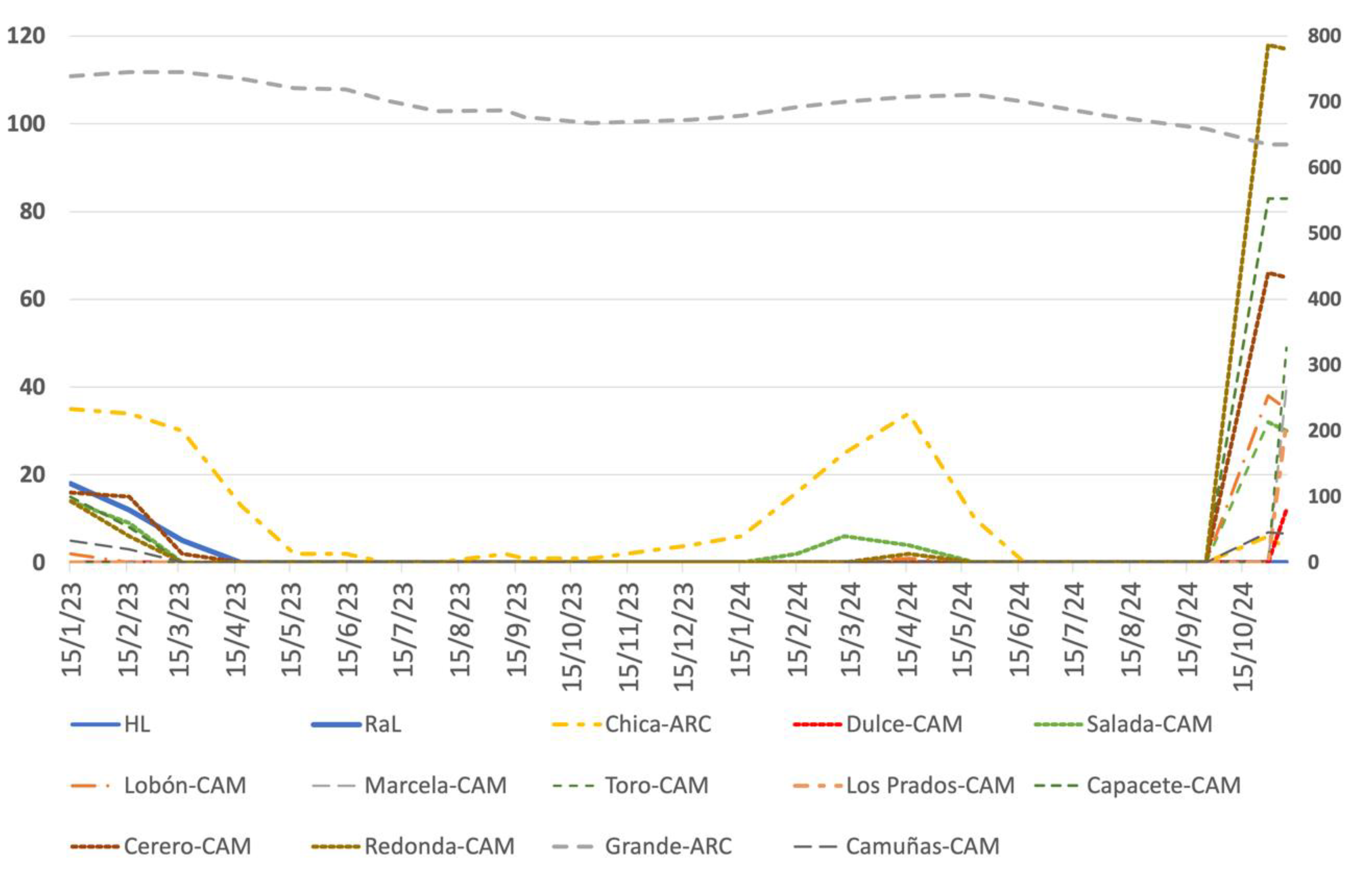
Figure 12.
Left: G. Google Earth view of La Camorra mountain range, RaL and HL. Right: Drone pictures taken in may 2021 showing the intense degration of HL, transformed into a wheat field. Yellow circles indicates positions in left and right pictures, respectively.
Figure 12.
Left: G. Google Earth view of La Camorra mountain range, RaL and HL. Right: Drone pictures taken in may 2021 showing the intense degration of HL, transformed into a wheat field. Yellow circles indicates positions in left and right pictures, respectively.
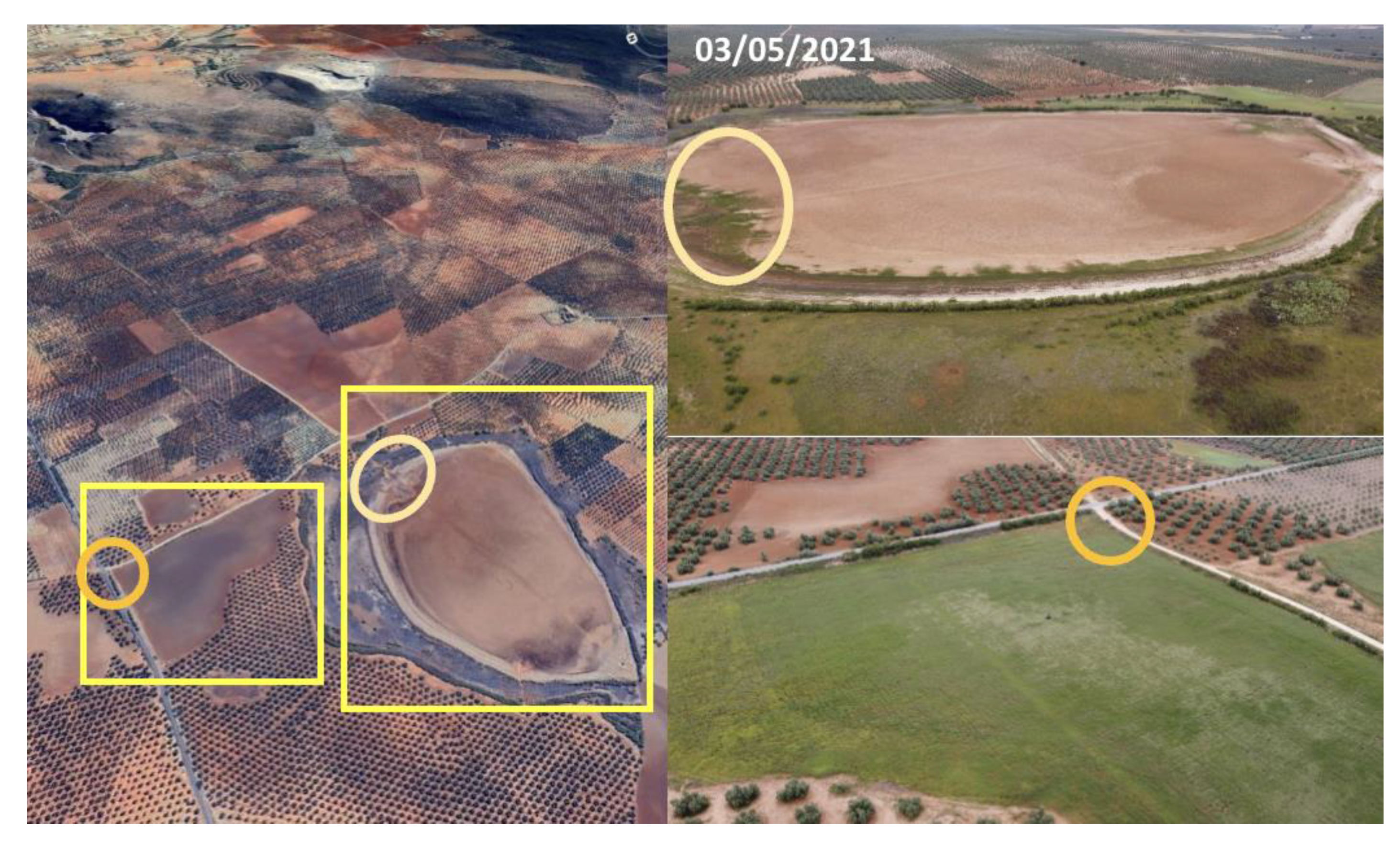

Table 1.
Watershed and flooded area used for modelling.
| Watershed (hm2) | Flooded area (hm2) | Relationship (W/flooded área) | ||
|---|---|---|---|---|
| RaL | 557 | 23 | 24 | average year |
| HL | 150 | 9,2 | 16 | average year |
| Ratosa system | 797 | 52 | 15 | wet year (water level > 3 m) |
Disclaimer/Publisher’s Note: The statements, opinions and data contained in all publications are solely those of the individual author(s) and contributor(s) and not of MDPI and/or the editor(s). MDPI and/or the editor(s) disclaim responsibility for any injury to people or property resulting from any ideas, methods, instructions or products referred to in the content. |
© 2025 by the authors. Licensee MDPI, Basel, Switzerland. This article is an open access article distributed under the terms and conditions of the Creative Commons Attribution (CC BY) license (http://creativecommons.org/licenses/by/4.0/).
Copyright: This open access article is published under a Creative Commons CC BY 4.0 license, which permit the free download, distribution, and reuse, provided that the author and preprint are cited in any reuse.


