

Submitted:
20 February 2025
Posted:
20 February 2025
You are already at the latest version
Abstract
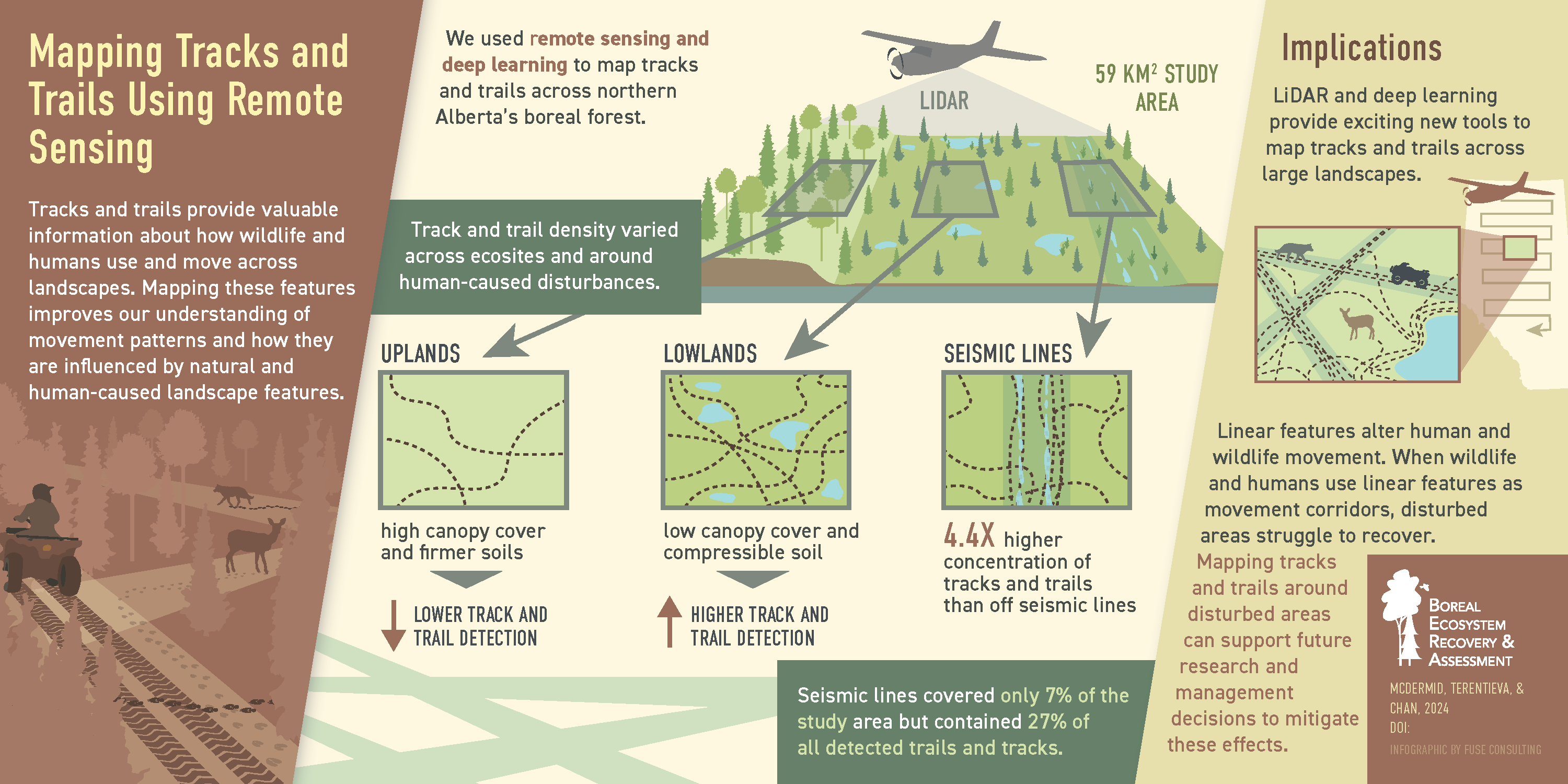
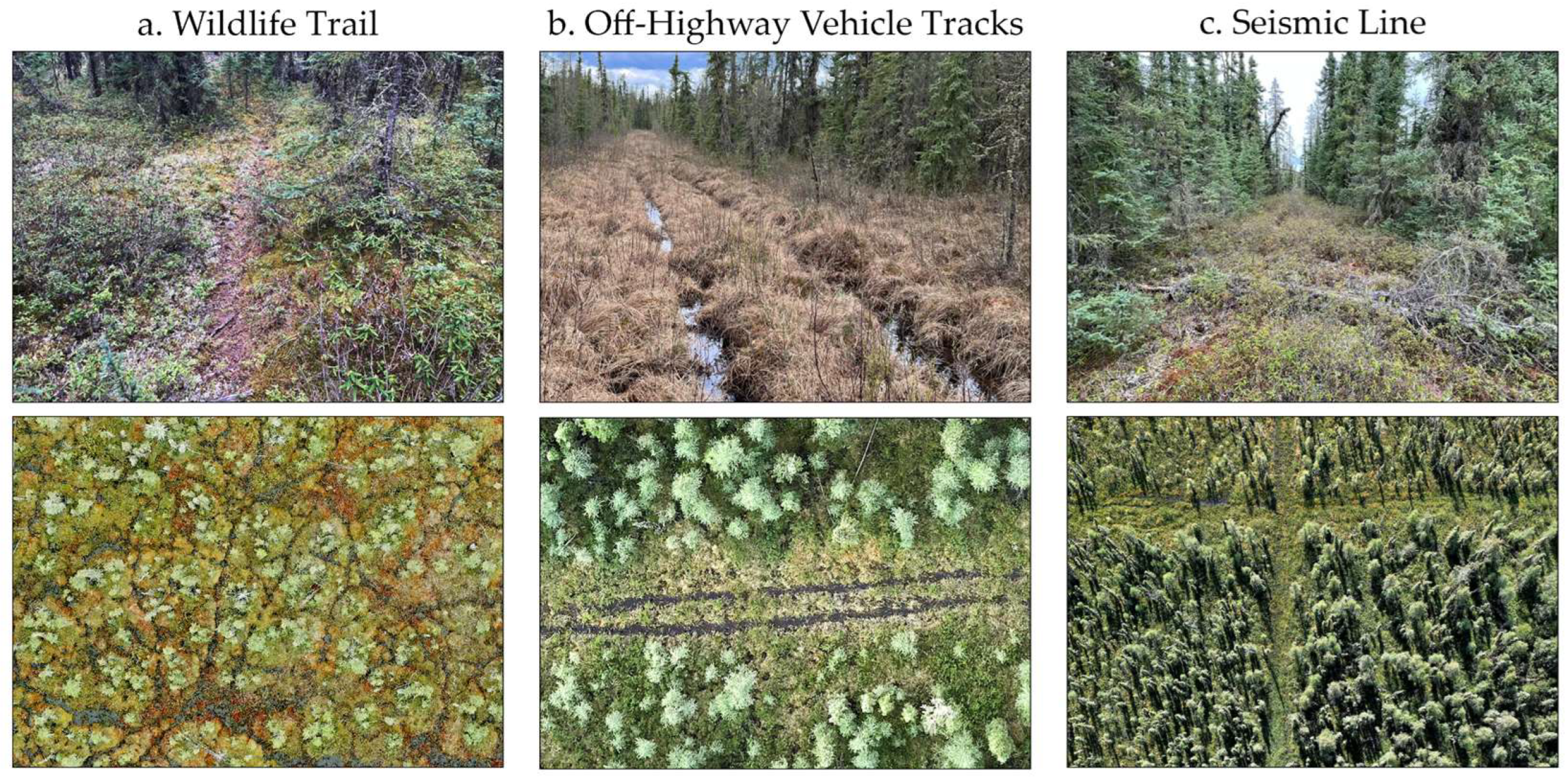
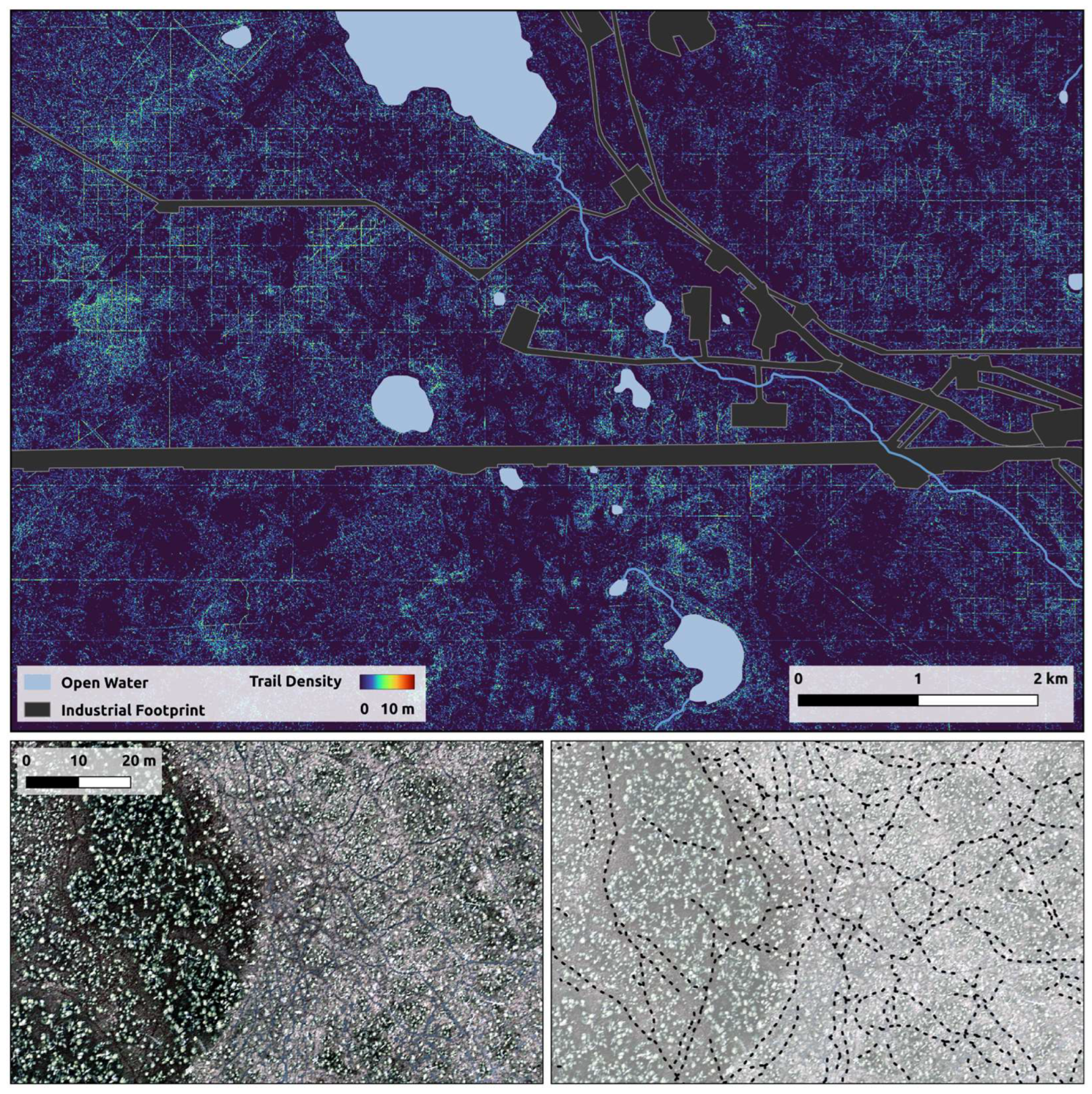
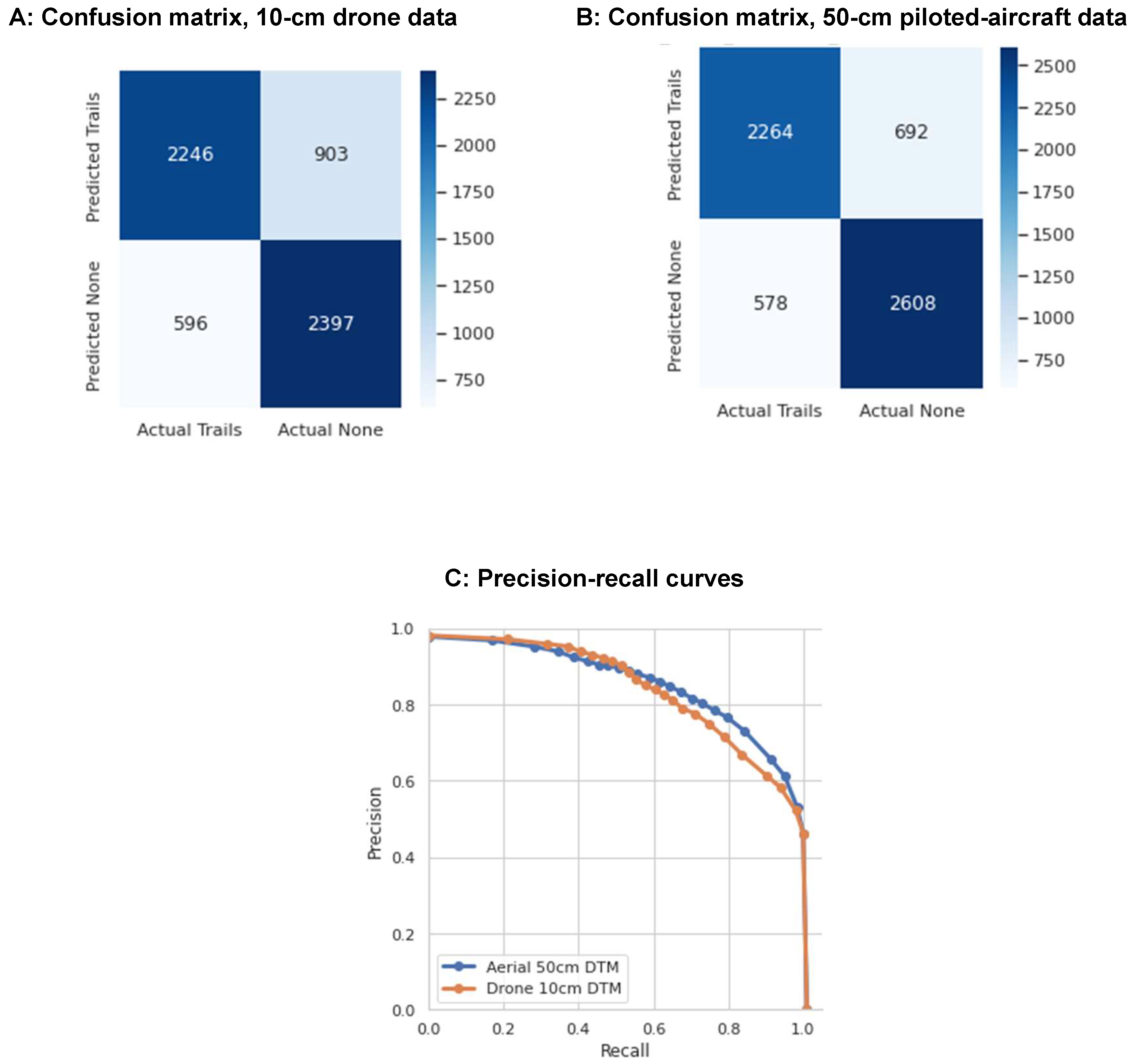
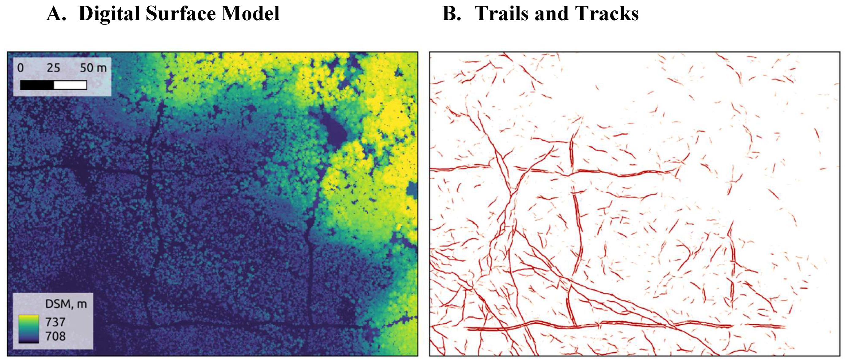
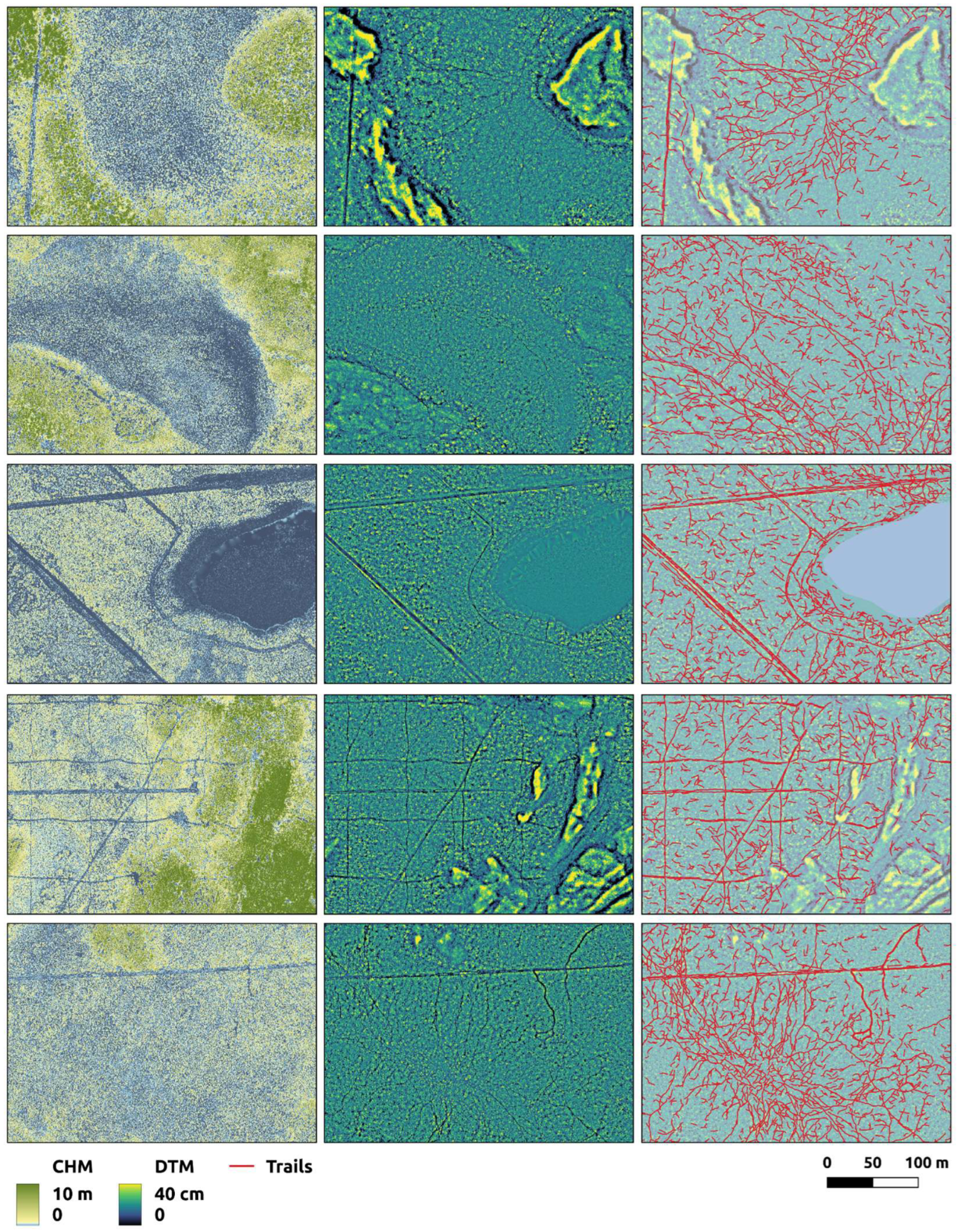
Trails and tracks are the detectable signs of passage of wildlife and off-highway vehicles in natural landscapes. They record valuable information on the presence and movement of animals and humans. However, published works aimed at mapping trails and tracks with remote sensing are nearly absent from the peer-reviewed literature. We demonstrate the capacity of high-density LiDAR and convolutional neural networks to map undifferentiated trails and tracks automatically across a diverse study area in the Canadian boreal forest. We compared maps developed with LiDAR from a drone platform (10-cm digital terrain model) with those from a piloted-aircraft platform (50-cm digital terrain model). We found no significant difference in the accuracy of the two maps. In fact, the piloted-aircraft map (F1 score of 77 ± 9%) performed nominally better than the drone map (F1 score of 74 ± 6%) and demonstrated better balance among error types. Our maps reveal a 2,829-km network of trails and tracks across the 59-km2 study area. These features are especially abundant in peatlands, where the density of detected trails and tracks was 68 km/km2. We found a particular tendency for wildlife and off-highway vehicles to adopt linear industrial disturbances like seismic lines into their movement networks. While linear disturbances covered just 7% of our study area, they contained 27% of all detected trails and tracks. This type of funneling effect alters the movement patterns of humans and wildlife across the landscape and impedes the recovery of disturbed areas. While our work is a case study, the methods developed have broader applicability, showcasing the potential to map trails and tracks across large areas using remote sensing and convolutional neural networks. This capability can benefit diverse research and management communities.
Keywords:
1. Introduction
1.1. Mapping Trails and Tracks
1.2. Research Objectives
- To demonstrate the capacity of high-density LiDAR and CNNs to map trails and tracks automatically in a natural environment;
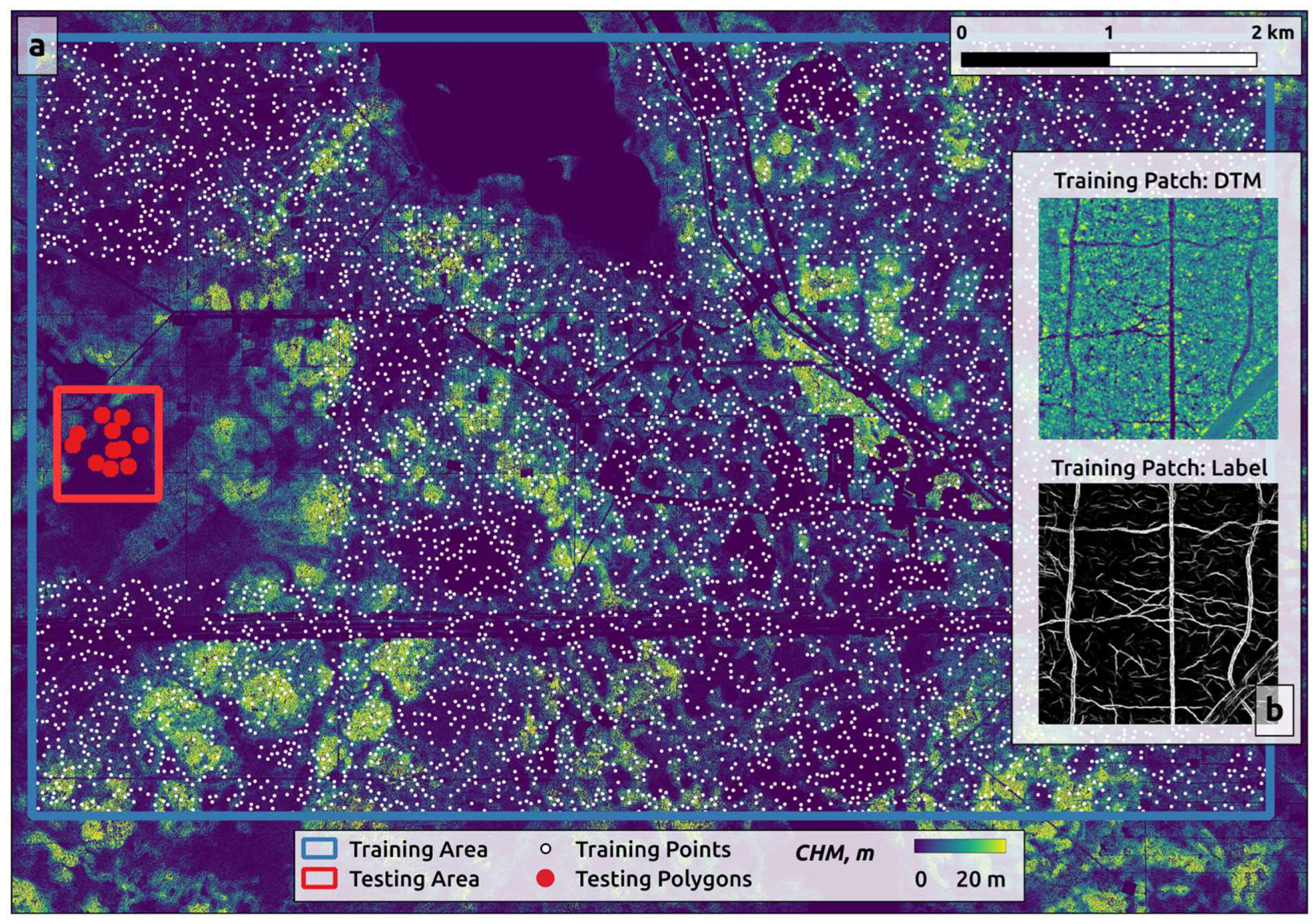
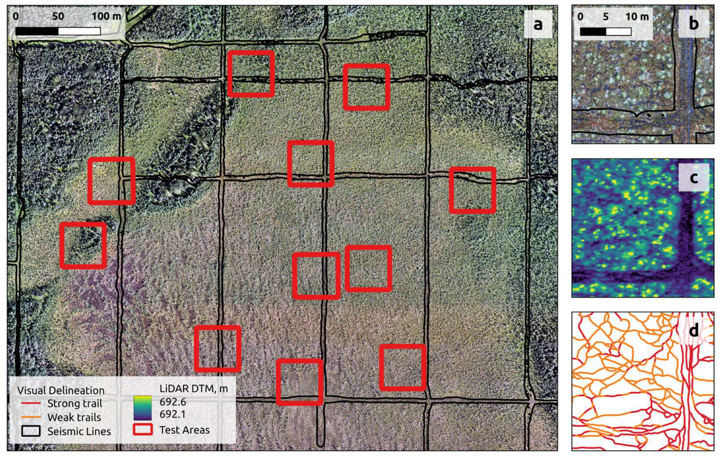
- To compare the accuracy of trail/track maps developed with LiDAR from a drone platform (185 points/m2) and a piloted aircraft platform (30 points/m2); and
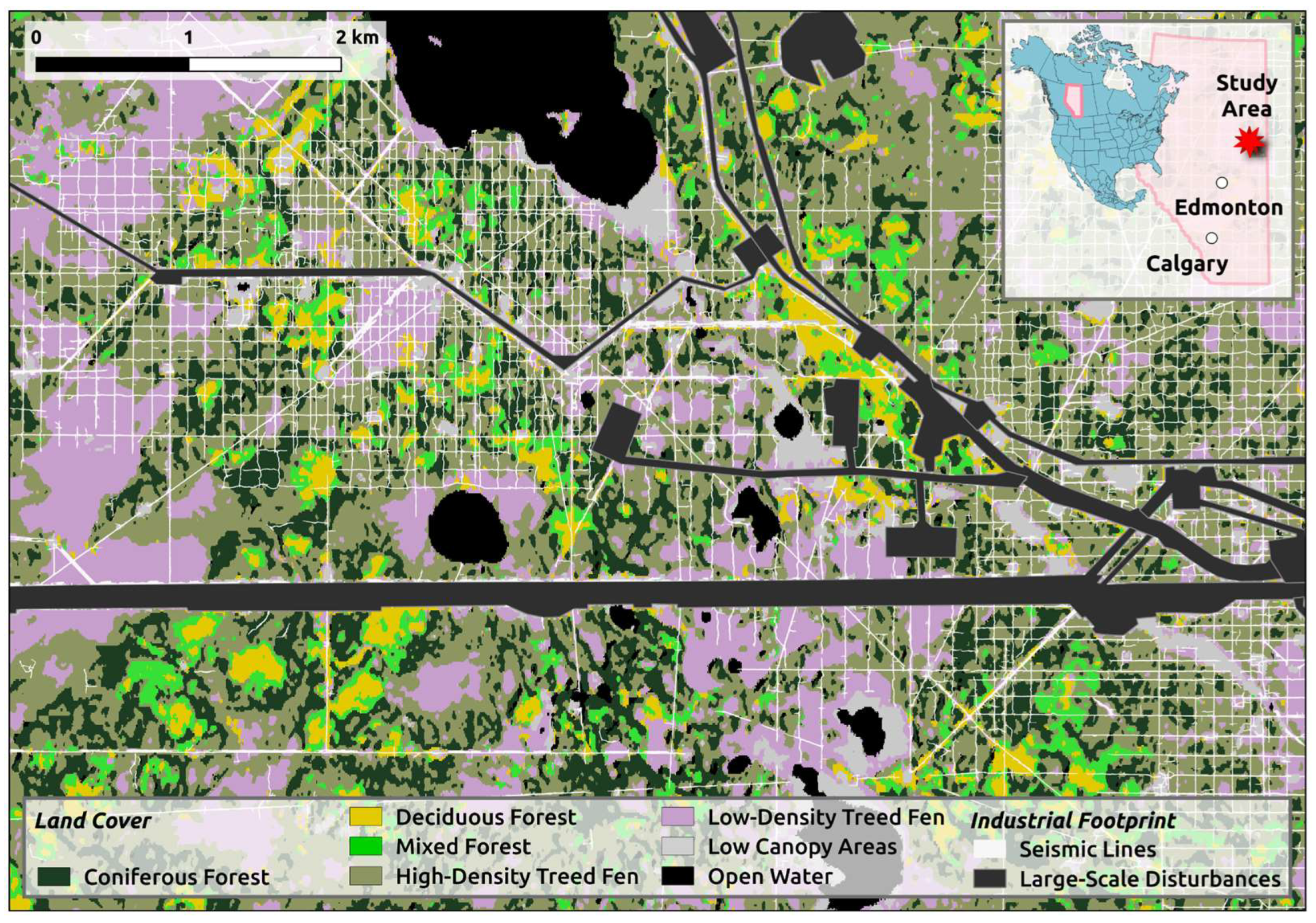
- To measure the abundance and distribution of tracks and trails across different land-cover classes, and their co-location with anthropogenic disturbances across our study area in the Canadian boreal forest.
2. Materials and Methods
2.1. Study Area
Data Acquisition and Processing
Mapping Trails and Tracks
2.3.1. Training Data Preparation
2.3.2. U-Net
2.3.3. Accuracy Assessment
Land Cover and Seismic Line Maps
3. Results
3.1. Mapping Trails and Tracks
3.2. Accuracy of Piloted Aircraft- and Drone-Based Models
3.3. Distribution of Trails and Tracks Across Land-Cover Classes
3.4. Seismic Line Influence on Trails and Tracks
4. Discussion
4.1. Boreal Trails and Tracks Can Be Mapped with LiDAR and Convolutional Neural Networks
4.2. Canopy Density and Substrate Materials Are Key Factors
4.3. Drone- and Piloted-Aircraft Map Accuracies Are Statistically Identical
4.3. Patterns of Trails and Tracks in Our Study Area
4.4. Ecosystem Effects of Trails and Tracks
4.5. Assumptions and Limitations
4.6. Future Research Needs
5. Conclusions
Author Contributions
Funding
Data Availability Statement
Acknowledgments
Conflicts of Interest
Abbreviations
| LiDAR | Light detection and ranging |
| GNSS | Global navigation satellite system |
| CNN | Convolutional neural netork |
| OHV | Off-highway vehicle |
| BERA | Boreal Ecosystem Recovery and Assessment |
| PPP | Precise point positioning |
| RTK | Real time kinematic |
| DTM | Digital terrain model |
| S1 | Sentinel 1 |
| S2 | Sentinel 2 |
| CHM | Canopy height model |
References
- Perna, A.; Latty, T. Animal transportation networks. Journal of the Royal Society Interface 2014, 11. [Google Scholar] [CrossRef] [PubMed]
- Myslajek, R.W.; Olkowska, E.; Wronka-Tomulewicz, M.; Nowak, S. Mammal use of wildlife crossing structures along a new motorway in an area recently recolonized by wolves. European Journal of Wildlife Research 2020, 66. [Google Scholar] [CrossRef]
- Newmark, W.D.; Rickart, E.A. High-use movement pathways and habitat selection by ungulates. Mammalian Biology 2012, 77, 293–298. [Google Scholar] [CrossRef]
- Squies, J.R.; Olson, L.E.; Roberts, E.K.; Ivan, J.S.; Hebblewhite, M. Winter recreation and Canada lynx: reducing conflict through niche partitioning. Ecosphere 2019, 10. [Google Scholar] [CrossRef]
- Hebblewhite, M.; Miguelle, D.G.; Murzin, A.A.; Aramilev, V.V.; Pikunov, D.G. Predicting potential habitat and population size for reintroduction of the Far Eastern leopards in the Russian Far East. Biological Conservation 2011, 144, 2403–2413. [Google Scholar] [CrossRef]
- Kondratenkov, I.A.; Oparin, M.L.; Oparina, O.S. Estimation of the Ecological Density of Some Species of Game according to Winter Route Censuses. Biology Bulletin 2023, 50, 2710–2718. [Google Scholar] [CrossRef]
- Whittington, J.; St Clair, C.C.; Mercer, G. Path tortuosity and the permeability of roads and trails to wolf movement. Ecology and Society 2004, 9. [Google Scholar] [CrossRef]
- Slovikosky, S.A.; Merrick, M.J.; Morandini, M.; Koprowski, J.L. Movement response of small mammals to burn severity reveals importance of microhabitat features. Journal of Mammalogy 2024, 105, 157–167. [Google Scholar] [CrossRef]
- Kays, R.; Crofoot, M.C.; Jetz, W.; Wikelski, M. Terrestrial animal tracking as an eye on life and planet. Science 2015, 348. [Google Scholar] [CrossRef]
- Muhly, T.B.; Semeniuk, C.; Massolo, A.; Hickman, L.; Musiani, M. Human Activity Helps Prey Win the Predator-Prey Space Race. Plos One 2011, 6. [Google Scholar] [CrossRef]
- Palm, E.C.; Landguth, E.L.; Holden, Z.A.; Day, C.C.; Lamb, C.T.; Frame, P.F.; Morehouse, A.T.; Mowat, G.; Proctor, M.F.; Sawaya, M.A.; et al. Corridor-based approach with spatial cross-validation reveals scale-dependent effects of geographic distance, human footprint and canopy cover on grizzly bear genetic connectivity. Molecular Ecology 2023, 32, 5211–5227. [Google Scholar] [CrossRef] [PubMed]
- Harmsen, B.J.; Foster, R.J.; Silver, S.; Ostro, L.; Doncaster, C.P. Differential Use of Trails by Forest Mammals and the Implications for Camera-Trap Studies: A Case Study from Belize. Biotropica 2010, 42, 126–133. [Google Scholar] [CrossRef]
- Rowcliffe, J.M.; Field, J.; Turvey, S.T.; Carbone, C. Estimating animal density using camera traps without the need for individual recognition. Journal of Applied Ecology 2008, 45, 1228–1236. [Google Scholar] [CrossRef]
- Cambi, M.; Certini, G.; Neri, F.; Marchi, E. The impact of heavy traffic on forest soils: A review. Forest Ecology and Management 2015, 338, 124–138. [Google Scholar] [CrossRef]
- Kormanek, M.; Dvorák, J.; Tylek, P.; Jankovsky, M.; Nuhlícek, O.; Mateusiak, L. Impact of MHT9002HV Tracked Harvester on Forest Soil after Logging in Steeply Sloping Terrain. Forests 2023, 14. [Google Scholar] [CrossRef]
- Battigelli, J.P.; Spence, J.R.; Langor, D.W.; Berch, S.M. Short-term impact of forest soil compaction and organic matter removal on soil mesofauna density and oribatid mite diversity. Canadian Journal of Forest Research 2004, 34, 1136–1149. [Google Scholar] [CrossRef]
- Croke, J.; Hairsine, P.; Fogarty, P. Soil recovery from track construction and harvesting changes in surface infiltration, erosion and delivery rates with time. Forest Ecology and Management 2001, 143, 3–12. [Google Scholar] [CrossRef]
- Robroek, B.J.M.; Smart, R.P.; Holden, J. Sensitivity of blanket peat vegetation and hydrochemistry to local disturbances. Science of the Total Environment 2010, 408, 5028–5034. [Google Scholar] [CrossRef]
- Ares, A.; Terry, T.A.; Miller, R.E.; Anderson, H.W.; Flaming, B.L. Ground-based forest harvesting effects on soil physical properties and Douglas-Fir growth. Soil Science Society of America Journal 2005, 69, 1822–1832. [Google Scholar] [CrossRef]
- Marra, E.; Cambi, M.; Fernandez-Lacruz, R.; Giannetti, F.; Marchi, E.; Nordfjell, T. Photogrammetric estimation of wheel rut dimensions and soil compaction after increasing numbers of forwarder passes. Scandinavian Journal of Forest Research 2018, 33, 613–620. [Google Scholar] [CrossRef]
- Davidson, S.J.; Goud, E.M.; Franklin, C.; Nielsen, S.E.; Strack, M. Seismic Line Disturbance Alters Soil Physical and Chemical Properties Across Boreal Forest and Peatland Soils. Frontiers in Earth Science 2020, 8. [Google Scholar] [CrossRef]
- Dabros, A.; Higgins, K.L.; Pinzon, J. Seismic line edge effects on plants, lichens and their environmental conditions in boreal peatlands of Northwest Alberta (Canada). Restoration Ecology 2022, 30. [Google Scholar] [CrossRef]
- Lovitt, J.; Rahman, M.M.; McDermid, G.J. Assessing the Value of UAV Photogrammetry for Characterizing Terrain in Complex Peatlands. Remote Sensing 2017, 9. [Google Scholar] [CrossRef]
- Filicetti, A.T.; Nielsen, S.E. Effects of wildfire and soil compaction on recovery of narrow linear disturbances in upland mesic boreal forests. Forest Ecology and Management 2022, 510. [Google Scholar] [CrossRef]
- Wimpey, J.F.; Marion, J.L. The influence of use, environmental and managerial factors on the width of recreational trails. Journal of Environmental Management 2010, 91, 2028–2037. [Google Scholar] [CrossRef]
- Costantino, C.; Mantini, N.; Benedetti, A.C.; Bartolomei, C.; Predari, G. Digital and Territorial Trails System for Developing Sustainable Tourism and Enhancing Cultural Heritage in Rural Areas: The Case of San Giovanni Lipioni, Italy. Sustainability 2022, 14. [Google Scholar] [CrossRef]
- Norman, P.; Pickering, C.M. Using volunteered geographic information to assess park visitation: Comparing three on-line platforms. Applied Geography 2017, 89, 163–172. [Google Scholar] [CrossRef]
- Loosen, A.; Capdevila, T.V.; Pigeon, K.; Wright, P.; Jacob, A.L. Understanding the role of traditional and user-created recreation data in the cumulative footprint of recreation. Journal of Outdoor Recreation and Tourism-Research Planning and Management 2023, 44. [Google Scholar] [CrossRef]
- Abdollahi, A.; Pradhan, B.; Shukla, N.; Chakraborty, S.; Alamri, A. Deep Learning Approaches Applied to Remote Sensing Datasets for Road Extraction: A State-Of-The-Art Review. Remote Sensing 2020, 12. [Google Scholar] [CrossRef]
- Washington-Allen, R.A.; Van Niel, T.G.; Ramsey, D.; West, N.E. Remote Sensing-Based Piosphere Analysis. GIScience & Remote Sensing 2004, 41, 136–154. [Google Scholar] [CrossRef]
- Dara, A.; Baumann, M.; Freitag, M.; Hölzel, N.; Hostert, P.; Kamp, J.; Müller, D.; Prishchepov, A.V.; Kuemmerle, T. Annual Landsat time series reveal post-Soviet changes in grazing pressure. Remote Sensing of Environment 2020, 239. [Google Scholar] [CrossRef]
- Chang, C.C.; Wang, J.; Zhao, Y.B.; Cai, T.Y.; Yang, J.L.; Zhang, G.L.; Wu, X.C.; Otgonbayar, M.; Xiao, X.M.; Xin, X.P.; et al. A 10-m annual grazing intensity dataset in 2015-2021 for the largest temperate meadow steppe in China. Scientific Data 2024, 11. [Google Scholar] [CrossRef] [PubMed]
- Welch, R.; Madden, M.; Doren, R.F. Mapping the Everglades. Photogrammetric Engineering and Remote Sensing 1999, 65, 163–170. [Google Scholar]
- Kaiser, J.V.; Stow, D.A.; Cao, L. Evaluation of remote sensing techniques for mapping transborder trails. Photogrammetric Engineering and Remote Sensing 2004, 70, 1441–1447. [Google Scholar] [CrossRef]
- Yamato, C.; Ichikawa, K.; Arai, N.; Tanaka, K.; Nishiyama, T.; Kittiwattanawong, K. Deep neural networks based automated extraction of dugong feeding trails from UAV images in the intertidal seagrass beds. Plos One 2021, 16. [Google Scholar] [CrossRef]
- Bhatnagar, S.; Puliti, S.; Talbot, B.; Heppelmann, J.B.; Breidenbach, J.; Astrup, R. Mapping wheel-ruts from timber harvesting operations using deep learning techniques in drone imagery. Forestry 2022, 95, 698–710. [Google Scholar] [CrossRef]
- Marra, E.; Wictorsson, R.; Bohlin, J.; Marchi, E.; Nordfjell, T. Remote measuring of the depth of wheel ruts in forest terrain using a drone. International Journal of Forest Engineering 2021, 32, 224–234. [Google Scholar] [CrossRef]
- Flyckt, J.; Andersson, F.; Lavesson, N.; Nilsson, L.; Gren, A. Detecting ditches using supervised learning on high-resolution digital elevation models. Expert Systems with Applications 2022, 201. [Google Scholar] [CrossRef]
- Lidberg, W.; Paul, S.S.; Westphal, F.; Richter, K.F.; Lavesson, N.; Melniks, R.; Ivanovs, J.; Ciesielski, M.; Leinonen, A.; Agren, A.M. Mapping Drainage Ditches in Forested Landscapes Using Deep Learning and Aerial Laser Scanning. Journal of Irrigation and Drainage Engineering 2023, 149. [Google Scholar] [CrossRef]
- Du, L.; McCarty, G.W.; Li, X.; Zhang, X.; Rabenhorst, M.C.; Lang, M.W.; Zou, Z.H.; Zhang, X.S.; Hinson, A.L. Drainage ditch network extraction from lidar data using deep convolutional neural networks in a low relief landscape. Journal of Hydrology 2024, 628. [Google Scholar] [CrossRef]
- Natural Regions Committee, Natural Regions and Subregions of Alberta. Compiled by D.J. Downing and W.W. Pettapiece 2006, Pub. No. T/852 .
- Vitt, D.H. An overview of factors that influence the development of Canadian peatlands. Memoirs of the Entomological Society of Canada 1994, 7–20. [Google Scholar] [CrossRef]
- Dabros, A.; Pyper, M.; Castilla, G. Seismic lines in the boreal and arctic ecosystems of North America: environmental impacts, challenges, and opportunities. Environmental Reviews 2018. [Google Scholar] [CrossRef]
- Roussel, J.R.; Auty, D.; Coops, N.C.; Tompalski, P.; Goodbody, T.R.H.; Meador, A.S.; Bourdon, J.F.; de Boissieu, F.; Achim, A. lidR: An R package for analysis of Airborne Laser Scanning (ALS) data. Remote Sensing of Environment 2020, 251. [Google Scholar] [CrossRef]
- Roussel, J.R.; Auty, D. Airborne LiDAR Data Manipulation and Visualization for Forestry Applications. R package version 4.1.2 2024, https://cran.r-project.org/package=lidR.
- Ronneberger, O.; Fischer, P.; Brox, T. U-Net: Convolutional Networks for Biomedical Image Segmentation. arXiv 2015, arXiv:1505.04597. [Google Scholar]
- Oktay, O.; Schlemper, J.; Le Folgoc, L.; Lee, M.; Heinrich, M.; Misawa, K.; Mori, K.; McDonagh, S.; Hammerla, N.Y.; Kainz, B.; Glocker, B.; Rueckert, D. Attention U-Net: Learning Where to Look for the Pancreas. arXiv 2018, arXiv:1804.03999. [Google Scholar]
- Kingma, D.P.; Ba, J. Adam: A Method for Stochastic Optimization. arXiv 2014, arXiv:1412.6980. [Google Scholar]
- Zhang, T.Y.; Suen, C.Y. A Fast Parallel Algorithm for Thinning Digital Patterns. Commun. ACM 1984, 27, 236–239. [Google Scholar] [CrossRef]
- Queiroz, G.L.; McDermid, G.J.; Rahman, M.M.; Linke, J. The Forest Line Mapper: A Semi-Automated Tool for Mapping Linear Disturbances in Forests. Remote Sens. 2020, 12, 4176. [Google Scholar] [CrossRef]
- Price, J.S.; Cagampan, J.; Kellner, E. Assessment of peat compressibility: is there an easy way? Hydrological Processes 2005, 19, 3469–3475. [Google Scholar] [CrossRef]
- Crow, P.; Benham, S.; Devereux, B.J.; Amable, G.S. Woodland vegetation and its implications for archaeological survey using LiDAR. Forestry 2007, 80, 241–252. [Google Scholar] [CrossRef]
- Razak, K.A.; Straatsma, M.W.; van Westen, C.J.; Malet, J.P.; de Jong, S.M. Airborne laser scanning of forested landslides characterization: Terrain model quality and visualization. Geomorphology 2011, 126, 186–200. [Google Scholar] [CrossRef]
- Dietmaier, A.; McDermid, G.J.; Rahman, M.M.; Linke, J.; Ludwig, R. Comparison of LiDAR and Digital Aerial Photogrammetry for Characterizing Canopy Openings in the Boreal Forest of Northern Alberta. Remote Sensing 2019, 11. [Google Scholar] [CrossRef]
- Finnegan, L.; Hebblewhite, M.; Pigeon, K.E. Whose line is it anyway? Moose (<i>Alces alces</i>) response to linear features. Ecosphere 2023, 14. [Google Scholar] [CrossRef]
- Finnegan, L.; Pigeon, K.E.; Cranston, J.; Hebblewhite, M.; Musiani, M.; Neufeld, L.; Schmiegelow, F.; Duval, J.; Stenhouse, G.B. Natural regeneration on seismic lines influences movement behaviour of wolves and grizzly bears. Plos One 2018, 13. [Google Scholar] [CrossRef]
- Dickie, M.; Serrouya, R.; McNay, R.S.; Boutin, S. Faster and farther: wolf movement on linear features and implications for hunting behaviour. Journal of Applied Ecology 2017, 54, 253–263. [Google Scholar] [CrossRef]
- Dickie, M.; Sherman, G.G.; Sutherland, G.D.; McNay, R.S.; Cody, M. Evaluating the impact of caribou habitat restoration on predator and prey movement. Conservation Biology 2023, 37. [Google Scholar] [CrossRef]
- Lovitt, J.; McDermid, G.J.; Kariyeva, J.; Mahoney, C.; Hall, R.J.; Franklin, S.E.; Saxena, A.; Kalacska, M. UAV Remote Sensing Can Reveal the Effects of Low-Impact Seismic Lines on Surface Morphology, Hydrology, and Methane (CH₄) Release in a Boreal Peatland. Remote Sens. 2018, 10, 1549. [Google Scholar]
- Evans, M.; Warburton, J. Erosion in peatlands: Recent research progress and future directions. Earth-Sci. Rev. 2010, 103, 30–49. [Google Scholar]
- Williams-Mounsey, J.; Crowle, A.; Grayson, R.; Lindsay, R.; Holden, J. Surface structure on abandoned upland blanket peatland tracks. Journal of Environmental Management 2023, 325. [Google Scholar] [CrossRef]
- Pellerin, S.; Huot, J.; Côté, S.D. Long term effects of deer browsing and trampling on the vegetation of peatlands. Biological Conservation 2006, 128, 316–326. [Google Scholar] [CrossRef]
- Persson, I.L.; Danell, K.; Bergström, R. Disturbance by large herbivores in boreal forests with special reference to moose. Annales Zoologici Fennici 2000, 37, 251–263. [Google Scholar]
- Holmgren, M.; Groten, F.; Carracedo, M.R.; Vink, S.; Limpens, J. Rewilding Risks for Peatland Permafrost. Ecosystems 2023. [Google Scholar] [CrossRef]
- Ramirez, J.I.; Jansen, P.A.; Poorter, L. Effects of wild ungulates on the regeneration, structure and functioning of temperate forests: A semi-quantitative review. Forest Ecology and Management 2018, 424, 406–419. [Google Scholar] [CrossRef]
- Bengtsson, F.; Rydin, H.; Baltzer, J.L.; Bragazza, L.; Bu, Z.J.; Caporn, S.J.M.; Dorrepaal, E.; Flatberg, K.I.; Galanina, O.; Galka, M.; et al. Environmental drivers of<i>Sphagnum</i>growth in peatlands across the Holarctic region. Journal of Ecology 2021, 109, 417–431. [Google Scholar] [CrossRef]
- Nir, N.; Davidovich, U.; Ullman, M.; Schütt, B.; Stahlschmidt, M.C. The environmental footprint of Holocene societies: a multi-temporal study of trails in the Judean Desert, Israel. Frontiers in Earth Science 2023, 11. [Google Scholar] [CrossRef]
- Godtman Kling, K.; Fredman, P.; Wall-Reinius, S. Trails for tourism and outdoor recreation: A systematic literature review. Tourism: An International Interdisciplinary Journal 2017, 65, 488–508. [Google Scholar]

| Data Source | Precision (%) |
Recall (%) |
F1-score (%) |
Average Precision |
|---|---|---|---|---|
| Aerial 50 cm DTM | 77 ± 9 | 78 ± 14 | 77 ± 9 | 0.69 |
| Drone 10 cm DTM | 70 ± 10 | 80 ± 8 | 74 ± 6 | 0.64 |
| Trails and Tracks | |||
|---|---|---|---|
| Land-cover Type | Land-cover Area km2 (%) | Length km (%) |
Density (km/km2) |
| Coniferous forest | 10 (16.9) | 396 (14.0) | 40 |
| Deciduous forest | 3 (5.1) | 62 (2.2) | 21 |
| Mixed forest | 3 (5.1) | 51 (1.8) | 17 |
| High-density treed fen | 24 (40.7) | 1342 (47.4) | 56 |
| Low-density treed fen | 10 (16.9) | 978 (34.6) | 98 |
| Excluded areas (lakes, floodplains, roads, and dense industrial footprint) | 9 (15.2) | N/A | N/A |
| SUM | 59 (100) | 2829 (100) | |
| Area, km2 (%) |
Trails and Tracks Length km (%) |
Trails and Tracks Density km/km2 |
|
|---|---|---|---|
| On seismic lines | 4.2 (8) | 765 (27) | 182 |
| Off seismic lines | 45.7 (92) | 2,064 (73) | 41 |
| SUM | 49.9 (100) | 2,829 (100) |
Disclaimer/Publisher’s Note: The statements, opinions and data contained in all publications are solely those of the individual author(s) and contributor(s) and not of MDPI and/or the editor(s). MDPI and/or the editor(s) disclaim responsibility for any injury to people or property resulting from any ideas, methods, instructions or products referred to in the content. |
© 2025 by the authors. Licensee MDPI, Basel, Switzerland. This article is an open access article distributed under the terms and conditions of the Creative Commons Attribution (CC BY) license (http://creativecommons.org/licenses/by/4.0/).