Submitted:
03 December 2024
Posted:
04 December 2024
You are already at the latest version
Abstract
The central Ionian Sea is one of the most seismogenic areas in the Mediterranean Sea region. In particular, the island of Lefkada, Greece, has experienced many catastrophic earthquakes. The historical seismicity of Lefkada has been enriched and revised by utilizing published and little-known macroseismic information sources, e.g., administrative documents, letters, marginal notes, eyewitness accounts. We organized a new descriptive and parametric catalogue of 44 earthquakes having their maximum macroseismic intensity on Lefkada and covering the time interval from the 15th century AD up to 1911. Earthquake dates, origin times, intensity assignments, magnitudes and epicentral coordinates have been estimated or revised. Magnitudes in previous catalogues are overestimated with respect to our magnitude determinations which appear more re-alistic. The descriptive part of the catalogue includes descriptions of the earthquake impact on buildings but also of environmental effects, e.g., landslides and local tsunamis. The catalogue is likely complete for lower magnitude threshold Mw=6.0. One important yet puzzling earthquake is the one that reportedly damaged an unprecedentedly large region in Italy, Albania, Greece, including Lefkada, on 9/20 February 1743. Lit-tle-known documents revealed that the heavy destruction supposedly caused in Lefkada very likely was due to amalgamated information from local earthquakes and the large one.
Keywords:
historical earthquakes
; earthquake effects
; macroseismic intensity
; Greece
; Ionian Sea
; Lefkada island
; new historical catalogue
1. Introduction
The region of Ionian Sea (Greece) (Figure 1) is characterized by very high seismicity as reflected from the record of frequent high magnitude earthquakes, particularly in its central part, during the instrumental period of seismology. For example, the islands of Cephalonia, Ithaki, and Zakynthos were isolated by a devastating sequence of very strong earthquakes that ruptured the central Ionian Sea during August 1953. The three largest earthquakes occurred on 9, 11 and 12 August 1953 and measured moment magnitude, Mw, as high as 6.29, 6.53 and 6.81, respectively [1]. Significant damage was also noted in the island of Lefkada (or Lefkas or Leukas). This island, however, suffered a lot from strong (magnitude > 6.0) earthquakes occurring close to Lefkada in 1914, 1948 (two earthquakes), 2003, 2015 [2,3,4] (Figure 2). Because of its very high seismicity, the Ionian Sea attracts great interest among the international geoscientific community.
Dozens of strong earthquakes are also known to rupture the central Ionian Sea during the historical period particularly after the 15th century A.D. [e.g., [5,6,7,8,9,10,11,12,13,14,15,16,17,18,19,20,21,22,23,24]]. Investigation on the Ionian Sea historical seismicity is continual and new information gradually reveals [e.g., [25,26,27,28,29,30,31,32,33,34]]. On the other hand, parametric catalogues of historical earthquakes are revised from time to time under the light of new information and with the use of new techniques for the calculation of focal parameters [e.g., [12,13,14,15,16,17,19,21,22,23,24,35,36,37,38,39,40]].
In this paper we continue the effort for the revision of the historical seismicity in the Ionian Sea [21,33,40,41] by focusing on the earthquakes that hit the area of Lefkada Isl. from the 15th century A.D. up to 1911. To this aim we combined new historical material collected from little-known sources along with published information, re-evaluated the historical seismicity of the island and assigned revised macroseismic intensities. We also calculated earthquake magnitudes based on new local and regional empirical magnitude/intensity relationships. Following this procedure, a revised historical descriptive and parametric earthquake catalogue was compiled for the area of Lefkada Isl. Such a catalogue is useful to better understanding the seismotectonics and to the assessment of the seismic hazard in the region.
Figure 1.
Elements of the Hellenic Subduction Zone and the study area (inset, see Figure 2) (modified from [33]). Arrows illustrate lithospheric plate motions; the African (Nubian) lithospheric plate subducts from the Mediterranean Sea underneath the Aegean Sea at the southern Eurasian plate margin along the Hellenic Trench system; PTT, PLT and ST stand for Ptolemy, Pliny, and Strabo trenches, respectively; CTFZ=Cephalonia Transform Fault Zone. Key for islands: LE=Lefkada, IT=Ithaki, CE=Cephalonia, ZA=Zakynthos.
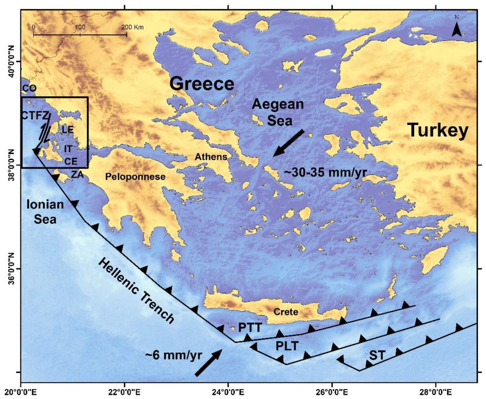
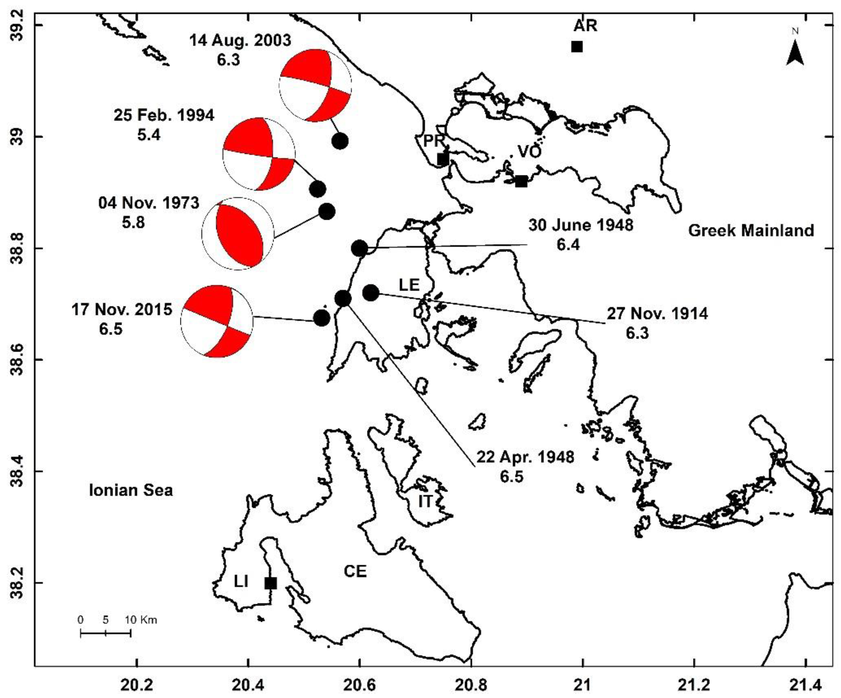
Figure 2.
Epicenters (solid circles), dates and magnitudes of strong instrumental earthquakes that occurred in the area of Lefkada Isl. Beach-balls illustrate fault-lane solutions. Key for localities: AR=Arta, CE=Cephalonia Isl., IT=Ithaki Isl., LE=Lefkada Isl., LI=Lixouri, PR=Preveza, VO=Vonitsa.
Figure 2.
Epicenters (solid circles), dates and magnitudes of strong instrumental earthquakes that occurred in the area of Lefkada Isl. Beach-balls illustrate fault-lane solutions. Key for localities: AR=Arta, CE=Cephalonia Isl., IT=Ithaki Isl., LE=Lefkada Isl., LI=Lixouri, PR=Preveza, VO=Vonitsa.
2. Materials and Methods
2.1. Seismotectonic Setting
The region of central Ionian Sea is characterized by a complex plate boundary dominated by two main geodynamic processes. The first is the northward subduction of the oceanic Nubia (African) slab beneath Eurasia (Figure 1), while the second is the collision of the Adria continental fragment of Nubia with Eurasia (see short reviews in [42,43,44]). The subduction of the Nubia slab beneath Eurasia is associated with low-dip reverse faults, e.g., [45,46,47,48,49]. The continental collision of the Adria fragment of Nubia with Eurasia is tectonically expressed by the right-lateral shear or sub-vertical faults situated within the upper crust along the Cephalonia Transform Fault Zone (CTFZ) situated at the western part of Lefkada and Cephalonia islands [50,51,52,53] (Figure 1). The two geotectonic regimes are characterized by the relatively high GPS velocities of ~30 mm yr−1, with respect to Europe, which is stable close to the Hellenic Subduction Zone. On the other hand, lower velocities of ∼10 mm yr−1 or less have been found in the CTFZ area [54,55]. In both regimes, however, the seismicity is high with earthquake magnitudes up to ~7.0. The most recent large earthquakes ruptured to the west of Lefkada on 17 November 2015 with Mw6.4 [e.g, [3,56]] and to the south of Zakynthos Isl. on 25 October 2018 (Mw6.84) [e.g., [43,44,57,58,59]]. The first earthquake was associated with right-lateral strike-slip faulting, which is typical for the CTFZ area, while the second was associated with oblique-thrust faulting. Tectonic field observations indicated that the most important active fault on the island of Lefkada is the Athani fault, which runs parallel to and near the west coast and is characterized by marked similarity with the northern branch of the offshore CTFZ [60].
2.2. Geography of Lefkada
For better understanding the historical seismicity of Lefkada it is of interest to remind some basic elements about the geography of the island. The island of Lefkada is elongated in N-S direction with length of c.30 km and maximum width of c.14 km and is situated very close to the Greek mainland (Figure 2). This implies that some of the historical earthquakes that hit Lefkada possibly had their sources either on the mainland or in the channel between the island and the mainland. The today main town, named simply “Lefkada town”, is situated at the northeastern tip of the island but in Venetian documents it was referred to as “Amaxiki”. However, the first town was built within the fortress of Santa Maura (Ayia Mavra in Greek) on a small island offshore the town that later was named Amaxiki. This kind of information is useful for understanding documents referring to seismic damage caused either in Santa Maura or in Amaxiki.
2.3. Information Sources
The seismicity in the central Ionian Sea is characterized by the lack of information about earthquakes occurring before the 15th century. This constitutes a geophysical paradox [33] given that the seismicity of the region is very high. One possible explanation is that for historical reasons many earthquakes escaped reporting, an issue that calls for further examination. However, the documentation of earthquakes is reach from the 15th century onwards.
Original macroseismic information sources for historical earthquakes that occurred in Lefkada include local archives, letters, marginal notes and memories, eyewitness accounts, official state documents as well as press reports and poems. The publications by Sathas [61] and Stamatelos [62] are of particular importance for the documentation of historical earthquakes occurring in Lefkada during the 17th, 18th and 19th centuries. The first source [61] reproduces earthquake descriptions from the manuscript “Istoria dei terremoti seguiti nell Isola di Leukadia dal 1612 al 1825” (An earthquake history of the island of Lefkada from 1612 to 1825) organized by the family of a local priest named Nikolas Zampelios. The publication by Stamatelos [62] reproduces information from the same manuscript but also from other local archives stored in the state archives of Lefkada. The publication by [5] is a valuable source compiling information from local documents, press reports and eyewitness accounts referring primarily to earthquakes that hit the island of Zakynthos (Zante). However, it contains limited but useful information for the earthquakes in Lefkada too. Limited information is also provided by local litterateurs who experienced themselves particular earthquakes [63,64]. A useful source of information is the two-volume unpublished manuscript “Book of Earthquakes” for the years from 1893 to 1915 [65,66], which is stored at the National Observatory of Athens (NOA). This Book comprises macroseismic observations collected by local observers affiliated with NOA in several parts of Greece. The macroseismic collection in that Book was partly published in the “Annales of NOA” from 1898 onwards.
Systematic compilations of historical earthquakes occurring in Lefkada can be found in later publications by educated historians and engineers [9,10,11,18,20], while additional documentation has been offered by modern seismologists and historians [21,25,26,27,28,29,30,31,67]. There is also a series of catalogues either descriptive or parametric or both [7,12,13,14,17,18,19,20,22,23,24,34,35,36,37,38,39,68] containing information for historical earthquakes occurring in Greece or specifically in Lefkada. The most recent parametric catalogues containing systematic information for the Lefkada earthquakes are the ones by [22,36,37]. However, earthquake focal parameters listed in the catalogues by [36] are extensively relying on previous catalogues. Therefore, the catalogues by [22,37] are of particular interest to our study.
Most historical sources utilized in this paper used Julian calendar dates (Old Style, O.S.). For more recent earthquakes, however, Gregorian calendar dates (New Style, N.S.) are provided. The local day/night timing in the historical period examined was based on a 12-hour day/12-hour night system traditionally assuming that day starts with sunrise (~6am) and night with sunset (~6pm).
2.4. Method
2.4.1. Introductory Remarks
The objective of this study is to compile a new descriptive and parametric catalogue of historical earthquakes that occurred in the area of Lefkada Isl. up to the year 1911 when the systematic instrumental monitoring of the Greek seismicity initiated. From the examination of the macroseismic information sources mentioned before we collected descriptions of earthquakes that caused damage or have been perceptible in Lefkada during the historical period and compiled an initial earthquake list. Questionable and spurious events have also been identified. We estimated maximum macroseismic intensity, Im, for each earthquake and organized our final earthquake list consisting by earthquakes that had Im on the island of Lefkada. For these earthquakes we corrected dates and origin times, if needed, and converted Julian dates to Gregorian dates and day/night times to modern local times. We also estimated or adopted epicentral coordinates and determined magnitudes.
2.4.2. Conversion of Dates
Conversion of Julian calendar dates (O.S.) to Gregorian calendar dates (N.S.) has been made after cross-checking information from more than one sources, if available. The conversion was performed by applying the practical formula (N.S. year) = (O.S. year-325)/128 [69]. Day/night times have been converted to the corresponding modern local times by taking into account the 12-hour day/night system which was in use during the historical time interval under examination (see subsection 2.3).
2.4.3. Macroseismic Intensity Assignment
From the macroseismic effects described in the information sources we compiled an initial list of earthquakes which are known to have affected Lefkada from the historical times up to 1911. The final list comprises earthquakes with assigned maximum macroseismic intensity, Im, on the island of Lefkada. We assigned Im in the 12-degree European Macroseismic Scale (EMS-98) [70]. Maximum intensity, Im, has not been estimated as a unique intensity value, e.g., Im=VI, but as a range of two sequential intensity values of the form Im=Ii-Ii+1. This means that Im is equal to either i or i+1; where i=I…XI, e.g., Im=VI-VII; both i and i+1 have the same probability 0.5 to represent the real intensity. The final intensity adopted for each earthquake is the average of Ii and Ii+1. This selection has been preferred for the reason that frequently the macroseismic descriptions are not clear enough to allow the selection of a unique intensity value. Another reason for this selection is that in the main towns of Lefkada, i.e., in Ayia Mavra and Amaxiki, an ingenious antiseismic building construction was used in the historical period under examination [71,72], a feature that complicates intensity characterization. Besides, mixed structures, i.e., timber-framed and stone houses, are mentioned in descriptions of damaging earthquakes in Lefkada like the 1613 (or 1611) one [72]. In the post-event report of a civil engineer referring to the Lefkada destructive earthquake of 1783 it is underlined that the building damage in the town is more important, because of the special construction of the houses, as compared to damage caused in village houses [10].
2.4.4. Magnitude Determination
Several techniques have been applied for magnitude determination for historical Greek or European earthquakes including the area of Lefkada [22,37]. Such techniques have in common that the magnitude determination has been based on the attenuation of macroseismic intensity as a function of magnitude and epicentral distance for instrumental earthquakes. The application of those techniques is susceptible to several uncertainties since it requires data sets of accurate intensity assignments and the establishment of calibrated regional intensity attenuation models. Τhe physiography of Greece is highly complex characterized by a mainland with high mountain range in the middle and the existence of many peninsulas and islands in the surrounding (Figure 1). Such a geomorphological configuration creates large spatial gaps in the macroseismic field, thus contributing to the increase of uncertainties involved in the intensity attenuation models.
Magnitudes for several historical earthquakes of Lefkada have been already determined by other authors [22,37] with the application of techniques like the ones proposed by other authors [73,74,75]. An alternative is to use empirical relationships Mw/Im and Mw/Ai between magnitude, Mw, and two attributes of the macroseismic field, the maximum intensity, Im, and the surface of perceptibility area, Ai, of intensity i [e.g., [76]]. Such a technique was advanced by considering data sets separately for inland, coastal and offshore instrumental Greek earthquakes for the time interval 1911-2005 [77,78,79,80]. For inland earthquakes the epicentral distance, Δ, from the point of Im observation point exceeds 20 km from the closest seashore, for coastal earthquakes Δ is up to 20 km in either sides from the closest seashore, while for offshore earthquakes Δ exceeds 20 km from the closest seashore. The previous approach has successfully been applied for the determination of historical earthquake magnitudes in other seismogenic areas of Greece [e.g, [78,79,80]].
No sufficient macroseismic data have been collected to apply Mw/Ai empirical relationships to historical earthquakes of Lefkada, therefore Mw/Im empirical relationships have been applied. We utilized relationships for coastal and offshore earthquakes for the reasons that there is no evidence of historical inland earthquakes that caused maximum intensity on Lefkada. Besides, during the instrumental period of seismology the strong, damaging earthquakes in Lefkada, with magnitudes up to 6.5 had their epicenters very close to or on the island, e.g., 27 September 1914 (Mw=6.3), 22 April 1948 (Mw=6.5), 30 June 1948 (Mw=6.4), 4 November 1973 (Mw=5.8), 25 February 1994 (Mw=5.4), 14 August 2003 (Mw=6.3), 17 November 2015 (Mw=6.5) (Figure 2). Eventually, for each one of the historical earthquakes included in the final list compiled, two magnitudes have been calculated from the next empirical relationships developed by [78]:
M1 = 4.125 (± 0.256) + 0.250 (± 0.030) Imax, coastal earthquakes (1)
M2 = 4.553 (± 0.692) + 0.233 (± 0.089) Imax, offshore earthquakes (2)
A second independent approach was based on a local M3/Imax empirical relationship that we obtained for instrumental earthquakes that occurred in the time interval 1911-2015 and had their maximum intensity on the island of Lefkada. This relationship was developed utilizing data sets for 31 earthquakes with moment magnitude ranging from 4.7 to 6.5 and intensity ranging from III to X+ (Table S1). Magnitudes have been adopted from the earthquake catalogue of the University of Thessaloniki (https://seismo.auth.gr/wp-content/uploads/2023/03/seiscat.dat). Imax intensity values have been retrieved from the Bulletins of the Institute of Geodynamics, National Observatory of Athens, for earthquakes occurring from 1911 up to 1994. Intensities for the 14 August 2003 (Mw=6.3) and 17 November 2015 (Mw=6.5) earthquakes were adopted from [2,81], respectively. The final magnitude adopted for each one of the Lefkada historical earthquakes examined is the average of the three magnitudes M1, M2 and M3. The magnitudes obtained with our procedure have been compared with magnitudes obtained by other authors [22,37]. The new catalog was also tested as of its completeness.
3. Results
3.1. Magnitude Determination
The local M3/Im empirical relationship obtained from data sets for 31 instrumental earthquakes in Lefkada is expressed by formula (3) (Figure 3), which is similar with an earlier formula found with smaller number of earthquakes [81].
M3= 0.25 Imax + 3.80, r2=0.71 (3)
The proxy-Mw magnitude adopted for each one of the earthquakes examined is the average of the three magnitudes M1, M2 and M3 calculated from the formulas (1), (2) and (3), respectively.
3.2. New Catalogue
3.2.1. Organization of the Catalogue
The procedure described in section 2.4 concluded with the compilation of a new catalogue of 44 earthquakes occurring in the area of Lefkada Isl. from AD 1469 up to 1911. One event has been characterized as spurious and is not counted among the 44 earthquakes. Maximum intensity value has been possible to estimate for 38 out of 44 earthquakes. For the remaining six earthquakes we have not been able to estimate intensity due to lack of sufficient macroseismic data. The new catalogue provides a descriptive and a parametric part for each one of the 44 earthquakes. The descriptive part yields a summary of the macroseismic effects along with the relevant citations. The parametric part contains the focal parameters of the earthquake, i.e., date and origin time, epicentral coordinates and magnitude. We assume that all earthquakes are shallow. In addition, the parametric part of the catalogue contains the estimated maximum intensity in the EMS-98 scale and the place this intensity was observed. For a few earthquakes one or more of the focal parameters are missing due to the lack of sufficient data. A synoptic parametric earthquake catalogue can be found in Table S2.
In the original information sources examined the earthquake dates as a rule are given in the O.S. calendar. In the catalogue we provide dates in both the O.S. and N.S. calendars. However, dates for a few more recent earthquakes are given only according to the N.S. Origin times are provided in modern Greek local times unless otherwise indicated. Epicentral coordinates for several earthquakes were adopted from the SHEEC catalogue [37] but for others they have been estimated by us as noted accordingly. Epicenters of the earthquakes listed in the new catalogue are plotted in Figure 4. Magnitude equivalent to moment magnitude has been calculated as the average of the three magnitudes determined from the empirical relationships (1), (2) and (3). The standard error of magnitude is 0.3.
3.2.2. Descriptive and Parametric Parts of the Catalogue
For each one of the 44 earthquakes the catalogue consists of a short line with the respective parameters and of a detailed description of the macroseismic effects along with the relevant citations. The earthquakes are arranged in chronological order. The synoptic parametric catalogue is listed in Table S2. Earthquake descriptions are accompanied, when needed, by short explanatory notes added by us in the form of a [note], e.g., in the statement a “strong earthquake [was felt]” the term [was felt] is such an addition. Localities referred to in the text are illustrated in Figures 1,2 and 4.
(1) 1469, Spring
The islands of Cephalonia, Lefkada and Zakynthos suffered important damage due to earthquakes which caused heavy casualties mainly in Cephalonia [24]. However, damage details are lacking. Some authors [22,37] assigned maximum intensity VIII-IX in Cephalonia without specifying the macroseismic observation point and estimated magnitude 7.2 [22] or 6.62 [37]. It remains questionable if the maximum intensity was felt in Lefkada or elsewhere. We have not been able to determine magnitude.
(2) 1577, Im =VII-VIII (Ayia Mavra), φoΝ= 38.834, λoΕ= 20.708, Μw=6.0
An earthquake dated before 29 November 1577 caused damage in many places of the fortress of Ayia Mavra [24,28]. The walls were still leaning when a Turkish order for repair was issued during 1577.
(3) 16/26 May 1611, ~9:00 am, Im=VIII-IX (Ayia Mavra), φoΝ= 38.834, λoΕ= 20.708, Μw=6.2
The original manuscript by Zampelios dated the earthquake in the year 1612 and this was followed by later authors [18,22,37,61,62]. However, a thorough historiographic examination showed that the earthquake occurred in 1611 [24]. On 26th May of that year, around 9:00 am, Ayia Mavra shook by two earthquakes stronger than anyone could remember [18,61,62]. The earthquakes continued day and night for about 50 or 60 days. Many places damaged and several villages were uprooted from the ground while building foundations turned upside down. The ground fissured in many places of the island. Some authors assigned intensity “VIII (MM) in Leukas” and determined magnitude 6.5 [22] or 6.3 [37]. Our magnitude determination is Μw=6.2.
(4) 2/12 October 1611, ~9:00 am, Im=VII-VIII (Ayia Mavra), φoΝ= 38.834, λoΕ= 20.708, Μw=6.0
Earthquakes shook again Ayia Mavra and the entire island of Lefkada “at the third hour of the day”, i.e., around 9:00 am [61,62]. Later on that day a great earthquake happened, nobody had experienced such a shock ever. Possibly it was a strong aftershock of the seismic sequence that started by the end of May 1611. Many houses fell in several places of the island. In Ayia Mavra, aqueduct arches collapsed but in timber-framed houses only the tiles fell from the roofs and smashed. On the contrary, stone houses were torn from top to bottom. In the fortress of Ayia Mavra some palaces fell but others only fissured. Also, two minarets fell. The earthquakes continued without ceasing.
The original manuscript by Zampelios [61,62] dated the earthquake in the year 1613 and this was followed by some modern authors [e.g., [18,22]]. However, according to historiographic analysis the date has been corrected to 1611 [24]. Strangely enough, [24] based on [61] who reproduced Zampelios, listed also another earthquake that occurred on 2/12 October 1613 and added that “we have no other primary source for this event, Machairas (1940)”. However, there is no doubt that the text by Machairas (1940) [9] refers to the 1613 earthquake on the authority of the Zampelios’ manuscript, the date of which was already corrected by [24]. We maintain that the earthquake is not different from that of 2/12 October 1611.
(5) 18/28 June 1625, 7:00 am, Im=VIII-IX (Amaxiki), φoΝ= 38.827, λoΕ= 20.669, Μw=6.2
On that date, at 7:00 am, a great earthquakes occurred [61,62]. Ιn the town of Amaxiki many buildings collapsed and their foundations were turned upside down. This happened to the aqueduct arches, to both the timber-framed and stone houses as well as to commercial stores. In the fortress of Ayia Mavra some houses as well as the church of Episkopi along with its cells fell too. The water supply was cut off until the end of September since the arches of the aqueduct collapsed. Churches and houses fell also in other parts of the island as well as to the opposite side in the mainland, e.g., in Xiromero. The strong earthquake was followed by others, very likely aftershocks.
(6) 22 June/2 July 1630, 8:00 am, Im=VIII-IX (Ayia Mavra), φoΝ= 38.809, λoΕ= 20.704, Μw=6.2
A great earthquake happened at 8:00 am modern time [61,62]. In the town and in the fortress of Ayia Mavra many houses and arches fell. In other parts of the island houses also fell but in some villages all the houses fell and their foundations were turned upside down. In addition, trees were uprooted while in many places the ground fissured. Many people were killed in the island. A modern author [24] incorrectly dated the earthquake on 4 July1630 (N.S.).
(7) 5/15 August 1669
Based on press correspondence a modern author [24] reported the occurrence of a strong earthquake that caused extensive fear to the Turkish population. The press report did not specify the place of the earthquake occurrence but it has been tentatively suggested that the island of Lefkada could be meant [24]. The event remains questionable.
(8) 11/22 Νovember 1704, 7:30 pm, Im=VIII-IX (Amaxiki), φoΝ=38.825, λoΕ=20.673, Μw=6.2
The earthquake occurred around 7:30 pm and was characterized as “terrible” [61,62]. Stone houses and churches and some of the timber-framed ones fell in the town of Amaxiki. The timber-framed building of St Athanasius church survived. The church of Ayia Mavra was ruined and repaired two years later [82]. In Ayia Mavra, some houses fell but the rest damaged. Fatalities were also reported, 13 in the town and three in Ayia Mavra. However, from other sources we learn that the death toll reached 34 or 40 [10] in the town and three in Ayia Mavra (see review in [24]). Several injuries were also reported. The taps in the town dried up for three days [20]. In the rest of the island many houses, churches and monasteries fell. In village Dragano a house sunk in the ground and only a few stones were visible after the earthquake. The damage was extensive throughout the island where many aqueduct arches destroyed. The mainshock was felt in the mainland, e.g., in the towns of Arta and Preveza, as well as in other islands, like Corfu and Cephalonia. Many aftershocks followed the major earthquake until January 1705 [26].
(9) 25 May/5 June 1722, Im=VII-VIII (Athani), φoΝ=38.711, λoΕ= 20.626, Μw=6.0
This earthquake and its impact are known from the earthquake archive by Zampelios [61,62] as well as by a Venetian document [10]. It has been reported that many houses collapsed in several villages mainly at the southwest of the island where the damage was extensive. This happened in the villages Athani, Ayios Petros and Damiliani. However, in the Amaxiki town, at the northern part of the island, the earthquake was less violent although serious damage was caused in the fortress of Ayia Mavra. Many smaller shocks followed for several days.
(10) 11/22 February 1723, 8:00 am, Im=VII-VIII (Amaxiki), φoΝ=38.585, λoΕ=20.616, Μw=6.0
From the earthquake archive by Zampelios we learn that a strong earthquake shook the island of Lefkada and caused extensive destruction at around 8:00 am [18,61,62]. Many houses and churches fell while others fissured in Amaxiki, in Ayia Mavra and in other places. Damage was also caused in Zakynthos while in Cephalonia the earthquake was strongly felt.
Very likely the earthquake of 11/22 February 1723 was an aftershock of the very strong earthquake that occurred at dawn towards Saturday on 9/20 February 1723. The island of Lefkada was shaken for a long time, which indicates a relatively distant source, but no damage was reported [61,62]. On the contrary, that earthquake caused destruction and many fatalities and injuries in the islands of Cephalonia, while it was felt in Zakynthos and Corfu islands and as far as the Greek mainland, e.g., in the city of Arta. Apparently, the 9/20 February 1723 earthquake had its maximum intensity in Cephalonia, very likely in Lixouri town. The epicenter of the aftershock of 11/22 February 1723 possibly was located to the north of the epicenter of the mainshock and this is the reason that the aftershock caused significant damage in Lefkada.
(11) 12/23 June 1741
From Venetian sources we learn that a strong earthquake caused important damage in western Cephalonia [see reviews in [12,24,26]]. Damage was also caused in houses in Amaxiki town, Lefkada Isl., but no details are available. At all evidence the earthquake had its maximum intensity on Cephalonia. This event is missing from the local earthquake archive of Zampelios family [61,62].
(12) 9/20 February 1743, 15:00, Im=IX-X (Amaxiki), φoΝ=38.8, λoΕ=20.6, Μw=6.5
A memory note written by a monk in a local ecclesiastic book of the Asomaton Monastery, Lefkada, reads as follows [18]: Today, 9 February 1743 [O.S.], [20 February 1743, N.S.], Wednesday, an earthquake occurred at ninth hour of the day [i.e., 15:00]; it was so terrible as to cause collapse of all churches in Amaxiki, and all the houses overturned. In Lefkada, some villages were extensively damaged, and fatalities,…[one word is illegible]. This earthquake has not been recorded in other documents, yet it is missing from the local earthquake archive of Zampelios family reproduced by [61,62].
Several modern authors [24,35,38,39,83,84,85,86], and references therein] were based on State Venetian documents, such as the ASV, 1743a [87], issued on 16 March 1743 by Antonio Loredan, the General Provvedidor (Governor) of the Sea, and reported that heavy damage of intensity IX in MCS scale was caused in Italy, mainly in the area of Salento, as well as in Amaxiki and in Ayia Mavra because of a large earthquake occurring on 9/20 February 1743. Intensity IX (MCS) is equivalent to IX in MM and EMS-98 scales [88]. Important damage was reportedly also caused in the Greek mainland and in Albania. The earthquake was felt in Italy at 23:30 to 23:45 “Italian time” corresponding to 16:30 to 16:45 GMT or to 18:30 to 18:45 local Greek time. Reviews of many Italian documents indicated that the earthquake, measuring magnitude ~Mw7.1, possibly ruptured the Strait of Otranto, offshore northwestern Corfu. However, the very large area of damage makes the Strait of Otranto earthquake a puzzling event. Galli and Naso (2008) [84] noted that the opposite Ionian coasts were struck at the same time and underlined that unless two separate shocks occurred at the same hour near the Apulian and Balkan coasts, respectively, it appears that damage in southern Italy and in Greece-Albania was actually induced by the same earthquake. Other authors supported [86] that the earthquake was a complex seismic event, consisting in at least three distinct shocks following each other in about 20 min. In the Ionian Islands, however, there were more shocks over the space of an hour [24].
The Lefkada earthquake mentioned in the local memory note [18] occurred at least 3.5 hours before the Strait of Otranto earthquake. Taking into account the difference between the origin times of these two earthquakes, we considered that possibly a very strong local earthquake occurred in Lefkada before the Strait of Otranto earthquake. Should it be true the reported heavy damage in Amaxiki was likely caused not by the Strait of Otranto earthquake but from the local earthquake reported in the local memory note. Such an opinion is supported by that the Strait of Otranto earthquake caused important damage in Lefkada but the maximum intensity felt in the Ionian Sea islands was estimated as high as VIII (MM) in Corfu [22]. Then, a reasonable scenario would be that Venetian documents referring to the 20 February 1743 earthquake characterized by a very large area of damage have likely amalgamated damage information referring to the strong local earthquake in Lefkada and to the large Strait of Otranto earthquake. These issues are examined further in the section of Discussion along with the next earthquake event.
We tentatively suggested that a strong local earthquake occurring on 9/20 February 1743, with calculated magnitude as high as Μw=6.5, perhaps had its epicenter close to Amaxiki, e.g., near to the source of the 14 August 2003 destructive earthquake of Mw=6.3 [2] (Figure 2).
(13) 10/21 February 1743, Im=VII-VIII (Amaxiki), φoΝ=38.8, λoΕ=20.6, Μw=6.0
An eminent historian Machairas [10,11] was based on several information sources and reported that a damaging earthquake occurred in Lefkada on 10/21 February 1743 but without specifying the time of the earthquake occurrence. The relevant information sources are: (i) the Venetian document ASV, 1743b [89], issued on 12 August 1743 by Antonio Loredan, the General Provvedidor of the Sea, who visited Lefkada for post-earthquake inspection; (ii) a set of local ecclesiastic and other documents referring to the effects of the earthquake. From the first source we learn that some buildings suffered entire destruction presumably in the town of Amaxiki, while a few buildings collapsed in the estates too. From the set of local documents, it comes out that partial damage or collapse was caused to four churches in Ayia Mavra and in the area of Amaxiki. The same historian [11] evaluated by himself that disaster was caused mainly at the locality of Alykes (salt flats), near Amaxiki, as well as within the fortress of Ayia Marva. It is noticeable that both the earthquakes of 9/20 and 10/21 February 1743 are missing from the local earthquake archive of Zampelios family [61,62].
A critical issue is if the 10/21 February 1743 earthquake is an echo of the earthquake(s) that reportedly hit Lefkada on the previous day. A possible scenario would be that it was an aftershock of the strong local earthquake of 9/20 February 1743. Then, we estimate magnitude Μw=6.0. These issues are examined further in the section of Discussion in connection to the earthquakes of 9/20 February 1743.
(14) 9/20 April 1762, 9:00 am, Im=V-VI (Ayia Mavra), Μw=5.5
According to two local marginal notes a fearful earthquake occurred in Lefkada at 9:00 am [10,61]. Only slight damage was caused. Macroseismic information is insufficient to estimate epicentral coordinates but we considered that the earthquake epicenter was close to the island.
(15) 22 September/3 October 1767, 8:00 am, Im=VIII-IX (Komilio), φoΝ=38.5, λoΕ=20.5, Μw=6.2
From three letters found in the state documents archive of Lefkada we learn that a strong damaging earthquake, occurring on 3 October 1767 (N.S.) at 8:00 am, was reported from villages situated at the southwestern side of Lefkada, mainly in Ayios Petros, Komilio and Athani [18,20,22,24]. In Ayios Petros houses, churches and mills demolished while two persons injured. The water supply was cut off. In Komilio all the houses demolished, many from their foundations, while churches damaged. In Athani, the earthquake damaged nearly all the houses and churches while a warehouse collapsed. More than 50 smaller shocks were perceptible in one hour after the first earthquake.
Earlier, a great earthquake occurring on 22 September/3 October 1767 caused extensive destruction and 253 fatalities in the island of Cephalonia [6,22,23,24,37]. A local ecclesiastic document reported that important damage was caused in the entire island of Lefkada [10,61,62]. Τhe origin time of the earthquake is debated [e.g., [22,24]]. At all evidence this earthquake had its maximum intensity in Lixouri town (Im=IX-X). Epicentral coordinates of φoΝ=38.268, λoΕ=20.464 and magnitude as high as M=6.65 were determined [37]. However, we have not been able to estimate intensities in specific observation points on the island of Lefkada due to lack of sufficient macroseismic data.
The earthquake of 3 October 1767 possibly was a strong aftershock having its epicenter closer to Lefkada than the large mainshock of 11/22 July 1767. Therefore, we tentatively adopted epicentral coordinates φoΝ=38.5, λoΕ=20.5.
(16) 1/12 October 1769, ~2:00 am, Im=ΙX-Χ (Amaxiki), φoΝ=38.583, λoΕ= 20.726, Μw=6.5
The destructive effects of this very strong earthquake are known from Venetian documents and local archives reviewed by several authors [10,12,20,22,23,24,31,61,62,67]. It has been reported that in Amaxiki town 497 out of 826 houses collapsed, while the rest 329 damaged. All the churches destroyed. However, the death toll was limited to only seven. Some building damage was also reported in Alykes, southeast of Amaxiki, while salt pans were displaced. Part of the eastern side of the Ayia Mavra fortress collapsed. On the other hand, the damage was not so important in the villages of the island. The earthquake was felt in other islands of the Ionian Sea and in the Greek mainland. Aftershocks continued up to the end of November. The origin time of the earthquake was around 2:00 am.
(17) January 1770, Im=VIII-IX (Ayia Mavra), Μw=6.2
A “great” earthquake was reported in January 1770 without further details or information sources [6]. According to European press reports a violent earthquake shook Ayia Mavra and caused destruction in 700 houses and a significant death tall [24]. However, local sources remain silent about this earthquake. Macroseismic information is insufficient to estimate epicentral coordinates.
March-June 1783
The island of Lefkada was hit by a series of strong earthquakes occurring from 9/20 March up to 27 May/7 June 1783. Very likely the mainshock occurred on 23 March 1783 (N.S.). The seismic sequence is known from many local and Venetian documents reviewed by several authors. The entire seismic sequence lasted until February 1784. In the book by J. Hennen [90], medical doctor of the British army, who visited Lefkada after the earthquakes of 1820, there is an account by Assistant-Surgeon Lavens of the 28th regiment, an eye-witness of the 1820 earthquakes. According to the narration by Assistant-Surgeon Lavens, the 1783 dreadful earthquake in Sicily and Italy was felt severely in Santa Maura, and ruined several houses in the island. However, we found no documentation for such a claim. Apparently, Assistant-Surgeon Lavens confused the devastating seismic crisis of February-March 1783 in Calabria, Italy, with the disastrous seismic sequence of March-June 1783 in Lefkada.
In the next lines the most important features of these earthquakes as well as of their destructive consequences are examined. The mainshock was accompanied by foreshocks and aftershocks. As epicentral coordinates of these dependent shocks we conventionally adopted the epicentral coordinates estimated for the mainshock by [37].
(18) 9/20 March 1783, 8:00-8:30 pm, Im=V-VI (Ayia Mavra), φoΝ=38.650, λoΕ= 20.570, Μw=5.5
A fearful earthquake of long duration was strongly felt around 8:00-8:30 pm. Very likely it was a foreshock of the mainshock of 23 March 1783 (N.S.). Contradictory information can be found in the sources as regards the impact of this earthquake. No damage at all was reported by local documents [10,20,62]. However, according to a note in Codex 42 of the Greek Parliament Library [91], houses in the villages Athani and Draganon suffered extensive damage from their foundations. A modern author [24] added that the earthquake caused also 16 fatalities. The same author repeated exactly the same information for the mainshock of 12/23 March 1783. A reasonable explanation is that the Codex 42 as well as Ambraseys [24] very likely amalgamated information from the 9/20 March 1783 foreshock and from subsequent earthquakes that occurred the next days, including the mainshock.
(19) 11/22 March 1783, ~8:30 pm, Im=IV-V (Ayia Mavra), φoΝ=38.650, λoΕ= 20.570, Μw=5.3
According to a local marginal note [23,62] another strong earthquake, apparently foreshock, was felt in Ayia Mavra on 11 March 1783 (O.S.) at around 8:30 pm. No damage was reported from this earthquake. However, a modern author [24] attributed to the earthquake of 11/22 March 1783 the destructive effects of the next day mainshock.
(20) 12/23 March 1783, ~5:00 am, Im=IX-X (Draganon), φoΝ=38.650, λoΕ= 20.570, Μw=6.5
After the strong foreshocks of 20 and 22 March 1783 (N.S.) the mainshock occurred at around 5:00 am on 23 March 1783 (N.S.) [10,18,20,22,23,24,62]. It caused extensive destruction particularly in villages of the southwestern part of the island. Many buildings collapsed: 855 houses, 27 churches and at least two windmills. In the town of Amaxiki as well as in Ayia Mavra nearly all the houses damaged but only two collapsed. The death toll estimates vary from 35 to 60. The earthquake was felt in the islands of Zakynthos and Cephalonia. Frequent aftershocks followed the first days after the mainshock but the entire seismic sequence lasted up to February 1784.
Of particular importance is the detailed official report that the civil engineer Mr. Pavlos Mastrakas submitted to the Venetian Provvedidor on 12 May 1783 after a post-event field survey. According to the report the main destruction concentrated in the western part of the island. The village Draganon was the most heavily hit and rendered a mass of ruins, woods and stones. The houses of the village, about 100, as well as three churches, all collapsed. The number of fatalities was as high as 17, while the number of injuries was nearly the same. Heavy damage was also reported from the villages of Kalamitsi, Diamiliani, Komilio, Athani and Ayios Petros. In Kalamitsi all buildings, namely 70 houses and two churches, collapsed and buried 12 persons under the ruins, while more than 20 injured. Big rocks rolled down massively from the mountain and caused important damage in cultivated lands. According to the report of another civil engineer, Mr. Petros Girontsi by name, five persons were killed in Ayios Petros because a windmill was buried under a massive landslide. In Athani, many houses damaged and a landslide occurred.
In earthquake catalogues [5,24,68], it has been reported that on 26 March 1783 (N.S.) 26 people killed and many others injured in Ayia Mavra from an earthquake felt as far as Zakynthos and Cephalonia islands. It has been supported that the perceptibility area of the earthquake extended as far as the cities of Padova and Venice, northern Italy, which perhaps is an exaggeration. Very likely the description of this earthquake is an echo of the destructive effects of the previous earthquakes in Lefkada referring mainly to the mainshock of 12/23 March 1783.
(21) 13/24 March 1783, ~00:30, Im=VI-VII (Amaxiki), φoΝ=38.650, λoΕ= 20.570, Μw=5.7
(22) 13/24 March 1783, ~midnight, Im=III-IV (Amaxiki), φoΝ=38.650, λoΕ= 20.570, Μw=5.0
(23) 14/25 March 1783, 8:00 pm, Im=V-VI (Amaxiki), φoΝ=38.650, λoΕ= 20.570, Μw=5.5
A strong aftershock caused fear among the population [18,20]. This earthquake occurred at 8:00 pm of 14/25 March 1783.
(24) 18/29 April 1783, Im=IV-V (Amaxiki), φoΝ=38.650, λoΕ= 20.570, Μw=5.3
(25) 27 May/7 June 1783, 5:00 pm, Im=VI-VII (Vafkeri), φoΝ=38.650, λoΕ= 20.570, Μw=5.7
This is the last important earthquake of the 1783 seismic sequence felt in Lefkada after the mainshock of 12/23 March 1783. It has been reported by several authors [12,22,24] based on the publication by [62]. Namely, at around 5:00 pm a strong earthquake suddenly shook the town in Amaxiki and the entire island. Buildings already damaged from previous earthquakes suffered further damage. However, no new damage was reported in the town. The shocks continued until 4 August 1783. However, in a memory written by a local priest [18,20] it has been reported that the earthquake occurred on 28 May/08 June 1783 and caused damage in several villages in the central and northern part of the island including Vafkeri, Karya and Sfakiotes. The memory note adds that earthquakes were being felt until February 1874.
An earthquake in 1790?
Hennen [90], medical doctor of the British army, who visited Lefkada after the earthquakes of 1820, reported that the caves with which the rocks and mountains abound, are said to have emitted a very thick sulphureous smoke, attended with a rumbling noise in the earth, during the shocks of 1790, which were very generally and severely felt on the island. We found no evidence for earthquakes occurring in Lefkada during the year 1790. Possibly Hennen [90] had in mind the earthquakes that hit Zakynthos (Zante) Isl. on 2 November 1791. However, we found no reports that the 1791 earthquake was felt in Lefkada.
(26) 27 January/8 February 1804, 10:00 pm, Im=VI-VII (Eglouvi), φoΝ=38.7, λoΕ= 20.6, Μw=5.7
A short marginal note found in an ecclesiastic book of the church of St George in Eglouvi village, Lefkada Isl., says that on 27 January 1804 at 10:00 pm a great earthquake caused extensive damage [18,20]. A modern author [23] erroneously considered that the earthquake occurred on 15/27 January. Since the earthquake magnitude determined is not large we suggested that the epicenter was situated close to the area of maximum intensity and adopted epicentral coordinates around φoΝ=38.7, λoΕ= 20.6.
1815 (spurious event)
A Greek author of the 19th century, writing about the Greek history and referring to the island of Lefkada, reported that [[63], p. 708]: This island is susceptible to frequent and strong earthquakes, which usually are disastrous, and until 1815 it was shook repeatedly and suffered a lot; many of its buildings demolished and are not few the inhabitants that killed. The same author continued his narration with a description of the disastrous earthquake of 7/19 January 1825 (see later) that experienced himself.
It is obvious that the above passage is a general comment about the high seismicity of Lefkada and does not refer to a particular earthquake disaster that supposedly occurred during 1815. However, a local author [62] supposed that the later was true and that the island suffered once more an earthquake disaster occurring in 1815. This erroneous understanding propagated to modern seismological studies [e.g., [22,37]] who adopted the account by [62], assigned seismic intensity as high as VIII (MM), without specifying the place of the island the assigned intensity was observed, and calculated magnitude of ~6.3 for an earthquake occurring in 1815. However, another seismologist [24] supported that the information about an earthquake in 1815 “needs verification; mention of this event is not found elsewhere”. We concluded that the 1815 earthquake is a spurious event.
January-March 1820
A seismic sequence comprising many shocks was reported in Lefkada from January to March 1820 [5,12,22,24]. One of the earliest accounts referring to this seismic sequence has been the book by J. Hennen [90]. He wrote that in 1820, from the middle of February to the end of March, these shocks were so frequent as greatly to damage the town and fortress. Hennen [90] quoted an earthquake account by Assistant-Surgeon Lavens of the 28th regiment, an eye-witness: Between the 12th of February and 31st of March, there were sixty-three severe shocks of earthquakes, which placed in ruins about seventy houses in the town, and left most of the others in a tottering condition. During the above period there were also about eight hundred slight shocks… Two or three days prior to the first shock on the 12th of February, the weather was exceedingly oppressive, a number of fiery meteors were passing among the clouds, and the saltwater lake situated between this fortress [Ayia Mavra] and the town [Amaxiki] was almost dry, a phenomenon which has always been considered by some of the oldest inhabitants as a forerunner of earthquakes… the shocks were observed to be more frequent when it blew from the south-west all the slighter ones were preceded by a distinct hollow rumbling noise, but some of the greater
shocks came on without any previous notice. The inhabitants of the town were in a deplorable condition all this time, being obliged to seek shelter in miserable huts of temporary construction… and the minds of the superstitious were kept in a constant state of alarm and agitation by ridiculous prophecies from time to time in circulation, that the town was to be totally destroyed…They are now, however, tolerably tranquil, and most of the houses have been repaired…On the 17th of March [N.S.], the day the severest shock was felt.
Later authors and local archives did not report on precursory phenomena like those described in the Assistant-Surgeon Lavens narration [90]. However, some authors mistaken the dates of strong earthquakes and, therefore, earthquake damages have been attributed to wrong earthquakes. We corrected earthquake dates with the help of little-known documents found at the local state archive and published by educated local authors [18,20]. We verified that the mainshock occurred on 17 March 1820 (N.S.) and was preceded by several foreshocks. As epicentral coordinates of the foreshocks we conventionally adopted the epicentral coordinates estimated for the mainshock by [37]. In the next lines we examine the most important foreshocks and the mainshock.
(27) 1/13 January 1820, 4:00 pm, Im=III-IV (Amaxiki), φoΝ=38.834, λoΕ= 20.708, Μw=5.0
At all evidence the seismic sequence initiated on 13 January (N.S.) at 4:00 pm with a foreshock accompanied by roar. However, no damage was caused.
(28) 13/25 January 1820, 9:00 am, Im=IV-V (Amaxiki), φoΝ=38.834, λoΕ= 20.708, Μw=5.3
Another foreshock accompanied by strong roar was reported at 9:00 am. Later on the same day other shocks were felt.
(29) 19/31 January 1820, Im=IV-V (Amaxiki), φoΝ=38.834, λoΕ= 20.708, Μw=5.3
A “terrible” foreshock accompanied by roar was felt in the town.
(30) 9/21 February 1820, ~7:00 am Im=VII-VIII (Amaxiki), φoΝ=38.834, λoΕ= 20.708, Μw=6.0
Very likely this earthquake, which occurred at around 7:00 am, was the strongest foreshock of the sequence. Its impact has been described as follows: “the earthquake caused collapse of some houses and damage to many houses; no fatalities were reported” (local state archive of Lefkada, n. 5) [20].
Modern authors [18,22,24] considered that it was the most violent shock of the entire seismic sequence and, therefore, overestimated the size of the earthquake by assigning macroseismic intensity as high as IX (MM) and moment magnitude Mw=6.4 [22]. This is due to that those authors attributed to the 21 February (N.S.) earthquake the most important effects of the next shock which occurred on 17 March (N.S.).
(31) 5/17 March 1820, Im=VIII-IX (Ayia Mavra), φoΝ=38.834, λoΕ= 20.708, Μw=6.2
A memory note found in the local state archive [20] reads as follows: A very strong earthquake destroyed large part of the capital city of Lefkada. The central square of the city [Amaxiki] suffered important subsidence. Churches and nearly all the stone houses, as well as part of the fortress [of Ayia Mavra] collapsed. Fortunately, no fatalities were noted because the residents evacuated to open space as they were warned by a muffled and continuous clicking coming from the west, by a sea level rise as well as by a wind storm. An observer counted 424 shocks occurring from the 31st January to the 28th March; six of them were very strong.
The previous account leaves no doubt that the most violent and destructive earthquake of the 1820 seismic sequence was the one of 17 March (N.S.) not that of 21 February (N.S.) as other authors considered. The initial error can be found in the publication by [5] who having in mind only a part of the above memory note dated the earthquake on the 21st February instead on the 17th March. Besides, the evaluation by the Assistant-Surgeon Lavens, an eye-witness, is quite clear: On the 17th of March, the day the severest shock was felt [90].
(32) 7/19 January 1825, 11:50 am, Im=IX-X (Ayia Mavra), φoΝ=38.834, λoΕ=20.708, Μw=6.5
From many local documents, official letters, press reports and other sources collected and reviewed by several authors [5,9,12,18,20,21,22,23,24,62,63,92,93,94] one may conclude that a very strong and destructive earthquake hit the island of Lefkada on 7/19 January 1825 at 11h 50m. Τhe Ionian Sea Senate put in force an Act dated 22 April 1825 for the support and rehabilitation of the town and the villages of the island. The earth shaking lasted for about 12-13 s. One of the earliest account about the earthquake effects was published by the missioner John Hartley [95] who visited Lefkada during May 1825. On May 17th, 1825, he wrote: I walked about the town, surveying the effects of the late earthquake and visiting several ruined churches…
Extensive damage was caused in Ayia Mavra and to its fortress, where six churches and 264 houses collapsed, while from the rest houses 165 were ruined, 123 sustained reparable damage, 563 rendered beyond repair and only 170 did not suffer important damage. Storehouses of oil, salt and wine were destroyed. The bridge of the fortress entirely destroyed. The damage was significant in many villages particularly at the western side of the island, where four churches and 145 houses collapsed, while from the rest houses 460 sustained reparable damage, 166 rendered beyond repair and 1872 did not suffer important damage. Dragano was totally destroyed including the church of the village. In Tsoukalades, to the west of Amaxiki, 19 fatalities were officially reported. In total, at least 60 persons killed and 80 injured in the island. The earthquake was damaging in the mainland as well. For example, in the city of Preveza more than 100 houses were thrown down killing people. In Corfu it was felt but not damaging. The next day two small houses in Ayia Mavra were thrown down by aftershocks.
Secondary earthquake effects included ground fissures and landslides. One village, which however is not named, covered and crushed by a mountain landslide [94]. Sea level rise and drop was reported just before the earthquake, perhaps at the western coast. It has been also reported that the western coast was co-seismically uplifted. Before the earthquake the uninhabited low islet of Sesoula, offshore northwest coast, was submerged from time to time. During the earthquake black smoke was reportedly emerged from Sesoula. At all evidence the seismic source was situated offshore to the northwest side of the island.
(33) 29 September /11 October 1825, 02:15 (?), Im=V-VI (Ayia Mavra), Μw=5.5
“At 8h 15m after midnight [likely 02:15 am] a terrible earthquake occurred with duration of about three minutes, which reportedly was three times the duration of the 7/19 January 1825 earthquake. No damage was caused” (local state archive no. 5) [18,20]. Macroseismic information is insufficient to estimate epicentral coordinates although the long duration of the earth shaking indicates epicenter at relatively long distance.
(34) 14/26 May 1836, afternoon, Im=III-IV (Ayia Mavra), Μw=5.0
On that date, afternoon, an earthquake was felt in Ayia Mavra. This information comes from personal communication of an author [18] with progeny of local people. However, we found no other reports for this earthquake which remains questionable.
(35) 11/23 August 1867, 4:00 am, Im=IV-V (Ayia Mavra), Μw=5.3
From the Lefkada local state archive no. 5 [18,20] we learn that a strong enough earthquake was perceptible in the island at 4:00 am. People run outdoors but no damage was reported. Many shocks were felt nearly every day until the 8/20 September, 1867. Macroseismic information is insufficient to estimate epicentral coordinates.
Earlier, on 23 January/4 February 1867 a large earthquake measuring magnitude 7.15 ruptured the area of Cephalonia Isl. [37] and caused the collapse of houses in villages of Lefkada at the southernmost part of the island. However, the major destruction occurred in Cephalonia where 223 fatalities counted [e.g., [24]] with maximum intensity of X (MM) assigned in the town of Lixouri [22]. An author erroneously dated the earthquake on 7 February 1867 (N.S.) [12]. We do not rule out that the 23 August 1867 earthquake was a strong aftershock of the 4 February 1867 mainshock.
(36) 2/14 August 1868, ~11:30 am, Im=VI-VII (Ayia Mavra), Μw=5.7
From a little-known document stored at the Lefkada local state archive no. 5 we learn that a strong earthquake occurred in Lefkada at around 11:30 am [20]. It was reportedly as strong as the one of 23 January/4 February 1867 but with long duration. No important damage was caused, only a few buildings fissured. Early next morning another three shocks were felt. Small earthquakes continued for several days. Macroseismic information is insufficient to estimate epicentral coordinates.
(37) 16/28 December 1869, ~5:00 am, Im=VIII-IX (Amaxiki), φoΝ=38.827, λoΕ=20.669, Μw=6.2
This strong earthquake is known from several sources including letters, short chronicles and marginal notes reviewed by various authors [6,12,18,20,22,23,24,62,64]. The earthquake occurred at around 5:00 am with duration of 15 s. According to a marginal note found in the land registry book of Lefkada [18] as well as from an eyewitness account [64] it comes out that the first ground oscillation was horizontal but afterwards rotational oscillations prevailed. In Amaxiki the earthquake caused significant damage in houses and killed 15 persons. However, a marginal note in an ecclesiastic book [18] says that the death toll was about 25. Stone-masonry buildings suffered more damage than the timber-framed ones. Only three out of 16 churches resisted. Extensive damage was also caused in Ayia Mavra and in the villages Exanthia, Karya, Katouna, Sfakiotes, Tsoukalades. From another marginal note [18] we learn that in Eglouvi the newly founded church of Prophet Elias suffered heavy damage, while in the nearby settlement of Selakia a wind mill ruined. However, moderate damage was noted in villages at the southern part of the island. During and after the earthquake the sea inundated the coast and then receded. King George visited Lefkada for post-event inspection.
The earthquake was felt in Corfu, Zakynthos and Cephalonia as well as in the mainland, mainly in Preveza and Vonitsa. In Preveza significant damage was caused. In Peratia, near Preveza, most houses fissured and some people injured.
(38) 2/14 December 1885, ~15:30, Im=VII-VIII (Eglouvi), φoΝ=38.7, λoΕ=20.6, Μw=6.0
According to press reports a very strong earthquake occurred at around 15:30 and caused significant damage at the villages of Eglouvi and Karya, western part of the island [12,18]. Some houses were swept away by a landslide. In the capital city the shock was less strongly felt. No fatalities were reported. About 80 aftershocks were felt until the end of January 1886. We tentatively suggested epicenter at the western part of the island close to the macroseismic epicenter.
(39) 17/29 January 1886, midday, Im=IV-V (Amaxiki), φoΝ=38.6, λoΕ=20.8, Μw=5.3
A local newspaper reported that an earthquake, supposedly coming from the southeastern side of the island, was felt at midday with duration of about 10 s spreading fear among the population [18,20]. We adopted epicenter close to the southeastern side of the island.
(40) 5 June 1895, Im=IV-V (Amaxiki), φoΝ=38.8, λoΕ= 20.9, Μw=5.3
An earthquake shook strongly the entire island of Lefkada, the people shocked run outdoors [65]. Macroseismic epicenter close to the Amaxiki town has been adopted.
(41) 4 November 1896, Im=III-IV (Vassiliki), φoΝ=38.5, λoΕ=20.7, Μw=5.0
According to the Book of Earthquakes of the National Observatory of Athens [65] a sequence of six small shocks were perceptible with intensity IV in the 10-grade Rossi–Forel (RF) scale [96,97] in the area of Vassiliki village at the southern part of Lefkada. Intensity IV (RF) is equivalent to IV in EMS-98 scale [88]. We adopted macroseismic epicenter at the southern tip of the island close to Vassiliki.
(42) 2 November 1897, Im=VI-VII (Amaxiki), φoΝ=38.8, λoΕ=20.6, Μw=5.7
A strong earthquake was felt in Lefkada town [65]. Some old house walls collapsed while others fissured. The earthquake was preceded by noise. About five shocks were perceptible daily for the next three days. The perceptibility of these shocks was of vertical direction, which implies that the seismic source likely was lying close to the town. Therefore, we tentatively suggested epicentral coordinates φoΝ=38.8, λoΕ=20.6.
(43) 10 May 1904, Im=V-VI (Amaxiki), φoΝ=38.8, λoΕ= 20.8, Μw=5.5
According to press reports two sequential earthquakes caused minor damage to some houses in Lefkada [12]. The earthquakes were felt in the mainland, mainly in Vonitsa and Arta. Epicenter was adopted from [98].
(44) 25 May 1911, 01:26 am, Im=VI-VII (Amaxiki), φoΝ=38.8, λoΕ=20.8, Μw=5.7
According to a marginal note written in an ecclesiastic book found in Eglouvi village [18,20], a strong earthquake occurred on 11th May, Wednesday, towards 12th May 1911 (O.S.). However, this earthquake has been instrumentally recorded on 24 May 1911 (N.S.), at 23:26 (UTC) [99], which turns 25 May 1911 (N.S.), 01:26 am local time, Friday. The instrumentally registered surface-wave magnitude is Ms=5.3. A foreshock of Ms=5.1 was recorded on 14 May 1911.
The marginal note says that the earthquake caused extensive damage, in Amaxiki all the churches fissured. The Book of Earthquakes [66] reported that the new port platform fissured at length of 150 m and width of 5 cm due to ground subsidence. Three houses collapsed and three persons injured slightly. The people run in panic and stayed outdoors overnight. Frequent shocks continued during the next days. Epicenter adopted from [98]. We calculated magnitude Μw=5.7.
3.3. Intensity and Magnitude Comparisons
We determined magnitudes, Mw, for 39 out of 44 earthquakes listed in the new catalogue (see paragraph 3.2 and Table S2). Other authors determined magnitudes, MwP, for 12 out of 39 [22] and magnitudes, MwS, for 9 out of 39 [37]. Magnitude comparisons clearly show (Figures 5a,b) that the magnitudes MwP are systematically overestimated as compared to ours. The average magnitude for 12 common earthquakes is Mw=6.20 (±0.20) and MwP=6.50 (±0.16). Magnitudes MwS are also overestimated in general although in one case (earthquake of 12 October 1769) the magnitude MwS=5.82 is considerably low with respect to the corresponding Mw=6.5. The average magnitude for 9 common earthquakes is Mw=6.20 (±0.20) and MwS=6.38 (±0.24). Comparing magnitudes MwP and MwS for 9 common earthquakes we found MwP=6.47 (±0.15), MwS=6.38 (±0.24), which implies that magnitudes MwP are overestimated as compared to MwS.
The overestimation of magnitudes MwP and MwS as compared to our magnitudes could be due either to differences in intensity assignments or to different methods of magnitude calculation. Intensities, Im, assigned by [22] for 12 common earthquakes are systematically higher as compared to our intensity assignments (Figure 6a). However, smaller differences are observed between intensities estimated by us and intensities estimated by [37] for 9 common earthquakes (Figure 6b).
To examine the role of the different methods used for magnitude calculation we recalculated magnitudes by following our approach but adopting the intensity estimates by [22,37]. In our approach the magnitude of an earthquake is the average of the magnitudes obtained from the empirical relationships (1)-(3). The result is that the new magnitudes MwP and MwS obtained are closer to our magnitudes (Figure 7a,b). Namely, the average magnitudes for 12 common earthquakes are Mw=6.20 (±0.20) and MwP=6.30 (±0.20), while the average magnitudes for 9 common earthquakes are Mw=6.20(±0.20) and MwS=6.22 (±0.15). This result implies that magnitude overestimation by other authors [22,37] is due rather to the methods of magnitude calculation than to different intensity assignments.
4. Discussion
Our new catalogue contains more earthquake events than any previous historical catalogue for the area of Lefkada Isl. However, the low number of earthquake events listed in a local historical catalogue, as the one presented in this paper, does not allow testing completeness with firmed statistical techniques. To roughly check the completeness of the new Lefkada historical catalogue we calculated the seismicity rate changes with time, in terms of earthquake events per year. The plot of the cumulative number of earthquakes, N, versus time shows that the total number N increases according to power law with time (Figure 8a). This is due to the gradual increase of reported seismicity rate in the post-1750 time interval. In fact, for the time interval 1577-1750 and regardless of earthquake magnitude we found r=0.06 events/yr, while for the time interval 1751-1911 the rate drastically increased to r=0.18 events/yr. On the other hand, only for strong earthquakes of magnitude equal to or larger than 6.0 we found r=0.06 events/yr for both time intervals. These findings indicate that our new catalogue (i) represents a steady rate of strong earthquakes (Figure 8b), which implies that the catalogue very likely is complete for magnitude threshold Mw≥6.0, and (ii) it is more complete in the post-1750 interval, as compared to the 1577-1750 interval, because the catalogue is enriched in earthquakes of magnitude lower than 6.0.
The result that our magnitude determinations are underestimated as compared to magnitudes determined in previous catalogues [22,37] calls for further examination. Under the reasonable assumption that our historical catalogue very likely is complete for strong (Mw≥6.0) earthquakes, we compared the rates of strong historical earthquakes listed in our catalogue and of strong instrumental earthquakes occurring in the same area in the post-1911 interval. From the data in Tables S1 and S2 we found nearly same rates, i.e., ~0.06 events/yr in the historical period and ~0.05 events/yr in the instrumental period. This is an evidence that at least for strong earthquakes magnitude determinations in the new catalogue are not systematically overestimated or underestimated with respect to instrumental magnitudes.
The large earthquake of 9/20 February 1743, of estimated magnitude ~7.1 and epicenter in the Strait of Otranto, is one of the largest that occurred in the Ionian Sea in the historical period examined. It has already been noted that the damage area of that earthquake has reportedly been unprecedentedly large, extending from eastern Italy, to Ionian islands, Albania and the Greek mainland. There is evidence that more than one earthquakes possibly occurred in short time apart each other [84,86] particularly in the Ionian islands [24]. Therefore, one may not rule out that the impact attributed to the large earthquake perhaps is an amalgamation of the effects of more than one earthquakes. Such an opinion is strengthened by a local memory note [18] which leaves no doubt that at least one hour before the Strait of Otranto earthquake the island of Lefkada was hit by a destructive earthquake. An implication is that the high intensity of IX (MCS) felt in Lefkada, supposedly caused by the Strait of Otranto earthquake, could be attributed to the strong local earthquake of the same day. Besides, as regards the impact of the Strait of Otranto earthquake in the Ionian islands it has been evaluated that the maximum intensity of VIII (MM) was felt in Corfu not in Lefkada [22].
One of the main documents referring to the heavy damage caused in Amaxiki on 9/20 February 1743 is the report ASV, 1743a [87] by Antonio Loredan, the General Provvedidor of the Sea. The report is dated 16 March 1743. Loredan says that in Amaxiki I found myself a spectator of the terrible scourge…, which implies that he visited Lefkada soon after the earthquake and before 16 March 1743. His narration provides a picture of general destruction: Houses and churches all opened, fallen or ruined, and the bell towers knocked down, not even a single one left standing…, which is consistent with the destruction described by the local memory note written in the day of the earthquake [18] (see Results, earthquake 9/20 February 1743). The report ASV, 1743a [87], also says that the towns of Preveza and Vonitsa in the mainland (Figure 2), to the east but close to Lefkada felt the blow with similar marks in the houses of representatives, warehouses and neighborhoods, under the ruins of whom the officer Antonio Sera, who held the government of arms in Vonitsa, perished, as the notes demonstrate. This passage of Loredan’s narration implies that his evaluation of the damage caused in Preveza and Vonitsa has been based on relevant reports, not on his personal inspection in the area.
Ιnexplicably, the damage caused in Lefkada is underestimated in the second report by A. Loredan (ASV, 1743b, dated 12 August 1743 [11]), which has been ignored so far by the seismological community. Having in mind the Greek translation of that report by the eminent historian Machairas [11], we noted that although Loredan characterized the earthquake as “great” continued by saying that besides the entire destruction caused in some buildings, the earthquake caused important damage to brothers Antonio and Marco Settini, because some of their buildings in the estates collapsed. It is noteworthy that the second report provides a picture of limited destruction as compared to the heavy destruction implied from the narration in the first report: entire destruction in some buildings, important damage in some buildings. The rest of Loredan’s second report is devoted to support the need for financial compensation to brothers Settini based on an event that we have been spectators, arriving in the island by purpose after the above fatal event and of others [events] that followed…[possibly referring to the epidemic plagues that hit Lefkada since June 1743]. It appears that in the second report the interest of A. Loredan was not so much to repeat descriptions of the earthquake damage but rather to support the request of brothers Settini for financial compensation.
The historian Machairas [11] noted that Loredan visited Lefkada in order to inspect the damage caused by the earthquake that occurred on 10/21 February 1743 according to the opinion of Machairas [11]. However, the time of inspection is not specified. We do not exclude that Machairas [11] had in mind the 9/20 February 1743 earthquake when writing about an earthquake supposedly occurring on 10/21 February 1743. In such a case the 10/21 February 1743 could be considered as a spurious event. Regardless the possible mistake by [11] in dating the earthquake, what remains as an unanswerable question is how many times Loredan performed post-earthquake inspection before writing the two reports at time distance of about five months: one or more? In any case, we support that the first report looks like more realistic as regards the evaluation of the damage level since the memory note published by [18] is an independent source that makes quite clear that heavy damage was indeed caused in Lefkada after an earthquake on 9/20 February 1743.
Our evaluation is that very likely a strong local earthquake caused destruction in Amaxiki at 3 pm on 9/20 February 1743. The damage reported from Preveza and Vonitsa in the mainland could be attributed to the same earthquake. It is not unusual that destructive earthquakes in Lefkada cause important damage in that area of the mainland, e.g., the earthquake of 7/19 January 1825. At least one hour later the Strait of Otranto large earthquake completed the damage in Lefkada and possibly in the mainland. The next day, 10/21 February 1743, another damaging earthquake occurred in Lefkada, possibly an aftershock of the previous day strong local earthquake, unless Machairas [11] mistaken the date of the earthquake that supposedly occurred on 10/21 February 1743. The implication of this scenario is that the General Provvedidor of the Sea Antonio Loredan witnessed the cumulative effects of two, possibly of three, earthquakes when visiting Lefkada before writing his first and more detailed post-event report dated 16 March 1743. Such a scenario is consistent with the various information sources referring to the earthquake damage in Lefkada and in the mainland during February 1743 and better explains why the damage zone attributed to the Strait of Otranto large earthquake has reportedly been so large.
5. Conclusions
The systematic investigation of macroseismic information sources helped the substantial enrichment and revision of the historical earthquake catalogue in the central Ionian islands, particularly in the Lefkada Isl. area. The new catalogue compiled is descriptive and parametric and contains 44 earthquakes that occurred from the 15th century AD up to 1911 and had their maximum intensity, Im, on the island of Lefkada. The parametric catalogue is homogeneous as regards the estimation of intensity Im and the calculation of proxy-Mw magnitude given that Im and Mw have been obtained by applying same techniques for each one of the two parameters. Intensity Im ranges from III to X in EMS-98 scale while magnitude ranges from 5.0 to 6.5. Epicentral coordinates of most earthquakes are concentrated offshore of the western and northern Lefkada Isl., showing spatial distribution pattern similar to that of the strong instrumental earthquakes.
The new catalogue is more complete as compared to previous historical catalogues for the area. At all evidence the completeness magnitude threshold is Mw=6.0 for the entire time interval covered by the catalogue. In the post-1750 interval the catalogue is enriched in earthquakes of magnitudes lower than 6.0.
The intensities, Im, and magnitudes, Mw, determined by us in general are underestimated with respect to intensities and magnitudes determined in other catalogues [22,37]. However, magnitude differences are due not only to different intensity assignments but also to the different methods of magnitude determination.
Particular attention has been paid to the earthquake (Mw~7.1) of 9/20 February 1743 that likely ruptured the Strait of Ortanto, between Corfu and Italy, and supposedly caused intensity as high as IX in Amaxiki, Lefkada. The reason is not only that this earthquake has been one of the largest in the time interval examined but also that its damage area was reportedly extended to a very large area covering parts of Italy, Albania and Greece, including the Ionian islands. A detailed examination of the available macroseismic information sources, including little-known ones utilized in this paper for the first time, guided us to introduce a reasonable scenario that better explains the large damage zone reported after the earthquake. On 9/20 February 1743 a strong local earthquake caused destruction of intensity IX in Amaxiki, Lefkada Isl., and possibly significant damage in towns of the Greek mainland, like Preveza and Vonitsa. Later on the same day the Strait of Ortanto earthquake completed the disaster in those localities. Another local earthquake possibly occurred the next day 10/21February 1743 but the occurrence of this earthquake remains questionable. The implication is important since our scenario is consistent with the available information sources, a couple of them being ignored by the seismological community so far. It also indicates that very likely descriptions of the large damage area of the earthquake found in Venetian documents are based on amalgamated cumulative effects of two or three earthquakes.
Supplementary Materials
The following supporting information can be downloaded at the website of this paper posted on Preprints.org. Table S1: Parameters of 31 instrumental earthquakes in the area of Lefkada Isl.; Table S2: New historical earthquake catalogue for the area of Lefkada Isl.
Author Contributions
For research articles with several authors, a short paragraph specifying their individual contributions must be provided. The following statements should be used “Conceptualization, G.P. and I.T.; methodology, G.P and I.T..; investigation, I.T.; data curation, G.P.; writing—original draft preparation, I.T.; writing—review and editing, G.P and I.T.; visualization, I.T. All authors have read and agreed to the published version of the manuscript.
Funding
This research received no external funding.
Data Availability Statement
Compilations of all research data are detailed in the text.
Acknowledgements
Figures 1,2 and 4 were created using the ArcGIS® software, version 10.8 by Esri.
Conflicts of Interest
The authors declare no conflicts of interest.
References
- International Seismological Centre. The ISC-GEM Global Instrumental Earthquake Catalogue, Version 10.0-Released on 21 March 2023. Available online: https://doi.org/10.31905/D808B825 (last access on 13 November 2024). Available online.
- Papadopoulos, G.A.; Karastathis, V.; Ganas, A.; Pavlides, S.; Fokaefs, A.; Orfanogiannaki, K. The Lefkada, Ionian Sea (Greece), shock (Mw6.2) of 14 August 2003: Evidence for the characteristic earthquake model from seismicity and ground failures. Earth Planets Space. 2003, 55, 713–718. [Google Scholar] [CrossRef]
- Chousianitis, K.; G.-A. Tselentis; Papadopoulos, G.A.; Gianniou, M. Slip model of the 17 November 2015 Mw=6.5 Lefkada earthquake from the joint inversion of geodetic and seismic data. Geophys. Res. Lett. 2016, 43, 7973–7981. [CrossRef]
- Papadimitriou, E.; Karakostas, V.; Mesimeri, M.; Chouliaras, G.; Kourouklas, Ch. The Mw6.5 17 November 2015 Lefkada (Greece) Earthquake: Structural Interpretation by Means of the Aftershock Analysis. Pure Appl. Geophys. 2017, 174, 3869–3888. [Google Scholar] [CrossRef]
- Barbiani, D.G.; Barbiani, B.A. Mémoire sur les tremblements de terre dans l île de Zante. Mém. Acad. Sci. Dijon 1864, p. 112.
- Schmidt, J.F. Studien über Erdbeben. A Georg. Leipz. 1879, p. 360.
- Sieberg, A. Untersuchungen über Erdbeben und Bruchschollenbau im östlichen Mittelmeergebiet: Ergebnisse einer Erdbebenkundlichen Orientreise. Denksschr. Mediz. Naturwiss. Gesellsch. Z. Jena, 1932, 8, 113. [Google Scholar]
- Sieberg, A. Erdbebengeographie-Handbuch der Geophysic. Verlag Berl. 1932, 4, p 1005. [Google Scholar]
- Machairas, K. Lefkas and Lefkadii epi Agglikis prostasias:1810-1864 (Lefkada and Lefkadians during English protection:1810-1864). Etaireia pros Enisxisin ton Eptanisiakon Meleton. 1940, 12, 119. (In Greek) [Google Scholar]
- Machairas, K. I Lefkas epi Enetokratias:1684-1797 (Lefkas during the Venetian occupation:1684-1797) Athens, 1951, p. 359. (In Greek).
- Machairas, K. Naoi kai Monae Lefkados (Churches and Monasteries of Lefkada). Vivliothiki Istorikon Meleton, Karavias Publ. Athens. 1957, 227, 384. (In Greek) [Google Scholar]
- Galanopoulos, A. Die Seismizität der Insel Leukas. Gerlands Beiträge zur Geophysik. 1952, 62, 256–263. [Google Scholar]
- Galanopoulos, A.G. A Seismic Geography of Greece (Sismiki Geografia tis Ellados). Ann. Geogol. Pays Hellen. 1955, 6, 83–121, (In Greek with English Abstr.). [Google Scholar]
- Galanopoulos, A.G. Greece—A Catalog of Shocks with I ≥ VI or M ≥ 5 for the Years 1801–1958. University of Athens Greece: Athens, Greece, 1960; p. 119. [Google Scholar]
- Galanopoulos, A.G. Greece—A Catalog of Shocks with Io ≥ VII for the Years Prior to 1800; University of Athens Greece: Athens, Greece, 1961; p.19.
- Galanopoulos, A.G. The Damaging shocks and the Earthquake Potential of Greece. Ann. Geol. Pays Hellen. 1981, 30, 648–724. [Google Scholar]
- Papazachos, B.C.; Papazachou, C. The Earthquakes of Greece; Ziti Publication: Thessaloniki, Greece, 1989, p. 347. (In Greek).
- Rontoyiannis, P.G. Seismologio Lefkados:1469-1971 (Seismologio of Lefkada:1469-1971). Etaireia Lefkadikon Meleton. 1995, H, 151–205. (In Greek) [Google Scholar]
- Papazachos, B.C.; Papazachou, C. The earthquakes of Greece; Ziti Publication: Thessaloniki, Greece, 1997; p. 304. [Google Scholar]
- Papadatou-Giannopoulou, Ch. Lefkada Erevnontas (Investigating Lefkada). Achaikes Ekdoseis, 1999, p. 205. (In Greek)
- Papadopoulos, G.A.; Plessa, A. Historical earthquakes and tsunamis of the south Ionian Sea occurring from 1591 to 1837. Bull. Geol. Soc. Greece. 2001, 34, 1547–1554. [Google Scholar] [CrossRef]
- Papazachos, B.C.; Papazachou, C. The Earthquakes of Greece. Ziti Publication: Thessaloniki, Greece, 2003; p. 286. (In Greek) [Google Scholar]
- Spyropoulos, P.J. Chroniko ton Seismon tis Ellados apo tin Arcxaiotita Mexri Simera (A Chronicle of Greek Earthquakes from the Antiquity up Today). Dodoni Publication: Athens, Greece, 1997; p. 453. (In Greek) [Google Scholar]
- Ambraseys, N.N. Earthquakes in the Mediterranean and Middle East, A Multidisciplinary Study of Seismicity up to 1900. Cambridge University Press: Cambridge, UK, 2009; p. 947. [Google Scholar]
- Kouskouna, V.; Makropoulos, K.C.; Tsiknakis, K. Contribution of historical information to a realistic seismicity and hazard assessment of an area. In Materials for the CEC Project Review of Historical Seismicity in Europe. Albini, P., Moroni, A., Eds.; CNR-Consiglio Nazionale delle Ricerche: Milano, Italy, 1993; Volume 1, pp. 195–206. [Google Scholar]
- Albini, P.; Ambraseys, N.N.; Monachesi, G. Material for the investigation of the seismicity of the Ionian Islands between 1704 and 1766. In Materials for the CEC Project Review of Historical Seismicity in Europe. Albini, P., Moroni, A., Eds.; CNR-Consiglio Nazionale delle Ricerche: Milano, Italy, 1994; Volume 2, pp. 11–26. [Google Scholar]
- Albini, P.; Vogt, A. Glimpse into the Seismicity of the Ionian Islands Between 1658 and 1664. In Historical Seismology. Fréchet, J., Meghraoui, M., Stucchi, M., Eds.; Springer: Berlin/Heidelberg, Germany, 2008; pp. 43–91. [Google Scholar]
- Albini, P. Venetian documents on earthquakes within and at the western borders of the Ottoman empire (17th–18th centuries). In: Natural Disasters in the Ottoman Empire-A Symposium Held in Rethymnon, 10–12 January 1997. Zachariadou, E., Ed.; Crete University Press: Rethymnon, Greece, 1999; pp. 67–88. [Google Scholar]
- Kouskouna, V.; Sakkas, G. The University of Athens Hellenic Macroseismic Database (HMDB.UoA): Historical earthquakes. J. Seismol., 2013, 17, 1253–1280. [Google Scholar] [CrossRef]
- Ambraseys, NN.; Finkel, C. Unpublished Ottoman archival information on the seismicity of the Balkans during the period 1500-1800. In Natural Disasters in the Ottoman Empire-A Symposium Held in Rethymnon, 10–12 January 1997. Zachariadou, E., Ed.; Crete University Press: Rethymnon, Greece, 1999; pp. 89–107. [Google Scholar]
- Albini, P. Documenting earthquakes in the United States of the Ionian Islands, 1815–1864. Seismol. Res. Lett. 2020, 91, 2554–2562. [Google Scholar] [CrossRef]
- Mavroulis, S.; Lekkas, E. Revisiting the Most Destructive Earthquake Sequence in the Recent History of Greece: Environmental Effects Induced by the 9, 11 and 12 August 1953 Ionian Sea Earthquakes. Appl. Sci. 2021, 11, 8429. [Google Scholar] [CrossRef]
- Triantafyllou, I.; Papadopoulos, G.A. Earthquakes in the Ionian Sea, Greece, Documented from Little-Known Historical Sources: AD 1513–1900. Geosciences 2023, 13, 285. [Google Scholar] [CrossRef]
- Kárnik, V. Seismicity of the European Area, Part 2. Dordrecht: D. Reidel Publ. Company; p. 218.
- Guidoboni, E., G. Ferrari, D. Mariotti, A. Comastri, G. Tarabusi & G. Valensise (2007). CFTI4Med, Catalogue of Strong Earthquakes in Italy (461 B.C.-1997) and Mediterranean Area (760 B.C.-1500). INGV-SGA, http://storing.ingv.it/cfti4med/.
- Grünthal, G.; Wahlström, R. The European-Mediterranean Earthquake Catalogue (EMEC) for the last millennium. J. Seismol. 2012, 16, 535–570. [Google Scholar] [CrossRef]
- Stucchi, M.; Rovida, A.; Capera, A.A.G.; Alexandre, P.; Camelbeeck, T.; Demircioglu, M.B.; Gasperini, P.; Kouskouna, V.; Musson, R.M.W.; Radulian, M.; et al. The SHARE European Earthquake Catalogue (SHEEC) 1000–1899. J. Seismol. 2013, 17, 523–544. [Google Scholar] [CrossRef]
- Guidoboni, E.; Ferrari, G.; Mariotti, D.; Comastri, A.; Tarabusi, G.; Sgattoni, G.; Valensise, G. CFTI5Med, Catalogo dei Forti Terremoti in Italia (461 a.C.-1997) e nell’area Mediterranea (760 a.C.-1500). 2018. [Google Scholar] [CrossRef]
- Guidoboni, E.; Ferrari, G.; Tarabusi, G.; Sgattoni, G.; Comastri, A.; Mariotti, D.; Ciuccarelli, C.; Bianchi, M.G.; Valensise, G. . CFTI5Med, the new release of the catalogue of strong earthquakes in Italy and in the Mediterranean area. Sci. Data 2019, 6, 1–15. [Google Scholar] [CrossRef]
- Papadopoulos, G.A.; Vassilopoulou, A. Historical and archaeological evidence of earthquakes and tsunamis felt in the Kythira strait, Greece. In: G. T. Hebenstreit (Ed.), Tsunami Research at the End of a Critical Decade, Advances in Natural & Technological Hazards Research, Kluwer, 2001, 119-138.
- Papadopoulos, G.A.; Baskoutas, I.; Fokaefs, A. Historical seismicity of the Kyparissiakos Gulf, western Peloponnese, Greece. Boll. Geof. Teor. Appl. 2014, 55, 389–404. [Google Scholar] [CrossRef]
- Bocchini, G.M.; Brüstle, A.; Becker, D.; Meier, T.; van Keken, P.E.; Ruscic, M.; Papadopoulos, G.A.; Rische, M.; Friederich, W. Tearing, segmentation, and backstepping subduction in the Aegean: New insights from seismicity. Tectonophysics 2018, 734–735, 96–118. [Google Scholar] [CrossRef]
- Cirella, A.; Romano, F.; Avallone, A.; Piatanesi, A.; Briole, P.; Ganas, A.; Theodoulidis, N.; Chousianitis, K.; Volpe, M.; Bozionellos, G. The 2018 Mw6.8 Zakynthos (Ionian Sea, Greece) earthquake: Seismic source and local tsunami characterization. Geophys. J. Int. 2020, 221, 1043–1054. [Google Scholar]
- Ganas, A.; Briole, P.; Bozionelos, G.; Barberopoulou, A.; Elias, P.; Tsironi, V.; Valkaniotis, S.; Moshou, A.; Mintourakis, I. The 25 October 2018 Mw = 6.7 Zakynthos earthquake (Ionian Sea, Greece): A low-angle fault model based on GNSS data, relocated seismicity, small tsunami and implications for the seismic hazard in the west Hellenic Arc. J. Geodyn. 2020, 137, 101731. [Google Scholar] [CrossRef]
- Le Pichon, X.; Angelier, J. The Hellenic Arc and Trench system: A key to the neotectonic evolution of the Eastern Mediterranean area Tectonophysics 1979, 60, 1–42. [CrossRef]
- Papadopoulos, G.A.; Kondopoulou, D.; Leventakis, G.A.; Pavlides, S. Seismotectonics of the Aegean region. Tectonophysics 1986, 124, 67–84. [Google Scholar] [CrossRef]
- Anderson, H.; Jackson, J.A. Active tectonics of the Adriatic region. Geophys. J. Int. 1987, 91, 937–983. [Google Scholar]
- Papazachos, B.C. Large seismic faults in the Hellenic arc. Ann. Geophys. 1996, 39, 891–903. [Google Scholar]
- Shaw, B.; Jackson, J. Earthquake mechanisms and active tectonics of the Hellenic subduction zone. Geophys. J. Int. 2010, 181, 966–984. [Google Scholar] [CrossRef]
- Scordilis, E.M.; Karakaisis, G.F.; Karakostas, B.G.; Panagiotopoulos, D.G.; Comninakis, P.E.; Papazachos, B.C. Evidence for transform faulting in the Ionian Sea: The Cephalonia Island earthquake sequence of 1983. Pure Appl. Geophys. 1985, 123, 388–397. [Google Scholar]
- Kiratzi, A.; Louvari, E. Focal mechanisms of shallow earthquakes in the Aegean Sea and the surrounding lands determined by waveform modelling: A new database. J. Geodyn. 2003, 36, 251–274. [Google Scholar] [CrossRef]
- Sachpazi, M.; Hirn, A.; Clément, C.; Haslinger, F.; Laigle, M.; Kissling, E.; Charvis, P.; Hello, Y.; Lépine, J.C.; Sapin, M.; et al. Western Hellenic subduction and Cephalonia Transform: Local earthquakes and plate transport and strain. Tectonophysics 2000, 319, 301–319. [Google Scholar] [CrossRef]
- Kokinou, E.; Papadimitriou, E.; Karakostas, V.; Kamberis, E.; Vallianatos, F. The Kefalonia transform zone (offshore western Greece) with special emphasis to its prolongation towards the Ionian abyssal plain. Mar. Geophys. Res. 2006, 27, 241–252. [Google Scholar]
- Billiris, H.; Paradissis, D.; Veis, G.; Avallone, A.; Briole, P.; McClusky, S.; Nocquet, J.-M.; Palamartchouk, K.; Parsons, B. A new velocity field for Greece: Implications for the kinematics and dynamics of the Aegean. J. Geophys. Res. 2010, 115, B10403. [Google Scholar] [CrossRef]
- Pérouse, E.; Chamot-Rooke, N.; Rabaute, A.; Briole, P.; Jouanne, F.; Georgiev, I.; Dimitrov, D. Bridging onshore and offshore present-day kinematics of central and eastern Mediterranean: Implications for crustal dynamics and mantle flow. Geochem. Geophys. Geosyst. 2012, 13, Q09013. [Google Scholar] [CrossRef]
- Sokos, E., J. Zahradník, F. Gallovič, A. Serpetsidaki, V. Plicka, and A. Kiratzi (2016), Asperity break after 12 years: The Mw6.4 2015 Lefkada (Greece) earthquake. Geophys. Res. Lett. 2016, 43. [Google Scholar] [CrossRef]
- Sokos, E.; Gallovič, F.; Evangelidis, C.P.; Serpetsidaki, A.; Plicka, V.; Kostelecký, J.; Zahradník, J. The 2018 Mw6.8 Zakynthos, Greece, Earthquake: Dominant Strike-Slip Faulting near Subducting Slab. Seismol. Res. Lett. 2020, 91, 721–732. [Google Scholar] [CrossRef]
- Papadopoulos, G.A.; Agalos, A.; Minadakis, G.; Triantafyllou, I.; Krassakis, P. Short-Term Foreshocks as Key Information for Mainshock Timing and Rupture: The Mw6.8 25 October 2018 Zakynthos Earthquake, Hellenic Subduction Zone. Sensors 2020, 20, 5681. [Google Scholar] [CrossRef]
- Mouslopoulou, V.; Bocchini, G.M.; Cesca, S.; Saltogianni, V.; Bedford, J.; Petersen, G.; Gianniou, M.; Oncken, O. Earthquake swarms, slow slip and fault interactions at the western-end of the Hellenic subduction system precede the moment Mw 6.9 Zakynthos earthquake, Greece. Geochem. Geophys. Geosyst. 2020, 21, e2020GC009243. [Google Scholar] [CrossRef]
- Rondoyanni, T.; Sakellariou, M.; Baskoutas, J.; Christodoulou, N. Evaluation of active faulting and earthquake secondary effects in Lefkada Island, Ionian Sea, Greece: an overview. Nat. Hazards 2012, 61, 843–860. [Google Scholar] [CrossRef]
- Sathas, C. Mesaionikon Seismologion tis Hellados kai Idios tis Kefallinias kai Lefkados (Medieval Seismologion of Greece Particularly of Cephalonia and Lefkada). Aion 1867, 2, 2225. (In Greek) [Google Scholar]
- Stamatelos, I.N. Ai dekatreis mnimonevomenai katastrofai tis Lefkados apo tou 1612 mexri tou 1869 (Thirteen mentioned disasters of Lefkada from 1612 to 1869). Efimeris ton Filomathon 1870, 726, 1985–1987. (In Greek) [Google Scholar]
- Ragavis, Ι.R; Ta Hellenika (The Hellenics). Athens. 1854, 3; p. 797.
- Valaoritis, A. O seismos tis Lefkados tis 16is Dekemvriou 1869 (The Lefkada earthquake of 16th December 1869). Aion, 12th January 1870.
- Vivlio Seismon. (Book of Earthquakes):1893–1899; National Observatory of Athens: Athens, Greece. (Manuscript, In Greek).
- Vivlio Seismon. (Book of Earthquakes):1902–1915; National Observatory of Athens: Athens, Greece. (Manuscript, In Greek).
- Makropoulos, K.; Kaviris, G.; Kouskouna, V. The Ionian Islands earthquakes of 1767 and 1769: seismological aspects-Contribution of historical information to a realistic seismicity and hazard assessment of an area. In Materials for the CEC Project Review of Historical Seismicity in Europe; Albini, P., Moroni, A., Eds.; CNR-Consiglio Nazionale delle Ricerche: Milano, Italy, 1994; 2, pp. 27–36.
- Hoff, K.E.A. von. Geschichte der natürlichen Veränderungen der Erdoberftäche, Chronik der Erdbeben und Vulkan-Aubrüche. Gotha: 1841; p. 406.
- Theodosiou, S.; Danezis, M. I Odysseia ton Imerologion-Astronomia kai Paradosi (The Odyssey of Calendars-Astronomy and Tradition). Diavlos Publ., Athens, 2; 454.
- Grünthal, G. European Macroseismic Scale 1998. Cahiers du Centre Europeén de Géodynamique et de Séismology 1998, 7, 1–79. [Google Scholar]
- Roussou, M. (Ed.) Lefkada Earthquake-Resistant Buildings: Assessment and Recommendations for the Interventions on Buildings of Lefkada’s Historical Settlement. Earthquake Planning and Protection Organization-National Technical University. Public Library of Lefkada, Lefkada. 2007; p. 109.
- Papadatou-Giannopoulou, Ch. The ingenious antiseismic building construction on the island of Lefkas. Fagotoo Books, Athens. 2021; p. 109.
- Gasperini, P.; Vannuci, G.; Tripone, D.; Boschi, E. The location and sizing of historical earthquakes using the attenuation of macroseismic intensity with distance. Bull. Seismol. Soc. Am. 1997, 87, 1502–1521. [Google Scholar] [CrossRef]
- Musson, R.M.W.; Jiménez, M.J. Macroseismic estimation of earthquake parameters. NA4 deliverable D3, NERIES Project, http://emidius.mi.ingv.it/neries_NA4/deliverables.php (last access 16 November 2024).
- Bakun, W.H.; Wentoworth, C.M. Estimating earthquake location and magnitude from seismic intensity data. Bull. Seismol. Soc. Am. 1997, 87, 1502–1521. [Google Scholar] [CrossRef]
- Ambraseys, N.N.; Melville, C.P.; Adams, R.D. The Seismicity of Egypt, Arabia and the Red Sea: a historical review. Cambridge University Press, Cambridge, UK; 1994; p. 181.
- Papadopoulos, G.A.; Roussopoulou, C. Empirical distributions of macroseismc quantities in Greece. Abstracts XXIV European Seismological Commission General Assembly, Sept. 19-24, Athens, 1994, 131.
- Papadopoulos, G.A. Earthquakes and Tsunamis in Crete: The Hellenic Arc, 2000 BC–AD 2010. Ocelotos Publication: Athens, Greece, 2011; p. 415. [Google Scholar]
- Τriantafyllou, Ι.; Zaniboni, F.; Armigliato, A; Tinti, S; Papadopoulos, G.A. The Large Earthquake (~ M7) and Its Associated Tsunami of 8 November 1905 in Mt. Athos, Northern Greece. Pure Appl. Geophys. 2020, 177, 1267–1293. [CrossRef]
- Fokaefs, A.; Roussopoulou, C.; Papadopoulos, G.A. Magnitudes of historical Greek earthquakes estimated by magnitude/intensity relationships. In: A. Chatzipetros & S. Pavlides (Eds.), Proc. 5th Internat. Symposium on Eastern Mediterranean Geology, Thessaloniki, 14-20, April, 2004, Paper T5-7, 568-571.
- Papathanassiou, G; Valkaniotis, S.; Ganas; Grendas, N.; Kollia, E. The November 17th, 2015 Lefkada (Greece) strike-slip earthquake: Field mapping of generated failures and assessment of macroseismic intensity ESI-07. Engineering Geology 2017, 220, 13–30. [CrossRef]
- Vlantis, S.A. I Lefkas-Istorikon Dokimion. Lefkada, 1902; p.170. (In Greek).
- Ferrari, G. Some aspects of the seismological interpretation of information on historical earthquakes. In: Margottini C, Serva L (eds) Workshop on historical seismicity of central-eastern Mediterranean Region. Proceedings. ENEA CRE Casaccia-Roma, 27/29 Oct 1987. Roma, 45–63.
- Galli, P.; Naso, G. The “taranta” effect of the 1743 earthquake in Salento (Apulia, southern Italy). Bollettino di Geofisica Teorica ed Applicata 2008, 49(2), 177–204. [Google Scholar]
- Rovida, A.; Camassi, R.; Gasperini, P.; Stucchi, M. (eds). CPTI11, the 2011 version of the Parametric Catalogue of Italian Earthquakes. Istituto Nazionale di Geofisica e Vulcanologia, 2011 Milano, Bologna. http://emidius.mi.ingv.it/CPTI. [CrossRef]
- Nappi, R.; Gaudiosi, G.; Alessio, G.; Nappi, R.; Gaudiosi, G.; Alessio, G.; De Lucia; M.; Porfido, S. The environmental effects of the 1743 Salento earthquake (Apulia, southern Italy): a contribution to seismic hazard assessment of the Salento Peninsula. Nat. Hazards, 2017; 86 (Suppl. 2), 295–324. [CrossRef]
- ASV, 1743a. Archivio di Stato di Venezia, Senato, Dispacci, Provveditori generali da mar, filza 988 (1742-43), Dispaccio del provveditore generale da mar Antonio Loredan al Senato veneziano, Corfù, 16 marzo 1743.
- Musson, R.M.W.; Grünthal, G.; Stucchi, M. The comparison of macroseismic intensity scales. J. Seismol. 2010, 14, 413–428. [Google Scholar] [CrossRef]
- ASV, 1743b. Archivio di Stato di Venezia, Senato, Dispacci, Provveditori generali da mar, Dispaccio del provveditore generale da mar Antonio Loredan al Senato veneziano, Corfù, 12 agosto1743.
- Hennen, J. Sketched Medical Topography of the Mediterranean. Edited by J. Hennen, London, 1830, p. 666.
- Lampros, S. Enthimiseon itoi chronikon simeiomaton syllogi proti (First collection of Remembrances, i.e., of Chronicle Notes). Neos Ellinomnimon 1910, 7, 113–313. (In Greek) [Google Scholar]
- Perrey, A. , 1848. Note sur les tremblements de terre ressentis dans la peninsule Turco-Hellenique et en Syrie. Publ. Academie Royale de Belgique; p. 73.
- Chiotis, P. Istoriki apopsis peri seismon en Elladi kai idios en Zakyntho (A historical view of earthquakes in Greece and particularly in Zakynthos). Kipseli 1886, 13, 46. (In Greek) [Google Scholar]
- Zoras, G. Th. Oi en Eptaniso Seismoi kata ta eti 1820 and1825 eis perigrafin eggrafon tou aporritou archeiou tou Vatikanou (The earthquakes of the years 1820 and1825 in Eptanisa from documents of the restricted Vatican files). Parnassos 1973, 3, 396–406. (In Greek) [Google Scholar]
- Hartley, J. Rev. John Hartley’s Proceedings in Santa Maura. The Missionary Register, L.B. Seeley & Son (ed.), London 1825, 585-587.
- Forel, F.A. Intensity scale. Arch. Sci. Phys. Nat. 1881, 6, 465–466. [Google Scholar]
- de Rossi, M.S. Programma dell’osservatorio ed archivio centrale geodinamico presso il R. Comitato Geologico d’Italia. Bull. Vulcan. Italy 1883, 10, 3–128. [Google Scholar]
- Kárnik, V. Seismicity of Europe and the Mediterranean. Academy of Sciences of the Czech Republic, Geophys. Inst. Prague. 1996; p. 1990.
- Makropoulos, K.; Kaviris, G.; Kouskouna, V. An updated and extended earthquake catalogue for Greece and adjacent areas since 1900. Nat. Hazards Earth Syst. Sci. 2012, 12, 1425–1430. [Google Scholar] [CrossRef]
Figure 3.
Magnitude, Μ3 , expressed in Mw, versus maximum intensity, Im, felt on Lefkada Isl. for 31 instrumental earthquakes occurring from 1911 to 2015.
Figure 3.
Magnitude, Μ3 , expressed in Mw, versus maximum intensity, Im, felt on Lefkada Isl. for 31 instrumental earthquakes occurring from 1911 to 2015.
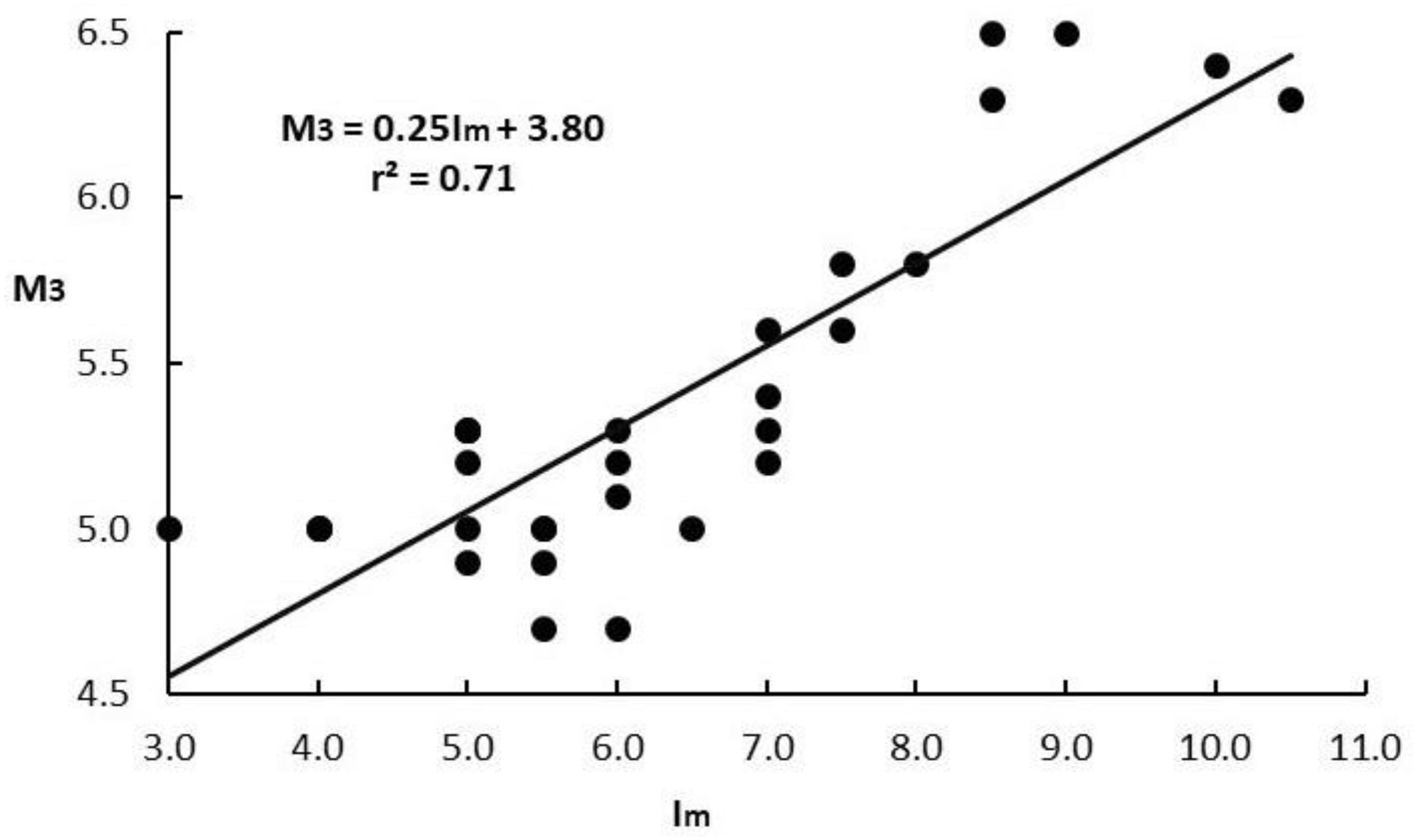
Figure 4.
Epicenters (red dots), years and magnitudes of the historical earthquakes examined. Key for localities: AM=Amaxiki, AV=Ayia Mavra, AP=Ayios Petros, AT=Athani, DA=Damiliani, DR=Dragano, EG=Eglouvi, EX=Exanthia, KL=Kalamitsi, KO=Komilio, KR=Karya, KT=Katouna, SE=Sesoula islet, SF=Sfakiotes, TS=Tsoukalades, VF=Vafkeri, VS=Vassiliki.
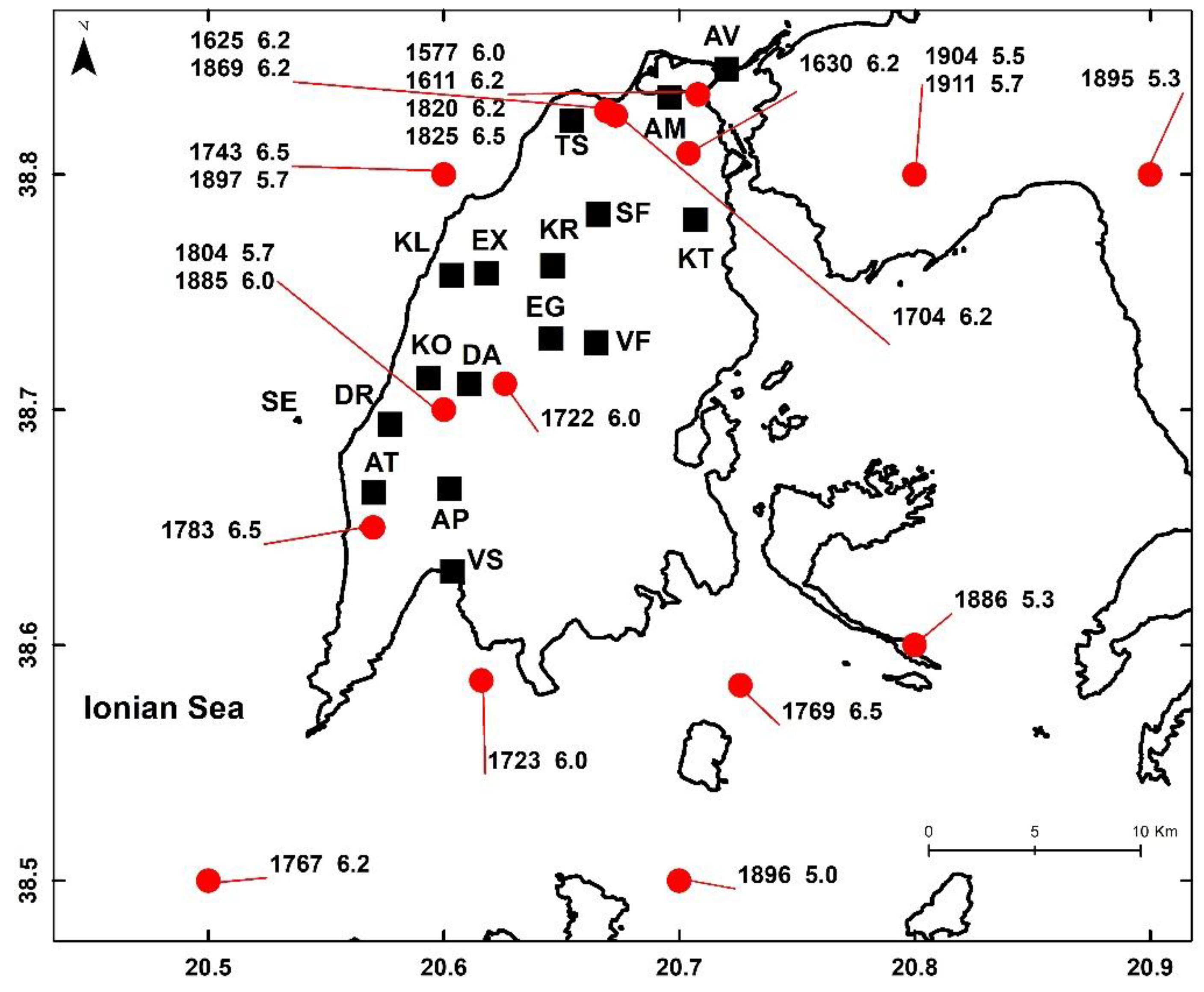
Figure 5.
Comparison of magnitudes Mw determined in this paper (blue vertical bars), with magnitudes MwP and MwS (orange vertical bars) determined by [22] for N=12 common earthquakes (a) and by [37] for N=9 common earthquakes (b).

Figure 6.
Comparison of intensities, Im, determined in this paper (vertical blue bars), with intensities, ImP determined by [22] (vertical orange bars) for N=12 common earthquakes (a), and with intensities, ImS (orange vertical bars) determined by [37] for N=9 common earthquakes (b).
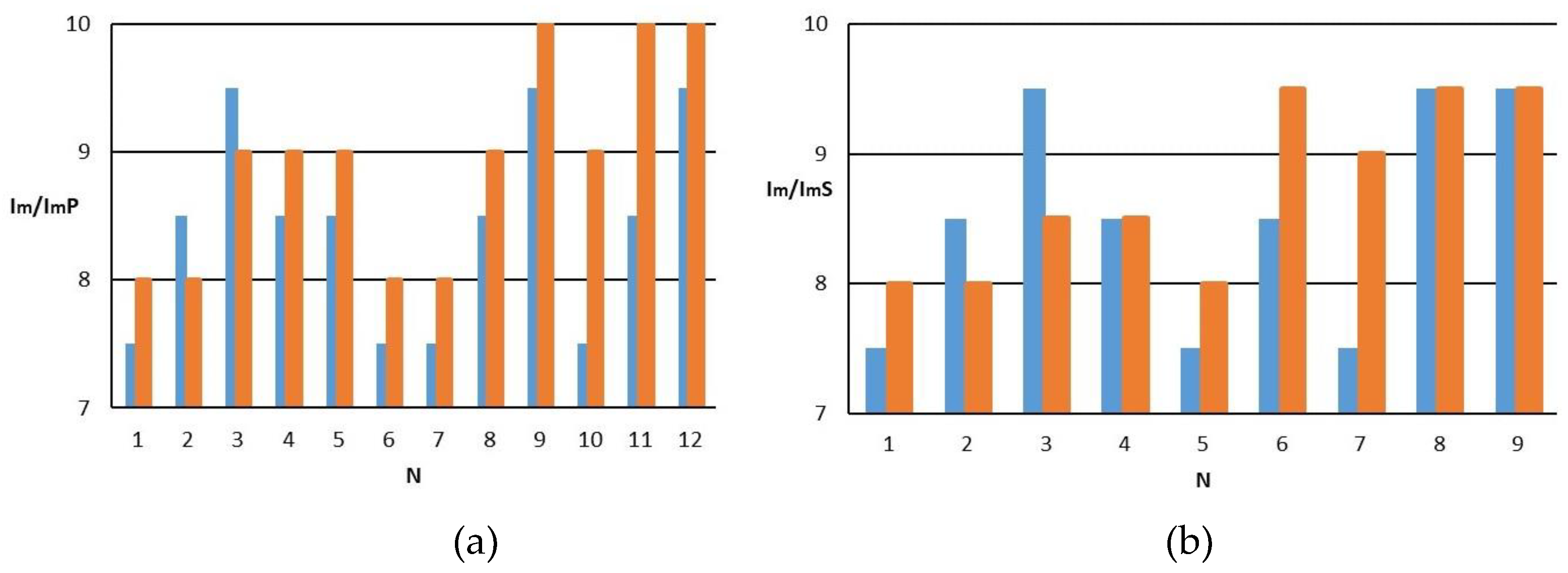
Figure 7.
Comparison of magnitudes Mw determined in this paper (blue vertical bars) with magnitudes MwP and MwS (orange vertical bars) determined by [22] for N=12 common earthquakes (a) and [37] for N=9 common earthquakes (b) with the use of our intensity assignments.
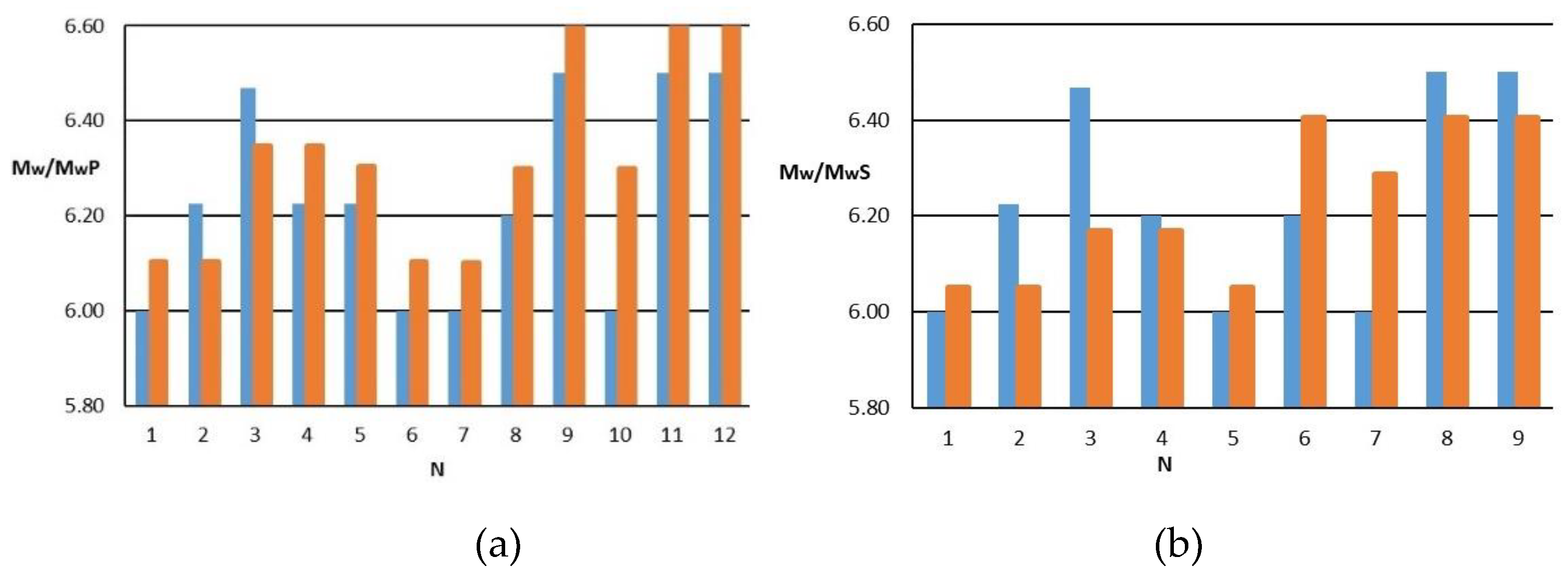
Figure 8.
Cumulative number, N, of all earthquakes (a) and of earthquakes of magnitude Mw≥6.0 (b) listed in the new historical catalogue for the area of Lefkada Isl.
Figure 8.
Cumulative number, N, of all earthquakes (a) and of earthquakes of magnitude Mw≥6.0 (b) listed in the new historical catalogue for the area of Lefkada Isl.
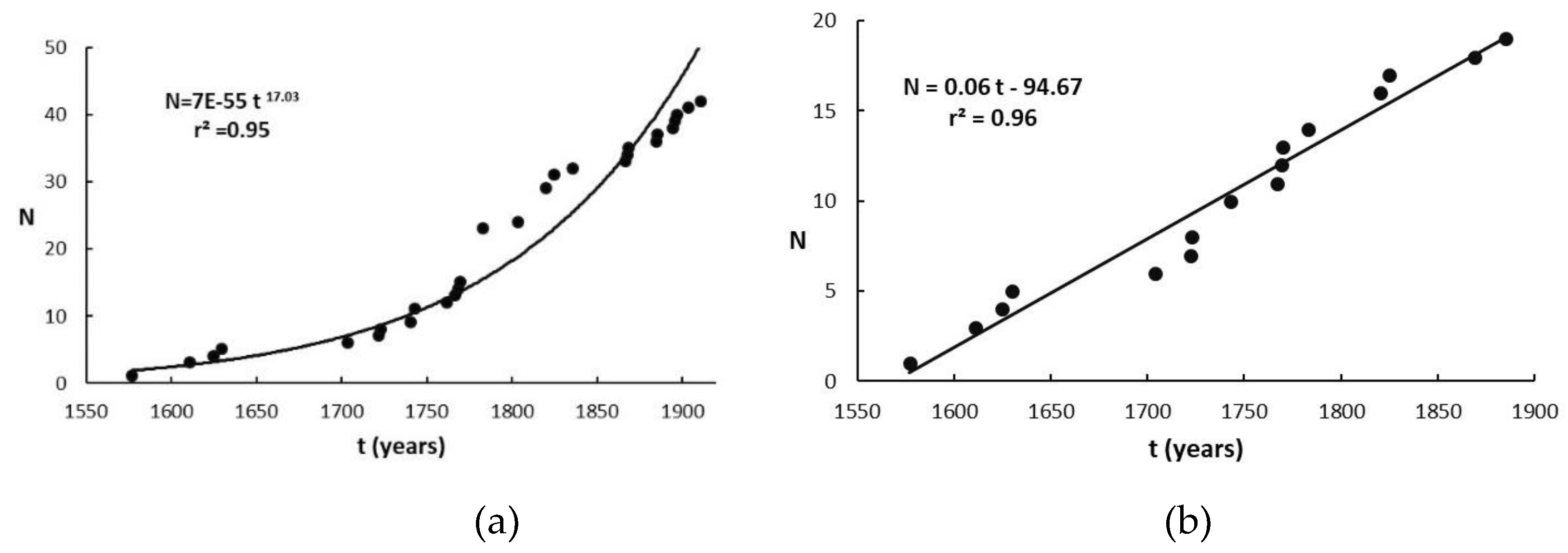
Disclaimer/Publisher’s Note: The statements, opinions and data contained in all publications are solely those of the individual author(s) and contributor(s) and not of MDPI and/or the editor(s). MDPI and/or the editor(s) disclaim responsibility for any injury to people or property resulting from any ideas, methods, instructions or products referred to in the content. |
© 2024 by the authors. Licensee MDPI, Basel, Switzerland. This article is an open access article distributed under the terms and conditions of the Creative Commons Attribution (CC BY) license (http://creativecommons.org/licenses/by/4.0/).
Copyright: This open access article is published under a Creative Commons CC BY 4.0 license, which permit the free download, distribution, and reuse, provided that the author and preprint are cited in any reuse.


