
Submitted:
26 November 2024
Posted:
27 November 2024
You are already at the latest version
Abstract
This study utilizes gamma-ray spectrometry to identify source areas of gold recognized in geo-chemical prospecting work in stream sediments. The local geological context is represented by the Passo Feio Metamorphic Complex, which contains gold deposits possibly hosted in quartz veins concordant with metamorphic foliation, composed of quartzites, schists, and amphibolites. The study followed the sequence: geological reconnaissance, drone survey, and gamma-ray spectro-metric acquisition. Field reconnaissance indicated an alternation of rocks oriented in a WNW/ENE direction, with recognition of quartz veins embedded concordantly with the foliation of quartzites. The drone data enabled the generation of a Digital Elevation Model (DEM) and served as a basis for planning the gamma-ray spectrometry work. A total of 715 gamma-ray spectrometric readings were taken, with an average spacing of 40 meters between points, followed by data processing and the generation of maps of K (%) concentrations, eU (ppm), and eTh (ppm). The data obtained re-garding the K (%) concentration values reveal a clear anomaly in the central region with WNW/ENE orientation. The concentration data obtained for U (ppm) and Th (ppm) show a similar pattern concerning the WNW/ENE anomaly in the center of the area. The overlap of positive anomalies served as an indication of gold source areas in two river valleys.
Keywords:
mineral prospecting
; gold
; geophysics
; gamma-ray spectrometry
1. Introduction
The exponential increase in demand for mineral resources has justified various research pro-jects and the discovery of multiple mineral deposits in Brazil, activities that have driven economic growth and social development. The global market demands a wide variety of mineral commodities, making Brazil a major exporter on a global scale. Consequently, maintaining this activity depends on constant research and discoveries.
Gold is one of the oldest financial assets, offering high liquidity and security. It is widely used as a reserve during periods of international crises, leading to significant price increases on stock exchanges [1,2]. In May 2024, the price of gold reached a historical record, with the ounce value climbing to $2,300, a significant increase compared to its average price of around $1,500 per ounce [2].
Gold consumption in Brazil has increased alongside the population's purchasing power, appearing in jewelry, electronic components for computers, tablets, notebooks, and mobile phones, as well as parts for the automotive industry, healthcare, dentistry, and even some construction components [3].
New mineral commodities are discovered through several progressive and interconnected steps, which involve and predict increased investment and decreased risk [4,5]. This process begins with the recognition of surface mineralization evidence, which may be associated with a subsurface ore body [5].
Geophysics is a highly mentioned tool in mineral exploration scenario for recognizing exploratory targets, since its field instruments allow for detecting contrasts between the physical properties of mineral deposits and their host rocks [6,7,8,9,10,11].
Gamma-ray spectrometry is a passive geophysical method, as it measures the inherent radioactivity in the form of gamma rays from mineral species containing radioactive isotopes such as potassium (40K), uranium (235U e 238U), and thorium (232Th) [8]. This method enables rapid and easy data acquisition, allowing for extensive area coverage, though it is a shallow method with a maximum investigation depth of 50 cm.
In mineral research, gamma-ray spectrometry is mainly applied to characteristically radioactive deposits, such as uranium or hydrothermal origin deposits [12,13,14,15]. Few references exist for studies related to gold deposits, primarily resulting from airborne geophysical surveys [16,17,18,19,20].
This work involved field reconnaissance, drone investigation, and terrestrial gamma-ray spectrometry in a detailed survey conducted in two watersheds to identify outcropping occurrences of gold, based on prior indications from geochemical surveys of sediments conducted by the Geological Survey of Brazil in southernmost Brazil.
2. Area Location and History
The study area is located in the southernmost of Brazil, in the state of Rio Grande do Sul (RS). The occurrence studied is around 15 km from the urban area of the municipality of Caçapava do Sul, which is approximately 240 km from Porto Alegre, the state capital (Figure 1).
Evidence of mineralization was recognized from regional studies carried out by the CPRM (Companhia de Pesquisa de Recursos Minerais, currently the Geological Service of Brazil) through the National Gold Prospecting Program in 2000, where geological reconnaissance and geochemical prospecting were carried out on stream sediments in an area of 136000 ha [21].
Two sub-basins with anomalous results for gold were selected as the target area for this study, based on the results of collecting samples of stream sediments and concentrates of heavy minerals in the alluvial material. There was a regional study on the area focused on defining anomalous basins, without detailing the origin of the gold [21]. Based on the premise of weathering in outcropping de-posits, followed by the transport of gold particles to the mouth regions of the basins, this work sought to follow the opposite path, based on an analysis of gamma-spectrometric data, in an attempt to recognize primary gold deposits in the study area.
3. Geology and Metallogenetic Origin
The study area encompasses rocks of the Caçapava do Sul Granitic Complex and the Passo Feio Metamorphic Complex, that are part of the igneous and metamorphic terrains that compose the Sul-Rio-Grandense Shield, formed during the Transamazonian (2.26–2.00 Ga) and Brasiliano (900–535 Ma) orogenic cycles [22].
The Caçapava do Sul Granitic Complex resulted from post-tectonic, calc-alkaline acidic magmatism, with its intrusion occurring at 562 ± 8 Ma during the late phases of the Brasiliano Orogeny evolution (Figure 2) [21,23]. Three granite rock facies are present: biotite granitoids, leucogranitoids, transitional granitoids, with crystals elongated in the N34W direction, the same as the metamorphic foliation of the Passo Feio Complex, which hosts the granitic complex [24].
The Passo Feio Metamorphic Complex consists of pelitic schists, phyllites, amphibolites, and metavolcanoclastic rocks and can be divided into a Metasedimentary Association and a Metavolcanic Association (Figure 2) [21,25]. It forms a doubly plunging antiform fold, with a sub-horizontal axis dipping towards NNE and SSW. The granitic complex intrudes its center, and the unit serves as the basement for the Camaquã Basin [23,26,27].
The Metasedimentary Association is composed of metapelites and metavolcanoclastic rocks, represented by schists and phyllites containing muscovite, biotite, and/or chlorite, as well as minerals such as garnet, chloritoid, and staurolite. The foliation of these rocks is characterized by schistosity or slaty cleavage. The schist bands vary in thickness and are intercalated with amphibolites, quartz-feldspathic gneisses, and thin quartzite layers [25].
The Metavolcanic Association includes amphibolites, amphibole schists, amphibole gneisses, and massive amphibolites. These rocks exhibit planar and continuous structures with banding generated by metamorphic segregation or are massive [25].
The metapelites and amphibolites underwent two regional metamorphic events (M1 and M2) and three deformational phases (D1, D2, and D3), and among these, D3 is not associated with regional metamorphism [25,28]. The D1 phase is preserved in quartz lenses, D2 formed the S2 foliation, and D3 created folds structuring the Passo Feio Metamorphic Complex.
The M1 event was characterized by the presence of minerals in the staurolite zone (amphibolite facies) and andalusite, indicative of a low-pressure event [24]. Metapelites and amphibolites are associated with M1, while M2 was a retrogressive event in the greenschist facies [24]. The Caçapava Granite intrusion occurred between the D2-M2 interval, with the S2 foliation of metamorphic rocks correlating with that of the granite. The ages of M1 and M2 were estimated at 685 ± 12 Ma and 562 ± 8 Ma, respectively [23].
The Passo Feio Metamorphic Complex hosts Cu (Au) and Pb mineralizations. The target of this study is a disseminated gold occurrence hosted in quartz veins concordant with the foliation of the host rock and associated with shear zones, with its paragenesis consisting of quartz, gold, pyrite, arsenopyrite, and chalcopyrite, classified as epigenetic hydrothermal deposits [21,29].
The hydrothermal processes associated with the intrusion of the Caçapava do Sul Granitic Complex were responsible for the sulfide mineralization under study. Thermal fluids of magmatic origin mobilized metals from rocks adjacent to the Passo Feio Complex and deposited them in veins [23]. The deposits within the Metamorphic Complex are structurally controlled by NE-oriented strike-slip fault systems, formed during the Neoproterozoic collision processes involved in the formation of the Dom Feliciano Belt [30].
4. Methods
This study was conducted through geological reconnaissance, drone surveys, and gamma-ray spectrometry investigation. The work began with the geological reconnaissance of the region, conducted in a N-S direction along a road that crosses orthogonally to the foliation present in the outcrops. Simultaneously, structural measurements of fractures and metamorphic foliations were collected to identify a possible direct or indirect relationship between the measured structures and the occurrence of gold.
Next, drone surveys were conducted using a DJI MAVIC 3T model, flying at an altitude of 120 meters (Figure 3). Two flights were performed: one over the higher terrain and another over the lower terrain. The resulting images were combined using Agisoft Metashape software, which integrates the imported drone images. This process generated a digital point cloud that allowed for the measurement of altitude for each orthophoto. Through the interpolation of these altitude values, a Digital Elevation Model (DEM) was created.
Based on the results of the drone surveys, the investigation area was delineated for geophysical surveying. The method employed was gamma-ray spectrometry, using the RS-332 Multipurpose Gamma-Ray Spectrometer System by Radiation Solutions Inc. This device offers high sensitivity, thermal protection, ease of use, and an integrated GPS (Figure 4A). Additionally, the geophysical reading points were georeferenced using a differential GPS with 0.5-meter precision.
The RS-332 measures the inherent radioactivity that occurs naturally in the form of gamma rays emitted by mineral species containing radioactive isotopes such as cosmogenic nuclides like potassium (40K), uranium (235U e 238U), and thorium (232Th). The spectrometer operates within a measurement range of 30 keV to 3000 keV. The device's reading time can be configured as needed; for this study, it was set to 60 seconds. A study from 2014 determined that a 60-second reading time is reasonable for gamma-ray spectrometry analysis of volcanic rocks in the Paraná Basin using a similar device [31]. Similarly, another one effectively used a 60-second reading time to identify potential zones for acid mine drainage generation in uranium mine waste piles [32].
The selected area for data acquisition covered approximately 88 hectares, mostly covered by low vegetation and forests limited to drainage areas, with some points of exposed rock. Measurements were taken by directly placing the device on the surface of dry soil, avoiding moisture-related attenuation. Approximately 715 data points were collected, distributed in a regular grid at 40-meter intervals, with differential GPS guidance in the field.
After the data acquisition phase, processing was carried out using Geosoft's Oasis Montaj software to generate maps representing the radiometric distribution of eU, eTh, and K concentrations in the area. An interpolation of the collected data points was performed to create a two-dimensional representation of thorium, potassium, and uranium concentrations in terms of distance.
The interpolation process involved a least-squares approximation to smooth the discrepancies between field data and software-calculated values. A theoretical two-dimensional model was generated by segmenting the subsurface into rectangular blocks. The software automatically distributed and sized these blocks based on the data points' spatial distribution. The program calculates the concentrations based on the block model created from the comparison between the measured and modeled values, the parameters of these blocks are adjusted interactively until the apparent value agrees with the values acquired in the field.
The processed outputs were color-scaled maps representing each element's distribution, with potassium concentrations expressed as a percentage and eU and eTh concentrations in ppm. Additionally, ratio and ternary maps were generated and analyzed, however, they provided no further insights beyond those obtained from the original K, U, and Th maps.
5. Results and Discussion
The initial stage of geological reconnaissance followed a N-S direction and revealed an alternation of rocks, varying between quartzites, schists and amphibolites, with a repetitive pattern across the explored area (Figure 4B–D). Thus, it was expected that the geophysical data would show a standard pattern of alternation based on the local lithology, representing the area's background. Additionally, quartz veins were identified concordantly embedded in the quartzites' foliation, which are likely the hosts of the studied gold mineralization.
The drone flights produced a high-resolution orthophoto of the study area, superior to freely available satellite images, and a Digital Elevation Model (DEM) (Figure 5). These data were initially analyzed from a geomorphological perspective and later integrated with gamma-ray spectrometry data to assess the geochemical mobility of the analyzed elements. The primary source of gold is likely outcropping, and weathering processes have resulted in the release of gold particles, which were carried to the basin's mouth. The elevation difference in the study area is 127 meters, with the highest point in the southern portion (291 meters) and the lowest in the Passo Feio River region (164 meters).
The gamma-ray spectrometric acquisition was conducted alongside differential GPS surveying. This equipment provides more precise coordinates than the GPS integrated into the RS-332, with a margin of error of only 0.5 meters, that provided a better result for the regular grid of 40-meter intervals. Thus, it enabled the creation of the point map for gamma-ray spectrometry analysis (Figure 6).
This study began interpreting the data using the altimetry values obtained from the DEM. These values were analyzed concerning terrain morphology, weathering, and element mobility in the geological environment, as these factors are crucial for assessing radioelement distribution at the Earth's surface. Naturally, sediment transport caused by erosion and physical weathering moves materials from higher elevations to lower areas. Geochemical element mobilization occurs through leaching and hydrothermal fluid activity, following the same patterns of movement as discussed before [33,34,35].
Potassium (K) is a lithophile, incompatible (especially during magma crystallization), and volatile element with high environmental mobility, primarily occurring in granitoids [34,36]. Uranium (U) becomes mobile under hydrothermal and supergenic conditions [34,36]. Thorium (Th) is less abundant in the crust and typically measured in ppb or ppm [37,34]. The chemical fractionation of U and Th series members occurs during magmatic processes [36].
Geomorphology, weathering, erosion, and the source rock collectively control the radioelement distribution in surface materials, creating differences from the bedrock background. Processes include K depletion during pedogenesis, K and Th enrichment through silicification in schists, and reduced K values during schist pedogenesis [34]. Generally, radioelement mobilization varies based on ground-water flow and leaching, with K being significantly more mobile than U or Th in such scenarios [38]. A study characterized various mineral deposits using airborne gamma-ray spectrometry, including gold mineralization in metavolcanic/metasedimentary rocks with hydrothermal alteration (K enrich-ment), similar to the present study area [39].
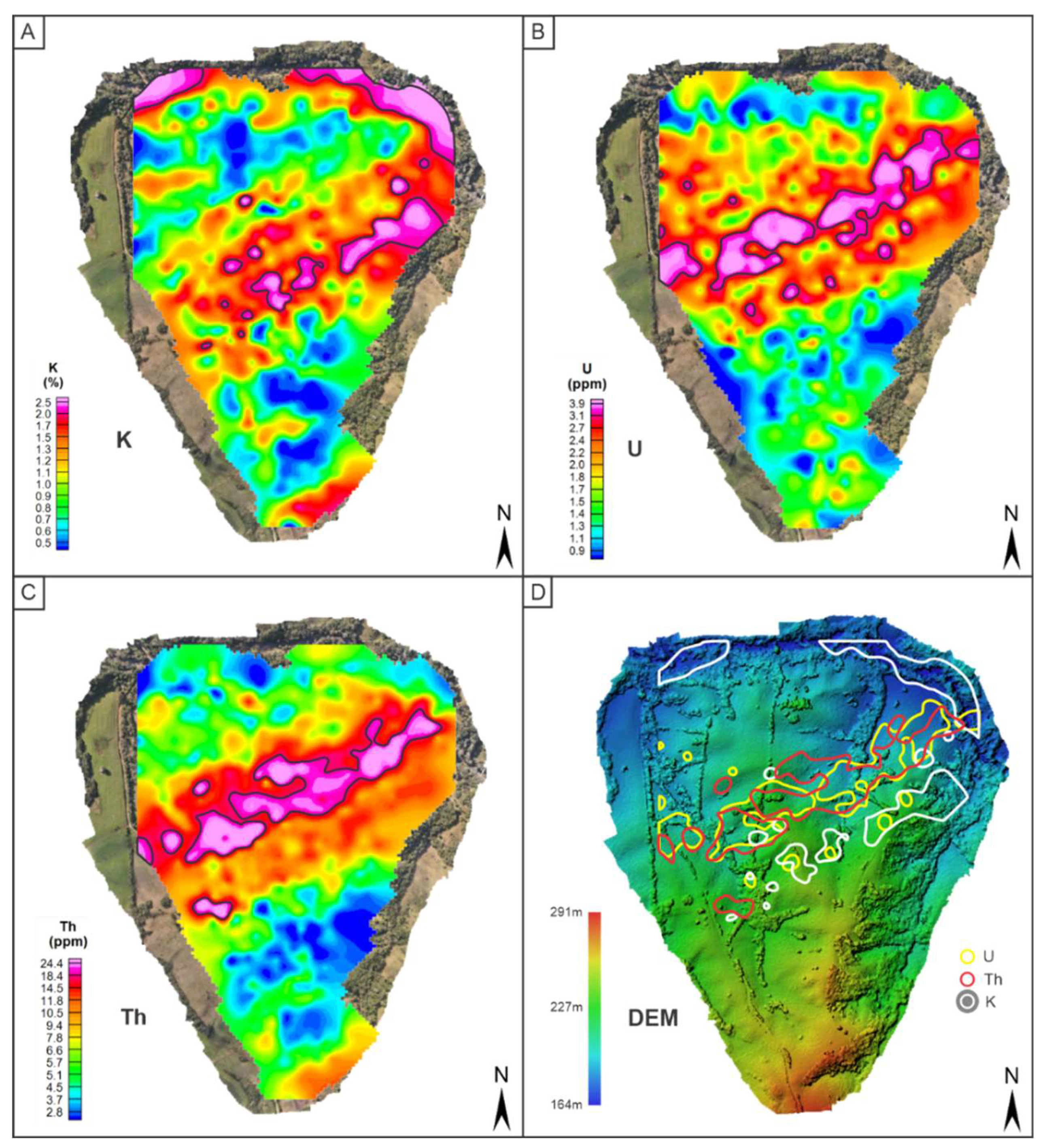
Potassium concentrations, expressed as percentages (%), ranged from 0.5% to 2.5% (Figure 7A). A noticeable anomaly with high concentrations (1.2–2.5%) is present in the central region, oriented NE/SW, coinciding with the quartizites' metamorphic foliation direction, mineralized quartz veins, and major regional fault zones. This area has undergone hydrothermal alteration due to the intrusion of the Caçapava do Sul Granitic Complex. Potassium is present in the micas forming the schists. Additionally, a high K concentration area is evident in the northern region (Figure 7A).
Uranium (U) and thorium (Th) concentrations, expressed in ppm, ranged from 0.9–3.9 ppm for U and 2.8–24.4 ppm for Th (Figure 7B,C). Compared to the K values, both show anomalies with a NE/SW orientation positioned in the central region of the area, however, the anomalous areas are not superimposed, with the eU and eTh anomalous areas shifting northwards (Figure 7D). U and Th originate exclusively from hydrothermal processes, as they are more abundant in the mantle and concentrated in the crust through magma ascent [33]. In the study area, this correlates with the regional hydrothermal event responsible for mobilizing U and Th and their subsequent deposition in mineralized quartz veins embedded in metamorphic foliation.
An integrated analysis of K, U, and Th maps reveals differences in each element's dispersion halos on the surface. In terms of mobility, K is the most mobile, U is intermediate, and Th is the least mobile under weathering processes. Soil thickness is a critical factor for element mobility, as greater thickness allows higher K, U, and Th concentrations to become available for mobilization. Geological reconnaissance revealed underdeveloped soils (up to 30 cm thick) rich in rock fragments at several points. Under such conditions, gamma-ray spectrometry anomalies primarily reflect signatures associated with the underlying rocks, whether related to original mineral composition or hydrothermal pro-cesses.
Two high K concentration regions or dispersion halos are evident. The Passo Feio River lies within a regional watershed, so the K anomaly in the floodplain may result from weathering in the study area's rocks or external factors, including the Caçapava do Sul Granitic Complex weathering.
For U, the highest concentration (3.1–3.9 ppm) is central, with some dispersion around it. Th shows a smaller dispersion halo with higher values (14.5–24.4 ppm), potentially representing or delineating a zone with gold mineralization in quartz veins.
To integrate the data, a map of anomalous halos for each element was generated and overlaid onto the DEM (Figure 7D). There is a coincidence between U and Th anomalies, with an absence of K in this domain, suggesting quartz vein emplacement in quartzites, which contain less K. Conversely, the K anomaly upstream of the U and Th halos may be associated with metasomatism and hydrothermalism in schists, a lithotype without quartz veins and likely barren of gold.
5. Conclusions
Stream sediment geochemistry data revealed two sub-basins with potential for primary gold occurrences. The data obtained in this study reveals the existence of a potentially mineralized area that crosses the two sub-basins, with an N70 orientation.
Studies describing the metallogeny of gold in the study region suggest a magmatic/hydrothermal origin that may have occurred during the sedimentation of the host rocks or during the closure and deformation phase of the sedimentary basin in the Neoproterozoic. The Caçapava do Sul Granitic Complex is barren for gold, but was possibly responsible for the last regional deformation of the Passo Feio Complex rocks and the reconcentration of gold in quartz veins embedded in the foliation and in quartzites fractures.
Anomalous halos for K were related to hydrothermal processes occurring in schists, with very low levels of U and Th, indicative of gold sterility, perhaps due to the lack of spaces for the generation of quartz veins. In this sense, quartizites represent the main lithotype or regional prospecting guide for gold searches.
The combined analysis of the digital terrain model with gamma spectrometry data has satisfactorily delimited potentially gold-mineralized targets, contained in a strip that crosses the two sub-basins recognized as anomalous in the geochemistry of stream sediments, and the probable primary outcrop-ping source of gold.
This combination of methods has proven effective in detailing targets from regional geochemical prospecting projects, and should be succeeded by deep investigation geophysical surveys, trenches or boreholes drillings, either for analysis of target architecture or definition of contents.
Author Contributions
Conceptualization, L.L.A and C.A.M; methodology, L.L.A and C.A.M; software, L.M.I.; investigation, L.L.A., C.A.M., A.F.S.A., L.M.I., S. K., M.A.F.H.; H.M.; writing—original draft preparation, L.L.A.; writing—review and editing, L.L.A., C.A.M.; supervision, C.A.M.; project administration, C.A.M. and H.M.
Funding
The this research was funded by FAPESP—Fundação de Amparo a Pesquisa do Estado de São Paulo (Process n. 2023/04732-8).
Data Availability Statement
The data that support the findings of this study are available on request from the corresponding author, Luiza Lima Alves.
Acknowledgments
The authors are especially grateful to the Fundação de Amparo à Pesquisa do Estado de São Paulo - FAPESP for funding the field trip of the Project. We also would like to thank the Coordenação de Aperfeiçoamento de Pessoal de Nível Superior (CAPES) for financial support on the masterfs’ scholarship of Luiza Lima Alves. We are also thankful for the support provided by Universidade Federal do Pampa, Campus de Caçapava do Sul – UNIPAMPA.
Conflicts of Interest
The authors declare no conflicts of interest.
References
- IBRAM – Instituto Brasileiro De Mineração. Informações e Análises da Economia Mineral Brasileira. 2012. Available online: https://ibram.org.br/wp-content/uploads/2020/12/informacoes-sobre-a-economia-mineral-2017.pdf (accessed on 30 June 2024).
- KITCO. Gold Price Today. Available online: https://www.kitco.com/gold-price-today-usa/ (accessed on 10 July 2024).
- World Gold Council. 2024. Available online: https://www.gold.org/ (accessed on 5 November 2024).
- Moon, C.J.; Whateley, M.K.; Evans, A.M. Introduction to Mineral Exploration, 2nd ed.; Blackwell Publishing: Hoboken, United States, 2006. [Google Scholar]
- Marjoribanks, R. Geological methods in mineral exploration and mining, 2nd ed.; Springer: Heidel-berg, Germany, 2010. [Google Scholar]
- Mussett A., E.; Khan M., A. Looking into the Earth: an introduction to geological geophysics, 1st ed.; Cambridge University Press: New York, United States, 2000. [Google Scholar]
- Ford K.; Keating P.; Thomas M. D. Overview of geophysical signatures associated with Canadian ore deposits. In: Mineral Deposits of Canada: A Synthesis of Major Deposit-types, District Metallogeny, the Evolution of Geological Provinces, and Exploration Methods. Geological Association of Canada, Mineral Deposits Division, Special Publication. 2007. pp. 939–970.
- Dentith M. And Mudge St. Geophysics for the Mineral Exploration Geoscientist, 1st ed.; Cambridge University Press: New York, United States, 2014; pp. 1-438.
- Lu, Db.; Wang, F.; Chen, Xd. et al. An Improved ERT Approach for the Investigation of Subsurface Structures. Pure Appl. Geophysics. 2017. 174, pp. 375-386. [CrossRef]
- Kühn, C.; Brasse, H. & Schwarz, G. Three-Dimensional Electrical Resistivity Image of the Volcan-ic Arc in Northern Chile—An Appraisal of Early Magnetotelluric Data. Pure Appl. Geophys. 2017. 175, pp. 2153-2165. [CrossRef]
- Zhang, G.; Lü, Qt.; Zhang, Gb.; Lin Pr. Jia Zy.; Suo K. Joint Interpretation of Geological, Magnetic, AMT, and ERT Data for Mineral Exploration in the Northeast of Inner Mongolia, China. Pure Appl. Geophys. 2017. 175, pp. 989-1002. [CrossRef]
- Shives, R. B. K.; Charbonneau, B. W.; & Ford, K. L. The detection of potassic alteration by gamma-ray spectrometry—Recognition of alteration related to mineralization. GEOPHYSICS. 2000. 65(6), pp. 2001–2011. [CrossRef]
- Gaafar, I. Application of gamma ray spectrometric measurements and VLF-EM data for tracing vein type uranium mineralization, El-Sela area, South Eastern Desert, Egypt, NRIAG. Journal of Astronomy and Geophysics. 2015. 4(2), pp. 266-282. [CrossRef]
- Elkhadragy A. A.; Ismail A. A.; Eltarras M. M.; Azzazy A. A. Utilization of airborne gamma ray spec-trometric data for radioactive mineral exploration of G.Abu Had – G.Umm Qaraf area, South Eastern Desert, Egypt, NRIAG. Journal of Astronomy and Geophysics. 2017. 6(1), pp. 148-161. [CrossRef]
- Alhumimidi, M. S.; Aboud, E.; Alqahtani, F.; Al-Battahien, A.; Saud, R.; Alqahtani, H. H.; Aljuhani, N.; Alyousif, M. M.; Alyousef, K. A. Gamma-ray spectrometric survey for mineral exploration at Baljurashi area, Saudi Arabia. Journal of Radiation Research and Applied Sciences. 2021. 14(1), pp. 82-90. [CrossRef]
- Maden, N.; Enver Akaryali. Gamma ray spectrometry for recognition of hydrothermal alteration zones related to a low sulfidation epithermal gold mineralization (eastern Pontides, NE Türki-ye). Journal of Applied Geophysics. 2015. 122, pp. 74–85.
- Pereira, B. M.; Jose, F. Recognition Of Gold Mineralization Favorability Zones Through Airborne Gamma-Ray Spectrometry And Magnetometry In Brusque And Botuverá Region, Southern Bra-zil. Brazilian Journal Of Geophysics. 2018. 36(3), pp. 361–361.
- Shebl, A.; Abdellatif, M.; Elkhateeb, S.O.; Csámer, Á. Multisource Data Analysis for Gold Potenti-ality Mapping of Atalla Area and Its Environs, Central Eastern Desert, Egypt. Minerals. 2021, 11(6), 641. [Google Scholar] [CrossRef]
- El-Sadek, M. A. Using of airborne gamma-ray spectrometric data to the exposure of potassic alteration -recognition of alteration relates to gold mineralization. Applied Radiation and Isotopes. 2022. 190, pp. 389-403. [CrossRef]
- Saleh, A.; Salako, K.A.; Salawu, N.B.; et al. Airborne magnetic and gamma-ray spectrometric pro-specting to delineate structures associated with gold mineralization—a case study in Yauri region, Northwestern, Nigeria. Arab J Geosci. 2023, 16, 308. [Google Scholar] [CrossRef]
- CPRM – Companhia de Pesquisa de Recursos Minerais. Programa Nacional de Prospecção de Ouro. Resultados da prospecção para ouro na área RS-01 Lavras do Sul/Caçapava do Sul, Subárea Caçapava do Sul, Rio Grande do Sul. Porto Alegre. 2000. 14p. https://rigeo.sgb.gov.br/handle/doc/1589.
- Soliani Junior, E.; Kawashita, K.; Baitelli, R. A Geologia Isotópica do Escudo Sul-rio-grandense - Parte I: métodos isotópicos e valor interpretativo. In Geologia do Rio Grande do Sul, 1st ed.; M. Holz, & L. F. Deros. Universidade Federal do Rio Grande do Sul: Porto Alegre, Brasil, 2000; pp. 161–174. [Google Scholar]
- Remus, M. V. D.; Hartmann, L. A.; Mcnaughton, N. J.; Groves, D. I. & Fletcher, I. R. The link be-tween hydrothermal epigenetic Copper mineralization and the Caçapava Granite of the Brasiliano Cy-cle in Southern Brazil. Journal of South American Earth Sciences. 2000. 13(3), pp. 191-216. [CrossRef]
- Nardi, L. V. S. & Bitencourt, M. F. Geologia, petrologia e geoquímica do Complexo Granítico de Caçapava do Sul, RS. Revista Brasileira de Geociências. 1989. 19(2), pp. 153-169.
- Bitencourt, M. F. Metamorfitos da região de Caçapava do Sul, RS – Geologia e Relações com o Corpo Granítico. In: Atas do 1º Simpósio Sul-Brasileiro de Geologia. 1983a. pp. 37-48.
- Paim, P. S. G.; Chemale Jr. F.; & Wildner, W. Estágios evolutivos da Bacia do Camaquã (RS). Ciência e Natura, Santa Maria. 2014. 36, pp. 183-193.
- Costa, E. O. Da; Bitencourt, M. F.; Tennholm, T.; Konopásek, J.; Moita, T. De F. P-T-D evolution of the southeast Passo Feio Complex and the meaning of the Caçapava Lineament, Dom Feliciano Belt, southernmost Brazil. Journal of South American Earth Sciences. 2021, 112(1), 103465. [Google Scholar] [CrossRef]
- Bitencourt, M. F. Geologia, Petrologia e Estrutura do Metamorfitos da Região de Caçapava do Sul, RS. Master Thesis, Programa de Pós-Graduação em Geociências, Instituto de Geociências, Univer-sidade Federal do Rio Grande do Sul, Porto Alegre, Brazil, 1983b.
- Toniolo, J. A.; Gil, C. A. A.; Sander, A. Projeto Baneo – Metalogenia das bacias neoproterozóico-eopaleozóicas do Sul do Brasil, Bacia do Camaquã. Serviço Geológico do Brasil: Porto Alegre, Brasil. 2007. pp. 138.
- Ribeiro, M.; Bocchi, P.R.; Figueiredo Filho, P.M.; Tessari, R.I. Geologia da quadrícula de Caçapava do Sul, RS, Brasil. Boletim da Divisão de Geologia e Mineralogia, DPM-DNPM. 1966. 127, pp. 1-232.
- Nardy, A. J. R.; Moreira, C.A.; Machado, F. B.; Luchetti, A. C. F.; Hansen, M. A. F.; Rossini, A. R.; Barbosa Jr, V. Gamma-Ray Spectometry Signature Of Paraná Volcanic Rocks: Preliminary Results. Geociências. 2014. 33(2), pp.216-227.
- Marques, A. C. G.; Moreira, C. A.; Casagrande, M. F. S.; Arcila, E. J. A. Gamma-ray spectrometry applied in the identification of potential acid mine drainage generation zones in waste rock pile with uranium ore and associated sulfides (Caldas, Brazil). Geofísica Internacional. 2022. 61(3), pp. 251-266. [CrossRef]
- Mcsween, H. Y.; Richardson, S. M.; Uhle, M. E. Geochemistry: Pathways and Processes. 2. ed. Co-lumbia University Press: New York, United States, 2003; pp. 363.
- Gilmore, G. Practical Gamma-Ray Spectrometry. 1. ed. John Wiley & Sons, Ltd.: United Kingdom, 2008, pp. 387.
- Macheyeki, A. S.; Li, X.; Kafumu, D. P.; Yuan, F. Applied Geochemistry: Advances In Mineral Exploration Techniques. 1st. ed.; Elsevier Inc.: Amsterdam, Netherlands, 2020; pp. 210.
- International Atomic Energy Agency (IAEA). Guidelines for radioelement mapping using gamma ray spectrometry data. Viena, Áustria, 2003. 172p.
- Dickson, B.L.; Scott, K.M. Interpretation of aerial gamma ray surveys-adding the geochemical factors. AGSO Journal of Australian Geology & Geophysics. 1997. 17(2), pp. 187- 200.
- Wilford, J.R.; Bierwirth, P.N.; Craig, M.A. Application of airborne gamma ray spectrometry in soil/regolith mapping and applied geomorphology. AGSO Journal of Australian Geology and Geophysics. 1997. 17(2), pp. 201-216.
- Shives, R.B.K.; Ford, K.L.; Charbonneau, B.W. Geological Survey of Canada Workshop Manual: Applications of Gamma ray Spectrometric/Magnetic/VLF-EM Surveys. Geological Survey of Canada. 1995. Open File 3061, pp. 85.
Figure 1.
Location of the study area in relation to the municipality of Caçapava do Sul (RS).
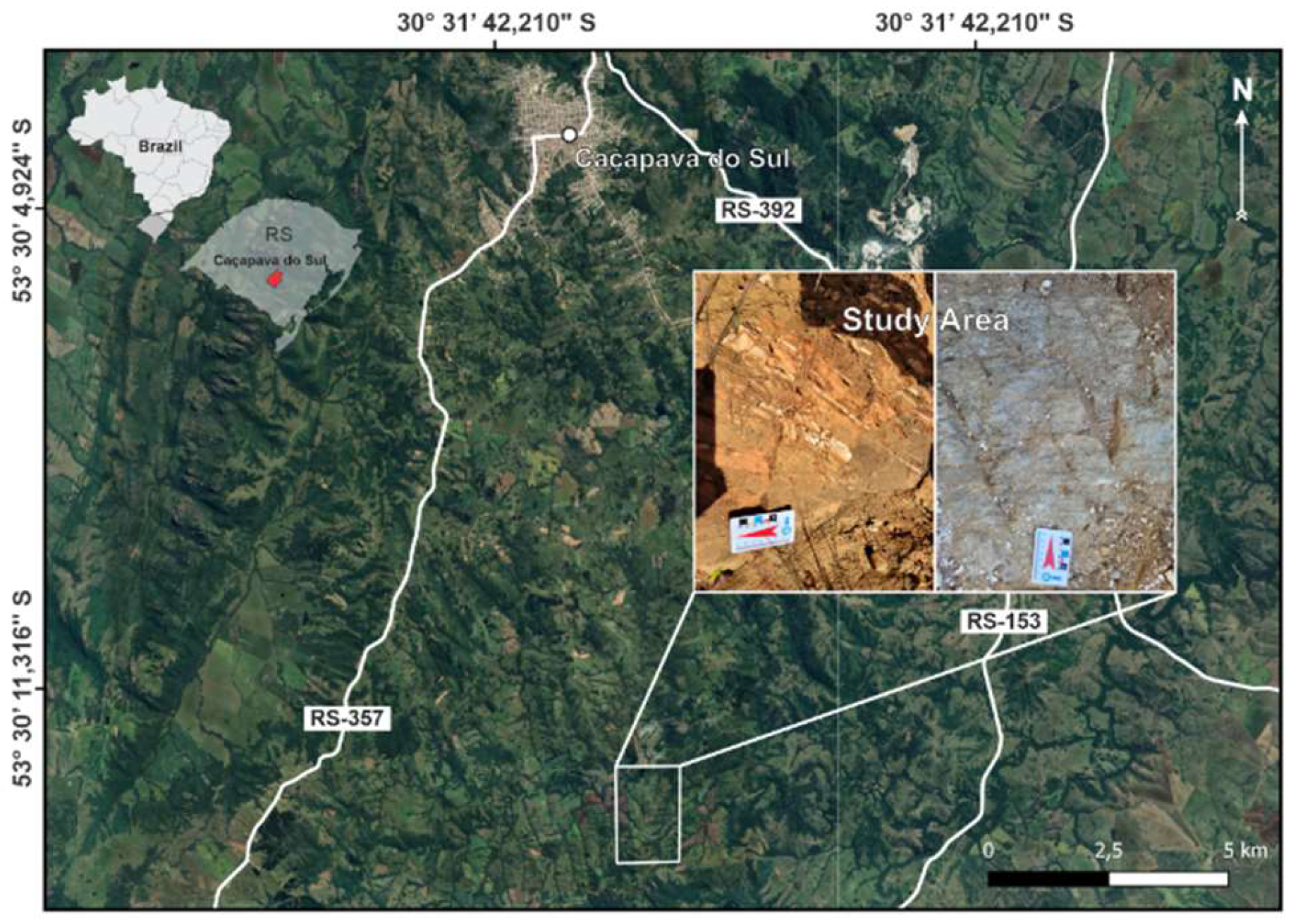
Figure 2.
Geological map (Modified from [21]).
Figure 2.
Geological map (Modified from [21]).
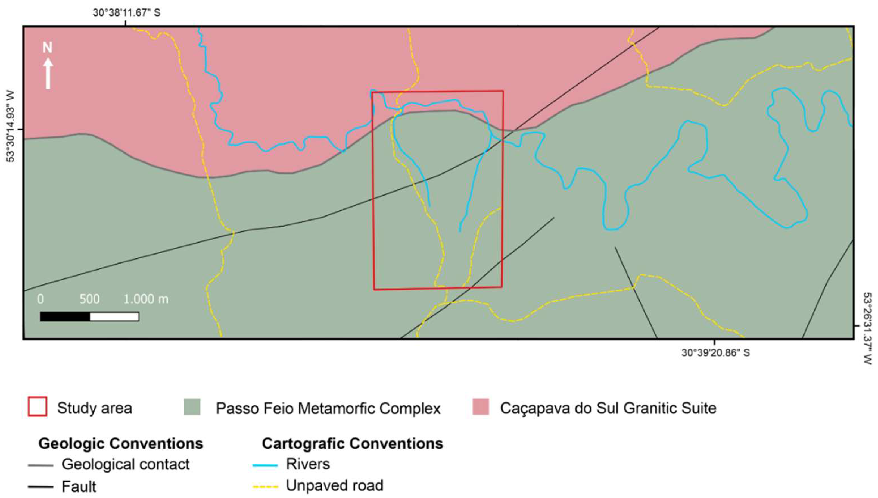
Figure 3.
Drone DJI MAVIC 3T.
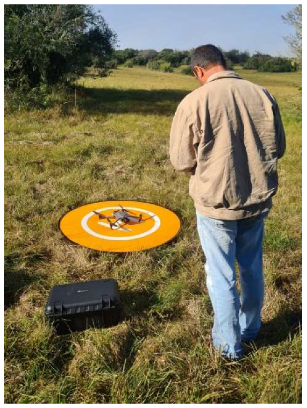
Figure 4.
(A) RS-332 conducting a measurement. (B) Quartzites with quartz veins embedded in metamorphic foliation. (C) Schists (D) Amphibolites.
Figure 4.
(A) RS-332 conducting a measurement. (B) Quartzites with quartz veins embedded in metamorphic foliation. (C) Schists (D) Amphibolites.
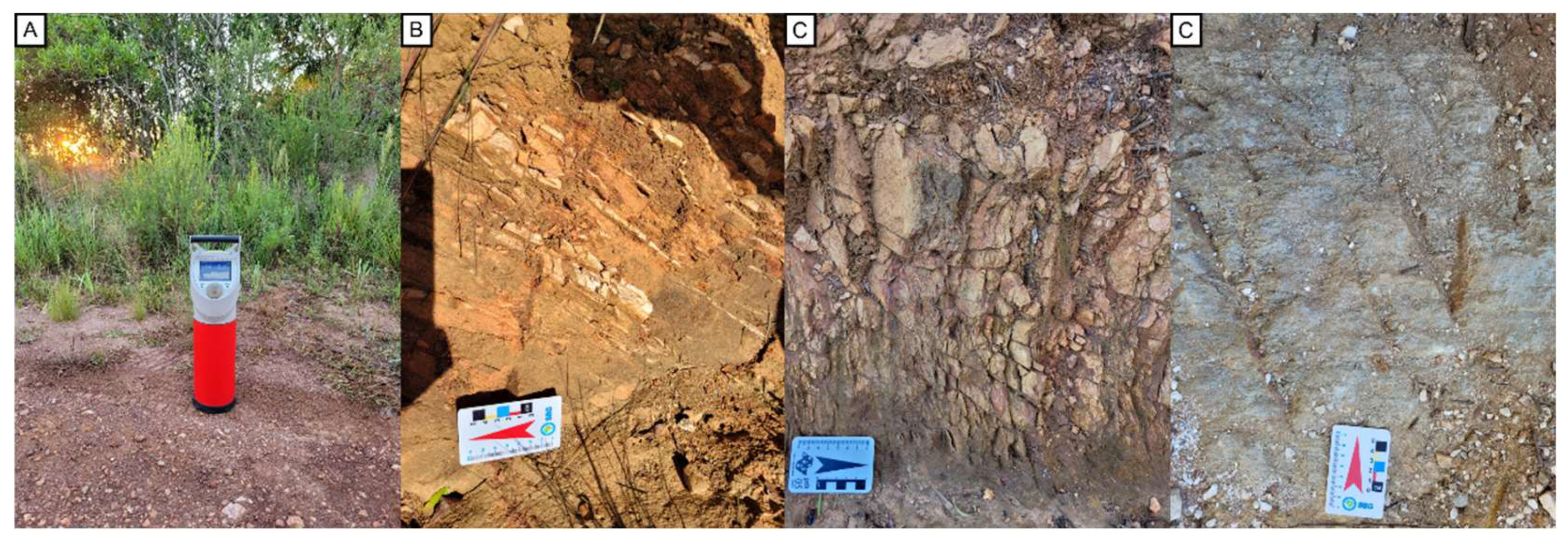
Figure 5.
Products from drone surveys and locations of [21] sampling points, showing the number of gold specks found in stream sediments. (A) Orthophoto of the study area. (B) DEM of the study area.
Figure 5.
Products from drone surveys and locations of [21] sampling points, showing the number of gold specks found in stream sediments. (A) Orthophoto of the study area. (B) DEM of the study area.
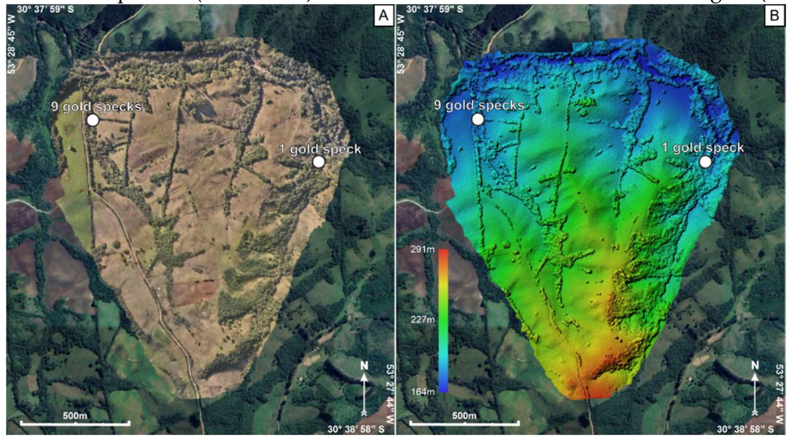
Figure 6.
Point map for gamma-ray spectrometry.
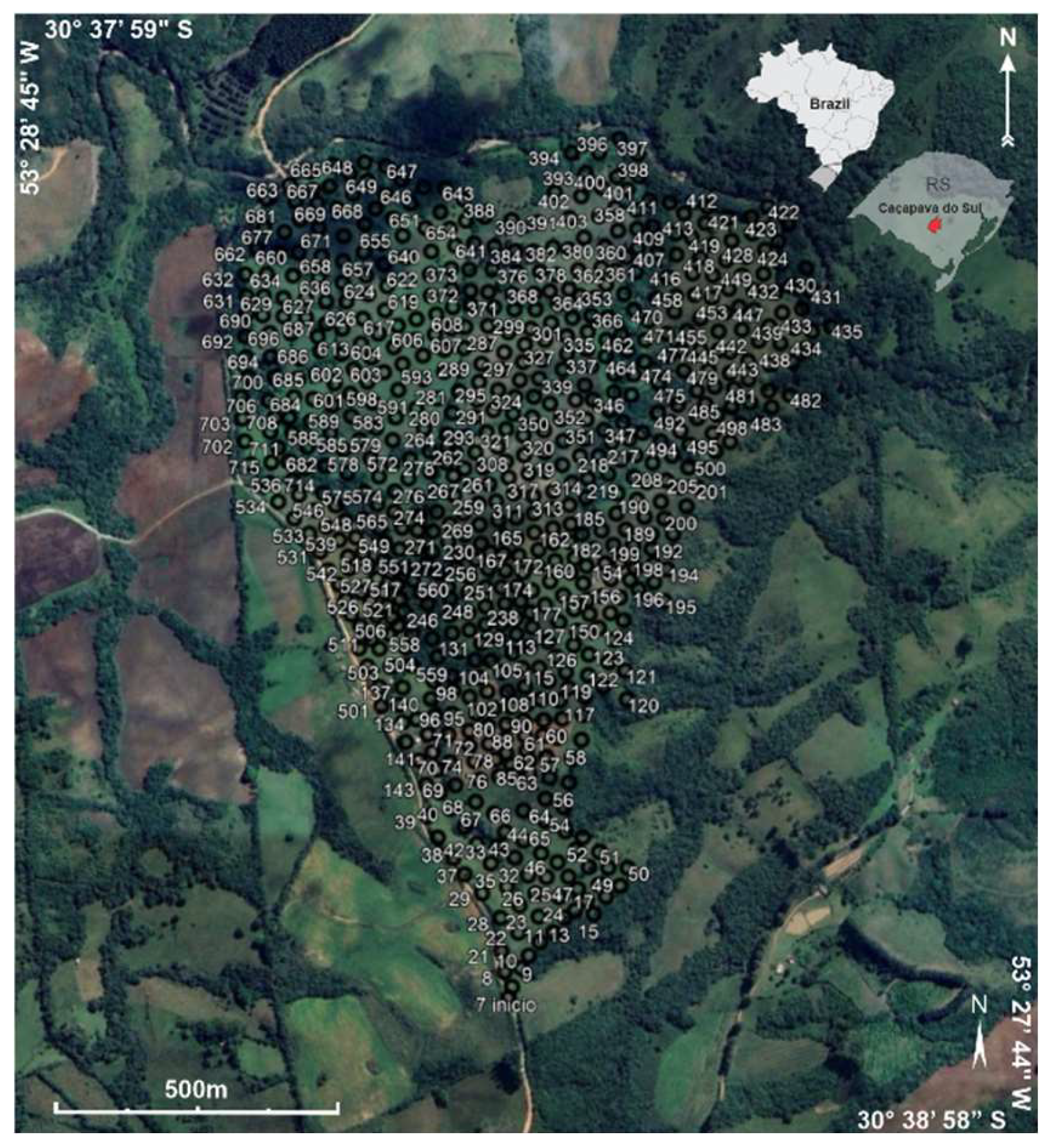
Figure 7.
(A) 2D interpolation map of K concentration, with the areas with the highest values highlighted in black. (B) 2D interpo-lation map of U concentration, with the areas with the highest values highlighted in black. (C) 2D interpolation map of Th concentration, with the areas with the highest values highlighted in black. (D) Areas with the highest element concentration values superimposed on the DEM.
Disclaimer/Publisher’s Note: The statements, opinions and data contained in all publications are solely those of the individual author(s) and contributor(s) and not of MDPI and/or the editor(s). MDPI and/or the editor(s) disclaim responsibility for any injury to people or property resulting from any ideas, methods, instructions or products referred to in the content. |
© 2024 by the authors. Licensee MDPI, Basel, Switzerland. This article is an open access article distributed under the terms and conditions of the Creative Commons Attribution (CC BY) license (http://creativecommons.org/licenses/by/4.0/).
Copyright: This open access article is published under a Creative Commons CC BY 4.0 license, which permit the free download, distribution, and reuse, provided that the author and preprint are cited in any reuse.


