

Submitted:
02 November 2024
Posted:
06 November 2024
You are already at the latest version
Abstract
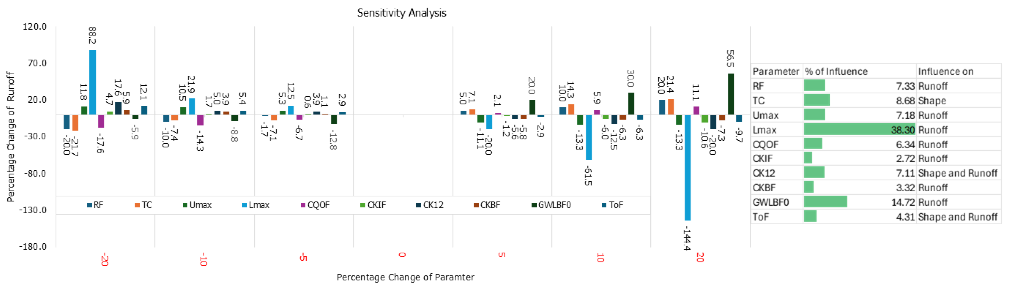
Dhaka, one of the fastest-growing megacities, is highly vulnerable to urban flooding due to rapid urbanization, inadequate drainage systems, and climate change-induced extreme weather events. This study describes the development of a comprehensive urban flood forecasting system for Dhaka City using the MIKE+ hydrodynamic model. The system integrates hydrological and hydraulic components, modeling complex interactions among surface runoff (pluvial), riverine overflow (fluvial), drainage networks, and overland flow dynamics. The model utilizes real-time data from river gauges, rainfall stations, and pump stations to enhance forecasting accuracy. Sensitivity analysis identified ten key parameters influencing model performance, which were adjusted during calibration. The model was calibrated and validated using historical flood events from 2019 to 2022, achieving strong performance metrics, including Nash-Sutcliffe Efficiency (NSE) greater than 0.65, Coefficient of Determination (R²) above 0.80, and Mean Absolute Error (MAE) less than 0.1 meters. The system was further tested using significant flood events from 2020 and 2021, cross-validated with flood marks and community-reported observations, ensuring reliability. This advanced urban flood forecasting tool supports decision-making and emergency response by providing early warnings and flood scenarios, enabling proactive flood management for a rapidly urbanizing city like Dhaka.
Keywords:
1. Introduction
2. Study Area
3. Necessity of Urban Flood Forecasting for Dhaka City
3.1. Causes of Flood
3.2. Impact of Recent Floods in Dhaka City
4. Approach, Methodology and Data Collection
4.1. Selection of Modelling Approach and Methodology
4.2. Data Source:
4.2.1. Data Collection for Rainfall Runoff Model
4.2.2. Data Collection for 1D Hydrodynamic Model
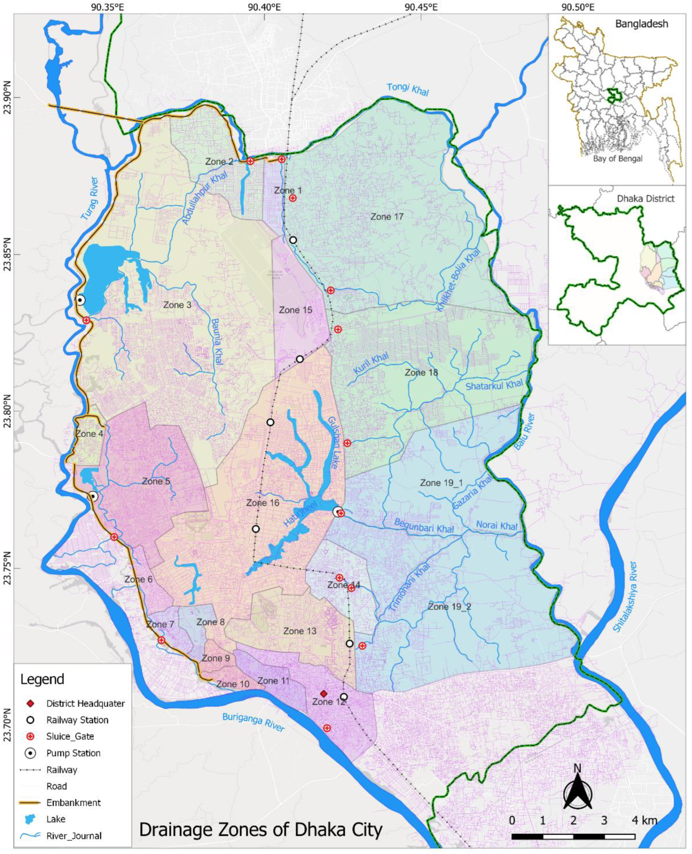
4.2.3. Data Collection for 2D Overland Flow Model
5. Model Development
5.1. Conceptual Background of Urban Flood Model:
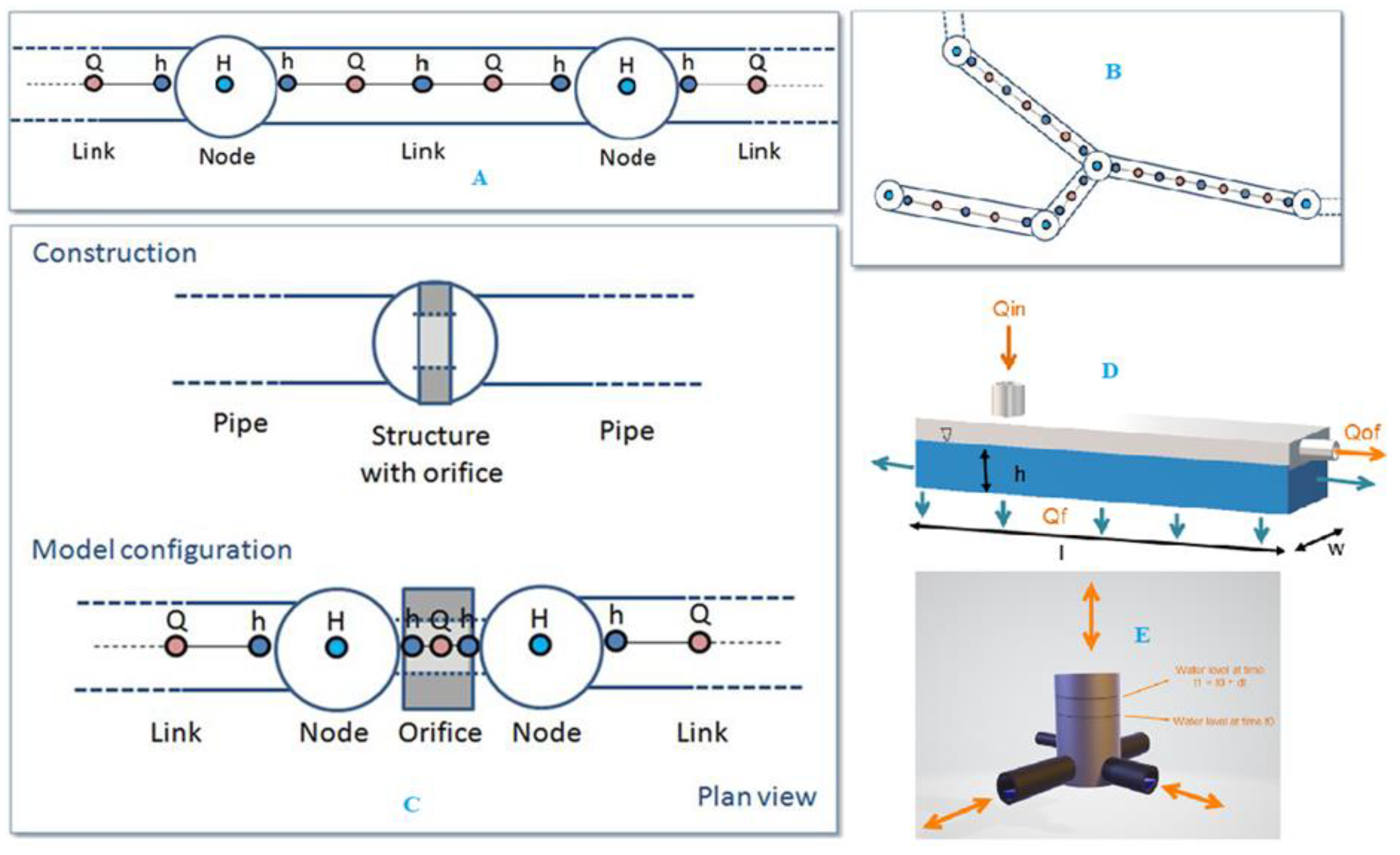
- Catchments
- Collection system network
- River network
- 2D overland
5.2. Rainfall Runoff Model
5.2.1. Surface Runoff Model
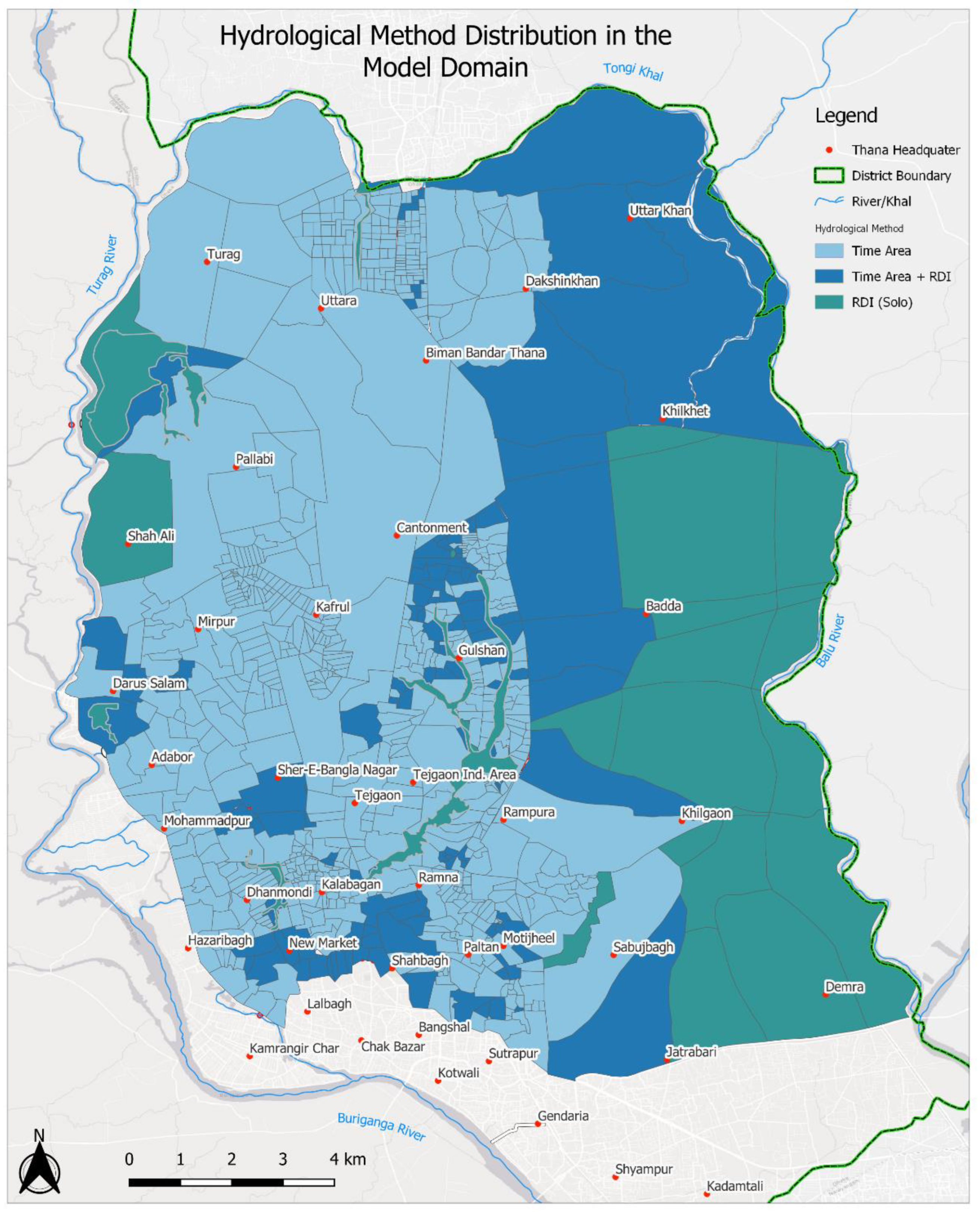
- Time-Area Method (A)
- Kinematic Wave (B)
- Linear Reservoir (C1 and C2)
- Unit Hydrograph Method (UHM)
5.2.2. Continuous Hydrological Model
5.2.3. Time-Area Method (A) for Surface Runoff Model
5.3. Conceptual Background of MIKE 1D Collection System
5.4. Conceptual Background of 2D Overland Flow

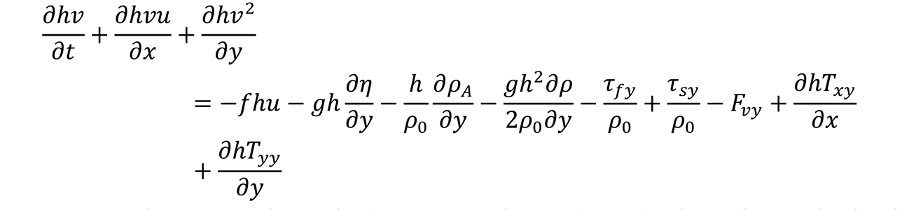
5.5. Conceptual Background of 1D/2D Overland Flow
5.6. Model Setup
- Catchment: A hydrological model for simulating surface runoff within the catchment using various methods of MIKE+.
- Collection system network: A 1D hydrodynamic model capable of simulating pressure flow and backwater effects in drainage systems with various structures, incorporating both stormwater and domestic water inputs.
- River Network: A pure 1D hydrodynamic model that operates simultaneously with the collection system and catchment runoff, enabling interaction between these systems.
- Overland Flows: A 2D hydrodynamic model for floodplains and urban areas that simulates surface flooding and dynamically interacts with the river network and collection system using different linking structures.
5.6.1. Surface Runoff Model
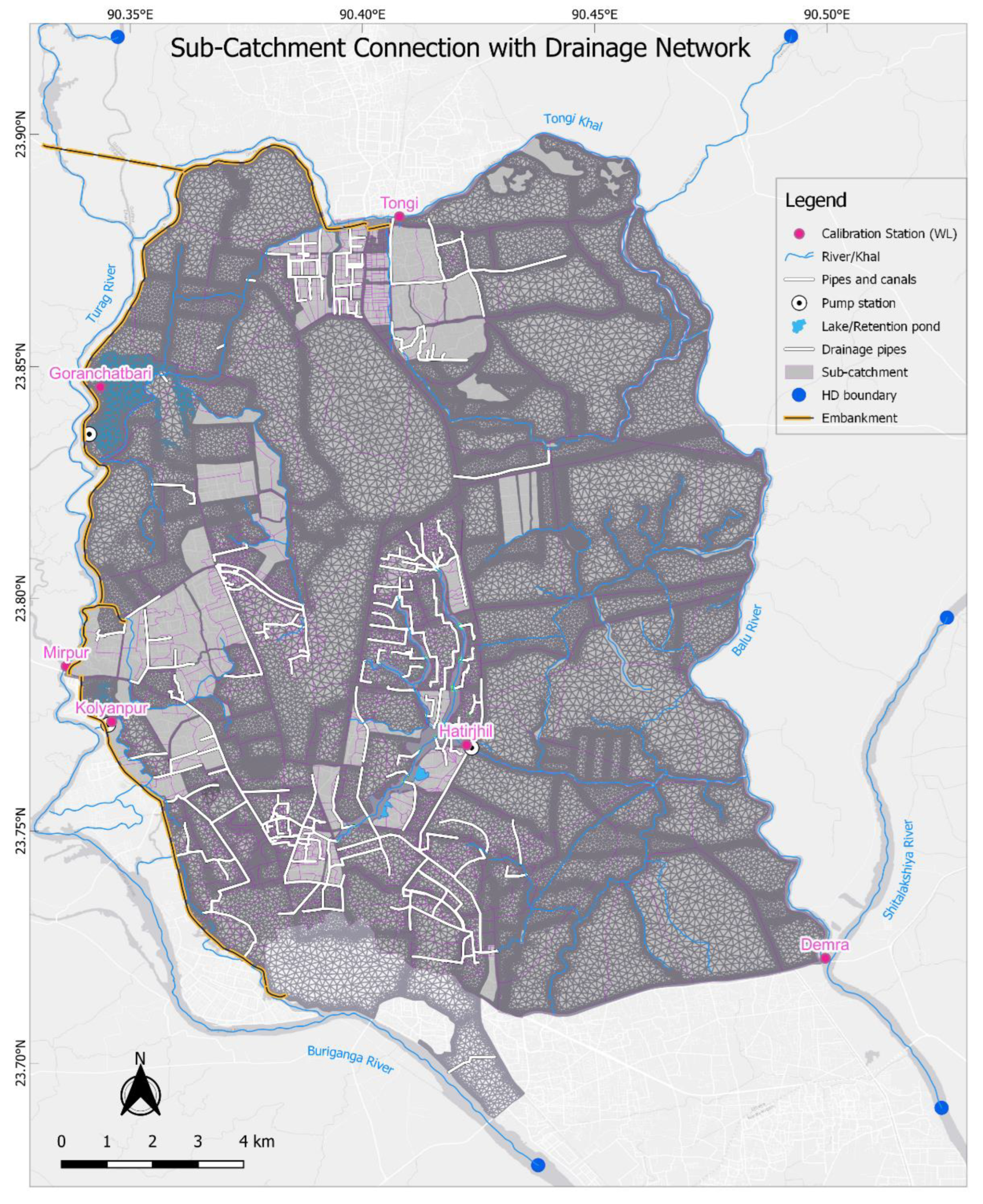
- Delineation of sub-catchments
- Choosing runoff model and parameters
- Connection with canal and river.
5.6.2. River Network
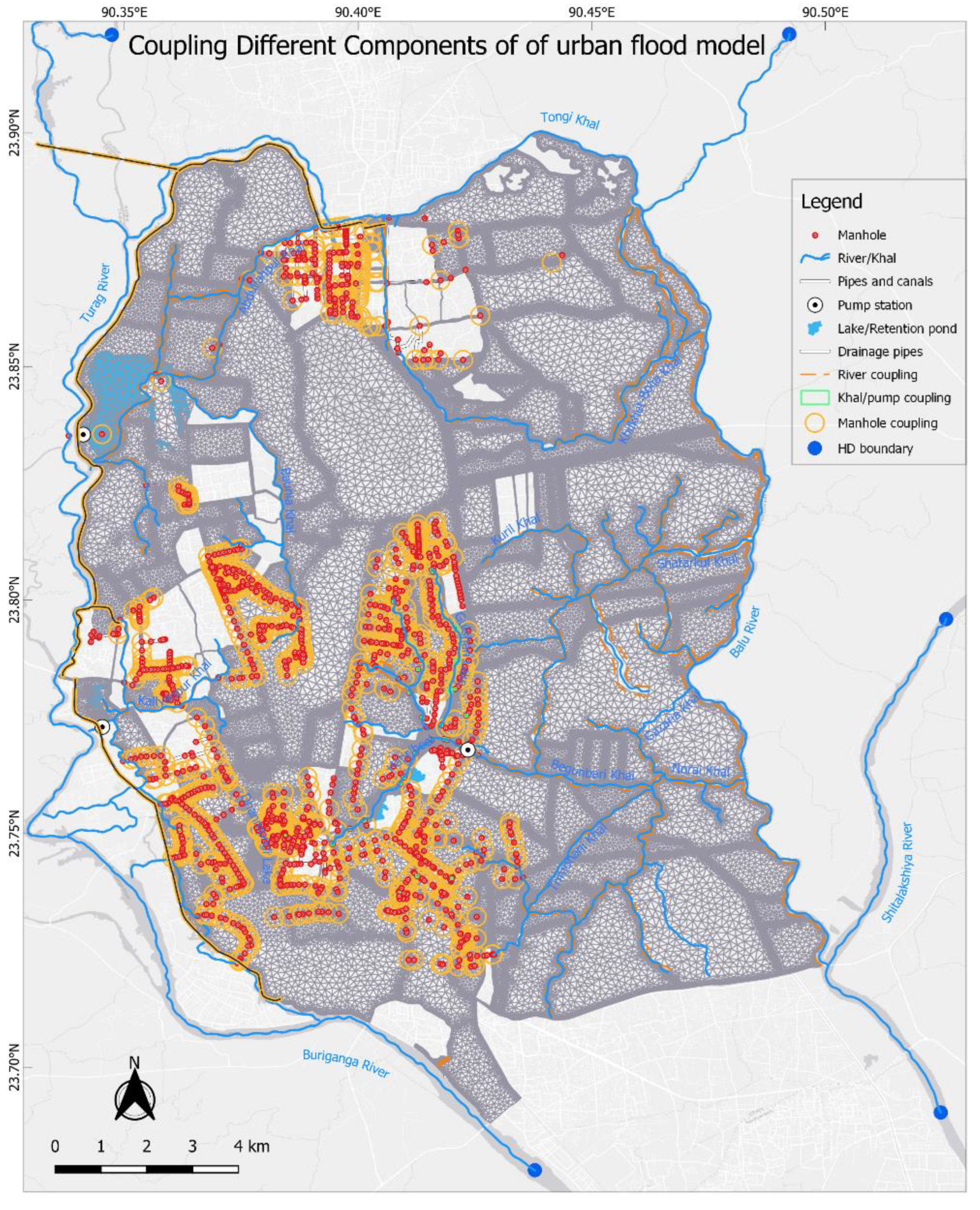
5.6.3. Cross-Section
5.6.4. Collection System
5.6.5. Mesh Generation
5.6.6. Develop 1D/2D Linked Urban Flood Forecasting Model
- Manhole
- Basin Outlet
- Pump
- Weir
- Natural channel
- River bank
- River end
5.6.7. Hydrological Boundary:
5.6.8. Wastewater Boundary Conditions
5.6.9. Peripheral River Boundary
5.7. Initial Condition
5.8. Calibration and Validation
5.8.1. Challenges in Model Calibration
5.8.2. Model Sensitivity and Calibration
5.8.3. Model Verification
6. Forecast Products
7. Discussion
8. Conclusions
8.1. Summary of Findings
8.2. Practical Implications of the Model
8.3. Future Outlook
- Higher resolution forecast data can be used to explore the model’s ability of detecting local convective rainfall events.
- Refined DEM can be used to examine the accuracy of the model.
- Acknowledging the need for a comprehensive approach, the study recommends the development of a hybrid model that integrates time-series data for machine learning-based algorithms with the expertise of numerical modeling.
- To develop a more realistic representation of blockage dynamics, a systematic approach integrating real-time monitoring data (e.g., using cameras or sensors to detect blockages) into the model, coupled with a rule-based dynamic adjustment of network capacities could be considered to improve the model’s ability to capture real-world drainage conditions under varying blockage scenarios.
- Though the design of flood forecasting and warning system (FFWS) is technical, its implementation depends on non-technical aspects as well. These include resource collection, evacuation planning, transportation facilities, warning dissemination, communication systems, electrical infrastructure, shelters, food and clothing supplies, medical resources, etc. Therefore, it is essential to integrate both technical and non-technical aspects seamlessly to reduce the casualties of floods.
Supplementary Materials
Author Contributions
Funding
Data Availability Statement
Acknowledgments
Conflicts of Interest
References
- Galloway, G.E.; Reilly, A.; Ryoo, S.; Riley, A.; Haslam, M.; Brody, S.; Highfield, W.; Gunn, J.; Rainey, J.; Parker, S. The growing threat of urban flooding: A national challenge. College Park and Galveston: University of Maryland and Texas A&M University 2018.
- Rainey, J.L.; Brody, S.D.; Galloway, G.E.; Highfield, W.E. Assessment of the growing threat of urban flooding: A case study of a national survey. Urban Water Journal 2021, 18, 375–381. [Google Scholar] [CrossRef]
- Trenberth, K.E. The Impact of Climate Change and Variability on Heavy Precipitation, Floods, and Droughts. In Encyclopedia of Hydrological Sciences; 2005.
- Eekhout, J.P.C.; Hunink, J.E.; Terink, W.; de Vente, J. Why increased extreme precipitation under climate change negatively affects water security. Hydrol. Earth Syst. Sci. 2018, 22, 5935–5946. [Google Scholar] [CrossRef]
- Tabari, H. Climate change impact on flood and extreme precipitation increases with water availability. Scientific Reports 2020, 10, 13768. [Google Scholar] [CrossRef]
- Willems, P.; Arnbjerg-Nielsen, K.; Olsson, J.; Nguyen, V.T.V. Climate change impact assessment on urban rainfall extremes and urban drainage: Methods and shortcomings. Atmospheric Research 2012, 103, 106–118. [Google Scholar] [CrossRef]
- Pregnolato, M.; Ford, A.; Robson, C.; Glenis, V.; Barr, S.; Dawson, R. Assessing urban strategies for reducing the impacts of extreme weather on infrastructure networks. Royal Society Open Science 2016, 3, 160023. [Google Scholar] [CrossRef]
- Rosenberg, E.A.; Keys, P.W.; Booth, D.B.; Hartley, D.; Burkey, J.; Steinemann, A.C.; Lettenmaier, D.P. Precipitation extremes and the impacts of climate change on stormwater infrastructure in Washington State. Climatic Change 2010, 102, 319–349. [Google Scholar] [CrossRef]
- Hossain, A.A.; Easson, G. Potential Impacts of the Growth of a Megacity in Southeast Asia: A Case Study on the City of Dhaka, Bangladesh. In Handbook of Climate Change Mitigation and Adaptation; Springer: 2022; pp. 2731–2758.
- Dasgupta, S.; Zaman, A.; Roy, S.; Huq, M.; Jahan, S.; Nishat, A. Urban Flooding of Greater Dhaka in a Changing Climate: Building local resilience to disaster risk; World Bank Publications: 2015.
- Ahmed, S.; Meenar, M.; Alam, A. Designing a Blue-Green Infrastructure (BGI) network: Toward water-sensitive urban growth planning in Dhaka, Bangladesh. Land 2019, 8, 138. [Google Scholar] [CrossRef]
- Khaleda, S.; Mowla, Q.A.; Murayama, Y. Dhaka metropolitan area. Urban Development in Asia and Africa: Geospatial Analysis of Metropolises 2017, 195-215.
- Gain, A.K.; Mojtahed, V.; Biscaro, C.; Balbi, S.; Giupponi, C. An integrated approach of flood risk assessment in the eastern part of Dhaka City. Natural Hazards 2015, 79, 1499–1530. [Google Scholar] [CrossRef]
- Siddiqua, A. Development of integrated landscape framework at land-water interface for water sensitive urban design in the eastern fringe of Dhaka metropolitan area. 2021.
- Mark, O.; Apirumanekul, C.; Kamal Mir, M.; Praydal, G. Modelling of Urban Flooding in Dhaka City. In Urban Drainage Modeling; Proceedings; 2012; pp. 333–343.
- Bakhtiari, V.; Piadeh, F.; Chen, A.S.; Behzadian, K. Stakeholder analysis in the application of cutting-edge digital visualisation technologies for urban flood risk management: A critical review. Expert Systems with Applications 2023, 121426. [Google Scholar] [CrossRef]
- Aljohani, F.H.; Alkhodre, A.B.; Sen, A.A.A.; Ramazan, M.S.; Alzahrani, B.; Siddiqui, M.S. Flood Prediction using Hydrologic and ML-based Modeling: A Systematic Review. International Journal of Advanced Computer Science & Applications 2023, 14. [Google Scholar] [CrossRef]
- Hallegatte, S.; Ranger, N.; Bhattacharya, S.; Bachu, M.; Priya, S.; Dhore, K.; Rafique, F.; Mathur, P.; Naville, N.; Henriet, F.; et al. Flood Risks, Climate Change Impacts and Adaptation Benefits in Mumbai. 2010. [Google Scholar] [CrossRef]
- Koetse, M.J.; Rietveld, P. The impact of climate change and weather on transport: An overview of empirical findings. Transportation Research Part D: Transport and Environment 2009, 14, 205–221. [Google Scholar] [CrossRef]
- Acosta-Coll, M.; Ballester-Merelo, F.; Martinez-Peiró, M.; De la Hoz-Franco, E. Real-time early warning system design for pluvial flash floods—A review. Sensors 2018, 18, 2255. [Google Scholar] [CrossRef] [PubMed]
- Bouramdane, A.-A. Enhancing disaster management in smart cities through MCDM-AHP analysis amid 21st century challenges. Information System and Smart City 2023, 3. [Google Scholar] [CrossRef]
- Ceenepalli, P.; Chandrasekhar, C. IoT-Enabled Flood Wall: Advancing Real-Time Flash Flood Monitoring and Forecasting. In Proceedings of the 2023 International Conference on Self Sustainable Artificial Intelligence Systems (ICSSAS); 2023; pp. 1369–1376. [Google Scholar]
- Taubenböck, H.; Esch, T.; Felbier, A.; Wiesner, M.; Roth, A.; Dech, S. Monitoring urbanization in mega cities from space. Remote sensing of Environment 2012, 117, 162–176. [Google Scholar] [CrossRef]
- Kabir, M.H.; Sato, M.; Habbiba, U.; Yousuf, T.B. Assessment of urban disaster resilience in Dhaka North City Corporation (DNCC), Bangladesh. Procedia engineering 2018, 212, 1107–1114. [Google Scholar] [CrossRef]
- Halder, A.; Majed, N. The effects of unplanned land use and heavy seasonal rainfall on the storm-water drainage in Dhaka metropolitan city of Bangladesh. Urban Water Journal 2023, 20, 707–722. [Google Scholar] [CrossRef]
- Rahman, S. Households' flood vulnerability assessment in context of climate change. University of Twente, 2011.
- Tawhid, K.G. Causes and effects of water logging in Dhaka City, Bangladesh. TRITA-LWR master thesis, Department of Land and Water Resource Engineering, Royal Institute of Technology, Stockholm.
- Dewan, A.M.; Islam, M.M.; Kumamoto, T.; Nishigaki, M. Evaluating flood hazard for land-use planning in greater Dhaka of Bangladesh using remote sensing and GIS techniques. Water resources management 2007, 21, 1601–1612. [Google Scholar] [CrossRef]
- Rahman, K.N.; Chisty, H.U.; Abedin, D.A.; Saha, A. Water in Cities: CAN WE END THE WAR?: Experiences from the Detailed Area Plan of Dhaka. In Handbook of Waterfront Cities and Urbanism; Routledge: 2022; pp. 222–238.
- Alam, S.; Jahan, S.; Noor, F. The surface water system, flood and water resources management of Bangladesh. Bangladesh Geosciences and Resources Potential 2022, 467–546. [Google Scholar]
- Baker, J.L. Climate change, disaster risk, and the urban poor: cities building resilience for a changing world; World Bank Publications: 2012.
- Shahid, S.; Wang, X.-J.; Harun, S.B.; Shamsudin, S.B.; Ismail, T.; Minhans, A. Climate variability and changes in the major cities of Bangladesh: observations, possible impacts and adaptation. Regional Environmental Change 2016, 16, 459–471. [Google Scholar] [CrossRef]
- Alam, M.; Rabbani, M.G. Vulnerabilities and responses to climate change for Dhaka. In Adapting Cities to Climate Change; Routledge: 2012; pp. 112–129.
- Rahman, A.A.; Alam, M.; Alam, S.S.; Uzzaman, M.R.; Rashid, M.; Rabbani, G. Risks, vulnerability and adaptation in Bangladesh. Human Development Report 2007, 8. [Google Scholar]
- Ahmed, F.; Moors, E.; Khan, M.S.A.; Warner, J.; Van Scheltinga, C.T. Tipping points in adaptation to urban flooding under climate change and urban growth: The case of the Dhaka megacity. Land Use Policy 2018, 79, 496–506. [Google Scholar] [CrossRef]
- Rahman, R.; Salehin, M. Flood risks and reduction approaches in Bangladesh. Disaster risk reduction approaches in Bangladesh 2013, 65–90. [Google Scholar]
- De Risi, R.; De Paola, F.; Turpie, J.; Kroeger, T. Life Cycle Cost and Return on Investment as complementary decision variables for urban flood risk management in developing countries. International journal of disaster risk reduction 2018, 28, 88–106. [Google Scholar] [CrossRef]
- Hossain, S.; Spurway, K.; Zwi, A.; Huq, N.; Mamun, R.; Islam, R.; Nowrin, I.; Ether, S.; Bonnitcha, J.; Dahal, N. What is the impact of urbanisation on risk of, and vulnerability to, natural disasters? What are the effective approaches for reducing exposure of urban population to disaster risks, EPPI-Centre. Social Science Research Unit, UCL Institute of Education, University College London, 2017. [Google Scholar]
- Rau, J.L.; Nutalaya, P. Geomorphology and land subsidence in Bangkok, Thailand. In Applied geomorphology; Routledge: 2020; pp. 181–201.
- Tingsanchali, T.; Promping, T. Comprehensive Assessment of Flood Hazard, Vulnerability, and Flood Risk at the Household Level in a Municipality Area: A Case Study of Nan Province, Thailand. Water 2022, 14, 161. [Google Scholar] [CrossRef]
- Regmi, R.K. Urbanization and related environmental issues of Metro Manila. Journal of Advanced College of Engineering and Management 2017, 3, 79–92. [Google Scholar] [CrossRef]
- Aerts, J.; Botzen, W.; Bowman, M.; Dircke, P.; Ward, P. Climate Adaptation and Flood Risk in Coastal Cities (Earthscan Climate). Water Resources Research 54.
- Akhter, S.; Syed, I.M.; Alam, M.S.; Mallik, M.; Hassan, S.Q.; Huque, S.M. Simulation of High Impact Monsoon Rainfall and its Thermodynamic Features over Bangladesh Using WRF Model.
- Mishra, R. Dam Breach Parameters and its Effects on Propagation of Flood Wave at the Downstream of Sarabgarh Irrigation Project. 2018.
- Timbadiya, P.; Patel, P.; Porey, P. One-dimensional hydrodynamic modelling of flooding and stage hydrographs in the lower Tapi River in India. Current science 2014, 708–716, https://www.jstor.org/stable/24099969. [Google Scholar]
- moni Boruah, M.T. Development of 1d and 2d Hydrodynamic Flood Model Using Mike Software by Dhi”. 2017. [CrossRef]
- Balmforth, D. Designing for exceedance in urban drainage: good practice; London: CIRIA: 2006.
- DHI, D.W.E. MIKE 21 & MIKE 3 Flow Model FM. 2023.
- Liu, J.; Li, Z.; Shao, W.; Yan, D.; Mei, C. Urban flood modelling in Qiqihar city based on MIKE flood. Proceedings of the International Association of Hydrological Sciences 2020, 383, 185–192. [Google Scholar] [CrossRef]
- Novak, P.; Moffat, A.; Nalluri, C.; Narayanan, R. Hydraulic structures; CRC Press: 2017.
- Liu, J.; Cai, J.; Yang, D.; Wang, X. A numerical visualization technique based on the hydraulic analogy. Journal of Visualization 2019, 22, 371–384. [Google Scholar] [CrossRef]
- Song, Y.; Huang, J.; Toorman, E.; Yang, G. Reconstruction of river topography for 3d hydrodynamic modelling using surveyed cross-sections: An improved algorithm. Water 2020, 12, 3539. [Google Scholar] [CrossRef]
- MIKE. MIKE 21 & MIKE 3 Flow Model FM.
- Metcalf; Eddy; Abu-Orf, M.; Bowden, G.; Burton, F.L.; Pfrang, W.; Stensel, H.D.; Tchobanoglous, G.; Tsuchihashi, R.; AECOM. Wastewater engineering: treatment and resource recovery; McGraw Hill Education: 2014.
- Sultana, T.; Magumdar, T.K. Consultancy Services for Expansion flood forecasting model (whole country) Improve inundation model in coastal and hotspot areas (depth and area of inundation); Institute of Water Modelling (IWM): Dhaka, 2024. [Google Scholar]
- Qiu, G.Y.; Zou, Z.; Li, X.; Li, H.; Guo, Q.; Yan, C.; Tan, S. Experimental studies on the effects of green space and evapotranspiration on urban heat island in a subtropical megacity in China. Habitat international 2017, 68, 30–42. [Google Scholar] [CrossRef]
- Rohinton, E.; Erik, J. Influence of urban morphology and sea breeze on hot humid microclimate: the case of Colombo, Sri Lanka. Climate Research 2006, 30, 189–200. [Google Scholar] [CrossRef]
- Akter, A.; Tanim, A.H. Estimating urban flood hazard zones using SWMM in Chittagong City. Technical Journal River Research Institute 2016, 13, 87–101. [Google Scholar]
- Shuvo, S.D.; Rashid, T.; Panda, S.K.; Das, S.; Quadir, D.A. Forecasting of pre-monsoon flash flood events in the northeastern Bangladesh using coupled hydrometeorological NWP modelling system. Meteorology and Atmospheric Physics 2021, 133, 1603–1625. [Google Scholar] [CrossRef]
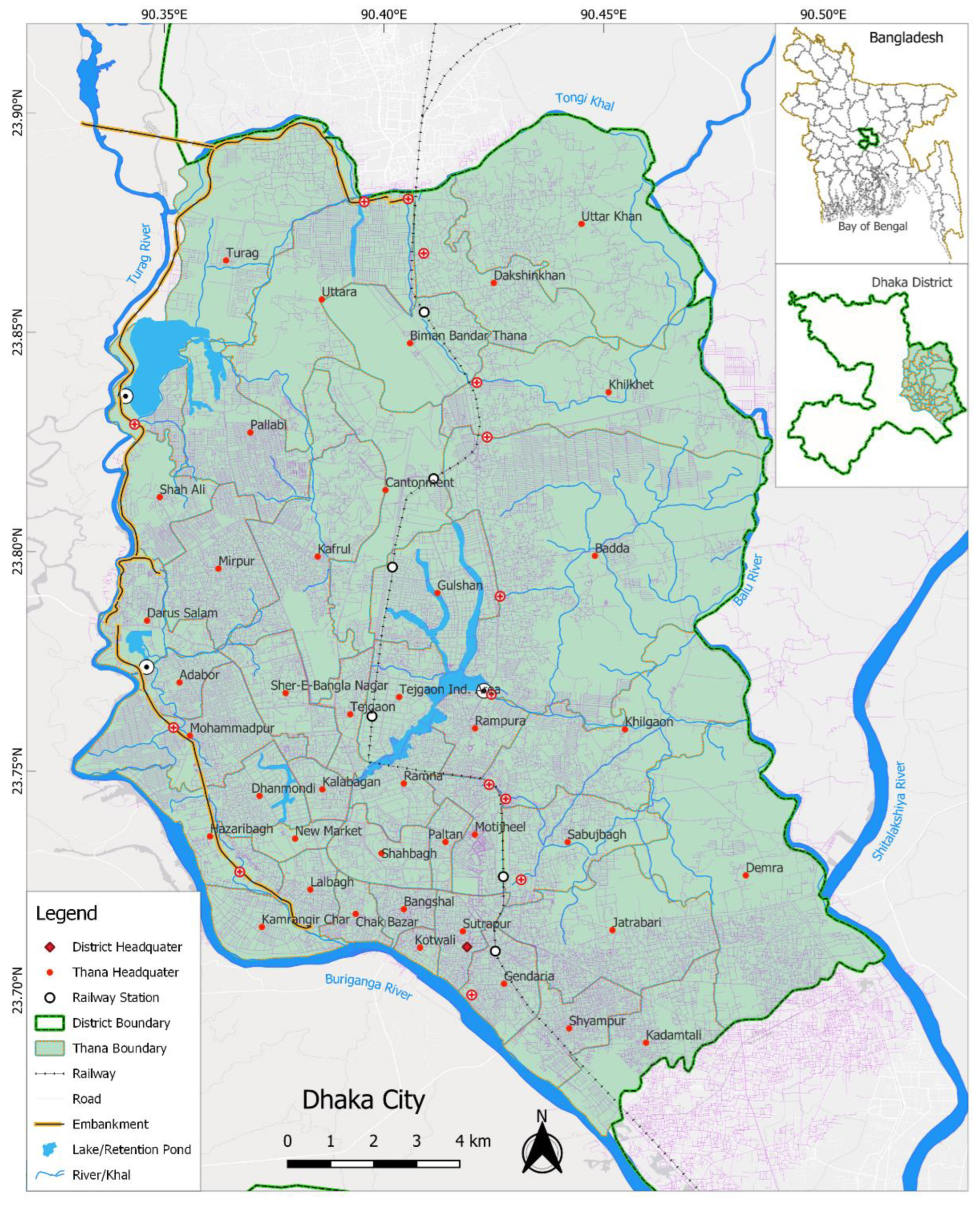
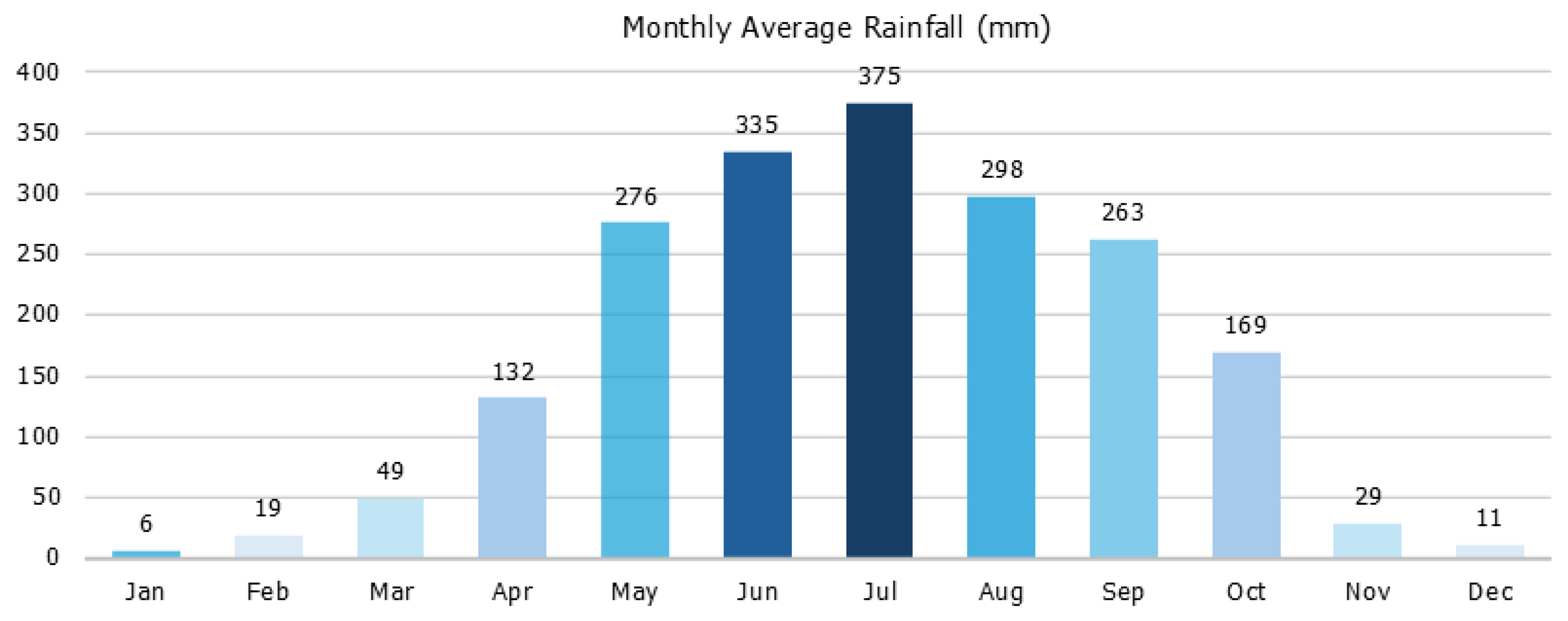
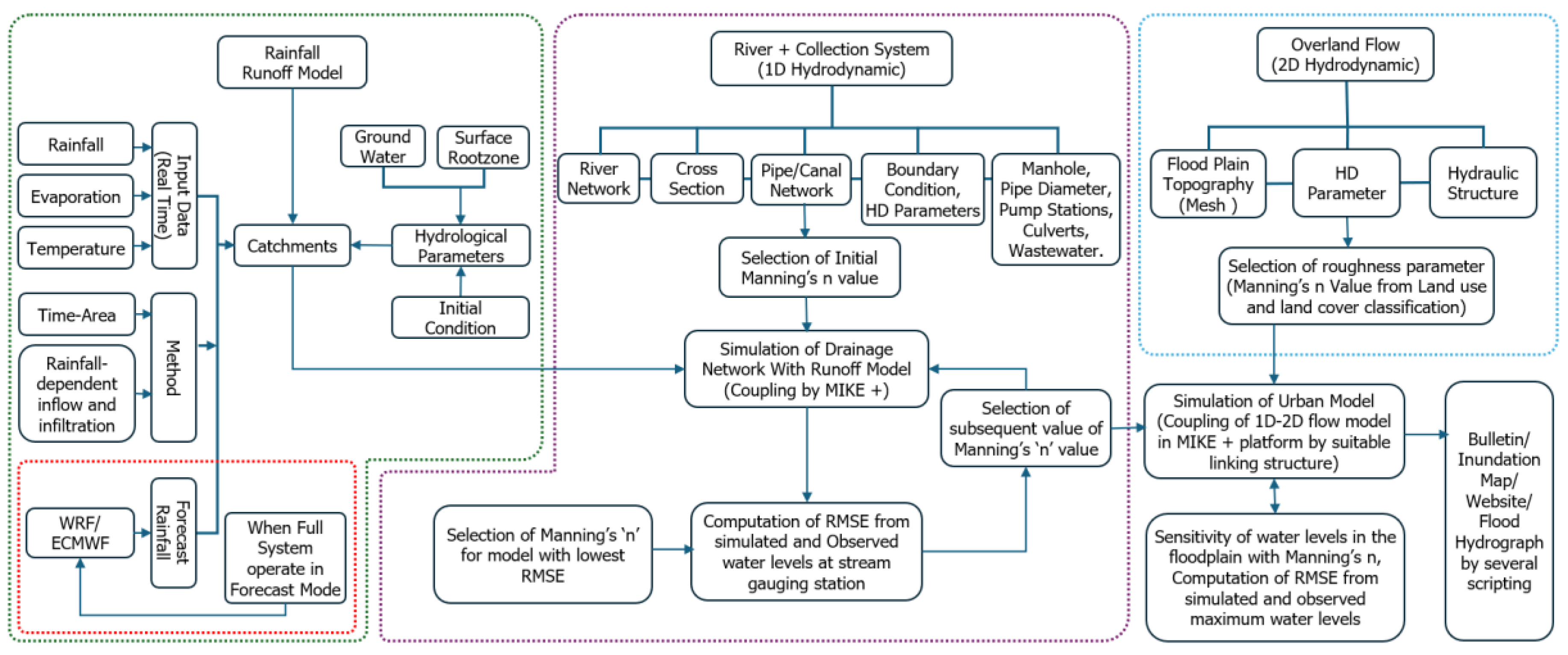
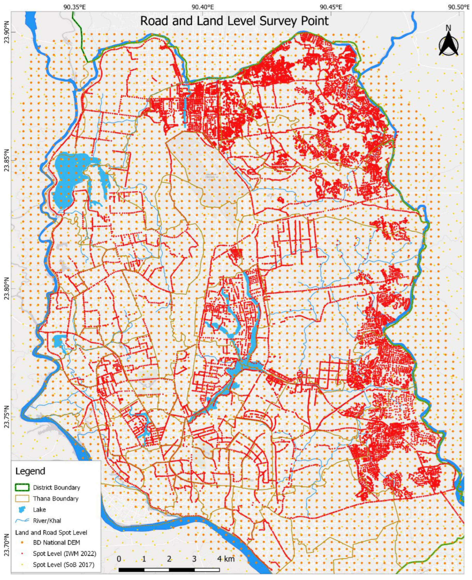
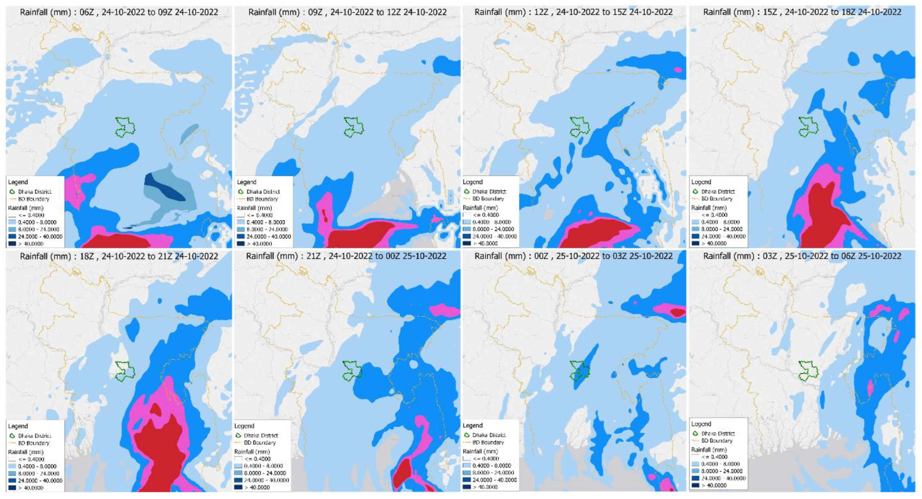
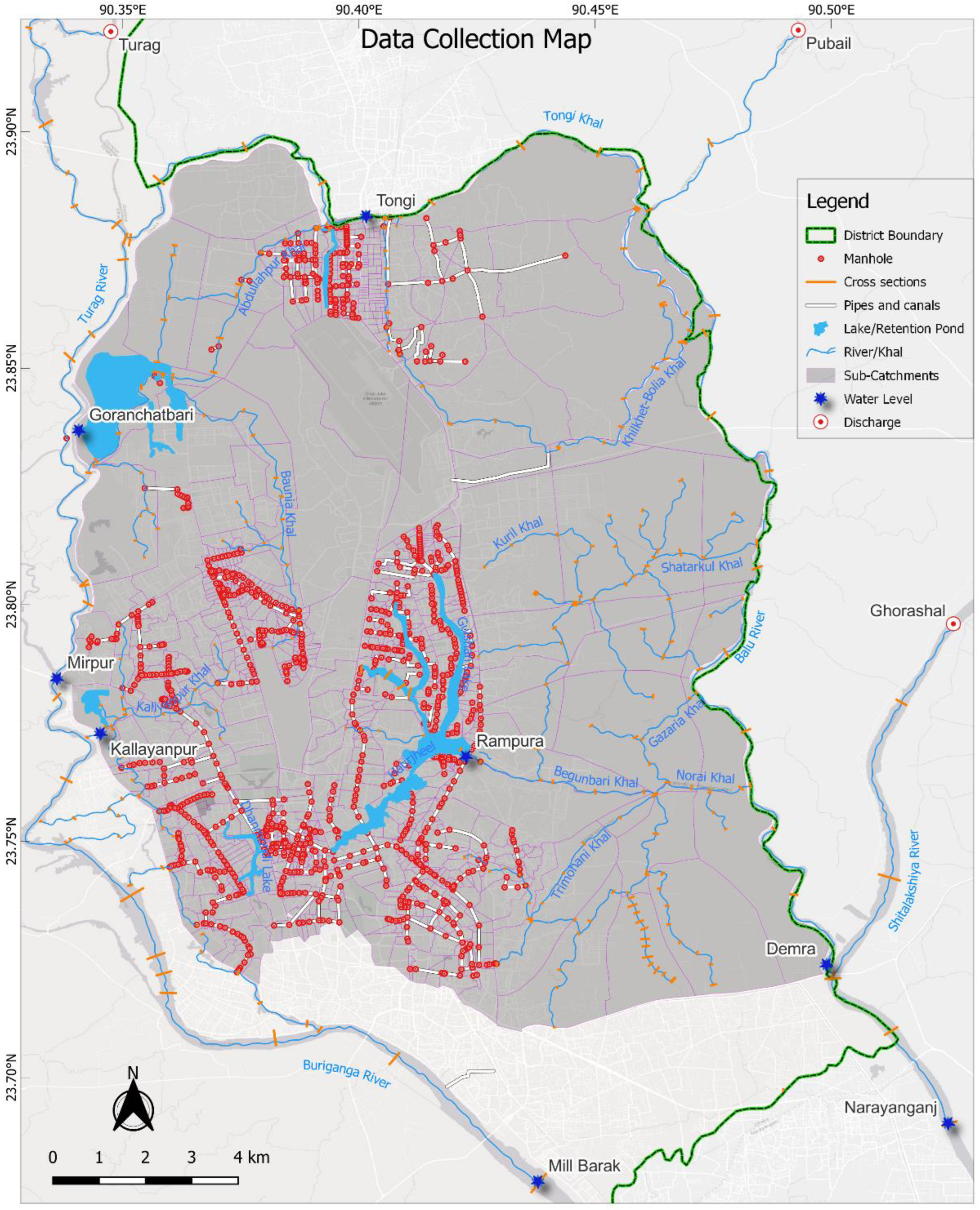
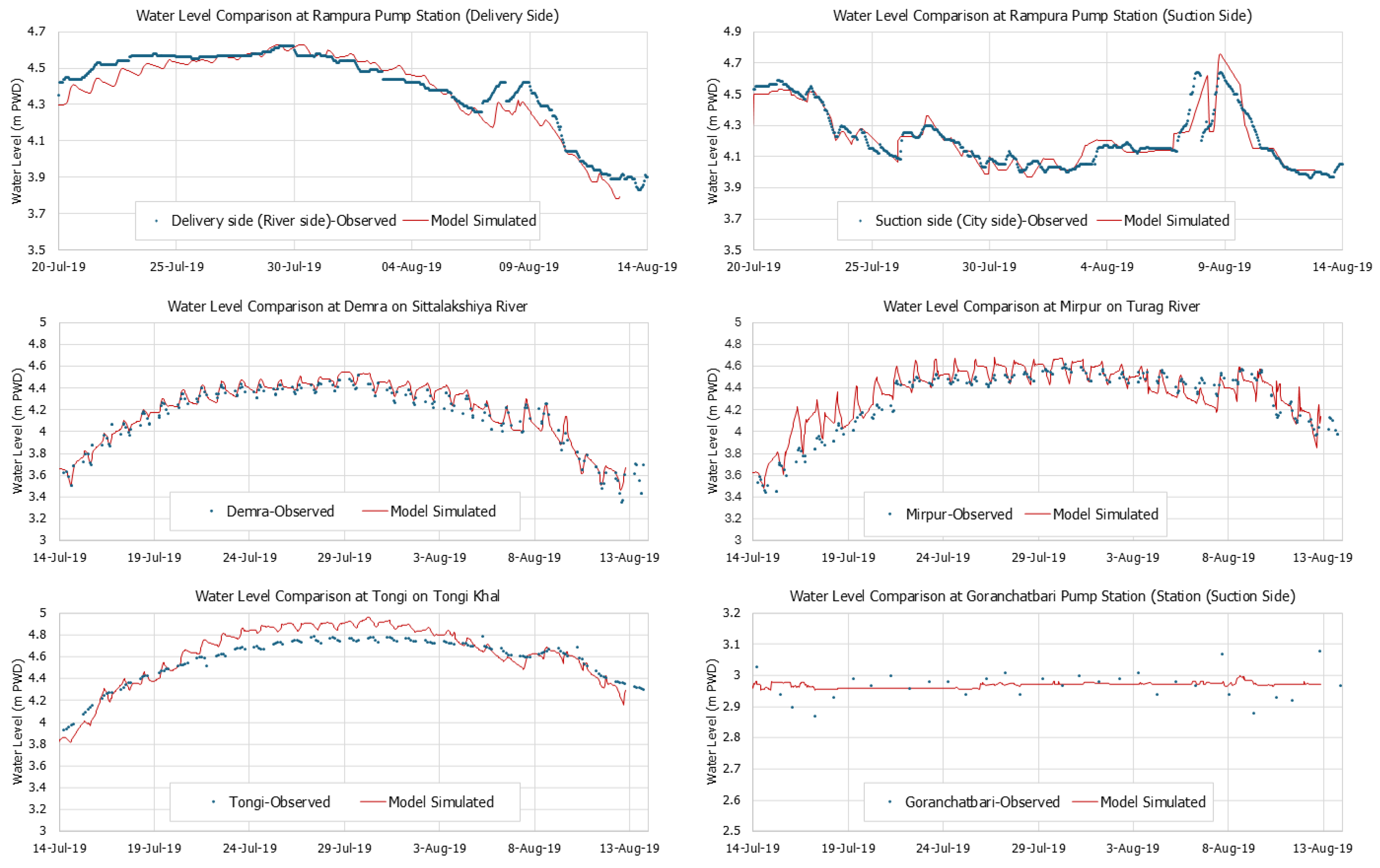
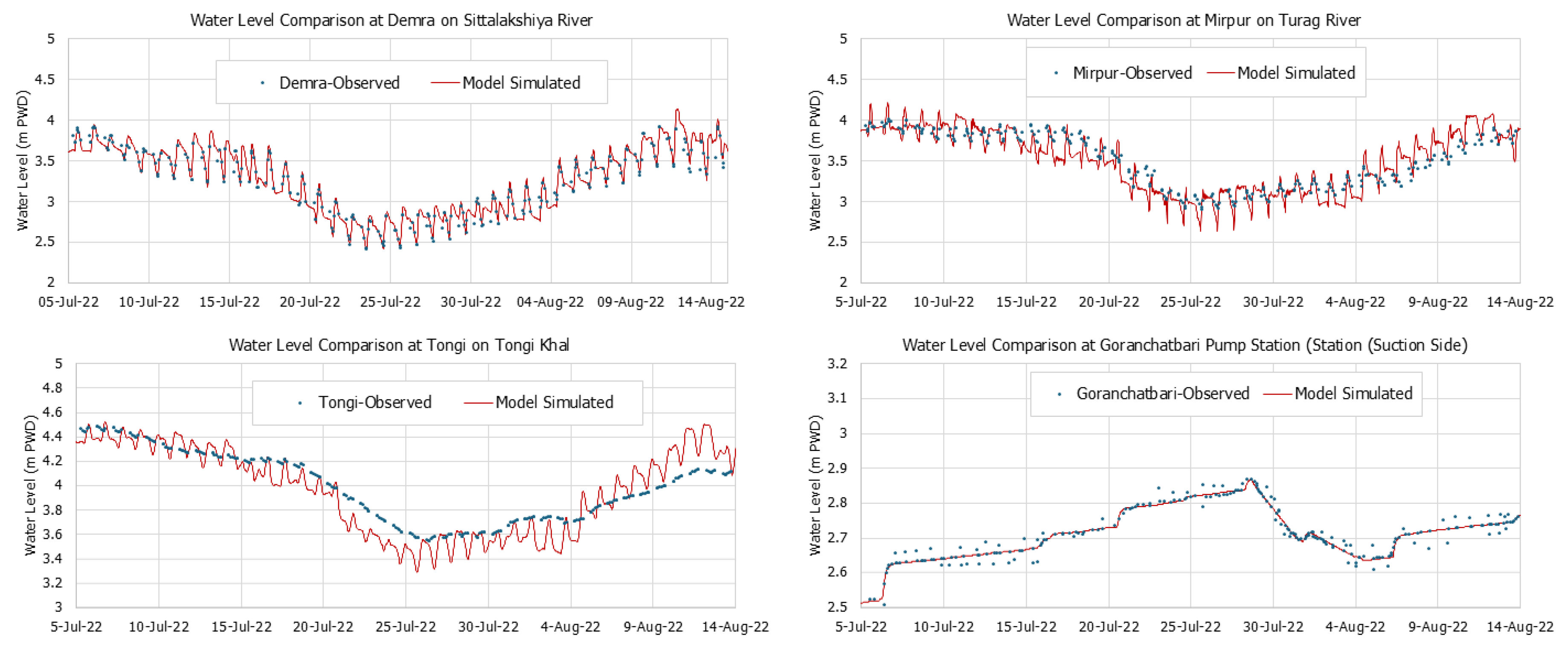
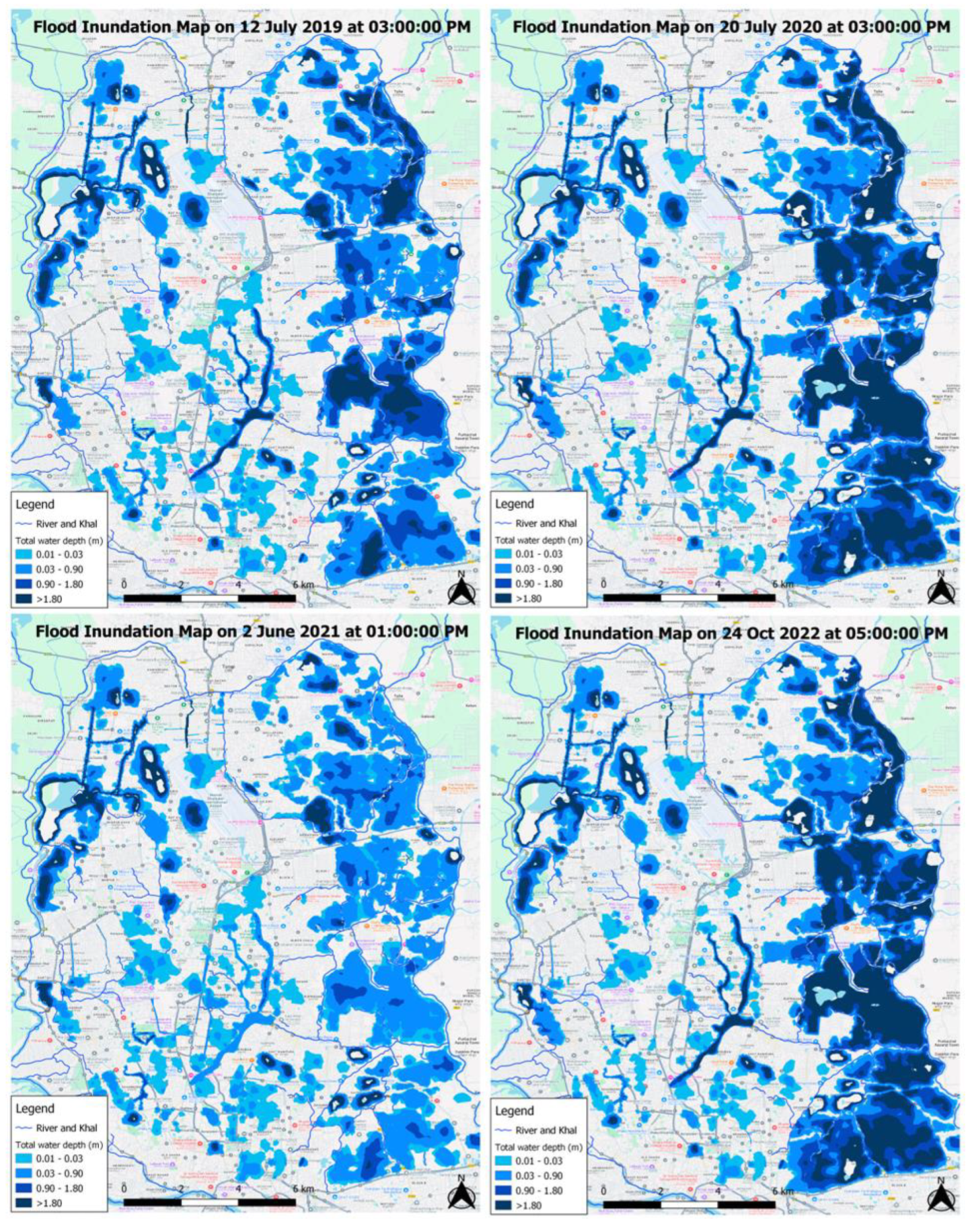
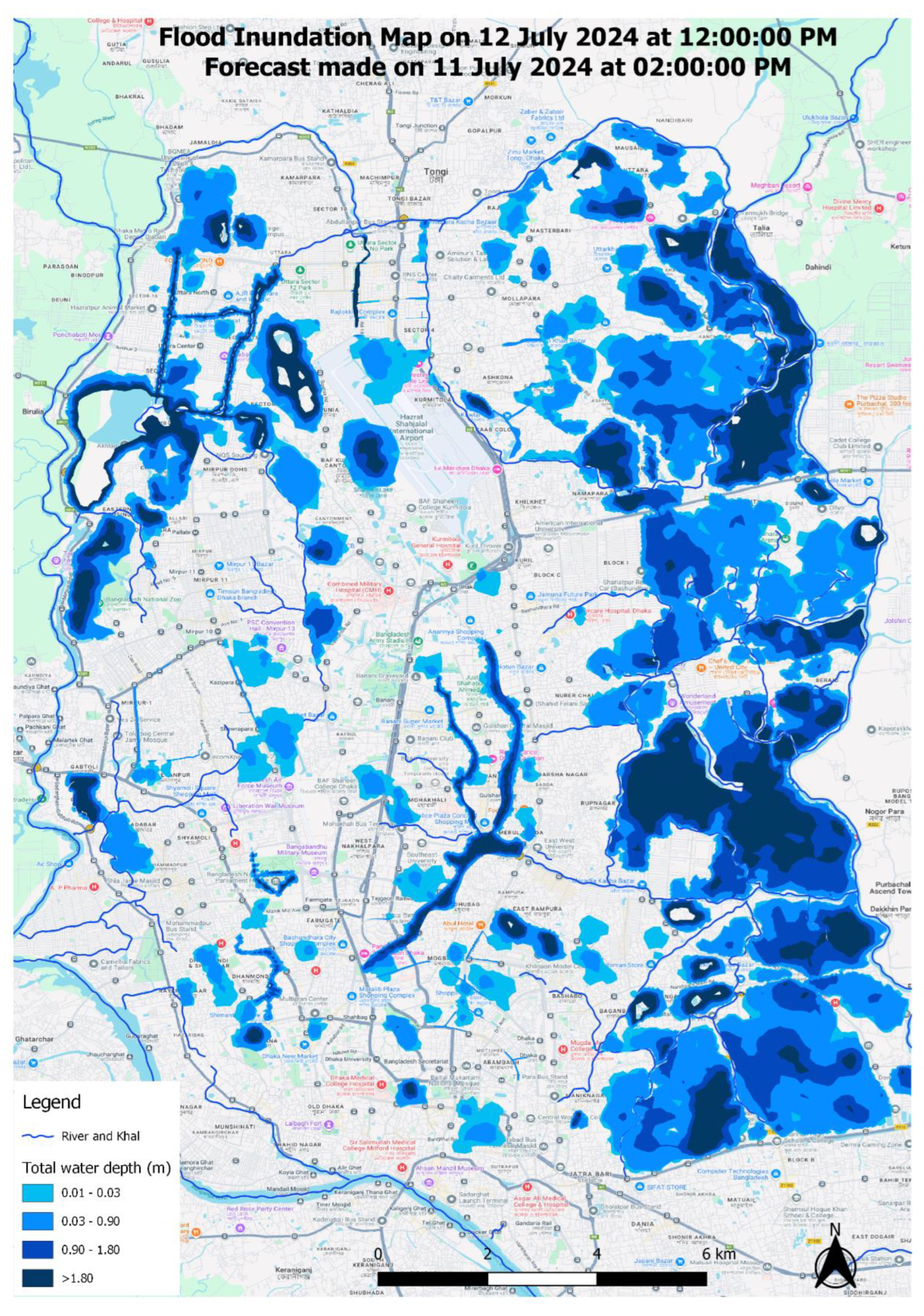

| Station Name | Type | River/Location | Used for | Source |
|---|---|---|---|---|
| Balu | Q | Pubail | UP Boundary | http://www.ffwc.gov.bd/ |
| Shitalakshiya | Q | Shitalakshiya | UP Boundary | http://www.ffwc.gov.bd/ |
| Saitskandi | Q | Turag | UP Boundary | http://www.ffwc.gov.bd/ |
| Tongi | WL | Tongi khal | Calibration | http://hims.bwdb.gov.bd/hydrology |
| Demra | WL | Balu | Calibration | http://hims.bwdb.gov.bd/hydrology |
| Rampura | WL | Hatitjheel (both city and river side) | Calibration | https://dwasa.org.bd |
| Goranchatbari | WL | Goranchatbari (both city and river side) | Calibration | http://hims.bwdb.gov.bd/hydrology |
| Mill barak | WL | Buriganga | DS Boundary | http://hims.bwdb.gov.bd/hydrology |
| Narayanganj | WL | Shitalakshiya | DS Boundary | http://hims.bwdb.gov.bd/hydrology |
| Mirpur | WL | Turag | Calibration | http://hims.bwdb.gov.bd/hydrology |
| Sl | Name Of Khal | Length (M) | No Of X-Section | Remarks |
|---|---|---|---|---|
| 1 | Balu River | 3150 | 11 | IWM-2018 |
| 2 | Buriganga | 17000 | 7 | IWM-2016 |
| 3 | Gulshan Lake | 3985 | 7 | IWM-2017 |
| 4 | Joaira_Khal | 4000 | 10 | IWM-2018 |
| 5 | Khilgaon-Basabo_Khal | 3000 | 15 | DWASA-2007 |
| 6 | Shitalakshiya | 4500 | 19 | BWDB-2001 |
| 7 | Shitalakshiya | 25000 | 37 | IWM-2018 |
| 8 | Senotikhal | 5650 | 9 | IWM-2016 |
| 9 | Tongi Khal | 16200 | 11 | IWM-2018 |
| 10 | Turag | XX | 30 | IWM-2018 |
| 11 | Wapda_Khal | 2360 | 13 | IWM-2016 |
| 12 | Canal | 120254 | 174 | IWM-2022 |
| Indices | Unit | Rampura (Suction Side) |
Rampura (Delivery Side) |
Demra | Mirpur | Tongi | Goranchat Bari (Suction Side) |
|---|---|---|---|---|---|---|---|
| ME | [m] | 0.09 | 0.04 | -0.03 | -0.05 | -0.04 | 0.00 |
| MAE | [m] | 0.10 | 0.06 | 0.05 | 0.10 | 0.09 | 0.04 |
| R^2 | [-] | 0.69 | 0.97 | 0.96 | 0.84 | 0.92 | 0.80 |
| NSE | [-] | 0.79 | 0.93 | 0.94 | 0.81 | 0.73 | 0.85 |
| IA | [-] | 0.83 | 0.98 | 0.99 | 0.94 | 0.95 | 0.21 |
| Indices | Unit | Rampura (Suction Side) |
Rampura (Delivery Side) |
Demra | Mirpur | Tongi | Goranchat Bari (Suction Side) |
|---|---|---|---|---|---|---|---|
| ME | [m] | 0.07 | 0.08 | -0.05 | -0.03 | -0.07 | 0.04 |
| MAE | [m] | 0.09 | 0.07 | 0.07 | 0.09 | 0.10 | 0.07 |
| R^2 | [-] | 0.66 | 0.93 | 0.93 | 0.80 | 0.90 | 0.75 |
| NSE | [-] | 0.63 | 0.90 | 0.92 | 0.85 | 0.70 | 0.78 |
| IA | [-] | 0.81 | 0.89 | 0.91 | 0.90 | 0.92 | 0.25 |
| Flood Event | Inundated location by model simulation | Verification By |
|---|---|---|
| 12-Jul-2019 | Dhanmondi, Kalyanpur, Shantinagar, Rajabazar, Rampura, Badda, Mirpur, Moghbazar, Uttara | Newspaper and Consultation with local people |
| 20-Jul-2020 | Mouchak, Malibagh, Shantinagar,Moghbazar, Kakrail, Paltan, Dainik Bangla Intersection, Khilgaon Rail Gate, and Rajarbagh Police Lines | Newspaper and Consultation with local people |
| 02-Jun-2021 | Mohakhali, Nakhalpara, Tejgaon, Banani, Chairmanbari, Kazipara, and Shewrapara | Newspaper and Consultation with local people |
| 24-Oct-2022 | Uttara, Moghbazar, Adabor, Mohakhali, Kawla, Mirpur | Field Survey by IWM |
| Area | Road | Importance location | 23-Oct-22 | 11-Jul-24 | ||
|---|---|---|---|---|---|---|
| WD (cm) | Alarm | WD (cm) | Alarm | |||
| Mirpur | Darus Salam Road | Govt Staff Quater | 30 | Hit | 27 | Hit |
| Mirpur | Darus Salam Road | Govt Bangla College | 5 | Hit | 3 | Hit |
| Mirpur | Darus Salam Road | BIHS Hospital | Miss | Miss | ||
| Mirpur | Dhaka Aricha Road | Mohona Filling Station | 5 | Hit | Miss | |
| Uttara | Shayestakhan Ave | Uttara Sector 02 | 67 | Hit | 54 | Hit |
| Uttara | Road 05 | Uttara Sector 04 | 33 | Hit | 23 | Hit |
| Uttara | Road 13 | Uttara Sector 4 | 4 | Hit | 3 | Miss |
| Kawla | Kawla RD | Kawla | 8 | Hit | 6 | Hit |
| Mogbazar | Moghbazar Road | PWD Staff Quater | 23 | Hit | 28 | Hit |
| Mohakhali | Mymensing Road | Mohakhali Bus Terminal | 45 | Hit | 50 | Hit |
| Mogbazar | Outer Circular Road | Moghbazar Convention Cent | Miss | 6 | Hit | |
| Mogbazar | Outer Circular Road | Dr Sirajul Islam Medical | 4 | Hit | 7 | Miss |
| Adabor | Road-13 | Uday Housing | 23 | Hit | 17 | Hit |
| Mirpur | Darus Salam Road | Govt Staff Quater | 30 | Hit | 25 | Hit |
| *WD= Water Depth, Miss= Model couldn't capture the flood scenarios | ||||||
Disclaimer/Publisher’s Note: The statements, opinions and data contained in all publications are solely those of the individual author(s) and contributor(s) and not of MDPI and/or the editor(s). MDPI and/or the editor(s) disclaim responsibility for any injury to people or property resulting from any ideas, methods, instructions or products referred to in the content. |
© 2024 by the authors. Licensee MDPI, Basel, Switzerland. This article is an open access article distributed under the terms and conditions of the Creative Commons Attribution (CC BY) license (http://creativecommons.org/licenses/by/4.0/).