
Submitted:
26 July 2024
Posted:
26 July 2024
You are already at the latest version
Abstract
This study describes the relationship between the epikarst and the surface karst of climatic karsts. Bedrock resistivity values along VES measurements were measured and calculated. The elevation difference between the surface and the karstwater table and the annual distribution of precipitation were calculated in certain karst areas. The resistivity of the epikarst can be high (drawdown dolines) and low (subsidence dolines). In the former case, the cavity index and the vertical drainage of the epikarst are heterogeneous, while in the latter they are homogeneous. Considering the above characteristics, two types of doline development are possible. A feature development controlled by the epikarst (tajga karst, soil-covered karst of the temperate belt, glaciokarst), by the epikarst and the karstwater (polje karst, fengcong karst), and controlled predominantly by karstwater (intermountain plain of fenglin karst, tropical karren). At feature development controlled by the epikarst, drawdown dolines (soil-covered karst) and subsidence dolines (covered karst) develop, in the case of feature development controlled by the epikarst and karstwater, drawdown dolines, subsidence dolines and feature assemblages with subsidence dolines and katavotra (polje karst, fengcong karst) are formed. At feature development controlled predominantly by karstwater, subsidence dolines (intermountain plain of fenglin karst), and giant grikes (tropical karren) develop.
Keywords:
resistivity
; VES measurement
; climatic karst type
; drawdown doline
; subsidence doline
1. Introduction
In this study, the characteristics of the epikarst, the role of these characteristics, the effect of its presence or lack on surface feature development and by this, its impact on the landscape of different karst types is investigated on different climatic karst types.
Epikarst is the upper, surface, karren, or subsurface part of the karst with cavities [1,2,3,4,5,6], where secondary porosity may reach 10-20 % [7]. Some of its characteristics are shown in Figure 1. The infiltrating water is stored in the cavities (these develop along the bedding planes and fractures below karren) of the epikarst. At its saturation level, which is the lower surface of the epikarst, infiltration decreases because the cavity formation is of low degree below this level (1-2 %). The water swells back thus, it creates the piezometric surface [1,5], below which there is permanent water fill in the epikarst. The piezometric level may fluctuate depending on the degree of water supply or it may be permanently modified (for example due to the increase of the degree of cavity formation). Its thickness ranges from 10 m to 30 m [6,7,8]. Recent epikarst, paleoepikarst [7], and incipient epikarst [9] are distinguished.
The karren-free part of the epikarst with cavities and the karstwater may develop variously relative to each other and to the surface. The wet part of the epikarst may occur close to the bedrock surface or at a deeper position [10]. The karstwater, particularly if its level is increased significantly, may occupy the epikarst temporarily (katavotra), or permanently for example below glaciers [11,12,13]. At other sites, the epikarst does not develop at all, in spite of the fact that the karstwater table is deep below the surface. According to Williams [7], at sites where the rock is of high primary porosity (20-45 %) instead of horizontal water motion, the vertical is predominant. However, it also occurs that no epikarst develops in the case of lower primary porosity either. On the pseudotectonic grike walls, on the Eocene limestone of Mount Bocskor in the Bakony Region (Hungary), [14] there are no solution cavities and karren are absent on the rock surface. The cavities of the epikarst may open up for example by glacial erosion [7], or the epikarst may become inactive (because no water with dissolution capacity reaches it).
In our studied areas, the VES measurements penetrated into a depth of 3-20 m in the bedrock. Since the epikarst is at this depth, the resistivity values of this depth interval provide information on the characteristics of the epikarst such as on the degree of cavity formation in the epikarst, or the position and the pattern of the piezometric surface.
There is a strong relationship between the climate and the size, density and diversity of surface karst features: the above parameters of karst features are increasing towards the Equator since the duration of precipitation, the amount of precipitation (except the dry, desert areas) and the temperature are also increasing in this direction [15]. In this study, the terms used for the studied climatic karst types are based on the nomenclature of Jakucs [16], Ford and Williams [17], Veress and Vetési-Foith [15]: taiga karst, the karsts of areas of middle latitude (with cool summer, then with hot summers in eastern direction), Mediterranean and subtropical karst, tropical rainforest karst, tropical savanna karst, tropical monsoon karst and glaciokarst.
Some karst features occur on all climatic karst types (karren, dolines), while others only occur on some types (poljes, inselberg karst and its feature assemblages, tropical karren). Based on their size, karren may be microkarren, mesokarren, and megakarren [18]. Mesokarren, particularly their karren of flow origin (rinnenkarren) may be significant water suppliers of the epikarst. Tropical karren consist of remnant features (pinnacles) and grikes with an expansion of several tens of meters. Its varieties are tsingy (Madagascar), stone forest (China), a pinnacle karst (Sarawak), and pinnacle-arête karst (New-Guinea) and in Australia, the tropical monsoon karst [19,20,21,22,23,24,25].
Solution dolines develop on soil-covered karst, subsidence dolines are formed on covered karst (thus, their development not only climate-dependent, but it also depends on the presence of the caprock). Among solution dolines, drawdown dolines develop at those sites of the epikarst where water drainage is increased (Figure 2), point recharge dolines are formed at the increased infiltrations of valley floors and inception dolines develop at the impermeable beds intercalated into the rock [7,17,26]. Subsidence dolines are formed by collapse (dropout doline), by suffosion (suffosion doline), by compaction (compaction doline) and by sagging of the cover, sagging sinkholes develop [27,28,29,30].
Poljes are widespread on Mediterranean and subtropical karsts, but they also occur on glaciokarsts [31,32,33]. They can be classified based on their morphology, genetics and hydrology [6,17,31,32,33].
Inselberg karst develop in tropical areas (under tropical rainforest climate, tropical savanna climate and tropical monsoon climate). Its varieties are fengcong, where there are mountains with a common base, with depressions between the mounts and the fenglin, where the mounts are solitary surrounded by intermountain plains (with subsidence dolines on them) [23,31,34,35,36,37]. The varieties of fengcong are the polygonal karst, cockpit karst, but according to the altitudinal occurrence of fengcong, several varieties are also distinguished [23,36].
On glaciokarsts, the features of glacial erosion and the karstic landscape are mixed and develop partially on each other. Due to the vertical zonality of the climate, the appearance of the features is also zonal. At lower altitudes, active drawdown dolines occur, while at higher elevations, there are drawdown paleodolines and schachtdolines [13]. Since the caprock is limestone debris, saturation may already take place in it [31,38] and thus, the epikarst is not active at such sites. Subsidence dolines, karren and shafts are widespread.
In the development of some karst features, only the epikarst plays a role for example in the case of drawdown dolines [7,28]), while in the development of other features the epikarst and the karstwater have a mutual effect (poljes). However, other karst features may also be formed, in the development of which, the karstwater has an important role for example in the case of Bemaraha Tsingy [25], tropical monsoon karst [20,21], or fenglin [37], and the role of the epikarst is subordinate or does not exist at all.
2. Measurement areas (Figure 3)
Aggtelek Karst (Hungary) is mantled mountains built up of Triassic gypsum-anhydrite and carbonate rocks [39]. It is separated into plateaus by epigenetic valleys, in which, but also on the surfaces between the valleys, several drawdown dolines can be found [40]. The profile of the VES measurement was made through two dolines of a drawdown doline row of an epigenetic valley.
The Bakony Region (Hungary) is a part of the Transdanubian Mountains, which is situated in a northern direction from Lake Balaton. The mountains are built up of blocks, which are mainly constituted by Triassic dolomite, on which Dachstein Jurassic, Cretaceous, and Eocene limestone patches occur in smaller expansion. Its surface is covered by clayey gravel and loess and their reworked, mixed varieties in widespread distribution [39]. The drawdown dolines are paleo features, but subsidence dolines are widespread [40]. The profiles, along which the measurements were made, went through subsidence dolines as well. Such measurements were made on an epigenetic valley floor on Tés Plateau, at the Eleven-Förtés doline group (which is borne by a larger, partly filled drawdown doline) in the area of Mester-Hajag North (here in an area between limestone mounds), at the margin of Fehérkő Valley (on a terrain between mounds) and a doline group of Homód Valley (floor of epigenetic valley).
The central part of the Bükk Mountains (Hungary) is a plateau, which is mostly built up of Triassic mantles [39]. Drawdown dolines are widespread on valley floors and on mounds too [40]. The VES measurements were made in a doline with flat floor of Zsidó-rét (Great Plateau).
The Labija Valley is a tributary valley of River Lena (Yakutia, Russia) with intermittent stream. The environs of the Lena is built up of Cambrian and Silurian limestones and dolomites [41], its environs are covered by sand and clay on the interfluves. On the cover, subsidence dolines also occur. The Labija Valley is wide, plate-shaped or of plain floor. Its eastern slope is dissected by pillars. Solution dolines (drawdown dolines) are aligned in the channel of the valley floor. The area is of subarctic climate thus, permafrost is widespread.
Padis Plateau is part of the Bihar Mountains (Romania). The plateau is built up of Triassic and Jurassic limestones [42]. Here, large drawdown dolines are widespread, but on its covered karst patches (some of them are in drawdown dolines) several subsidence dolines also occur. The material of the cover is sandstone debris, which accumulated during fluvial transportation. The VES profiles were made in the area of a large (with a diameter of about 400 m), old depression with flat floor (Rǎchite) and on the floor of an epigenetic valley. On both measurements sites, there are many subsidence dolines, but in the area of Rǎchite, depressions are also widespread on the bedrock.
The Western Mecsek Karst (Hungary) is built up of Middle Triassic limestone, which is covered by loess in continuous development and its sandy, clayey varieties. Its karst features are the drawdown dolines which constitute rows and subsidence dolines. The subsidence dolines occur in drawdown dolines, but also outside them. On the karst, the doline density is high, it may also reach 80 dolines/km2 [43]. Some VES profiles were made in drawdown dolines, while others outside them. The latter profiles crossed subsidence dolines.
Totes Gebirge, Dachstein and Hochschwab are parts of the Northern Limestone Alps and structurally the surviving parts of the Upper Austroalpine Nappe [44,45,46]. The large depressions of glaciokarst areas are paleodolines [13] in which moraine of limestone material and cover of frost weathering origin can be found. Several small subsidence dolines may have developed on this. The VES measurements were made in paleodolines, which also crossed subsidence dolines.
During the study of inselberg karst, the data of Chinese tropical karsts were taken into consideration based on literary data.
When studying tropical karren, the data of Bemaraha Tsingy, the Australian monsoon karst and one of the Tanzanian Karsts (Tanga Karst) were used [20,21,25,47].
Bemaraha Tsingy (Madagascar) is separated into Great Tsingy and Little Tsingy, the latter is cut through by River Manambolo. It developed on Jurassic limestones. Blocks, large grikes and pinnacles are predominant on the tsingy [25]. According to Salomon [48], the primary porosity of the bearing rock is 1-2 %.
Grimes [49] claims that North Australian tropical karren are characterized by the low altitude of their surface, low primary porosity, tropical monsoon climate and they are densely packed with fractures. These karsts are large grikes, where features of karstwater origin occur on the grike walls and the grikes are connected to caves that developed below the karstwater table.
Several grikes occur on Tanga Karst (Tanzania), which developed on Jurassic limestone (here, the rock is also of low porosity) and it is karst close to the coast. On the walls of grikes there are bedding-planes caves. The grikes were connected with karstwater caves by collapses [47].
3. Methods
The distribution of drawdown dolines was mapped in a permafrost area in the valley of one of the tributary rivers of River Lena. The sites of VES measurements (see below) were also mapped.
VES measurements were carried out in active drawdown dolines on the karsts of Răchite, Aggtelek Karst, Bükk Mountains, and the Western Mecsek and in the paleodolines (inactive drawdown dolines) of glaciokarsts by the colleagues of the Terratest Ltd. VES measurements were also made along profiles crossing subsidence dolines on covered karsts (Bakony Region, Western Mecsek Karst, Pádis). However, since the subsidence dolines are of small size, mostly only some VES measurements were made and only some sites were suitable for more measurements (at most three). Geoelectric-geological profiles were prepared with the use of the measurement data. The theory of VES measurement can be read in the work by Veress [50].
The average resistivity of the bedrock below the drawdown dolines of various karst areas was calculated. The pattern of resistivity was analysed below the drawdown dolines in horizontal and vertical directions. Thus, the average resistivity values were calculated in the centre and marginal parts of the dolines in Western Mecsek Karst.
Average resistivity values were calculated in the dolines and of their environs in the case of the subsidence dolines of five sample sites in the Bakony Region. The quantity of water getting into the karst in these areas was estimated and calculated. The average resistivity below thirty subsidence dolines was also compared with the average resistivity of the bearing profiles of the dolines, here. Taking into consideration the estimated water quantity of the studied areas and the relation between the resistivities below the dolines and the average resistivities of their environments, doline groups were made.
The average resistivity values being calculated at depressions with drawdown dolines were compared with the averages of the resistivity of covered karsts (with subsidence dolines). In the area of Răchite, Padis where the terrain with drawdown dolines was also covered, average resistivity values measured at the plain bedrock and at the bedrock with mounds were compared.
The relationship between the resistivity values of the cover and the bedrock below the small subsidence dolines of glaciokarsts was analysed.
The relationship between hydrology and karstification was studied in poljes and on inselberg karsts with the use of literary data.
On tropical karren with large grikes (Bemaraha Tsingy, Tanga karst, Australian monsoon karst), the position of the karstwater table relative to the karst surface, and the annual distribution of precipitation was also studied in this area.
4. Results
Based on the mapping of the Labija Valley, drawdown dolines are small and are aligned on the channel floor and in its environs (Figure 4).
1. drawdown doline, 2. intermittent stream of channel
The resistivity values of the bedrock are varied and different at the places of VES measurements. Below the drawdown doline floors of the temperate belt, either covered by soil or superficial deposit, the resistivity values are high (they exceed 5000 Ohmm). Below the paleodolines of glaciokarsts, resistivity values above 5000 Ohmm, but below this value also occur (Table 1). At the subsidence dolines of covered karsts and in their environs, the resistivity values are lower (they are below 5000 Ohmm, Table 2). Extremely low resistivity values occur at the subsidence dolines of the Bakony Region [10], or at the subsidence dolines of the paleodolines of glaciokarsts, but the resistivity values are higher at the subsidence dolines of the covered karst of Padis. Based on the resistivity values of the Bakony Region, the sample sites can be put into two groups. A group involves those with extremely low resistivity (the average resistivity is some 100 Ohmm, such as at the subsidence dolines of Tés Plateau, the Eleven-Förtés doline group and Homód-valley), their epikarst receives more water, and the surface is more karstified, here. The average resistivity exceeds 1000 Ohmm at those belonging to the other group (Mester-Hajag North, the margin of Fehérkő Valley). The epikarst of these areas receives less water and their surface is less karstified [10], Table 2).
The resistivity values below drawdown dolines may be decreasing, the same, or irregularly changing from the doline centre towards the margins. The decrease is particularly well represented by the inner and marginal average resistivity values of dolines in the area of the Western Mecsek Karst (Figure 5, Table 1). (However, it may occur in some cases when resistivity is lower below the doline centre which can probably be explained by the fact that the cavities above the piezometric level are filled.) The resistivity values may decrease towards the margins even if the doline is infilled and covered (Padis, Figure 6). However, subordinately in some cases the resistivity is lower below the centre of the doline, which may presumably be explained by the fill of the cavities above the piezometric level. On glaciokarsts (Dachstein), the resistivity of the bedrock may also change vertically. Here, the resistivity values of the cover between the dolines exceed the resistivity values of the cover below the small subsidence dolines of glaciokarsts. Below subsidence dolines and in the bedrock of their environment, the resistivity values are not only low, but the resistivity values below the dolines in the bedrock and the differences of the resistivity values of their environment are also low. The resistivity values are low in the bedrock below the dolines in absolute sense as well (Figure 7). However, on glaciokarsts, in the area of the main depression of the bedrock or at a smaller bedrock depression within this, the decrease of the resistivity towards the margins cannot be experienced, their distribution is irregular (Figure 8).
In the area of the larger depression bearing the Eleven-Förtés doline group, where there are infilled and buried depressions on the bedrock, the resistivity values are not decreasing towards to margins (Figure 9, Figure 10).
Drawdown dolines, the bedrock of which is flat-floored (Figure 11) [51], or of uvala-like pattern (Figure 12) also occur, but at them, the resistivity values are the same or if they are not, they slightly change.
In the Bakony Region, the resistivity values below subsidence dolines (there is no depression on the bedrock at these features) were compared with the resistivity values of the bearing profile. The average resistivity below 12 dolines out of 30 studied dolines was higher, and in 11 cases it was lower than the average of the resistivity values measured along the bearing profiles. There was a shaft on the floor of seven dolines, where no VES measurements were possible to be made (Table 3, Table 4). Both among dolines with bedrock resistivity values higher or lower than their environment, there are dolines which are in areas richer in water and poorer in water (Table 4). While the superficial deposit was of suffosion structure in the case of the above dolines, the subsidence dolines above the infilled drawdown dolines of Padis developed by the deflection of the cover beds.
The katavotra of Cirknitz polje were studied in a detailed way. It can be established that here, the high karstwater table reaches some part of the polje floor. (There is a depression on the cover, but there is no depression on the bedrock.) Katavotra constitute a passage group, around them various karren occur (Figure 13), but there are also subsidence dolines here. Farther, the polje floor has permanently drier parts (dry polje part), and at other parts there is a lake (permanently wet polje part).
There is dissected epikarst in the area of fengcong karst. The drawdown dolines with different depth approach the karstwater table to a different degree. In some dolines, even low karstwater table may appear [23], while the floor of other dolines is above the high karstwater table [17,34,35,52]. The appearance of the karstwater in the depressions indicates that the epikarst is not everywhere and not always present at poljes and at the drawdown dolines of fengcong. At sites, where it is present, it is of different elevation. It is of higher elevation on plateaus and on inselbergs (fengcong), and of lower elevation in the poljes and drawdown dolines.
Subsidence dolines develop in large numbers on weathering residue and fluvial stream load, on the intermountain plains of fenglin karst [29,53]. The karstwater table is at the bedrock of the intermountain plain [34,37]. Since due to water pumping, the frequency of subsidence doline development increases [53,54,55], there is a close relationship between the natural or artificial subsidence of the karstwater table and doline development. This refers to at least a temporary lack of the epikarst in the area of intermountain plains.
Some tropical karren areas were selected where features that developed below the former karstwater table in the side of grikes can be found [20,21,25,47]. At these karren, the karswater table was above the grike floors for a shorter and longer duration. The closeness of the karstwater table to the grike floors is indicated by the fact that a basin with permanent water occurs on Bemaraha Little Tsingy, the level of which fluctuates during the flood events of River Manambolo [25]. The former or current presence of the karstwater also refer to the temporary presence of the epikarst.
In the studied karren areas, the elevation difference between the karst surface and the karstwater table never exceeds 100 m and the minimum difference is larger than 50 m only in two cases (Table 4). The elevation differences would be even lower than the values included in the table if we regarded the elevation difference between the grike floors and the karstwater table. The features of the grike walls that developed below the karstwater table refer to the former or current more elevated level of the karstwater table [25].
On these tropical karren, the amount of precipitation is varied, but its annual distribution is extremely uneven (Table 5, Table 4). The precipitation amount of the wettest months only makes up 20-30 % of the annual amount of precipitation with the exception of one case (this is Tanga Karst, where the values of precipitation amounts are high in every month). Grimes [20] emphasizes that in the case of the North Australian tropical karren, the majority of precipitation falls during intensive, short thunderstorms or during rains with a duration of several days. However, based on the data of Wikipedia, 1141 mm precipitation fell in January close to Broken River karsts (in the town of Townsville). Thus, in wet months there is a high chance of intensive rainfall. According to our calculations, at a grike with a width of 0.1 m, which may receive the water running down a surface part with a 5-5 m width, if the fractures occur in every 10 m, a water column with a height of 10.1 m develops in the grike in the case of 100 mm precipitation. Thus, the karstwater table may also become elevated at the grike floor in such a degree to the effect of the accumulated rainwater.
5. Discussion
Surface karstification may take place to the effect of the epikarst, the epikarst and the karstwater and predominantly of karstwater.
5.1. Karstification by epikarst
In an area, the value of resistivity depends on the degree of cavity formation in the epikarst (total cavity volume) and what proportion is filled with water or sediment (with wet sediment too) and on the thickness of the zone with cavities. The thinner the epikarst and/or to the less degree it contains cavities and the larger the water supply, the more elevation the piezometric surface and thus, the higher the chance for the VES measurements to penetrate below this surface and thus, the resistivity values are low. When the piezometric surface is of lower elevation because the epikarst is thicker and/or contains more cavities and the degree of water supply is low, the piezometric surface is at a deeper position and there is a lower chance for the VES measurements to reach the piezometric level thus, the resistivity values are high. The piezometric level may fluctuate, the cavities above its all-time level may become filled with sediment. Therefore, the resistivity values are also lower in the same depth if although the penetrations did not reach the piezometric level, the cavities above the level are filled.
On karsts of the temperate belt, the average resistivity values of terrains with a drawdown dolines are higher than those of covered karsts. This can be observed by the comparison of different karst areas (for example, the resistivity values of the covered karsts of the Bakony Region are lower than those of the karsts with drawdown dolines (Table 1, Table 2). The same fact can also be noticed in the case of the same karst area, in areas with drawdown dolines and covered karst areas adjacent to each other, thus, for example at the resistivity values of the areas with drawdown dolines and covered karst areas of the Western Mecsek Karst and Padis Karst (Table 1, Table 2). In the area of Răchite, there is covered karst with subsidence dolines above the drawdown dolines too. According to t-probe, there is a significant difference between the resistivity values of drawdown dolines and subsidence dolines. The significance is smaller at Western Mecsek (t0=0.13), and greater on Padis (t0=0.0000000043).
The resistivity values below the drawdown dolines are higher than at the subsidence dolines of covered karst terrains because below the drawdown dolines, the epikarst contains more cavities and the piezometric surface gets into a deeper and deeper position towards the doline centre (Figure 2) since the degree of water drainage is higher and higher in the above direction [60]. According to Gunn [61], the water drainage below drawdown dolines takes places through several channels, but Williams [7] states that it does not. The increase of the resistivity values towards the centre of the dolines proves the validity of this latter model. Due to the deeper position of the piezometric level, more and more cavities may occur above this level, which result in further resistivity increase if they are not filled.
The resistivity of the epikarst may change both horizontally and vertically even within a short distance. This takes place because the degree of cavity formation (and the degree to which the cavities are filled) is heterogeneous in the above directions. The degree of horizontal heterogeneous cavity formation may be local (linear) and regional (areal). The epikarst is local on permafrost, it is regional at poljes on soil-covered karsts of the temperate belt and on fengcong.
5.1.1. The degree of horizontally heterogeneous cavity formation of the epikarst below the drawdown dolines
As it has already been mentioned, resistivity values may change horizontally in a direction(s), it may be similar, or it may change irregularly or changing regularly, decreasing towards the margins. These characteristics refer to the characteristics of the degree of cavity formation of the epikarst. In the case of resistivity changing in a direction, the degree of cavity formation in the epikarst also changes. In the case of a similar resistivity, the degree of cavity formation is similar too, while in the case of resistivity values changing irregularly, the degree of cavity formation of the epikarst is also irregular in horizontal direction.
On permafrost (on taiga karst) the seeping waters of the valley channels melt the ground ice, where epikarst develops, which ensures drawdown doline development in the percolation zone (Figure 4). Similarly, linear epikarst is formed on the floor of epigenetic valleys since there is no epikarst below the impermeable cover in their environs [9]. However, in this case, the band of the epikarst and doline development may be widening during the denudation of the impermeable cover.
On soil-covered karsts of the temperate belt, on polje karsts and on fengcong karsts, the dolines are not necessarily aligned in rows (Figure 14), since infiltration is superficial. As the resistivity values below the drawdown dolines are not only high, but they are also increasing towards the doline centre, the piezometric surface is caved-in in a way that the vertical distance between this surface and the doline floor is increasing in the above direction.
The average resistivity values of the dolines of the Western Mecsek Karst prove the subsidence of the piezometric surface if the resistivity values of the centre and margin of the doline and the resistivity distributions below the dolines of the bedrock of Răchite are regarded (Figs. 5, 6). The cave-in of the piezometric surface may take place and thus, resistivity values may increase if the amount of biogenic CO2 increases at a place of the plain surface. The heterogeneity of CO2 production is determined by soil quality and soil thickness [16]. Below this place in the epikarst, the intensity of passage development and the rate of water drainage increases and by this the flow of surface water to this place also increases. The onward flow causes the accumulation of a larger amount of water and then a more intensive dissolution of the surface, which results in depression development [7]. The larger quantity of water further intensifies heterogeneous vertical water drainage and thus, the degree of horizontal, heterogeneous cavity formation.
During the operation of the above process system, in the case of active drawdown dolines, the piezometric surface and the saturation level may subside differently relative to each other. The subsidence may be of three kinds: they subside similarly, the piezometric surface subsides faster than the saturation level, or the piezometric surface subsides more slowly than the saturation level.
In the case of similar subsidence, the degree of cavity formation of the epikarst is homogeneous, the shape of the doline does not change, but its size does (Figure 15a).
The saturation level is subsiding faster than the piezometric surface because a larger quantity of water with higher dissolution capacity arrives at the drainage passage. (Such a situation can be seen in Figure3 of Williams’s study [60].) The dissolution is expanding vertically. If this state lasts permanently, the subsidence of the saturation level is accompanied by the subsidence of the piezometric surface due to the vertical expansion of cavity formation. The doline is deepening without widening. The degree of cavity formation in the epikarst is heterogeneous (Figs. 15b, 16a).
The piezometric surface is subsiding faster than the saturation level (Figure 15 c) because the degree of cavity formation increases in the environs of drainage in the epikarst since less water, but with better dissolution capacity arrives at the passage. The doline is widening. When the the piezometric surface reaches or approaches the saturation level in the total width of the doline (Figure 16b) the wet part of the epikarst decreases, the cavity formation above the piezometric surface is homogeneous (in this case there are high and the same resistivity values in the epikarst) and the rate of vertical water drainage is also homogeneous. In the case of the coincidence of the two levels, vertical material transport stops. First, this occurs at the main drainage site, then spreads towards the sites with less drainage thus, towards the margin of the doline. In the case of the coincidence of the two levels, dissolution on the floor is of the same or almost similar degree, which results in the development of flat or nearly flat floor. Similar resistivity values occur below some dolines whose floor is not plain (Figure 12) and at flat-floored (plate-shaped) dolines (Figure 11, [51]) too. Wide, flat-floored dolines (plate-shaped dolines) are always situated at the top of mounds in the Bükk Mountains [63]. This may be an indirect evidence for the above mentioned things because the roof level of mounds (and thus, the here occurring dolines) get less and less water since the development of mounds takes place during the denudation of their environment.
In the case of the paleodolines of glaciokarst, resistivity values do not decrease towards the margins. The diverse values of resistivities indicate that the heterogeneous cavity index of the epikarst during doline development has already stopped. A reason for this may be that the paleoepikarst may have been denuded to a various degree (at places where it has been denuded to a greater degree, the resistivity is lower because there are less cavities without water). Or if the paleoepikarst was completely denuded by glacial erosion and active epikarst may develop at sites where there is no limestone debris, or it is thin (the infiltrating water is not saturated yet when it arrives at the bedrock). At these sites, the piezometric surface may be more elevated and thus, the resistivity is lower. The degree to which the epikarst is filled significantly modifies the resistivity values of the bedrock below the paleodolines. The low bedrock resistivity values in Figure 7 show this. (In the profile the resistivities of the epikarst of a paleodoline of Dachstein can be seen.) Between the measurements sites D5 and D15 there is very low resistivity (average 538.83), doline density at the surface is large. Low resistivity can be explained by clayey beds below the debris. The material is probably transported into the epikarst from here, which then reduced its resistivity. The wash-in of the clay created a favourable condition to the suffosion of the cover debris and thus, to doline development. The resistivity which is higher below the dolines than in their environs (there are more airy hiatuses in the debris as a result of greater suffosion below dolines) also refers to this.
5.1.2. Vertically heterogeneous degree of cavity formation
The epikarst may also have a vertically heterogeneous degree of cavity formation if the epikarst is complex or it is developing more intensively locally or becomes filled up.
On glaciokarsts, the upper low resistivity values in the bedrock (Dachstein) refer to a low degree of cavity formation and thus, recent epikarst. Below this epikarst of upper position, there is a paleoepikarst of a deeper position, of higher degree of cavity formation and of higher resistivity (double epikarst).
The depression bearing the Eleven-Förtés doline group is an old feature (Figure 9), which fact is proved by the filled, inactive, and covered depressions of its bedrock (Figure 10). There are subsidence dolines on its fill. The resistivity values are low in their environment (Table 2) and these values are not increasing towards the centre of the depression. Therefore, there is double epikarst here, too. An epikarst of more elevated position, younger and active, which developed the inactivisation of the bearing depression, subsequently. The resistivity values of this epikarst were measured. Below this, an older, inactive epikarst with a lower position and filled with washed-in superficial deposit is situated.
5.1.3. Horizontal development of resistivity on covered karst
The resistivity values are low below subsidence dolines and in their environment. These low values can be explained by the elevated position of the piezometric level or by the fill of the cavities above this level [10].
The lower resistivity values of the bedrock below the subsidence dolines of the Bakony Region (groups A and B) can be explained by the piezometric level which is of an elevated position due to the larger quantity of water originating from an environment which is richer in water. Higher resistivity values are below subsidence dolines (groups C and D), where less water gets into the karst due to the lower water quantity of the bearing area by which the piezometric level is lower therefore, the resistivity is higher (Table 4). Both among the groups of dolines with low resistivity (group A), and high resistivity (group C) there are dolines below which the resistivity is higher than the average resistivity of their environment. These dolines are at the beginning of their development. More water arrives at the epikarst from the developing dolines, which increases local cavity formation below them above the piezometric level therefore, the resistivity increases locally. Below the dolines of groups B and D the resistivity relative to their environment decreases since the sediment being transported from the dolines by suffosion fills the cavities. According to our opinion, the dolines of group B are formed from the dolines of group A, while the dolines of group D develop from the dolines belonging to group C. Below the subsidence dolines, the piezometric surface is not subsided (perhaps at some of them to a low degree) since below 11 dolines, the resistivity values are higher than in the bedrock of their environment.
As the dolines belonging to group B are the largest and have a passage in the cover, the dolines of group E developed from them, these are the dolines with shafts. During shaft development, a sediment veneer is formed on the passages of the epikarst in a depth of some metres. At these sites, dissolution stops. Deeper than this site, where no veneer exists, it does not. Blind shafts develop from veneer-free passages which open onto the doline floor after their collapse [12]. The developing shaft separates the epikarst into parts.
5.2. Karstification by epikarst and karstwater
In the area of poljes or at the dolines of fencong, the epikarst and the karstwater may be in a varied position relative to each other, the piezometric surface and the karstwater table are not separated from each other in all cases. In poljes, where the elevation of elevated karstwater does not exceed the elevation of the bedrock, but there is cover, a polje part with subsidence dolines develops. At sites where it does, a polje part of subsidence dolines with katavotra develops, while at places where the cover is absent, but the elevated karstwater does not reach the bedrock surface, a polje part with drawdown dolines develops (Figure 17).
At those drawdown dolines of fengcong karst, where the floor is above the karstwater table, newer drawdown dolines are formed on the floor. If the elevation of the karstwater table exceeds the elevation of the floor, dolines with intermittent lakes develop. At sites where cover is present on the floor, if the bedrock surface is more elevated than the karstwater table, subsidence dolines are formed, while if the bedrock surface is lower, subsidence dolines with katavotra develop (Figure 18). On the mountains, geomorphic evolution is controlled by the epikarst (with karren and small dolines with elevated position).
On the intermountain plains of fenglin, the epikarst is not present either, or it only exists temporarily. Thus, no drawdown dolines develop. However, dropout dolines may develop if the karstwater table is in the cover and the water table is sinking (cavities develop in the cover by suffosion or compaction, and they collapse due to the subsidence of the water table). However, suffosion dolines are only formed if the water table is in the bedrock [64] since suffosion needs precipitation (but this raises the water table) therefore in the case of precipitation fall, suffosion dolines can only develop (or suffosion is present) until the karstwater table reaches the bedrock surface during the rise of the karstwater table (infiltration increases). This is supported by observations according to which the tendency for doline development increases in the areas with artificially subsided water table [29]. If the karstwater table subsides permanently and to a great degree, epikarst develops on the intermountain plain, and the fenglin is transformed into fengcong [17].
5.3. Surface karstification predominantly by karstwater
At the large grikes of tropical karren, there is no epikarst, or it is temporary or only develops locally at the beginning of the development of these features. Due to the low porosity of the bearing rock [20,47,48], the water is only able to get into the rock at well-developed fractures. In the case of low primary porosity, water motion stops in the rock, and it can only be launched by hydrostatic pressure increase. According to Jakucs [16], in mine cavities this effect launches water infiltration. On rocks of low porosity, the vertical rate of water drainage is similar along the fractures, there is no horizontal water movement, and the secondary porosity is horizontally homogeneous. The epikarst, even if it develops, does not constitute a contiguous system and thus, there is no piezometric surface either. The less fractures, the more intensive the grike development. The expansion of the epikarst is also hindered by the karstwater being close to the surface. The rise of the karstwater table can be contributed by intensive rainfalls (river floods, indirectly), and the rises of the sea level. Grike development is controlled by surface waters and the karstwater. Particularly, elevated karstwater may reach grike floors. Thus, grikes and karstwater cavities may coalesce resulting in the formation of giant grikes (Figure 19 [21,25,66].
6. Conclusions
In addition to the primary porosity of the rock, the quantity and distribution of precipitation and the water supply of the cover (if there is any) determines the cavity index of the epikarst and its horizontal heterogeneity.
The piezometric surface may be subsurface or of a deeper position relative to that. In the case of an epikarst with more cavities, it is of deeper position. In the latter case, the resistivity is high. The degree of the cavity formation in the epikarst may be homogeneous and heterogeneous. The homogeneous degree of cavity formation retards and restricts surface feature development and feature diversity, while the heterogeneous degree of cavity formation intensifies it. The heterogeneous degree of cavity formation may be horizontally or vertically developed. The heterogeneous degree of cavity formation develops from the homogeneous degree of cavity formation, during which mostly drawdown dolines are formed, the heterogenous degree of cavity formation may develop into homogeneous degree of cavity formation when the development of drawdown dolines stops.
The piezometric surface may be separating into parts, uniform, dissected by subsidences, parallel with the surface or non-parallel with it. It may be parallel with the saturation level or it may not (in the latter case, the distance between them may be smaller or larger than in their environment).
The epikarst may be of limited expansion (tundra karst, on epigenetic valley floor), expanded, truncated, temporary and double (lower inactive). Bands and patches with or without epikarst (or only temporarily epikarst-free) may alternative next to each other. Thus, areas with drawdown dolines may alternate, in the case of superficial deposit, with bands and patches of subsidence dolines, with subsidence dolines of katavotra, and with permanent water cover in the area of poljes or in the dolines of fengcong. On glaciokarsts, the recent epikarst of terrains being exempt from limestone debris alternates with terrains of paleokarst and paleodolines covered with limestone debris, where below the latter there is epikarst being denuded to a different degree, which is not active.
On fenglin karst, since the epikarst is replaced by karstwater, covered karst may develop, while on the studied tropical karren, the epikarst occupied the area of grikes and this state ceases when the grikes are connected with cavities.
References
- Bakalowicz M (2019) Epikarst. In: William B. White, David C. Culver, Tanja Pipan (eds) Encyclopedia of Caves 394-398.
- Bakalowicz M., Blavoux B. & Mangin A., (1974) - Apports du traçage isotopique naturel à la connaissance du fonctionnement d’un système karstique. Teneurs en oxygène 18 de trois systèmes des Pyrénées, France. Journal of Hydrology, 23: 141-158.
- Mangin, A. (1975) Contribution a l’etude hydrodynamique des aquiferes karstiques. Univ. Dijon These Doct. es. Sci. [Annales et Speleologie, 29(3), 283–332; 29(4), 495–601, 1974; 30(1), 21–124, 1975.].
- Williams, P. W. (1983): The role of the subcutaneous zone in karst hydrology – J. Hydrol. 61. p. 45-67.
- Jones W.K. (2013) Physical Structure of the Epikarst https://ojs.zrc-sazu.si/carsologica/article/view/672.
- DE WAELE, J. –GUTIÉREZ, F. (2022) Karst Hydrogeology. – Karst Hydrogeology, Geomorphology and Caves. WILEY Blackwell pp. 260-335.
- Williams PW (2008) The role of the epikarst in karst and cave hydrogeology: a review. International Journal of Speleology 37 (1):1-10.
- Al-fares W, Bakalowicz M, Guerin R, Dukhan M. (2002) Analysis of the karst aquifer structure of the Lamalou area (Herdult, France) with ground penetraradar. Journal of Applied Geophysics 51: 97-106.
- Klimchouk A.B. (2004) Towards defining, delimiting and classifying epikarst: its origin, processes and variants of geomorphic evolution. In: Jones, W.K., Culver, D.C. & Herman, J.S. (Eds.) – Epikarst. Special Publication 9. Charles Town, WV: Karst Waters Institute: 23-35.
- VERESS M, DEÁK GY., MITRE Z. (2023) The vertical electrical sounding (VES) of the epikarst: A case study of the covered karst of the Bakony region (Hungary – Acta Carsologica 52(2-3) pp. 245-258.
- Ford DC (1979) A review of alpine karst in the Southern Rocky Mountains of Canada. Bulletin of the National Speleological Society, 41:53-65.
- VERESS M. (2016) Covered Karst. – Springer: Berlin/Heidelberg; Springer: New York, NY, USA, 536 p. [CrossRef]
- Veress M., Telbisz T., Tóth G., Lóczy D., Ruban A. Drmitry , Gutak M. Jaroslav 2019: Glaciokarsts – Springer, Cham Switzerland 516 p. [CrossRef]
- Veress, M., Unger, Z. & Vetési-Foith, S. (2023) Anthropogenic Pseudokarstic Depressions on Mount Bocskor (Bakony Region, Hungary). J. Earth Sci. 34, 214–231. [CrossRef]
- Veress M., Vetési-Foith Sz. (2021) Geodiversity of surface karst features of geographical zones – Acta Carsologica 50(2-3) pp. 231-239.
- Jakucs L (1977) Morphogenetics of karst regions. Adam Hilgar, Bristol, 284. p.
- Ford DC, Williams PW (2007) Karst Hydrogeology and Geomorphology. John Wiley & Sons, Chichester, 561 p.
- Ginés Á. (2009) Karrenfield landscapes and karren landforms. In: Ginés Á, Knez M, Slabe T, Dreybrodt W (eds), Karst rock features. Karren sculpturing. Zalozba ZRC. Institut za raziskovanje krasa ZRC SAZU, Postojna-Ljubljana, Carsologica 9, pp. 13–24.
- Williams, P. W., (2009) Arête and Pinnacle Karst of Mount Kaijende. In: Ginés, Á., Knez, M., Slabe, T., et al., eds., Karst Rock Features. Karren Sculpturing Zalozba ZRC. Institut za Raziskovanje Krasa ZRC SAZU, Postojna. Carsologica, 9. 433–437.
- Grimes K. G. (2009) Tropical monsoon karren in Australia. In: Ginés Á, Knez M, Slabe T, Dreybrodt W (eds): Karst Rock Features, Karren Sculpturing Zalozba ZRC. Institut za raziskovanje krasa ZRC SAZU, Postojna-Ljubljana, Carsologica 9, pp. 391-410.
- Grimes KG (2012) Surface Karst Features of the Judbarra/Gregory National Park, Northern Territory, Australia. Helectite 41.15–36.
- Chen ZP, Song LH, Sweeting MM. (1986) The pinnacle karst of the Stone Forest, Lunan, Yunnan. China: an example of a subjacent karst. - In: Paterson K, Sweeting MM (eds), New Directions in Karst. Geo Books, Norwich, pp. 597–607.
- Zhang Zhigan (1980) Karst types in China. Geojournal 14(6) pp. 541-570.
- Day, M., Waltham, T. (2009) The Pinnacle Karrenfields of Mulu. In: Ginés, Á., Knez, M., Slabe, T., et al., eds., Karst Rock Features. Karren Sculpturing Zalozba ZRC. Institut za Raziskovanje Krasa ZRC SAZU, Postojna. Carsologica, 9. pp. 423-432.
- Veress M, Lóczy D, Zentai Z, Tóth G, Schläffer R. (2008) The origin of the Bemaraha tsingy (Madagascar). - International Journal of Speleology 37(2) pp. 131-142.
- SAURO, U. (2012) Closed Depressions in Karst Areas – In: WHITE, W.B. – CULVER, D.C. (eds.), Encyclopedia of Caves, Elsevier, Amsterdam, pp. 140-155.
- Waltham A.C., Fookes P.G. (2003) Engineering classification of karst ground conditions. Quarterly Journal of Engineering Geology and Hydrogeology 36 pp. 101–118.
- Williams PW (2004) Dolines. In: Gunn J (ed.), Encyclopedia of Caves and Karst Science, Fitzroy Dearborn, New York, London, pp. 304–310.
- Waltham T, Bell F, Culshaw M (2005) Sinkholes and Subsidence. Springer, Berlin – Heidelberg, 382 p.
- Gutierez E., Parise M., De Waele, Jourde H. (2014) A review on matural and human induced geohazards and impacts in karst. – Earth Science Review 138 pp. 61-88. [CrossRef]
- Sweeting MM (1973) Karst Landforms. Columbia University Press, New York, 362 p.
- Gams I (1978) The polje: The problem of definition. Zeits. für Geomorphology 22:170-181.
- Žebre M, Stepišnik U, Colucci RR, Forte E, Monegato G. (2016) Evolution of a karst polje influenced by glaciation: The Gomance piedmont polje (northern Dinaric Alps) Geomorphology 257 pp. 143–154. [CrossRef]
- Balázs D. (1986) Kína karsztvidékei (Karst regions of China) – Karszt és Barlang II. pp. 123-132. (in Hungarian).
- Williams P.W. (1971) Illustrating morphometric analysis of karst with examples from New Guinea. - Zeitschrift für Geomorph, 15, pp. 40-61.
- Sweeting MM (1995) Karst in China: its Geomorphology and Environment. Springer-Verlag, Berlin, 265 p.
- Waltham T. (2008) Fencong, fenglin, cone karst and tower karst. – Cave and Karst Science 35(3), pp. 77-88.
- Williams PW (1966) Limestone pavements: with special reference to Western Ireland. Transactions of the Institute of British Geographers 40:155-172.
- KERCSMÁR ZS., Selmeczi I., Budai T., Less Gy. and Konrád Gy. (2022) Geology of the Karst Terrains in Hungary. pp. 63-176.
- VERESS M. (2022) The surface morphology of karsts in Hungary. – In: VERESS M. – LEÉL-ŐSSY SZ. (eds), Cave and Karst Systems of Hungary pp. 179-247. [CrossRef]
- SOLOMONOV, N.–KOLOSOV, P.–KIPRIYANOVA, L. D–OKHLOPKOV I.–BORISOV B.–MAKSAKOVSKIY, N.–BUTORIN, A. 2007: Nominaciya Prirodiny Park ‘Lenskie Stolby’ (Rossziyszkaya Federaciya) http://www.nhpfund.org/files/natural-world-heritage-in-russia-2007.pdf.
- Bleahu M (1976) Structural position of the Apesuni Mountains in the Alpine System – Revue Roumaine de Geologie, Geophysique et Geographie: Serie de Geologie, v. 20:7-19.
- LIPPMANN L.–KISS K.–MÓGA J. (2008) Az Abaliget-Orfűi karszt karsztos felszínformáinak vizsgálata térinformatikai módszerekkel (GIS investigation of the karst landforms in the Abaliget-Orfű Karst). Karsztfejlődés XIII. pp. 151-166. (in Hungarian).
- Mandl G, Bryda G, Kreuss O, Moser M, Pavlik W (2002) Erstellung moderner geologischer Karten als Grundlage für karsthydrogeologische Spezialuntersuchungen im Hochschwabgebiet. Unpubl. final report to the Viennese Waterworks, Geologische Bundesanstalt, Wien, 225 p.
- Schwarzacher W (2005) The stratification and cyclicity of the Dachstein Limestone in Lofer, Leogang and Steinernes Meer (Northern Calcareous Alps, Austria). Sedimentary Geology, 181(1-2):93-106. [CrossRef]
- Plan L, Filipponi M, Behm M, Seebacher M, Jeatter P (2009) Constraints on alpine speleogenesis from cave morphology – A case study from the eastern Totes Gebirge (Northern Calcareous Alps, Austria). Geomorphology 106 (1-2):118-129.
- Cooke, H.J. (1973) A tropical karst in North East Tanzania. – Zeits. für Geomorphology 17(4) pp. 443-459.
- Salomon J.N. (2009) The tsingy karrenfields of Madagascar. In: Ginés A., Knez M., Slabe T., Dreybrodt W. (Eds) Karst Rock Features Karren Sculpturing, Postojna-Ljubljana pp. 411-422.
- Salomon J.N. (2009) The tsingy karrenfields of Madagascar. In: Ginés A., Knez M., Slabe T., Dreybrodt W. (Eds) Karst Rock Features Karren Sculpturing, Postojna-Ljubljana pp. 411-422. [CrossRef]
- Veress M (2009) Investigation of covered karst form development using geophysical measurements. Zeits. f. Geomorph. 53(4):469-486.
- VERESS M. (2020) The Evolution and Development of Solution Dolines with Horizontal Growth and the Processes of Their Floors: A Case Study on the Plate-Shaped Dolines of the Bükk Mountains, Aggtelek Karst and Pádis Plateau – Earth 1 pp. 49-74.
- Williams PW. (1987) Geomorphic inheritance and the development of tower karst. - Earth Surface Processes and Landforms 12 pp. 453-465.
- Guo X (1991) Geological Hazards of China and their Prevention and Control. Geological Publishing House: Beijing, 260 p.
- Chen J. (1988) Karst collapses in cities and mining areas, China. Environmental Geology Water Science, 12:29-35.
- Chen J. (1988) Karst collapses in cities and mining areas, China. Environmental Geology Water Science, 12:29-35.
- Google.
- Wilford G.F. and Wall J.R.D. (1965) Karst topography in Sarawak. Trop. Geogr. 21 pp. 44-70.
- Wikipedia.
- Balázs D. (1980) Madagaszkár karsztvidékei (Karst regions of Madagascar). – Karszt és Barlang (1) pp. 25-32 (in Hungarian).
- Williams, P.W. (1985) Subcutaneous hydrology and the development of doline and cockpit karst. Zeits. f. Geomorphology, 29(4), pp. 463-482.
- Gunn J. (1981) Hydrological processes in karst depressions – Zeits. f. Geomorph. 25(3) pp. 313-331.
- Džaferagič A., Hrelja E., Sivac A., Korjenic A. (2023) Spatial Distribution and Density of Dolines in External Dinarides of Bosnia and Herzegovina. Geografski pregled 48 pp. 125-136.
- Hevesi A. (2002) Felszín alaktani jellemzés, karszt formakincs (Geomorphological characterisation, karst landform). In: Baráz Cs. (ed): A Bükki Nemzeti Park, Bükki Nemzeti Park Igazgatóság, Eger pp. 109-148. (in Hungarian).
- Veress M. (2021) Development Environments and Factors of Subsidence Dolines – Geosciences (Switherland) 11, 12 Paper 513, 34 p.
- Robinson T. (1978) A question of age. Tower Karst, Chillagoe Caving Club, Occasional Paper 2 pp. 18-36.
- Martini, EJ and Grimes KG (2012) Epikarstic Maze Cave Development. Bullita Cave System, Judbarra /Gregory Karst, Tropical Australia. Helectite 41 pp. 37-66.
Figure 1.
Theoretical pattern of the epikarst and some of its characteristics in the function of depth [6].
Figure 1.
Theoretical pattern of the epikarst and some of its characteristics in the function of depth [6].
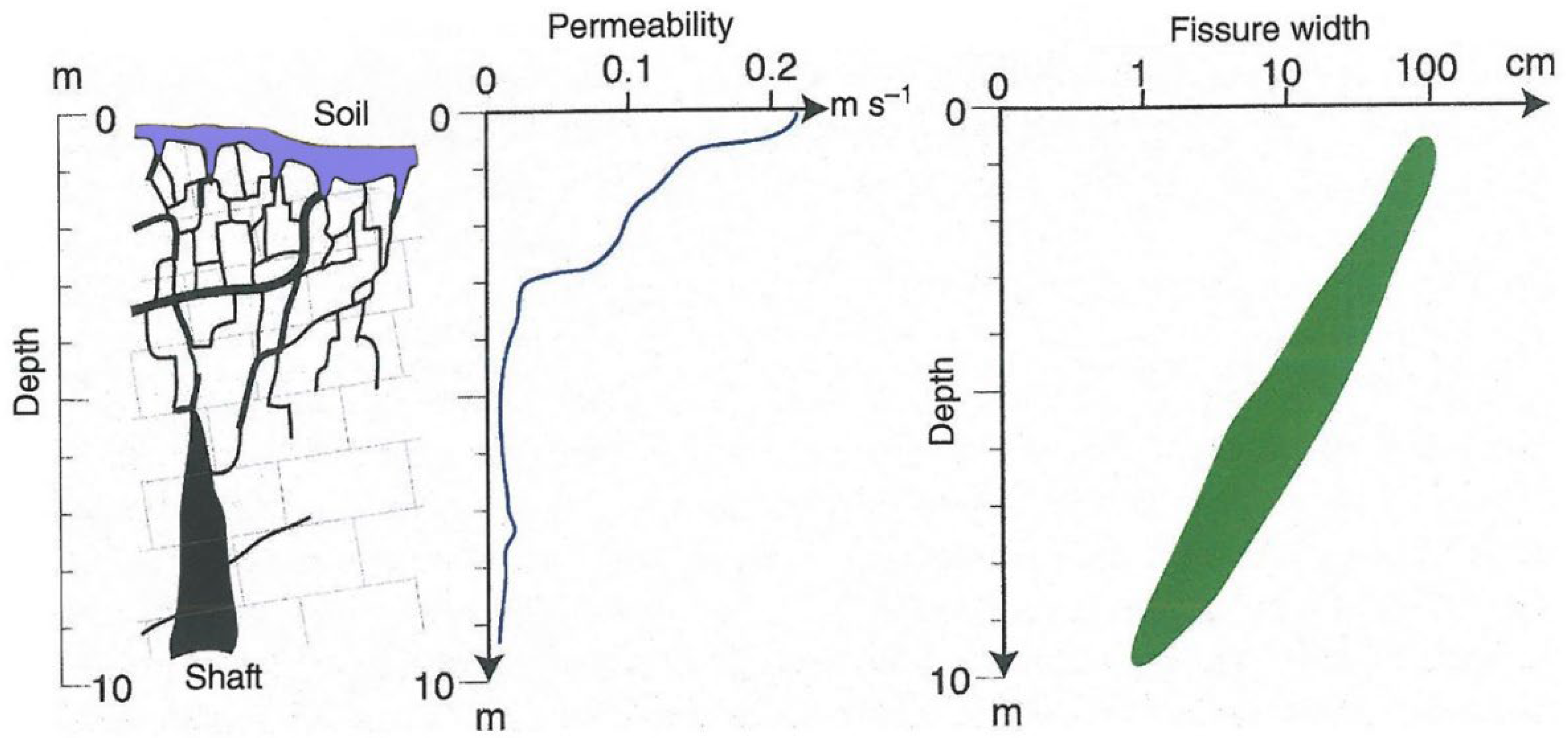
Figure 2.
Drawdown doline and epikarst development [7].
Figure 2.
Drawdown doline and epikarst development [7].

Figure 3.
sites of VES measurements (a) areas studied by mapping and by literary data (b).
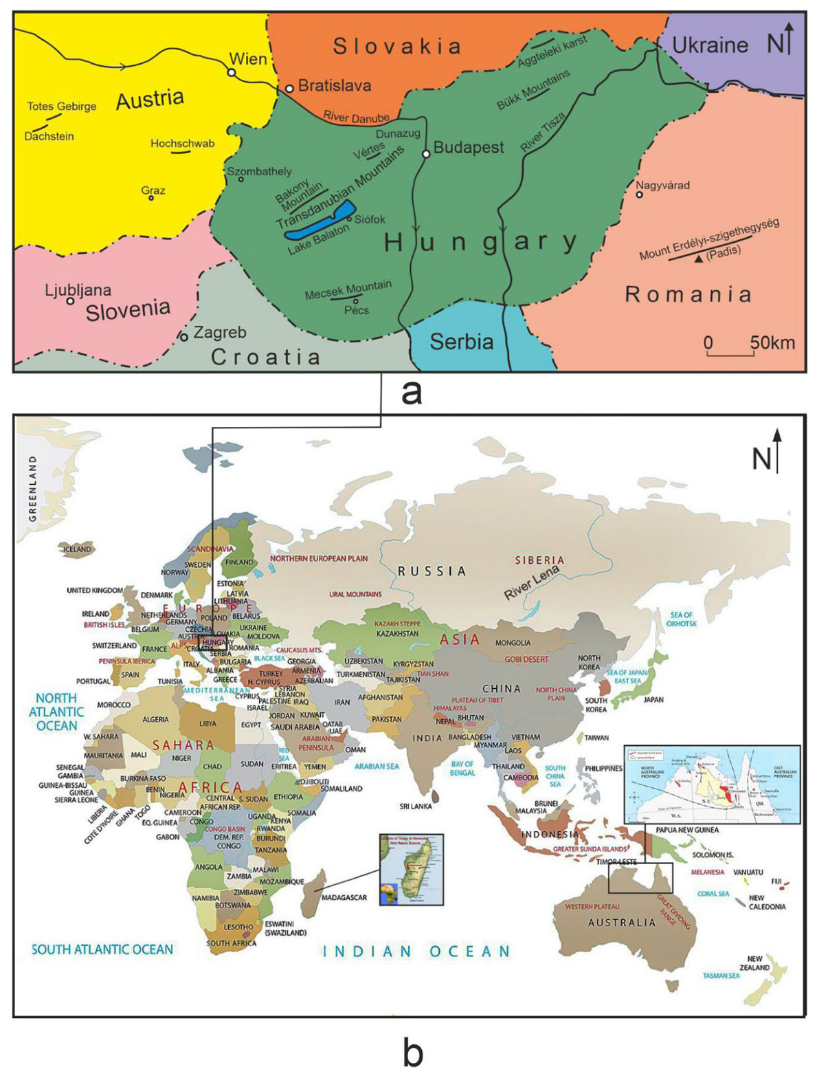
Figure 4.
Drawdown dolines of the channel of Labija Valley.

Figure 5.
Resistivity values along a profile with a drawdown doline from the Western Mecsek Karst area. Legend: 1. boundary of the mountains, 2. contour line, 3. outcrop, 4. trace of profile location, 5. limestone, 6. limestone debris (sandy?), 7. sand, sandy silt, 8. clay (with limestone debris, clayey), 9. sand-loess (with limestone debris), 10. site and number of VES measurement, 11. geoelectric resistivity of beds (Ohmm), 12. base depth of geoelectric series, 13. geoelectric resistivity of bedrock (Ohmm), 14. approximate penetration of VES measurement, 15. geoelectric series boundary, 16. road, 17. subsidence doline, 18. drawdown doline, 19. resistivity decreases.

Figure 6.
Drawdown dolines on the bedrock of Răchite (Padis [12]). Legend: 1, limestone, 2, clayey silt, 3, mixed rock debris (sand, sandstone and limestone debris), 4. VES measurement site, 5, geoelectric resistivity of the series (Ohmm), 6, basal depth of geoelectric series (m), 7, geoelectric resistivity of the bedrock (Ohmm), 8, approximate penetration of the VES measurement, 9. boundary of geoelectric series, 10, subsidence doline, 11. drawdown doline, 12. resistivity decreases, 13. plain bedrock.
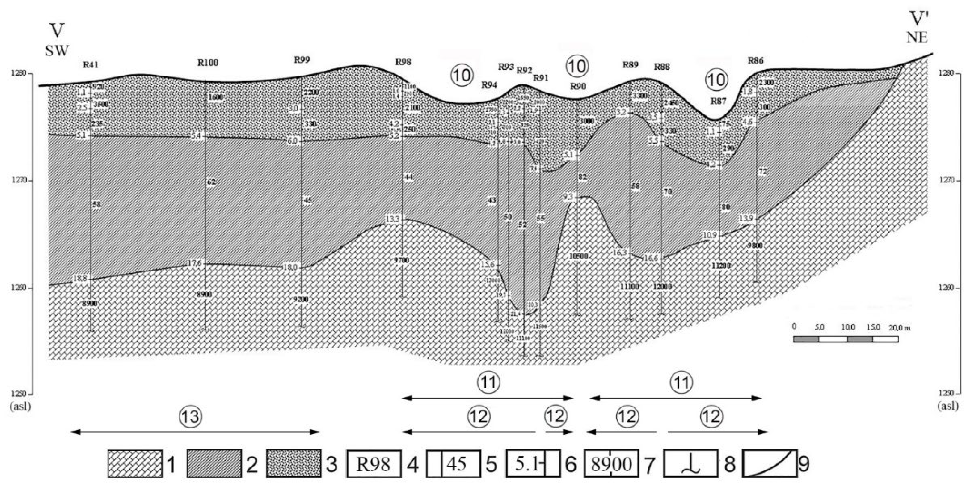
Figure 7.
Section of the geoelectric-geological profile marked A-A’ from the area of a paleodoline [12]) Legend: 1. limestone, 2. limestone debris, 3. clay with limestone debris, 4. identification code of VES measurement, 5. geoelectric resistivity of series (Ohmm), 6. base depth of geoelectric series (m), 7. geoelectric resistivity of the bedrock (Ohmm), 8. approximate penetration depth of VES measurement, 9. boundary of geoelectric series, 10. series of higher resistivity relative to its environment, 11. subsidence doline.

Figure 8.
Geological profiles of a paleodoline (Totes Gebirge, Tauplitz alm [12]). Legend: 1. limestone, 2. limestone debris (fragmented limestone), 3. limestone debris (clayey), 4. clay with limestone debris, 5. clay, 6. identification code of VES measurement, 7. geoelectric resistivity of the series (Ohmm), 8. base depth of geoelectric series (m), 9. geoelectric resistivity of bedrock (Ohmm), 10. approximate penetration of measurement, 11. geoelectric series boundary, 12. subsidence doline.
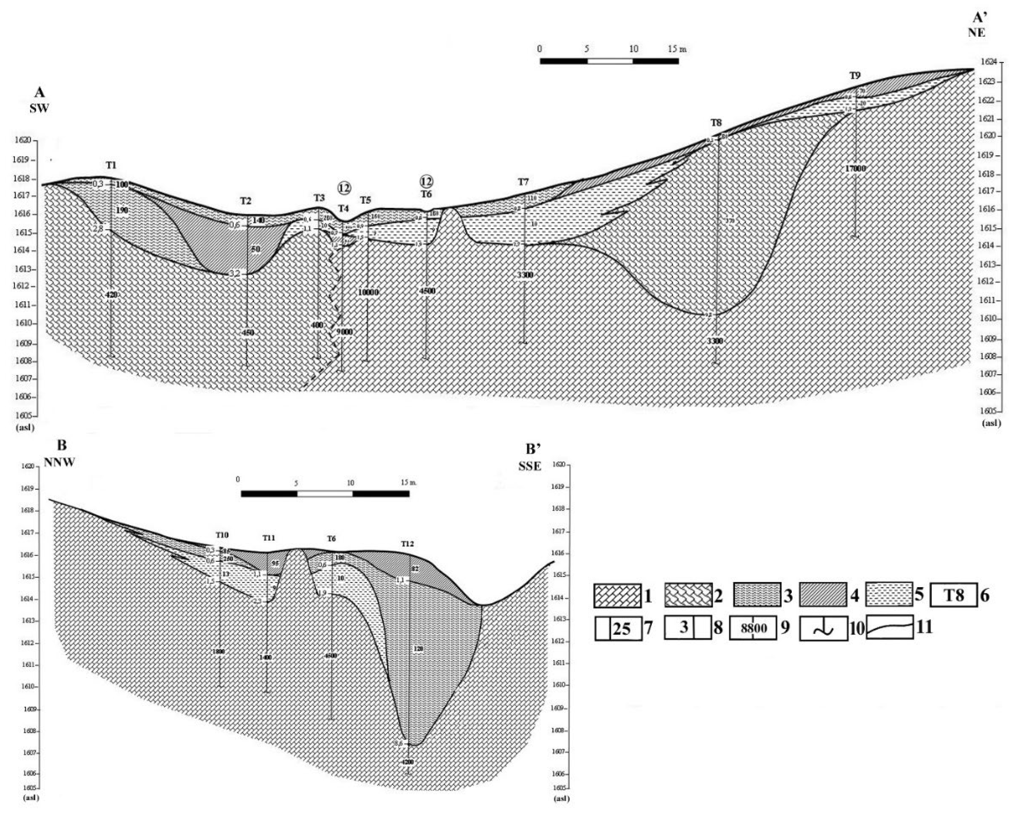
Figure 9.
The VES profile going through the Eleven-Förtés doline group. Legend: 1. contour line, 2. profile, 3. wet area, 4. site of VES measurement, 5. rock outcrop and its mark, 6. shaft, 7. excavated shaft, 8. direction of water flow.
Figure 9.
The VES profile going through the Eleven-Förtés doline group. Legend: 1. contour line, 2. profile, 3. wet area, 4. site of VES measurement, 5. rock outcrop and its mark, 6. shaft, 7. excavated shaft, 8. direction of water flow.

Figure 10.
A-A’ profile of Eleven-Förtés doline group. Legend: 1. limestone, 2. clay (with loess and with limestone detritus), 3. loess (with sand or with limestone detritus), 4. limestone detritus (with clay), 5. loess (with clay and mud) or clay with limestone detritus, 6. clay, 7. number and place of the VES measurement, 8. geoelectric resistivity of beds (Ohmm), 9. depth of bottom of geoelectric beds (m), 10. geoelectric resistivity of bedrock (Ohmm), 11. approximate penetration of VES measurement, 12.boundary of the geoelectric beds.
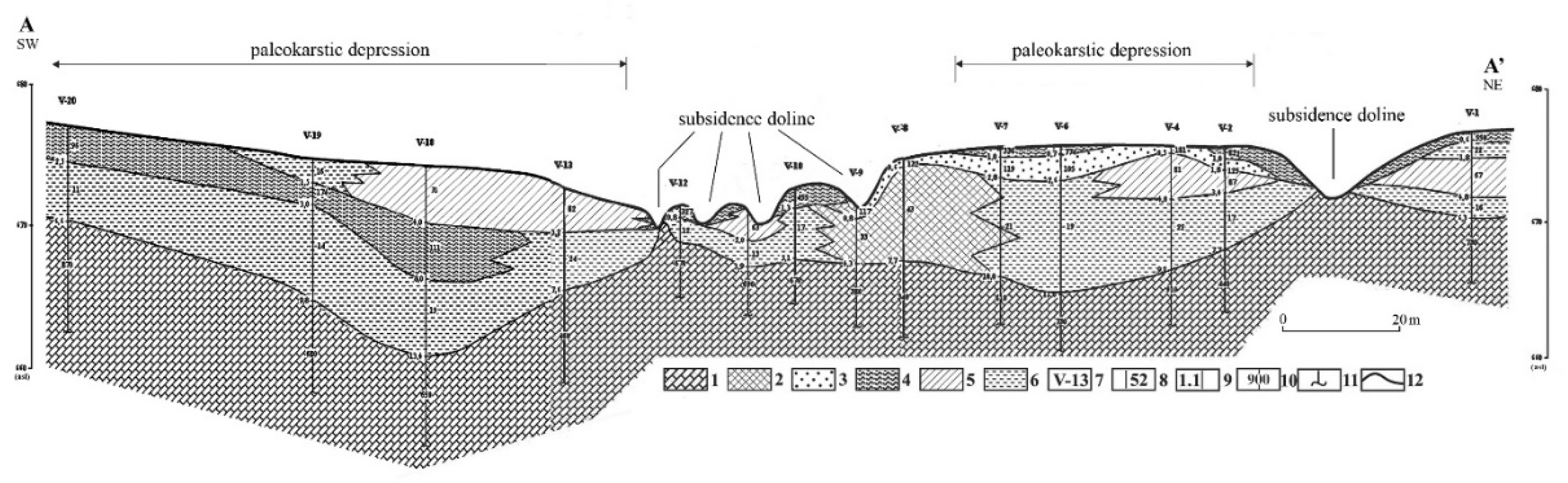
Figure 11.
Geoelectric–geological profiles marked a. A–A’ and b. B–B’ of the plate-shaped doline marked Fs1 (Zsidó-rét, Bükk Mountains) [51]. Legend: 1. limestone, 2. loess (clayey-muddy) or clay with limestone debris, 3. clay, 4. site and identification code of the VES measurement, 5. geoelectric resistivity of the series (Ohmm), 6. base depth of the geoelectric series (m), 7. geoelectric resistivity of the bedrock (Ohmm), 8. approximate penetration of the VES measurement, 9. geoelectric series boundary, 10. identification code of the rock outcrop, 11. bedrock depression, 12. partial doline 13. dividing wall between partial depressions.
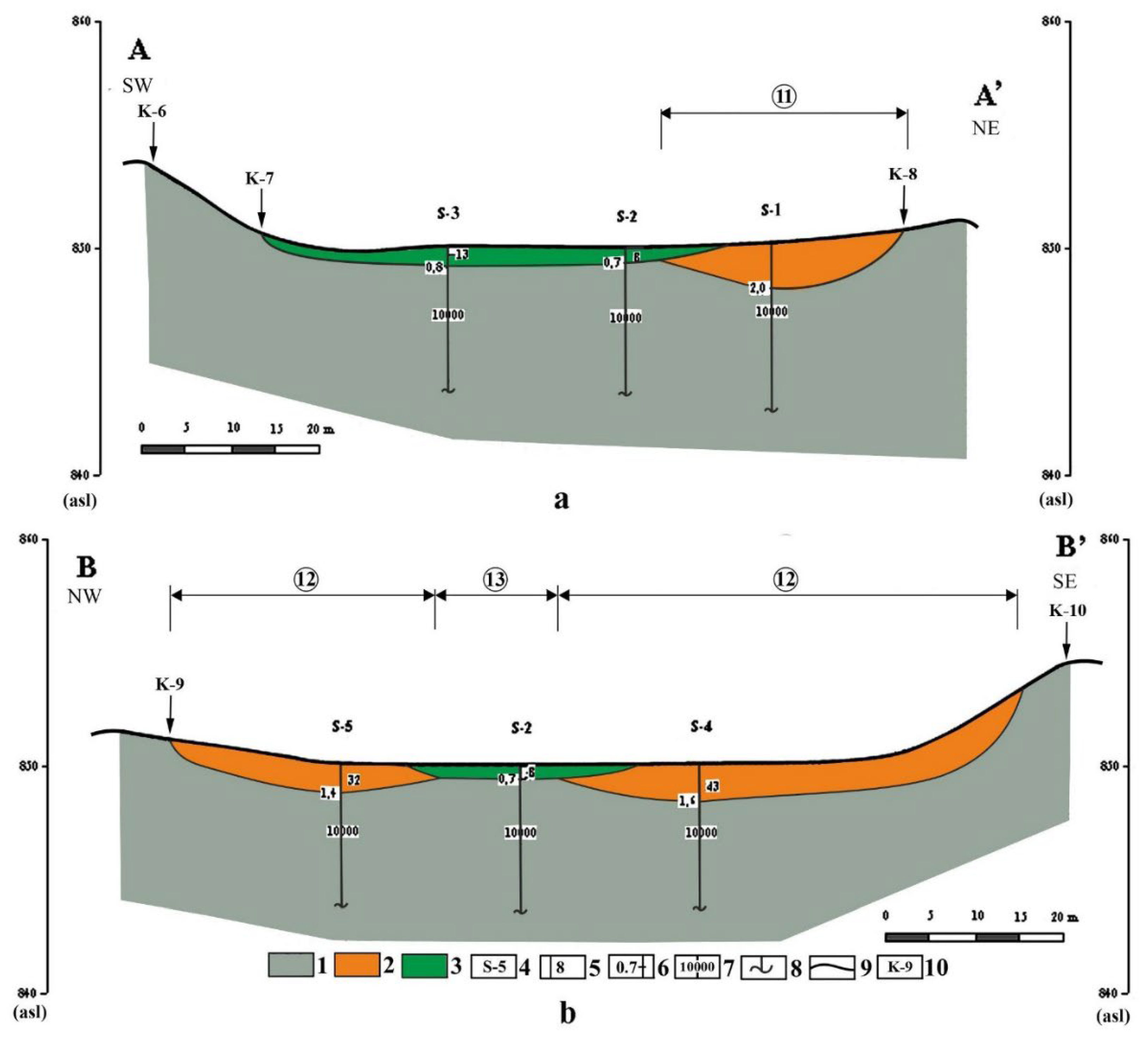
Figure 12.
Drawdown dolines of valley floor position (uvala, Aggtelek Karst). Legend: 1. limestone, 2. limestone debris (clayey), 3. clay, 4. clay (with limestone debris, sandy), 5. site and code of VES measurement, 6. geolecetric resistivity of series (Ohmm), 7. base depth of geoelectric series, 8. geoelectric resistivity of bedrock, 9. approximate penetration of VES measurement, 10. geoelectric series boundary, 11. mark of karstic depression, 12. bedrock outcrop with identification code.
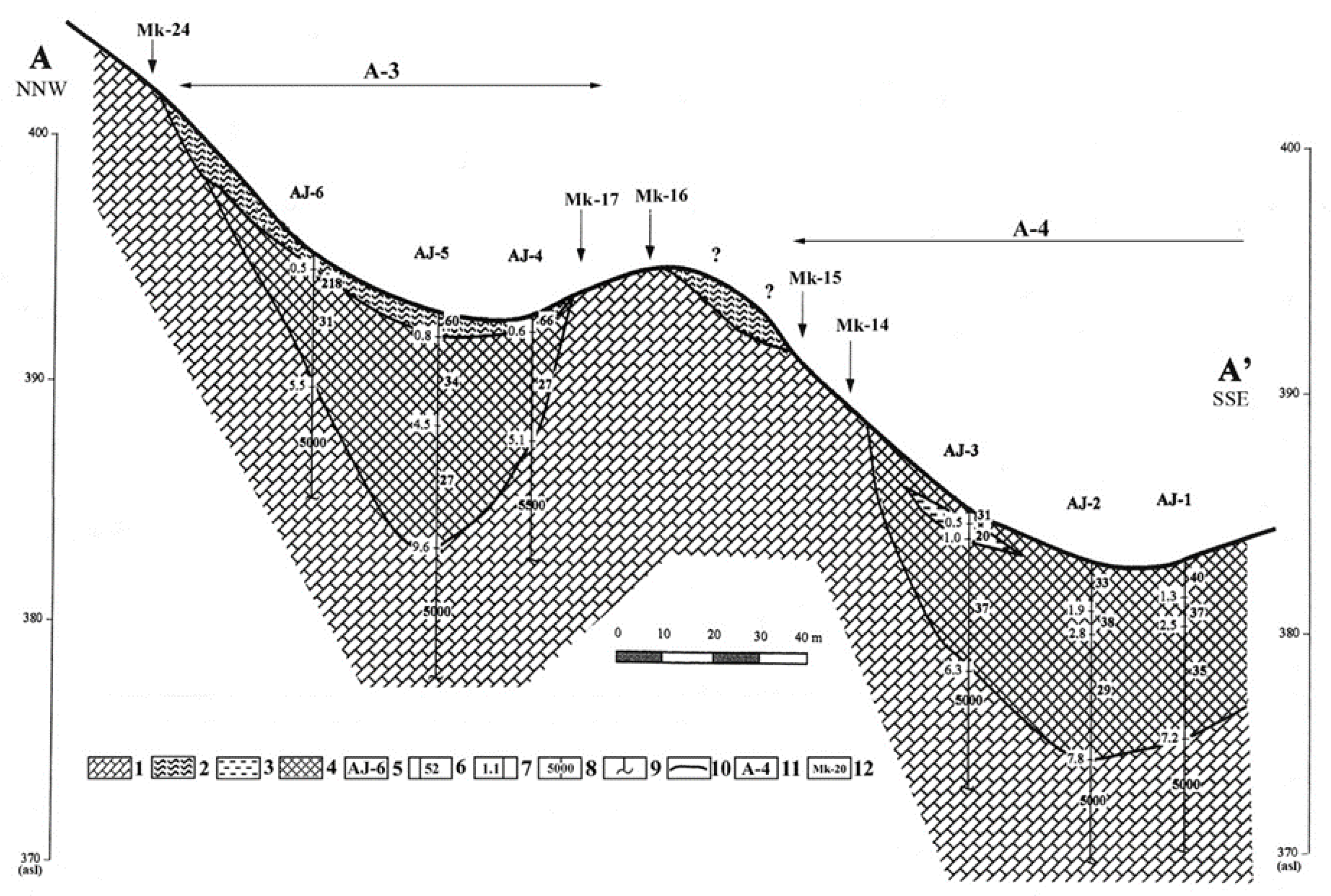
Figure 13.
Katavotra of Cirknitz polje (Slovenia).

Figure 14.
Drawdown dolines in areal development from the Bravsko-polje (Bosnia-Hercegovina) [51].
Figure 14.
Drawdown dolines in areal development from the Bravsko-polje (Bosnia-Hercegovina) [51].
Figure 15.
The position of the piezometric level and the saturation level relative to each other Legend: 1. piezometric level, 2. saturation level, a. the two surfaces are parallel with each other, b. the distance between the two surfaces increases towards the centre of the doline because the saturation level subsides faster since a larger quantity of water with better dissolution capacity arrives at the epikarst, c. the distance between the two surfaces decreases towards the centre of the doline because the piezometric surface subsides faster than the saturation level since water with better dissolution capacity but in less quantity arrives at the epikarst.
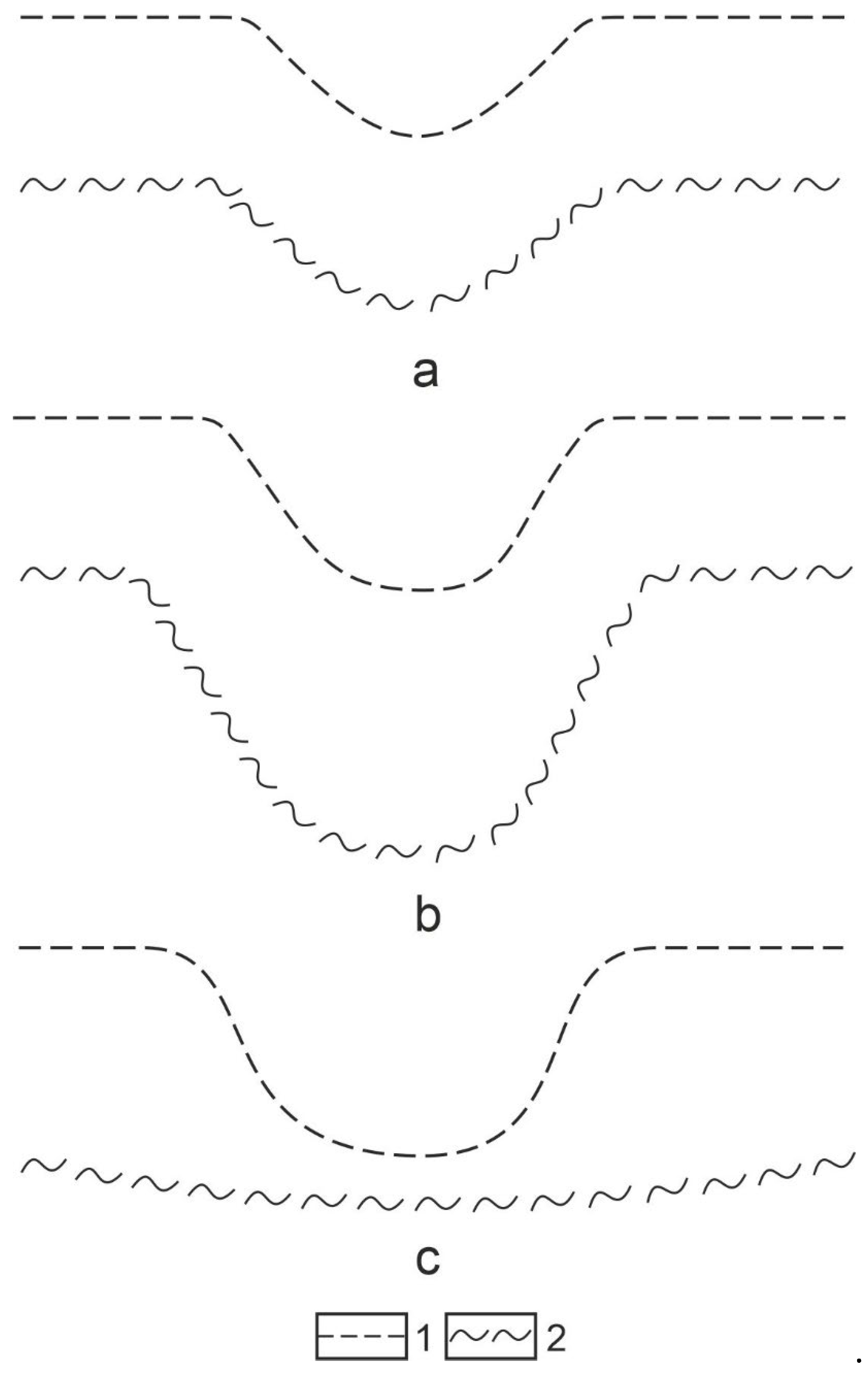
Figure 16.
The relationship among dissolution intensity, the shape, and size of drawdown doline and the piezometric level. Legend: a. the saturation level subsides faster than the piezometric level, the subsidence of the latter enables the significant subsidence of the piezometric level later therefore, the doline deepens, b. the saturation level subsides more slowly, the wet part of the epikarst is thinning, the doline is deepening to a lesser degree, if it is widening, 1. piezometric level, 2. transportation of dissolved material and the denudation of doline floor, 3. saturation level, I. initial state, II. mature state.
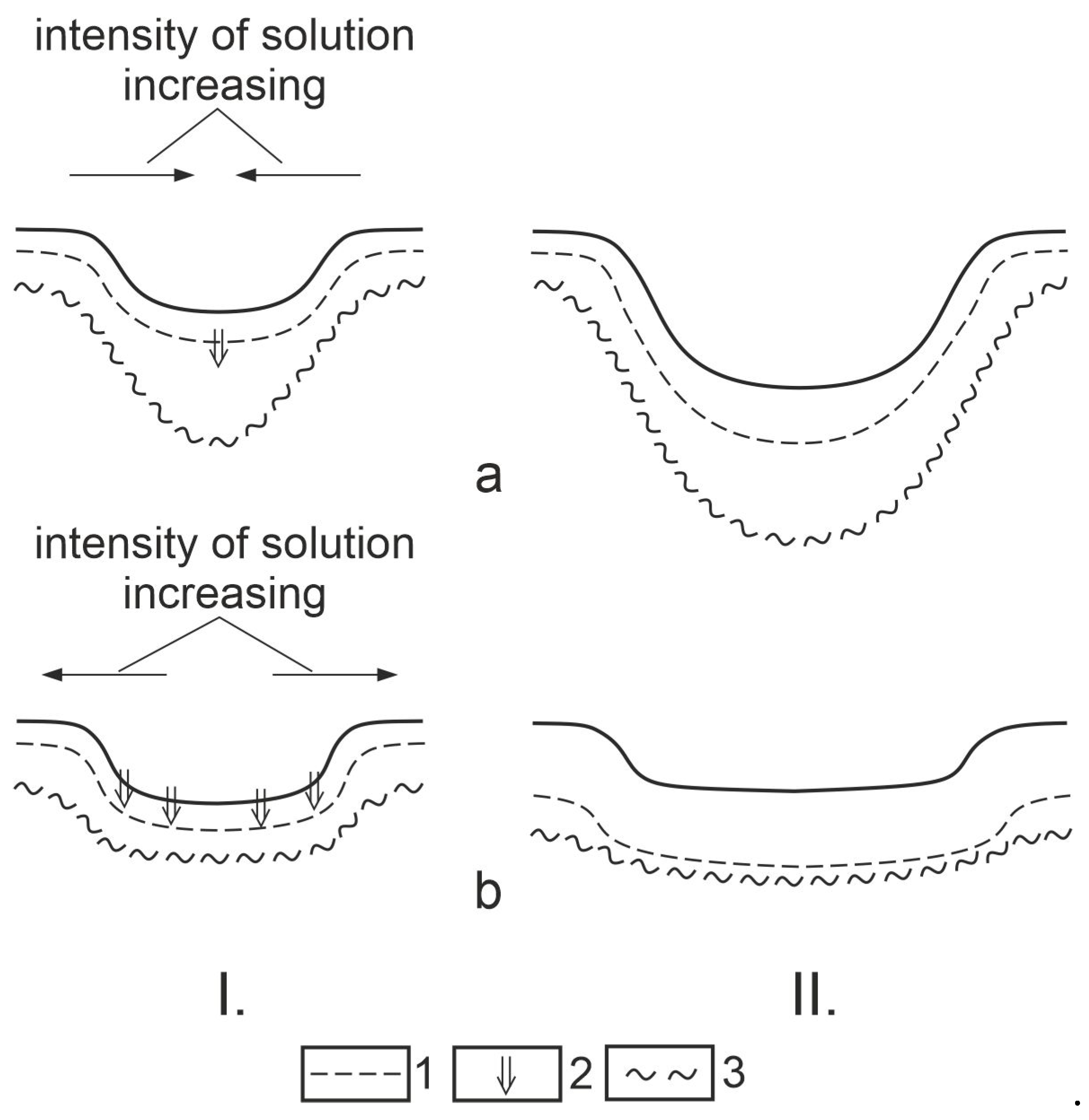
Figure 17.
The presumed position of the karstwater and the piezometric level relative to each other in a polje and its effect on the distribution of surface features. Legend: 1. karstic rock, 2. cover, 3. high karstwater table, 4. low karstwater table, 5. piezometric level, 6a. drawdown doline development with higher intensity, 6b. drawdown doline development with less intensity, 6c. plateau drawdown dolines, 7. subsidence dolines, 8. subsidence dolines with katavotra, 9. polje part permanently filled with water.
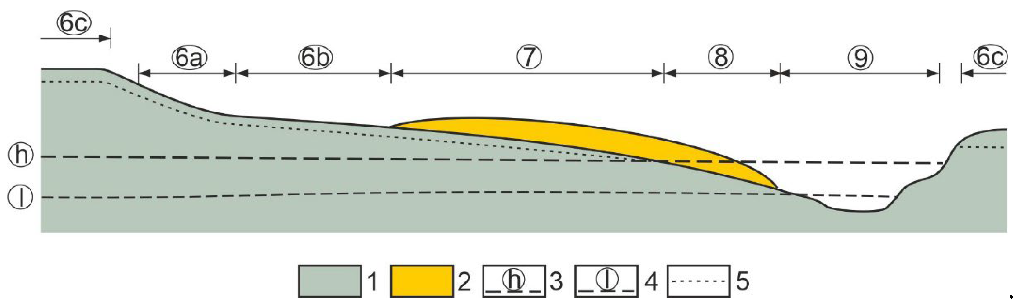
Figure 18.
The presumed position of the karstwater table and the piezometric level relative to each other at the drawdown dolines of fengcong karst, and its effect on the doline hydrology. Legend: 1. limestone, 2. caprock, 3. high karstwater level, 4. low karstwater level, 5. piezometric level, 6. karst mountain, 7. drawdown doline, 8. drawdown doline with subsidence dolines on its floor, 9. large drawdown doline 10. smaller drawdown dolines on the floor of the large drawdown doline, 11. subsidence dolines with katavotra on the floor of the large drawdown doline.
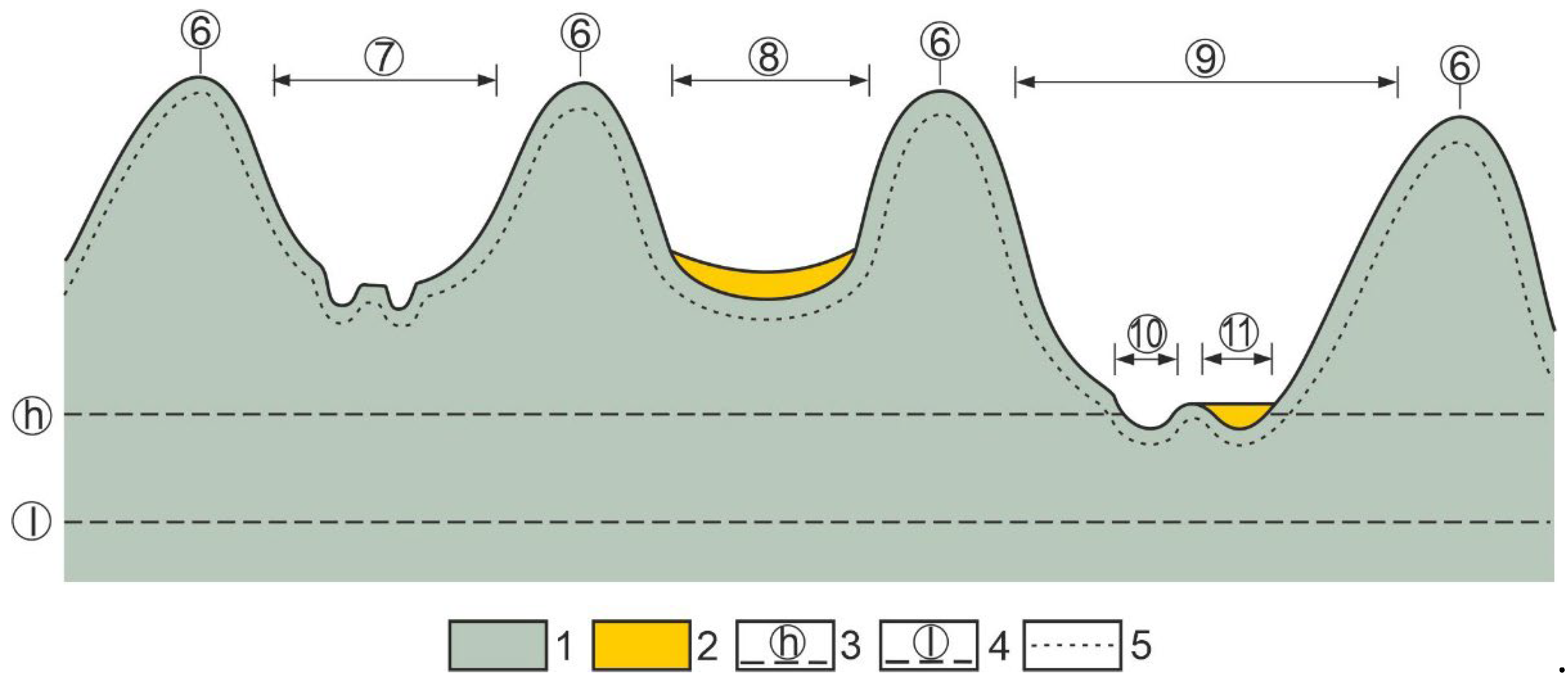
Figure 19.
Different phases of the coalescence of grikes and the Bullita cave in Judbarra Karst [66].
Figure 19.
Different phases of the coalescence of grikes and the Bullita cave in Judbarra Karst [66].
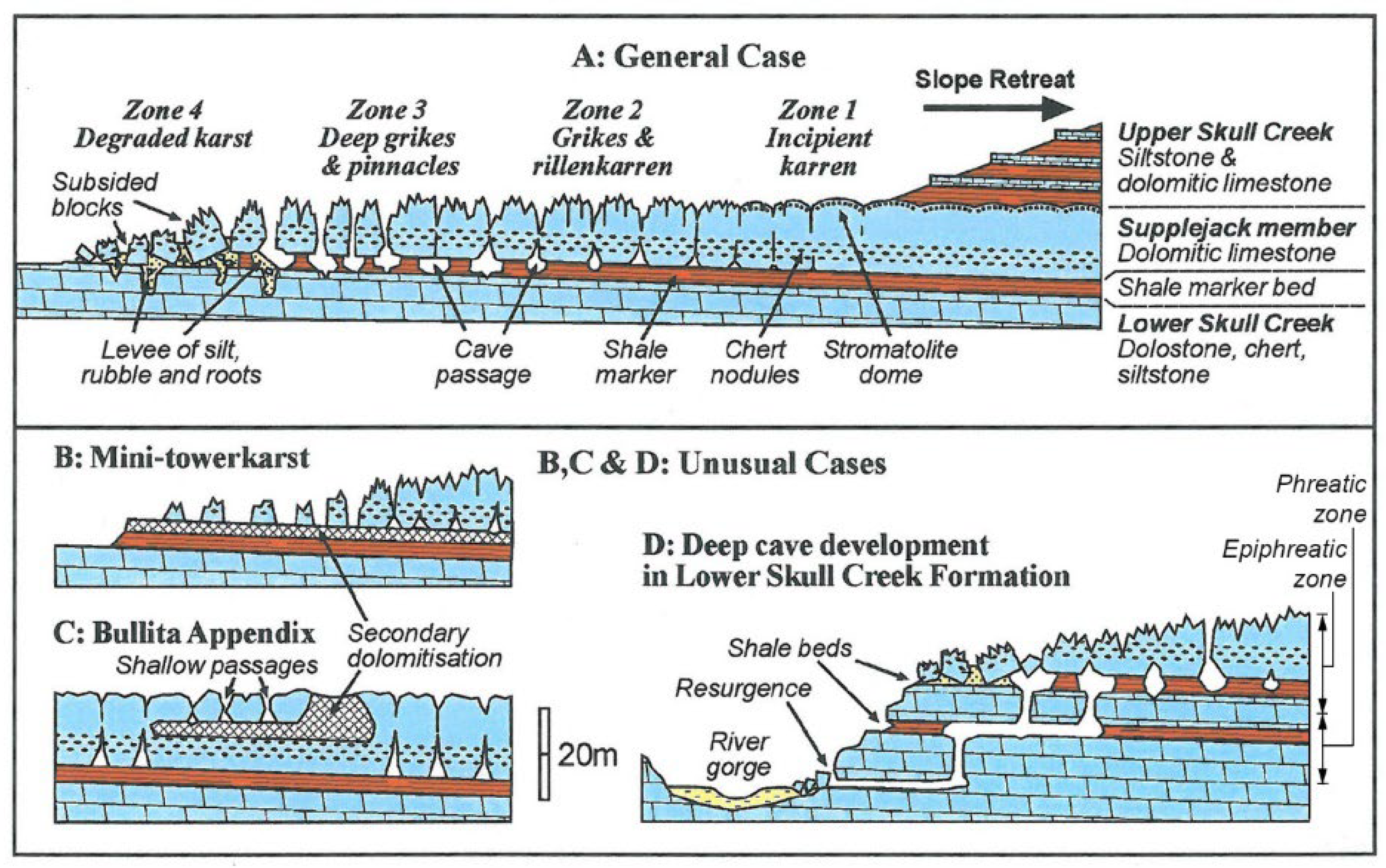

Table 1.
Resistivity values in the bedrock below drawdown dolines.
| area | number of profiles taken into consideration (profile) |
number of VES measurements (measurement) |
average penetration of measurement into the bedrock relative to the bedrock surface (m) | average resistivity1 (Ohmm) | site of profile |
|---|---|---|---|---|---|
| Apuseni Mountains, Padis Răchite (Romania) | 3 | 46 | 4.55-8.58 | 11385.44 | closed area enclosed by mounds with buried recent depressions on the bedrock, with subsidence dolines at its surface |
| Apuseni Mountains, Padis Răchite (Romania) | 5 | 34 | 4.76-6.96 | 10335.83 | closed area enclosed by mounds, plain bedrock with subsidence dolines at its surface |
| sum and average at Răchite | 8 | 80 | - | 10860.63 | |
| Hideg Valley Aggtelek Karst, | 1 | 6 | 4.4-5.4 | 5220 | solution dolines (soil-covered karst), recent |
| Czigány-földek, Mecsek Karst inner part of drawdown dolines | 4 | 25 | 5.16-6.56 | 4730.78 | in drawdown doline subsidence dolines |
| Czigány-földek Mecsek Karst margin of drawdown dolines | 4 | 19 | 5.61-7.12 | 3818.45 | in drawdown doline subsidence dolines |
| Czigány-földek sum and average | 4 | 44 | - | 4274.61 | |
| Hochschwab | 3 | 19 | 5.39-11.54 | 5258.98 | large paleodepression, with covered karst, subsidence dolines |
| Totes Gebirge | 2 | 13 | 0.5-5 | 4176.4 | paleodoline, with covered karst, subsidence dolines |
| Zsidó-Rét, Bükk Mountains | 2 | 6 | 4.65-5.81 | 10000 | floor of plate-shaped doline |
| sum and average | 20 | 168 | - | 6274.43 | drawdown dolines (recent and paleokarstic) |
1 from the average of profiles.
Table 2.
Resistivity values in the bedrock when there are only subsidence dolines.
| area | number of profiles taken into consideration (profile) |
number of VES measurements (measurement) |
average penetration of measurement into the bedrock relative to the bedrock surface (m) | average resistivity1 (Ohmm) | site of profile |
|---|---|---|---|---|---|
| Bakony Mountains, eastern part of Tés Plateau | 14 | 104 | 3-10 | 315 | mostly on valley floor |
| Bakony Mountains, Eleven-Förtés | 10 | 68 | 5-7 | 611 | inactive depression, with subsidence dolines in its area |
| Bakony Mountains, northern part of Mester-Hajag | 18 | 137 | 3-8 | 1273 | area enclosed by mounds with subsidence dolines |
| sum and average | 42 | 309 | - | 733 | |
| Cigány-földek Mecsek karst outside solution dolines | 2 | 11 | 4.7-6.2 | 3785.50 | subsidence dolines |
| area next to Răchite | 2 | 8 | 2.49-6.37 | 8443.33 | valley-floor covered karst with subsidence dolines |
| Dachstein2 | 1 | 7 | 10-15 | 868.56 (453.86) | paleodoline |
| sum and average | 47 | 328 | - | 2885.57 | - |
1from the average of profiles. 2the data were left out of the average calculation since the measurement was made in a drawdown doline, the value in the brackets was calculated without higher and deeper resistivity values.
Table 3.
Bedrock resistivity data at bearing profiles at the subsidence dolines of the Bakony Region.
Table 3.
Bedrock resistivity data at bearing profiles at the subsidence dolines of the Bakony Region.
| mark of doline | area | resistivity [Ohmm] | profile length (m) | measurement number | ||
|---|---|---|---|---|---|---|
| below the doline | average along profile | largest difference | ||||
| I-16 | Tés 3 | - | 346.4 | 92.00 | 100 | 5 |
| I-23 | Tés 2 | - | 350.00 | 0.00 | 30 | 2 |
| I-24 | Tés 2 | - | 275.00 | 120.00 | 200 | 4 |
| I-32 | Tés 1 | - | 252.62 | 170.00 | 200 | 8 |
| I-33 | Tés 1 | - | 301.28 | 186.00 | 260 | 7 |
| H-1 | Homód Valley | - | 307.00 | 390.00 | 144 | 8 |
| E-6 | Eleven-Förtés | - | 758.57 | 660 | 105 | 7 |
| I-25 | Tés 2 | 230 | 306.67 | 90.00 | 10.8 | 5 |
| I-27 | Tés 2 | 360 | 400.67 | 178.00 | 60 | 3 |
| H-2 | Homód Valley | 200 | 252.5 | 140 | 126 | 5 |
| H-6 | Homód Valley | 170 | 278.75 | 180 | 300 | 8 |
| E-1 | Eleven-Förtés | 360 | 688 | 650 | 180 | 10 |
| E-2 | Eleven-Förtés | 650 | 840 | 690 | 87 | 6 |
| E-5 | Eleven-Förtés | 560 | 645 | 10 | 26 | 2 |
| I-17 | Tés 2 | 310 | 251.63 | 80 | 75 | 8 |
| I-18 | Tés 3 | 370 | 248.2 | 83 | 60 | 5 |
| I-26 | Tés 2 | 340 | 275.00 | 200 | 12 | 7 |
| I-311 | Tés 1 | 430 | 272.28 | 125 | 213.33 | 7 |
| H-8 | Homód Valley | 390 | 303.33 | 220 | 300 | 9 |
| E-3 | Eleven-Förtés | 670 | 550 | 780 | 118.33 | 5 |
| MH18 | Mester-Hajag | 1500 | 1700 | 1000 | 67.5 | 5 |
| MH22 | Mester-Hajag | 1600 | 1660 | 900 | 52.5 | 5 |
| MB-50 | Mester-Hajag | 335,0 | 493,89 | 160 | 100.67 | 9 |
| F-21 | Fehérkő Valley | 1390 | 1420 | 1330 | 118.00 | 7 |
| MH10 | Mester-Hajag | 1800 | 1271.67 | 1000 | 80.00 | 6 |
| MH411 | Mester-Hajag | 2000 | 1862.5 | 1000 | 92.5 | 8 |
| MH52 | Mester-Hajag | 1400 | 1262.5 | 900 | 80.00 | 8 |
| MB411 | Mester-Hajag | 510 | 505.6 | 156 | 196.67 | 10 |
| F1 | Fehérkő Valley | 2500 | 1987.14 | 2720 | 65.78 | 7 |
| E-82 | Eleven-Förtés | 1100 | 646 | 740 | 72.5 | 5 |
++ excavated by wrecking. 1doline with bedrock depression, the other dolines are above bedrock mound.
Table 4.
Average resistivity values of the profiles bearing the dolines by doline groups.
| mark of doline mark of group |
area | resistivity [Ohmm] | shaft (total) [shaft] |
doline case number [doline] |
potential water supply into the karst | ||
|---|---|---|---|---|---|---|---|
| average resistivity of the bedrock at the dolines of the doline group | average resistivity of profile sections that bear the dolines of doline groups | largest resistivity difference of doline groups | |||||
| E | Tés, Homód Valley, Eleven-Förtés | - | 370.13 | 229.71 | 7 | n=7 | a lot of |
| B | Tés, Homód Valley, Eleven-Förtés | 367.14 | 487.37 | 276.86 | 1 | n=7 | a lot of |
| A | Tés, Homód Valley, Eleven-Förtés | 418.33 | 323.41 | 248.0 | 1++ | n=6 | little |
| D | Mester-Hajag, Fehérkő valley | 1206.25 | 1318.47 | 847.5 | 0 | n=4 | little |
| C | Mester-Hajag, Fehérkő Valley | 1551.67 | 1255.90 | 1086.2 | 0 | n=6 | little |
Notice: ++ excavated by wrecking.
Table 5.
The position of karstwater table relative to the surface in some tropical karren of Bemaraha type.
Table 5.
The position of karstwater table relative to the surface in some tropical karren of Bemaraha type.
| Karst area | place | elevation difference between karst surface and karstwater table | source | relative to | features proving coalescence by dissolution | source | distance from sea (km) |
|---|---|---|---|---|---|---|---|
| Bemaraha Great Tsingy | Madagascar | 50-90 | [25] | sea level | interrupted by a cave going through a grike | [25] | 30 |
| Bemaraha Little Tsingy | Madagascar | 0-25 | [25] | River Manambolo | notch, arch | [25] | MR |
| Broken River | Australia | 38-43 | [57] | base level of erosion | A | [20] | 180 |
| Chillagoe | Australia | 90-14 | [57] | spring cave | A, B | [20] | 100 |
| near Coles Creek (Barkly Karst) | Australia | 16-22 | [57] | spring cave | A, B | [20] | 180 |
| Fanning River | Australia | 75-79 | [57] | spring cave | A | [20] | 80 |
| Judbarra Karst | Australia | 40-60 | [21] | East Baines River | A, B | [20,21] | EBR |
| Mount Etna | Australia | 15-23 | [57] | spring cave | A | [20] | 37 |
| West Kimberly region | Australia | 78-65 | [57] | spring cave | B (?) | [20] | 260 |
| Tanga Karst | Tanzania | 32-41 | [47] | se level | A, B | [47] | 0 |
| west from Coles Creek | Australia | 16-22 | [56] | to spring cave | A, B | [20] | 320 |
| Bau Region | Borneo (Sarawak) | 23-35 | [56] | spring cave | A | [57] | JR |
1a the two data of elevation differences are the average of the altitude of the spring cave with the lowest and the most elevated position. A: connected to fissure cave. B: coalesced grike and cave. MR: Manambolo River. EBR: East Baine River. JR: Jahara River.
Table 6.
Distribution of precipitation data on the studied tropical karren.
| karst area | site of precipitation data | annual precipitation (mm) | the wettest month | percentage (%) of the wettest month relative to the annual | source |
|---|---|---|---|---|---|
| Judbarra Karst | Timber Creek | 926 | 207 (January) | 22.3 | [21] |
| Bemaraha Tsingy (Great Tsingy, Little Tsingy) | Morondava | 780 | 257.16 (January) | 32.96 | [59] |
| Kimberley Karst | Fitzroy Crossing | 541 | 150 (January) | 27.73 | [21] |
| Barkly Karst | Cam Do Weal | 387 | 90 (January) | 23.25 | [21] |
| Chillagoe | Chillagoe | 856 | 220 (February) | 25.73 | [21] |
| Barkly Karst | Boulia | 242 | 50 (February) | 20.66 | [21] |
| Mount Etna | Rockhampton | 943 | 2190 (February) | 20.02 | [21] |
| Tanga Karst | Tanzania | 2874 | 418 monthly (December, January, February) | 15.24 | [58] |
| Broken River | Townsville | 1096 | 338 (February) | 30.83 | [58] |
| Fanning River | Townsville | 1096 | 338 (February) | 30.83 | [58] |
Disclaimer/Publisher’s Note: The statements, opinions and data contained in all publications are solely those of the individual author(s) and contributor(s) and not of MDPI and/or the editor(s). MDPI and/or the editor(s) disclaim responsibility for any injury to people or property resulting from any ideas, methods, instructions or products referred to in the content. |
© 2024 by the authors. Licensee MDPI, Basel, Switzerland. This article is an open access article distributed under the terms and conditions of the Creative Commons Attribution (CC BY) license (http://creativecommons.org/licenses/by/4.0/).
Copyright: This open access article is published under a Creative Commons CC BY 4.0 license, which permit the free download, distribution, and reuse, provided that the author and preprint are cited in any reuse.


