Submitted:
26 June 2024
Posted:
29 June 2024
Read the latest preprint version here
Abstract
Human-elephant conflict poses serious conservation challenge in Asia and Africa. We deployed an AI-based camera-alert system in a conflict hotspot in West Bengal, India that accurately detected elephants near villages (266 events) and transmitted real-time alerts ( = 42 seconds). Among detections of separate age and sex classes, lone adult bulls were the most prone to conflict. Real-time alerts permitted rapid response by field personnel to prevent conflict at the site ( = 18.2, SD = 12.4 min to arrival). Frequent detections of humans (33,217 events) on elephant trails highlighted the value of real-time alerts. Four human fatalities and five serious injuries occurred in the study area over a two-year period prior, but none during the study (2023-2024) after deploying the AI-alerting system. Loss of lives and livelihoods underscore the urgency of applying this approach to other elephant ranges and adapting AI models to other conflict-pronespecies to promote coexistence.
Keywords:
Human-Elephant Conflict
; Coexistence
; TrailGuard AI
; Real-time Alert
; Rapid Response
Introduction
Minimizing human-wildlife conflict (HWC) requires a shift in local attitudes through effective incentive programs, mitigation measures, and prevention; these components become the stepping stones to increased tolerance and coexistence (Blackwell et al. 2016; Banerjee & Aiyadurai, 2022; Gross et al. 2022). A case in point is the persistence of wild elephant populations occurring in multi-use landscapes of Asia and Africa where levels of human-elephant conflict levels have escalated considerably and, in some regions, reached a crisis stage (Sampson et al. 2018; Schaffer et al. 2019; Gross et al. 2021; Matsuura et al., 2024). Even in parts of the range currently unaffected, the increasing interface between natural habitats and human settlements suggest that future conflict appears likely (Guarnieri et al. 2024). In both Asia and Africa, elephants are responsible for far more human deaths and injuries than any other mammal species, leading to public antagonism towards their conservation (Wakoli & Sitati, 2012; Goswami et al. 2014; Williams et al. 2020). Along with crop loss, the other forms of economic costs associated with negative human-elephant interactions are also escalating (Jadhav & Barua, 2012; Mayberry et al. 2017; Terada et al. 2021). In many Asian countries, adequate compensation is often considerably delayed, inadequate, or unavailable (DeMotts & Hoons, 2012; Gubbi, 2012; Chen et al. 2016; Guru & Das, 2021). Much of the conflict can be attributed to humans occupying former elephant habitat (Denninger-Snyder et al. 2019; Schaffer et al. 2019; Anoop et al. 2023; Singh et al. 2023). Even in conservation areas that are extensively fenced and insular, human-elephant coexistence—defined as a dynamic, but sustainable state in which elephants (and other wildlife) co-adapt to living in shared landscapes (Mekonen, 2020)—is the practical long-term conservation strategy. This preferred outcome applies to densely populated countries like India, which harbors over 60% of the extant populations of Asian wild elephants (Pandey et al. 2024).
India has an estimated population size of 30,000 wild individuals (Pandey et al. 2024; Williams et al. 2020). Elephants are distributed among 24 states, but the southern region harbors the largest population, followed by the northeast region, northwest and the east-central region, respectively (Figure 1; Project Elephant, 2017). India experiences a relatively high rate of human fatalities caused by elephants (Natarajan et al. 2023; Singh et al. 2023; Pandey et al. 2024), recording 1,579 human deaths since 2019. During the same period, 490 elephant deaths due to unnatural causes were reported (Choubey, 2023). These statistics on human fatalities and injuries highlight the potential risks to both humans and elephants in the interface areas with long-term negative feedback for elephant conservation. Thus, mitigating HEC remains a priority for the government, often working in collaboration with local and global civil society organizations that offer technical expertise (Nayak & Swain, 2022; Pandey et al. 2024). In the interface zones, measures to minimize HEC have included: excavation of trenches at village-forest boundaries; manual tracking with trained trackers; use of manually or automatically triggered sound mechanisms (e.g., sirens, loud noises, and firecrackers); erection of fences (solar, bee hives, and spiny plants as a bio-fence); and fire used as a scare mechanism (Fernando et al. 2008; King et al. 2017; Neupane et al. 2018; Shaffer et al. 2019). However, the intelligence and learning capabilities of elephants typically diminishes the effectiveness of such measures over time (Nelson et al. 2003; Goodyear, 2015).
Effectively minimizing HEC depends upon early awareness and appropriate timely response. In this regard, technological innovations can play an important role, especially if they can harness advances in embedded AI algorithms, communications hardware, and software. Here, we report on an innovation to detect elephant movement and promote coexistence among Asian elephants, village communities, and subsistence farmers in the state of West Bengal, India. The central feature of the innovation is an AI-embedded camera-alert system, TrailGuard AI, that detects objects of interest and transmits images in real time of humans and other key wildlife species. This technology was earlier deployed beginning in 2022 in India to detect tigers moving in close proximity to villages in Madhya Pradesh (Dertien et al. 2023). The current project is the first to employ embedded-AI to detect elephants leaving protected forests to move along roads, trails, and routes bordering human settlements (as opposed to CCTV-cameras transmitting data to a server where AI inference is performed as is now in operation in several states in India). The main objective of the technology was to send alerts in real time to local field staff to improve the response time to a conflict situation, and simultaneously mobilize rapid response teams to prevent fatalities and injuries. We present the findings of the recent deployment (still on-going through 2024) that are relevant to replication of AI-embedded camera-alert systems elsewhere in the elephant range and, using the same or similar AI models, to detect other conflict-prone species globally. To this end, we addressed the following questions:
- Can the AI system accurately detect elephants, especially at night, when animals tend to move towards villages and during the day on trails used by humans?
- Can real-time alerts of elephant activity on these paths assist local forest staff to safely track elephants?
- Can event-triggered rapid response by the field personnel contribute to reduction in loss of human life and injuries and otherwise minimizing human-elephant interactions?
- How do local stakeholders perceive the rapid-response system and does effective implementation elicit in them the willingness to coexist with elephants?
Besides these questions, we assessed comparative costs of implementing this AI-based alerting system versus two other common protocols employed to address conflict or damage caused by elephants. First, we compared the costs associated with monitoring elephants via GPS-satellite tracking collars. Second, post-conflict, we considered costs of compensation payments for losses to the victims.
Finally, we propose embedding this novel technology within other approaches in conflict hotspots that could promote coexistence with elephants, and with adaptation, extend to other species.
Method
The TrailGuard AI alert system was deployed in two phases totalling 30 units. The majority of the units were placed on trails used by elephants as confirmed in a reconnaissance phase by forest rangers and villagers in early November 2023. Monitoring began in early December 2023 and continued through April 2024 (although at the request of the WBFD, the deployment of the technology has been extended indefinitely). A more detailed description of the camera technology is presented in Dertien et al. (2023) and deployment procedures elsewhere (SM-Appendix 1).
Collaborators and Study Area
This study was conducted in a multi-use landscape in a non-Protected Area territorial forest division along the southern border of the Indian state of West Bengal between October 2023 – April 2024. This field effort was a collaboration among the West Bengal Forest Department (WBFD), the Japan International Cooperation Agency (JICA), Nightjar India (as the technical partner) and RESOLVE (as the scientific partner) to provide real-time occurrence and movement data of elephants to relevant stakeholders living along the forest-village boundaries within the Jhargram Forest Division (Figure 1 inset). West Bengal supports a relatively small population of elephants (~700 individuals). Yet, like other states of the east-central region—Chhattisgarh, Jharkhand, and Odisha—conflict has resulted in a disproportionate loss of human lives (Natarajan et al. 2023). The study area, the Jhargram Forest Division, epitomizes the problem: elephant habitat has been reduced to plantation-like forest islands, dominated by the native hardwood, sal (Shorea robusta), dispersed in a mosaic of human habitation. Jhargram district encompasses a geographical area of 3,100 km2; nearly 80% is under agriculture (~2,700 km2) and only 18% is covered by dry deciduous forests dominated by coppice crops of sal extending across 477 km2 and exotic monoculture over another 118 km2 (cumulatively 600 km2) (Mandal & Chatterjee 2021). Most of the 1.1 million people residing in Jhargram district are rural (97%) and a smaller fraction are urban dwellers (3%) (Chandramouli & General, 2011). Rural communities are composed of economically challenged scheduled castes and scheduled tribes (Santhal, Lodha, Sabar and Kheria), along with migrant populations from Odisha, Jharkhand, and Bihar (Figure 1). Most are subsistence farmers with small landholdings. Paddy (irrigated rice), lentils, mustard, maize, and vegetables are the main crops grown in the area. The dependence on forest resources includes fuelwood and the gathering of non-timber forest products such as the flowers of mahua (Madhuca latifolia), berries, and other edible species.
The “Protected Forests” category of Jhargram are divided into eight forest ranges. Sharing borders with the states of Jharkhand in the west, Odisha in the south, and the forest divisions of Kharagpur and Paschim Midnapore in the east and southeast, respectively, Jhargram links a larger elephant landscape that includes two elephant reserves (Singhbhum, in Jharkhand and Mayurjharna, in West Bengal) used by nearly 200 elephants (Singh et al. 2023). The study area is in a relatively dry region of the Chota-Nagpur plateau which experiences an annual water deficit. Yet, the presence of elephants in this larger landscape—particularly across the three districts of West Bengal—has increased eleven-fold since the 1950s (Singh et al. 2023). This population growth has increased interactions between humans and elephants across the entire Jhargram Forest division where 20-22 human deaths have been annually reported between 2021-2023.
Use of AI to Detect Elephants in Multi-Use Landscapes
Senior staff of the WBFD stated a clear guideline for AI monitoring: reduce the chances of elephants being “missed” when heading towards villages (i.e., going undetected or false negatives). Second, given the high likelihood of detections of humans along the same routes in this multi-use landscape, they required the AI monitoring to filter out human detections to avoid saturation of images that would appear as alerts in the inboxes of designated recipients. The AI models used in filtering the data in the TrailGuard AI system and the monitoring protocol was adapted to address these concerns using a two-step process. First, AI inference was performed on the images by TrailGuard’s embedded computer vision chip, where the AI algorithm can detect multiple classes including elephants and humans, which were the focus of this study, using a multi-class detector created by CVEDIA (CVEDIA.com). In the edge detector, we deliberately set the probability threshold for detecting the elephant output class to an extremely low level (0.20) to avoid false negatives (missing the detection of elephants). Second, images with positive inferences were transmitted via the cellular network to the server, where an in-house trained model performed a second inference to: 1) independently verify and classify the object; and 2) filter out any remaining false positives before transmission to designated authorities (Figure 2).
To assess the reliability and capability of the AI-based models in detecting elephant presence, we calculated precision and recall for the output class for both the edge and server-based detectors. For the edge detector, we computed these statistics by analysing captured images and the respective inference results stored on the SD cards in each of the TrailGuard units deployed in the field (SM-Appendix 2).
Elephant detections were categorized spatially to assess hotspots of elephant occurrence and movements in the Jhargram landscape. The sites were assigned a rank by the number of detections recorded: 0 detections, 1-5 detections, 6-10 detections and >10 detections. Additionally, all detections were classified by temporal distribution, group composition, and proximity to guard posts where Rapid Response Teams (RRTs) were stationed. Temporal distribution was classified as a day-time detection (06:00-17:30 hours) or as a night-time detection (17:30 to 06:00 hours of the following day). Group composition was categorized as: a) lone bull; b) small groups (2-10 individuals); and c) large herds (>10 individuals). We used bar plots and basic statistics to summarise all data using R-v 4.3.2 (R Development Core Team, 2023).
The advantage of edge-based AI is that only the output classes or single class required by the end-user will be transmitted and unneeded detected classes are stored, but not sent (Figure 3a-h). The major consumption of the battery supply occurs in cellular transmission of the image, about 20 times more costly than inference on the edge. Thus, the edge filtering helps greatly in prolonging battery life.
Integration of AI-Based Real-Time Alerts with Rapid Response Protocols
The advantage of real-time, AI-based alerts is maximized when images are transmitted to Rapid Response Teams (RRTs), which are stationed at strategic locations within the respective forest ranges and alerts are incorporated into their standard operating procedures (SOPs). Adaptations to the SOPs were discussed and implemented in training workshops (SM-Appendix 3). We defined response time as the time elapsed between the receipt of the real-time alerts and the RRTs reaching the site of detection. The time stamps reported by RRTs were entered into open data kit (ODK)-based web forms for elephant alerts, and the images on the server detecting the arrival of RRT members at the sites allowed us to calculate response times. We also compared the time of transmission for TrailGuard alerts versus the traditional method of villagers relaying messages to forest department offices in the event of elephant incursions in locations where TrailGuard was not deployed.
Area of Effective Surveillance and Response (AESR)
To accurately understand the impact and value of resources allocated to rapid response, it is essential to first define the effective area monitored where the TrailGuard AI camera-alert system was deployed. Specifically, we needed to determine the spatial extent accessible to rapid response teams upon receiving real-time alerts of elephant activity. The AESR can be influenced by three main factors: 1) the average distance of guard posts housing RRT teams from the TrailGuard deployment site; 2) the mean response time of the RRTs on receiving real-time elephant alerts (which can vary with season and road conditions); and 3) estimate of distance traversed by elephants in multi-use landscapes from moment of detection to arrival of the RRT. Based on these variables, we calculated the AESR as a radial distance around the site where the TrailGuard AI camera-alert system was installed. These estimates were derived for the non-monsoon period when all roads were accessible and thus represent a maximum area of response. We assume that in other regions with prolonged wet seasons or few access roads, the AESR will encompass a smaller area and longer duration of response.
Establishing Baselines for Reduction of HEC-Related Human Casualties
The WBFD furnished data on compensation for loss of human life and injuries as a result of HEC including date, amount of payment, and location. To gauge the effectiveness of the AI-alerting technology, we used these published records as a baseline to evaluate any changes by the end of the study.
Assessment of Various Stakeholders
We first conducted structured interviews with local staff from forest beats where the TrailGuard AI camera system was installed to understand the effectiveness of real-time alerts. We then followed with local engagement which included surveys within communities residing in villages adjoining the sites where the technology was deployed. The survey form included questions regarding livelihoods (including occupation and agricultural practices), frequency of elephant use in the surrounding area, mitigation measures adopted to deter elephants, and perceptions towards use of the technology in locations adjoining their villages (SM-Appendix A4).
Comparative Costs of Mitigation
To estimate cost of the AI technology, we obtained from the WBFD the expenditure incurred to support four RRTs strategically assigned to guard posts closest to high elephant activity. We also compared the costs of deploying and maintaining TrailGuard systems with an option of collaring elephants involved in conflict—these include capturing and fitting GPS-Satellite collars on elephants that recurrently use human locations, as well as subsequent monitoring and airtime costs to transmit alerts of elephants. In cases where human casualties or damage to crops were attributable to elephants, we obtained the estimates of compensation offered by the WBFD, and where possible, corroborated it with data from other states.
Results
Effective Detection of Elephants in Multi-Use Landscapes
The two-stage detector approach was highly accurate: there were a total of 266 real-time alerts of elephants triggering the camera, all detections exceeded the probability threshold (0.20) such that 100% of detections were sent to the server. For the edge detector, the median probability for day-time estimated was 0.88 [SE=0.03] and night-time probability was 0.65 [SE=0.02] (overall median probability of detection was 0.73 [SE=0.02]). Over the same interval, the TrailGuard alert system detected 33,217 human alerts across all the sites. The detector on the server was even more accurate than the edge detector: only a small number of false positives of human alerts (N = 7; 0.02%) were transmitted to the end user and transmission of other animal output classes in the model (i.e., domestic water buffaloes, cattle, boar, village dogs, wolves), when combined, accounted for only 27 events (0.08%) transmitted. Taken together, these findings reinforce the usefulness of the two-tiered filtering system employed by TrailGuard AI.
These alerts, received by primary recipients as push notifications, averaged 42 seconds elapsed time from trigger of the camera to receipt in a smart phone app. The spatial distribution of these alerts across the study area varied widely: 76.67% of the units (n=23) detected and transmitted at least one elephant alert to the stakeholders; 23.33% of the units (n=7) detected no elephants.
More than 70% of the detections occurred at only six sites at the forest-village interface across the entire Gidhni and Jhargram-Lodhasuli forest ranges (Figure 5). The real-time elephant detections included lone bulls, small groups, and herds moving along the forest-village boundaries or crossing from one forest beat to another (Figure 6a-c). These sites were also heavily used by local people (33,217 events in six months). High spatial overlap is apparent; elephants were most frequently detected where humans were also prevalent (Figure 6d,e).
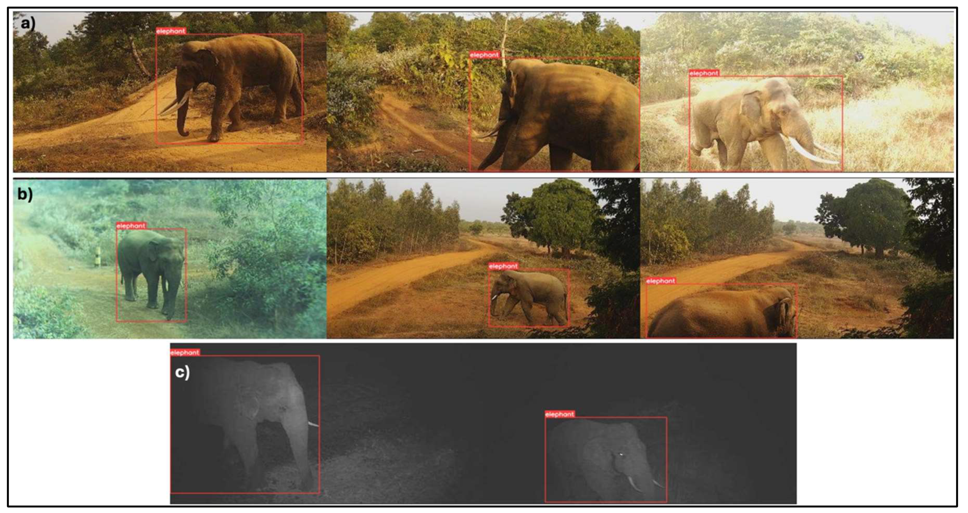
Figure 4.
a-l): The TrailGuard AI camera units installed in Jhargram forest division for four months detected and transmitted 266 elephant alerts in real time, including herds and lone bulls; 27.8% were day-time detections (4a-4f) and 72.2% of detections were at night (4g-4l).
Figure 4.
a-l): The TrailGuard AI camera units installed in Jhargram forest division for four months detected and transmitted 266 elephant alerts in real time, including herds and lone bulls; 27.8% were day-time detections (4a-4f) and 72.2% of detections were at night (4g-4l).
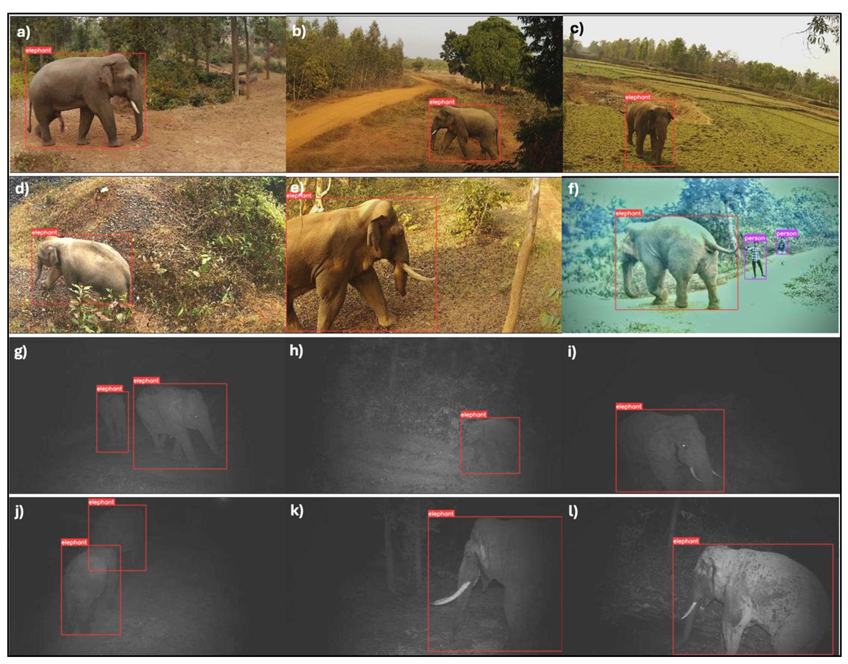
Figure 5.
Detection and transmission of number of elephant alerts across the 30 sites where TrailGuard AI systems were installed in the study area. The sites marked in red denote the hotspots of maximum elephant detections across this multi-use landscape. The effective study area also includes around 300 Joint Forest Management Committees (JFMCs) equivalent to the number of villages.
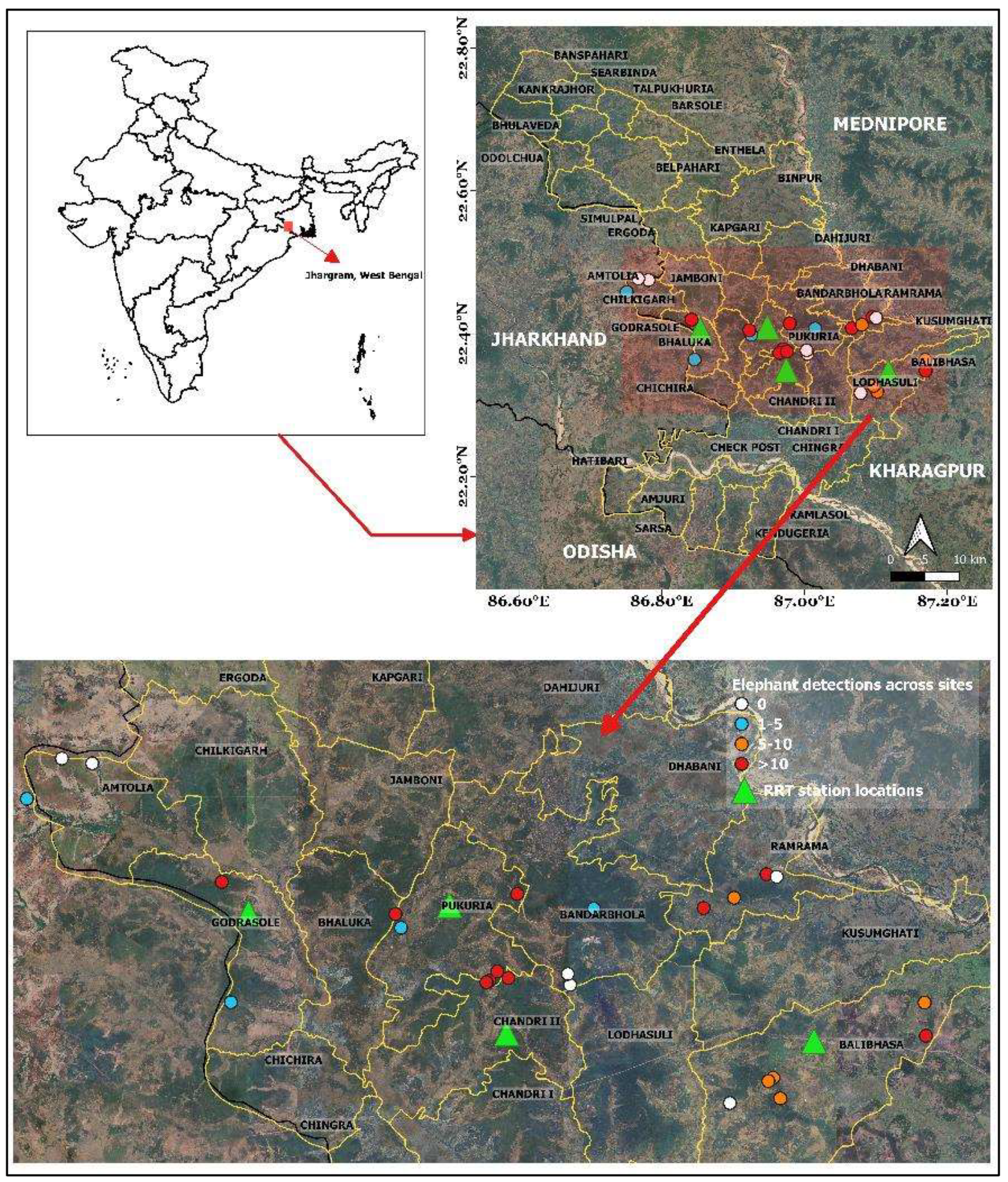
Figure 6.
a-e: Bar plots depicting the real-time alerts of elephants: a) partitioned by day and night; b) as classified by three group types—lone bulls, small groups (2-10 individuals), and herds (>10 individuals); c) distributed by time of day and group type; d) number of human detections across six forest beats (shown as an example); and e) for comparison, elephant detections partitioned by group type across the same forest beats as in (6d).
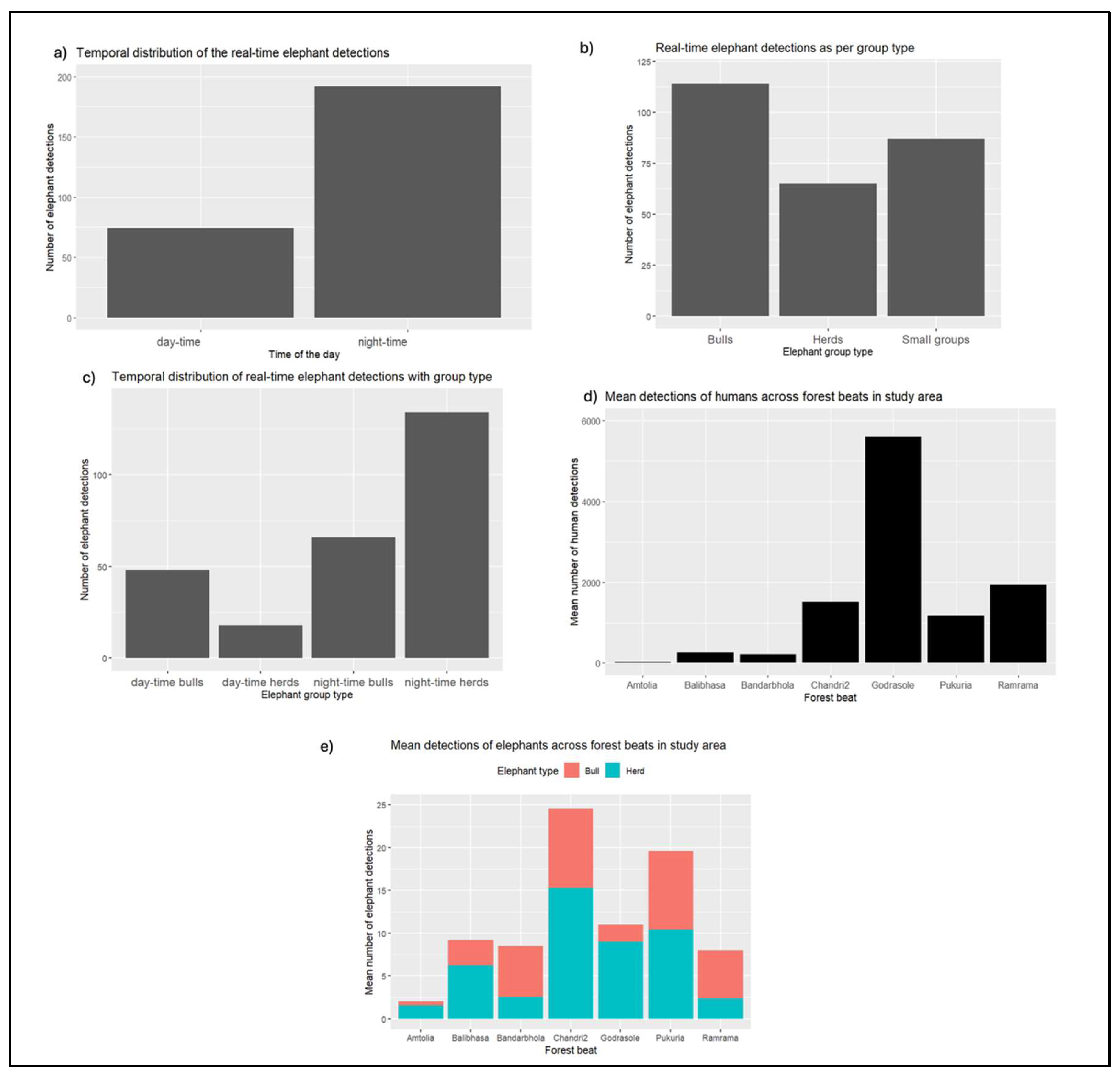
Elephant detection and group type varied by time-of-day across all sites (Figure 6a-c). We recorded 27.8% (n=74) of the elephant detections during daytime and nearly 72.2% (n=192) during nighttime when human movement along trails decreased (Figure 6a). Most detections were of lone bulls (n=114), followed by nearly equal numbers of small groups (n=87) and large herds (n=65) (Figure 6b). Elephant groups (both small and large herds combined) were predominantly detected after sunset hours (n=134; 88.2%) compared to during daytime (n=18; 11.8%). In contrast, 42.1% (n=48) of the detections of lone bulls occurred during daytime and the remaining 57.9% (n=66) occurred during nighttime (Figure 6c).
Integration of AI-Based Real-Time Alerts into Existing Protocols to Facilitate Rapid Response
The mean interval for RRTs responding to the real-time elephant alerts was 18.2 minutes (SD = 12.4 minutes, Range = 6-31 minutes). Before deployment of TrailGuard, the response time to mitigate or prevent negative interactions in previous years ranged from one to five hours; slow dissemination of information from local communities to rangers essentially precluded preventative measures taken by RRTs. The average distance of RRT stations from the TrailGuard deployment site was measured as 3.5 km and estimate of distance traversed by elephants in multi-use landscapes, beyond the boundaries of protected areas was estimated to be 1-3 km/18.2 min (Srinivasaiah et al. 2012). Based on these variables, we determined the AESR to be a radial distance of 4-5 km around the site where the TrailGuard AI camera-alert system was installed.
RRTs responded to 40% of the elephant alerts within the AESR; these interventions occurred where there was a clear indication that elephants were approaching village boundaries. For 60% of the alerts within the AESR, rangers discerned by location and the direction of elephant movement that the individual or herd was transitioning between forest patches and avoiding village areas, and that no field intervention was necessary.
Effect of the Technology on Reduction in Loss of Human Life and Injuries
Before the deployment of TrailGuard AI, one human death three human injuries were reported between October 2021 and April 2022 in the four ranges that formed the core study area. Three human deaths and two injuries were reported over the same period for 2022-23. In comparison, after the deployment of TrailGuard AI, no human deaths and injuries were reported from the same period in 2023-2024 in the Area of Effective Surveillance and Response (AESR).
Re-Identification and Comparative Costs of Mitigation
We identified 7-12 unique individual males using the study area; including recapture of three bulls on multiple occasions (Figure 7a-c). We estimated that to deploy 100 camera systems strategically across the known hotspots of elephant activity (along hotspots of incursions for bulls and matriarch herds) to monitor general movement patterns would incur a one-time cost of $50,000. This cost compares roughly to the total cost of capturing and radio-collaring conflict-prone lone bulls in the Indian context (@$48,000 for two elephants of the identified 7-12 lone bulls in this study).
Discussion
The Role of AI-Based, Real-time Alerts, and Rapid Response in Reducing Human-Elephant Conflict
Detections in this study represent the first-ever edge-based, AI-filtered, real-time alerts of wild Asian elephants and suggest a role for innovative approaches to prevent conflict. First, by receiving alerts in under a minute and obtaining the direction of movement of the individual(s), rapid response teams gained the situational awareness to determine where interventions were needed and, as importantly, where a response was deemed unnecessary, thus saving on resources. Second, the ability to distinguish lone bulls from herds and monitoring their movements allowed field officials to allocate resources more effectively. RRTs initiated measures such as blocking trails and forest roads from human use until elephants crossed to the adjacent forest or were scared away using loud noises of human groups. It would be useful in future studies to include the cost of installing and maintaining these approaches to augment the early detection.
Third, and of utmost importance, there were no injuries or fatalities in the six months within the Area of Effective Surveillance and Response (AESR) when the TrailGuard AI system was in the field compared to five injuries and four deaths in the previous two years in the same locations. Fourth, the real-time alerting system effectively reduced the delay between the appearance of elephants in village areas and when rangers received reports, a reduction from 4-5 hours to an average of 18 minutes. Fifth, by adding three layers of alerts—from the senior forest department officials to the forest beat-level office—a method for improved transparency was introduced to track the response of forest department staff. Finally, the capability of the system to filter out transmission of virtually all images of humans, in this use-case where transmission of humans was deemed a distraction, saved greatly on battery life. This filtration bodes well for use of this technology in countries where transmission of images of humans, even to designated end-users such as park officials, is prohibited by law.
Introduction of this technology and assigning experienced forest department field staff to RRTs, however, added new line items to existing protection budgets. These additional expenditures are summarized in this study, but the comparisons suggest several advantages over previous approaches in dealing with HEC: 1) it is far more cost-effective to strategically place a large number of inexpensive camera-alert systems to detect elephants approaching villages than it is to capture and fix satellite-collars to many young bull individuals that are prone to conflict, the latter cost being exorbitantly high per individual (Natarajan et al. 2023); 2) the time required for approval for capture and collaring bull elephants—which can range from a few weeks up to 1.5 years—is logistically prohibitive compared to the time required for permission to place camera-alert systems in the field (Natarajan et al. 2023); 3) Recent research and our results here have found that elephant conflict originates from concentrated areas in the landscape such as forest patches (i.e., “staging areas”) and on trails (Hahn et al. 2022). A sufficient density of strategically located camera-alert systems can both monitor staging areas before movement into villages or buffer zones and maintain an image dossier of “problem” bull elephants, monitor their movements, and trigger rapid response to anticipate their movements; and 4) the compensation costs for loss of human life could equal the cost of covering a large area of the forest-village interface with sensors to prevent encounters and also to provide early alerts of elephants entering croplands.
The loss of human life due to HEC effectively reverses progress towards fostering coexistence. First, the forest department receives a negative image and press after fatalities. Second, conservation of elephants becomes a more distant objective. To partially compensate for losses, in India, an average of $12,000 is paid out for a human fatality and permanent incapacitation, and $2,400 for severe injuries (Ministry of Environment, Forest and Climate Change: India, 2023). But loss of human life can never be adequately compensated, as fatal HEC encounters create numerous demographic orphans. Thus, the potential loss of human life and property could be equivalent in compensation paid to multiple times the operating cost of the alerting system and rapid response teams. But it is not only cost of elephant conservation that is reduced; these less visible issues can be addressed through smart implementation of technology.
Another important dimension of the study was the assessment of stakeholders. Perhaps the most supportive data came directly from the prime stakeholder, the WBFD: Although the official collaboration ended in March, 2024, the technology was deemed sufficiently effective that department officials requested to keep the system in operation indefinitely. Furthermore, the 40 villagers polled (representing communities from 80% of the forest beats where TrailGuard AI was deployed (Figure S3, Appendix A4)), unanimously supported the deployment of the technology as an early warning system. They highlighted the importance of real-time information of elephant presence and movements to minimize the potential of negative interactions. Community members also recommended the deployment of additional units in other remote parts of forest-village boundaries used by elephants but not currently covered by the technology. Local communities also requested notification of all elephant alerts in real time along with the RRTs. Even if informed of elephant movements in real time, however, only 20% of respondents (n=8) supported an increase in elephant populations in Jhargram, whereas the remainder were against increased numbers.
The role of India’s Wildlife Landscapes for Testing New Technologies to Prevent HWC
India’s natural landscapes that reconcile human welfare and conservation of charismatic large mammals also suffers relatively high levels of human-wildlife conflict (HWC). India holds 60% each of the world’s population of tigers and elephants, more than all other Asian nations combined. The problems of human-wildlife conflict are particularly acute and generate national news when human fatalities occur, such as from train collisions with elephants, wildlife-related human deaths and livestock depredations by charismatic large carnivores. A companion statistic offers insights to the increased challenges to protect villagers: 112 people were killed by tigers in India and 605 people killed by elephants in 2022 (Choubey, 2023). The challenges are exacerbated due to high rural population densities bordering tiger and elephant reserves and the large numbers of subsistence farmers whose crops and livestock are subject to depredation by wildlife (Dertien et al. 2023). Thus, there is great urgency to minimize this problem while continuing the remarkable recovery of endangered large mammal populations in India—a rewilding—that India has witnessed over the past 15 years. The TrailGuard AI technology is one such example that serves as a force multiplier for forest rangers assigned to cover large areas where wide-ranging mammals such as elephants and tigers roam through buffer zones that include villages (Dertien et al. 2023).
Other new applications of existing technologies, such as using thermal cameras along rail lines, offer promise to reduce collisions with elephants initiated by Tamil Nadu Forest Department (Thomas, 2024). In India, the embrace of camera-trap technology and drones to monitor endangered wildlife occurs at scales that exceed most countries in terms of investment and level of effort as witnessed by the all-India tiger census using thousands of camera traps (Qureshi et al. 2023). The key to successful scaling of these technologies will be largely determined by three features: low cost, ease-of-use, and durability.
Another feature that makes experimenting with new alerting technologies in India more advantageous compared to other countries is the excellent 4G coverage close to villages. This infrastructure contrasts with many areas in rural African settings where elephant populations abut remote villages. But cell coverage is spreading globally at the forest/village interface, and adopting solutions, such as pioneered in Jhargram, West Bengal, could have greater uptake elsewhere. Good cell coverage greatly reduces response time and is easier to deploy than are other communications systems where cell service is lacking. In border areas lacking cell service, TrailGuard AI offers alternative transmission protocols but these add several minutes to response time.
Coexistence as a Prerequisite for Rewilding
Where elephant populations have recovered from episodes of ivory poaching due to enhanced surveillance, crime investigation, and prosecution of habitual offenders, there is a paradigm shift in the focus from intensive protection to managing conflict and preventing retaliation (Graham et al. 2009; Gubbi et al. 2014; Goswami & Vasudev, 2017). Although 5% of India is covered by protected areas, single reserves are often not large enough to support viable populations of large area-sensitive mammals, which would require a metapopulation approach to conservation by facilitating dispersal. This finding is as true for tigers as it is for elephants across their entire range (Wikramanayake et al. 2011). For elephants and other wide-ranging large mammal species occupying landscapes that encompass multiple-use areas, human habitations, and agricultural areas, it is essential that corridors connecting source and satellite populations receive formal protection. In this regard, working closely with local communities to foster coexistence with wildlife is key to facilitate dispersal and recolonization of former habitats (Vasudev et al. 2023). Huang et al. (2024) showed that the stabilization of elephant populations in southern and eastern Africa was in part due to the presence of wildlife corridors that allowed elephants to disperse. The AI-based monitoring technology that we presented can also be used to monitor elephant movements through regional and local corridors. For example, in our study area, the elephants in the Jhargram forest division move into the neighboring states of Jharkhand to the west and Odisha to the south multiple times per year (Figure S1, Appendix A1) (Singh et al. 2023). The same phenomenon is true in other strongholds of the Asian elephant’s range in India and regionally where important forest reserves occur along state or national boundaries and elephants move across them (e.g., transboundary movement across Nepal and India (Naha et al. 2019; Ram et al. 2023)).
Encouraging local guardianship of elephant corridors and conservation requires strong outreach initiatives between local forest departments and community leaders (Zimmerman et al. 2009). In this regard, incentive programs to promote movements of elephants and other large mammals could be encouraged (Dinerstein et al. 2013; Badola et al. 2021; Kamdar et al. 2022). Innovative and carefully conceived initiatives and experiments, such as in the state of Assam, where local communities, in collaboration with the state forest department, have organized to plant palatable forage for elephants along the interface of the protected area and village boundaries, has presumably helped minimize crop loss, although this phenomenon requires further documentation. This intervention combines planting fruit-bearing trees in the buffer zones and paddy fields kept explicitly for elephants to feed upon in widely used corridors. This approach could be replicated elsewhere if proven successful (Hati Bondhu, n.d.). Ideally, a suite of habitat management interventions essential to providing palatable forage for elephants may be required in the study area of Jhargram forests as well which are otherwise dominated by sal monoculture.
Under difficult circumstances of exponential growth of the human population (surpassing China) and infrastructural development, it is remarkable that the numbers of tigers in India have doubled in the past ten years and wild elephant numbers are holding steady (Pandey et al. 2024). Here, a cultural and religious basis for tolerance—elephants as a reincarnation of the Hindu God, Ganesh—bestows a sense of reverence to many devout villagers. Such factors at work in India may not be easily replicated in other countries. Regardless, AI technology, when applied appropriately to achieve a social good, can have great benefit for people and elephants. The ability of AI algorithms to detect the most common conflict-prone species and send real-time alerts, as shown in this study, offers great promise for a future of coexistence and rewilding in other regions of the world.
Acknowledgments
We thank the staff of the West Bengal Forest Department and JICA for making this project possible. Special thanks to the Divisional Forest Officer, Additional Divisional Forest Officer, and Range Officers from the Jhargram Forest Division for their field work support, and to residents and village groups for their participation and knowledge sharing. We acknowledge Mohit Khillari, Goutam Rana, Harish, and others for their valueable assistance in deploying the TrailGuard camera system. Funding for this project was provided by JICA, with support from the Amar Foundation, SeaDream Foundation, and the Weeden Family Foundation. We also thank C. Vynne, N. R. Hahn, S. Pimm, C. Thouless, L. King, and N. Lakshminarayanan for manuscript comments.
Authors’ Biographical Information
Sankarshan Rastogi (sankarshan.rastogi@gmail.com) is Research Scientist, Piyush Yadav is CEO, H. S. Negi is Senior Advisor, and Wajid Ali Shah is Business Manager of Nightjar Technologies in India. Sumana Bhattacharya is Chief Conservator of Forests and Project Director, and Kumar Vimal is Conservator of Forests for the West Bengal Forest Department, Government of West Bengal, India. Eric Dinerstein is the CEO of Nightjar and Senior Biodiversity Advisor at RESOLVE in Washington, DC. Andy T.L. Lee is Enterprise Development Manager at Nightjar and Senior Program Associate at RESOLVE. Steve Gulick is the inventor of TrailGuard AI and Chief Innovation Officer at Nightjar. Yushi Nagano is Senior Digital Officer, and Sasaki Hirari is Country Officer, South Asia Department for Japan International Cooperation Agency in Tokyo, Japan.
References
- Anoop, N. R., Krishnan, S., & Ganesh, T. (2023). Elephants in the farm–changing temporal and seasonal patterns of human-elephant interactions in a forest-agriculture matrix in the Western Ghats, India. Frontiers in Conservation Science, 4, 1142325.
- Badola, R., Ahmed, T., Gill, A. K., Dobriyal, P., Das, G. C., Badola, S., & Hussain, S. A. (2021). An incentive-based mitigation strategy to encourage coexistence of large mammals and humans along the foothills of Indian Western Himalayas. Scientific Reports, 11(1), 5235.
- Banerjee, S., & Aiyadurai, A. (2022). ‘Everyday conservation’: a study of actors and processes in an elephant conservation project in Assam, India. Human Dimensions of Wildlife, 27(6), 536-553.
- Blackwell, B.F., DeVault, T.L., Fernandez-Juricic, E., Gese, E.M., Gilbert-Norton, L., Breck, S.W., (2016). No single solution: application of behavioural principles in mitigating human–wildlife conflict. Anim. Behav. 120, 245–254. [CrossRef]
- Chandramouli, C., & General, R. (2011). Census of india 2011. Provisional Population Totals. New Delhi: Government of India, 409-413.
- Chen, P., Gao, Y., Lee, A. T., Cering, L., Shi, K., & Clark, S. G. (2016). Human–carnivore coexistence in Qomolangma (Mt. Everest) nature reserve, China: patterns and compensation. Biological Conservation, 197, 18-26.Choubey, A.K. (2023). Response to unstarred question no. 06 in Lok Sabha. Ministry of Environment, Forest & Climate Change, Government of India.
- DeMotts, R., & Hoon, P. (2012). Whose elephants? Conserving, compensating, and competing in northern Botswana. Society & Natural Resources, 25(9), 837-851.
- Denninger-Snyder, K., Mneney, P., Benjamin, B., Mkilindi, P., Mbise, N., 2019. Seasonal and spatial vulnerability to agricultural damage by elephants in the western Serengeti, Tanzania. Oryx 1–11. [CrossRef]
- Dertien, J.S., Negi, H., Dinerstein, E., Krishnamurthy, R., Negi, H.S., Gopal, R., Gulick, S., Pathak, S.K., Kapoor, M., Yadav, P. and Benitez, M., (2023). Mitigating human–wildlife conflict and monitoring endangered tigers using a real-time camera-based alert system. BioScience, 73(10), pp.748-757.
- Dinerstein, E., Varma, K., Wikramanayake, E., Powell, G., Lumpkin, S., Naidoo, R., Korchinsky, M., Del Valle, C., Lohani, S., Seidensticker, J. and Joldersma, D. (2013). Enhancing conservation, ecosystem services, and local livelihoods through a wildlife premium mechanism. Conservation Biology, 27(1), pp.14-23.
- Fernando, P., Kumar, M. A., Williams, A. C., Wikramanayake, E., Aziz, T., & Singh, S. M. (2008). Review of human-elephant conflict mitigation measures practiced in South Asia (pp. 19-20). Gland, Switzerland: WWF. W: Gland, Switzerland.
- Goodyear, S. E. (2015). Habituation to auditory stimuli by captive African elephants (Loxodonta africana).
- Goswami, V. R., Vasudev, D., & Oli, M. K. (2014). The importance of conflict-induced mortality for conservation planning in areas of human–elephant co-occurrence. Biological Conservation, 176, 191-198.
- Goswami, V. R., & Vasudev, D. (2017). Triage of conservation needs: the juxtaposition of conflict mitigation and connectivity considerations in heterogeneous, human-dominated landscapes. Frontiers in Ecology and Evolution, 4, 144.
- Graham, M. D., Douglas-Hamilton, I., Adams, W. M., & Lee, P. C. (2009). The movement of African elephants in a human-dominated land-use mosaic. Animal conservation, 12(5), 445-455.
- Gross, E. M., Lahkar, B. P., Subedi, N., Nyirenda, V. R., Klebelsberg, E., & Jakoby, O. (2021). Elephants in the village: Causes and consequences of property damage in Asia and Africa. Conservation Science and Practice, 3(2), e343.
- Gross, E. M., Pereira, J. G., Shaba, T., Bilério, S., Kumchedwa, B., & Lienenlüke, S. (2022). Exploring routes to coexistence: developing and testing a human–elephant conflict-management framework for African elephant-range countries. Diversity, 14(7), 525.
- Guarnieri, M., Kumaishi, G., Brock, C., Chatterjee, M., Fabiano, E., Katrak-Adefowora, R., Larsen, A., Lockmann, T.M. and Roehrdanz, P.R. (2024). Effects of climate, land use, and human population change on human–elephant conflict risk in Africa and Asia. Proceedings of the National Academy of Sciences, 121(6), p.e2312569121.
- Gubbi, S. (2012). Patterns and correlates of human–elephant conflict around a south Indian reserve. Biological Conservation, 148(1), 88-95.
- Gubbi, S., Swaminath, M. H., Poornesha, H. C., Bhat, R., & Raghunath, R. (2014). An elephantine challenge: human–elephant conflict distribution in the largest Asian elephant population, southern India. Biodiversity and conservation, 23, 633-647.
- Guru, B. K., & Das, A. (2021). Cost of human-elephant conflict and perceptions of compensation: evidence from Odisha, India. Journal of Environmental Planning and Management, 64(10), 1770-1794.
- Hahn, N.R., Wall, J., Denninger-Snyder, K., Goss, M., Sairowua, W., Mbise, N., Estes, A.B., Ndambuki, S., Mjingo, E.E., Douglas-Hamiliton, I. and Wittemyer, G., (2022). Risk perception and tolerance shape variation in agricultural use for a transboundary elephant population. Journal of Animal Ecology, 91(1), pp.112-123.
- Hati Bondhu. (n.d.). The Elephant Habitat Enrichment Program. https://hatibondhu.org.
- Huang, R. M., Maré, C., Guldemond, R. A., Pimm, S. L., & Van Aarde, R. J. (2024). Protecting and connecting landscapes stabilizes populations of the Endangered savannah elephant. Science Advances, 10(1), eadk2896.
- Jadhav, S., & Barua, M. (2012). The Elephant Vanishes: Impact of human–elephant conflict on people's wellbeing. Health & place, 18(6), 1356-1365.
- Kamdar, A., Baishya, H. K., Nagendra, H., Ratnam, J., Smith, D., & Sekar, N. (2022). Human–elephant conflict mitigation as a public good: what determines fence maintenance? Ecology and Society, 27(3).
- King, L. E., Lala, F., Nzumu, H., Mwambingu, E., & Douglas-Hamilton, I. (2017). Beehive fences as a multidimensional conflict-mitigation tool for farmers coexisting with elephants. Conservation Biology, 31(4), 743-752.
- Matsuura, N., Nomoto, M., Terada, S., Yobo, C. M., Memiaghe, H. R., & Moussavou, G. M. (2024). Human-elephant conflict in the African rainforest landscape: crop-raiding situations and damage mitigation strategies in rural Gabon. Frontiers in Conservation Science, 5, 1356174.
- Mayberry, A. L., Hovorka, A. J., & Evans, K. E. (2017). Well-being impacts of human-elephant conflict in Khumaga, Botswana: exploring visible and hidden dimensions. Conservation and Society, 15(3), 280-291.
- Mekonen, S. (2020). Coexistence between human and wildlife: the nature, causes and mitigations of human wildlife conflict around Bale Mountains National Park, Southeast Ethiopia. BMC ecology, 20(1), 51.
- Ministry of Environment, Forest & Climate Change: Project Tiger & Elephant Division, Government of India (2023, September 4). Proceedings of the 19th Project Elephant Steering Committee Meeting held on 12th August 2023 at Bhubaneshwar, Odisha. https://moef.gov.in/wp-content/uploads/2023/11/PE-Proceeding-19th-Steering-Committee-of-Project-Elephant.pdf.
- Naha, D., Sathyakumar, S., Dash, S., Chettri, A., & Rawat, G. S. (2019). Assessment and prediction of spatial patterns of human-elephant conflicts in changing land cover scenarios of a human-dominated landscape in North Bengal. PloS one, 14(2), e0210580.
- Natarajan, L., Nigam, P., & Pandav, B. (2023). Impacts of passive elephant rewilding: assessment of human fatalities in India. Environmental Conservation, 50(3), 186-191.
- Nayak, M., & Swain, P. K. (2022). From fear to festivity: Multi-stakeholder perspectives on human-elephant conflict and coexistence in India. Journal of Public Affairs, 22(2), e2496.
- Nelson, A., Bidwell, P., & Sillero-Zubiri, C. (2003). A review of human-elephant conflict management strategies. People & Wildlife, A Wildlife Conservation Research Unit, Born Free Foundation Partnership.
- Neupane, B., Budhathoki, S., & Khatiwoda, B. (2018). Human-elephant conflict and mitigation measures in Jhapa District, Nepal. Journal of Forest and Livelihood, 16(1), 103-112.
- Pandey, R. K., Yadav, S. P., Selvan, K. M., Natarajan, L., & Nigam, P. (2024). Elephant conservation in India: Striking a balance between coexistence and conflicts. Integrative Conservation.
- Project Elephant, Government of India. (2020) Status and distribution of elephants in India. New Delhi, India: Ministry of Environment, Forest, and Climate Change, Government of India.
- Qureshi, Q., Jhala, Y. V., Yadav, S. P., & Mallick, A. (eds) (2023). Status of tigers, co-predators and prey in India, (2022). National Tiger Conservation Authority, Government of India, New Delhi, and Wildlife Institute of India, Dehradun.
- R Core Team (2023). R: A language and environment for statistical computing. R Foundation for Statistical Computing, Vienna, Austria. URL https://www.R-project.org/.
- Ram, A.K., Yadav, N.K., Subedi, N., Pandav, B., Mondol, S., Khanal, B., Kharal, D.K., Acharya, H.B., Dhakal, B.K., Acharya, K.P. and Baral, H.S. (2022). Landscape predictors of human elephant conflicts in Chure Terai Madhesh Landscape of Nepal. Environmental Challenges, 7, p.100458.
- Sampson, C., McEvoy, J., Oo, Z.M., Chit, A.M., Chan, A.N., Tonkyn, D., Soe, P., Songer, M., Williams, A.C., Reisinger, K. and Wittemyer, G. (2018). New elephant crisis in Asia—Early warning signs from Myanmar. PLoS One, 13(3), p.e0194113.
- Schaffer, L.J., Khadka, K.K., Van Den Hoek, J., Naithani, K.J., (2019). Human-Elephant Conflict: A Review of Current Management Strategies and Future Directions. Front. Ecol. Evol. 6, 235. [CrossRef]
- Singh, A., Kumara, H. N., Mahato, S., & Velankar, A. D. (2023). Anthropogenic driven range expansion of Asian elephant Elephas maximus in an agricultural landscape and its consequences in South West Bengal, India. Journal for Nature Conservation, 73, 126374.
- Srinivasaiah, N. M., Anand, V. D., Vaidyanathan, S. & Sinha, A. (2012). Usual populations, unusual individuals: Insights into the behavior and management of Asian elephants in fragmented landscapes. PLoS ONE 7, e42571.
- Terada, S., Yobo, C. M., Moussavou, G. M., & Matsuura, N. (2021). Human-elephant conflict around Moukalaba-Doudou National Park in Gabon: Socioeconomic changes and effects of conservation projects on local tolerance. Tropical Conservation Science, 14, 19400829211026775.
- Thomas, W. (2024). “Trial run of AI-based early warning system near Coimbatore proves promising as field staff save elephants”, The Hindu, 7 January, 2024.
- Vasudev, D., Fletcher Jr, R. J., Srinivas, N., Marx, A. J., & Goswami, V. R. (2023). Mapping the connectivity–conflict interface to inform conservation. Proceedings of the National Academy of Sciences, 120(1), e2211482119.
- Wakoli, E. N., & Sitati, N. (2012). Analysis of temporal and distribution patterns of elephant attacks on humans and elephant mortality in Transmara District, Kenya. Greener Journal of Environment Management and Public Safety, 1(1), 27-37.
- Williams, C., Tiwari, S.K., Goswami, V.R., De Silva, S., Kumar, A., Baskaran, N., Yoganand, K. and Menon, V. (2020). Elephas maximus. The IUCN red list of threatened species 2020: e. T7140A45818198. Retrieved, 12, p.2021.
- Wikramanayake, E., Dinerstein, E., Seidensticker, J., Lumpkin, S., Pandav, B., Shrestha, M., Mishra, H., Ballou, J., Johnsingh, A.J.T., Chestin, I. and Sunarto, S., (2011). A landscape-based conservation strategy to double the wild tiger population. Conservation Letters, 4(3), pp.219-227.
- Woodroffe, R., Thirgood, S., Rabinowitz, A., 2005. People and Wildlife, Conflict or Co-existence? Cambridge University Press, Cambridge. [CrossRef]
- Zimmermann, A., Davies, T. E., Hazarika, N., Wilson, S., Chakrabarty, J., Hazarika, B., & Das, D. (2009). Community-based human-elephant conflict management in Assam. Gajah, 30, 34-40.
Figure 1.
Spatial distribution of wild Asian elephant populations (orange polygons) distributed among 24 states in India (data from Government of India’s 2017 Elephant population census). The study area in the state of West Bengal, the Jhargram forest division, bordering the state of Jharkhand, is shown in the inset map.
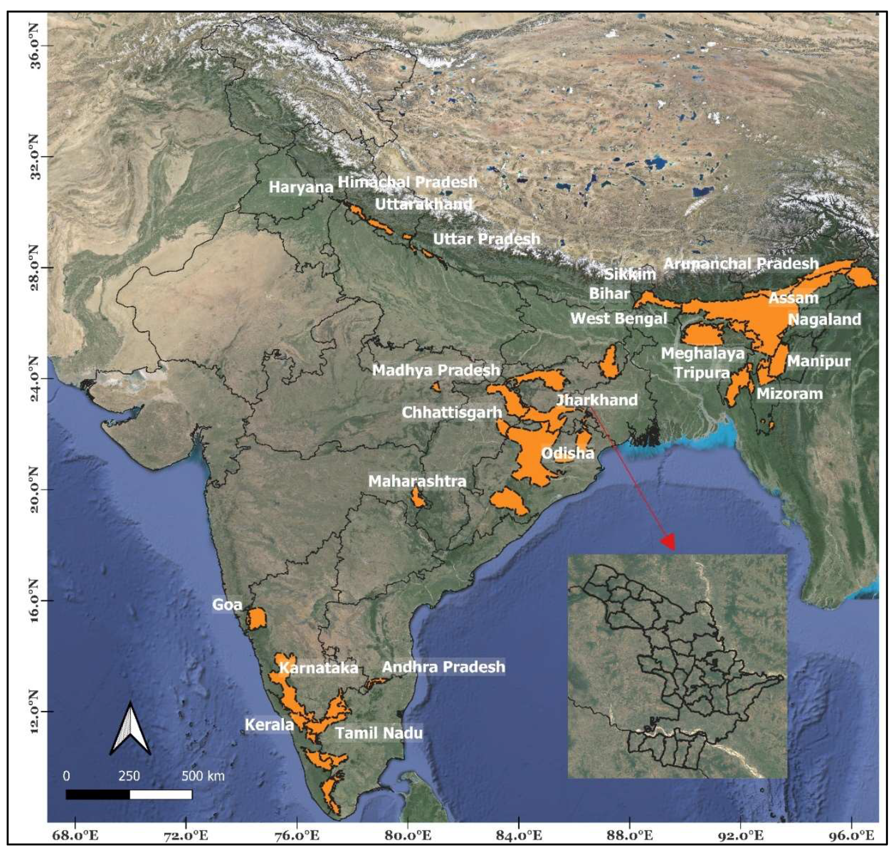
Figure 2.
Schematic describing the process from first detection of the species of interest (here, an elephant) to the filtering by AI models at two levels (i.e., at the edge and subsequently on the server) and transmission of images in real time to recipients. A “beat” is the Indian Forest Department’s smallest management unit.
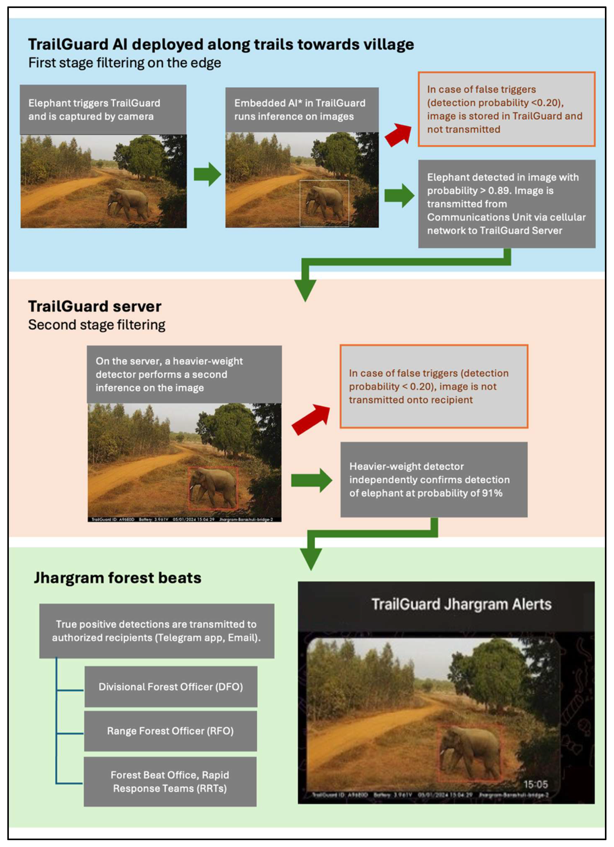
Figure 3.
a-h: Various output classes detected and filtered by the edge detector (AI model) in a multi-use landscape in the Jhargram Forest Division. To minimize alerts received by the Rapid Response Teams to elephants, frequent detections of humans on foot, riding bicycles, or traveling on motorcycles were not transmitted [a-c] but were instead recorded for future analysis on storage media (Appendix 1). Similarly, frequent detections of domestic livestock [d,f], or less frequently, native wildlife such as wild boar [e] and peninsular wolves [g], were recorded, but not transmitted. (These features are customizable by the end user).
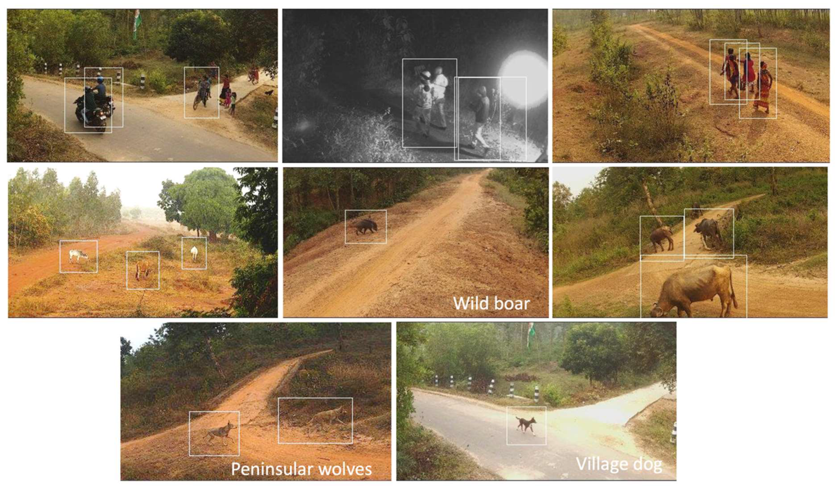
Figure 7.
a-c: Three lone bull elephants were re-identified at multiple sites. The re-identification was aided by key distinguishing body features: a) long tusks (Bull 1); b) distinct forehead (Bull 2); and c) a single tusk (Bull 3). Body features such as ear-folds, broken tusks, forehead shape, cuts due to infighting between individuals, and other features assisted in separation of individuals.
Disclaimer/Publisher’s Note: The statements, opinions and data contained in all publications are solely those of the individual author(s) and contributor(s) and not of MDPI and/or the editor(s). MDPI and/or the editor(s) disclaim responsibility for any injury to people or property resulting from any ideas, methods, instructions or products referred to in the content. |
© 2024 by the authors. Licensee MDPI, Basel, Switzerland. This article is an open access article distributed under the terms and conditions of the Creative Commons Attribution (CC BY) license (http://creativecommons.org/licenses/by/4.0/).
Copyright: This open access article is published under a Creative Commons CC BY 4.0 license, which permit the free download, distribution, and reuse, provided that the author and preprint are cited in any reuse.


