

Submitted:
11 April 2024
Posted:
15 April 2024
You are already at the latest version
Abstract
This study analyses the changes in land use in the Sado estuary (West-Central Portugal) based on a multitemporal analysis of cartographic data from the 19th century and remote sensing land use maps from the 21st century, updated by field work. A GIS plotting of land-use evolution is summarized in a quantitative table. The comparison shows the changes in land use, with increasing occupation by human economic activities, including extensive agriculture and forestry, as well as localized urbanization and industrialization. The main elements of the landscape impacted by anthropogenic uses were: i) hydrography - river dams affected the flow dynamics and sedimentary processes in the estuary; ii) vegetation – increasing agriculture and forestry reduced the areas of native vegetation, nowadays mostly occupied by vineyards, pine forests and cork oaks. iii) wetlands - tidal and alluvial plains are being occupied by rice cultivation, aquaculture, industries, and ports; iv) coastal dunes – new developments are occupying large areas of Holocene coastal dunes; v) natural environment – mining and dredging affected some habitats and biodiversity. This analysis is intended to help the territorial organization of present and future economic activities, as well as to reduce environmental and social problems, promoting long-term sustainability of this rapidly evolving region.
Keywords:
land use
; multi-temporal analysis
; geoprocessing
; environmental impacts
; Sado estuary
1. Introduction
The Human groups have always recognized soil and water as essential natural resources to ensure food, shelter, and the development of economic activities. Environmental studies addressing the use and occupation of land by human societies include the analysis of the state of biotic and abiotic components of the landscape - vegetation, mineral resources, soils, slopes, hydrographic network, and fauna. As societies succeed each other in occupying a certain space, their relationship with nature also changes according to economic and social interests and the space itself undergoes transformations.
Multi-temporal analysis of land use through geoprocessing techniques serves as an auxiliary tool for monitoring and evaluating urban expansion and economic activities in the territory. Remote sensing becomes important for identifying changes in the landscape and the state of its natural resources, while offering cartographic documents revealing environmental changes on different scales - local, regional, and global. By integrating the information from these analyses, it is possible to understand the consequences of environmental problems affecting the territory - climate change, soil degradation, water scarcity and contamination, among others.
Witt such territorial data, local and public agencies can develop plans for land use planning and management, defining actions for the rational and sustainable use of natural resources, to ensure the well-being and maintenance of current and future generations.
In different countries, researchers have studied land use and occupation using satellite images and geoprocessing techniques for various purposes: understanding the impacts on natural resources, proposing mitigation measures for environmental problems, monitoring desertification processes in certain regions, identifying areas under anthropogenic pressure, selecting ecological zones for conservation, and supporting sustainable environmental planning and management [1,2,3,4,5,6,7,8].
Anthropogenic pressure resulting from land use and occupation produces changes in systemic relationships among environmental components, with evident impacts on natural resources. In 1987, the World Commission on Environment and Development produced the document "Our Common Future," an agenda that pointed out the need for adopting actions to reduce nature degradation [9]. Hence, the concept of sustainable development emerged, understood as using natural resources to meet the needs of current generations, while ensuring the conservation of these resources to meet the needs of future generations. Therefore, it suggests the adoption of an economic model that harmonizes development and conservation of natural resources.
Following "Our Common Future," numerous international conferences ensued, establishing protocols and agendas with representatives of nations to reduce impacts on environmental resources and biodiversity. The Rio-92 (United Nations Conference on Environment and Development) established Agenda 21 and promoted the concept of sustainable development, which should be incorporated into planning projects of all sectors, emphasizing the conservation of natural resources [10].
Despite these initiatives, serious environmental problems are still observed in different regions of our planet. The use of satellite images and cartographic documents in the multi-temporal analysis of a region can guide actions towards environmental planning focusing on sustainability, indicating the need to harmonize economic development and conservation of environmental resources, as the continuity of humanity depends on these resources.
This paper presents a multi-temporal analysis of land use and occupation in the municipalities of the Sado Estuary, from the 19th to the 21st century, using maps and satellite images. This study aims to contribute to an improved environmental planning supporting a sustainable development.
2. Materials and Methods
This study is focused on the evolution of land use and occupation of the estuarine municipalities of Sado river, in West-central Portugal. Historical and recent cartographic documents, satellite images, and geoprocessing techniques were employed, using Geographic Information System (GIS) to identify changes occurring during the 19th to 21st centuries.
The spatial analysis of an area with GIS tools enables the observation of landscape transformations resulting from natural phenomena or induced by anthropogenic interventions. This approach helps in defining the management of the territory with the objective of reconciling economic development and environmental and social sustainability. Therefore, these techniques constitute important tools for sustainable environmental planning, enabling the prevention and monitoring of impacts on ecosystems.
To perform the multi-temporal comparative analysis, land use maps from the 19th and 21st centuries were developed. The 19th century land use was based on existing Agricultural Charts by Pery [11] - provided by the Directorate-General for Agriculture and Rural Development (DGADR). The different sheets were assembled, and subsequently, the cartogram was georeferenced, using the river channel and some localities to adjust the maps. The 21st century map was produced using the COS 2018 (Land Use and Occupation Chart) shapes available on the D-GTerritório website [12]. Both ancient and modern cartographic outputs were generated using Geographic Information System (GIS) techniques and the QGis 2.18 software.
Polygons were created and integrated to highlight the predominant land use types. Then, the maps were overlaid to analyze the evolution of changes in land use, those whose areas were expanded or decreased. The necessary adjustments to the maps resulted from the combination of satellite image interpretation and observations made during fieldwork. Thus, qualitative information based on the terrain topography characteristics and land use and cover were added to this analysis. Photographic records and checkings were also taken during field work in the area of the municipalities of the Sado estuary.
A table was compiled with information on the main types of land use represented in the 19th and 21st-century maps, indicating the occupied area, both in km² and percentage, to highlight changes occurring over the period.
Land use classes were defined and characterized based on the “Technical Specifications of the Land Use and Occupation Chart of Continental Portugal” with 7 classes - Artificial Surfaces; Agriculture and cultivable lands; Pasture; Agroforestry and forest area; Mixed Vegetation; Coastal Environments; and Coastal Wetlands [13]. The Materials and Methods should be described with sufficient details to allow others to replicate and build on the published results. Please note that the publication of your manuscript implicates that you must make all materials, data, computer code, and protocols associated with the publication available to readers. Please disclose at the submission stage any restrictions on the availability of materials or information. New methods and protocols should be described in detail while well-established methods can be briefly described and appropriately cited.
3. Results
3.1. Regional Characterization
The study area encompasses lands of four municipalities around the estuary of the Sado river, within the boundaries of the hydrographic basin - Setúbal, Palmela, Alcácer do Sal, and Grândola (Figure 1). The choice of this area is justified by its highly dynamic environment, where natural factors and phenomena interact, alongside with growing urban expansion and economic activities.
The downstream limit of the study area corresponds to the river mouth of the Sado, a line defined by the Portuguese Official Administrative Chart (CAOP), between the Tróia peninsula and the city of Setúbal. The upstream limit has been considered as the upper tip of the higher dynamic tides, situated about 15 km SE of the city of Alcácer do Sal [14].
The Sado hydrographic basin drains an area of 7,692 km², making it the largest entirely Portuguese basin. It is delimited to the north by the Tagus basin, to the east by the Guadiana basin, to the south by the Mira basin, and to the west by a coastal strip that drains directly into the sea [15]. The Sado river originates in Ourique, in the Serra da Vigia (230 high), and flows into the Atlantic Ocean, with a total length of 180 km. The estuary has a submerged area of approximately 200 km², corresponding to the estuarine basin and the submarine ebb delta [16].
The area falls within the Mediterranean temperate climate zone, with hot, dry summers and an average annual precipitation of around 600 mm [16]. Rainfall is concentrated in the autumn-winter period, with 60% of the annual volume, exceeding 70 mm/month from October to January.
The geological basement includes different lithologies and ages, from the Paleozoic to the Quaternary period predominate. The main river and its tributaries drain mostly Cenozoic terrigenous deposits of the Sado Basin [17]. This basin is bounded: I) to the north, by the Arrábida Mountain Range consisting of Mesozoic carbonate rocks; ii) to the east, by a morphological rise, marking the contact between the Cenozooic sedimentary rocks and the Paleozoic mostly metamorphic rocks of the South Portuguese Zone (SPZ) and the Ossa-Morena Zone (OMZ); iii) to the west, by the Atlantic Ocean, and iv) to the southwest, by the Grândola fault [15].
The geomorphology is characterized by a flat and gently undulating landscape, with a low gradient slope and very small elevations, except for the mountain ranges of Arrábida and Grândola. The predominant soils have a sandy texture due to the rocks and deposits that originated them.
Currently, according to the 2021 demographic census, the resident population in the municipalities corresponds to about 217 thousand inhabitants, engaged in rural and urban activities, port operations, industrial activities, agroforestry production, and tourism. Setúbal has the highest population density an both Setúbal and Palmela showed growth rates, while Alcácer do Sal and Grândola experienced a population decline in 2021, compared to the previous census.
3.2. Historical Land Use and Occupation
Land use and occupation patterns reveal how societies manage landscape and use its natural resources. Human interventions tend to produce imbalances or environmental impacts, proportional to their technological development.
Human presence around the Sado estuary dates back to the Mesolithic period [18]. Approximately 20 thousand years ago, global warming led to the melting of ice in the Northern Hemisphere, causing sea levels to rise and marine transgressions resulted in the flooding of lower river sectors, forming estuaries [19].
The mild Holocene temperatures favoured the migration of Mesolithic peoples to coastal regions. Due to ecological-geographical characteristics, the Sado estuary was occupied by these peoples, who lived in the area exploiting food resources [20]. Holocene climatic fluctuations in Portuguese territory modified the original land cover, particularly in the coastal region, where the sub-humid climate favoured the expansion of maritime pine forests (Pinus pinaster) and oak forests (Quercus) [21].
Chalcolithic shell middens have been found in the Sado valley and its tributaries on river terraces and at the base of slopes, indicating the occurrence of sea-level rise and occupation of the area between approximately 8400-7000 cal BP [18]. These peoples mainly lived of bivalve mollusk gathering, fishing, and hunting, and remained in this territory for about a thousand years.
Over time, other peoples inhabited the lands of the Sado river and estuary, including Romans, Moors, French, and others, interested in natural resources and/or their strategic geographical position. Archaeological studies have revealed the existence of Roman kilns dating from the 1st century BC to the 5th century AD, which produced amphorae in the locations of Abul and Herdade Pinheiro - Alcácer do Sal. The amphorae were intended for the industrial complex where fish salting was processed, in the Tróia peninsula [21]. Despite ancient occupation and use of natural resources in this area, these peoples did not cause significant environmental changes.
Salt production was developed in Setúbal and Alcácer do Sal since the Roman period. In the 16th century, salt pans were built in marsh areas along the banks of the Sado, mainly in Abul, Batalha, Faralhões, and Gâmbia. In the following century, the activity expanded to the Mitrena peninsula. Salt production played a prominent role in the Portuguese economy until the end of the 19th century, when it began to decline [22].
In the 19th-century map (Figure 2), the main types of land use and cover are represented. At that time, most of the territory was occupied by heaths and scrublands - typical xerophytic vegetation covering extensive plains. These protected the low-fertility sandy soils from erosive processes by adding organic matter.
Rice cultivation has been established in the district of Setúbal, particularly in Alcácer do Sal, since the 18th century [22]. By the end of the 19th century, rice and wheat, the predominant arable crops, thrived on the riverbanks. On the hill tops, historical documents also record the replacement of extensive areas of pine forests and heaths by extensive vineyards. Agroforestry use corresponded mainly to extensive "montados" of cork oak (Quercus suber) and holm oak (Quercus ilex), and to a lesser extent stone pine (Pinus pinea). This occupation occurred at the beginning of the Liberal Regime, the end of the 18th century, and the beginning of the 19th century [23]. At the time, favourable factors for their establishment were large private landholdings, cheap wage labor, and state support for the removal of native vegetation.
In the 19th century, cork oak “montados” dominated the territory of Grândola, Águas de Moura-Palmela, and Alcácer do Sal. Pine trees covered the central sector of the study area, and holm oaks predominated in areas with dryer climatic conditions (Figure 2). Saltpans dominated the plains affected by ocean tides, while rice cultivation developed in large plains flooded by river waters. In the northwest sector, in Palmela and Setúbal, horticultural crops and vineyards stood out, while in Alcácer do Sal, vineyards were intercropped with olive groves.
3.2. 21st Century Land Use and Occupation
Between the 19th century and the present day, the landscape of the Sado territory has undergone significant changes, with the emergence of new activities and the retraction of others. In this analysis, seven main classes of land use and cover were identified: 1) Artificial Surfaces - urban areas, industry, and commerce; 2) Agriculture and cultivable lands - viticulture, olive cultivation, rice cultivation, and mixed farming; 3) Pasture - native and planted forage; 4) Agroforestry and forest area - cork oak “montados”, holm oak, and pine trees; 5) Mixed Vegetation - agroforestry lands with different oak species and shrubs; 6) Coastal Environments - beaches and dune fields; 79 Coastal Wetlands - salt marshes, seagrass meadows, and intertidal zones (Figure 3). The expansion of the urbanization process in Setúbal is striking in this century, clearly influenced by its proximity to Lisbon, the country's capital. Setúbal and Palmela are part of the Lisbon Metropolitan Area (LMA). Setúbal experiences solid economic development provided by port activity on the Mitrena peninsula, which has also contributed to urban growth (Figure 4g).
In all municipalities, the areas of alluvial plains and part of the tidal plains are cultivated with different kinds of rice. Portugal is among the five largest producers (and also consumers per capita) of rice in Europe, and the municipalities of Alcácer do Sal and Grândola stand out at the national scale (Figure 4b). Salt production has experienced a sharp decline, occurring in small areas of the tidal plain in the parishes of Faralhão and Gâmbia (Figure 4a). Vineyards are increasing in the northwest region, in the municipalities of Setúbal and Palmela, part of the Arrábida Chain, providing renowned wine production in the national and international markets.
Pine forests have spread widely across the territory on the left bank of the Sado to meet the demands of the timber, furniture, pulp, and paper industries. Both maritime pine and stone pine have adapted to sandy and infertile soils. The increase in areas with maritime pine forests is justified for reducing wind erosion of the sandy soils and also of coastal dunes. Additionally, these pines produce pine nuts, an edible seed highly used in local gastronomy, especially in Alcácer do Sal.
The landscape is characterized by agro-silvo-pastoral systems represented by "montados," which combine cork oak or holm oak forests, agricultural crops, forage plants, and livestock farming – cattle or sheep (Figure 4f). The cork oak provides raw material for the cork industry, ensuring Portugal's position as the world's largest cork producer (Figures 4c and 4d). These systems have a complex management, being known by favouring landscape conservation/maintenance, soil nutrients, biodiversity, and water resources, as well as being a cultural trait of the large Alentejo region, southern Portugal’s extensive dry plains.
Among the activities identified in the area, limestone extraction for cement production is the most visually impacting on the landscape. This activity is concentrated in the Arrábida mountain range, which presents highly degraded areas, although it corresponds to a protected environmental unit - the Arrábida Natural Park.
Visual and noise impacts are high, affecting the resident population in the surrounding areas, and plans to enlarge the extraction area have recently been refused by local authorities (CCDR-LVT). The environmental impacts of this activity include the degradation of biotic and abiotic elements of the landscape – relief, soils, vegetation, river channels, habitat destruction, and loss of biodiversity- affecting the interrelationships between components of the environmental system. Although the companies have approved and ongoing plans for environmental restoration, mainly through reforestation, the imbalances disrupt the dynamics of the natural system, which once disrupted does not return to its original characteristics.
The Grândola mountain range also shows scars resulting from historical underground mining. For many years, the Caveira and Lousal mines were in operation, extracting ores from the Iberian Pyrite Belt rocks. Studies indicate that besides inheriting landscape degradation, there was also soil and water contamination by heavy metal residues [24]. In Alcácer do Sal, the exploitation of geological resources (kaolin and quartz) occurs in the Casal Ventoso sandpit formed by dunes and deposits of Holocene aeolian sands [25] and in Lagoa Salgada (Figure 4e).
In the river channels of the Sado basin hydrographic network, the most frequent anthropogenic interventions are dams, affecting the flow dynamics of rivers and the volume of transported sediments. Thus, sedimentary processes in the estuary are also altered, with erosion points in the tidal plains, colonized by salt marshes.
In the current spatial organization of the area, the Sado Estuary Natural Reserve (RNES), an area created by law in 1980, stands out to ensure the conservation of the estuary and the development of activities compatible with this ecosystem [26]. To achieve this, in 2008, the Reserve's Management Plan (PORNES) established the types of use for the National Ecological Reserve (REN) – areas not heavily urbanized or with biological interest, and for the National Agricultural Reserve (RAN) – lands with fertile soils or suitable for agricultural use [23,26]. The Directorate-General for Agriculture and Rural Development considers RAN a land management tool, recognizing its suitability for agriculture due to agroclimatic, geomorphological, and pedological characteristics. However, there is an overlap of RAN in some REN areas, as well as the use of parts of the tidal plain for rice and salt production (Figure 3).
Tourism is developing on the coastal beaches of Grândola and in the Sado Estuary itself, where the only community of bottlenose dolphins lives. Historical Roman ruins in Tróia, the palafitic pier of Carvalhal, and the religious and military monuments of the Arrábida mountain range are also important local attractions.
Port and industrial activities in the Mitrena peninsula, require frequent dredging in the estuary to allow for the passage of deeper-draft ships, resulting in a permanent threat to estuarine biotopes. Increased water turbidity and contamination affect the seagrass meadows that sustain the estuarine food-chain, including the bottlenose dolphin community, while salt marshes and mudflat areas are also modified. The Institute for Nature Conservation and Forests recognizes that dredging can cause environmental problems and reduce salt marshes but understands that they are carried out downstream of RNES, i.e., outside the area included in PORNES.
4. Discussion
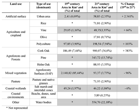
A comparable synthesis of the of land use and land cover types in the Sado region in the 19th and 21st centuries has been produced (Figure 5). In the 19th-century map, areas with unavailable information were included in the main land use category of their surroundings, as there is no cartographic coverage of these sectors. The areas of the polygons representing different land uses were calculated to estimate the changes that occurred over the period. This analysis is presented in Table 1, quantifying the areas of the activities that have decreased, in favour of the expansion of others.
The total area obtained for the 19th and 21st centuries have a slight difference of less than 5 km2 (around 0.2%), quite acceptable for the accuracy of the historical maps.
In the 19th century, the study area was almost entirely covered by natural vegetation - heaths, shrubs, and other spontaneous species, accounting for 85.44% of the area (Table 1). The exceptions were around 10% of scattered oak areas and around 5% of polyculture along the Sado riverbank. In the current century, the natural vegetation has been strongly replaced by pine forests, which are now planted to control erosion of the sandy soils and dunes in this area. Additionally, there is a noticeable expansion of cork oak “montados”, often intermingling with pine forests, increasing by around 300%, from less than 200 km2 to over 900 km² (Table 1).
In the past, polycultures extended over an area of almost 100 km2 and were more concentrated around Setúbal, which already had a consolidated urban area in the 19th century. This type of land use included orchards and mainly cereal crops such as wheat. In the current century, their area has decreased due to the growing process of urbanization, but in other municipalities, it has grown, occupying almost 200 km² (Table 1), representing an increase of over 100%.
Vineyards have been cultivated since the 19th century, covering almost 29 km², and are a cultural feature in the Palmela region. At that time, there were vineyard properties in Alcácer, but not very significant. Today, different grape varieties continue to be produced in Palmela and Setúbal, in sectors of the mountain ranges that make up the Arrábida Chain and in extensive plains, marking a territorial expansion of 65% (Table 1).
The changes in coastal wetlands over the analyzed time period are noteworthy. These areas at the continent-ocean interface, corresponding to high and low marshes, are highly dependent on tidal fluctuations, protecting important and vulnerable coastal biomes. In the past, these areas occupied a territory of 49.24 km² compared to 46.22 km² today. This 6% reduction may be related to erosive processes due to anthropogenic actions such as: i) river channel damming, which retains part of the sediments and modifies deposition processes in the estuary; ii) degradation of riparian forests, deforestation, etc., or iii) natural causes - climate change and sea level raise.
Table 1 presents some gaps due to the lack of all agricultural maps from the 19th century, but it provides a snapshot of the past and present situations. Thus, armed with this analysis, the entities responsible for regulating activities in the territory of the Sado estuary municipalities can deepen this knowledge and define more sustainable actions for the future.
5. Conclusions
The current socio-environmental crisis faced by modern urban-industrial societies is a legacy of a time when it was believed that the planet's natural resources were infinite. Until the end of the 20th century, the management, governance, and appropriation of natural resources were not planned with sustainability in mind, aiming to ensure the maintenance of future generations.
Today, there is a need to establish new relationships between society and nature, based on rationality, as natural or induced environmental problems are manifesting - climate change, rising sea levels, desertification, water and air pollution, soil erosion, etc. - and point to an unsustainable future for humanity.
The multi-temporal analysis revealed that the territory of the Sado estuary municipalities presents a mosaic of different economic activities. Some are quite traditional and inherited from the Mesolithic period, such as fishing and shellfish collection, while others where gradually introduced in response to market demands or by economic interest groups, oak and pine forestry, rice and wheat crops or more recently mining and industrial port activities. Some recent land uses have been particularly aggressive to more environmentally vulnerable areas. There has been a lack of analysis of the “carrying capacity” of the environment, or an evaluation of the potential for its resilience. Environmental impacts are clearly increasing in this region, compromising the maintenance of its natural resources for future generations.
The application of geoprocessing techniques using Geographic Information Systems (GIS) allows large areas of the territory to be observed and analysed at any scale - macro or micro. Thus, the generated cartographic products enable the development of environmental planning focused on sustainability, proposing the reorganization of land uses based on new management practices, defining the protection of areas with vulnerable ecosystems, monitoring deforestation, and degradation of natural resources, in order to achieve better environmental and social quality.
It is necessary to foster debates about the sustainable use of natural resources closer to effective actions that can make it feasible. For this, it is necessary for governments to propose and adopt socioeconomic models that avoid the degradation and waste of these resources, defining the environment as a priority over simply economic goals. The consumption patterns of modern societies need to be reconsidered, aiming to balance development and environmental, economic, social, political, and cultural sustainability. It is necessary to recognize that the physical environment is the support of life and human activities. With increased knowledge and awareness, it will be possible to project the well-being and maintenance of current and future generations.
Author Contributions
Conceptualization, N.M.S.A., N.P. and M.C.F.; Methodology, N.M.S.A.; Investigation, N.M.S.A., N.P. and M.C.F.; Resources and Data curation, M.C.F., M.I and A.G.C.; Writing—original draft preparation N.M.S.A., D.B.S. and N.P.; Writing—review and editing, N.M.S.A., N.P. and M.C.F. All authors have read and agreed to the published version of the manuscript.
Funding
This research received no external funding.
Data Availability Statement
The original contributions presented in the study are included in the article; further inquiries can be directed to the corresponding author.
Acknowledgments
The authors would like to thank to Lucas Maecone (UFS, Sergipe, Brasil) for the detailed preparation of the Maps for this work.
Conflicts of Interest
The authors declare no conflict of interest.
References
- Fasona, M.; Omojola, A. Land cover change and land degradation in parts of the southwest coast of Nigeria. African Journal of Ecology 2009, 47, 30–38. [Google Scholar] [CrossRef]
- de Jong, R.; de Bruin, S.; Schaepman, M.; Dent, D. Quantitative mapping of global land degradation using Earth observations. International Journal of Remote Sensing 2011, 32, 6823–6853. [Google Scholar] [CrossRef]
- Bajocco, S.; De Angelis, A.; Perini, L.; Ferrara, A.; Salvati, L. The impact of land use/land cover changes on land degradation dynamics: a Mediterranean case study. Environmental Management 2012, 49, 980–989. [Google Scholar] [CrossRef] [PubMed]
- Mbow, C. , Brandt, M., Ouedraogo, I., De Leeuw, J., & Marshall, M. What four decades of earth observation tell us about land degradation in the Sahel? Remote Sensing 2015, 7, 4048–4067. [Google Scholar]
- Nagendra, H. , Mairota, P., Marangi, C., Lucas, R., Dimopoulos, P., Honrado, J. P., Blonda, P. Satellite Earth observation data to identify anthropogenic pressures in selected protected areas. International Journal of Applied Earth Observation and Geoinformation 2015, 37, 124–132. [Google Scholar] [CrossRef]
- Singh, S. K. , Srivastava, P. K., Szabó, S., Petropoulos, G. P., Gupta, M., & Islam, T. Landscape transform and spatial metrics for mapping spatiotemporal land cover dynamics using Earth Observation data-sets. Geocarto International 2017, 32, 113–127. [Google Scholar]
- Xie, Z.; Phinn, S. R.; Game, E. T.; Pannell, D. J.; Hobbs, R. J.; Briggs, P. R.; McDonald-Madden, E. Using Landsat observations (1988–2017) and Google Earth Engine to detect vegetation cover changes in rangelands-A first step towards identifying degraded lands for conservation. Remote Sensing of Environment 2019, 232, 111317. [Google Scholar] [CrossRef]
- Giuliani, G.; Chatenoux, B.; Benvenuti, A.; Lacroix, P.; Santoro, M.; & Mazzetti, P. Monitoring land degradation at national level using satellite Earth Observation time-series data to support SDG15 – exploring the potential of data cube. Big Earth Data 2020, 4, 3–22. [Google Scholar] [CrossRef]
- https://sustainabledevelopment.un.org/content/documents/5987our-common-future.pdf (acessed 10th April 2024).
- https://sustainabledevelopment.un.org/outcomedocuments/agenda21 (accessed 10th April 2024).
- https://www.dgadr.gov.pt/cartografia/cartas-pery/carta-agricola-50000 (accessed 10th April 2024).
- https://smos.dgterritorio.gov.pt/cartografia-de-uso-e-ocupacao-do-solo (accessed 10th April 2024).
- http://apambiente.pt/_zdata/Politicas/Agua/PlaneamentoeGestao/PGRH/20162021/PTRH6/PGRH6_Parte2.pdf. (acessed 10th April 2024).
- Inácio, M. Evolução morfossedimentar do sapal da Caldeira de Tróia em contexto de subida do nível médio do mar. PhD Thesis 2017, ULisboa. https://repositorio.ul.pt/handle/10451/31656 (accessed 10th April 2024).
- Brito, P. Impactos da elevação do nível médio do mar em ambientes costeiros: o caso do estuário do Sado. PhD Thesis 2009, ULisboa. http://hdl.handle.net/10451/3151 (accessed 10th April 2024).
- https://www.ipma.pt/pt/oclima/series.longas/?loc=Set%C3%BAbal&type=raw (acessed 10th April 2024).
- Pimentel, N.L. O terciário da Bacia do Sado: sedimentologia e análise tectono-sedimentar. PhD Thesis 1997, ULisboa. https://www.researchgate.net/publication/356814643 (accessed 10th April 2024).
- Costa, A.M.; Freitas, M.C.; Mota, R.; Leira, M.; Andrade, C.; Pimentel, N.; Araújo, A.C.; Bao, R.; Diniz, M.; Arias, P. Sado palaeovalley configuration: implications for the Mesolithic settlement during the Holocene sea-level rise. A. Roque, C. Brito, C. Veracini (Eds.), People, Nature and Environments: Learning to Live Together. Part 4 - Landscape and Heritage, Chapter Thirteen, Cambridge Scholars Publishing 2020, 176-194.
- Clark, P.U.; Dyke, A.S.; Shakun, J.D.; Carlson, A.E.; Clark, J.; Wohlfarth, B.; Mitrovica, J.X.; Hostetler, S.W.; McCabe, M. The Last Glacial Maximum. SCIENCE 2009, 325, 5941–710-714. [Google Scholar] [CrossRef] [PubMed]
- Carvalho, A. F. O Mesolítico Final em Portugal. In Utrilla Miranda and Montes Ramirez (Eds.) El Mesolítico Geométrico en la Península Ibérica. Monografías Arqueológicas de la Universidad de Zaragoza 2009, 44, 33–68. [Google Scholar]
- Mayet, F.; Tavares da Silva, C. Roman Amphora Production in the Lower Sado Region. In Inês Vaz Pinto, Rui Roberto de Almeida and Archer Martin (Eds.) Lusitanian Amphorae: Production and Distribution. Archaeopress Publ. Ltd. 2016. 59-72. http://hdl.handle.net/10451/31694 (accessed 10th April 2024).
- Quintas, M.C. Setúbal: economia, sociedade e cultura operária: 1880-1930. Livros Horizonte, Lisboa, 1998. 568 pp, ISBN 978-972-24-1028-8.
- Belo, C. C.; Coelho, I.; Rolo, J.; Reis, P. Sistemas agroflorestais em Portugal continental. Parte II: montados, condições de uso do solo e evolução. Revista de Ciências Agrárias 2014, 37, 122–130. [Google Scholar]
- https://dspace.uevora.pt/rdpc/bitstream/10174/3547/1/9CNA%20Caveira.pdf (accessed 10th April 2024).
- https://siaia.apambiente.pt/AIADOC/PA444/rm%202012201941813153.pdf (accessed 10th April 2024).
- https://www.icnf.pt/api/file/doc/89d8861657451075 (accessed 10th April 2024).
Figure 1.
Location of the study area, corresponding to the estuarine municipalites (in yellow), of the larger Sado River drainage basin (in dark grey on the inset).
Figure 1.
Location of the study area, corresponding to the estuarine municipalites (in yellow), of the larger Sado River drainage basin (in dark grey on the inset).
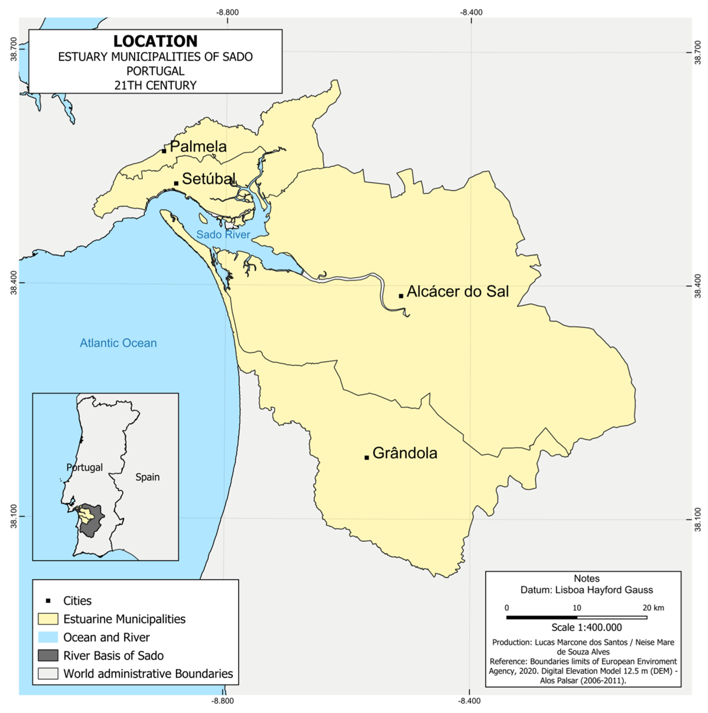
Figure 2.
Mosaic of eleven Pery maps representing the Land use and coverage of the study area in the 19th Century.
Figure 2.
Mosaic of eleven Pery maps representing the Land use and coverage of the study area in the 19th Century.
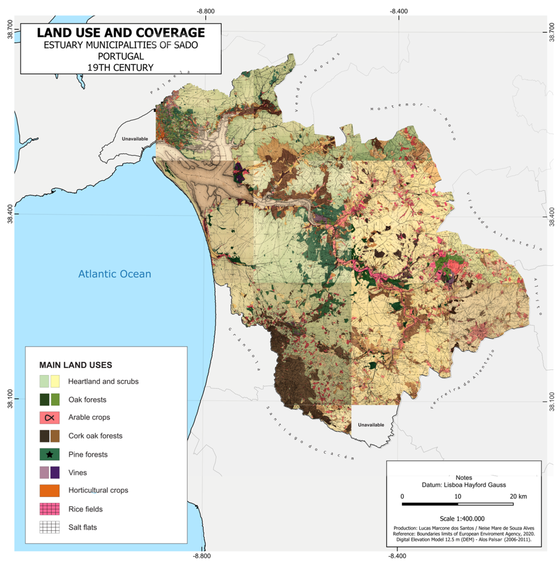
Figure 3.
Land use and coverage of the study area, based on a mosaic of the 21st century COS 2018 maps.
Figure 3.
Land use and coverage of the study area, based on a mosaic of the 21st century COS 2018 maps.
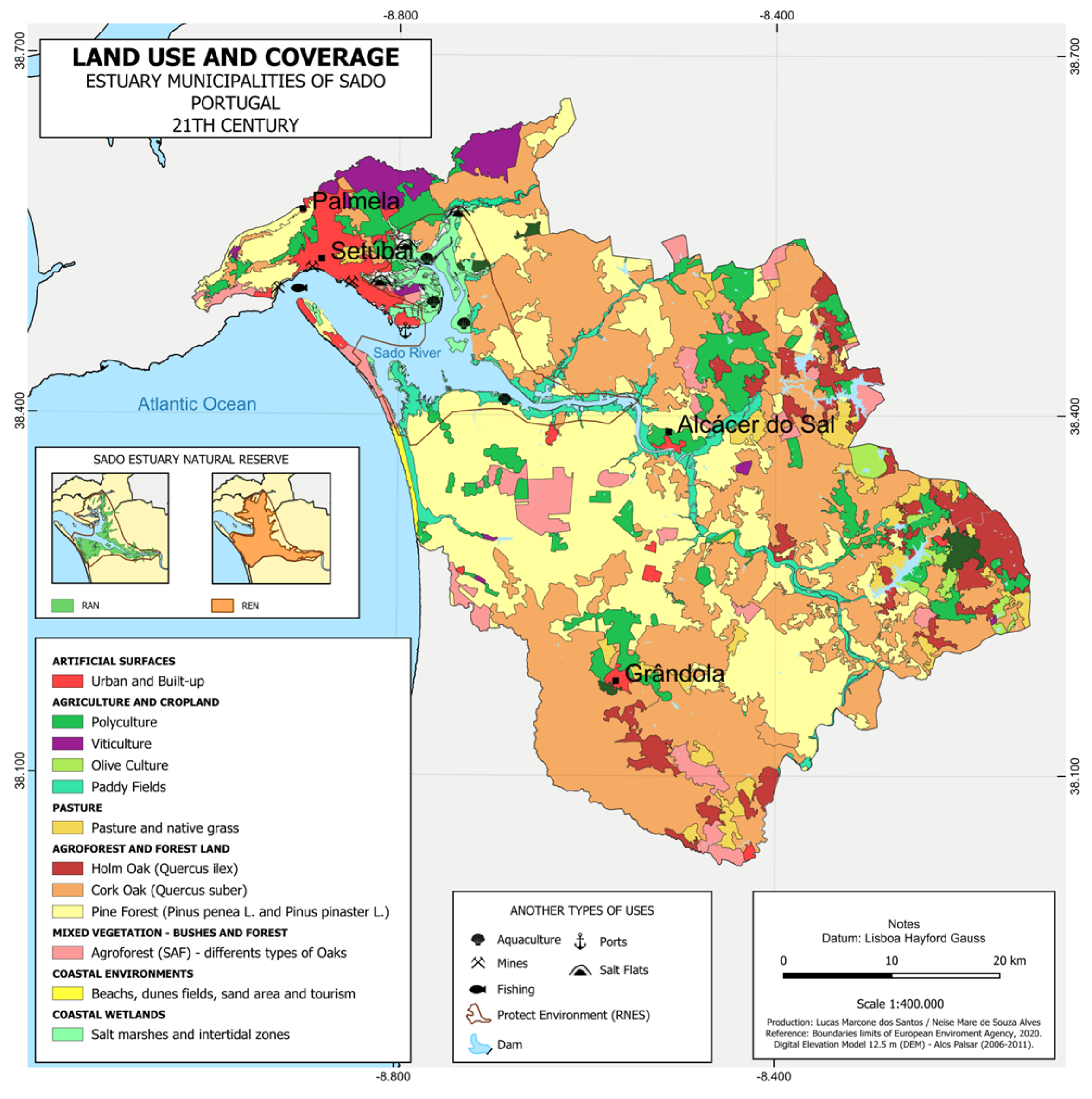
Figure 4.
Anthropogenic interventions in the landscape. (a) Salt production on a tidal plain, close to Gâmbia ; (b) paddy field with rice cultivation on the Sado river’s floodplain and smooth hills with pine forests, South of Alcácer do Sal; (c) traditional “montado” with cork oak trees; (d) piling up of extracted cork; (e) sand extraction on eolian Holocene dunes, at Lagoa Salgada; (f) “montado with cork oak or holm oak trees and cattle; (g) urban growth of Setúbal city (view from the Palmela castle, from North to South).
Figure 4.
Anthropogenic interventions in the landscape. (a) Salt production on a tidal plain, close to Gâmbia ; (b) paddy field with rice cultivation on the Sado river’s floodplain and smooth hills with pine forests, South of Alcácer do Sal; (c) traditional “montado” with cork oak trees; (d) piling up of extracted cork; (e) sand extraction on eolian Holocene dunes, at Lagoa Salgada; (f) “montado with cork oak or holm oak trees and cattle; (g) urban growth of Setúbal city (view from the Palmela castle, from North to South).
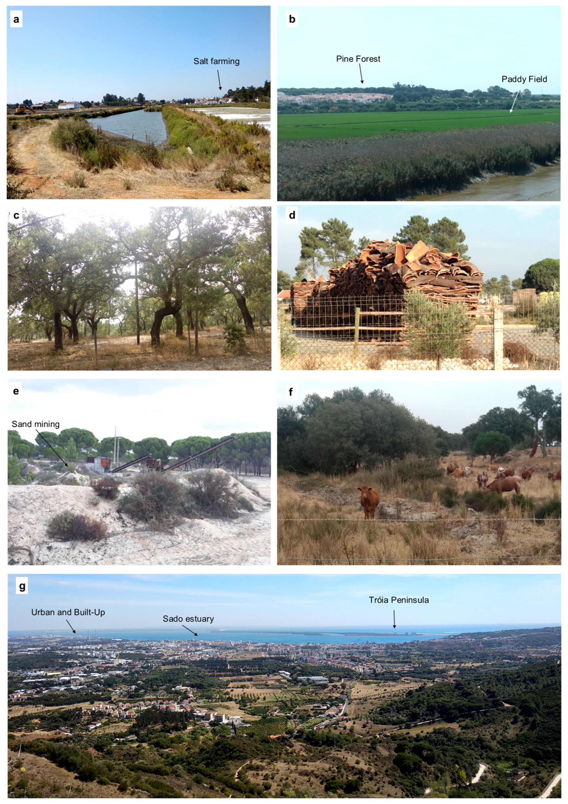
Figure 5.
Comparative maps of Land Use and coverage, based on the 19th century Pery maps (left hand side) and the 21st century COS 2018 maps (right hand side).
Figure 5.
Comparative maps of Land Use and coverage, based on the 19th century Pery maps (left hand side) and the 21st century COS 2018 maps (right hand side).
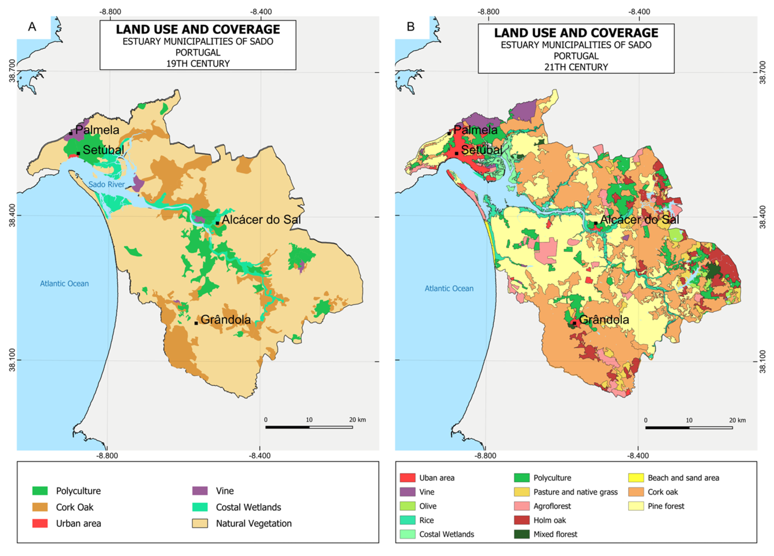

Table 1.
Quantitative comparison between the 19th century and 21st century Land use and occupation (see also Figure 5).
Table 1.
Quantitative comparison between the 19th century and 21st century Land use and occupation (see also Figure 5).
Disclaimer/Publisher’s Note: The statements, opinions and data contained in all publications are solely those of the individual author(s) and contributor(s) and not of MDPI and/or the editor(s). MDPI and/or the editor(s) disclaim responsibility for any injury to people or property resulting from any ideas, methods, instructions or products referred to in the content. |
© 2024 by the authors. Licensee MDPI, Basel, Switzerland. This article is an open access article distributed under the terms and conditions of the Creative Commons Attribution (CC BY) license (https://creativecommons.org/licenses/by/4.0/).
Copyright: This open access article is published under a Creative Commons CC BY 4.0 license, which permit the free download, distribution, and reuse, provided that the author and preprint are cited in any reuse.