Submitted:
15 March 2024
Posted:
18 March 2024
You are already at the latest version
Abstract
Technological advancements in the Internet of Things (IoT), unmanned aerial vehicles (UAVs), and novel technological tools have transformed disaster management practices from localized approaches to a global framework. These innovations necessitate a unified understanding and application of diverse methodologies at an international level, ensuring they are accessible and operational across different sectors. This integration is crucial not only for technical personnel but also for medical teams, who play a pivotal role in disaster response and management. By fostering a comprehensive grasp of these methods, we can enhance coordination, efficiency, and effectiveness in addressing disasters on a global scale. The authors aimed to provide a comprehensive overview of emerging techniques that are driving shifts in strategic approaches and treatment technologies. Recognized as a domain of continuous research and development, this overview, by necessity, remains an incomplete snapshot of an evolving field. It highlights the dynamic nature of technological and strategic advancements, underscoring the importance of ongoing investigation and innovation to stay abreast of current trends and future directions. The article also highlights the importance of international collaboration beyond societal and national boundaries A single paragraph of about 200 words maximum. For research articles, abstracts should give a pertinent overview of the work. We strongly encourage authors to use the following style of structured abstracts, but without headings: (1) Background: Place the question addressed in a broad context and highlight the purpose of the study; (2) Methods: briefly describe the main methods or treatments applied; (3) Results: summarize the article’s main findings; (4) Conclusions: indicate the main conclusions or interpretations. The abstract should be an objective representation of the article and it must not contain results that are not presented and substantiated in the main text and should not exaggerate the main conclusions.
Keywords:
Mass casualties
; Search and Rescue
; Internet of Things
; Artificial Intelligence
; drones
; remote Sensors
; telemedicine
1. Introduction
Optimizing healthcare disaster response in the modern era involves a blend of real-time data collection, standardized data elements, analysis and predictive analytics, strategic resource planning, telemedicine, and the integration of traditional and modern response strategies, all underpinned by continuous training and improvement. Much progress has been made in gathering and analyzing information in real-time to support mass-casualty management. This includes data on the number and severity of casualties; the nature of injuries; available resources like medical supplies, personnel, and facilities; and environmental conditions. Advanced technologies like artificial intelligence (AI), the Internet of things (IoT), mobile diagnostic apps, and cloud platforms can streamline disaster-response efforts. This paper focuses on recent research findings in this area, building upon established technologies. Optimizing healthcare disaster response by technological means, by delivering care faster and with greater accuracy, will save live. Table 1 summarizes the key points of technological support of disaster response, with a focus on AI.
2. Results
To make data from various sources useful, it is essential to use pre-defined, standardized data elements across all platforms and stakeholders. This ensures efficient integration, analysis, and modeling of data, covering aspects like injury types, condition of the casualties, resource levels, and environmental conditions. In modern disaster management, the integration of diverse information sources is crucial. This includes data on the status and location of each patient, gathered from various channels, amongst others. Table 2 summarizes the modern technologies discussed, along with brief description of each.
This information should be consolidated in a unified dataset, serving as a foundational pillar. It should encompass the electronic medical record for medical details and be complemented by a non-medical record for a holistic view of each patient's situation.
3. Contemporary Technical Means for Data Acquisition
The Internet of Things (IoT) represents a comprehensive network wherein physical objects, often referred to as "things," are integrated with sensors, software, and other technological tools. This integration enables a connection among these objects, and exchange of data efficiently. The core concept of IoT lies in the embedding of digital and computing capabilities into everyday objects, thereby transforming them into smart, interconnected devices[1].
Modern sensing tools need carriers of the “sensing organs” and networks to communicate and deliver the results. Standard infrastructure may lack internet access in critical areas, particularly when damaged or overloaded by natural or human factors. The management of mass casualties then will require a dedicated information technology system.
3.1. Carriers of Sensors for AI: UAVs, Robots, Telediagnosis Tools, Smart Glasses, and Hazard Detectors
The expansion of UAVs, drones, and robots in the last decade is attributed to advancements in technology risk reduction at lower costs. Unmanned vehicles can be aerial (UAV), ground vehicles (UGV), and underwater vehicles [2] which can be remotely or autonomously controlled.
Their application in health-related fields is emerging and gaining acceptance. In emergency medicine, drone technology shows significant promise for improving patient outcomes through rapid response without endangering rescue personnel. Current studies focus on using drones for establishing information networks, delivering defibrillators for out-of-hospital cardiac arrests, transporting blood and blood products for trauma cases, providing rescue medications, and developing triage and patient transport systems [3,4]. Additionally, drones can be instrumental in establishing networks for IoT applications[3].
UAVs beside military uses serve with two main functions--first, as a transportation tool for work robots, medication delivery, and for patients; second, as medical robots with special sensors as part of the IoT. Furthermore, drones can be utilized to deliver lifesaving first aid supplies, such as dressings, pain relievers, or even defibrillators, directly to the scene. This becomes particularly crucial when on-site access for rescue teams is challenging, or the magnitude of the damage necessitates swift on-site assistance.[5]
UAV size ranges from ultra-small (maximum wingspan of less than 7.5 cm), small (15-200 cm), medium (2-10 m), and large (greater than 10 m). They can be fixed-wing systems, be driven by vertical takeoff and landing (VTOL) quadrotor systems, or a combination of both. UAVs are especially useful in areas too dangerous or inaccessible for medical personnel, or in optimizing access in heavy traffic[6]. They can be equipped with optical cameras, thermal imaging, multispectral cameras, LIDAR (LIght detecting and ranging) cameras, radar, high-resolution cameras, and other imaging systems.
Drones offer the advantages of quick deployment compared to ground vehicles; high speed; scalability; and low costs--significantly enhancing emergency-response capabilities. Besides a transport system for robots[7], they can provide communication services with patients by bidirectional video and audio systems, evaluating the mental status of victims by a score like the Glasgow Coma Score in addition to pulse oximetry [2]. The robotic platform “Spot,” developed by Boston Dynamics,[8] enables the measurement of vital signs without direct physical contact from a distance of up to 2 m [9,10].
3.2. Autonomous Tools
Unlike remotely controlled vehicles, autonomous drones and robots navigate independently using technologies like cameras, LIDAR, GPS, or radar. AI and machine learning interpret these data, enabling drones and robots to identify obstacles, alter their path, and perform tasks without human help. These algorithms are essential for adapting to changing conditions[11] like land-slides or avalanche or flooding[12].
While used in the military, they are also employed commercially and in civilian sectors, such as researching in hard-to-reach or dangerous areas. Such systems can overcome the limitations of long distances by sending the other UAVs to calculate relay positions and transmitting the results to the home base[13].
UAVs are important in an initially confusing mass-casualty situation and can help to clear the situation. The first step is to ensure safety for all people in the area where the event took place. This can be supported by unmanned vehicles on the ground.

Table 3.
Aspects of hazard evaluation by unmanned vehicles.
| Aspect | Description | Importance |
|---|---|---|
| Identification and Risk Analysis | Conducting a thorough assessment of potential hazards, including their nature and extent. | Critical for understanding the scope and severity of the incident. |
| Evaluation of Risks | Evaluating risks to patients, the environment, and first responders. | Essential for ensuring the safety of all involved and effective response planning. |
| Information Availability | Ensuring information is readily available to incident command, first responders, and later clinicians. | Vital for coordinated and informed decision-making during the incident. |
| Victim Classification | Classifying victims for system-wide assessments and mathematical modeling. | Allows for efficient transport decisions and optimal use of resources. |
| Crisis Standards of Care | Enabling the fair application of Crisis Standards of Care. | Ensures equitable treatment and resource allocation during high-pressure situations. |
| Safety of Care Teams | Providing information on the safety of care teams and ongoing risks. | Crucial for maintaining the well-being of responders and effective management of the situation. |
| Casualty and Resource Assessment | Assessing ongoing risks of casualties, incoming wounded, and the availability of personnel and supplies. | Key for continuous response adaptation and resource management. |
| Infrastructure Availability | Understanding the availability of personnel and supplies infrastructure. | Important for planning and executing SAR operations effectively. |
| Review for Improvement | Making information available for future process improvement reviews. | Enables learning and enhancement of response strategies for future incidents. |
3.2.1. Contact and Non-Contact Sensors
To avoid physical presence in an endangering surrounding, use of non-contact sensors is increasing. Due to ongoing research and development in this field, only an extract can be presented.
Table 4.
Remote non-contact sensors: Types and indications.
| Remote non- contact Sensor Type | Indication | Usefulness in SAR operations |
|---|---|---|
| Optical Cameras | Provide high-resolution imagery for day-time operations. | Helpful in identifying individuals, structures, and terrain features. |
| Infrared Sensors | Heat signatures | Especially useful in night-time or low-visibility conditions in locating people or animals. |
| Infrared Thermography | Can detect and measure surface temperature of the body | Infrared cameras create thermal images. The maximum distance is dependent on camera resolution, sensitivity, environmental components |
| Multispectral and Hyperspectral Sensors | Capture data across different wavelengths. | Useful for vegetation analysis, body water detection, and environmental assessment |
| GPS Trackers | Used for tracking the location of SAR teams, equipment, or individuals in distress. | locating submerged objects, and navigation. Essential for coordination and navigation |
| Satellite Imagery | Provides broad-area coverage. | Useful for initial assessment, planning, and monitoring large-scale operations |
| Radar Systems | Penetrating fog and cloud cover. | Effective in various weather conditions for mapping terrain and detecting movements. |
| Ground Penetrating Radar | Detecting victims in collapsed buildings and avalanches[14]. | 3D reconstruction with augmented reality. Can detect living objects behind walls from a distance of over 100 m[15] even over distances of 4 m[16]. |
| LIDAR | Detailed 3D mapping of terrain; understanding topography and identifying hazards or access routes. | Distances up to 700 m; error rate of 3.3% for missing and 0.06 for false positives in human shape identification. Useful for understanding topography and identifying potential hazards or access routes. The effect may be reduced by fog [17]. |
| UAVs/Drones | Transport media for sensors in flexible, rapid aerial surveillance; real-time imagery, accessing hard-to-reach areas, delivering supplies. | Equipped with high-resolution cameras, Lidar, and/or radar for 3D mapping and risk evaluation. |
| Thermal Cameras | Non-contact assessment of respiratory rate, heart rate, body temperature | Long-range thermal zoom cameras can identify persons or vehicles up to more than 2 km away ; useful in various SAR scenarios.[18] |
| Non-contact Measurement of Vital Signs | Telemetry systems for heart rate, respiratory rate, and temperature without direct physical contact. | Robots using sensors developed for contactless measurements; accuracy depends on distance to the object[19] |
| Auditory perception microphones | Audio acquisition, feature extraction and Feature mapping | Detection of distress signals (cry for help), addition to visual or thermal sensing in zones of poor visibility, expanding the range of detection beyond the reach of thermal or visual discrimination[20] |
3.2.2. Simple Cameras
Pictures from a disaster scene may help operators to identify victims walking from those not moving. This may help to assess the magnitude and severity of the event. Drones used in search and rescue operations in avalanches were equipped with a camera that captured images of the search area. The images were then transmitted in real-time to a monitor, allowing the search team to view the footage and locate the victim, who was reached by snowmobile[21]. Another study showed that drone SAR was faster than conventional means[22]. Detection of breathing activity can be done even by standard smartphone cameras by adaptive breathing motion detection, adaptive region of interest detection, or motion detection by real-time videos[10,23].
3.2.3. Multispectral and Thermal Imaging
These systems can help locate victims in collapsed buildings, in the mountains after avalanches, or in other dangerous conditions. Information on hazards, like toxicity, radioactivity[24], or ongoing fires can be retrieved. They can also identify structural instability, early storm warnings, earthquake aftershocks [25], or tsunamis[26].
Another innovative approach is contactless video photoplethysmography, detecting the subtle changes of the skin color by the pulse wave. Color changes correlate to the volume changes occurring with the pulsative flow. Algorithms can analyze skin color variations and extract heart rate, respiratory rate and even oxygen saturation.
Thermal cameras can assess parameters like respiratory rate (RR), heart rate (HR), and body temperature[27]. Temperature changes around the nostrils during breathing, documented by thermal images of the face and identification of the ROI around the nostrils by deep learning, can identify the respiratory rate. By training, the accuracy of identifying the respiratory rate is 97% [28]. Fahri et al. [29] used a system which detects temperature of the face with a FLIR camera, to identify people with temperatures above a certain limit with an accuracy of 98.1% . Long-range thermal cameras can penetrate fog and haze, and identify even camouflaged persons or vehicles at distances of 15 km or even more depending on the camera configuration[30].
Infrared cameras usually operate in the long-wavelength infrared spectrum (8-14 μm). The distance at which the temperature can be measured accurately with an infrared camera depends on the camera’s resolution and field of view. Remote body plethysmography combined with infrared thermography can overcome limitations of traditional body plethysmography[31], but showed the same biases as contact plethysmography with a mean error of 2%[32] when captured from a mobile phone. Infrared cameras are commonly used for fever detection in travelers. To improve the precision of non-contact systems affected by ambient temperature and subject distance, implementing a verified algorithm[33] can enhance accuracy by adjusting for these variables.
FLIR cameras can operate in various parts of the infrared spectrum, in mid-range (3 - 5 μm) and long-range (8-14 μm) wavelengths. Together with high-resolution cameras they have been used in many SAR missions [34], in pandemics to detect the spread of coronavirus[35], and after earthquakes to detect damage in critical infrastructure [36]. FLIR cameras can measure temperatures even over long distances.
3.2.4. LIDAR
LIDAR (Light imaging, detection and ranging) is an active remote sensing system[37] based on the principles of radar but using pulsed laser light instead of radio waves for measuring distances to surfaces. Distances up to 700 m and more are described[38]. After a disaster, roads may be damaged, rocks and debris or avalanches might change the landscape, so that areas cannot be accessed easily. Search and rescue procedures must be planned to avoid danger. UAV equipped with high resolution cameras, LIDAR and /or radar can create three-dimensional maps of the landscape and enable risk evaluation. LIDAR scans together with AI can identify human shapes with an error rate of 3.3 % (missing) and 0.06 at a false positive rate[39].
3.2.5. Ground-Penetrating Radar
Ground-penetrating radar is a valuable instrument to detect victims in collapsed buildings and in avalanches. In combination with interactive augmented reality, it can give information on voids, depth of burying and three-dimensional reconstruction[14].
3.3. Non-Contact Vital Signs
In the field of traditional medical telemetry, systems rely on contact sensors attached to patients to monitor vital signs such as heart rate, blood pressure, respiratory rate, and oxygen saturation.
However, non-contact telemetry systems, which are currently in development, utilize different physiological components to gather health data. Pulse can be measured by photo-plethysmography, Doppler radar, and infrared thermography. These systems are more susceptible to measurement inaccuracies compared to their contact-based counterparts.
Robots like “Spot” or “Snake robot[11]” were developed to enable contactless measurements[19,40] in critical conditions . Huang describes the dependency on the distance to the object[41]. For telemetric determination of vital parameters thermal cameras, radar sensors, and acoustic sensors are in use[27]. Telemetric measurement of body temperature can be important, especially in pandemic situations.
The accuracy of SpO2 (oxygen saturation) measurements can be affected by factors such as movement and the overall conditions during measurement. Technologies like LIDAR, capable of measuring distances over several kilometers, differ from SpO2 measurement methods which require close proximity to the skin. Casalino et al. [42] demonstrated that recording videos with an RGB camera at a distance of approximately 50 cm, and up to 1.1 m, showed no significant differences in SpO2 readings even when the subject's head, where the measurement area was focused, was moved. This suggests that SpO2 measurements can remain reliable within this range of distance despite minor movements; distances out of this range must be seen as unreliable.
Contactless video photoplethysmography enables the measurement of vital signs without direct physical contact. It works on registering the slight changes in skin color with each heartbeat. Technical details are described in Pirzada et al[43]. After preprocessing and noise reduction techniques, the system provides measurements with low rates of statistical errors, although the most suitable methods of preprocessing and validation are not clear up to now.
3.4. Virtual Burn Assessment Teams (vBAT) and Virtual Burn Support Teams (vBST)
In large-scale emergencies, especially when dealing with the influx of burn victims, efficient and prompt emergency care is crucial to save lives and ensure optimal medical treatment for patients. The integration of drones and telemedicine solutions can offer an innovative and effective approach. Drones can be deployed in the initial phase to provide a rapid situational assessment. From the air, they can survey the affected areas, providing real-time information on the extent of damage, the location of casualties, and potential hazards. These data are transmitted in real-time to emergency services and medical teams, facilitating precise deployment planning (1).
These technologies are also potentially suitable for forming virtual Burn Assessment Teams (BAT) and Burn Support Teams (BST) (Figure 1 and Figure 2).
These virtual teams enable a rapid assessment of the extent of injury in severe burn victims remotely; they can provide recommendations for further treatment and assist on-site emergency personnel in patient triage. These systems not only assess the severity of injuries but also offer acute therapy recommendations and guidance for immediate interventions. This can be crucial in providing timely medical support to the injured and coordinating transportation to specialized facilities, if necessary. Various systems for these purposes are currently under testing or in use.
Modern data glasses and instant remote interactive support provides two-way communication between a wearer and a remote viewer. Images and annotated pictures can be sent back to the heads-up display in the glasses for the wearer to view. This may improve triage, enable better resource allocation, and enhance preparedness by collaboration of the first responders and the physicians in an emergency department. The technologies can be used to support Burn Assessment Teams (BAT) and Burn Support Teams (BST). By using these remote assistance services, doctors can help save lives without the need for travel while also reducing the time to deliver care.
3.5. Influence of AI on Training for Disaster Response
Virtual reality is used for training and simulation of mass-casualty response[44], as well as in training for emergency response in motor sports. In burns, the situation is different. Numerous national and international training programs, like Advanced Burn Life Support (ABLS) and Emergency Management of Severe Burns (EMSB), focus on priority-oriented diagnostic and treatment approaches. These programs often adhere to the ABCDE principle (Airway, Breathing, Circulation, Disability, and Exposure/Environment). The ABCDE course structure, intended for healthcare professionals, serves as a systematic approach for assessing and providing immediate care in preclinical and initial shock room situations. These courses primarily focus on direct diagnostic and immediate treatment in face-to-face situations between providers and patients. Disaster response technologies, such as those described in this paper, are not typically included in these courses. This should be addressed through interprofessional training involving technical rescue services and healthcare professionals [45].
4. Extent and Depth of Burns
Remote assistance services enable local medical teams to significantly enhance their capabilities by accessing global expertise. However, as of now, there is no clinically validated tool for accurately determining the depth of burns solely from photographs. Additionally, due to the inherent limitations of photographs in capturing only one perspective, it is challenging to ascertain the full extent of burns.
5. Impact of New Technical Means
This information, as well as the in-time analysis should be readily available to the incident command and later to the clinician. It should be able to classify victims for system-wide assessments and mathematical modelling allowing transport decisions, appropriate use of scarce resources, and fair application of Crisis Standards of Care. Furthermore, information on safety of the care teams, on-going risks of casualties and incoming wounded and the availability of infrastructure, personnel and supplies is critical to run a successful. Finally, the information should be available to review for process improvement in the future.
Not only can drones augment the command/supervisory role, but they can also influence direct field operations. For example, Jain et al [46] performed a simulation trial of using drones to augment field triage and casualty evacuation and found statistically faster triaging of patients, without a sacrifice in accuracy, in both day and night conditions. These and other modern technologies can be used to support Burn Assessment Teams (BAT).
5.1. Aerial Triage
Álvarez-Garcia et al developed an aerial remote triage system[3]. Major bleeding, classified as priority 1, is determined by visual classification by the drone operator [3] from visible signs of it. Drones with loudspeakers can also address crowds, such as directing them to safety or to perform behaviors directed by emergency personnel staff. One such application may be for direction of mass decontamination in chemical, biological, radiological, and nuclear (CBRN) disasters. In this manner, drones would be a valuable field resource and more cost-efficient than manned aerial emergency response apparatus (e.g., helicopters).
Accompanied by infrared sensors, photos, and loudspeakers, drones can give first results on the victims and their condition when spoken to, whether they could walk (request: remain standing), if not to move body parts and the optical identification of major bleeding which may be helpful in determining priorities in triage.
5.2. Wearable Devices and Contact-Based Sensors
The combination of wearable devices and contact-based sensors opens a broad field of applications, especially in unaccompanied patient transport[47] after primary medical treatment. Continued technical advances are needed to increase payload capacities, increase flying distances, and integrate drone networks into existing 9-1-1 and EMS systems. Drones are a promising technology for improving patient survival, outcomes, and quality of life, particularly for those in areas that are remote or that lack funds or infrastructure. [48]
Table 5.
The international electronic medical record.
| Area | Description |
|---|---|
| Data Validation | Using AI to ensure accuracy and consistency, detecting anomalies, errors, or inconsistencies in the data. |
| Legal and Healthcare Compliance | Adhering to regulations such as HIPAA and GDPR to ensure lawful and ethical data handling. |
| Data Privacy and Security | Implementing security measures like encryption and access controls to protect patient data. |
| Resilience Against Disruptions | Establishing backup systems and disaster recovery plans to maintain data integrity. |
| Review and Process Improvement | Continuously updating data management processes to meet evolving needs and technologies. |
| Accessibility for Review/Auditing | Ensuring easy access to data for review and auditing purposes. |
| Data Quality and Integration | Creating standardized datasets for consistency, integrating additional data for analysis, and ensuring compatibility with various sources. |
| Effortless Data Capture | Automating data feeding to reduce manual entry, crucial in disaster scenarios. |
| Real-Time Updates | Providing immediate information updates, crucial for dynamic disaster response. |
| Accessible to All Stakeholders | Making the system available to all involved in disaster management for coordinated response. |
| EMRI Focus | Optimizing real-time information for clinical decisions, combining data for forecasting and resource planning. Incorporating voice-activated commands. |
Patient tracking technologies specific to the U.S. include the Joint Patient Assessment and Tracking System (JPATS) and the TRANSCOM Regulating and Command & Control Evacuation System (TRAC2ES). Within the European Union, emergencies with trans-border effects are regulated by the Health Emergency, Preparedness and Response Authority (HERA). The European Burns Association as well as the International Society for Burn Injuries established guidelines for the management of burn mass casualties[49], but did not set up a basic data set which might serve as a foundation of an international comparison. Worldwide, there is no single, universal patient tracking system.
Without the medical records that extend from the field and systems for patient tracking, there is no way to assess the long-term consequences of actions taken during the acute disaster setting for the purposes of quality improvement or testing new interventions. The hand-off process between caregivers during transport is notably prone to human error. Up to now, no structured and generally accepted international database for mass casualties exists although there are of ongoing intentions of the EU [50].
6. Summary
Advances in technology are expected to result in systems that merge all these functions into a single app, one that would be designed to be resistant to malicious activities and be accessible when normal infrastructure is down. The progress in use of newer technologies including advanced mathematical modelling, artificial intelligence, machine learning, social media data harvesting and the Internet of Things will be a step forward and improve accuracy, efficiency, and timeliness of situational awareness data in burns treatment.
To leverage rapid advancements, integrating all aspects into a cohesive and standardized database for analysis is essential. Creating this database requires collaboration across diverse medical systems, which employ various units and outcome measures, alongside considerable innovation to address forthcoming challenges. It is imperative to establish an agreement for the objective evaluation of outcomes, free from the bias of national pride. Moreover, there must be a provision for documenting mistakes and failures without the threat of legal penalties. From the practical approach, the feasibility of the collection of a specific kind of data in a mass casualty must be evaluated, as there is a reduced sense of piling incomplete data, even when AI might find a way to use it.
Author Contributions
Conceptualization writing—original draft preparation, HH, FS, CR, SKA, CR and LPK; writing—review and editing, X.X.; project administration, HH; funding acquisition, Y.Y. All authors have read and agreed to the published version of the manuscript.
Funding
This research received no external funding.
Institutional Review Board Statement
not applicable.
Informed Consent Statement
not applicable.
References
- Ghoni, R.; Ibrahim, T. Integration of Emergency Response Management System with Internet of Things. J Phys Conf Ser 2021, 1874. [Google Scholar] [CrossRef]
- Teng, R.; Ding, Y.; See, K.C. Use of Robots in Critical Care: Systematic Review. J Med Internet Res 2022, 24, e33380. [Google Scholar] [CrossRef] [PubMed]
- Álvarez-García, C.; Cámara-Anguita, S.; López-Hens, J.M.; Granero-Moya, N.; López-Franco, M.D.; María-Comino-Sanz, I. , et al. Development of the Aerial Remote Triage System using drones in mass casualty scenarios: A survey of international experts. PLoS One 2021, 16, e0242947. [Google Scholar] [CrossRef] [PubMed]
- Schmidbauer W, Jänig C, Vits E, Gruebl T, Sauer S, Weller N, et al. Ein neues Rettungskonzept für Schwerstverletzte in militärischen und zivilen Großschadenslagen: DRONEVAC. Notfall + Rettungsmedizin 2023:1–8. [CrossRef]
- Surman K, Lockey D. Unmanned aerial vehicles and pre-hospital emergency medicine. Scand J Trauma Resusc Emerg Med 2024, 32, 1–8. [Google Scholar] [CrossRef]
- Ravish R, Swamy SR. Intelligent Traffic Management: A Review of Challenges, Solutions, and Future Perspectives. Transp Telecommun 2021;22:163–82. [CrossRef]
- Yakushiji K, Fujita H, Murata M, Hiroi N, Hamabe Y, Yakushiji F. Short-range transportation using unmanned aerial vehicles (Uavs) during disasters in Japan. Drones 2020;4:1–8. [CrossRef]
- Huang HW, Chen J, Chai PR, Ehmke C, Rupp P, Dadabhoy FZ, et al. Mobile Robotic Platform for Contactless Vital Sign Monitoring. Cyborg Bionic Syst 2022;2022. [CrossRef]
- He S, Han Z, Iglesias C, Mehta V, Bolic M. A Real-Time Respiration Monitoring and Classification System Using a Depth Camera and Radars. Front Physiol 2022;13:1–14. [CrossRef]
- Lee YC, Syakura A, Khalil MA, Wu CH, Ding YF, Wang CW. A real-time camera-based adaptive breathing monitoring system. Med Biol Eng Comput 2021;59:1285–98. [CrossRef]
- Chitikena H, Sanfilippo F, Ma S. Robotics in Search and Rescue (SAR) Operations: An Ethical and Design Perspective Framework for Response Phase. Appl Sci 2023;13. [CrossRef]
- Daud M, Mohd Daud SMS, Mohd Yusof MYP, Heo CC, Khoo LS, Chainchel Singh MK, et al. Applications of drone in disaster management: A scoping review. Sci Justice 2022;62:30–42. [CrossRef]
- Scherer J, Yahyanejad S, Hayat S, Yanmaz E, Vukadinovic V, Andre T, et al. An autonomous multi-UAV system for search and rescue. DroNet 2015 - Proc 2015 Work Micro Aer Veh Networks, Syst Appl Civ Use 2015:33–8. [CrossRef]
- Hu D, Chen L, Du J, Cai J, Li S. Seeing through Disaster Rubble in 3D with Ground-Penetrating Radar and Interactive Augmented Reality for Urban Search and Rescue. J Comput Civ Eng 2022;36. [CrossRef]
- Camero-Tech Ltd. Camero-Tech launches its groundbreaking Xaver TN Long Range system n.d. https://camero-tech.com/xaver-products/xaver-lr-80/.
- Kelly TB, Angel MN, O’Connor DE, Huff CC, Morris LE, Wach GD. A novel approach to 3D modelling ground-penetrating radar (GPR) data – A case study of a cemetery and applications for criminal investigation. Forensic Sci Int 2021;325:110882. [CrossRef]
- Cao X, Church PM, Matheson J, Roy G. Optimization of obscurant penetration with next generation lidar technology. In: Turner MD, Kamerman GW, editors. Laser Radar Technol. Appl. XXIV, SPIE; 2019, p. 26. [CrossRef]
- No Border Security Long Range Thermal Camera With 2 - 10 Km Surveillance n.d. https://www.longrangethermalcam.com/sale-10955441-border-security-long-range-thermal-camera-with-2-10-km-surveillance.html.
- Huang H-W, Chen J, Chai PR, Ehmke C, Rupp P, Dadabhoy FZ, et al. Mobile Robotic Platform for Contactless Vital Sign Monitoring. Cyborg Bionic Syst 2022;2022. [CrossRef]
- Martinez-Carranza J, Rascon C. A review on auditory perception for unmanned aerial vehicles. Sensors (Switzerland) 2020;20:1–24. [CrossRef]
- Karaca Y, Cicek M, Tatli O, Sahin A, Pasli S, Beser MF, et al. The potential use of unmanned aircraft systems (drones) in mountain search and rescue operations. Am J Emerg Med 2018;36:583–8. [CrossRef]
- McRae JN, Gay CJ, Nielsen BM, Hunt AP. Using an Unmanned Aircraft System (Drone) to Conduct a Complex High Altitude Search and Rescue Operation: A Case Study. Wilderness Environ Med 2019;30:287–90. [CrossRef]
- Romano C, Schena E, Silvestri S, Massaroni C. Non-contact respiratory monitoring using an RGB camera for real-world applications. Sensors 2021;21. [CrossRef]
- Hussain M, Mehboob K, Ilyas SZ, Shaheen S, Abdulsalam A. Drones application scenarios in a nuclear or radiological emergency. Kerntechnik 2022;87:260–70. [CrossRef]
- Zhang M, Qiao X, Seyler BC, Di B, Wang Y, Tang Y. Brief communication: Effective earthquake early warning systems: appropriate messaging and public awareness roles. Nat Hazards Earth Syst Sci 2021;21:3243–50. [CrossRef]
- Lee JW, Park SC, Kee Lee D, Ho Lee J. Tsunami arrival time detection system applicable to discontinuous time series data with outliers. Nat Hazards Earth Syst Sci 2016;16:2603–22. [CrossRef]
- Manullang MCT, Lin YH, Lai SJ, Chou NK. Implementation of thermal camera for non-contact physiological measurement: A systematic review. Sensors 2021;21:1–21. [CrossRef]
- Shu S, Liang H, Zhang Y, Zhang Y, Yang Z. Non-contact measurement of human respiration using an infrared thermal camera and the deep learning method. Meas Sci Technol 2022;33:075202. [CrossRef]
- Aufar F, Murti MA, Barri MH. Design of Non-Contact Thermometer Using Thermal Camera For Detecting People With Fever. 2021 Int. Conf. Comput. Sci. Eng., IEEE; 2021, p. 1–5. [CrossRef]
- InfraTec. Thermal Zoom Cameras | InfraTec thermography knowledge n.d. https://www.infratec-infrared.com/thermography/service-support/glossary/thermal-zoom-cameras/ (accessed December 1, 2023).
- Sun Y, Thakor N. Photoplethysmography Revisited: From Contact to Noncontact, From Point to Imaging. IEEE Trans Biomed Eng 2016;63:463–77. [CrossRef]
- Dasari A, Prakash SKA, Jeni LA, Tucker CS. Evaluation of biases in remote photoplethysmography methods. Npj Digit Med 2021;4:1–13. [CrossRef]
- Goh NWJ, Poh JJ, Yeo JY, Aw BJJ, Lai SC, Cheng JJW, et al. Design and development of a low cost, non-contact infrared thermometer with range compensation. Sensors 2021;21:1–12. [CrossRef]
- Bhaskar D, Sathish K. Infrared Thermography Based Disaster Management Using Drone and Flir Camera. Int J Pure Appl Math 2018;119:2253–62.
- Pandey S, Barik RK, Gupta S, Arthi R. Pandemic Drone with Thermal Imaging and Crowd Monitoring System (DRISHYA). Stud. Comput. Intell., vol. 936, Springer Science and Business Media Deutschland GmbH; 2021, p. 307–25. [CrossRef]
- Zhang R, Li H, Duan K, You S, Liu K, Wang F, et al. Automatic detection of earthquake-damaged buildings by integrating UAV oblique photography and infrared thermal imaging. Remote Sens 2020;12. [CrossRef]
- Elmeseiry N, Alshaer N, Ismail T. A detailed survey and future directions of unmanned aerial vehicles (Uavs) with potential applications. Aerospace 2021;8:1–29. [CrossRef]
- Gordon Petrie CKT. Topographic Laser Ranging and Scanning. 2nd editio. Second Edition. | Boca Raton : Taylor & Francis, CRC Press, 2018.: CRC Press; 2018. [CrossRef]
- Lucian A, Sandu A, Orghidan R, Moldovan D. Human leg detection from depth sensing. 2018 IEEE Int. Conf. Autom. Qual. Testing, Robot., IEEE; 2018, p. 1–5. [CrossRef]
- Khalid W Bin, Anwar A, Waheed OT. Contactless Vitals Measurement Robot. 2022 8th Int. Conf. Autom. Robot. Appl. ICARA 2022, Institute of Electrical and Electronics Engineers Inc.; 2022, p. 91–6. [CrossRef]
- Highway, F. Drones and Other Technologies to Assist in Disaster Relief Efforts. 2022.
- Casalino G, Castellano G, Zaza G. Evaluating the robustness of a contact-less mHealth solution for personal and remote monitoring of blood oxygen saturation. J Ambient Intell Humaniz Comput 2023;14:8871–80. [CrossRef]
- Pirzada P, Wilde A, Doherty GH, Harris-birtill D. REMOTE PHOTOPLETHYSMOGRAPHY (rPPG). IEEE Rev Biomed Eng 2023;XX:1–20. [CrossRef]
- Schulz F, Nguyen Q, Baetzner A, Schrom-Feiertag H, Gyllencreutz L. Mixed Reality–Exploring the Requirements of Realism in the Context of Mass Casualty Incident Training. Prehosp Disaster Med 2023;38:s31–s31. [CrossRef]
- Callaway DW, Smith ER, Shaprio G, Cain JS, McKay SD, Mabry RL. The Committee for Tactical Emergency Casualty Care (C-TECC) : Evolution and Application of TCCC Guidelines to Civilian High Threat Medicine. J Spec Oper Med 2011;11:94–9.
- Jain T, Sibley A, Stryhn H, Hubloue I. Comparison of Unmanned Aerial Vehicle Technology Versus Standard Practice in Identification of Hazards at a Mass Casualty Incident Scenario by Primary Care Paramedic Students. Disaster Med Public Health Prep 2018;12:631–4. [CrossRef]
- Shaik T, Tao X, Higgins N, Li L, Gururajan R, Zhou X, et al. Remote patient monitoring using artificial intelligence: Current state, applications, and challenges. Wiley Interdiscip Rev Data Min Knowl Discov 2023;13:1–31. [CrossRef]
- Lyu M, Zhao Y, Huang C, Huang H. Unmanned Aerial Vehicles for Search and Rescue: A Survey. Remote Sens 2023;15:1–35. [CrossRef]
- Leclerc T, Sjöberg F, Jennes S, Martinez-Mendez JR, Van der Vlies CH, Battistutta A, et al. European Burn Association guidelines for the management of burn mass casualty incidents within a European response plan. Burns 2022. 2022. [CrossRef]
- WHO. Mass Casualty Management Systems n.d.
Figure 1.
virtual Burn Assessment Teams (vBAT) by use of IRIS (Instant Remote Interactive Support“ ® Stryker, USA. The investigator has a camera attached to his head and a mini-monitor in his hand where evaluations from distant colleges can be seen.
Figure 1.
virtual Burn Assessment Teams (vBAT) by use of IRIS (Instant Remote Interactive Support“ ® Stryker, USA. The investigator has a camera attached to his head and a mini-monitor in his hand where evaluations from distant colleges can be seen.
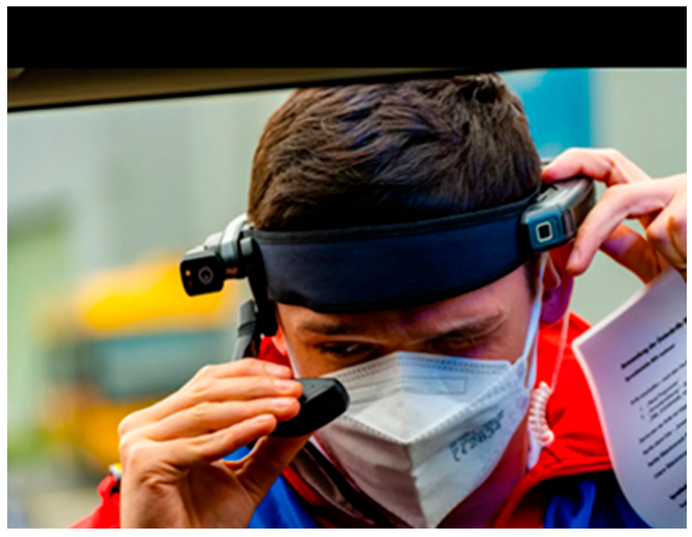
Figure 2.
Shows a burn-untrained first responder taking a picture with a camera for telemedical evaluation.
Figure 2.
Shows a burn-untrained first responder taking a picture with a camera for telemedical evaluation.
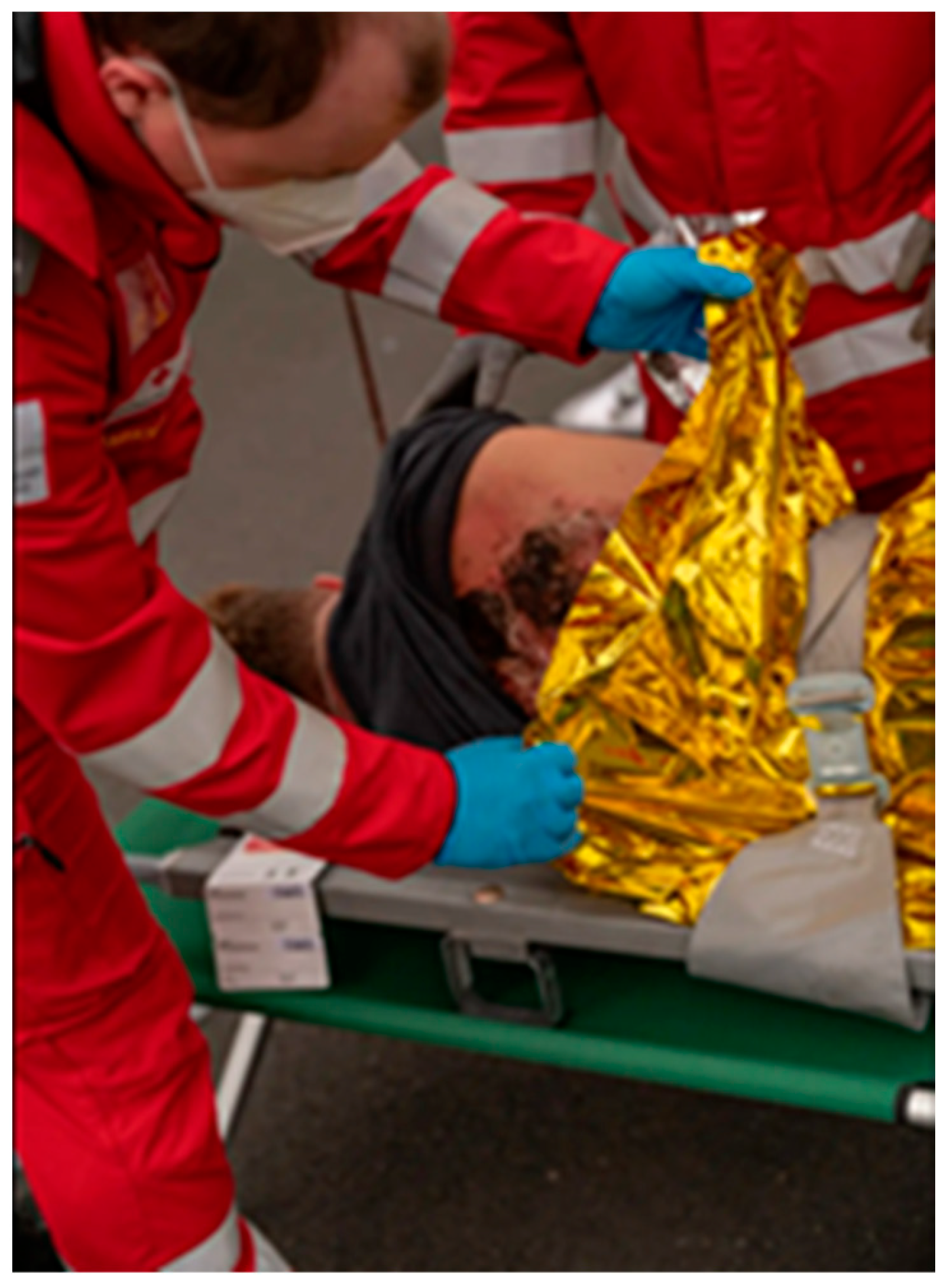
Table 1.
Tasks and progress.
| Tasks | Progress |
|---|---|
| Triage and Patient Assessment | AI can analyze patient symptoms, vital signs, and data to improve prioritization |
| Diagnostic assistance and decision support | Mostly provided with telemedicine support. AI-driven image analysis tools for interpreting radiological images, such as X-rays, CT scans, and MRIs. |
| Predictive Analytics with Common Data Elements (CDEs) | Can help to forecast future needs and potential bottlenecks by algorithms and machine learning. Allocation of medical staff, equipment, and facilities can be improved. |
| Telemedicine and Remote Support | Telemedicine can help in remote evaluation, diagnosis, and treatment guidance when medical expertise on-site is limited. Remote monitoring may help to identify urgent treatment needs. |
| Integration of Traditional & Modern Methods | Combine modern technology with traditional strategies, including local assessment, hazard identification, safe transport routes, and triage-based search and rescue operations. |
| Training and Simulation | Provide simulation-based training to healthcare professionals and responders to prepare them for a variety of scenarios and familiarize them with new technological tools. |
| Continuous Improvement and Feedback | Implement an iterative approach by continuously collecting feedback, analyzing outcomes, and refining strategies and technologies to adapt to real-world performance and changing demands. |
| Situational Awareness | Awareness of all aspects of the disaster as it unfolds to allocate resources appropriately. A central registry aids in determining optimal outcomes, while tools mapping patient locations, demographics, and injury severity are crucial. Mathematical modeling predicts patient influx, and social media data harvesting offers real-time updates. Weather and geospatial monitoring provide additional data, with interstate or international cooperation utilized when local capacities are exceeded. |
| Research and data analysis | AI can analyze huge amounts of medical data. Machine learning can lead to new insights and advancements, which have to be verified before generalization. |
Table 2.
Diverse information from different sources.
| Technology | Description |
|---|---|
| Artificial Intelligence (AI) | Advanced computing systems that mimic human intelligence to aid in decision-making and problem-solving. |
| Internet of Things (IoT) | Network of interconnected devices that can collect and exchange data, enabling real-time monitoring and analysis. |
| Mobile diagnostic applications | Smartphone or tablet applications designed to assist in medical diagnosis and monitoring, often leveraging sensors and connectivity for data collection. |
| Cloud-based platforms | Online platforms that provide storage, processing power, and other computing resources accessible over the internet, facilitating collaboration and data sharing. |
Disclaimer/Publisher’s Note: The statements, opinions and data contained in all publications are solely those of the individual author(s) and contributor(s) and not of MDPI and/or the editor(s). MDPI and/or the editor(s) disclaim responsibility for any injury to people or property resulting from any ideas, methods, instructions or products referred to in the content. |
© 2024 by the authors. Licensee MDPI, Basel, Switzerland. This article is an open access article distributed under the terms and conditions of the Creative Commons Attribution (CC BY) license (http://creativecommons.org/licenses/by/4.0/).
Copyright: This open access article is published under a Creative Commons CC BY 4.0 license, which permit the free download, distribution, and reuse, provided that the author and preprint are cited in any reuse.


