Submitted:
15 March 2024
Posted:
18 March 2024
You are already at the latest version
Abstract
In the former mining district of La Carolina (southern Spain), waste materials were accumulated without first waterproofing the substrate. Additionally, these mining dams were abandoned without any type of restoration, conditions that present a significant risk of contaminating the surrounding soils and waters. Prior to carry out the necessary works for isolating these residues, morphological characterization of the contact with the base substrate is needed. For that purpose, in recent years, different indirect study techniques have been used, among which electrical to-mography stands out. In this work, a less common geophysical technique, magnetometry, both in its magnetic and gra-diometric modalities, is used as an alternative method to analyse the geometry and structure of a mining dam. The results obtained with this methodology are compared with the results provided by electrical techniques, as well as with direct data from mechanical surveys and aerial photo-graphs prior to waste deposition. The magnetic anomaly curves obtained with geometric models generated with the Mag2dc program were also analysed. This comparative study shows the use-fulness of magnetic prospecting in characterizing the base geometry of these mining structures and therefore the interest in its application to environmental characterization studies.
Keywords:
Tailings dams
; Environmental risk
; Magnetometry
; Magnetic susceptibility
; La Carolina mining district
; Spain
1. Introduction
Until a few decades ago, the enormous volume of waste generated in mining districts (tailings, flotation sludge, foundry slag, etc.) were accumulated near the facilities without any type of corrective measures. Furthermore, at the time of mine closure, planning measures that involved isolation of these waste accumulations had not been considered. Under these conditions of exposure to the atmosphere, oxidation of the sulphides present in the waste produced very negative consequences for the environment due to the leachate generation with high contents of sulphates and certain metallic elements, which are processes that have been described worldwide in different abandoned mining districts [1,2,3].
At present, this environmental problem suggests the need to take corrective actions, among which are those aimed at isolating these deposits to avoid precipitation infiltration. Thus, it is very important to know both the geometry of the base and the internal structure of these mining tailings. To characterize these mining dams, numerous studies have used indirect methods (geophysical methods) because they are useful and fast for reconstructing shape, identifying areas of recharge and discharge, and determining the morphology of the contacts between the residues and substrate. Among these methods, electrical tomography (ERI) is the most widely used and has been demonstrated as effective in different mining districts [4,5,6,7,8,9,10,11].
As mentioned, electrical tomography is a very useful technique with a high vertical resolution. However, the need to use numerous electrodes, as well as to assemble and disassemble the entire device, makes field work laborious and time-consuming. In practice, this is a limitation that means many of the studies carried out do not obtain many profiles. This results in a lower horizontal resolution in the interpretation of the results. For this reason, this work analyses the use of magnetometry as an alternative method because with this technique, the data acquisition is very fast, and numerous profiles can be obtained over short periods of time. However, there is no examples in the literature describing its use for characterizing this type of mining structures.
In this study, the metallogenic district of La Carolina (southern Spain, province of Jaen, Figure 1), which is characterized by the presence of phylonian deposits, consisting mainly of galena (PbS), was chosen. These mineralizations have historically been the object of intense exploitation and were abandoned at the end of the 1960s. The abundance of these deposits favoured the development of important underground mining for centuries, and this activity produced a large quantity of tailings, which were deposited near the extraction works [12]. As described in different studies [13,14,15], in this mining area, there is also an environmental degradation related to potentially toxic elements (PTEs) that affects the quality of water and soils, similar to those previously mentioned in other sectors.
2. Geological and Mining Context of the Study Area
The La Carolina mining district is located on the southeastern slope of Sierra Morena, on the southeastern limit of the Hesperian massif [16,17]. From a regional point of view, it is possible to differentiate the existence of two large sets of materials: a Palaeozoic basement and a posthercynian sedimentary cover. The Palaeozoic basement consists of a succession of metasedimentary rocks (mainly phyllites and quartzite) of Ordovician to Carboniferous age [18,19] intruded by a granite at the end of the Hercynian Orogeny [20]. The posthercinian cover, which is arranged subhorizontally and in discordance over the Paaleozoic basement, appears fossilizing the mineralizations. It is exclusively composed of Triassic, Miocene and Quaternary materials.
The origin of the phylonian field in La Carolina is associated with the extensional conditions and the anomalous geothermal gradient originated at the end of the Hercynian Orogeny. These mineralizations are of hydrothermal origin, where the fluid phase and the metals were injected through the fractures and discontinuities in the granite mass and the Palaeozoic host rocks. The paragenesis of the ore primarily consists of galena, with minor proportions of sphalerite, chalcopyrite and pyrite. Quartz, ankerite and calcite predominate as gangue [19].
In this work, one of the largest waste accumulations stored in the mining district, known as La Manzana, was selected (Figure 1). It is a tailings dam with a size of approximately 250x400x20 m and a waste volume of approximately 2,000,000 m3 (Figure 2a), and its deposits rest directly on Silurian phyllites. This waste accumulation occupies a basin through which an old stream runs, and the runoff waters are channelled through a pipe at the bottom of the dam. The mining waste consists of the fine reject material generated in the galena ore concentration process via the flotation method. The structure was built by upstream regrowth from a small dam of coarse materials. The discharge system consisted of a gutter (by gravity) in the outline of the structure, and the drainage system consisted of a lateral chimney, which was still preserved (Figure 2b), and PVC drain pipes connected to the bottom pipe. There is a drainage gallery at the foot of the dam (Figure 2c), which discharge is maintained throughout the year, even in the dry season. It corresponds to the saturated zone of the dump and the drainage of an old mine adit buried under the mining wastes [15]. The magnetic studies conducted in this work were carried out on the tailings that fossilize all these structures and currently have a totally horizontal morphology of the ceiling (Figure 2d).
3. Previous Studies
The La Manzana dam has been the subject of previous studies related to the analysis of the contamination potential of mining wastes [5,15]. In these works, two boreholes were drilled in the central area of the dam to reach the metamorphic substrate. The first borehole was drilled with a triple battery to obtain an unaltered continuous core that enabled the acquisition of samples for granulometric, geochemical and mineralogical analysis. In addition, sensors for measuring humidity, electrical conductivity, temperature and dissolved oxygen were installed at different depths. This net of sensors enabled the variations in these parameters to be recorded over more than a decade, and the evolution of the geochemical processes within this tailings dam was analysed. The second borehole is used as a piezometer for measuring the water table and taking water samples in the saturated zone of the dump. The soundings cut the phyllites at 27.50 m during drilling. This direct information is used as correlation data with indirect research techniques. The depth of this contact, together with the information provided by the old aerial photographs prior to the construction of this dam, are essential tools for the adequate interpretation of geophysical prospecting profiles (Figure 3).
Geochemical characterization of the sediments indicated that this sludge pool had high concentrations of PTEs, such as Pb (8000 mg/kg), Zn (5000 mg/kg), and As (500 mg/kg). In addition, these tailings present pH values of approximately 8 due to the presence of additives, such as CaCO3, that are used for the extraction of galena. On the other hand, in the lower part of the piezometer, approximately 90 cm of water saturation occurs. The analyses revealed very high contents of SO42- (> 2900 mg/L), and dissolved Fe (> 27 mg/L) and Mn (> 4 mg/L) in this water [15].
In relation to the resistivity studies, Figure 3 shows an electrical tomography profile performed for this dam [5]. Two sets can be differentiated in the vertical direction: a more superficial one, with generally low-medium resistivity values, which is associated with the tailings of the sludge dam or a highly altered substrate. In the lower part, there is another set characterized by increasing resistivity values, which is related to the phyllites of the unaltered substrate. The contact between the two bodies is more defined in dry season than in wet season, where it appears diffuse. The phyllites are very altered, so they have an important secondary porosity, and in humid periods, they can become saturated in water. This saturation favours a decrease in resistivity values and, therefore, makes them similar to the waste dam [5].
On the other hand, increases in resistivity are detected at the NW end of the dam within the tailings. These high values could be due to the presence of the peripheral dykes used for the regrowth of the waste dams (indicated as dyke in Figure 3c). Laterally, decreases in resistivity are also associated with an increase in the degree of humidity. In Figure 3, if the position of the old ravine is compared with the position of the electrical tomography profile (Figure 3b) and the minimum resistivity values recorded in this study (Figure 3c), a great coincidence is observed. Thus, at approximately 220 m, the ERI profile passes through the old ravine, and it is precisely in this vertical where the minimum resistivity values are recorded (less than 4 Ωm).
4. Materials and Methods
Magnetic prospecting is based on the detection of local variations (anomalies) in the Earth’s magnetic field. These anomalies are caused by the presence of materials with different magnetic susceptibility values. Therefore, they can be polarized by the influence of the Earth’s magnetic field [21]. As a previous step in the interpretation of the magnetometer measurements taken in the field, it is necessary to subtract the main field (the amount that is expected to exist in that place and in that moment) as well as the influence of the external fields (in this case study, only the diurnal correction). This methodology has been extensively described in the literature [21,22,23].
Magnetic prospecting is a widely used tool in different Earth science fields. In this sense, it is worth highlighting its great utility in mining and, specifically, in the prospecting of ferromagnetic elements [24,25,26,27]. In addition, it has been used to carry out geological mapping in heavily covered areas [28,29], hydrocarbon prospecting sites [30], archaeological prospecting sites [31,32], and location of sinkholes or shallow holes [10,33,34]. However, to date, it has not been used for the characterization of mining dams.
In this study, field work was conducted with the portable magnetic/gradient equipment model GSMP-35G v8.0 Potassium from the GEM System (Figure 2d). This potassium magnetometer offers high data quality due to its high sensitivity (0.0003 nT), minimum reading error, resolution (0.0001 nT) and high precision (+/- 0.05 nT).
The main field was obtained through calculations made by the geomagnetic reference field IGRF 13 (https://geomag.bgs.ac.uk/data_service/models_compass/igrf_calc.html). For the calculation of the external field, the observatory of San Pablo, near Toledo, was used as a base station (Toledo, Spain; https://www.ign.es/web/gmt-magneto-san-pablo).
The measurement with the mobile magnetometer consisted of tracing a path of 21 parallel profiles in the SW‒NE direction, with continuous measurements in walking mode and a separation between the profiles of approximately 15 m (the distance was conditioned by the presence of vegetation that hindered data collection). To obtain field and magnetic gradient values, two sensors were used simultaneously, separated by 1 m (Figure 2d). Given the stability of the equipment used, measurements were taken every 50 ms in each of these profiles. Georeferencing was conducted with a NovAtel GPS device mounted on top of the mobile device (Figure 2d).
To study the behaviour of the magnetic susceptibility, magnetic susceptibility values of various types of rocks from the substrate and mining residues were measured in the outcrops. The equipment used was a portable hand-held susceptometer, model Terraplus KT-10.
In the office, the analysis of the magnetic anomalies, diurnal correction and despiking were carried out using the GEMLink program. The Surfer program was used for the representations and data kriging analysis.
5. Results and Discussion
5.1. Magnetic Prospecting
In Figure 4, four of the twenty-one profiles obtained from the dam are shown, and their positions are indicated in Figure 5 (profiles 4, 6, 8 and 14). In each of profile, the anomaly of the total magnetic field (expressed in nT) and the magnetic gradient (expressed in nT/m)
are represented. When the total magnetic field profiles and the vertical magnetic gradient profiles that appear in the respective figures are compared, no major differences are detected. The trends in the curves are very similar, although the magnitude of the anomaly can change.
In profile 4, very similar trends are observed when comparing the magnetic and gradiometric values, highlighting a minimum in the values in the SW sector (beginning of the profile), precisely coinciding with the smallest thickness of the dam. Towards the NE, the thickness of the dam fill increases, and in parallel, the magnetic anomaly increases.
This same trend is observed in profile 6, with minimum values at the beginning of the profile that coincide with the periphery of the dam (SW sector), increasing the thickness and the anomaly towards the NE. At 132 m from the origin, a very significant, narrow and steep anomaly is observed, which is detected in both magnetic and gradiometric modes and coincides with the position of the borehole.
In profile 8, a maximum is observed in the magnetic anomaly approximately 80 m from the origin. If the position of this maximum in Figure 4 is compared with that of the ravine (Figure 3 and Figure 5), they coincide. From this point forward, the thickness of the dam decreases due to the height of the substrate, as shown in Figure 3a. This decrease in thickness is correlated with the decrease in the anomaly in the final part of profile 8 (Figure 4).
In relation to profile 14 (Figure 4), in the initial part, the magnetic and gradiometric curves present different trends. This would be conditioned by the channelling of the stream waters: these buried structures affect the measurements in gradiometric mode more and therefore generate anomalies in this curve that are not as evident in magnetic mode. In the second half of the profile, the magnetic anomaly decreases due, in this case, to the presence of an area of greater relief in the northern sector of the substrate of the dam.
Figure 5 shows two anomaly maps (magnetic anomaly in Figure 5a and gradiometric anomaly in Figure 5b) on a digital image from Google Earth. These distribution maps were prepared with the Surfer program using the total of the registered profiles. The figure also indicates the position of the old channel, as well as that of the four profiles discussed above. A comparison of these two images with those in Figure 3a and b reveals that the negative anomalies measured in the North sector coincide with the elevation of the substrate in Figure 3a. The same would occur with the negative anomalies in the southern sector, which coincide with the southern limit of the dam, where there is another topographic high, which conditions the decrease in the thickness of the fill. Therefore, there is a correlation between the magnetic anomaly and the thickness of the sediments in the mining dam.
5.2. Magnetic Susceptibility
In total, 20 magnetic susceptibility measurements were carried out on Silurian phyllites in the immediate area near the dam. The values range from 0.136x10⁻³ to 0.101x10⁻³ SI, with an average of 0.117 SI.
A similar number of susceptibility measurements were also obtained from the waste in the dam. The values vary between 0.140 and 0.160 SI, with an average of 0.150 SI, which is higher than that obtained for the substrate rocks. The measurements were always taken in the superficial part of the tailings and, therefore, above the oxidant front. However, the sensors installed in the borehole at different depths and the study of the obtained cores indicate that from approximately 8 m depth, the materials are under reducing conditions up to the base of the borehole (at this point, up to a depth of 27.50 m). Under these reducing conditions, which constitute nearly the entire tailings impoundment, higher concentrations of magnetic minerals and therefore higher susceptibility values are expected [39].
5.3. Modelling of Mag2dc Profiles
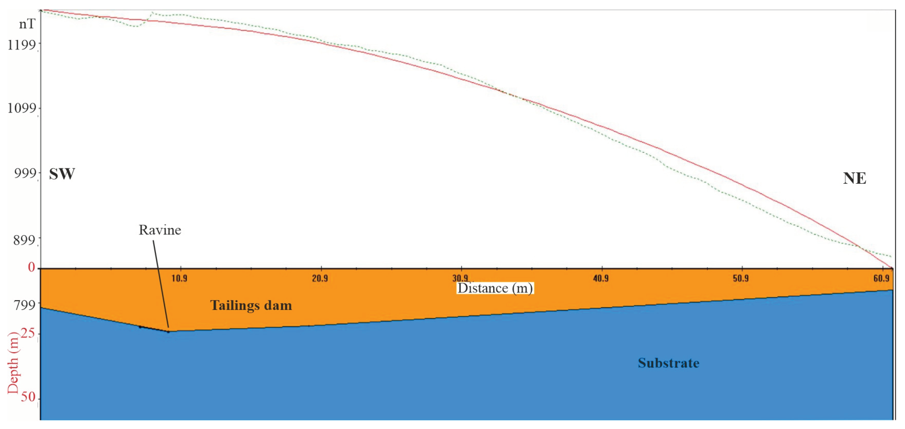
Figure 3a shows the position of the buried ravine under the mining dam. In the same figure, to the north of this ravine, the presence of a high area that coincides with the negative magnetic anomaly of Figure 5 is found. One of the profiles obtained in the field was selected (Profile 14, Figure 4 and Figure 5), which passes through the ravine and the top of the substrate, and modelling of the magnetic anomaly curve of the profile was carried out using Mag2dc software. In Figure 6, the values obtained in the field for this profile are represented by a green dashed line, and the resulting magnetic anomaly curve from the modelling is represented by a solid red line. In this model, the phyllite basement is considered to have a slightly lower magnetic susceptibility than the dam wastes. The geometry of the basement included in the model is irregular: at the beginning of the profile (SW sector), it is at higher elevations, coinciding with the periphery of the dam. At approximately 10 m from the origin and coinciding with the ravine, the lowest point is located. From this point, the substrate rises towards the top of the NE sector.
The top of the waste dam is flat and horizontal in this profile; however, its base is irregular because it adapts to the morphology of the substrate. With this geometry, as deduced from the field information and the orthophoto prior to the mining dam, the model shown in Figure 6 was constructed. As seen in the graph, the values of the field curve and the modelled curve fit quite precisely. This finding confirms that negative magnetic anomalies are associated with the height of the substrate, thus allowing the identification of variations in the morphology of the base of the mining dam.
6. Conclusions
In this work, different geophysical methods (electrical and magnetic methods), old orthophotos, direct information from mechanical boreholes and direct data taken from outcrops are integrated and compared to analyse the capacity of magnetometry in the modelling of geological structures with mining implications. Specifically, the ability of these methods to deduce the base geometry on which an old flotation sludge dam was deposited is studied. For this purpose, the old mining district of La Carolina (southeastern Spain), where the Philonian deposits of galena were exploited, was chosen.
This study has made it possible to establish a correlation between magnetic anomalies and changes in the accumulation thickness of mining wastes. As the roofs of these tailings dams are flat surfaces, the changes in thickness are directly related to irregularities in the roof of the rocky substrate. This result was verified by comparing the magnetic anomaly curves obtained in the field with the theoretical curves obtained with the proposed geometric model, which were calculated using the Mag2dc program. This comparative study shows the usefulness of magnetic prospecting in characterizing the base geometry of these mining structures and, therefore, its application to environmental characterization studies.
Author Contributions
Conceptualization, R.M. and J.R.; methodology, R.M, J.R. and M.C.H., statistical analysis and software, R.M.; investigation, R.M., J.V., J.R. and M.C.H.; writing original draft, J. Rey; writing - review & editing, M.C.H. and J. Rey. All authors have read and agreed to the published version of the manuscript.
Funding
Grant PID2021-123506OB-I00 funded by the MICIU/AEI/ 10.13039/501100011033 and ERDF/EU. The study was partly funded by the University of Jaen.
Data Availability Statement
The data that support the findings of this study are available upon request from the corresponding author, J.R.
Conflicts of Interest
The authors declare that they have no conflicts of interest that could have inappropriately influenced this work.
References
- Sobanska, S.; Ledésert, B.; Deneele, D.; Laboudigue, A. Alteration in soils of slag particles resulting from lead smelting. Comptes Rendus de l'Academie des Sciences-Series IIA-Earth and Planetary Science 2000, 331, 271. [Google Scholar] [CrossRef]
- Li, X.; Thornton, I. Chemical partitioning of trace and mayor elements in soils contaminated by mining and smelting activities. Applied Geochemistry 2001, 16, 1693–1706. [Google Scholar] [CrossRef]
- Chopin, E.I.B.; Aloway, B.J. Trace element partitioning and soil particle characterization around mining and smelting areas at Tharsis, Ríotinto and Huelva, SW Spain. Science of the Total Environment 2007, 373, 488–500. [Google Scholar] [CrossRef]
- Martínez-Pagán, P.; Cano, F.; Aracil, E.; Arocena, J.M. Electrical Resistivity Imaging Revealed the Spatial Properties of Mine Tailing Ponds in the Sierra Minera of Southeast Spain. J. Environ. Eng. Geophys. 2009, 14, 63–76. [Google Scholar] [CrossRef]
- Martínez, J.; Rey, J.; Hidalgo, M.; Garrido, J.; Rojas, D. Influence of measurement conditions on the resolution of electrical resistivity imaging: The example of abandoned mining dams in the La Carolina District (Southern Spain). Int. J. Miner. Process. 2014, 133, 67–72. [Google Scholar] [CrossRef]
- Martínez, J.; Hidalgo, M.; Rey, J.; Garrido, J.; Kohfahl, C.; Benavente, J.; Rojas, D. A multidisciplinary characterization of a tailings pond in the Linares-La Carolina mining district, Spain. J. Geochem. Explor. 2016, 162, 62–71. [Google Scholar] [CrossRef]
- Zarroca, M.; Linares, R.; Velásquez-López, P.C.; Roqué, C.; Rodríguez, R. Application of electrical resistivity imaging (ERI) to a tailings dam project for artisanal and small-scale gold mining in Zaruma-Portovelo, Ecuador. J. Appl. Geophys. 2015, 113, 103–113. [Google Scholar] [CrossRef]
- Rey, J.; Martínez, J.; Hidalgo, M.C.; Mendoza, R.; Sandoval, S. Assessment of Tailings Ponds by a Combination of Electrical (ERT and IP) and Hydrochemical Techniques (Linares, Southern Spain). Mine Water Environ. 2020, 40, 298–307. [Google Scholar] [CrossRef]
- Rey, J.; Mendoza, R.; Martínez, J.; Hidalgo, M.; Rodríguez, C.F. Combining geophysical methods (DC, IP, TDEM and GPR) to characterise mining waste in the Linares-La Carolina district (southern Spain). J. Environ. Manag. 2022, 322. [Google Scholar] [CrossRef]
- Mendoza, R.; Marinho, B.; Rey, J. GPR and Magnetic Techniques to Locate Ancient Mining Galleries (Linares, Southeast Spain). Int. J. Geophys. 2023, 2023, 1–11. [Google Scholar] [CrossRef]
- Oliveira, L.A.; Braga, M.A.; Prosdocimi, G.; Cunha, A.d.S.; Santana, L.; da Gama, F. Improving tailings dam risk management by 3D characterization from resistivity tomography technique: Case study in São Paulo – Brazil. J. Appl. Geophys. 2023, 210. [Google Scholar] [CrossRef]
- Gutierrez-Guzmán, F. Minería en Sierra Morena. Ilustre Colegio de Ingenieros Técnicos de Minas de Linares, Granada, Jaén y Málaga 2007.
- Hidalgo, M.C.; Benavente, J.; El Mabrouki, K.; Rey, J. Estudio hidroquímico comparativo en dos sectores con minas abandonadas de sulfuros metálicos: distrito de Linares-La Carolina (Jaén). Geogaceta 2006, 39, 123–126. [Google Scholar]
- Hidalgo, M.C.; Rey, J.; Benavente, J.; Martínez, J. Hydrogeochemistry of abandoned Pb sulphide mines: the mining district of La Carolina (southern Spain). Environ. Earth Sci. 2009, 61, 37–46. [Google Scholar] [CrossRef]
- Rojas, D. Influence of Mine Wastes on the Water Resources in the La Carolina Mining District (Jaen). Ph. D. Thesis University of Jaen, Jaén, Spain, 2019.
- Julivert, M.; Fontboté, J.M.; Ribeiro, A.; Conde, L.E. Mapa tectónico de la Península Ibérica y Baleares, E. 1:1.000.000, Memoria Explicativa. IGME 1972.
- Tamain, G. Recherches géologiques et minières en Sierra Morena orientale (Espagne). Thesis Univ. Paris-Sud (Orsay). Trav. Lab. Géol. Struct. Appli. 91- Orsay 1972, 648 pp.
- Fontboté, J.M. Mapa geológico y memoria explicativa de la hoja 70 (Linares), escala 1:200.000. Instituto Geológico y Minero de España 1982.
- Lillo, J. Geology and Geochemistry of Linares-La Carolina Pb-Ore field (Southeastern border of the Hesperian Massif). Ph. D. Thesis, Univ. Leeds 1992.
- Castelló, R.; Orviz, F. Mapa y memoria explicativa de la hoja nº 884 (La Carolina) del mapa Geológico de España, escala 1:50.000. Instituto Geológico y Minero de España 1976.
- Blakely, R. Potencial Theory in Gravity and Magnetic Applications. Cambridge University Press 1995, 441 p.
- Telford, W.M.; Geldart, L.P.; Sheriff, R.E. Applied Geophysics, Cambridge University Press 1990, 770 p.
- Reynolds, J.M. An Introduction to Applied and Environmental Geophysics. John Wiley and Sons Ltd., UK 2011, 796 p.
- Abedi, M.; Fournier, D.; Devriese, S.G.; Oldenburg, D.W. Integrated inversion of airborne geophysics over a structural geological unit: A case study for delineation of a porphyry copper zone in Iran. J. Appl. Geophys. 2018, 152, 188–202. [Google Scholar] [CrossRef]
- Granda Sanz, A.; Granda París, T.; Pons, J.M.; Videira, J.C. El descubrimiento del Yacimiento de la Magdalena. Protagonismo de los métodos geofísicos en la exploración de yacimientos tipo sulfuros masivos vulcanogénicos (vms) profundos en la faja pirítica ibérica. Boletín Geológico y Minero 2019, 130, 213–230. [Google Scholar] [CrossRef]
- Fries, M.; Zago, M.M.; da Silva, F.G. A geophysical study contributing to analysis and characterization of a localized copper occurrence. J. Appl. Geophys. 2020, 179, 104129. [Google Scholar] [CrossRef]
- Carvalhêdo, A.L.d.C.; Carmelo, A.C.; Botelho, N.F. Geophysical-geological model of the Pedra Branca massif in the Goiás Tin Province, Brazil. J. South Am. Earth Sci. 2020, 101, 102593. [Google Scholar] [CrossRef]
- Nabighian, N.M. Electromagnetic method in Applied Geophysics. Tulsa, Okla. Society of Exploration Geophysics 1988, 971 p.
- Alva-Valdivia, L.M.; Guerrero-Díaz, P.; Urrutia-Fucugauchi, J.; Agarwal, A.; Caballero-Miranda, C.I. Review of magmatic iron-ore mineralization in central-western Mexico: Rock-magnetism and magnetic anomaly modelling of Las Truchas, case study. J. South Am. Earth Sci. 2019, 97, 102409. [Google Scholar] [CrossRef]
- Okiwelu, A.A.; Obianwu, V.I.; Ohara, E.E.; Ude, I.A. Magnetic anomaly patterns, fault-block tectonism and hydrocarbon related structural features in the Niger Delta basin. IOSR J. Appl. Geol. Geophys. 2014, 2, 31–46. [Google Scholar] [CrossRef]
- Pueyo-Anchuela, O.; Diarte-Blasco, P.; García-Benito, C.; Casas-Sainz, A.M.; Pocoví, J. A. Geophysical and archaeological charaterization of a modest Roman villa: methodological considerations about progressive feedback analyses in sites with low geophysical contrast. Archaeological Prospection 2016, 23, 105–123. [Google Scholar] [CrossRef]
- Murín, I.; Neumann, M.; Brady, C.; Bátora, J.; Čapo, M.; Drozd, D. Application of magnetometry, georadar (GPR) and geoelectrical methods in archaeo-geophysical investigation of a Napoleonic battlefield with fortification at Pressburg (Bratislava, Slovakia). J. Appl. Geophys. 2022, 196. [Google Scholar] [CrossRef]
- Mochales, T.; Pueyo, E.L.; Casas, A.M.; Soriano, M.A. Magnetic prospection as an efficient tool for doline detection. A case study in the central Ebro Basin (Northern Spain). Geological Society of London. Special Publications 2005, 279, 73–84. [Google Scholar] [CrossRef]
- Martínez-Moreno, F.; Galindo-Zaldívar, J.; Pedrera, A.; Teixido, T.; Ruano, P.; Peña, J.; González-Castillo, L.; Ruiz-Constán, A.; López-Chicano, M.; Martín-Rosales, W. Integrated geophysical methods for studying the karst system of Gruta de las Maravillas (Aracena, Southwest Spain). J. Appl. Geophys. 2014, 107, 149–162. [Google Scholar] [CrossRef]
- Grauch, V.J.S.; Hudson, M.R. Aeromagnetic anomalies over faulted strata. Geophysics 2011, 30, 1242–1252. [Google Scholar] [CrossRef]
- García, J.C.; García, P.C.; Sanchiz, D.P.; Nieto, I.M.; Blázquez, C.S.; Hurtado, P.H. Drone Magnetic and Time Domain Electromagnetic Exploration in Metamorphic Formations: Tool for the Identification of Strategic Sites for Aquifer Exploitation. Appl. Sci. 2023, 13, 10949. [Google Scholar] [CrossRef]
- Cooper, G. Forward modelling of magnetic data. Comput. Geosci. 1997, 23, 1125–1129. [Google Scholar] [CrossRef]
- Anwar, H.; Ipmawan, V.L.; Sriyakul, T. Geophysical Analysis Using Proton Precession Magnetometer GSM-19T as Information on Fault Presence in Medana, North Lombok, Indonesia. Int. J. Hydrol. Environ. Sustain. 2022, 1, 8–23. [Google Scholar] [CrossRef]
- Orgeira, M.J.; Walther, A.M.; Tófalo, O.R.; Vásquez, C.A. , Berquó, T.S.; Favier Dobois, C.; Bohnel, H. Environmental magnetism in fluvial and loessic Holocene sediments and paleosols from the Chacopampean plain (Argentina). Journal of South American Earth Sciences 2003, 16, 259–274. [Google Scholar] [CrossRef]
Figure 1.
(a) Location of the studied region. (b) Details on the position of the La Manzana dam in the study area.
Figure 1.
(a) Location of the studied region. (b) Details on the position of the La Manzana dam in the study area.

Figure 2.
Photographs. (a) General view of the tailings dam. (b) Upper part of the chimney drain installed in the dam. (c) Details of the drainage at the foot of the dam. (d) Field procedure used for magnetic data collection.
Figure 2.
Photographs. (a) General view of the tailings dam. (b) Upper part of the chimney drain installed in the dam. (c) Details of the drainage at the foot of the dam. (d) Field procedure used for magnetic data collection.
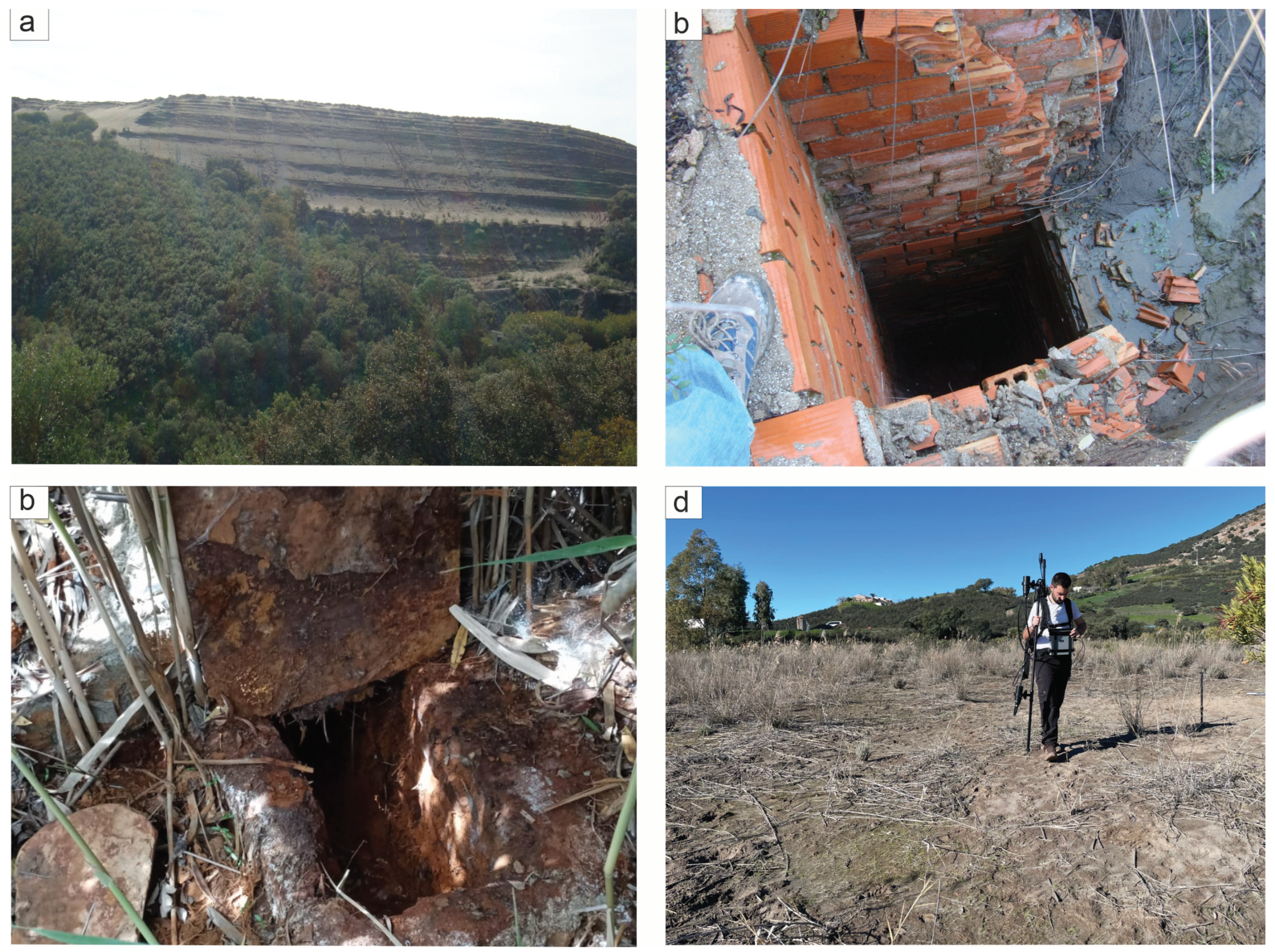
Figure 3.
(a) Orthophoto from 1956-1957, obtained prior to construction of the dam. The limits of the upper part of the dam are indicated in red, the outline of the old ravine is indicated in blue, and the position of the electrical tomography profile is indicated in white. (b) Current satellite image of the dam, in which the positions of the old ravine, the electrical tomography profile (electrical resistivity imaging, ERI), and the borehole are indicated. (c) Electrical tomography profile modified from [5].
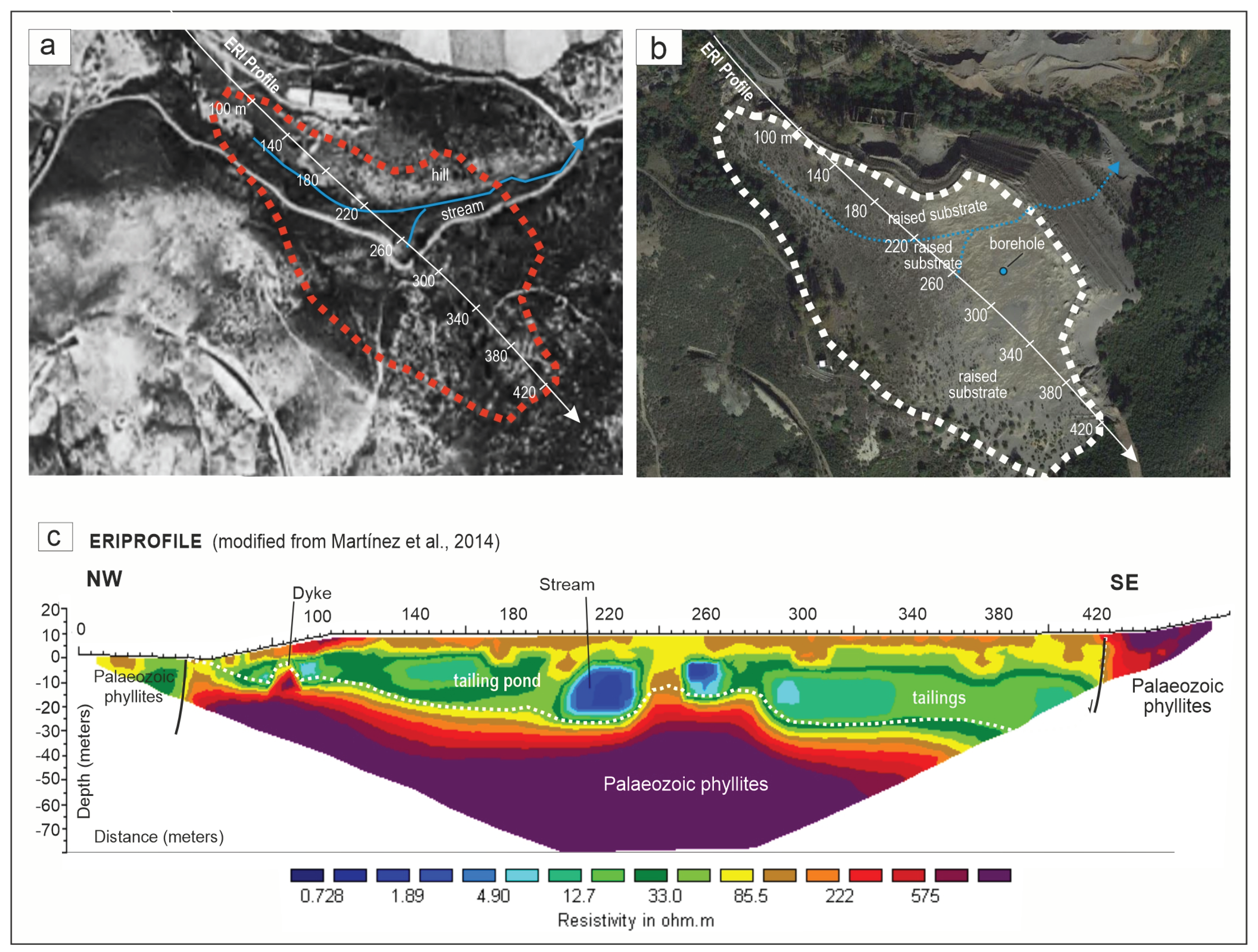
Figure 4.
Graphs representing four of the profiles created for the dam (profiles 4, 6, 8 and 14). The positions of each component are shown in Figure 5. For each of these profiles, both the magnetic anomaly (blue line) and the magnetic gradient (brown line) are represented.
Figure 4.
Graphs representing four of the profiles created for the dam (profiles 4, 6, 8 and 14). The positions of each component are shown in Figure 5. For each of these profiles, both the magnetic anomaly (blue line) and the magnetic gradient (brown line) are represented.
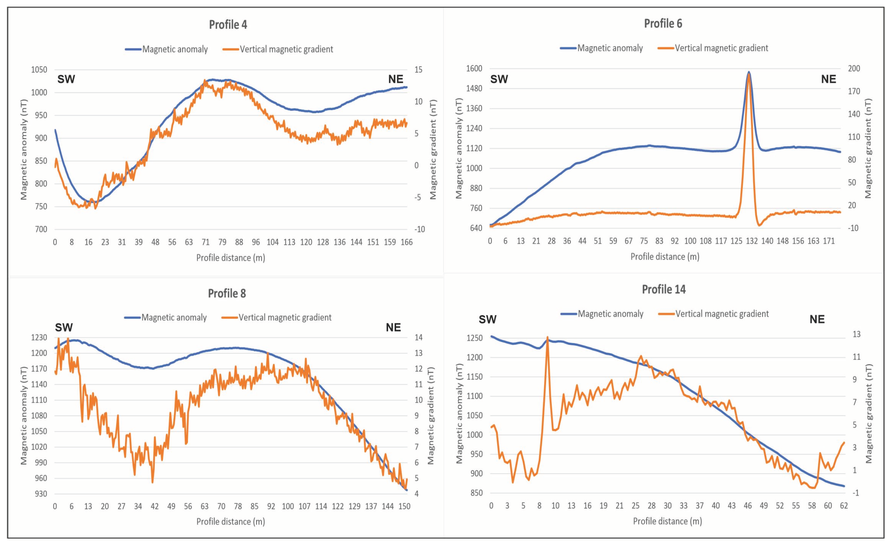
Figure 5.
Anomaly map of the total magnetic field (a) and the magnetic gradient (b) on the current satellite image of the dam. The position of the old ravine is indicated (blue dashed line), and the four profiles are represented in Figure 4 (P4, P6, P8 and P14).
Figure 5.
Anomaly map of the total magnetic field (a) and the magnetic gradient (b) on the current satellite image of the dam. The position of the old ravine is indicated (blue dashed line), and the four profiles are represented in Figure 4 (P4, P6, P8 and P14).
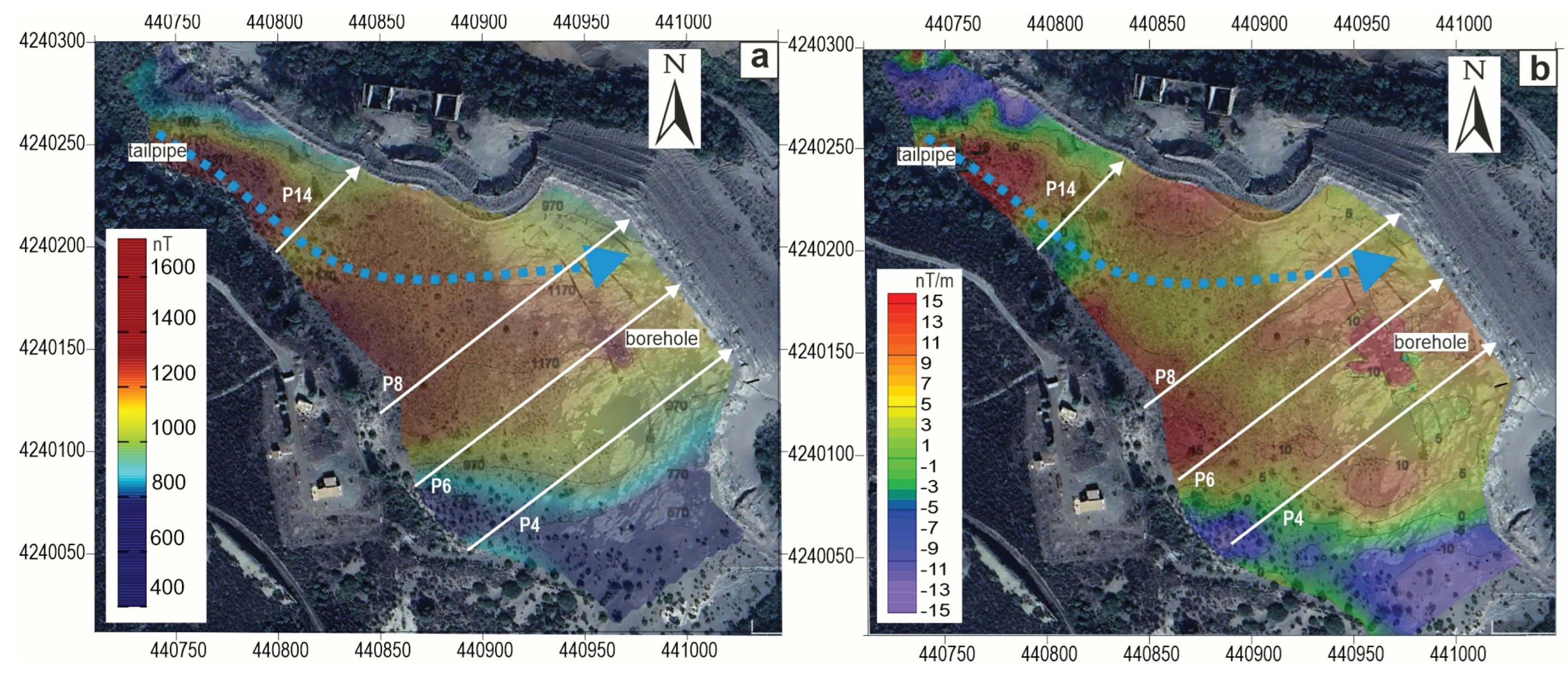
Figure 6.
Comparison of the total magnetic anomaly curve measured in profile 14 (green dashed line) and the curve obtained by the Mag2dc software for the considered substrate model (red line). The position of the ravine is indicated.
Figure 6.
Comparison of the total magnetic anomaly curve measured in profile 14 (green dashed line) and the curve obtained by the Mag2dc software for the considered substrate model (red line). The position of the ravine is indicated.
Disclaimer/Publisher’s Note: The statements, opinions and data contained in all publications are solely those of the individual author(s) and contributor(s) and not of MDPI and/or the editor(s). MDPI and/or the editor(s) disclaim responsibility for any injury to people or property resulting from any ideas, methods, instructions or products referred to in the content. |
© 2024 by the authors. Licensee MDPI, Basel, Switzerland. This article is an open access article distributed under the terms and conditions of the Creative Commons Attribution (CC BY) license (http://creativecommons.org/licenses/by/4.0/).
Copyright: This open access article is published under a Creative Commons CC BY 4.0 license, which permit the free download, distribution, and reuse, provided that the author and preprint are cited in any reuse.


