Submitted:
06 December 2023
Posted:
07 December 2023
You are already at the latest version
Abstract
There has been a rapid increase in the use of Marine Spatial Planning (MSP) throughout the world recently, partly due to the continued loss of marine biodiversity and habitat. The sustainability of marine resources is threatened in all regions of the world by major events such as climate change, marine pollution, overfishing, illegal, unreported and unregulated fishing both on the high seas and in country waters. Here, we present a comprehensive review and analysis of how economic information has been applied and used to inform decisions about MSP in British Columbia (BC), Canada and other similar jurisdictions. This focus for the paper was selected because important gaps remain in the literature in terms of incorporating economic questions into MSP. We first present different definitions of MSP, and then we extract useful lessons from MSP regimes with well–tested decision support tools, and use this to guide MSP implementation in BC. We finally present and discuss case studies from Australia, South Africa and Belgium. Our review suggests that applying economic information to support the design and implementation of MSPs would lead to better decisions. This in turn would foster livelihoods, attract finance, increase buy–in and advance United Nations Sustainable Development Goal 14: Life Below Water, thereby achieving Infinity Fish, i.e., ensuring that ocean benefits flow to humanity forever.
Keywords:
marine spatial planning
; decision support tools
; economic analysis
1. Introduction
Amidst growing threats posed by climate change and pollution in our oceans, the expanding utilization of marine zones for diverse activities like fishing, transportation, and recreation holds the potential to detrimentally impact the habitats of marine life, biodiversity, and the vital food security of numerous coastal communities worldwide. Consequently, this issue has ignited a heightened consciousness regarding the imperative for responsible management of marine areas, both within national jurisdictions and on the high seas (Sumaila et al. 2015; Waldron et al. 2020). Over the past two decades, Marine Spatial Planning (MSP) has become one of the most widely adopted management approaches used to address serious damage to marine areas while improving the well–being of people whose livelihoods are directly linked to these areas. When adopting MSP strategy, policymakers typically identify a variety of reasons, ranging from environmental, biological, political, socio–economic, and national security.
In this contribution, we focus on the economic aspects of the decision–making process and make a twofold contribution to the literature. First, we investigate how economic issues are integrated into MSP efforts in British Columbia (BC), Canada, and other similar jurisdictions. Second, we examine how this economic information has been applied and used to inform MSP decisions. Thus far, there has been little discussion about incorporating economic information in MSP, therefore, our goal is to fill this gap by addressing the following key questions: 1) are value–added from MSP analyzed quantitatively? 2) how do you assess the contributions (i.e., jobs, income) of the various sectors of MSP? and 3) are the spatial and temporal allocation of marine scarce resources analyzed?
The rest of the paper is organized as follows: Section 2 outlines the general context of the study and definition of MSP. Section 3 introduces the methodology of the study while Section 4 presents a literature review on economic and social perspectives. Section 5 explains how economic questions are incorporated into MSP efforts. Section 6 discusses the results of the review. Section 7 concludes the paper. Finally, the appendix features summary tables for each question, together with case studies from Australia, South Africa and Belgium.
2. General Context of the Study and MSP Definition:
Marine Spatial Planning (MSP) is an approach used to manage and allocate the various activities and uses of marine and coastal areas in a systematic and sustainable manner. It involves the spatially and temporally explicit allocation of scarce marine spaces, resources, and services to competing uses, and the governance framework that designs, implements, and monitors these allocations. MSP is employed by the public sector to investigate and distribute human activities in marine areas over time and space to achieve specific objectives set forth in policy narratives. The Great Barrier Reef and Canada are recognized for their pioneering efforts in MSP (Day 2016). The Australian government introduced the Marine Park Act 1975 to safeguard coral reefs, while Canada’s Oceans Act, established in 1996, governs the country’s national waters and has generated numerous regulations governing marine protected areas, fishing zones such as marine aquaculture, and the coordination of the territorial sea (Craig 2019). MSP aims to respond to increasing pressures on ocean space, support blue growth, preserve important marine zones, resolve conflicts in densely occupied ocean areas, and achieve sustainable development (The World Bank 2022; Ehler 2021).
This paper highlights key features of MSPs, including policy mechanisms, mandates, and regulations, in Canada and comparable jurisdictions. It discerns both similarities and distinctions in MSP policies and regulations across six developed countries, as outlined in Table A1 in the Appendix A.
MSP can also be defined from an economic perspective as the explicit allocation of scarce marine spaces, resources, and services to competing uses, along with the governance framework that implements and monitors this allocation. It is a process employed by the public sector to investigate and distribute human activities in marine areas over time and space to achieve specific policy objectives. MSP is used by countries like Vietnam and China to achieve economic and environmental objectives (Ehler and Douvere, 2009). The concept of MSP has evolved over time, with a focus on it being a continuous effort rather than a one-time action (Ehler 2021). Various countries articulate their official MSP definitions, as consolidated in Table A2 in the Appendix A.
The definition of Marine Spatial Planning (MSP) has evolved over time and has been influenced by different stages of its development. Initially, MSP was loosely referred to under various terminologies in the history of fisheries science as elucidated in Table A3 of the Appendix A. When applied at an ecosystem level, it represents a practical approach that moves toward ecosystem-based management of marine areas. Ehler and Douvere (2009) emphasized the importance of assessing the current status of marine areas and the tools that can be used to achieve specific goals, rather than focusing solely on the desired status. It is important to note that Marine Protected Areas (MPAs) and MSPs, while closely related, are distinct concepts with separate definitions. MPAs can support the implementation of MSPs, but they can also be implemented independently to achieve various economic, biological, and environmental objectives. An MSP is a broader framework that includes MPAs, which in turn includes zoning (Borges et al. 2020). Economic assessments have played a significant role in evaluating the value of various marine activities, contributing to the design and management of MPAs by considering the economic costs and benefits associated with conservation measures (The World Bank 20221).
Figure 1 shows the three key stages in the use of economics in the MSP process. First, economics provides an understanding of the current state of the stock in terms of biomass, catches, landed values, etc. These bio–economic indicators form powerful tools for assessing the state of the marine zone, particularly in terms of overfishing and environmental degradation. This provides initial crucial information necessary for developing a successful MSP. Next, there are a multitude of decision–support tools (DSTs), such as cost–benefit analysis (CBA) and input–output analysis, which are used to support the development and implementation of the fisheries management strategy. Finally, economics can be used to help steer the MSP towards the desired outcomes.
3. Methodology
The research aims to describe the questions addressed by economic methods and approaches in the MSP process. The study conducted a comprehensive survey of peer-reviewed and grey literature, focusing on literature directly relevant to the use of economic information to inform MSP decisions. The research focused on jurisdictions similar to British Columbia, Canada, which have initiated or fully implemented MSPs, based on economic development indicators such as Gross Domestic Product (GDP) and the United Nations Human Development Index (HDI). The analysis primarily targeted developed economies and their national jurisdictions. The study did not depict the temporal progression of MSPs but provided a snapshot of available options to date, considering literature published after 2002, considering that MSPs gained academic recognition in the decades leading up to the year 2000, with the majority of relevant literature emerging post-2000, coinciding with the implementation of the Australian Great Barrier Reef Marine Parks Act (1975).
The review aimed to identify the main socio-economic information relevant to MSP and the range of research questions answered by economic methods and approaches in the selected jurisdictions (The World Bank 2022). The World Bank provides an overview of economic approaches and tools that can strengthen the economic case for MSP. It argues that adding robust economic analysis to the MSP process can increase buy-in, foster livelihoods, attract finance, and advance the long-term Blue Economy objective of protecting the ocean’s resources and ecosystems. The paper emphasizes the spatially and temporally explicit allocation of scarce marine resources and services to competing uses, and the governance framework that designs, implements, and monitors this allocation. It also highlights the importance of understanding the economic trade-offs associated with MSP and the potential of a sustainable ocean economy (The World Bank 2022). The European Maritime Spatial Planning Platform discusses research on socio-economic aspects of MSP, focusing on methodologies and approaches used in other projects (EU MSP Platform 2018).
4. Economic and Social Aspects of MSP
4.1. Main Socio–Economic Aspects Included in MSP
In a recent review conducted by Chalastani et al. (2021), the strong interconnection between ecosystems and Marine Spatial Planning (MSPs) was emphasized, drawing on the ecosystem-based management approach (Douvere 2009; Crowder and Norse 2008; Gilliland et al. 2008; White et al. 2012; Lester et al. 2013; Arkema et al. 2015). This underscores the pivotal significance of interactions within an ecosystem, not only for MSPs but also for other spatial planning strategies (Longato et al. 2021).
The integration of human activities into MSPs involves a critical aspect: defining undertakings within the marine environment. Socio-economic factors considered typically include traditional pursuits such as fishing, shipping, transportation, and tourism, alongside emerging sectors like offshore wind energy, mariculture, dredging, mineral extraction, and biodiversity conservation. MSPs often encompass elements such as land use and zoning, social indicators (e.g., population, age, measures of livelihood sustainability), and economic parameters (employment, monthly income per inhabitant) (Suris–Regueiro et al. 2021a, 2021b; Fernandes et al. 2022).
Over recent decades, MSPs have evolved from simple zoning plans to complex, integrated, adaptive, multiple-use planning (Douvere and Ehler 2009; Ehler 2021). Important regulatory changes, such as the European Union (EU) Directive 2014/89/EU on MSP, have significantly shaped these initiatives (Schaefer and Barale 2011; Buhl–Mortensen et al. 2017; Friess and Gremaud–Colombier 2021).
The European Maritime Spatial Planning Platform highlights the importance of incorporating socio-economic aspects into MSP to reduce or avoid conflicts between economic and non-economic functions and pressures. It also emphasizes the need to consider socio-economic information in MSP data and assessment tools, land sea interactions, and MSP for blue growth, as well as the challenges and recommendations for integrating socio-economic input into ecosystem-based MSP (Fernandes et al. 2022].
The World Bank provides a comprehensive and integrated investment framework for the Blue Economy through MSP, aiming to reduce investment risk, improve investor certainty, and address environmental and social issues. The World Bank’s guidance note on "Applying Economic Analyses to Marine Spatial Planning" offers tools and data for a robust economic analysis of the MSP process, highlighting the potential benefits of such analyses in fostering livelihoods, attracting finance, and drawing financing for marine projects within a Blue Economy (The World Bank 2022).
The literature highlights a challenge in MSP, where socio-economic aspects are not consistently considered, with a predominant focus on environmental dynamics. However, recent developments indicate a growing prominence of social aspects in MSP considerations. Concepts such as social sustainability, social equity, social dimensions, and ocean justice are gaining recognition, supported by case studies in various regions (Flannery et al. 2016; Frederiksen et al. 2021; Gilek et al. 2021; Saunders et al. 2020; Bennett et al. 2020, 2021; Issifu et al. 2023; Maini et al. 2023; Grimmel et al. 2019; Baker et al. 2020). Despite the breadth of the subject matter, Table 4 provides examples of the socio-economic aspects addressed in the analyzed case studies.
4.2. Different Uses of Socio–Economic Aspects in MSP
Social and economic aspects can be included in the MSP for different purposes and in different stages, such as planning, development, maturation and implementation. To include these aspects, multiple strategies can be followed and DSTs can be used.
The active involvement of all stakeholders in the planning process stands as a central strategy for effectively incorporating socio-economic aspects into Marine Spatial Planning (MSP), a subject extensively examined by (Pomeroy and Douvere, 2008). From the engagement of local actors to navigating conflicts among influential entities, including both companies and governments, the convergence of stakeholders presents one of the most intricate challenges for MSP. A Danish case study by Ramírez–Monsalve and van Tatenhove in 2020 underscores the importance of understanding power dynamics within MSP, shedding light on how these dynamics shape winners and losers. Through discursive analysis of planning-related documents, regulations, and news reports, the study unveils the mechanisms of power at play and their impact on the MSP process. Notably, the study highlights those sectors capable of providing more data gain power advantages due to the emphasis on data acquisition and stringent timelines.
Another case study, focusing on the Northeast Ocean Planning process in the US, particularly in Massachusetts Bay, emphasizes the imperative to assess the democratic and inclusive nature of MSP processes to ensure effective participatory engagement (Flannery et al. 2018). Kirkfeldt et al.’s 2020 study delves into the deeply ingrained traditions and values within planning teams, referred to collectively as planning culture, across three Northern European countries (Denmark, Norway, and Germany), elucidating how planning culture influences MSP. Case studies further scrutinize stakeholders’ social and economic values and perceptions concerning new marine environment situations, such as the introduction of human-made structures (Elrick–Barr et al. 2022).
The socio-economic dimensions are not only considered during planning and evaluation but also play a crucial role in monitoring phases. A framework of analysis, as analyzed by Buhl–Mortensen et al. in 2017 through the EU-funded MESMA project, facilitates monitoring and evaluation in diverse marine areas across Europe.
Cross-border resources management poses a unique challenge in MSP, requiring the harmonization of different political, economic, and social perceptions and objectives across multiple jurisdictions. Papers by Ehler and Douvere in 2009, Albotoush and Shau–Hwai in 2023, Kull et al. in 2021, and Ansong et al. in 2021 explore various aspects of transboundary MSP, such as defining management authorities, establishing international good practices, and providing evaluation frameworks for institutional integration.
Numerous case studies shed light on specific initiatives related to cross-border cooperation, including the SINMORAT project in Spain, Portugal, and France (Gómez–Ballesteros et al. 2021), transboundary MSP in the Bay of Biscay (Pinarbasi et al. 2020), and collective action in Baltic Sea MSP (Hassler et al. 2018). These initiatives offer insights into challenges and solutions related to social acceptability, ecological and social/management scale mismatches, and joint risk assessments.
A critical aspect of MSP involves securing adequate funding for establishment and management. Economic analysis plays a crucial role in attracting funding, considering long-term policies and financial sustainability throughout planning, monitoring, evaluation, and revision phases. Funding sources range from government budgets and private sector financing to innovative mechanisms like blue bonds, foundation funds, and trusts. The importance of aligning funding mechanisms with MSP objectives is emphasized to ensure financial support and sustainable implementation.
Incorporating new activities into marine space, such as marine renewable energies, is a significant challenge addressed through various case studies. These studies analyze factors such as anticipating pressures on ocean energy, legal challenges and opportunities, institutional barriers, planning priorities in a climate neutrality era, and local stakeholder opposition.
4.3. Socio–Economic Aspects in the MSP Decision Support Tools
In the context of MSP, the effective utilization of Decision Support Tools (DSTs) is crucial due to the dynamic nature of maritime space and the diverse interests and conflicts among stakeholders. Pinarbasi et al. (2017) conducted a comprehensive global review, analyzing 34 DSTs employed in 28 MSP initiatives. The findings revealed varying levels of complexity, applicability, and challenges such as limited functionality, tool stability, costs, and the consideration of economic and social decision problems. DSTs should address spatial and temporal dynamics, be multifunctional, user-friendly, and freely accessible. Geospatial DSTs, utilizing technologies like GIS/Spatial Analytics, Global Navigation Satellite System, Earth Observation, and others, play a central role in data collection, planning, and environmental monitoring.
Depellegrin et al. (2021) explored the impact of regulatory frameworks, specifically the Directive on MSP, on spatial and non-spatial DST development. The study highlighted the importance of addressing challenges related to uncertainty and incorporating artificial intelligence. Geospatial technologies, encompassing various tools such as LiDAR, Radar, and Sonar, are essential for the development of DSTs.
DSTs are instrumental in data collection, planning, and monitoring, encompassing socio-economic aspects for detecting areas of specific human uses and pressures. They facilitate the development and comparison of alternative scenarios for identifying ’least-cost’ solutions and conducting benefit-cost analysis for management measures.
The use of DSTs relies on cumulative impacts assessments (CIA) or cumulative effects assessments (CEA). Challenges include avoiding double counting and addressing complexities and confounding impacts. Innovative models, combining human pressure data and GIS platforms, provide visual representations to support decision-making.
Various methods, such as the Delphi Method, Soft Systems Methodology, and Bayesian modeling, are employed in MSP management. Initiatives like "ocean accounting (OA)" integrate economic information into MSP, organizing ocean information to support the integrated consideration of social, environmental, and economic values.
End-user perspectives on DSTs in MSP emphasize the importance of tool-user interaction and a publicly accepted MSP workflow. Users seek tools with multifunctionality, integrity, and ease of use. Challenges include the underrepresentation of socio-economic information in spatial data, often presented qualitatively and in non-spatial formats. To address these challenges, a participatory mapping approach is proposed, collecting stakeholders’ knowledge and opinions and translating them into spatial data for a comprehensive representation.
5. Application of Economics to Inform MSP Decisions
Examining the potential trade-offs between current and future competing uses of ocean space in monetary terms is integral to effective MSP. Cost and benefit estimation should encompass the full implications of MSP actions, incorporating intrinsic and nonmarket values (Sumaila 2021). Resource allocation in MSP often involves trade-offs, as a portion of marine space allocated to one activity, like a wind farm, may preclude allocation to other uses, such as oil extraction (European Commission, 2020). Economic desirability, from a social standpoint, is contingent upon overall benefits outweighing costs (European Commission 2020).
Policy-oriented economists utilize models of social conflict to explore how MSP can facilitate win-win situations and resolve conflicts among ocean users. An exemplary trade-off analysis focused on alternative ocean uses is the study by White et al. (2012) for the Massachusetts Ocean Management Plan. Their assessment of conflicts between offshore wind energy, commercial fishing, and whale-watching sectors revealed the potential for preventing losses to the incumbent fishery and whale-watching sectors while generating extra value for the energy sector through MSP (White et al. 2012).
Apart from cost and benefit analysis, economic tools like participatory assessment and spatial software packages such as Integrated Valuation of Environmental Services and Trade-offs (InVEST) are employed to assess MSP’s impact on biodiversity and ecosystem services. For instance, in Belize, InVEST was used to analyze trade-offs resulting from alternative Integrated Coastal Zone Management Plan scenarios, aiding decision-making in favor of informed management (Rosenthal et al. 2015).
Evaluating potential contributions to jobs and incomes generated by various MSP sectors involves using input-output economic tools. Taylor et al. (2015) utilized IMPLAN modeling systems to calculate the economic contribution of Washington State’s marine sectors, offering insights into the economic impacts of alternative scenarios on both the coastal region and the entire state. Adaptive management, recognized as crucial to MSP evolution, has been effectively employed in countries like China, Australia, Norway, Germany, Belgium, the Netherlands, and the United States (Frazão Santos et al. 2014, 2019).
An essential economic question focuses on MSP’s role in achieving Blue Economy goals. An impact pathway assessment helps identify critical policy entry points, as demonstrated by Alpizar et al. (2020), who assessed policy instruments to reduce agrochemicals or plastic waste in the ocean in Costa Rica.
Understanding the true costs and benefits of MSP implementation involves identifying beneficiaries and cost bearers under different scenarios. Considering the differentiated impact on indigenous groups, local communities, and businesses, as exemplified in Washington’s MSP process, helps reduce conflicts and enhances buy-in (Taylor et al. 2015).
Effectively evaluating MSP outcomes is crucial for design and implementation. Causal links between MSP and measurable outcome indicators should be established, considering impacts on poverty dimensions, livelihoods, food security, and wealth generation. Learning from the experience of evaluating Marine Protected Areas (MPAs), which has shown economic cases for public investments to improve biodiversity and economic development, can inform MSP evaluation strategies (Waldron et al. 2020, Dahmouni and Sumaila 2023).
6. Discussion
The slow pace of implementing Marine Spatial Planning (MSP) in some coastal jurisdictions can be attributed to various reasons, including financial and economic obstacles, administrative red tape, and the complex nature of MSP as part of a comprehensive jurisdictional strategy (Ehler 2021). Integrating economic issues into future MSPs presents several challenges, including the need to secure public funds and the consideration of long-term benefits versus short-term costs. Policymakers face the challenge of evaluating MSPs in the context of intergenerational considerations, which raises questions about the weight given to future generations in decision-making processes (Sumaila 2021).
Efforts to safeguard the world’s oceans are increasingly being emphasized at international meetings, particularly through the United Nations Sustainable Development Goals (SDGs). While SDG 14 (Life Below Water) is directly related to MSP, other goals such as clean water and sanitation, affordable and clean energy, decent work and economic growth, innovation, industry and infrastructure, and climate action are also relevant to MSP. MSP can be driven by SDG 14 and, in turn, can contribute to other goals involving diverse economic components. Additionally, recognizing multi-stakeholder communal use and stewardship of marine space, and the well-being of coastal communities, particularly marginalized groups, presents another challenge (Issifu et al. 2022). MSP needs to address the viability and sustainability of these communities and their subsistence needs. Economic and social questions have become increasingly relevant in MSP, encompassing not only traditional aspects such as fisheries or transport impacts but also broader issues such as social equity, redistributive capacity, and intangible culture. However, challenges remain, including incorporating long-term change through adaptive approaches and considering transboundary impacts. Technological advances and more participatory and inclusive processes can facilitate addressing these challenges. A better understanding of the costs and benefits, trade-offs, and distributive implications from a socio-economic perspective can guide policymakers, users, and governments in promoting a sustainable ocean economy. The application of economic information and analysis can also ensure that MSP receives sufficient financing for successful implementation (Sumaila et al. 2022). Despite the increasing global adoption of MSP, significant strides are required to bridge existing gaps in incorporating economic dimensions into planning processes.
7. Conclusions
The study aimed to evaluate the integration of economic questions into Marine Spatial Planning (MSP) efforts in British Columbia, Canada, and similar jurisdictions. It analyzed the economic tools used by managers to apply economic information to inform MSP decisions. The study discussed practical economic questions and tools to incorporate economic information within MSP, highlighting the importance of Decision Support Tools (DSTs) in MSP and the attention given to incorporating economic questions. It identified input-output analysis and Cost-Benefit Analysis (CBA) as the most commonly used methods for estimating the economic impacts of implementing MSP. For example, input-output economic tools are used to estimate the total economic contributions, including indirect and induced impacts of marine sectors. The study demonstrated how each economic tool can be utilized to address potential gaps in MSP, while acknowledging the limitations of these tools (such as marine sectoral disaggregation, overestimations, and trade-off estimations) and the need to complement analyses with qualitative approaches. The review emphasized that applying economic information to support the design and implementation of MSPs would lead to better decisions, foster livelihoods, attract finance, and advance the long-term blue economy goals of conserving the oceans’ resources and ecosystems.
Appendix A

Table A1.
Key features of MSPs (e.g., policy mechanism, mandate, regulation, transparency) in Canada and similar jurisdictions2.
Table A1.
Key features of MSPs (e.g., policy mechanism, mandate, regulation, transparency) in Canada and similar jurisdictions2.
| Canada | The US | The UK | Belgium | Australia | Germany | |
|---|---|---|---|---|---|---|
| National plan | No | No | No | Yes | No | No |
| Regional or state plan | Southern BC; Pacific North Coast; Newfoundland & Labrador shelves; Estuary and Gulf of St. Lawrence; and Scotian Shelf and bay of Fundy. |
Northeast Ocean Plan; Massachusetts Ocean Management Plan; Mid–Atlantic Regional Ocean Action Plan; Rhode Island Ocean Special Area Management Plan; Draft Marine Spatial Plan for Washington’s Pacific Coast and Oregon Territorial Sea Plan. |
East Inshore and East; South Inshore and South Offshore Marine Plans (England); Offshore Marine Plans (England); Scotland’s National Marine Plan; Welsh National Marine Plan and Marine Plan for Northern Ireland. |
Belgian Part of the North Sea; Flanders. | Great Barrier Reef Marine Park Zoning Plan; Marine Bioregional Plan for the North–west Marine Region; Marine Bioregional Plan for the South–west Marine Region; Marine Bioregional Plan for the North Marine Region; South–east Regional Marine Plan; Marine Bioregional Plan for the Temperate East Marine Region. |
Maritime Spatial Plan for the Exclusive Economic Zone (EEZ) of the North Sea; Maritime Spatial Plan for the EEZ of the Baltic Sea; State Development Plan for Schleswig– Holstein; Spatial Planning Programme of Lower Saxony; and Spatial Development Programme of Mecklenburg– Vorpommer. |
| Responsible ministry at regional plan | Minister of Fisheries and Oceans. | Regional Advisory Committees. |
Marine Management Organization with regional marine management plans. | The Belgian minister for the North Sea | Regional Marine Plans under Commonwealth environment department. | Ministry of Energy, Infrastructure and Digitalization (Mecklenburg– Vorpommer). |
| Focus area | Environmental protection and economic development. | Manage conservation and biodiversity (e.g., Northeast Ocean plan). | Sustainable development. | Improve management of the Belgian Part of the North Sea. | Support environmental protection and maritime economy. | Support maritime economy and environmental protection. |
| Legal binding | Ocean Act is non–binding. | Mandated. | Not legally binding. | Royal Decree. | Mandated. | General Spatial Planning Act |
| Environment assessment | Cabinet Directive on Strategic Environmental Assessment. | Strategic Environmental Assessment. | Strategic Environment Assessment. |
Table A2.
Official definition of MSP in different jurisdictions3.
Table A2.
Official definition of MSP in different jurisdictions3.
| Country | Authority | Official terminology | Official Definition |
|---|---|---|---|
| Canada | The department of Fisheries and Oceans Canada (DFO) | Marine spatial planning | Marine spatial planning is a process for managing ocean spaces to achieve ecological, economic, cultural and social objectives. We advance marine spatial planning in Canada in collaboration with other federal departments, provincial, territorial and Indigenous governments as well as relevant stakeholders. |
| USA | The National Oceanic and Atmospheric Administration (NOAA) | Coastal and Marine Spatial Planning | A compilation of geospatial data to create a national framework for coastal and marine spatial planning, complete with data, tools, and information to bolster transparent, science–based decision–making to enhance regional economic, environmental, social, and cultural well–being. |
| England | Marine Management Organisation | Marine planning |
|
| Norway | Government of Norway | Integrated ocean management plans | The purpose of the management plans is to provide a framework for value creation through the sustainable use of marine natural resources and ecosystem services and at the same time maintain the structure, functioning, productivity and diversity of the ecosystems. |
| Belgium, Bulgaria, Croatia, Cyprus, Denmark, Estonia, Finland, France, Germany, Greece, Ireland, Italy, Latvia, Lithuania, Malta, Netherlands, Poland, Portugal, Romania, Slovenia, Spain, Sweden | European commission4 | Marine spatial planning |
|
Table A3.
The evolution of MSP.
| Stage | Description | Key Features |
|---|---|---|
| Initial Phase (e.g., Vietnam Danang Master Plan Towards 2030). | – Emerged in the late 20th century as a response to increasing conflicts over marine resource use. – Informal and ad –hoc approaches to managing marine space. – Limited integration of environmental considerations. |
– Reactive management. –Lack of coordination among stakeholders. – Focus on sector –specific regulations |
| Development Phase (e.g., Ecuador’s Galapagos Marine Reserve Management Plan). | – Late 1990s to early 2000s saw the emergence of formal MSP frameworks. – Recognition of the need for holistic and integrated management of marine space. – Growing emphasis on stakeholder engagement and participatory processes. |
– Identification of marine planning areas. – Assessment of marine resources and uses – Integration of ecological, social, and economic considerations – Stakeholder involvement and public participation. |
| Maturation Phase (e.g., Australia EEZ, including Norfolk Island). | – Mid –2000s onwards witnessed the maturation of MSP as a recognized management approach. – Increasing adoption of MSP at national and regional levels. – Emphasis on ecosystem –based management and sustainability principles |
– Integration of ecosystem –based approach. – Strategic goals and objectives for marine management. – Development of marine spatial plans and zoning systems. – Incorporation of adaptive management and monitoring. – Emphasis on cross –sectoral coordination. |
| Implementation Phase (e.g., E.g., Belize (TS) Integrated CoastalZone Management Plan, Norway (EEZ and TS). | – Current phase focused on the practical implementation of MSP. – Emphasis on plan implementation, monitoring, and evaluation. – Iterative process to learn and adapt over time. – Continued engagement with stakeholders and adaptive management |
– Implementation of marine spatial plans. – Monitoring of ecological and socioeconomic indicators. – Review and revision of plans based on feedback and changing conditions. – Integration with existing governance structures and policies. |
Note: Territorial seas (TS).
Table A5.
a) Are trade-offs with monetized values analyzed quantitatively?
| Economic decision support tools (DST) | Scenarios analysis |
| Uses of DST | Provides management scenarios and guide management to develop their own solutions. Provides a set of structured information to aid in decision-making and analysis. |
| Country/MSP | USA, European Union, Australia. E.g., Scenario planning has been used in Australia for MSP efforts, such as the Great Barrier Reef Marine Park, which considered scenarios of climate change, population growth, and land use changes to guide conservation and management strategies. |
| Limitation | Scenario planning can be resource-intensive, requiring significant time, expertise, and financial investment to develop, analyze. Unreliable data can constrain the effectiveness of the process. |
| Data intensive level | High: Data on environmental conditions, socioeconomic indicators, policy frameworks, and other relevant factors. |
| Output variable | Plausible future scenarios, visualizations of spatial and temporal changes, impact assessments, and identification of key vulnerabilities and opportunities. These outputs inform decision-making by providing a range of potential future outcomes and their associated implications for MSP. |
| References | Hassan and Alam 2019, Beck et al. 2009, World Bank 2022b, Collie et al. 2013. |
Source: Authors creation based on literature reviewed.
Table A5.
b) Does the trade-off analysis consider market and non-market (e.g., ecosystem service value) economic components?
Table A5.
b) Does the trade-off analysis consider market and non-market (e.g., ecosystem service value) economic components?
| Economic decision support tools (DST) | InVEST, complement with cost-Effectiveness analysis. |
| Uses of DST | InVEST supports the evaluation of trade-offs between different management options. |
| Country/MSP | China, Costa Rica, Colombia. E.g., InVEST has been employed in China for MSP, including the Beibu Gulf region, to evaluate the impacts of different management scenarios on multiple ecosystem services, such as fisheries production, and coastal protection. |
| Limitation | The accuracy of InVEST outputs can be influenced by the scale and resolution of the input data such as ecosystem characteristics, land use, hydrology, and socioeconomic factors. |
| Data intensive level | High: Geospatial data on ecological characteristics, economic indicators, and ecosystem services. |
| Output variable | Spatial maps and models depicting the distribution and value of ecosystem services, trade-off analyses, and valuation of ecosystem services.These outputs contribute to the identification of priority areas for conservation. |
| References | Sun et al. 2020; Halpern et al. 2010; World Bank 2021. |
Source: Authors creation based on literature reviewed.
Table A5.
c) How do you assess the contributions (i.e., jobs, income) of the various sectors of MSP?
Table A5.
c) How do you assess the contributions (i.e., jobs, income) of the various sectors of MSP?
| Economic decision support tools (DST) | Input-output analysis. |
| Uses of DST | Quantifies the socioeconomic importance of marine sectors in the total economy of a country or region. |
| Country/MSP | German, Norway, Australia, The United States, The United Kingdom. E.g., The German Baltic Sea has utilized input-output analysis in MSP initiatives, to assess the economic linkages and impacts of marine sectors, such as fisheries, aquaculture, and tourism. |
| Limitation | Input-output analysis assumes a static economic structure, not accounting for innovation, dynamic changes, or future market conditions. Data gaps can affect the accuracy and reliability of the analysis. |
| Data intensive level | High. Detailed economic data, such as input-output tables, sectoral data on production, employment, and value-added, as well as data on intersectoral linkages and transactions. |
| Output variable | The output variables can include employment impacts, economic multipliers, value-added effects, and the assessment of direct and indirect effects of changes in the marine sector on the overall economy. |
| References | Surís-Regueiro et al. 2021 ; Huang et al. 2015. |
Source: Authors creation based on literature reviewed.
Table A5.
d) Are value-added from MSP analyzed quantitatively?
| Economic decision support tools (DST) | The efficiency frontier. |
| Uses of DST | Allows comparison of very different ecosystem services, for example, MSP increased whale sector values by up 5% at no cost to the offshore wind energy. |
| Country/MSP | Massachusetts Ocean Management Plan (USA). |
| Limitation | The identification of the efficiency frontier can be influenced by subjective choices, such as the selection of indicators, and weighting factors. |
| Data intensive level | Medium. Data on resource allocation, management effectiveness, desired outcomes or indicators, and spatial patterns of activities or ecosystem components. |
| Output variable | Outputs may include optimal resource allocation, efficiency scores. The identification of management strategies or spatial plans that achieve desired outcomes most efficiently. |
| References | White et al. 2012. |
Source: Authors creation based on literature reviewed.
Table A5.
e) How can MSP help to achieve Blue Economic goals?
| Economic decision support tools (DST) | Cost-benefit analysis (CBA). |
| Uses of DST | CBA provides financial and social rationale for investing in the BE. |
| Country/MSP | CBA has been applied in MSP projects. In Indonesia, NPV of an Indonesian MPA was estimated as USD 3.55.0 million. |
| Limitation | Social and ecological aspects may be challenging to monetize. |
| Data intensive level | Economic data, market prices, valuation techniques. |
| Output variable | Net present value (NPV), benefit-cost ratio, economic impact assessments. |
| References | OECD, 2017; World Bank 2022. |
Source: Authors creation based on literature reviewed.
Table A5.
f) What are optimal conservation areas for MPA designs?
| Economic decision support tools (DST) | Marxan |
| Uses of DST | Designing MPAs and conservation planning. |
| Country/MSP | Marxan applied in the Great Barrier Reef Marine Park (Australia) to identify MPA designs that maximize conservation outcomes. |
| Limitation | Computationally intensive, sensitive to input parameters, and may not account for all stakeholder preferences. |
| Data intensive level | High: Biodiversity data, habitat maps, socioeconomic data. |
| Output variable | Optimal MPA configurations, conservation priorities, and cost-effectiveness analysis. |
| References | Watts et al. 2009. |
Source: Authors creation based on literature reviewed.
Table A5.
g) How do you integrate economic information or various data layers to inform MSP decision-making?
Table A5.
g) How do you integrate economic information or various data layers to inform MSP decision-making?
| Economic decision support tools (DST) | Geographic Information Systems (GIS). |
| Uses of DST | Spatial data management, visualization, and analysis. |
| Country/MSP | GIS used in the MSP process of the United Kingdom’s Marine Management Organization to integrate various data layers and inform decision-making. |
| Limitation | GIS requires georeferenced data, expertise in GIS software, and data quality control. |
| Data intensive level | Geospatial data on human activities, marine features, and habitats. |
| Output variable | Maps, spatial analysis results, and visualization. |
| References | EU MSP Platform 2018. |
Source: Authors creation based on literature reviewed.
Table A5.
h) How do you evaluate the trade-off between economic development and conservation objectives.
Table A5.
h) How do you evaluate the trade-off between economic development and conservation objectives.
| Economic decision support tools (DST) | SeaSketch. |
| Uses of DST | Interactive mapping and visualization tool for collaborative MSP. |
| Country/MSP | SeaSketch has been employed in the Magallanes Region (Chile), Massachusetts Ocean Management Plan (USA). |
| Limitation | The effectiveness of SeaSketch is dependent on the availability and quality of spatial data and active participation from stakeholders. |
| Data intensive level | High resolution data. Up-to-date datasets on marine ecosystems, habitats, species distributions, and socioeconomic factors such tourism revenue. |
| Output variable | Zoning plans, maps of potential impacts, cumulative impact assessments, and scenario-based visualizations. |
| References | Agardy 2015. https://legacy.seasketch.org/projects/ |
Source: Authors creation based on literature reviewed.
Table A5.
i) How do you estimate the economic value of ecosystem services provided?
| Economic decision support tools (DST) | Ecopath with Ecosim (EwE) is a software package used for ecosystem-based MSP. |
| Uses of DST | Impact assessment. EwE can simulate the effects of human activities, such as fishing, or climate change, on the marine environment and assess the potential ecological consequences. |
| Country/MSP | EwE has been utilized in South Africa for MSP, specifically in the Benguela Current region, to assess the impacts of different fishing scenarios on the ecosystem and inform management decisions. |
| Limitation | EwE requires extensive data on species interactions, population dynamics, fishing effort, and environmental variables. |
| Data intensive level | High. EwE models require comprehensive data on species composition, trophic interactions, life history parameters, fishing effort, environmental variables (e.g., temperature, productivity), and other relevant ecosystem characteristics. |
| Output variable | Estimates of species biomass, trophic interactions, fishing impacts, and indicators of ecosystem health. These outputs can guide decision-making in MSP. |
| References | Hamukuaya 2020. |
Source: Authors creation based on literature reviewed.
Table A5.
j) How do you assess possible conflicts among users of the ocean environment, and propose effective spatial management plans?
Table A5.
j) How do you assess possible conflicts among users of the ocean environment, and propose effective spatial management plans?
| Economic decision support tools (DST) | Multi-Criteria Decision Analysis (MCDA). |
| Uses of DST | Evaluating and comparing multiple criteria and alternatives in decision-making. |
| Country/MSP | MCDA applied in New Zealand’s MSP process to assess and prioritize different management scenarios based on ecological and socioeconomic criteria. |
| Limitation | Subjective weighting of criteria, stakeholder engagement challenges, and difficulty in quantifying certain criteria. |
| Data intensive level | High: Data on ecological, economic, and social factors, stakeholder preferences, and decision criteria. |
| Output variable | Evaluation scores, ranking of alternatives, and trade-off analysis. |
| References | Tuda et al. 2013 ; Zuercher et al. 2022. |
Source: Authors creation based on literature reviewed.
Table A5.
k) Governance: How do you incorporate new uses into MSP?
| Economic decision support tools (DST) | Marine Spatial Planning Support System (MSPSS). |
| Uses of DST | MSPSS can be used to incorporate new uses, such as renewable energy, aquaculture. |
| Country/MSP | South Africa, Australia, Norway. E.g., The South African MSPSS aids in incorporating various uses, such as offshore oil and gas exploration, marine tourism, into the MSP process. |
| Limitation | Stakeholder engagement and local context are crucial for effective use of MSPSS, and its effectiveness may vary depending on the level of stakeholder involvement. |
| Data intensive level | Regional-scale dataset such as spatial data on ecological features (habitats, species distributions), socioeconomic factors (e.g., human activities), and governance aspects (e.g., regulations, management measures). |
| Output variable | Spatial allocation of different uses (e.g., areas offshore wind farms). Quantitative assessments of the impacts of uses on ecological, socioeconomic, and governance factors. |
| References | Maes et al. 2005; Ehler and Douvere 2007. |
Source: Authors creation based on literature reviewed.
Table A5.
l) Governance: What are the most likely reactions of actors in marine space to the new regulations?
Table A5.
l) Governance: What are the most likely reactions of actors in marine space to the new regulations?
| Economic decision support tools (DST) | Probabilistic risk assessment (PRA), sensitivity analysis aiding environment risk assessment. |
| Uses of DST | Identifies the types of incentives needed for motivating highercompliance of regulations.Identify and quantify potential risks associated with marine activities, such as oil and gas exploration, shipping, or renewable energy installations. |
| Country/MSP | MSP scenarios in the German EEZ of the North Sea. Gulf of Mexico (USA) has employed PRA to evaluate risks from offshore energy development, spills, and natural hazards, and to inform decision-making processes for resource management. |
| Limitation | May not fully capture spatial and temporal variations in risks, particularly at finer scales or when considering dynamic changes in environmental conditions and human activities. |
| Data intensive level | Data on hazards (e.g., pollution sources), exposure (e.g., spatial distribution of activities), vulnerability (e.g., ecological sensitivity, socio-economic factors), and potential impacts. |
| Output variable | Risk estimates, probability distributions, sensitivity indices, and visualizations of potential impacts and their uncertainties. These outputs guide the development of risk management strategies. |
| References | Frazao Santo et al. 2013; Stelzenmuller et al. 2015. |
Source: Authors creation based on literature reviewed.
Table A5.
m) Governance: Is flexibility an explicit component of MSP?
| Economic decision support tools (DST) | Adaptive management (AM). |
| Uses of DST | AM helps reduce risks by allowing for adjustments and course corrections in response to unforeseen or unexpected outcomes. |
| Country/MSP | The Great Barrier Reef Marine Park (Australia), the Florida Keys National Marine Sanctuary (USA), and The Netherlands Integrated Management Plan for the North Sea. |
| Limitation | Adaptive management requires ongoing monitoring, data collection, analysis, and stakeholder engagement, which can be time-consuming and resource-intensive. |
| Data intensive level | Data or information gathered through stakeholder engagement processes, such as surveys, interviews, or participatory mapping. |
| Output variable | Publication of new scientific knowledge, best practices, or guidelines that emerge from the adaptive management process. |
| References | Ehler and Douvere 2009. |
Source: Authors creation based on literature reviewed.
Appendix B. MSP case studies
Early MSP initiatives are applied in marine conservation hotspots and environmental objectives are prominent (e.g., Great Barrier Reef in Australia). For the past two decades, MSP are concentrated in areas where economic objectives are more paramount with the aim of promoting sustainable development (GHK Consulting 2004). A case study approach is undertaken to illustrate and contextualize how economic questions are incorporated in recent MSP. The examples and case studies, however, are by no means exhaustive. The following considerations are based on what is addressed in the current literature as well as what emerged in the grey literature. As we have pointed out the importance of acknowledging context and recognizing jurisdictions similar to BC Canada. We draw some important economic questions which are related to MSP. The ways in which economic questions are integrated in MSP establishment are illustrated herein in the case studies of Gaufre Project in Belgium, South Africa and South-East Australia.
Case Study 1: Gaufre Project in Belgium
The Gaufre Project is an MSP initiative undertaken by the Belgian government to efficiently manage its marine resources and ensure sustainable economic activities in the North Sea. The project, named after the Belgian waffle aims to strike a balance between conservation efforts and the promotion of various economic activities within its Exclusive Economic Zone (EEZ). This case study explores the economic activities similar to BC in Canada, the conflicts that occurred during the planning process, the approaches used to resolve these conflicts, and the information needed for socio-economic planning and monitoring in the Gaufre Project.
The marine environment of Belgium’s North Sea, like BC’s coastal waters, supports a diverse range of economic activities. Some of the key activities similar to BC include: 1) Belgium’s North Sea supports a significant fishing industry, just like BC, which relies on various species of fish and shellfish for both domestic consumption and export. 2) The coastal regions of Belgium attract tourists for beach activities, water sports, and seaside leisure, similar to BC’s coastal tourism industry. 3) Both regions are interested in harnessing the potential of offshore renewable energy sources, such as wind farms, to reduce dependence on fossil fuels and mitigate climate change. 4) Belgium’s North Sea hosts important shipping lanes and ports, handling trade and commerce similar to BC’s port activities. 5) Conservation and protection of marine biodiversity and ecosystems are critical in both regions due to the ecological importance of their marine habitats.
During the MSP process, several types of conflicts emerged: 1) Spatial overlap - conflicts arose when different economic activities, such as fishing grounds and offshore wind farm sites, overlapped, leading to competition for limited marine space. For instance, the application for a wind turbine construction and operation concession by Seanergy sparked a major conflict between offshore wind energy producers and a coalition of local inhabitants, coastal municipalities, and environmental NGOs. These groups had differing visions for the use of marine space (Pecceu et al. 2016). 2) Use vs. Conservation conflicts: Another prominent conflict category arises from the tension between utilization and conservation. Activities that may require restrictions or even prohibition within certain marine areas, such as the approval of the Marine Environmental Protection Act, generated conflicts between the federal government and associations of fishermen, ship-owners, recreational fisheries, and local politicians (Jones et al. 2016). In response to these conflicts, the Belgian Government has adopted various approaches to facilitate resolution and ensure sustainable marine spatial planning: 1) Appointment of a Minister of the North Sea. In 2003 (and again in 2011), the government appointed a dedicated Minister of the North Sea with a specific mandate to coordinate all federal North Sea matters, excluding fisheries. This step aimed to streamline decision-making and improve governance in the maritime domain; 2) Emphasis on nature conservation. Growing awareness of the importance of nature conservation through EU Directives, such as the Marine Strategy Framework Directive (MSFD), has guided policymaking. These directives have encouraged the integration of environmental considerations into MSP processes; and 3) Stakeholder engagement and transparency. The government has actively engaged stakeholders and the public throughout the MSP process. This approach has included transparent consultation rounds with major stakeholders, fostering trust and reducing conflicts during the designation of Marine Protected Areas (MPAs) between 2003 and 2005 (Cliquet et al. 2012). For effective socio-economic planning and monitoring in the Belgian marine space, several key information needs must be addressed: 1) Advisory Committee on MSP: The establishment of an advisory committee dedicated to MSP can help provide expert guidance and ensure that planning decisions align with sustainable development goals; 2) Legally binding MSP regulations. Belgium should continue to develop and enforce legally binding MSP regulations that specify permits and requirements for different marine activities. These regulations should be based on principles of Good Environmental Status (GES) to safeguard the marine environment; 3) Data and Monitoring. Robust data collection and monitoring systems are essential to assess the impacts of economic activities on the marine environment. This includes data on biodiversity, water quality, shipping traffic, and energy production; and 4) Regular review and adaptation. MSP plans should be regularly reviewed and adapted to accommodate changing economic, environmental, and social conditions in the marine space.
The socio-economic information in Belgian coastal area is similar to BC: The Belgian coastal region boasts a distinctive social milieu marked by a higher population density, seasonal employment opportunities, a substantial number of second homes, and elevated real estate prices. Furthermore, this area is home to significant economic hubs such as sea ports and airports, as noted by Coudenys et al. in 2013. A key indicator for monitoring the MSP is the spatial productivity in the coastal area. Remarkably, these characteristics bear a resemblance to the British Columbia region.
Case Study 2: MSP - Operation Phakisa, South Africa
Operation Phakisa is a MSP initiative undertaken by the South African government to promote sustainable economic growth, conservation, and social development in the country’s ocean space. Launched in 2014, the program seeks to address various challenges related to marine resource management and establish a coherent and coordinated approach to marine activities. This case study explores the economic activities similar to BC in Canada, the conflicts that occurred during the planning process, the approaches used to resolve these conflicts, and the information needed for socio-economic planning and monitoring in Operation Phakisa.
In the Phakisa Maritime Spatial Planning (MSP) initiative, the economic activities are similar to those in British Columbia. They encompass aquaculture, marine protection and governance, offshore oil and gas, marine transport and manufacturing, coastal and marine tourism, and harbor development. These activities are essential for the region’s economic growth and sustainability.
However, conflicts have arisen within the Phakisa MSP initiative. For instance, in late 2013, a significant conflict emerged involving Transnet, a primary investor. The national government’s environmental officials rejected Transnet’s Environmental Impact Assessment (EIA) for deepening the Durban port. This rejection occurred because Transnet had not adequately assessed the damage to the harbor’s vital sandbank, which plays a critical role in preserving the ecosystem. Additionally, Transnet had not accurately evaluated the potential impacts of rising sea levels and severe storms, as pointed out by Paton in 2014.
To address conflicts like these, the South African government employs various approaches. One approach involves engaging stakeholders with different levels of interest and knowledge, depending on the scale of their activities. By presenting data and plans at multiple scales, such as local intertidal areas for shore users or broader shoreline areas for boat-based fishers, discussions about how these activities affect each other and potential management actions can take place. This encourages dialogue, helps identify overlaps and conflicts, and fosters stakeholder engagement and alliances in broader planning issues. This approach aligns with the SeaPlan spatial process described by Lagabrielle et al. in 2018. In terms of socio-economic planning and monitoring, the required information varies. Some aspects, like project-specific or site-specific data, can be mapped relatively easily. Others, such as fishing and recreational activities, can vary in time and location. Key socio-economic information for Phakisa MSP includes coastal infrastructure, shipping casualties, outfalls (sewerage and stormwater), catchment management quality, fossil fuel mining, recreational oyster harvesting, commercial offshore crustacean trawling, and small-scale seine-net fishery for sardines, as described by Lagabrielle et al. in 2018. The operation of Phakisa management team has outlined a set of performance indicators such as inclusive growth, job creation, enabling regulatory environment, funding support, increasing skills pool and improving access to markets to help monitor delivery (Parliament of the republic of South Africa 2021).
Case Study 3: MSP in Australia
Australia’s MSP is a dynamic and inclusive process that strives to achieve sustainable economic development, environmental conservation, and social well-being. Through collaboration, data-driven decision-making, and innovative zoning strategies, MSP in Australia serves as a model for other regions, including BC, seeking to effectively manage their marine resources and balance diverse interests in a changing marine environment. This case study illustrates how socio-economic activities had been incorporated into various stages of MSP in terms of policy mechanisms, data requirements, data sharing mechanisms, and the replicability within a BC context.
Policy Mechanisms - in Australia, MSP integrates economic questions through a combination of federal, state, and territory-level policies. For example, the Great Barrier Reef Marine Park Authority integrates fisheries management, tourism regulations, and conservation policies to protect the reef while supporting sustainable economic activities.
Data Requirements - economic data required in Australia’s MSP include tourism revenue, commercial fishing catches, and marine transport data. Data is collected from various government agencies, tourism boards, and industry bodies. Data Sharing Mechanisms - Australia’s MSP encourages data sharing through collaboration between federal and state governments, research institutions, and stakeholders. The Marine Cadastre, an online spatial data portal, facilitates data sharing and accessibility.
Replicability in BC context - BC can adopt Australia’s multi-level policy approach and integrate economic activities into MSP through collaboration between federal and provincial authorities. Developing a centralized data portal and promoting data sharing among stakeholders will facilitate informed decision-making in BC’s MSP process.
Economic questions play a crucial role in marine spatial planning, and integrating socio-economic activities into different stages of the MSP process is essential for achieving sustainable development. By implementing clear policy mechanisms, establishing data-sharing mechanisms, and using comprehensive socio-economic data, jurisdictions like Australia, Norway, and Germany, have effectively balanced economic activities with environmental and social considerations. BC can draw lessons from these case studies and replicate successful approaches to enhance its MSP process and promote sustainable economic development in its marine environment.
| 1 |
Source: Authors creation based on literature reviewed. |
| 2 |
Source: Authors creation based on literature reviewed. |
| 3 |
For each definition, the source is provided in the hyperlink attached to the Authority. |
| 4 |
For an update on the adoption of MSP plans in each of the European Commission’s member countries, please consult this link .. |
References
- Agardy, T. (2015). Marine protected areas and marine spatial planning. In H. D. Smith, J. L. Suaréz de Vivero, & T. Agardy (Eds.), Routledge handbook of ocean resources and management (Chapter 31). Abingdon and New York: Routledge.
- Albotoush, R., and Shau– Hwai, A.T. (2023). Overcoming worldwide Marine Spatial Planning (MSP) challenges through standardizing management authority. Ocean and Coastal Management 235, 106481. [CrossRef]
- Alpizar, F., et al. (2020). Mainstreaming of Natural Capital and Biodiversity into Planning and Decision–Making: Cases from Latin America and the Caribbean. Series. IDB–MG–823: Inter–American Development Bank.
- Ansong, J.O., McElduff, L., and Ritchie, H. (2021). Institutional integration in transboundary marine spatial planning: A theory–based evaluative framework for practice. Ocean and Coastal Management 202, 105430. [CrossRef]
- Arkema, K.K., et al. (2015). Embedding ecosystem services in coastal planning leads to better outcomes for people and nature, Proc. Natl. Acad. Sci. 112, 7390–7395. [CrossRef]
- Australia National Oceans Office (2004). South–east Regional Marine Plan – Implementing Australia’s oceans policy in the South–east Marine Region. Accessed on April 2, 2023 from https://parksaustralia.gov.au/marine/pub/scientific-publications/archive/sermp.pdf.
- Baker, S., and Constant, N.L. (2020). Epistemic justice and the integration of local ecological knowledge for marine conservation: Lessons from the Seychelles. Marine Policy 117, 103921. [CrossRef]
- Beck, M.W, Z. Ferdaña, J. Kachmar, K. Morrison, K., and Taylor, P. (2009). Best Practices for Marine Spatial Planning. The Nature Conservancy, Arlington, VA.
- Bennett, et al. (2020). Social equity and marine protected areas: Perceptions of small–scale fishermen in the Mediterranean Sea. Biological Conservation 244, 108531. [CrossRef]
- Bennett, N.J., et al. (2021). Advancing Social Equity in and Through Marine Conservation. Frontiers in Marine Science 8, 711538. [CrossRef]
- Borges, R., Eyzaguirre, I., Barboza, R. S. L., and Glaser, M. (2020). Systematic review of spatial planning and marine protected areas: a Brazilian perspective. Frontiers in Marine Science 7, 499. [CrossRef]
- Buhl–Mortensen, L., et al. (2017). Maritime ecosystem–based management in practice: Lessons learned from the application of a generic spatial planning framework in Europe. Marine Policy 75, 174–186. [CrossRef]
- Chalastani, V.I., Tsoukala, VK., Coccossis, H., Duarte, C.M. (2021). A bibliometric assessment of progress in marine spatial planning, Marine Policy 127, 104329. [CrossRef]
- crowder, A., Schoukens, H., and Maes, F. (2012). Conflicting interests between offshore wind farm development and the designation of a Natura 2000 site: riding a Belgian policy rollercoaster? Prog. Mar. Conserv. Eur. 149–156.
- Coudenys, H., Barbery, S., Depestel, N., Traen, S., Pirlet, H., (2013). Social and economic environment. In: Pirlet, H., Verleye, T., Lescrauwaet, A.K., Mees, J. (Eds.), Compendium for Coast and Sea 2015: An integrated knowledge document about the socioeconomic, environmental and institutional aspects of the coast and sea in Flanders and Belgium. Ostend, Belgium, p. 187–200.
- Craig, R.K. (2019). Fostering adaptive marine aquaculture through procedural innovation in marine spatial planning. Marine Policy 110, 103555. [CrossRef]
- Crowder, L., and Norse, E. (2008). Essential ecological insights for marine ecosystem–based management and marine spatial planning. Marine Policy 32,772–778. [CrossRef]
- Dahmouni, I., & Sumaila, R. U. (2023). A dynamic game model for no-take marine reserves. Ecological Modelling, 481, 110360. [CrossRef]
- Day, J. (2016). The great barrier reef marine park: The grandfather of modern MPAs. Big, bold and blue: Lessons from Australia’s marine protected areas, 65–97.
- Depellegrin, et al. (2021). Current status, advancements and development needs of geospatial decision support tools for marine spatial planning in European seas. Ocean and Coastal Management 209, 105644. [CrossRef]
- Douvere, F. (2009). The importance of marine spatial planning in advancing ecosystem–based sea use management. Marine Policy 32, 762–771. [CrossRef]
- Douvere, F., and Ehler, C. (2009). New perspectives on sea use management: Initial findings from European experience with marine spatial planning. Journal of Environmental Management 90, 77–88. [CrossRef]
- Ehler, C. (2021). Two decades of progress in Marine Spatial Planning. Marine Policy 132, 104134. [CrossRef]
- Ehler, C., and Douvere, F. (2009). Marine Spatial Planning: a step–by–step approach toward ecosystem–based management. Intergovernmental Oceanographic Commission and Man and the Biosphere Programme. IOC Manual and Guides No. 53, ICAM Dossier No. 6. Paris: UNESCO.
- EU MSP Platform (2018). Available online at https://maritime-spatial-planning.ec.europa.eu/practices/gis-tools-msp-and-management.
- European Commission (2008). Roadmap for maritime spatial planning: achieving common principles in the EU. Brussels: communication from the commission, 791, p. 11.
- European Commission. (2020). Study on the economic impact of Maritime Spatial Planning. Executive Agency for Small and Medium–sized Enterprises (EASME).
- Fernandes, M.L., Larruga, J.S., and Alves, F.L. (2022). Spatial characterization of marine socio–ecological systems: A Portuguese case study. Journal of Cleaner Production 363, 132381. [CrossRef]
- Ferreira, M., Johnson, D., Pereira da Silva. C., Ramos T.B. (2018). Developing a performance evaluation mechanism for Portuguese marine spatial planning using a participatory approach. Journal of Cleaner Production, 180, 913–923. [CrossRef]
- Flannery, W., Ellis, G., Ellis, G., Flannery, W., Nursey–Bray, M., van Tatenhove, J.P.M., Kelly, C., Coffen–Smout, S., Fairgrieve, R., Knol, M., Jentoft, S., Bacon, D., and O’Hagan, A.M. (2016). Exploring the winners and losers of marine environmental governance/Marine spatial planning: cui bono?/“More than fishy business”: epistemology, integration and conflict in marine spatial planning/Marine spatial planning: power and scaping/Surely not all. Planning Theory & Practice 17 (1), 121–151. [CrossRef]
- Flannery, W., Healy, N., and Luna, M. (2018). Exclusion and non–participation in Marine Spatial Planning. Marine Policy 88, 32–40. [CrossRef]
- Frazao Santo, CF., Michel J., Neves, M., Janeiro, J. (2013). Marine spatial planning and oil spill risk analysis: Finding common grounds. Marine Pollution Bulletin 1, 73–81. [CrossRef]
- Frazão–Santos, C., et al. (2019). Marine Spatial Planning. World Seas: An environmental evaluation.
- Frederiksen, P., Morf, A., von Thenen, M., Armoskaite, A., Luhtala, H., Schiele, K.S., Strake, S., Hansen, H.S. (2021). Proposing an ecosystem services–based framework to assess sustainability impacts of maritime spatial plans (MSP–SA). Ocean and Coastal Management 208, 105577. [CrossRef]
- Friends of Ocean Action. (2020). The Ocean Finance Handbook: Increasing finance for a healthy ocean. Ocean Fox Advisory and Friends of Ocean Action.
- Friess, B., and Gremaud–Colombier, M. (2021). Policy outlook: Recent evolutions of maritime spatial planning in the European Union. Marine Policy 132, 103428. [CrossRef]
- Gee, K., et al. (2017). Identifying culturally significant areas for marine spatial planning. Ocean & Coastal Management 136, 139–147. [CrossRef]
- GHK Consulting (2004). Potential Benefits of Marine Spatial Planning to Economic Activity in the UK. Accessed on April 4, 2023, from https://www.rspb.org.uk/globalassets/downloads/documents/positions/marine/potential-benefits-of-marine-spatial-planning-to-economic-activity-in-the-uk.pdf.
- Gilek, M., Armoskaite, A., Gee, K., Saunders, F., Tafon, R., and Zaucha, J. (2021). In search of social sustainability in marine spatial planning: A review of scientific literature published 2005–2020. Ocean and Coastal Management 208, 105618. [CrossRef]
- Gilliland, P.M., and Laffoley, D. (2008). Key elements and steps in the process of developing ecosystem–based marine spatial planning, Marine Policy 32, 787–796. [CrossRef]
- Gómez–Ballesteros, M., et al. (2021). Transboundary cooperation and mechanisms for Maritime Spatial Planning implementation. SIMNORAT project. Marine Policy 127,104434. [CrossRef]
- Grimmel, H., Calado, H., Fonseca, C., Suárez de Vivero, J.L. (2019). Integration of the social dimension into marine spatial planning – Theoretical aspects and recommendations. Ocean and Coastal Management 173, 139–147. [CrossRef]
- Halpern, B., Lester, S., and Kellner, J. (2010). Spillover from marine reserves and the replenishment of fished stocks. Environmental Conservation 36, 268–276. [CrossRef]
- Hassan D., and Alam A. (2019). Marine Spatial Planning and the Great Barrier Reef Marine Park Act 1975: An Evaluation. Ocean and Coastal Management 167, 188–196. [CrossRef]
- Hassler, B. et al. (2018). Collective action and agency in Baltic Sea marine spatial planning: Transnational policy coordination in the promotion of regional coherence. Marine Policy 92, 138–147. [CrossRef]
- Intergovernmental Oceanographic Commission of UNESCO (IOC–UNESCO). (2017). MSP around the globe. http://msp.ioc-unesco.org/world-applications (Accessed 15.11.17). UNESCO.
- Issifu, I., Dahmouni, I., Deffor, E.W., & Sumaila, UR. (2023). Diversity, equity and inclusion in the blue economy: Why they matter and how do we achieve them? Frontiers in Political Science 4,1067481. [CrossRef]
- Issifu, I., Deffor, E. W., Deyshappriya, N. P. R., Dahmouni, I., & Sumaila, U. R. (2022). Drivers of Seafood Consumption at Different Geographical Scales. Journal of Sustainability Research, 4(3). [CrossRef]
- Jones P.J.S., Lieberknecht LM., and Qiu W. (2016). Marine spatial planning in reality: Introduction to case studies and discussion of findings. Marine Policy 71, 256–264. [CrossRef]
- Kirkfeldt, T.S., van Tatenhove, J.P.M., Nielsen, H.N., and Larsen, S.V. (2020). An ocean of ambiguity in Northern European marine spatial planning policy designs. Marine Policy 119, 104063. [CrossRef]
- Kull, M., Moodie, J.R., Thomas, H.L., Mendez–Roldan, S., Giacometti, A., Morf, A., and Isaksson, I. (2021). International good practices for facilitating transboundary collaboration in Marine Spatial Planning. Marine Policy 132, 103492. [CrossRef]
- Lagabrielle, E., Lombard, A.T., Harris, J.M., Livingstone, T– C. (2018). Multi–scale multi–level marine spatial planning: A novel methodological approach applied in South Africa. PLoS ONE 13(7): e0192582. [CrossRef]
- Lester, S.E., Costello, C., Halpern, B.S., Gaines, S.D., White, C., and Barth, J.A. (2013). Evaluating trade–offs among ecosystem services to inform marine spatial planning, Marine Policy 38, 80–89. [CrossRef]
- Longato, D., Cortinovis, C., Albert, C., and Geneletti, D. (2021). Practical applications of ecosystem services in spatial planning: Lessons learned from a systematic literature review. Environmental Science and Policy 119, 72–84. [CrossRef]
- Maes, F., De Batist, M., Van Lancker, V., Leroy, D., Vincx, M., 2005. Towards a Spatial Structure Plan for Sustainable Management of the Sea, SPSD–II/Mixed Research Actions, Belgian Science Policy Office, pp. 39–298.
- Maini, B., Blythe, J.L., Darling, E.S., and Gurney, G.G. (2023). Charting the value and limits of other effective conservation measures (OECMs) for marine conservation: A Delphi study. Marine Policy 147,105350. [CrossRef]
- Nursey–Bray, M., Gillanders, B.M., and Maher, J. (2021). Developing indicators for adaptive capacity for multiple use coastal regions: Insights from the Spencer Gulf, South Australia. Ocean and Coastal Management 211, 105727. [CrossRef]
- OECD (2017) Marine protected areas: Economics, management and effective policy mixes, OECD Publishing, Paris.
- Parliament of the republic of South Africa 2021. Operation Phakisa initiatives that are central to the mandate of the department of forestry, fisheries and the environment. RESEARCH BRIEF (pmg.org.za).
- Pecceu, E., Hostens, K., and Mae, F. (2016). Governance analysis of MPAs in the Belgian part of the North Sea. Marine Policy 71, 265–274. [CrossRef]
- Pinarbasi, K., Galparsoro, I., Alloncle, N., Quemmerais, F., and Borja, A. (2020). Key issues for a transboundary and ecosystem–based maritime spatial planning in the Bay of Biscay. Marine Policy 120, 104131. [CrossRef]
- Pınarbaşı, K., Galparsoro, I., Borja, A., Stelzenmüller, V., Ehler, CN., Antje Gimpel, A. (2017). Decision support tools in marine spatial planning: Present applications, gaps and future perspectives. Marine Policy 83, 83–91. [CrossRef]
- Pomeroy, R., and Douvere, F. (2008). The engagement of stakeholders in the marine spatial planning process, Marine Policy 32, 816–822. [CrossRef]
- Ramírez–Monsalve, P., and van Tatenhove, J. (2020). Mechanisms of power in maritime spatial planning processes in Denmark. Ocean and Coastal Management 198, 105367. [CrossRef]
- Rosenthal, A., et al. (2015). InVEST Scenarios Case Study: Coastal Belize. Natural Capital Project. Accessed on April 1, 2023, from https://naturalcapitalproject.stanford.edu/sites/default/files/publications/belize_invest_scenarios_case_study.pdf.
- Saunders, F., Gilek, M., Ikauniece, A., Tafon, R.V., Gee, K., and Zauch J. (2020). Theorizing Social Sustainability and Justice in Marine Spatial Planning: Democracy, Diversity, and Equity. Sustainability, 12, 2560. [CrossRef]
- Schaefer, N., and Barale, V. (2011). Maritime Spatial Planning: Opportunities and challenges in the framework of the EU Integrated Maritime Policy. Coastal Conservation 15, 237–245. [CrossRef]
- Sumaila, U. R., Walsh, M., & Hoareau, K. (2022). Financing a sustainable ocean economy. Nature Communication, 12 (3259), veröffentlicht 08.06. 2021. [CrossRef]
- Sumaila, U. R. (2021). Infinity fish: Economics and the future of fish and fisheries. Academic Press.
- Sumaila, U. R., Lam, V. W., Miller, D. D., Teh, L., Watson, R. A., Zeller, D., ... & Pauly, D. (2015). Winners and losers in a world where the high seas is closed to fishing. Scientific reports, 5(1), 8481. [CrossRef]
- Sun X., Zhang L., Lu S–Y., et al. (2020). A new model for evaluating sustainable utilization of coastline integrating economic output and ecological impact: A case study of coastal areas in Beibu Gulf, China. Journal of Cleaner Production 271,122423. [CrossRef]
- Surís–Regueiro, J.C., Santiago, J.L., González–Martínez, X.M., and Garza–Gil, M.D. (2021a). Estimating economic impacts linked to Marine Spatial Planning with input–output techniques. Application to three case studies. Marine Policy 129, 104541. [CrossRef]
- Surís–Regueiro, J.C., Santiago, J.L., González–Martínez, X.M., and Garza–Gil, M.D. (2021b). An applied framework to estimate the direct economic impact of Marine Spatial Planning, Marine Policy, 127, 104443. [CrossRef]
- Taylor, M., et al. (2015). Economic analysis to Support Marine Spatial Planning in Washington. Washington Coastal Marine Advisory Council.
- The World Bank. (2022). Applying Economic Analysis to Marine Spatial Planning. Accessed on March 22, 2023 from https://documents1.worldbank.org/curated/en/099515006062210102/pdf/P1750970bba3a60940831205d770baece51.pdf.
- Tuda A.O., Stevens T.F., Rodwell L.D. (2013). Resolving coastal conflicts using marine spatial planning. Journal of Environmental Management 133, 59–68. [CrossRef]
- Waldron A., et al. (2020). Protecting 30% of the planet for nature: costs, benefits and economic implications. Campaign for Nature. Accessed on April 1, 2023, from https://helda.helsinki.fi/bitstream/handle/10138/326470/Waldron_Report_FINAL_sml.pdf?sequence=1.
- White, C., Halpern, B.S., and Kappel, C.V. (2012). Ecosystem service tradeoff analysis reveals the value of marine spatial planning for multiple oceans uses, Proc. Natl. Acad. Sci. U. S. A. 109, 4696–4701. [CrossRef]
Figure 1.
Process of using economics in MSP1.
Figure 1.
Process of using economics in MSP1.
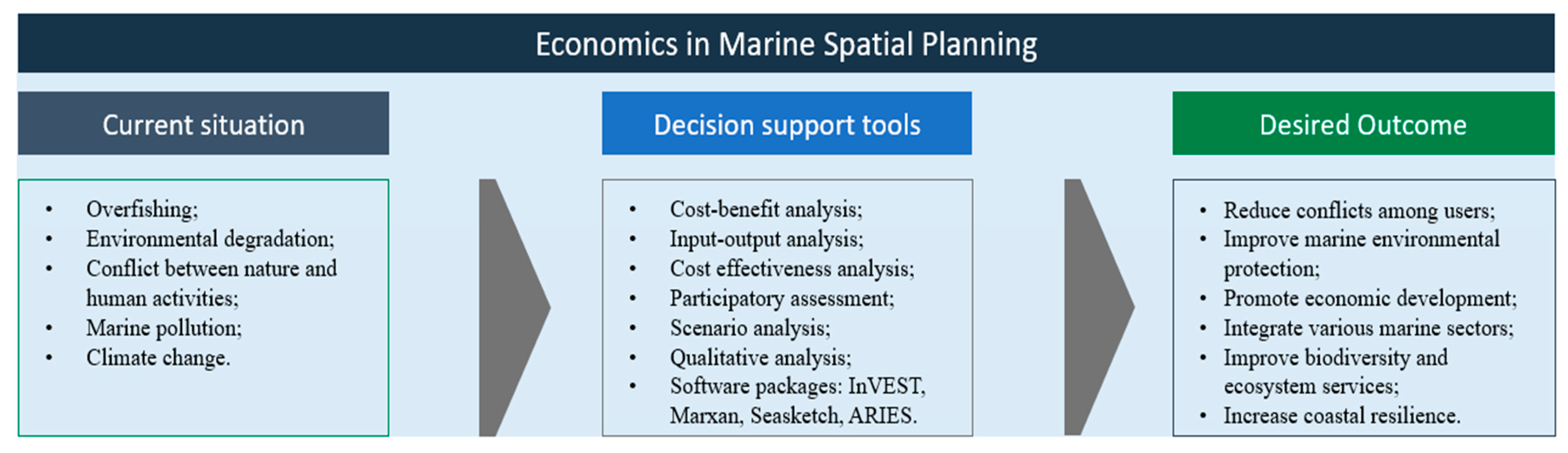
Table 4.
Examples of social and economic aspects considered in beckMSP.
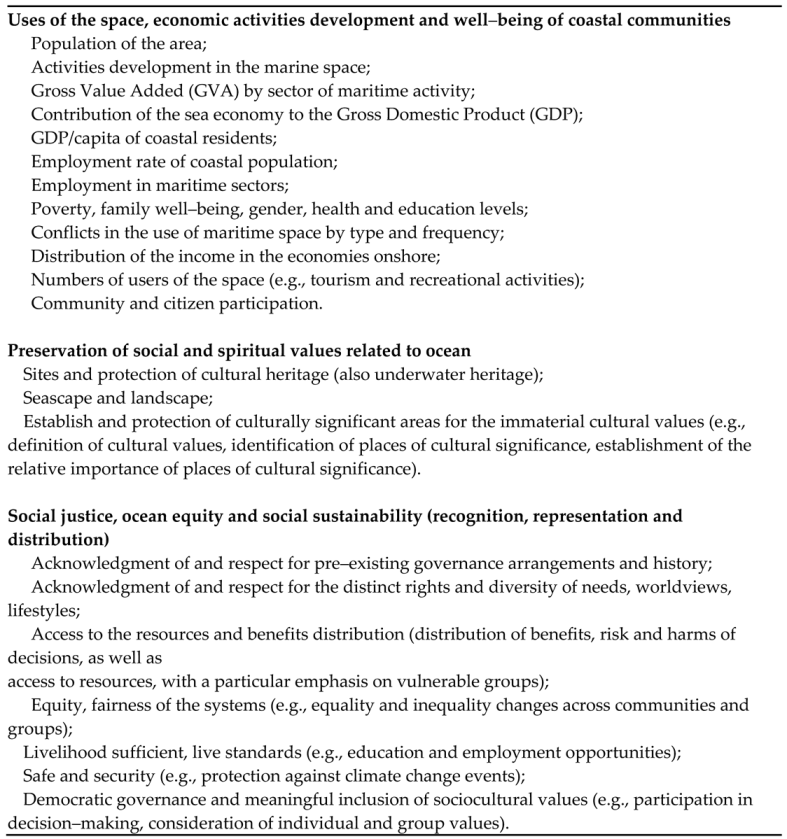
Source: Elaborated by authors based on the case studies of section 3, especially in Gee et al. (2017) Ferreira et al. (2018), Saunders et al. (2020), Frederiksen et al. (2021) and Nursey–Bray et al. (2021).
Disclaimer/Publisher’s Note: The statements, opinions and data contained in all publications are solely those of the individual author(s) and contributor(s) and not of MDPI and/or the editor(s). MDPI and/or the editor(s) disclaim responsibility for any injury to people or property resulting from any ideas, methods, instructions or products referred to in the content. |
© 2023 by the authors. Licensee MDPI, Basel, Switzerland. This article is an open access article distributed under the terms and conditions of the Creative Commons Attribution (CC BY) license (http://creativecommons.org/licenses/by/4.0/).
Copyright: This open access article is published under a Creative Commons CC BY 4.0 license, which permit the free download, distribution, and reuse, provided that the author and preprint are cited in any reuse.


