
Submitted:
28 November 2023
Posted:
30 November 2023
You are already at the latest version
Abstract
Geotechnology techniques were used to specialize the occurrences of the species, based on forest inventories and information available in open-access databases, as well as data from herbaria with catalogs available online, and bibliographical references indicating places of occurrence in the Amazon. GIS-integrated Weighted Mean Ordination (WMO) was chosen as the technique for evaluating the topoclimatic index. Thirteen topoclimatic variables were used, applying principal component analysis techniques such as multidimensional preference to compare the participation of each variable in the two components; Biplot to identify the relationships between the variables and cluster to identify the average distance between proximal classes. The interpolated surfaces of the specialized climatic variables were separated into frequency bands that helped calculate the probability of occurrence, from which a scale of 0 to 10 was established, indicating lower and higher probabilities. Three potential zones were identified, classified as high, medium and low, where areas with high potential occupied 32% of the territory of Pará, medium areas 36% and 32% with low potential for cultivation and presence. The intermediate class had the highest percentage, totaling 36% of the state, explained by the average ratio between the weights adopted.
Keywords:
andiroba
; natural resources
; topoclima
1. Introduction
The Amazon biome has a plant diversity that is associated with specific environmental conditions. From a climatic point of view, the high water supply at one time of the year favors and the reduction at another, causing surpluses and/or deficits that condition the floristic pattern, explaining the adaptation of species to the region's thermal-hydric regime. However, this exuberant forest is highly fragile in the face of climatic extremes [1], requiring research to understand the dynamics of species distribution in order to support strategic planning to conserve forest species [2]. The andiroba (Carapa Guianensis Aubl) is one of these species native to the Amazon that can reach around 50 m in height, has whitish flowers with a pleasant aroma [3] and receives different vernacular names in the state of Pará (andiroba, andiroba-branca, andiroba-cedro, andiroba-doigapó, andiroba-saruda; andiroba-vermelha, andirobeira, andirobinha, andirova, carapa, jandiroba and penaíba), according to [4]. It is worth noting that according to [5], the name andiroba comes from the Tupi yandy (oil), and rob (bitter), referring to the taste of the oil extracted from the fruit [6,7]. observed precocious individuals in forest plantations that started fruiting at 4 years of age, but full fruiting only occurred between 7 and 10 years. The species is the third most used non-timber product in the Marumú and Arapiuns rivers in western Pará, an area that is home to several communities and covers around 1.3 million hectares [8].
This fact is relevant, as it also gives rise to cooperation between institutions that can contribute to actions for sustainable use and adding value to the product, reflecting an increase in the quality of life of rural populations who live from extractives associated with the value chain of this species in the state. In terms of use, [8] pointed out that the genus Carapa (Meliaceae) has been used in the treatment and prevention of cutaneous and mucocutaneous leishmaniasis in native Amazonian communities. The oil is also widely used to treat sore throats and colds in the form of a syrup that includes other medicinal plants, as well as for healing wounds, skin lesions, swellings and bruises [9].
The Species respond to topoclimatic conditions, as exemplified by [10] when analyzing topoclimatic responses for the Tachigali vulgaris species. According to [11], the state of Pará has an average rainfall variability of around 2,000 mm, ranging from 1,600 mm to 1,900 mm, and the average annual air temperature is between 24 and 26ºC, with air humidity of approximately 80%. The Andirobeira occurs in regions with a humid tropical climate, with annual rainfall between 1,800 mm and 3,500 mm.
By analyzing interactions climate, in the soil-plant-atmosphere system, plays an important role in the biogeography of species [12]. Computational advances and the availability of geospatial tools have contributed greatly to these assessments, allowing for complex and feasible analyses [13]. In this way, the effects of topoclimatic gradients can be used in various applications, helping to analyze the distribution of species and climatic variations [14,15], which help to indicate potential areas for decision-making in silvicultural responses, to support the inclusion of species in productive silvicultural arrangements [10], among others. The delimitation of these areas aims to support planning in homogeneous plantations, as well as in integrated systems such as agroforestry (SAFs), strengthening the regional bioeconomy by including andiroba plantations in the production process [15].
The objective of this study was to evaluate potential topoclimatic zones for Carapa Guianensis Aubl (Andiroba) in order to subsidize production strategies for crops in the state of Pará.
2. Material and Methods
2.1. Study Area
The study area refers to the state of Pará, which is located in the eastern portion of the Brazilian Amazon, between latitudes 2°30'N and 9°30'S and longitudes 46°00'W and 59°00'W, totaling 1,247,690 km². Based on the Köppen typology, adapted by [10], the climatic conditions fall into typology a when analyzing the average annual temperature, which is above 18°C, and with eight subtypes according to the total annual rainfall and the amount of water precipitated in the least rainy month. Thus, eight climatic subtypes are identified in Pará (Af2 and Af3; Am1, Am2, Am3 and Am4; Aw3 and Aw4), according to [16]. Pará, which is one of the nine states that make up the Amazon region and has a rich hydrographic network, drained mainly by the Amazon, Pará, Tapajos, Tocantins, Xingu rivers and their tributaries [17] with high Phyto ecological diversity, predominant under conditions typical of the Amazon Biome, with the greatest biodiversity in Brazil [18].
2.2. Bibliometrics
In order to evaluate the results of research on the subject of this work, we selected three search words on the Web of Science platform, considering the identification of the largest number of publications considered together (C. Guianensis, topoclimate zone and Amazon). The bibliometric analyses were carried out according to the methodology described by [19]. The search results were saved in format and analyzed in the R program using the script library ("bibliometrix"). The data was analyzed and presented using only the new word count and the Sanky diagram to show the three dimensions most cited authors, countries with the most publications and most cited words in the abstracts of the articles analyzed between 2008 and 2023.
2.3. Organization of the Database
The Pointers of occurrences of Carapa Guianensis Aubl were obtained from open-access databases contained in herbaria (Museu Emilio Goeldi Paraense - MPEG, Embrapa Amazônia Oriental - CPATU and Instituto Nacional de Pes-quisa na Amazônia - INPA), based on access to catalogs available online. We also collected data from bibliographical references on the occurrence of the species. It was first necessary to investigate the distribution of the species in the Amazon, basically analyzing abiotic data to compose the matrices for the multivariate analyses. Data on biotic variables was acquired by compiling information from different sources. The data collected was obtained and organized according to Brazil's official geographic coordinate system, SIRGAS 2000, in order to standardize it for subsequent analyses.
The information was basically obtained from the RADAMBRAZIL Project, made available by the Reference Center for Environmental Information (CRIA), using species Link, the Global Biodiversity Information Facility (GBIF), the New York Botanical Garden and the Missouri Botanical Garden to validate points in the high, medium and low potential zones. The database was organized for the Legal Amazon, with the state of Pará being included in this study. Topoclimatic assessment is a zoning-oriented technique based on the occurrence of the species. The plant's response to environmental conditions, the place where the processes of exchange, transfer and conversion of matter and energy occur through interactions in the soil-plant-atmosphere system, according to [20].
The analysis of climate data used two existing formats for representing information in geographical space: vector data provided by the National Institute of Meteorology (INMET) and the National Water Agency (ANA). The vector data is based on historical series from INMET, corresponding to an analysis period of 30 years that correspond to the climatological normals (1981-2021), available with a 95% confidence interval and standard error ±1.96. The matrix data was obtained from the Worldclim platform where it is possible to obtain estimated and interpolated surface information, as described by [21].
2.4. Selection of Variables for Topoclimatic Zoning
The climate variables selected were air temperature (maximum, average and minimum), rainfall and air humidity. Derived variables such as the wettest and least rainy quarters, total annual rainfall, water balance, vapor pressure deficit and air humidity were analyzed. The topographic data was obtained from the Global Elevation Model (GMTED2010 - Global Multi-resolution Terrain Elevation Data 2010), made available with a spatial resolution of 30 arc seconds by the North American Space Agency (NASA).
The criteria used for this study are related to the environmental factor and restricted to possible areas of occurrence. Thus, a set of environmental variables considered decisive for the establishment of the species was defined, following the methodological assumptions of [20] to identify the potential zones of native species in the Amazon [7].
Annual precipitation (mm): The average annual precipitation reveals the rainfall totals offered by the atmosphere throughout the year, which vary in the species' distribution area in the state of Pará.
- a)
- Maximum air temperature (°C): High temperatures influence the physiological processes of plants, seed germination and root activity [22]. This variable is of fundamental importance when planning forest plantations, as it is capable of causing changes in highly sensitive ecological processes. Furthermore, statistically significant warming trends have been observed in the Amazon region since 1970 [23].
- b)
- Average air temperature (°C): Temperature averages reveal the thermal patterns recorded, as well as anomalies that can be positive or negative in average conditions in the study area.
- c)
- Minimum air temperature (°C): This is a meteorological variable that, together with the maximum temperature, makes it possible to assess the temperature range of a location or the thermal tolerance of a species. The taxi-branco is a species sensitive to minimum temperature, showing greater increases in height in areas with high temperatures [24], so this variable is considered a limiting factor for planting the species and is necessary for inclusion in zoning.
- d)
- Air humidity (°C): Relative humidity indices can interfere with the choice of areas of interest for planting a particular species, explained by topoclimatic factors (exposure to the sun's rays, wind, terrain conformity and temperature), as well as the type of vegetation cover, where air humidity can favor the presence of pathogens [25].
- e)
- Elevation: By including this variable, the effect of topography on the ability of each forest species to express their genetic potential is taken into account, as it influences plant metabolism. The lowest altitudes have the highest temperatures, which require high evapotranspiration rates and, consequently, the highest vapor pressure deficits.
2.5. Multiple Regression
To develop the zoning map and identify potential areas for planting and the occurrence of andiroba, different input variables were used, organized in a geographic database system. For the regression analysis and other statistical calculations, the statistical program Statistical Analysis System - SAS was used and the variable selection analysis was applied using the backward method, which consists of obtaining a model, where you start with the equation in which all the variables are included, and these are eliminated one at a time at each step from a pre-established level of significance [26].
Multiple Regression (MR) as a set of statistical techniques that make it possible to assess the relationship between a dependent variable and several independent variables. In this case, the potential zone for the andiroba species represents the dependent variable, while the explanatory factors are represented by the topoclimatic variables.
Fourteen input variables were used in the model: 1) relative humidity; 2) altitude; 3) vapor pressure deficit (VPD); 4) annual rainfall; 5) total rainfall in months less than 100 mm; 6) total rainfall in months less than 60 mm; 7) least rainy quarter; 8) climatological maximum temperature; 9) annual average air temperature; 10) climatological minimum temperature; 11) climate typology; 12) Water deficiency (CAD = 300mm); 13) latitude and 14) longitude. The model selected, after applying the statistical analysis, contains nine explanatory variables that indicate the zones according to their potential, according to the equation generated by the backward method:
The occurrence points of Carapa Guianensis Aubl were located using information available in open-access databases, such as data from herbaria (Museum Emilio Goeldi Paraense - MPEG, Embrapa Amazonian Oriental - CPATU and National Institute for Amazonian Research - INPA), accessing the catalogs available online, as well as using data obtained from the literature indicating the species' places of occurrence. It was first necessary to investigate the distribution of the species in the Amazon, basically analyzing abiotic data to compose the matrices for the multivariate analyses. Data on biotic variables was acquired by compiling information from different sources. The data collected was obtained and organized according to Brazil's official geographic coordinate system, SIRGAS 2000, in order to standardize it for subsequent analyses.
The information was basically obtained from the RADAMBRAZIL Project, made available by the Reference Center for Environmental Information (CRIA), using species Link, the Global Biodiversity Information Facility (GBIF), the New York Botanical Garden and the Missouri Botanical Garden to validate points in the high, medium and low potential zones. The bases were georeferenced for the Legal Amazon, with the state of Pará being included in this study. Topoclimatic assessment is a zoning technique based on the occurrence of the species, i.e., the plant's response to environmental conditions, the place where the processes of exchange, transfer and conversion of matter and energy occur through interactions in the soil-plant-atmosphere system, according to [21].
The analysis of climate data used two existing formats for representing information in geographical space: vector data provided by the National Meteorological Institute (INMET) and the National Water Agency (ANA). The vector data is based on historical series from INMET, corresponding to an analysis period of 30 years that correspond to the climatological normals (1981-2021), available with a 95% confidence interval and standard error ±1.96. The matrix data was obtained from the Worldclim platform where it is possible to obtain estimated and interpolated surface information, as described by [10].
The climate variables selected were air temperature (maximum, average and minimum), rainfall and air humidity, and derived variables such as the wettest and least rainy quarters, total annual rainfall, water balance, vapor pressure deficit and air humidity were analyzed. The topographic data was obtained from the Global Elevation Model (GMTED2010 - Global Multi-resolution Terrain Elevation Data 2010), made available with a spatial resolution of 30 arc seconds by the North American Space Agency (NASA).
The data was organized by class, based on the histogram of distribution of this variable for subsequent preparation of the slope map of the Amazon territory, for integrated evaluation between the response variables analyzed for the preparation of the topoclimatic zoning of Carapa Guianensis Aubl for the state of Pará.
3. Results
Analyzing the Figure 1, it is possible to see that 10 of the most cited authors included C. guianensis seed, production, the same species studied in this study, climate, dbh, distribution, trees, models and forest in their keywords. The four countries with the most papers were Brazil, Switerland, USA and United Kingdon.
Looking at the word cloud represented in Figure 2 reinforces the fact that C. guianensis is a typical species of tropical rainforest in the Amazon. The effects of climate are also evident, as the cloud shows fruit production, El Niño and the ecosystem services provided by this species native to the region.
A totally of 524 natural occurrences of the species Carapa Guianensis Aubl were recorded in the state of Pará. The geographical distribution of andiroba was divided into three groups, with 4 points taken from the RADAMBRAZIL Project, 200 points from the Global Biodiversity Information System (GBIF) and 320 points from herbaria, indicating the areas of concentration (Figure 3). Considering the micro-regions with the highest concentration of Carapa Guianensis Aubl, it can be seen that its presence is greater in dense ombrophilous forest, floodplain forest and other phytophysiognomies, such as open ombrophilous forest and deciduous seasonal forest.
Based on the results presented, Figure 4 shows the frequency and concentration of Carapa Guianensis Aubl in the state of Pará, which is conditioned by its adaptation to specific environments. Therefore, when planning conservation and sustainable management strategies, it is recommended to observe the geographical distribution of the species. The dominance of the species' occurrence is close to the drainage network, reinforcing the species' adaptive capacity to varzea and land firmed environments, but where there is a high water supply. The localities represented on the map reinforce the importance of using herbarium records to expand the information obtained on native Amazonian species in research projects in the region. The results confirm the predominance in environments where the average annual rainfall is around 2,500 mm. It is also worth noting that the concentration of C. guianensis Aubl is associated with other abiotic variables not considered in this study.
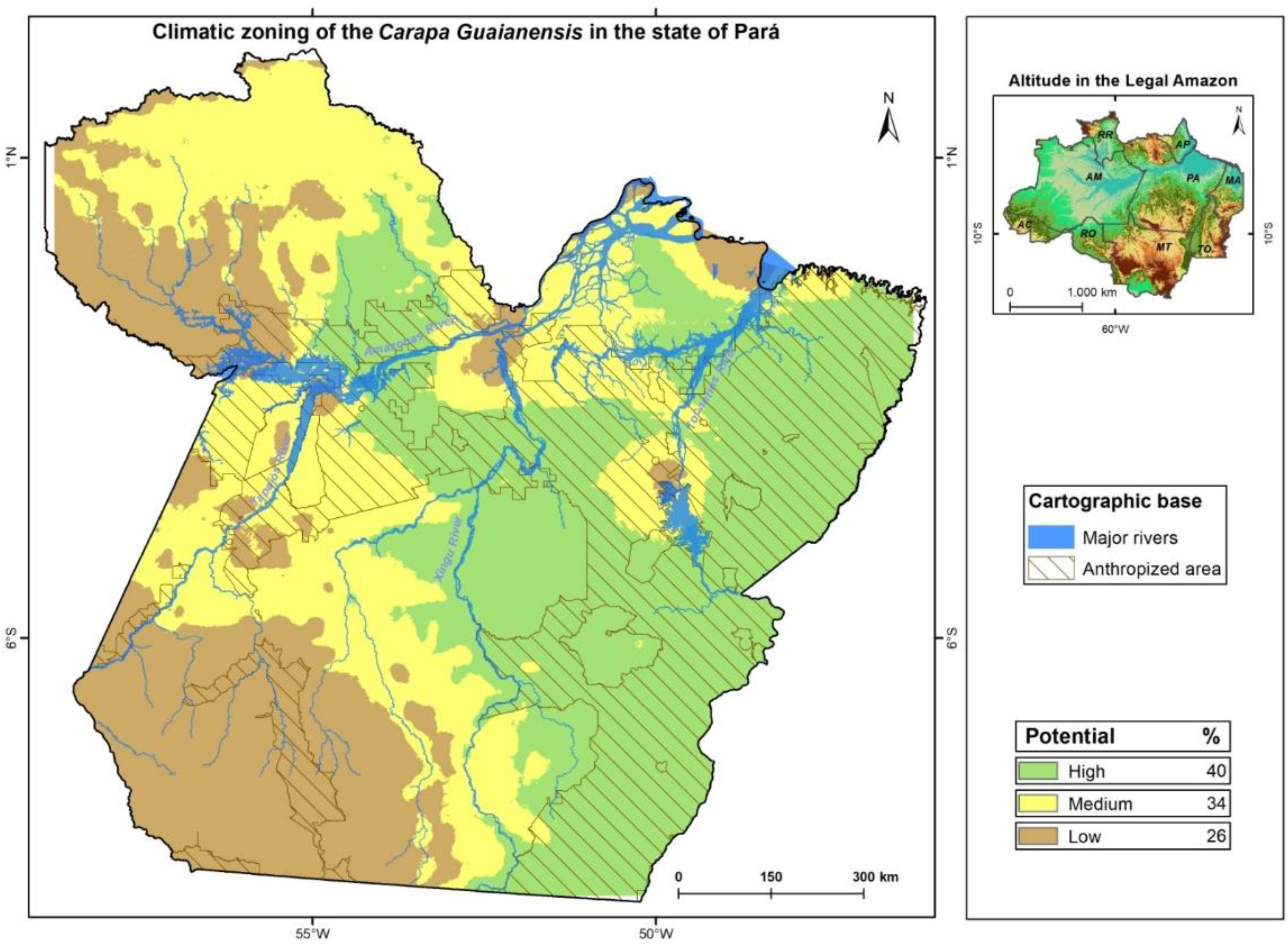
The mapping of potential areas for cultivation and natural location of Andiroba identified three zones of high, medium and low potential, with the high potential areas corresponding to 32% of the territory of the state of Pará, and 32% with low potential for cultivation and presence. The intermediate class had the highest percentage of 36% of the state, due to the average relationship between the weights adopted in this study.
In the generation, development and maintenance of technology-based businesses using natural inputs such as andiroba, we can see that studies that represent the location, as well as the characteristics of the development of the species, are a fundamental factor, since it is mainly through information that organizations can differentiate themselves and remain competitive in the extraction of by-products.
The innovation process requires the application of new knowledge, resulting in new products, processes or services that increase the complexity of the operational process and make flexibility a fundamental requirement for it and its management [26].
An important characteristic of andiroba oil is its similarity to oils traditionally used as additives in lubricants and metal cutting oils. This makes it potentially substitutable for mineral oils, vegetable oils or animal fats [22]. The use of andiroba oil as a biodiesel or lubricant has been proven by [25]. Due to the recognized uses of andiroba, this species has generated interest in intellectual protection on the part of researchers, companies and universities, revealing the growing interest in registering patents.
The wood is exported for use in fine wood products, as it belongs to the same family as mahogany and can even be called "mahogany" [27]. In addition to being used as an antipyretic, vermifuge and cicatrizing, the bark tea is also used as an insect repellent and in the manufacture of candles, soap and shampoo [28]. Andiroba seed oil is a raw material for phytosanitary and cosmetic products and is exported from Brazil to more than 50 international destinations [16].
4. Conclusion
From the results shown, it can be deduced that the use of geoprocessing techniques and statistical analysis is a favorable strategy for identifying areas with high potential for the presence and cultivation of Andiroba. The methodology used made it possible to aid decision-making regarding the selection of areas for cultivation and possible occurrence in their appropriate topoclimatic classification, considering bioclimatic factors, climate typology, slope, rainfall, so that they are favorable for its development.
Authors' Contribution
The authors effectively participated in the preparation of the manuscript from the initial work conception to the conclusion, as described below, referring to the specificities in each stage: 1 -Denison Lima Correa worked on the organization of the database and on the density analyzes to extract the results of the areas with the highest records of occurrences of the species of interest in this work, analysis, and discussion of the results for finalizing the manuscript and submission. 2 -Lucieta Guerreiro Martorano, participated from the conception of the theme of the work, analysis of climatic variables, analysis and discussion of the results and follow-up in the different phases of the work until the conclusion and submission of the manuscript. 3 -Leila Sheila Silva Lisboa worked on the evaluation of the geodatabase and on the elaboration of the final maps and discussion of the results. 4 -Carlos Tadeu Dos Santos Dias, participated from the conception of the theme of the work, analysis statistics, and discussion of the results. 5 -Alberdan Silva Santos, participated from the conception of the theme of the work, analysis statistics, and discussion of the results. 6 -Rosa Helena Veras Mourão, participated from the conception of the theme of the work, analysis, and discussion of the results.
Acknowledgements
The authors would like to express their gratitude to the Coordination for the Improvement of Higher Education Personnel (CAPES) for awarding a research grant to the first author, as it has been fundamental for the Bionorte Doctoral Program (PDPG-UFOPA) Consolidation of Postgraduate Studies in Health Sciences with a focus on Biotechnology and Therapeutic Innovation.
References
- Lima, R. M. B. de. Crescimento do Sclerolobium paniculatum Vogel na Amazônia, em função de fatores de clima e solo. Ph.D Tese, Universidade Federal do Paraná, Curitiba, Brasil, 2004.
- Ciemer, C.; Boers, N.; Hirota, M.; Kurths, J.; Müller-Hansen, F.; Oliveira, R. S.; Winkelmann, R. Higher resilience to climatic disturbances in tropical vegetation exposed to more variable rainfall. Nat. Geosci., 2019, 12, 174–179. [CrossRef]
- Odonne G.; Valadeau C.; Alban-Castillo J.; Stien D.; Sauvain M.; Bourdy G. Medicalethnobotany of the Chayahuita of the Paranapura basin (Peruvian Amazon). Journal of Ethnopharmacology, 2013, 146(1),127–153. [CrossRef]
- Carvalho, P. R. C. Andiroba: Carapa guianensis. In Carvalho, P. R. C. Espécies arbóreas brasileiras. Brasília: Embrapa Informação Tecnológica; Colombo: Embrapa Florestas, 2014, 5, 87-97.
- Braga, R. Plantas do Nordeste, especialmente do Ceará. 2. ed. Natal: Ed. Universitária da UFRN, 1960. 540 p. (Coleção mossoroense, 315).
- Martorano, L. G.; Vitorino, M. I.; Silva, B. P. P. C.; Moraes, J. R. da S. C.; Lisboa, L. S.; Sotta, E. D.; Reichardt, K. Climate conditions in the eastern amazon: rainfall variability in Belem and indicative of soil water deficit, African. Journal Agricultural Research, 2017, 12, 1801-10. [CrossRef]
- Chia, C. Y.; Medeiros, A. D.; Corraes, A. D. M. S.; Manso, J. E. F.; Silva; C. S. C. D.; Takiya, C. M.; Vanz, R. L. Healing effect of andiroba-based emulsion in cutaneous wound healing via modulation of inflammation and transforming growth factor beta 3. Acta Cirúrgica Brasileira, 2018, 33, 1000-1015. [CrossRef]
- Gama, J. R. V.; Santos, S. R. M. Utilização de recursos florestais no Conjunto de Glebas Mamuru-Arapiuns. In: Tourinho, M. M; Gama, J. R. V; Palha, M. D. C; Santos, S. R. M; Mattar, P.N. (Org.). Mamuru-Arapiuns: uma região amazônica em disputa. Belém: UFRA, 2014. p. 124-155.
- Coelho, A. A. et al. Andiroba: usos e extração de óleo em área de assentamento no oeste paraense. Terceira Margem Amazônia, 2018, 3(11).
- Maia, P. C. C.; Vasconcellos Sobrinho, M.; Mendes, R. L. R. Governança da água na Amazônia Paraense. P2P e Inovação, 2022, 9(1), 8–28. DOI. [CrossRef]
- Ferreira Filho, D.; Lira, B.; Crispim, D.; Pessoa, F.; Fernandes, L. Análise pluviométrica no estado do Pará: comparação entre dados obtidos de estações pluviométricas e do satélite GPCC. Revista Brasileira de Climatologia, 2020, 26. [CrossRef]
- Gkaraveli, A.; Good, J. E. G.;Williams, J. H. Determining priority areas for native woodland expansion and restoration in Snowdonia National Parks, Wales. Biological Conservation, 2004, 115(3), 395-402. [CrossRef]
- Santibãnez, F.; Morales, L.; La Fuente, J. De; Cellier, P.; Huete, A. Topoclimatic Modeling for minimum temperature prediction at a regional scale in the Central Valley of Chile. Agronomie, 1997, 17(6/7), 307-314. [CrossRef]
- Ashcroft, M. B.; Cavanagh, M.; Eldridge, M. D. B.; Gollan, J. R. Testing the ability of topoclimatic grids of extreme temperatures to explain the distribution of the endangered brush-tailed rock-wallaby (Petrogale penicillata). Journal of Biogeography, 2014, 41(7). [CrossRef]
- Oliveira, I. dos S. da S.; Tellis, C. J. M.; Chagas, M. do S. dos S.; Behrens, M. D.; Calabrese, K. da S.; Silva, A. L. A.; Souza, F. A. Óleo de Semente de Carapa guianensis Aublet (Andiroba): Composição Química e Atividade Antileishmania de Frações Ricas em Limonóides. BioMed Research Internacional, 2018, 1-10.
- Enriquez, G. Amazônia–Rede de inovação de dermocosméticos: Sub-rede de dermocosméticos na Amazônia a partir do uso sustentável de sua biodiversidade com enfoques para as cadeias produtivas da castanha-do-pará e dos óleos de andiroba e copaíba. Parcerias Estratégicas, 2009, 14(28), 51-118.
- Leite, F. F.; Pacheco, M.; Morón-Villarreyes, J. A. Óleo de andiroba (Carapa Guianensis Aubl Comunicação pessoal; Trabalho realizado em conjunto com a MIRACEMANUODEX S.A.; São Paulo, 3p. 1993.
- Almeida, A. S.; Lameira, W. J. De M.; Pereira, J. G.; Thalês, M. C.; Sales, G. M. Potencial de pressão antrópica na região Nordeste Paraense, Brasil. Ciência Florestal, 2022, 32(1), 01–18. [CrossRef]
- Aria, M.; Cuccurullo, C. Bibliometrix: An R-tool for comprehensive science mapping analysis. Journal of Informetrics, 2017, 11(4), 959-975. [CrossRef]
- Martorano, L. G.; Monteiro, D. C. A.; Brienza Junior, S.; Lisboa, L. S.; Espírito Santo, J. M.; Almeida, R. F. Top-bioclimate conditions associated to natural occurrence of two Amazonian native tree species for sustainable reforestation in the State of Para, Brazil. In Villacampa, Y; Brebbia, C. A. Ecosystems And Sustainable Development, 2011, 144, 111-122.
- Martorano, L. G. et al. Zoneamento topoclimático do taxi-branco (Tachigali vulgaris L.F.) na Amazônia Legal: estratégias de planejamento com metas de desenvolvimento sustentável— Belém, PA. Embrapa Amazônia Oriental, 2018.
- Larcher, W. Ecofisiologia vegetal. São Carlos: RiMaArtes e Textos, 2004. 531p.
- Victoria, R. L.; Martinelli, L. A.; Moraes, J. M.; Ballester, M. V.; Krusche, A. V. Surface air temperature variations in the amazon region and its borders during this century. Journal of Climate, 1998, 11(5), 1105-1110. [CrossRef]
- Lima, R. M. B. de. Crescimento do Sclerolobium paniculatum Vogel na Amazônia, em função de fatores de clima e solo. Ph.D Tese, Universidade Federal do Paraná, Curitiba, Brasil, 2004.
- Pereira, A. R.; Angelocci, L. R.; Sentelhas, P. C. Agrometeorologia: fundamentos e aplicações práticas. Guiabá: Agropecuária, 2002.
- Ribon, A. A. et al. Seleção de método estatístico para modelos de estimativa da. Revista de Agricultura, 2014, 89(1), 29-40.
- Silva, C. L. M. et al. Obtenção de ésteres etílicos a partir da transesterificação do óleo de andiroba com etanol. Dissertação (Mestrado),Universidade Estadual de Campinas, Campinas, São Paulo, Brasil, 2005.
- Embrapa Amazônia Oriental. Espécies arbóreas da Amazônia, Carapa guianensis, Andiroba - Características Gerais da Espécie Carapa guianensis, 2004.
Figure 1.
Sankey diagram showing the authors, the most cited words in the abstract and the first author's country of origin.
Figure 1.
Sankey diagram showing the authors, the most cited words in the abstract and the first author's country of origin.
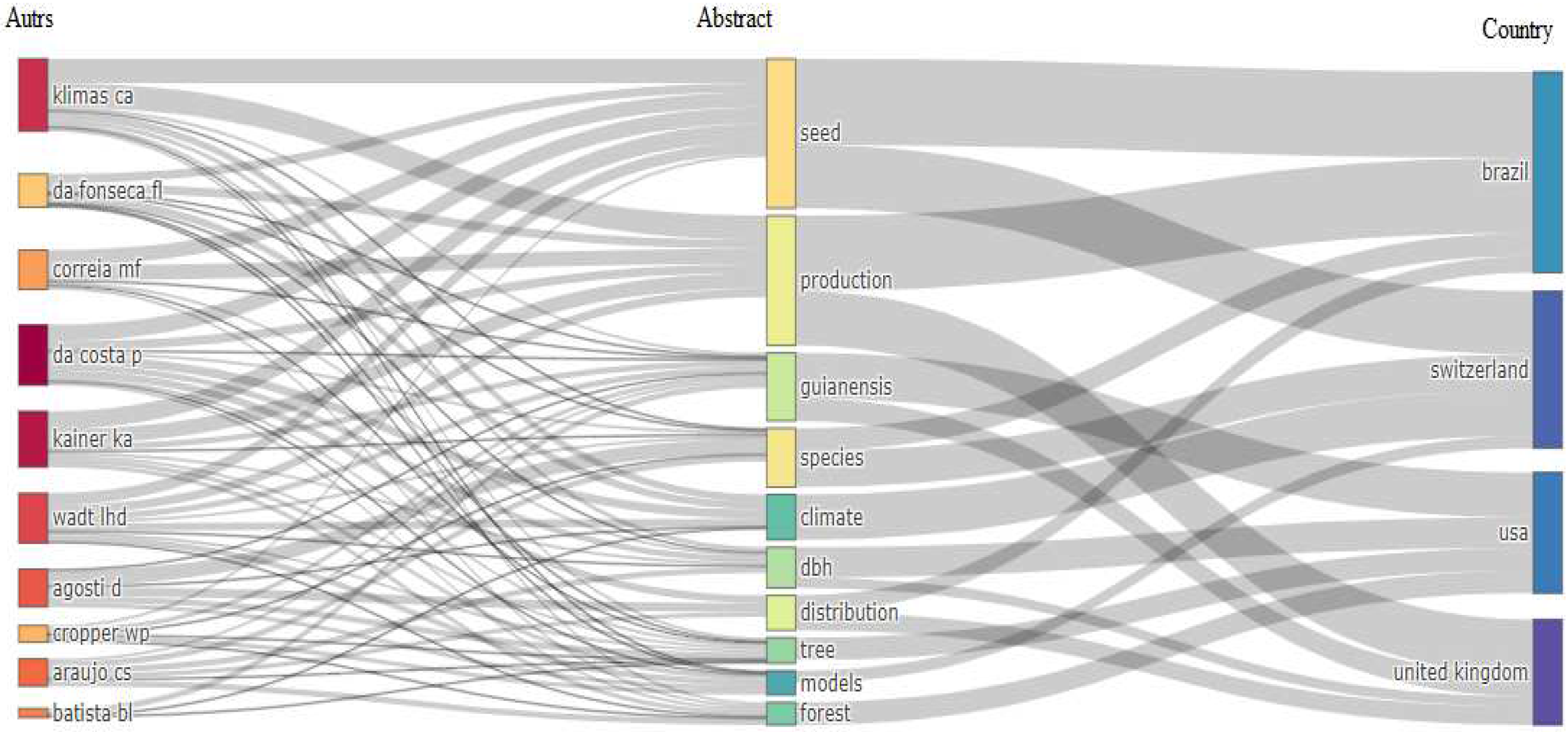
Figure 2.
Cloud of the most cited words in articles on the subject on the Web of Science.
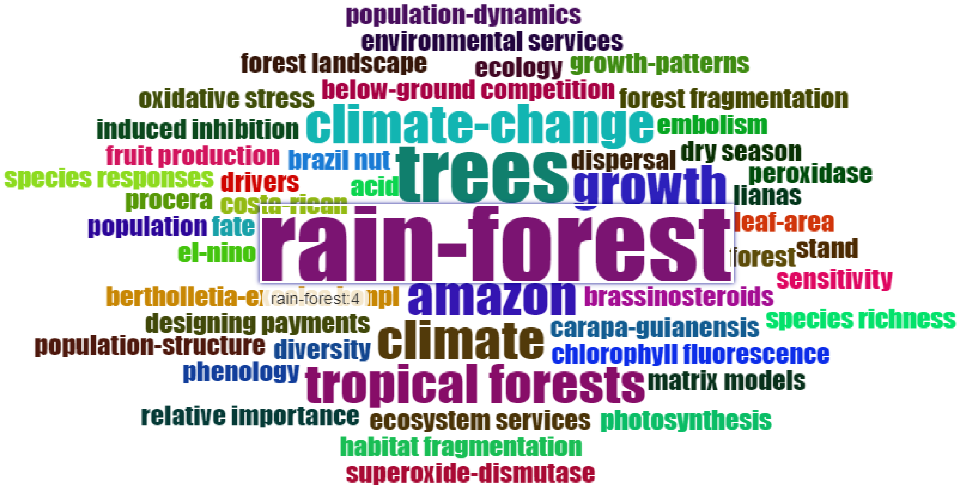
Figure 3.
Locations with the highest occurrences of Carapa Guianensis Aubl in the state of Pará.
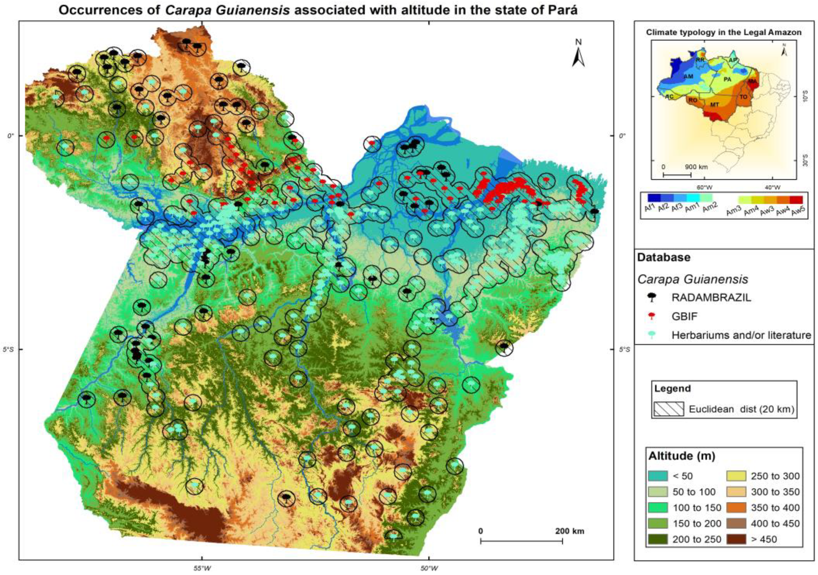
Figure 4.
Topoclimatic zoning of Carapa Guianensis Aubl in the state of Pará.
Disclaimer/Publisher’s Note: The statements, opinions and data contained in all publications are solely those of the individual author(s) and contributor(s) and not of MDPI and/or the editor(s). MDPI and/or the editor(s) disclaim responsibility for any injury to people or property resulting from any ideas, methods, instructions or products referred to in the content. |
© 2023 by the authors. Licensee MDPI, Basel, Switzerland. This article is an open access article distributed under the terms and conditions of the Creative Commons Attribution (CC BY) license (http://creativecommons.org/licenses/by/4.0/).
Copyright: This open access article is published under a Creative Commons CC BY 4.0 license, which permit the free download, distribution, and reuse, provided that the author and preprint are cited in any reuse.


