Preprint
Article

Location Planning of Emergency Medical Facilities using the p-Dispersed-Median Modeling Approach

Altmetrics

Downloads

111

Views

42

Comments

0

A peer-reviewed article of this preprint also exists.

This version is not peer-reviewed

Submitted:

03 November 2023

Posted:

03 November 2023

You are already at the latest version

Alerts
Abstract
This research employs a spatial optimization approach customized for addressing equitable emergency medical facility location problems, through the p-dispersed-median problem (p-DIME). The p-DIME integrates two conflicting classes of spatial optimization problems, dispersion, and median problems, aiming to identify the optimal locations for emergency medical facilities to achieve a balanced spatial distribution of emergency medical services (EMS) while effectively serving demands. To demonstrate the utility of the p-DIME model, we selected Gyeongsangbuk-do in South Korea, recognized as one of the most challenging areas for providing EMS to the elderly population (aged 65 and over). This challenge arises from the significant spatial disparity in the distribution of emergency medical facilities. The results of the model assessment gauge the spatial disparity of EMS, provide significantly enhanced solutions for a more equitable EMS distribution in terms of service coverage, and offer policy implications for future EMS location planning. In addition, to address the computational challenges posed by p-DIME's inherent complexity, involving mixed-integer programming, this study introduces a solution technique through constraint formulations aimed at tightening the lower bounds of the problem's solution space. The computational results confirm the effectiveness of this approach in ensuring reliable computational performance, with significant reductions in solution times, while still producing optimal solutions.
Keywords: 
Subject: Public Health and Healthcare  -   Health Policy and Services

1. Introduction

Emergency medical care is a first-line critical infrastructure intended to ensure the quality of life for citizens facing various serious medical situations. The emergency healthcare system has garnered significant attention over the past few decades due to the continuing growth of the aging population and rapid urbanization, resulting in spatial disparities between rural and urban areas [1,2]. In particular, the population of older adults is subject to life-threatening disease-related emergencies, such as cardiac arrest and diabetic shock, while emergencies affecting members of younger generations are more pronounced by violence and drug abuse, along with accident-related trauma inflicted in severe car crashes [3]. Thus, locations for emergency medical facilities should be established to ensure easy access to emergency care for a variety of urgent medical incidents.
With the requirements of the emergency medical services (EMS), dispersing the emergency medical facilities in a region is a natural consideration to achieve spatial equity of medical facilities, serving potential demands as much as possible within the service area [4]. This principle holds true, especially for time-sensitive critical services such as trauma centers, as the EMS represents the primary tier of the emergency services, and the travel time becomes a crucial factor in handling life-threatening conditions for cases in rural or underserved areas.
Many countries have sought to circumvent the rapid increase in demand for EMS by developing their own EMS systems that align with their citizens’ needs, according to their economic capabilities and types of medical service, supply of medical personnel or labor, and even political systems for operation. In the case of South Korea, the government has invested over USD 200 million since 2010 to establish a hierarchical system of emergency medical facilities under the nation’s Emergency Medical Service Act, with three geographic levels: (1) Regional Emergency Medical Centers (tertiary), (2) Local Emergency Medical Centers (secondary), and (3) Local Emergency Medical Institutions (hereafter LEMIs; primary level) [1]. Of particular concern is focused on the location of the LEMIs as they are the first-line emergency facilities nationwide, designed to serve all areas in demand of the national emergency medical system.
The primary goal of the LEMIs is to promote equitable access to medical services by strategically distributing them across regions, particularly within a province (referred to as ‘do’ in South Korea). This approach aims to operate the EMS system effectively cover the demands of the community by LEMIs within budget constraints. As part of these efforts, the government periodically (every 3 years) selects LEMIs from a pool of candidate medical institutions, and provides financial support to ensure the delivery of critical pre-hospital emergency medical services to patients at the local community level. Despite these efforts, however, the current placement of the facilities is disproportionately arranged due to various factors [5,6], which raises concerns of geographic disparities in healthcare service access [7,8]. Specifically, certain provinces in South Korea face challenges in providing coverage to people living in remote areas such as rural or suburban areas, through the LEMIs [9,10,11]. This spatial inequity becomes more pronounced as the aging population tends to reside in these areas to escape financially stressful living environments after retirement. Therefore, mitigating spatial inequality is not only a crucial issue for the overall healthcare service of individuals in a region but also for the quality of the national EMS system.
According to the South Korean National Geographic Information Institute [12], the study area, Gyeongsangbuk-do is identified as the most challenging province in terms of providing emergency healthcare service coverage to the population of older adults (+65) due to the significant spatial disparity in the distribution of LEMIs. In this province, only 69.15% of the population resides within 10km (~30 minutes of travel time) from any emergency medical center, including LEMIs. This represents the lowest ratio among the nine provinces of the country, with an overall mean of 73.26%. Given this context, this area furnishes a good study area for exploring effective planning scenarios for optimizing the placement of LEMIs. There are sizeable body of research regarding the assessing the distribution of EMS facilities in the context of South Korea [10]. However, a majority of them focused on assessing EMS coverage to identify underserved areas of medical services. In a methodological perspective, the models they employed were network-based indicators, such as accessibility measures with descriptive statistics. The policy implications in their conclusions thereby did not explicitly address substantial solutions for resolving the disparity issues in healthcare access from a planning perspective.
In the context of spatial planning to address medical facility location problems, a spatial optimization approach has been employed to determine the optimal arrangement of medical facilities. This approach considers factors such as demand accessibility and resource availability [13]. In the context of the EMS system, common approaches include the strategic distribution of the EMS facilities using median- or coverage-based models such as p-median problems and coverage location problems, respectively, which are formulated to meet specific criteria and requirements aiming at improving the efficiency of the system. In terms of spatial equity, a recent study conducted by Chea et al. [4] proposed to determine the optimal placement of trauma centers in response to traffic accidents in Tennessee, United States using an anti-covering location modeling approach. Their research's fundamental concept involves integrating spatially-informed clustering methods into anti-covering models, aiming to achieve an equitable distribution of service coverage for trauma centers, minimizing excessive overlap within accident hotspots. However, their modeling approach did not account for budget constraints, a realistic system efficiency consideration in the decision-making process for EMS. Given this context, this research is to develop an advanced location model that focus on resolving both spatial disparities in accessibility and the equity of service coverage of LEMIs based on the principle of dispersion-median location framework. These models are specifically tailored for a case study of LEMIs in Gyeongsangbuk-do, South Korea as the region urgently needs to address inequitable medical service coverage for LEMIs based on the assessments and probable scenarios.
To achieve the objective, our approach to building the models involves three main steps. In the first step, we examine the accessibility of current geographic locations of emergency medical facilities to assess excess or deficit in their services, as observed in the geographic coverage of the LEMIs in the study area. The second step is to construct a multi-objective location problem, named the p-dispersed-median (hereafter p-DIME) models, to determine the optimal location for LEMIs that would effectively achieve service equity at the same time the enhanced accessibility of demands. The modeling is achieved by (1) maximizing the sum of travel time distances among open p-LEMIs while (2) minimizing the sum of weighted distances from demands to those LEMIs. The structure of the p-DIME aligns with the dispersion-based location problem, specifically, the p-maxisum dispersion and the p-median model as a form of mixed integer programming (MIP) [14]. In addition, as solving the problem is challenging because of its computational complexity, the final step is to propose a treatment to enhance the solving capability of the p-DIME models for large instances using an auxiliary pre-informed lower bound (hereafter APRIL) constraint. We demonstrate that the APRIL constraint helps tighten the lower bounds of the solution space in the MIP formulations, resulting in significant improvements in computational times.
To the best of our knowledge, previous studies have focused on utilizing either the covering or median location approaches to address location problems related to emergency facilities. However, there has been limited research on the dispersion-based median location model. Hence, the p-DIME offer a unique approach that provides a different perspective for solving these problems, particularly in terms of spatial equity and accessibility considerations.

2. Literature Review

2.1. Location modeling for emergency medical facility planning

Ahmadi-Javid, Seyedi, and Syam [13] state, in their review of over 150 articles published since 2004, that given the primary goal of locating emergency facilities is to provide timely responses for urgent medical care, it is not surprising that location-allocation models have been widely employed for emergency facility planning because the idea of minimizing weighted travel distances among supplies (location) and demands (allocations) is directly related on the efficient operation of EMS dispatches. As a class of location-allocation problems, the p-median location model, originally addressed by Hakimi [15], is equated to determine the optimal location of selected medical facilities to minimize the average travel distance from demands to them. In contrast, covering-based location problems are the most applied class of emergency medical facility planning [13]. In terms of spatial equity for medical services for demands, Li et al. [16] found that previous research endeavors focused on utilizing covering location models, such as Location Set Covering Problem (LSCP) [17], Maximal Covering Location Problem (MCLP) [18], and their extensions, such as the maximum expected covering location problem (MEXCLP) and maximum availability location problem (MALP). These models offer decision-making options for EMS planning. The key advantage of covering models lies in their ability to reflect the spatial characteristics required for EMS such as maximal service range (distance or time) and maximum acceptable response time [19,20]. These standards are well-defined through pre-processing in a GIS environment. Consequently, covering-based location models are widely utilized in emergency medical facility planning as well as in evaluating the effectiveness of existing medical facility locations in comparison to the ideal spatial arrangement.
For the applications to address more complex healthcare facility location problems, a multi-objective approach is prescribed by combining different directions of objective functions in EMS planning [20]. For example, a hierarchical objective set covering problem (HOSC) can be formulated to minimize the number of facilities to cover all demand nodes at the same time maximizing the additional number of facilities that provide services to each demand area. Eaton et al. [21] employed the Maximal Covering Location Problem (MCLP) to identify optimal locations for EMS vehicles by considering their dispatch coverage, leading to advantages such as transportation cost savings and reduced response time. Similarly, Jia et al. [22] applied the MCLP model to establish a large-scale EMS in response to various emergency disruption scenarios. However, the MCLP-based covering approach tends to place the emergency centers around high-demand areas, often leaving the space of less-demand areas such as rural areas uncovered or allowing excessive coverage for densely populated areas [23]. It should be noted that existing models using covering or median location problems are centered around enhancing the operational efficiency of the EMS, rather than mitigating or resolving the spatial disparity of medical facility access [13,23], stressing that there is room to employ a different class of location problems to reflect different requirements and criteria by the roles of healthcare facilities as well as planning situations [13,16]. To overcome the problem, alternatively, Chea et al. [4] employed an anti-covering location problem (ACLP) to address the optimal placement of trauma centers, the highest level of EMS, thus, the number of facilities is quite limited. They argued that the principle for locating trauma centers should prioritize maximizing the spatial equity of accessibility from clusters of trauma-accident prone-areas, while avoiding overlapping coverages among trauma centers. This principle is particularly important when considering emergency facility planning on a large geographic scale. However, virtually none of the research has given attention to adapting the idea in dispersion location problems for emergency medical facility planning as alternative perspective to improve the spatial equity of access for the primary type of EMS.
It is important to note that there are distinct differences among covering, median, and dispersion location problems when each deal with spatial equity or access in determining the location of facilities. Coverage location problems focus solely on coverage of facilities for demands using a coverage standard of facilities such as geographic service coverage of facilities. However, this instrumental definition allows overlapping the coverage among facilities, if necessary, resulting in multiple coverages for certain demand areas and an inequitable arrangement of facility services [19,27]. In contrast, median problems prioritize the efficiency of the entire system's operations, which may make achieving spatial equity among facilities improbable. Compared to covering or median location problems, the dispersion location problems aim to minimize the overlap of service coverage among facilities by separating them as much as possible, thereby achieving an equitable distribution of facilities. However, the dispersion problem models do not explicitly embed the allocation of the demands to the dispersed facilities, which may result in unsatisfactory outcomes in terms of ensuring accessibility for demands. Given these nuanced principles, incorporating a principle of median problems, such as the sum of weights of the distance from demands to the facilities, into the principle of dispersion problem can lead to a more equitable and accessible medical service coverage. This approach may be particularly suitable for locating LEMIs in our context, proposing the p-DIME model, where the ideal equitable access to emergency services among dispersed medical facilities from demands can be attained.
Finally, from a computational perspective in facility location problems, ensuring optimal solutions within a reasonable timeframe becomes a critical issue for practical applications [24]. As the p-median, covering, and dispersion location problems belong to the class of NP-hard, heuristic algorithms (e.g., myopic, neighborhood search, exchange, and reduction heuristics) are employed to balance intensive computation with high-quality of solutions. For example, Caccetta and Dzator [25] proposed novel heuristic solution techniques to locate emergency medical centers in a p-median problem setting. Indriasari et al. [26] presented the tabu search algorithm among different meta-heuristic algorithms options (genetic, tabu, and simulated annealing) to solve the maximal emergency facility service area problem (MSAP) which entails difficulties in finding good solutions because of a huge number of demands. However, seeking an optimal solution is prioritized when identifying the precise location of facilities is a primary concern in planning scenarios.

2.2. Integration facility dispersion models with other location problems

The dispersion location problem originally was addressed to find the optimal solution for specific situations where undesirable or obnoxious facilities need to be separated maximally from each other in a given space. The idea of the dispersion location problem was first invoked by Shier [28] on a network space but Kuby [14] was the first to formulate two types of the p-dispersion problems as a form of MIP. The first problem, known as maxmin dispersion problem, pursues the maximization of the minimum distances among facilities. The formulation was unique in that the model uses a constraint technique involving a very large number (M) in the model to ensure the minimum separated distance between pairs of facilities. The constraints identify the greatest separation (max) for the objective function from a number of the minimum distances (min) from a complete set of pairs among candidate facilities in the constraints. The second standard model, the maxisum dispersion model is to maximize the sum of the separated distance among all selected facilities instead of finding a single pair of facilities which was the objective of the maxmin dispersion model.
Erkut and Neuman [33] categorized the variants of the dispersion problems into four types of models to address specific problem contexts [14,29,30,31,32]: Max-MinMin (p-dispersion), Max-SumSum (maxisum dispersion), Max-SumMin (p-defense), and Max-MinSum, which are labelled based on two key criteria. The first criterion is based on how the goal of the objective function is specified, either focusing on “worst-case” (labeled -Min) or “total” performance (-Sum). Specifically, the term ‘Min’ is labeled in a dispersion model if the objective function of the model considers only the ‘worst’ pair of facilities among all combinations of them (i.e., Max-MinMin). On the other hand, the ‘Sum’ criterion refers that the objective function considers the ‘total’ sum of the worst pairs in terms of each facility (i.e., Max-SumMin). The second criterion is based on measuring the separation or interaction among selected facilities, considering either a single minimum separation distance (Min), or the total sum of the separation distances (Sum) among facilities. In the context of multi-objective dispersion problem approaches, Erkut and Newman [34] proposed a multi-objective model for dispersing sanitary landfills or incinerators, which is a class of undesirable facility dispersion problems. The objective was to minimize the total cost of locating these facilities while simultaneously maximizing spatial equity for residents. For a different purpose of dispersing facilities, Maliszewski et al. [35] presented multi-objective dispersion models that combine the classical p-dispersion model with other location problems such as median and max covering models. It is worth noting that a multi-objective modeling approach typically entails a trade-off or conflict among objective functions (for example, median versus covering). As a result, the model's outcomes for facility location determination vary depending on the sensitive of each objective in the multi-objective functions.
An important concern in dispersion models is their solvability when seeking optimal solutions for large instances or multi-objective models because most dispersion models inherently pose a combinatorial problem in a MIP formulation. For example, both the maxmin and maxisum dispersion models are the class of the NP-complete [14,36]. This implies that the search process for optimal solutions quickly becomes intractable as the number of decision variables increases exponentially, with a complexity of O(n!) to the number of candidate facilities (n). In particular, the maxisum dispersion problem is more challenging compared to the maxmin problem because the model requires the examination of all pairs of p-selected facilities to calculate the sum of distances among them. To address this issue, an effort to reduce the number of decision variables in MIP formulations in the problems was made by Curtin and Church [30]. Their underlying idea is to eliminate unnecessary variables from the original MIP based on the intrinsic behavior of dispersion solutions that the (p–2) farthest potential facility candidates from each facility are not eligible for optimal solutions.

3. Methodology

3.1. The p-dispersed-median (p-DIME) model

The standard p-dispersion model considers a single metric, which is the distance between all pairs of facilities and the objective function is to maximize the shortest distance among any pair of p facilities. In contrast, the p-DIME model requires two information to incorporate the principle of the p-median problem in the objective function: the distribution of weights at demand k (fk), which represents the size of potential patients or population, and the shortest path (travel time) distances (dik) from medical service facility i (LEMIs) and demand k. With this input, the p-DIME model achieves two objectives. Firstly, it maximizes the total sum of distances among selected p facilities, following the dispersion principle, to promote spatial equity of them. Second, it minimizes the sum of weighted distances between demand areas and their assigned facilities, applying the median principle, to enhance medical service accessibility for demands. Two things are worthy to note to characterize the p-DIME model compared with other location problems. First, the assignment between demands and facilities is explicitly determined by the decision variables defined with the constraint sets and the objective function, which is differentiated from the principles of the covering location problem and standard dispersion models. Second, because the objectives of dispersion and median approaches may conflict, the problem is formulated as a multi-objective model that produces non-inferior optimal solutions within the framework of location-allocation planning scenarios. The p-DIME model is formulated as follows:
Maximize
i N j N Z i j d i j i N k L f k d i k X i k
Subject to
i N Y i = p
i N X i k = 1 k
Y i X i k 0 i , k
Z i j Y i   i ,   j > i  
Z i j Y j   i ,   j > i
D d i j + M 2 Y i Y j   i ,   j > i
D d o p t
Y i { 0 , 1 }   i
X i k 0 , 1 i , k
Where
  • Index
    i, j: index for candidate facilities for LEMIs,
    k: index for demand area k,
    N: a set of the candidate facilities for LEMIs, and
    L: a set of the demand areas.
  • Decision variables
    Yi: 1 if a LEMI is located at the candidate facility site i; 0 otherwise,
    Xik: 1 if demand k is served by facility site i; 0 otherwise,
    Zij: 1 if LEMIs are located at i and j; 0 otherwise, and
    D: the smallest separation distance between any pair of assigned facilities.
  • Parameter inputs
    p: the number of facility sites to be open for LEMIs,
    dij: the shortest path (travel-time) distance between facilities i and j,
    fk: weights at demand area k (a measure of the population in our models),
    M: a large number that exceeds the maximum value of dij, and
    dopt: the optimal objective value pre-obtained from the p-dispersion model at p.
The objective function (1) integrates two different classes of location models—the maxisum dispersion (the first term) and the median location problem (the second term). The first term ( i N j N Z i j d i j ) stipulates that the objective function maximizes the total sum of travel-time distances between all pairs of selected p LEMIs. The second part of the objective function ( i N k M f k d i k X i k ) is to minimize the total sum of the weights of demand areas to their assigned LEMI among p. Since both objective functions conflict with each other, the second objective is expressed with a negative sign when it is combined in a single objective function. Constraint (2) defines that p LEMIs should be open. Constraints (3) ensure that a demand node is served by one open LEMI. Constraints (4) enforce that demand areas should be allocated among p-selected LEMIs. Constraints (5) and (6) specify that distance between two LEMIs is only considered when they are selected. Constraints (7) stipulate that the distance between the two selected LEMIs among p must be maximized. Constraint (8) tightens a lower bound on D from the constraints (7). Note that the value of dopt is pre-obtained using the p-dispersion problem at p [14]. As demonstrated by Kim and O’Kelly [37], this tightening constraint improves the computational performance in finding optimal solutions because dopt tightens the feasible solution space of D with the substantial reduction of the number of branch and bounds (B&B). Constraints (9) and (10) define that decision variables are binary integers.

3.2. Auxiliary pre-informed lower bound (APRIL) constraint

As the p-DIME model combines two complex location problems, finding optimal solutions becomes quickly intractable as the instance size increases [35,38]. Research has demonstrated that obtaining a good or exact lower bound can improve computational efficiency when solving MIP, as it reduces the number of B&B, especially when used in conjunction with algorithms like Gomory's Cut method [39,40]. A lower bound for a MIP problem can be obtained by relaxing the integrality restrictions on the decision variables [39]. However, this approach may be ineffective in tightening the feasible solution space, depending on the linear programming structure of the instances. Alternatively, we propose the auxiliary pre-informed lower bound (APRIL) constraint to define a lower bound for the objective function.
i N j N Z i j d i j O p r e
Where
Opre: the pre-obtained optimal objective value obtained from the maxisum dispersion problem at (p-1).
The idea behind this approach is based on the property exhibited by "sum" type of location models, such as the p-median or p-maxisum dispersion problems, where the objective function value either monotonically decreases (median) or increases (maxisum dispersion) with respect to p. Specifically, constraint (11) provides an enhanced lower bound for the maxisum dispersion portion of the objective function, using the objective value obtained from the maxisum dispersion model at (p-1). A similar bounding technique, known as the analytical target reduction (ATR), was employed by Kim et al. [42] in the context of the p-functional regions problem (PFRP). The ATR method also used the optimal solution value at p for the (p+1) instance as a form of constraint. Our experiments demonstrate how effectively and consistently this treatment reduces solution times compared to the models without constraint (11) across different values of p [41].

3.3. Defining a service coverage standard of LEMIs

It is important to define a standard for the maximal service range of EMS facilities to evaluate the effectiveness of the EMS planning scenarios. However, there is little consensus in the literature regarding how to define the geographic coverage for primary EMS facilities [4,23]. In our study, the service coverage standard for LEMIs is defined based on the street-network based travel time from a LEMI to the demand areas, which is a 30-minute street network-based travel-time distance as the threshold for emergency service coverage for a LEMI, which is generally accepted for the geographic scale of the study area in South Korea [43,44]. As a measure of the weighted demand, we utilized the population size at each Dong (~town, total 468 Dongs in the study area), the standard administrative district for our case study. By employing this criterion, the percentage of the population covered by each LEMI is calculated based on the results from the p-DIME model.

3.4. Data

Figure 1 depicts the study area, including the locations of 178 medical facilities and 31 current LEMIs, which are the candidate sites for LEMIs for the planning scenarios determined by the p-DIME model. Both data were provided by two public agencies, the Health Insurance Review and Assessment Service (HIRA) and the National Emergency Medical Center of South Korea. As patients visiting the LEMIs come from all age groups, we utilized the 2021 population data to define weights for the demand areas. The data were obtained from the Korean Statistical Information Service (KOSIS), which provides the registered populations for Dong. We define the location of the administrative offices as a representative point for the demand area unit.
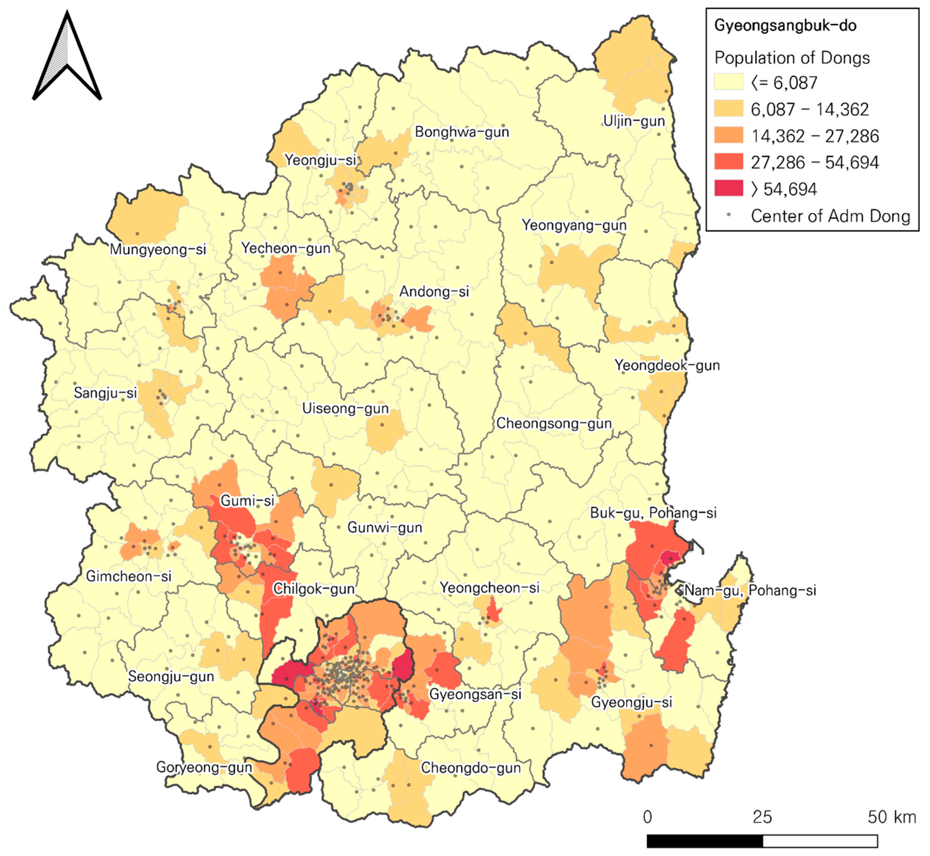
Figure 2 displays the spatial pattern of the population of 468 Dongs and their representative demand areas. It is noticeable that the administrative offices of the Dongs are significantly concentrated in three major cities (> 50,000 residents): Daegu-si in the South, Pohang-si in the Southeast, and Gumi-si in the West, indicating a significant discrepancy in population distribution compared to the Dongs, most other areas where the majority of cities are rural, have populations of less than 6,000.

4. Analysis and Implications

4.1. Assessment of service coverage by planning scenarios

Note that traditional p-dispersion and the maxisum dispersion models often produce multiple optimal solutions (i.e., multiple planning scenarios) if identical distances exist among different pairs of selected facilities, which makes difficult assess them. In contrast, the p-DIME model produces a single optimal solution because the objective function is determined by the allocations between demand areas and facilities that yield the greatest service coverage efficiency. To compare the results, all instances for p=2 to 40 were solved for both the p-DIME and the p-maxisum models using the commercial optimization solver ILOG CPLEX 12.8 on an Intel Core i7-4790 3.60GHz with 16GB of RAM in a computational environment. Table 1 provides the optimal solutions for selected p (= 2, 10, 20, 30, 31, and 40) for the maxisum dispersion (column A) and the p-DIME model (column B). Additionally, the objective function value for the current location of 31 LEMIs (column C) is included as a reference to assess the efficiency of the current arrangements compared to the ideal solutions obtained from the two models.
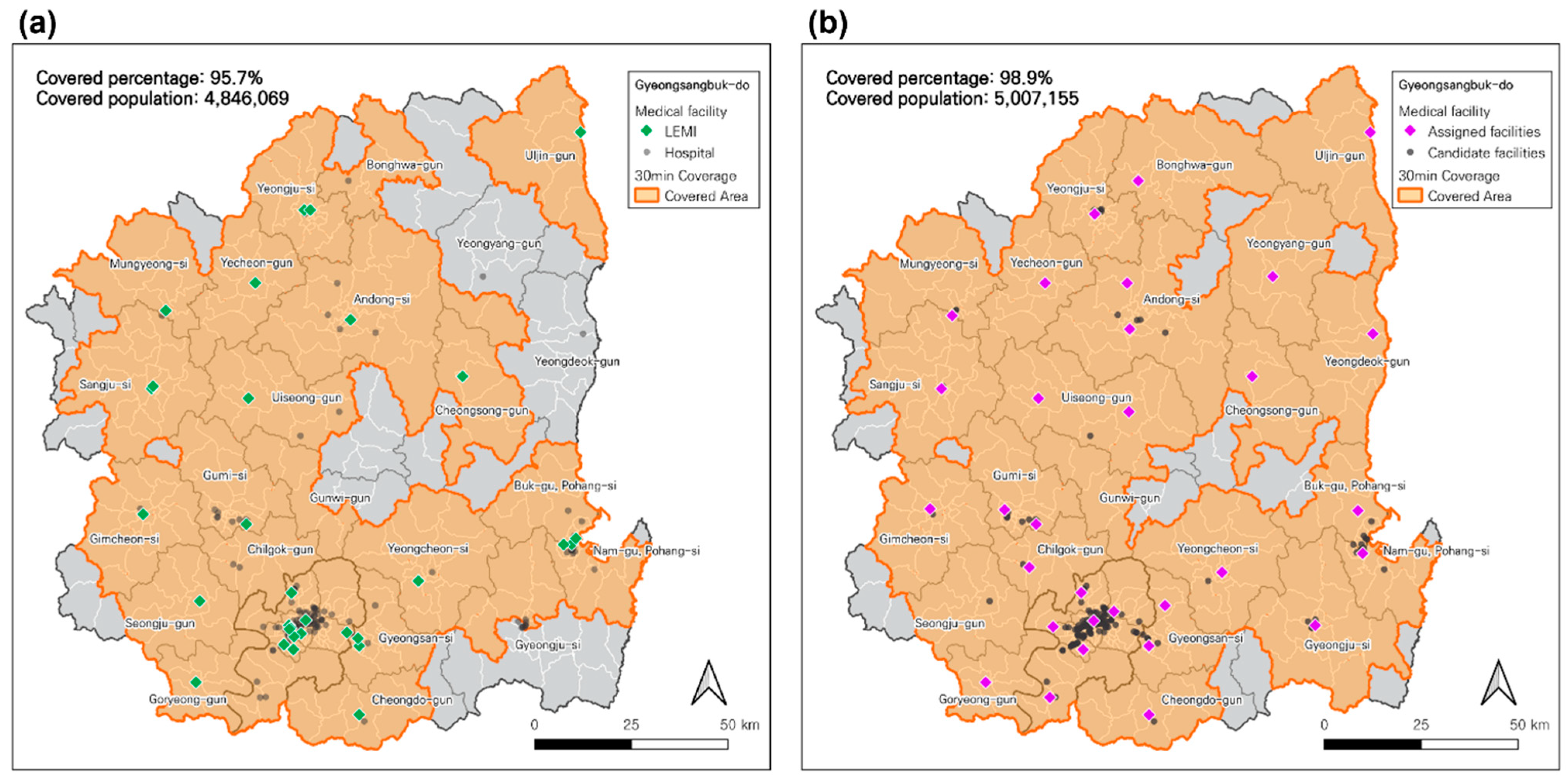
Some noteworthy findings have emerged from the analysis. First, the p-DIME model demonstrates greater efficiency in population coverage compared to the maxisum dispersion model. For instance, if only 10 LEMIs are allowed, the optimal arrangement by the maxisum dispersion model covers 36.8% of the population, whereas the 10-DIME model offers a better coverage, reaching 42.2% of the population. This represents an additional benefit to 277,124 residents (refer to Table 1). These enhanced coverages are observed for all other instances of p. Second, as anticipated, the number of covered populations by LEMIs increases along with the increase of p. However, it is important to observe that significant improvement in coverage is steeply made until p=20, with the maxisum and DIME models reaching 97.6% and 98.1% coverage, respectively. Beyond p=20, there is a marginal improvement until p=40, which is the saturation point to reach the complete coverage of the areas considering a 30-minute travel time distance. In other words, the result suggests that 20 LEMIs would be sufficient to cover the same or greater areas currently served by the 31 LEMIs covers, strongly indicating the inefficiency of the current EMS operations. Third, when comparing the coverage by the current 31 LEMIs (95.7%, 4,846,069) with the coverage by the p-DIME model for p=31, it is evident that more people could be served by the optimal arrangement of LEMIs (98.9%, 5,007,155). This outcome suggests that the current EMS system with 31 LEMIs practices inefficient resource utilization and suffers from spatial disparities in the accessibility of LEMIs.
From a future planning perspective, if we consider only 31 LEMIs for operation, the current coverage can be improved to better serve the demand areas by relocating the least efficient ones among 31 LEMIs based on the solutions from the p-DIME model. Second, if the target planning goal is to maintain the current 96% coverage, the p-DIME model suggests that only 15 LEMIs are needed to achieve a coverage level of 96.8% (with p=15), as the coverage with p=14 falls below 96%. Third, if the concern is to identify areas with significant spatial disparity and/or potential operational inefficiency, mapping the geographic coverage of the current 31 LEMIs (Figure 3a) against the optimal locations of 31 LEMIs determined by the p-DIME model (Figure 3b) can help pinpoint which current LEMIs are candidates for relocation. The result by the p-DIME model in Figure 3b clearly suggests that several LEMIs in the outskirt areas of the province should be dispersed, particularly in the north and south areas, resulting in 98.9% of areas being served. It is evident that if the model uses a less-strict travel-time coverage standard, such as a 45 or 60-minute driving distance, the province would be completely covered with a smaller p.
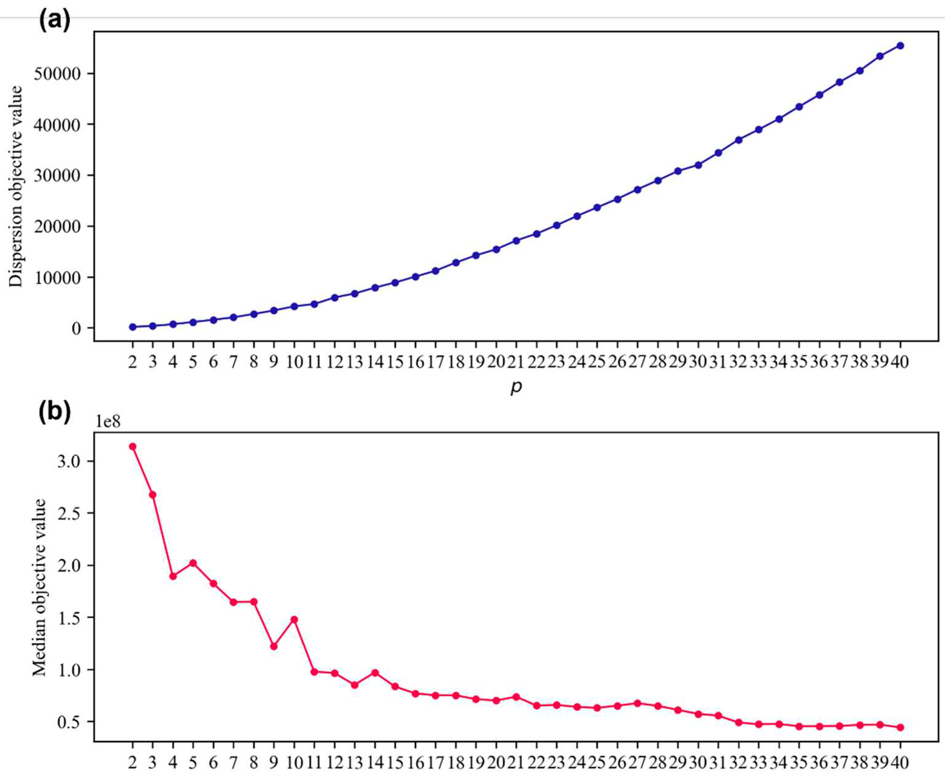
Figure 4 illustrates the change in the objective values of the two objective terms in the p-DIME model: the maximum dispersion part concerning the location decision of LEMIs (Figure 4a) and the median terms for the allocation decision (Figure 4b) with p = 2, 3, …, 40. The objective value for the maximum dispersion part consistently increases, while the median part decreases, clearly demonstrating a trade-off between the dispersion-type versus the median-type problem. It should be noted that the objective value of the median part in Figure 4b often exhibits fluctuations, with a few stepwise transitions observed at p=5, 10, 14, and 21. These fluctuations can be attributed to the behavior of the p-DIME model, which aims to find the global optimal solutions to the dispersed LEMIs for spatial equitable placements and the optimal allocation of demands for the best accessibility to the location of LEMIs.

4.2. Computational efficience of the p-DIME models for planning scenarios

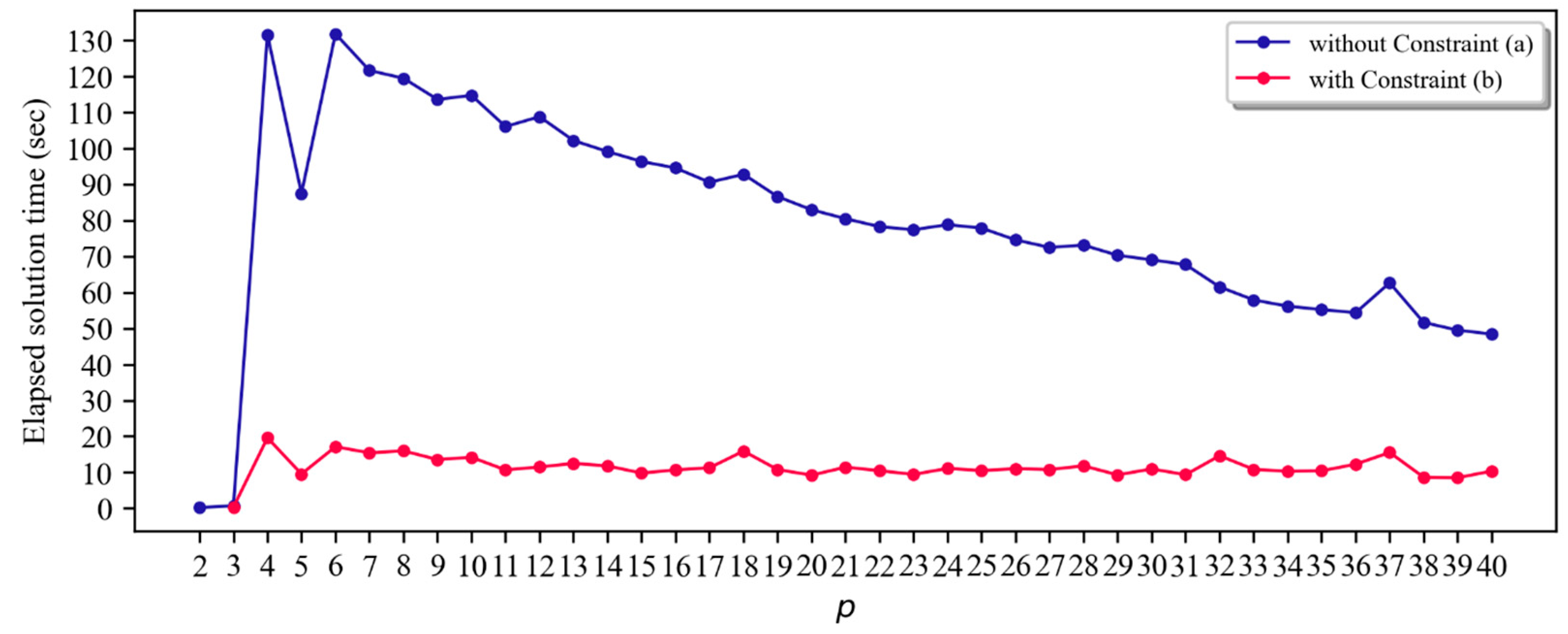
To examine the effectiveness of the APRIL constraint, Table 2 presents computational results comparing the solving performance between the standard p-DIME model (A) and the model with APRIL (B). As mentioned in the previous section, the APRIL constraint was included in the model by obtaining the optimal objective value of the (p–1)th maxisum dispersion model. As shown in the second column in Table 2, both models produced identical objective values for all instances. However, the model with the APRIL constraint significantly reduced the solution time, with a reduction rate ranging from 50% to 88.9%. It is worth noting that the solution times of the p-DIME model with APRIL consistently remain low, taking less than 20 seconds for all p (see Figure 5). In contrast, the p-DIME model without APRIL exhibits greater variability in finding optimal solutions (~130 seconds). This consistently low variability, regardless of the value of p, indicates that the treatment using the APRIL constraint is promising for large instances, though the model is a class of NP-hard. In other words, if solving an instance at a certain p is difficult to solve the problem with optimality, employing a sequential solution procedure (p=1, 2, …, p-2, p-1) can serve as an alternative and effective solution approach.

4.3. Trade-off between dispersion and median of LEMIs

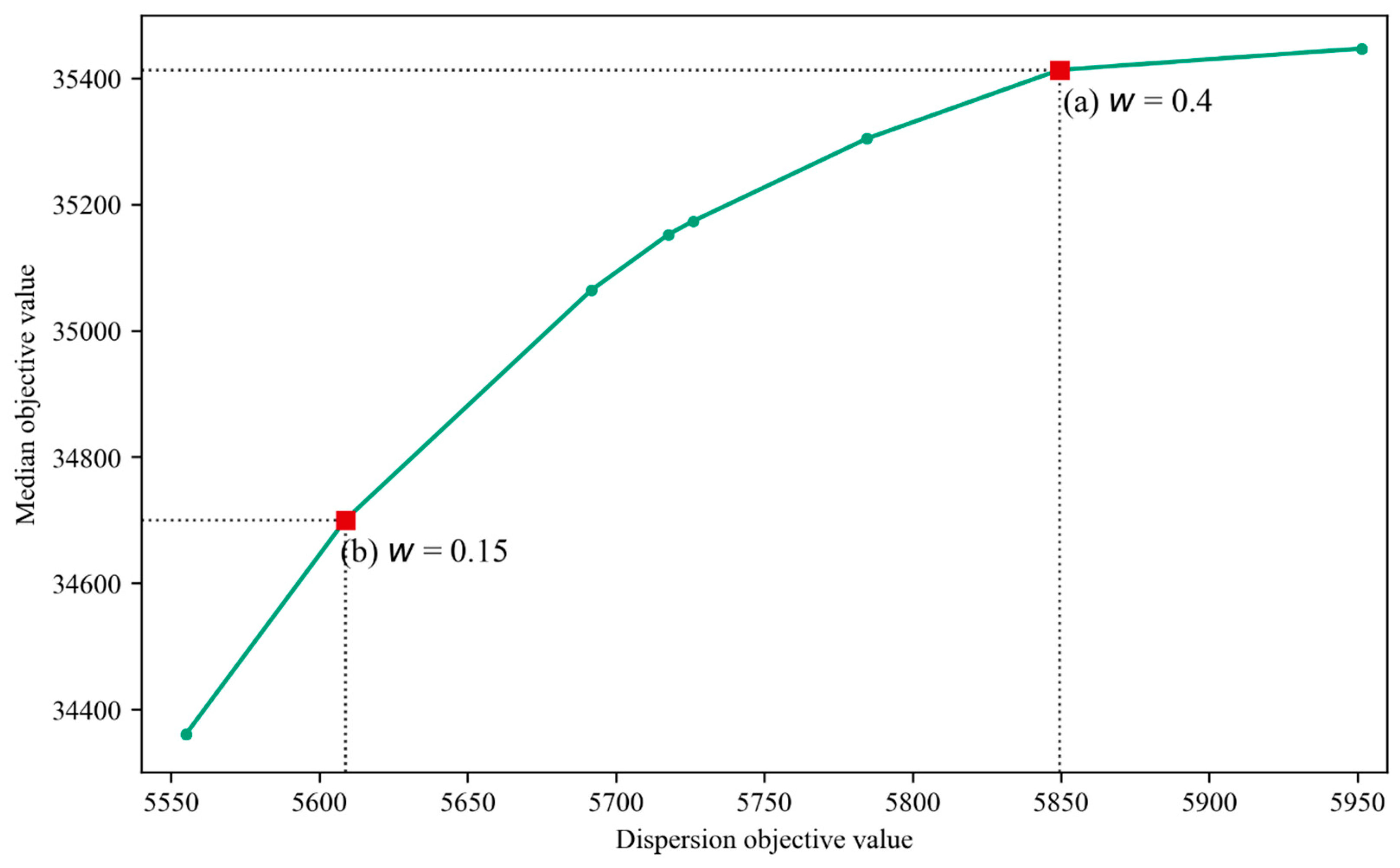
The p-DIME model inherently yields Pareto optimal solutions as it involves a trade-off between two objectives: the dispersion and median problems of facilities. Since these objectives have non-commensurable units, understanding the relationship between them is essential for decision-making in planning scenarios, suggesting that a weighting scheme is employed to explore their relationship. The p-DIME model with a weighting scheme is formulated as (11) to generate a Pareto curve where the weight w ranges from 0 to 1.
w i N j N Z i j d i j ( 1 w ) i N k L f k d i k X i k
Where
w: a weight to the maxisum dispersion term, 0 ≤ w ≤ 1.
Figure 6 depicts a Pareto front between the two objective values for the instance of p=31, which is crucial for evaluating the current arrangement of LEMIs. The x-axis represents the objective values of the first objective term (dispersion), that is the total sum of the distances among LEMIs, and the y-axis corresponds to the second objective (median), the total sum of the weighted distance between demand areas and their assigned LEMIs. The selected results by the weight of 0.10 are displayed. It means, if the emphasis is on achieving spatial equity of the LEMIs for EMS (highlighted point a in Figure 6), it may come at the expense of accessibility efficiency. On the other hand, if the primary concern is ensuring accessibility for demand areas through service coverage provided by LEMIs, the spatial equity via dispersing LEMIs becomes less significant (point b in Figure 6).
Several key implications are worth mentioning from the result in Figure 6, First, although the Pareto curve clearly demonstrates that there is a trade-off between the dispersion of the LEMIs and the median for demand areas, the relationship between the two objective functions is curved-linear, indicating that as the weight given to the dispersion of LEMIs increases, the sensitivity of the allocation of LEMIs quickly decreases. In other words, behavior of the dispersion problem affects greatly to the behavior of the allocation of demands to the LEMIs when even smaller weights are considered. However, once a certain level of LEMI dispersion is reached, e.g., beyond w=0.45, their dispersion becomes less critical to the ideal LEMI arrangement, while demand allocation to the LEMIs becomes more crucial in decision-making. In a planning context, this fact suggests that the decision regarding the establishment of EMS should weight more on the spatial equity (dispersion) over effective accessibility (median). Second, when assessing the performance of current EMS, the ideal arrangement of emergency medical facilities should be strategically designed based on the weight, as two goals pose a conflict with different sensitivity. Third, from a public health policy perspective, re-allocating or redesignating some of the LEMIs entails an opportunity for cost savings in operating LEMIs, while simultaneously improving emergency healthcare coverage for communities that are currently underserved by inefficiently located LEMIs. However, the cost-benefit analysis should be designed as a follow-up modeling if the cost for the relocation of the LEMIs is known as the proposed p-DIME model does not reflect the cost-relevant metrics in the model.

5. Concluding Remarks

From a socio-economic perspective spanning across geography, public health, and planning, this research presents an enhanced location problem for determining the optimal placement of emergency medical facilities. The p-DIME model proposed in this study falls within the category of location-allocation problems, integrating two classes of spatial optimization problems. This model is particularly suitable for situations where the objective is to disperse medical facilities for equitable service coverage while ensuring improved accessibility for demands to the facilities.
Based on the results, the fundamental concept of the p-DIME model enables efficient optimization of LEMIs location and provides valuable insights into achieving equitable access at the same time enhanced accessibility for various medical service provision scenarios. These insights can be applied to scenarios such as facility relocation and demand reassignment. Furthermore, the p-DIME model can be extended to incorporate additional dimensions of supply restrictions (e.g., number of doctors, facility capacity, and external impacts due to service failures, and relocation expense of the LEMIs) into the model formulation, thus sophisticating its applicability in realistic decision-making processes for siting emergency medical facilities. Much of the research regarding the application of dispersion-based location problems has been primarily focused on the separation of noxious or obnoxious facilities. However, certain types of facilities, especially medical service facilities targeted for citizens’ welfare and security, should be accessible while incorporating the spatial equity of the service into the solution to serve the underserved areas as much as possible.
From a modeling perspective, location-allocation problems can benefit from adapting bounding techniques, as used in the p-DIME model, to ensure optimal solutions for large-scale instances rather than relying solely on heuristic approaches. Our approach is inspired by recent literature [46], which seeks to integrate spatially informed geographic patterns with the optimization of location-allocation problems. While the bounding technique helps enhance solvability, there's room for exploring additional solving strategies to eliminate unnecessary constraints or decision variables because any combination of different classes of location problems increases the complexity of the models. This area is a potential avenue for future research, going beyond the current conventional modeling approach.

Author Contributions

Conceptualization, Changwha Oh, Yongwan Chun and Hyun Kim; methodology, Changwha Oh and Hyun Kim; software, Changwha Oh; validation, Changwha Oh, Yongwan Chun and Hyun Kim; formal analysis, Changwha Oh; investigation, Changwha Oh; resources, Changwha Oh; data curation, Changwha Oh; writing—original draft preparation, Changwha Oh; writing—review & editing, Hyun Kim and Yongwan Chun; visualization, Changwha Oh; supervision, Hyun Kim; project administration, Yongwan Chun; funding acquisition, Yongwan Chun. All authors have read and agreed to the published version of the manuscript.

Funding

This research is supported by National Science Foundation (Award number: 1951344).

Data Availability Statement

Not applicable (public data).

Acknowledgments

In this section, you can acknowledge any support given which is not covered by the author contribution or funding sections. This may include administrative and technical support, or donations in kind (e.g., materials used for experiments).

Conflicts of Interest

The authors have no conflicts of interest to disclose.

References

  1. Shin SD, Ong MEH, Tanaka H, Ma MH-M, Nishiuchi T, Alsakaf O, Karim SA, Khunkhlai N, Lin C-H, Song KJ, Ryoo HW, Ryu HH, Tham LP, Cone DC. Comparison of Emergency Medical Services System Across Pan-Asian Countries: A Web-based Survey. Prehospital Emergency Care 2012, 16(4), 477-496. [CrossRef]
  2. Arnold JL, Song HS, Chung, JM. The Recent Development of Emergency Medicine in South Korea. Annals of Emergency Medicine 1998, 32(6), 730-735. [CrossRef]
  3. 3Herbert A, Gilbert R, González-Izquierdo A, Pitman A, Li L. 10-y Risks of Death and Emergency Re-admission in Adolescents Hospitalised with Violent, Drug- or Alcohol-Related, or Self-Inflicted Injury: A Population-Based Cohort Study. PLoS Med 2015, 12(12),e1001931. [CrossRef]
  4. Chea H. Kim H. Shaw S. Chun Y. Assessing trauma center accessibility for healthcare equity using anti-covering approach. International Journal of Environmental Research and Public Health 2022, 19(3), 1459. [CrossRef]
  5. Lee H. Spatial Distribution of the Emergency Medical Facilities and Spatial Disparity of the Demand-Supply Level for the Emergency Medical Service. Journal of the Korean Association of Regional Geographers 2004, 10(3), 606-623.
  6. Cho J, You M, Yoon Y. Characterizing the influence of transportation infrastructure on Emergency Medical Services (EMS) in urban area – A case study of Seoul, South Korea. PloS ONE 2017, 12(8), e0183241. [CrossRef]
  7. Khubchandani JA, Shen C, Ayturk D, Kiefe CI, Santry HP. Disparities in access to emergency general surgery care in the United States. Surgery 2017, 163, 243-250. [CrossRef]
  8. Ge E, Su M, Zhao R, Huang Z, Shan Y, Wei X. Geographical disparities in access to hospital care in Ontario, Canada: a spatial coverage modelling approach. BMJ open 2021, 11(1). [CrossRef]
  9. Mao L, Nekorchuk D. Measuring spatial accessibility to healthcare for populations with multiple transportation modes. Health & place 2013, 24, 115-122. [CrossRef]
  10. Im J, Park J. Spatial Distribution of Underserved Emergency Medical Service Areas and Their Residents’ Atrributes – Focusing on Chungnam Province. Journal of Korea Planning Association 2016, 51(1), 63-75. [CrossRef]
  11. Yun SB, Kim S, Ju S, Noh J, Kim C, Wong MS, Heo J. Analysis of accessibility to emergency rooms by dynamic population from mobile phone data: Geography of social inequity in South Korea. PLoS ONE 2020, 15(4), e0231079. [CrossRef]
  12. National Geographic Information Institute. 2020 National Territorial Monitoring Report, NGII, Suwon: South Korea; 2021.
  13. Ahmadi-Javid A. Seyedi P. Syam SS. A Survey of Healthcare Facility Location. Computers & Operations Research 2017, 79, 223-263. [CrossRef]
  14. Kuby MJ. Programming Models for Facility Dispersion: The p-Dispersion and Maxisum Dispersion Problems. Geographical Analysis 1987, 19(4), 315-329. [CrossRef]
  15. Hakimi SL. Optimum Locations of Switching Centers and the Absolute Centers and Medians of a Graph. Operations Research 1964, 12(3), 450-459. [CrossRef]
  16. Li X, Zhao Z, Zhu X, Wyatt. T. Covering models and optimization techniques for emergency response facility location and planning: a review. Mathematical Methods of Operations Research 2011, 74, 281-310. [CrossRef]
  17. Toregas C, Swain R, ReVelle C, Bergman, L. The Location of Emergency Service Facilities. Operations Research 1971, 19(6), 1363-1373. [CrossRef]
  18. Church R, ReVelle C. The maximal covering location problem. In Papers of the regional science association 1974, 32(1), 101-118.
  19. Church RL, Murray AT. Business Site Selection, Location Analysis and GIS. Hoboken. NJ: John Wiley & Sons; 2009.
  20. Daskin M, Stern E. A Hierarchical Objective Set Covering Model for Emergency Medical Service Vehicle Deployment. Transportation Science 1981, 15(2), 137-152. [CrossRef]
  21. Eaton D, Daskin M, Simmons D, Bulloch B, Jansma G. Determining Emergency Medical Service Vehicle Deployment in Austin, Texas. Interfaces 1985, 15(1), 96-108. [CrossRef]
  22. Jia H, Ordones F, Dessouky M. A Modeling Framework for Facility Location of Medical Services for Large-Scale Emergencies. IIE Transactions 2007, 39(1), 41-55. [CrossRef]
  23. Ye H, Kim H. Locating healthcare facilities using a network-based covering location problem. GeoJournal 2016, 81, 875–890. [CrossRef]
  24. ReVelle, CS, Swain RW. Central facilities location. Geographical Analysis 1970, 2(1), 30-42. [CrossRef]
  25. Caccetta L, Dzator M. Heuristic Methods for Locating Emergency Facilities. Proceedings Modsim 2005.
  26. Indriasari V, Mahmud AR, Ahmad N, Shariff ARM. Maximal Service Area Problem for Optimal Siting of Emergency Facilities. International Journal of Geographical Information Science 2010, 24(2), 213-230. [CrossRef]
  27. Daskin MS. Network and discrete location: models, algorithms and applications. Hoboken. NJ: John Wiley & Sons; 1995.
  28. Shier DR. A min-max theorem for p-center problems on a tree, Transportation Science, 1977, 11(3), 243-252.
  29. Lei TL, Church RL. A Unified Model for Dispersing Facilities. Geographical Analysis 2013, 45, 401-418. [CrossRef]
  30. Curtin KM. Church RL. A Family of Location Models for Multiple-Type Discrete Dispersion. Geographical Analysis 2006, 38, 248-270. [CrossRef]
  31. Erkut E, Neuman S. Analytical Models for Locating Undesirable Facilities. European Journal of Operational Research 1989, 40, 277-291. [CrossRef]
  32. Curtin KM, Church RL. Optimal Dispersion and Central Places. Journal of Geographical Systems 2007, 9, 167-187. [CrossRef]
  33. Erkut E. Neuman S. Comparison of Four Models for Dispersing Facilities. INFOR: Information Systems and Operational Research 1991, 29(2), 68-86. [CrossRef]
  34. Erkut E. Neuman S. A multiobjective model for locating undesirable facilities. Annals of Operations Research 1992, 40, 209-227. [CrossRef]
  35. Maliszewski PJ. Kuby MJ. Horner MW. A Comparison of Multi-objective Spatial Dispersion Models for Managing Critical Assets in Urban Areas. Computers, Environment and Urban Systems 2012, 36, 331-341. [CrossRef]
  36. Erkut E. The discrete p-dispersion problem. Journal of Operational Research 1990, 46(1), 48-60. [CrossRef]
  37. Kim H, O’Kelly ME. Reliable p-hub location problems in telecommunication networks. Geographical Analysis 2009, 41(3), 283-306. [CrossRef]
  38. Garey MR, Johnson DS. Computers and intractability. San Francisco: Freeman; 1979.
  39. Akinc U, Khumawala BM. An Efficient Branch and Bound Algorithm for the Capacitated Warehouse Location Problem. Management Science 1977, 23(6), 585-594. [CrossRef]
  40. IBM. Branch and Cut in CPLEX, ILOG CPLEX Optimization Studio 12.10.0 Documentation; 2019. https://www.ibm.com/docs/en/icos/12.10.0?topic=concepts-branch-cut-in-cplex.
  41. Guzelsoy M, Nemhauser G, Savelsbergh M. Restrict-and-relax search for 0-1 mixed-integer programs. European Journal on Computational Optimization 2013, 1, 201–218. [CrossRef]
  42. Kim H, Chun Y, Kim K. Delimitation of Functional Regions Using a p-Regions Problem Approach. International Regional Science Review 2015, 38(3), 235-263. [CrossRef]
  43. Lerner EB, Moscati RM. The Golden Hour: Scientific Fact or Medical “Urban Legend”?. Academic Emergency Medicine 2001, 8, 758-760. [CrossRef]
  44. Vanderschuren M, McKune D. Emergency Care Facility Access in Rural Areas within the Golden Hour?: Western Cape Case Study. International Journal of Health Geographics 2015, 14(5), 1-8. [CrossRef]
  45. Cohon JL. Multiobjective programming and planning. New York: Academic Press; 1978.
  46. Griffith D, Chun Y, Kim H. Spatial autocorrelation informed approaches to solving location–allocation problems. Spatial Statistics 2022. [CrossRef]
  47. Jenks GF. Optimal data classification for choropleth maps. Department of Geography, University of Kansas Occasional Paper 1977.
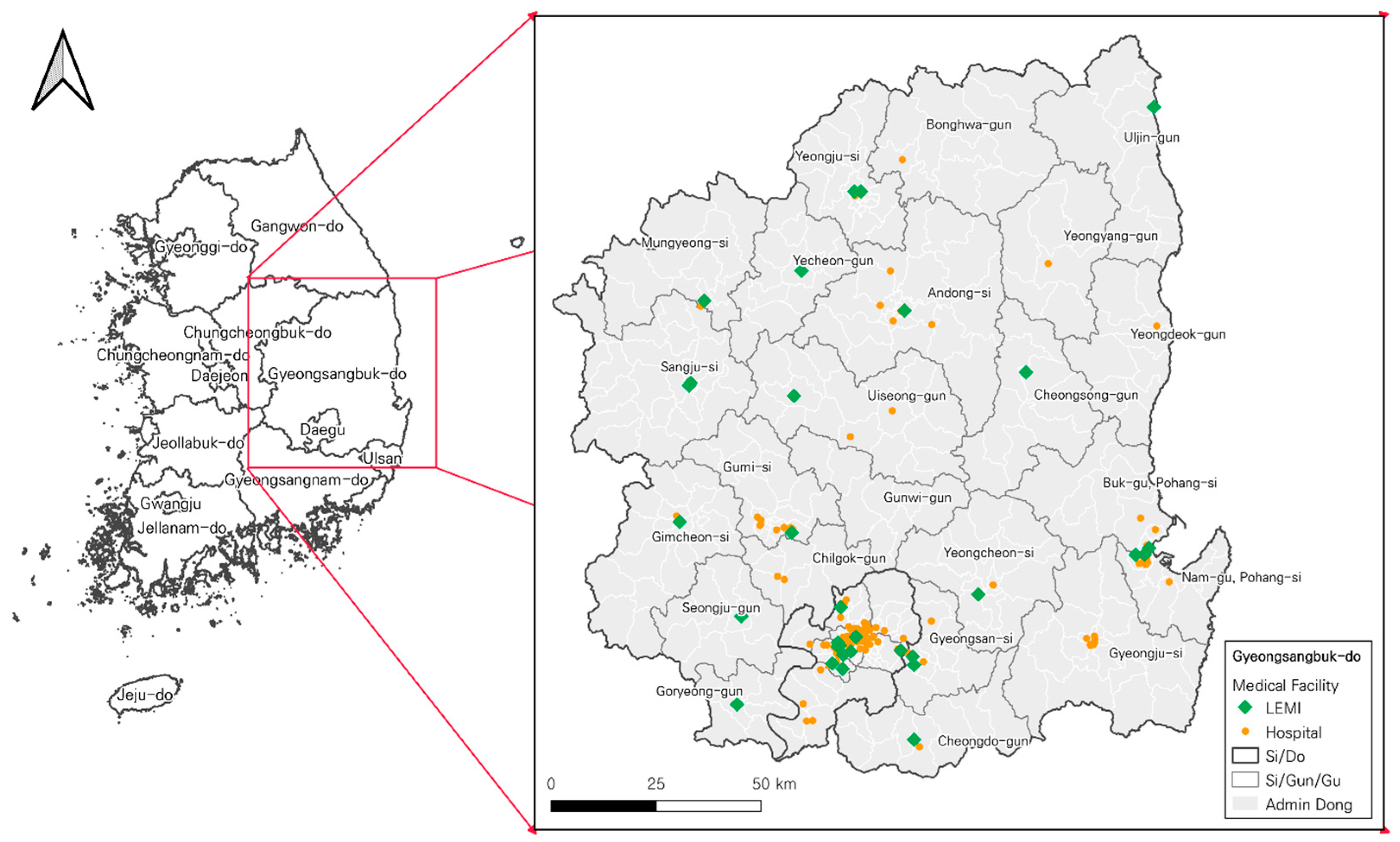
Figure 1. Research extent and the distribution of the candidate medical facilities for LEMIs. Note: green dots represent the location of current LEMIs.
Preprints 89565 g001
Figure 2. Population distribution of the research area. Note: The natural breaks method was used as a classification method to visualize the distribution of the registered population [47].
Preprints 89565 g002
Figure 3. Comparison of geographic coverage by the current 31 LEMIs (a) and the LEMIs by the p-DIME model when p=31 (b).
Preprints 89565 g003
Figure 4. Change of two objective values of the p-DIME model with p. (a) Change of the objective function values on the maxisum dispersion terms (locations) (b) Change of the objective function values on the median terms (allocations).
Preprints 89565 g004
Figure 5. Comparison of solution times: (a) p-DIME model without APRIL (a) vs. (b) the p-DIME with APRIL constraint.
Preprints 89565 g005
Figure 6. Trade-off between dispersion and median of LEMIs in the p-DIME model (p = 31). Note: For a better visualization of Pareto curve, the population weighted demands are re-scaled by 1/10,000.
Preprints 89565 g006
Table 1. Population coverage by the maxisum dispersion and p-DIME model for selected p.
p Maxisum Dispersion (A) p-DIME (B) Current location of the LEMIs (C)
Covered population % Covered population % Covered population %
2 196,780 3.9 196,780 3.9 - -
10 1,861,864 36.8 2,138,988 42.2 - -
20 4,942,982 97.6 4,967,938 98.1 - -
30 4,980,951 98.3 4,999,462 98.7 - -
31 4,980,951 98.3 5,007,155 98.9 4,846,069 95.7
40 4,986,485 98.5 5,011,482 98.9 - -
* Note: Current distribution of medical facilities cannot provide a 100% covered population because a few administrative units (i.e., Dongs) cannot be served by candidate medical facilities under the 30-minute travel time coverage standard.
Table 2. Computational results of the model with auxiliary pre-informed lower bound (APRIL) constraint.
p Objective Value p-DIME without APRIL (A) p-DIME with APRIL (B) Sol. Time reduction
Time(s) (c) Nodes Iterations Time(s) (d) Nodes Iterations
2 173.6 0.2 0 0 - 0 - -
3 368.1 0.7 0 1,785 0.4 0 0 50.7
10 4,213.7 114.7 0 25,583 14.2 0 25,932 87.6
20 15,411.7 82.9 0 18,868 9.2 0 18,057 88.9
30 31,978.6 69.0 0 17,697 11.0 0 18,484 84.1
31 34,360.8 67.7 0 22,218 9.4 0 22,031 86.2
40 55,478.5 48.4 0 21,181 10.4 0 20,045 78.6
* Note: Solution time reduction (%) = ((c) – (d)) / (c) * 100.
Disclaimer/Publisher’s Note: The statements, opinions and data contained in all publications are solely those of the individual author(s) and contributor(s) and not of MDPI and/or the editor(s). MDPI and/or the editor(s) disclaim responsibility for any injury to people or property resulting from any ideas, methods, instructions or products referred to in the content.
Copyright: This open access article is published under a Creative Commons CC BY 4.0 license, which permit the free download, distribution, and reuse, provided that the author and preprint are cited in any reuse.
Prerpints.org logo

Preprints.org is a free preprint server supported by MDPI in Basel, Switzerland.

Subscribe

© 2024 MDPI (Basel, Switzerland) unless otherwise stated