
Submitted:
30 October 2023
Posted:
01 November 2023
You are already at the latest version
Abstract
Urbanization and climate change have increased the need for stormwater management and nature-based solutions. Decisions made at project level impact the emergence of systemic traits of the stormwater network and the functionality of the catchment areas in urban planning. To that end, it is vital to introduce the decision-making tools for analyzing both the utilities and amenities of nature-based solutions (NBS) to increase their adoption to reduce the peak loads in the stormwater system, and to that end, mitigate the impacts of climate change. This paper demonstrates a workflow using drone-based photogrammetry, 3D modeling, and simulation software to generate visual and functional models assisting in informed decision-making in the design of stormwater systems as functional landscape architecture. Using aerial data from drones and modeled design solutions, the proposed workflow simulates rain events, infiltration, evaporation, water flow, and accumulation of stormwater in a way that allows the visual and quantified analysis of detailed landscape architecture designs. The paper provides an example of a rooftop site simulation demonstrating the infiltration and flow of water to the drainage. The visual decision-making method provided can aid in investment decisions for functional landscape design in support of stormwater management.
Keywords:
aerial
; data
; drones
; urban
; nature-based
; photogrammetry
; design
; software
; decision-making
; stormwater
; management
1. Introduction
Urban stormwater runoff is a significant environmental challenge that threatens human and ecological health across cities worldwide and calls for urban stormwater management (USM) [1,2,3,4,5]. The continued urbanization and changing climate have exacerbated the problem [6], highlighting the need for effective stormwater management solutions [7]. However, conventional engineered stormwater systems commonly lack combined functionality and design quality, leaving much to be desired in terms of visual and architectural quality in the artful rainwater design (ARD) [8]. The concept of ARD shares common objectives with an earlier approach of “infra-garden” to support ecological and social values in stormwater management [9]. Both approaches aim at combining functional performance and artistic, visual, and emotional qualities to architectural experiences that promote livable and resilient cities.
Novel trends in stormwater management suggest the use of nature-based solutions (NBSs) in the planning of urban rainwater systems, mainly in the European Union since 2015 [10]. Apart from the functional performance, the social benefits with aesthetic and place-making qualities are considered as quintessential properties of NBSs [11]. However, small-scale NBSs associated with the urban fabric are effective only in large numbers and systemic implementation [12]. To that end, there is a need to investigate how to increase and encourage the adoption of NBSs as part of the urban drainage system.
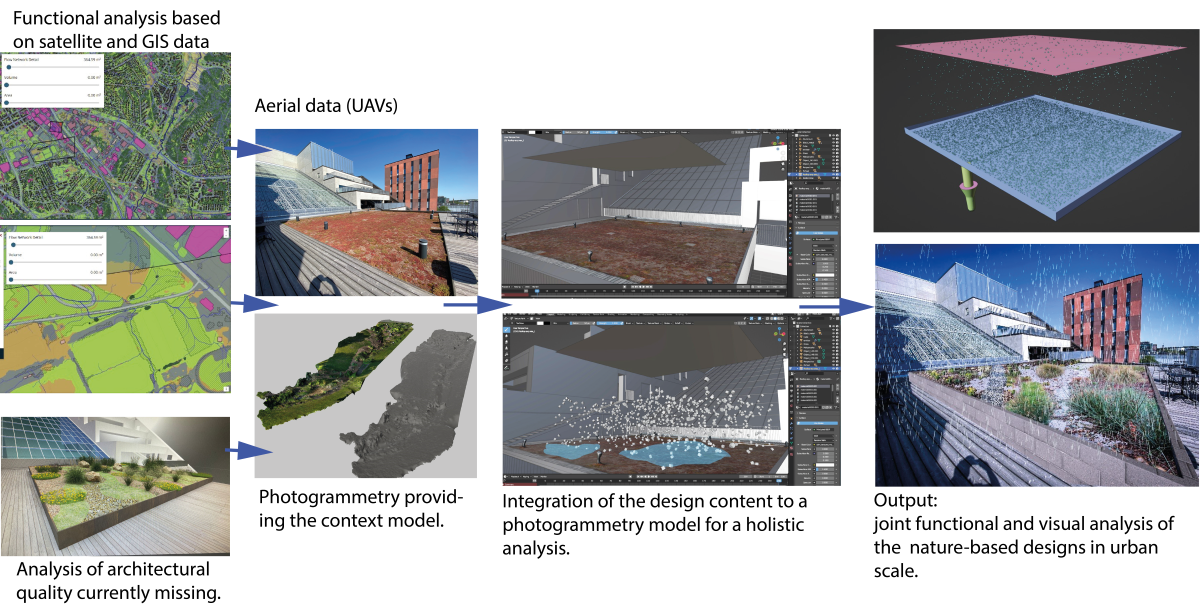
The objective of this paper is to provide a demonstration of a drone-based data collection and design workflow delivering an approach for assessing both the amenities and utility performance of a design for a specific project area. A green roof of a campus building was used in this study as a test and demonstration location for the workflow. The analysis of amenities of NBS is grounded in subjective and project-specific design aspirations while the investigation of utilities offers parameters with metrics, such as the infiltration capacity of the ground to absorb stormwater, to analyze the functionality of the stormwater system through a computational approach.
This study consisted of two phases, 1) the current applications of drone data to the design of stormwater management systems were investigated, 2) the implementation of a design workflow was investigated. The aim of the first phase was to find out to what extent the current practice and workflows support the decision-making of the functionality and aesthetic quality of the stormwater systems in small and medium urban scale projects typically subject to real estate investments. In the second stage, a design workflow was investigated to provide prescriptive advice for design practitioners, the software development community, and researchers for further development of workflows based on aerial imaging, modeling, and design software to achieve more informative design methods for decision-making in projects having the potential to involve a small-scale urban NBS.
The paper aims to explore the use of aerial imaging to support the analysis of amenities and utilities of smaller-scale urban NBSs by answering the following research questions:
- In what ways aerial data has been used in support of designing small-scale urban NBSs?
- Is there a way to use aerial data as a rapid assessment method of the amenities and utilities of urban NBSs?
- How could a computational workflow be established combining aerial data and 3D design information to create a visual and functional representation of a prospect NBS for decision-making purposes in urban projects?
1.2. Current Trends of Using drone-Based Aerial Data for NBSs and Stormwater Design
The performance of stormwater systems has been under scrutiny for an extended period of time due to impairments and knowledge gaps in stormwater management actions and impacts of the urban landscape and grey infrastructure on local and regional hydrology [13,14], and pollution in the runoff waters [15,16]. At the same time, the municipalities commonly work under constrained resources for stormwater management resulting in the need to target the measures with the most impact on the water quality which is a complex task to accomplish [17]. The effectiveness of the measures may not fully comply with the design intentions, and to that end, active monitoring has been suggested to ensure compliance [18]. However, laborious active monitoring and data collection on the properties of water, such as the surface flow or water quality, have limited capacities to provide direct prescriptive advice and guidance for designing stormwater solutions in other areas and specific sites. In turn, aerial data can offer means for data-driven decision-making in the local design context. MacDonald [17] has proposed the following taxonomy for drone applications in the emerging field of using Unmanned Aerial Vehicles (UAVs) in stormwater management and system design as:
- A vehicle for better model parametrization. Aerial data can provide spatial data on-demand for higher spatial accuracy than other georeferenced data with low resolution and granularity for improved performance of models [23,24]. Moreover, thermal imaging can produce fine resolution estimates on the ground surface temperatures [25], and surface imperviousness [26]. The detailed properties of the ground can significantly contribute to the development of the modeling approaches from the viewpoint of functional landscape architecture.
- A way to support smart and connected stormwater systems. UAVs are considered as tools for generating data and improving situational awareness [27]. The advantage of emerging autonomous and frequent drone operations can be real-time and frequently update aerial data as a side product from other smart city solutions such as drone logistics or first responders’ operations. The increased availability of detailed and high-resolution data supports the adoption of data-driven stormwater design and management approaches.
The above taxonomy supports the aims of this research in three ways. First, aerial imagery and photogrammetry were investigated as asset management tools to (i) establish a mesh model created through photogrammetry that can be used as a preliminary model to study the stormwater features of the location by altering the assigned mesh properties, such as color and texture, and functional properties, such as imperviousness and roughness of the surface impacting water flow, and (ii), to deliver the surrounding context data of the design area to which the 3D model of the nature-based design solution can be inserted for the analyzing the utilities and amenities of the solution. The above approach helps to estimate the qualitative and quantitative performance of the intended design solution.
Second, for the aim of better parametrization of physical model parameters, it is possible to use measurement-based estimations of imperviousness for each soil and surface type and assign those values to corresponding areas of the surface mesh to simulate the infiltration and flow of the stormwater. For smaller surface areas the approach can be applied manually by selecting the desired parts of the mesh. However, for efficiency and larger surface areas machine learning using semantic segmentation could be applied [28]. The aerial data of UAVs can aid in this task, namely, by providing more detailed and unobstructed imagery in comparison to high-altitude aerial imagery. The tree canopies often prevent the surface analysis from aerial images taken from higher altitudes. Further, in such aerial images the resolution or point cloud densities are insufficient for determining very precise geometries of the surface, such as inclined surfaces or detailed curbsides, to analyze precise surface water flows and pooling of water in detail. To that end, the evaluation of functional landscape architectural design calls for more detailed data about the surroundings.
Third, smart and connected stormwater systems have their roots in individual projects and investment decisions concerning NBSs. To that end, each project and related nature-based design is part of a larger evolving network of site-specific stormwater solutions and contributes to the reduction of loads on the network. Therefore, the decision-making process at the project level should provide an informed process to consider the increased adoption of NBSs in support of creating the network in a coordinated manner.
To conclude, the aim of the work is to investigate the ways drones are currently used for collecting data in support of designing and adopting nature-based stormwater management solutions in urban development projects. Further, the paper aims to introduce a design software-based workflow to support such decision-making processes. The research problem of the study stems from the notion that there is a shortcoming in the available design workflows for analyzing the visual and functional stormwater qualities of architectural nature-based solutions.
In summary, drones can effectively collect data for creating 3D models of the urban location for modeling of surface flows and infiltration of stormwater in a detailed architectural context. Further, the 3D models can be used as preliminary design tools by changing the parameters of the mesh to measure and visualize the functional properties of the design. Lastly, a detailed architectural design can be integrated into the 3D mesh model to provide a visual and functional simulation of the nature-based solution to support the decision-making in investment projects opting for implanting nature-based solutions.
2. Materials and Methods
2.1. Target of the Research
The research targets are urban sites and locations that become objects of urban development and investments. The scale of the site is not limited, but rather, connected to the investment decisions and ways to provide the stakeholders with means for informed decision-making for the adoption of nature-based stormwater management techniques.
For the aims of the research, a test site was selected consisting of a green roof of a campus building. The size of the selected sedum green roof is 25mx25m (625m2) surrounded by terrace areas as hard roof surfaces. The size of the area fits well with the aims of the research to study the solutions as nature-based landscape architecture solutions applicable to other areas other than green roofs, such as courtyards of residential blocks. Additionally, the compact size of the demonstration site helped in the development of the workflow while using limited computational resources.
2.2. Research Approach
First, the study used a literature search to investigate the current use of drones in support of stormwater management and design covering peer-reviewed journals using Google Scholar for the initial investigation of the literature and Scopus search engine for refining the investigation using the search terms described in Table 1 and Table 2.
Second, based on the findings of the literature search the investigation used action research to discover and demonstrate a workflow that could fill the identified gap in the design methodology supporting increased adoption of nature-based stormwater management techniques. Action research is an approach commonly used in discovering workflow and software approaches to solve a practical need [29]. The method was used to investigate the functionality of NBS in simulated rain events in 3D models that were prepared based on aerial data.
2.2. Creation and Application of 3D Mesh Models
2.2.1. Data Collection for Photogrammetry
The objective of the data collection was to create a visually high-quality mesh of the demonstration site. The creation of the mesh model needs to produce a unified mesh surface without any holes in it for the rain event simulations to perform properly. A DJI Mini 3 Pro drone was used to collect 550 aerial images of the test site. The images were post-processed into a 3D mesh model using WebODM software. The demonstration site illustrated in Figure 1 included diffused objects such as perforated steel structures to increase the complexity of the small-scale urban space.
2.2.2. Fast-Track Analysis with Photogrammetry 3D Models
After producing the 3D mesh of the site, the 3D mesh was processed using Blender 4.0 to initially develop and test the workflows that could later be developed inside Blender to more user-friendly design applications with user interfaces, or software solutions using other applications such as game engines.
The first workflow tested aimed to use the model with minimal interventions for analysing the amenities and utilities of an NBS. The test site contained an existing NBS comprising an extensive sedum green roof. After the initial tests without interventions, the following interventions were tested:
- Changing the color of the mesh surface and altering the topography of the surface. This approach can be used to analyse in a streamlined fashion the changes in appearance of the demonstration site caused by desired amenities and the desired functional properties, such as the impact of adding a stormwater reservoir to the design (Figure 2). The deviation of the surface levels can provide liveliness and functional properties to the design such as a retaining pool for stormwater, without having to fully design and model the NBS. Later if the design process is desired to be continued in more detail, the same volumes of stormwater retention pools can be adapted to a more detailed and realistic 3D model, which is also more time-consuming to produce. In a similar fashion, the existing hard surfaces such as terrace pavements can be re-colored to provide an initial appearance of the NBS that can be later designed and modeled in detail.
- Assigning physics properties to the surface. The last application is the most crucial one from the functional point of view as it enables the analysis of the utilities of the applied solutions. Physics properties of the surface may contain the following variables: (i) permeability as the property of the surface to prevent or allow the infiltration of stormwater, (ii) stickiness/surface roughness as the feature impacting the speed of surface flow and transfer through the structural ground layer. The assignment of the above properties to the mesh model is illustrated in Figure 3. Additionally, the rainwater particles may be assigned a parameter estimating feature for evaporation by reducing the lifetime of the particles in the simulation. And finally, the stormwater outflow from a single NBS to the stormwater piping network can be simulated through the accumulation of rainwater particles in the stormwater tank (Figure 4).
2.2.3. Photogrammetry 3D Models for Creating Context Data for the Design
The created photogrammetry 3D model was used as context data for a proxy design of an NBS in the rooftop test location. The approach allows a fast-track design review in the urban context, that is, a rooftop location in the current study. The method is applicable to other locations such as e.g., residential courtyards. The scale of the analysis is mainly limited by the available high-quality aerial imagery and computing capacity. To enable the analysis of the amenities of an NBS, a proxy design of an NBS was created for the demonstration location and inserted into the photogrammetry 3D model (Figure 5). The model was turned into a single unified mesh model with assigned physics variables for the functional mesh areas. Next, we will discuss the workflow for the analysis of the NBS designs based on the integration of 3D NBS design and 3D photogrammetry model.
2.3. Workflow to Analyze NBS Designs
2.3.1. Parametrization and Features of the Model
The 3D NBS model was parameterized according to Figure 2 showing the applied physics parameter and the selected value for it. The surface areas of the mesh were selected manually and stored as selection values in Blender to maintain the option to edit both the selection itself as well as the physics properties assigned to the selection.
2.3.2. Simulation settings of rain events
Next, a rain event was created over a selected period based on the efficient use of available computing resources. The number and duration of rain events can be increased based on demand and the desired detail of the simulation. For efficiency and illustrative purposes, only one rain event is used here. Table 2 describes the rain event.
2.3.3. Simulation
The simulation was implemented using the physics and Cycles render engine inside Blender. The hardware used consisted of a PC with Intel®Core™ i7-9700K CPU @3.60GHz and 32 RAM.
2.3.4. Analysis of the Utilities
The analysis of the functional performance of the design was enabled in two ways. First, the topography of the design with depressions allowed the pooling of the run-off water. The maximum capacity of the reservoir is achieved when the water starts to overflow from the designated pool area to the surroundings. This is an indication of a lack of infiltration capacity, small size of the reservoir, or insufficient piping systems allowing excess water to run off.
Second, the functional performance of the utilities can be measured by modeling a stormwater tank to the system (c.f. Figure 4). The piping solutions correspond to the design requirements of each specific system. For example, the stormwater inlets of the current test site have been modeled and connected to the virtual stormwater tank. In different phases of the simulation, the volume of the run-off water can be measured in the tank. The objective of the approach is to provide a model for comparing different design solutions with different parameters, such as the infiltration capacity of the surface, against the same rain events. In other words, the simulations show the accumulation of stormwater in the tank over the same period and rain events under different design parameters allowing for the analysis of e.g., the retention capacity and rain event-related maximum flow peak reduction effects.
2.3.5. Analysis of the Amenities
The simulation can provide a highly visual presentation of the chain of events, depending on the selected approach. To that end, the artful rainwater design (ARD) becomes possible when the design analysis is combined with integrated negotiation techniques. The aim of such techniques is to enable consensus building and lasting agreements on the selection of design alternatives [30].
3. Results
Based on the findings of the literature investigation, there is a shortage of applications for using drone-based aerial data in support of visual and functional analysis of the performance of architectural NBSs at a detailed design level. Grounded in the findings of the first research question, the second research question aimed to discover a way for rapid and agile use of aerial imagery to investigate the amenities and utilities of urban NBSs. Here, an approach to post-producing the 3D mesh based on photogrammetry was presented. The third research question targeted finding a software-based workflow to integrate detailed NBS architectural design solutions to the photogrammetry model and perform an analysis of the utilities of the solution. To that end, the paper has described an approach to simulate the rain events and their stormwater impact in a visual fashion while analyzing the performance of the test site. The approach was tested with a selected rain event described in Table 2 and the results will be shown next using three different design solutions as the targets of the simulation.
3.1. Results of the Analysis with Design Solutions Integrated into the 3D Model
Three different design versions were analyzed through a simulation: (i) bitumen hard roof, (ii) extensive sedum green roof (existing situation in the test site), and (iii) intensive green roof with an NBS design. The run-off co-efficient used were 0.33 for the extensive green roof and 0.83 for the intensive green roof as pessimistic values for the performance drawing from a comparison of mineral-organic and mineral substrate-based extensive green roofs [31].
The three design alternatives were tested with the same simulated rain events lasting 1:06 minutes with a total precipitation of 34 mm/m2. The results are illustrated in Figure 6, Figure 7 and Figure 8 (start stage and end stage of simulation shown) showing the amount of accumulated water on the ground and in the stormwater tank at the end of the rain event.
4. Discussion
The study investigated an analysis approach to the functional and esthetic properties of roof designs. The utilities and amenities of three different roof typologies were studied as a demonstration of the approach, including (i) a bitumen hard roof, (ii) extensive green roof with sedum, and (iii) intensive green roof.
The study investigated the applicability of aerial imagery for the purposes of analyzing and communicating nature-based solutions for stormwater management. Earlier taxonomies were reviewed in the research. Most of the earlier identified taxonomies focus on the use of drone data for direct measurement and near real-time monitoring [17]. The proposed approach in this study suggests a new taxonomy for strategic design and decision-making through data-driven design. The approach of data-driven design can be achieved by combining the aerial data with 3D modeling and simulation software.
The results of the study suggest that aerial imagery and powerful modeling tools can effectively be used for analyzing the utilities and amenities of NBSs in urban developments at various scales. The use of drones enables the collection of high-resolution aerial images on demand, thus filling the gap in the availability of data as the satellite imagery fails to provide sufficient resolution for design analysis on a detailed urban scale. Further, the imagery collected at the street level provides little or no information on the rooftop level. Therefore, drones can provide a powerful tool for novel approaches to design analysis.
There are two hindrances to larger-scale adoption of the approach. The first is the need to own and operate a drone to collect the data. The second is the availability of affordable photogrammetry software for occasional users. Both hindrances suggest that the approach is currently applicable mainly to professional users. The change may be introduced along the availability of autonomous drone services, such as data collection as a service, and machine learning-based tools enabling the reconstruction of 3D information, for example, through neural radiance fields (Nerfs) as emerging powerful tool to create 3D content from imagery (REF). Such an approach may provide new ways to even higher visual quality of illustrating the designs than the photogrammetry-based approaches.
In its current stage, the workflow presented supports the practical implementation of artful rainwater design (ARD) and fill the gap in the professional design and communication tools supporting the decision-making in the adoption of NBSs in urban contexts. Specifically, the smaller-scale solutions required a detailed study of the surface water flows and urban elements impacting the functionality and architectural quality of the design.
The results of the simulations in three different designs demonstrate the benefits of the NBSs allowing the quantification of the design alternatives. Importantly, the analysis of the visual and architectural qualities can be done within the same metrics, that is, the numeric performance of the designs having the realistic representation of the design simultaneously available. To that end, complementary research on the functional properties of versatile green roof implementations is essential for gaining additional evidence-based knowledge for the parameters that can be used for setting the parameters of simulations.
Limitations of the study include the investigation of the workflow in a single software stack for demonstration purposes. Future studies should consider using different simulation and game development platforms. Additionally, it should be investigated what kind of classification of ground surface types is needed to address the relevant differences in the infiltration capacities of the ground. For building automated and more easy-to-use applications with high capacity for analytics, future research should also look at the applicability of machine learning-based solutions such as semantic segmentation to automatize the workflow and detection of surface properties.
Author Contributions
H.E.; Conceptualization, methodology, investigation, writing—original draft preparation, L.R.; Investigation, visualization, E.N.; project administration, writing—review and editing, and P.L.; funding acquisition. All authors have read and agreed to the published version of the manuscript.
Funding
This research was funded by the Finnish Ministry of Culture and Education, a grant for the Intelligent and Smart Stormwater Management Project (ISMO).
Data Availability Statement
The data presented in this study are openly available in the CSC-IT Center for Science (csc.fi).
Conflicts of Interest
The authors declare no conflict of interest. The funders had no role in the design of the study; in the collection, analyses, or interpretation of data; in the writing of the manuscript; or in the decision to publish the results.
References
- Islam, A.; Hassini, S.; El-Dakhakhni, W. A Systematic Bibliometric Review of Optimization and Resilience within Low Impact Development Stormwater Management Practices. Journal of Hydrology 2021, 599, 126457. [Google Scholar] [CrossRef]
- Goulden, S.; Portman, M.E.; Carmon, N.; Alon-Mozes, T. From Conventional Drainage to Sustainable Stormwater Management: Beyond the Technical Challenges. Journal of Environmental Management 2018, 219, 37–45. [Google Scholar] [CrossRef]
- Burns, M.J.; Fletcher, T.D.; Walsh, C.J.; Ladson, A.R.; Hatt, B.E. Hydrologic Shortcomings of Conventional Urban Stormwater Management and Opportunities for Reform. Landscape and Urban Planning 2012, 105, 230–240. [Google Scholar] [CrossRef]
- Vasconcelos, A.F.; Barbassa, A.P. Sustainable Urban Stormwater Management in Developing Countries: Integrating Strategies to Overcome Brazilian Barriers. Urban Water Journal 2021, 1–16. [Google Scholar] [CrossRef]
- Xu, H.; Randall, M.; Fryd, O. Urban Stormwater Management at the Meso-Level: A Review of Trends, Challenges and Approaches. Journal of Environmental Management 2023, 331, 117255. [Google Scholar] [CrossRef]
- Bai, X.; Shi, P.; Liu, Y. Society: Realizing China’s Urban Dream. Nature 2014, 509, 158–160. [Google Scholar] [CrossRef]
- Grimm, N.B.; Faeth, S.H.; Golubiewski, N.E.; Redman, C.L.; Wu, J.; Bai, X.; Briggs, J.M. Global Change and the Ecology of Cities. science 2008, 319, 756–760. [Google Scholar] [CrossRef]
- Echols, S.; Pennypacker, E. From Stormwater Management to Artful Rainwater Design. Landscape Journal 2008, 27, 268–290. [Google Scholar] [CrossRef]
- MacElroy, W.P.; Winterbottom, D.M. Toward a New Garden: A Model for an Emerging Twenty-First Century Middle Landscape. Critique of Built Works 1997, 4, 10–14. [Google Scholar]
- Li, L.; Chan, F.; Cheshmehzangi, A. Chapter 18 - Nature-Based Solutions and Sponge City for Urban Water Management. In Adapting the Built Environment for Climate Change; Pacheco-Torgal, F., Granqvist, C.-G., Eds.; Woodhead Publishing Series in Civil and Structural Engineering; Woodhead Publishing, 2023; pp. 371–402. ISBN 978-0-323-95336-8.
- Martín, E.G.; Giordano, R.; Pagano, A.; Keur, P. van der; Costa, M.M. Using a System Thinking Approach to Assess the Contribution of Nature Based Solutions to Sustainable Development Goals. Science of The Total Environment 2020, 738, 139693. [Google Scholar] [CrossRef]
- Ruangpan, L.; Vojinovic, Z.; Di Sabatino, S.; Leo, L.S.; Capobianco, V.; Oen, A.M.P.; McClain, M.E.; Lopez-Gunn, E. Nature-Based Solutions for Hydro-Meteorological Risk Reduction: A State-of-the-Art Review of the Research Area. Natural Hazards and Earth System Sciences 2020, 20, 243–270. [Google Scholar] [CrossRef]
- Roodsari, B.K.; Chandler, D.G. Distribution of Surface Imperviousness in Small Urban Catchments Predicts Runoff Peak Flows and Stream Flashiness. Hydrological Processes 2017, 31, 2990–3002. [Google Scholar] [CrossRef]
- Cao, X.; Qi, Y.; Ni, G. Significant Impacts of Rainfall Redistribution through the Roof of Buildings on Urban Hydrology. Journal of Hydrometeorology 2021, 22, 1007–1023. [Google Scholar] [CrossRef]
- Lu, T.; Hughes, J. A Watershed-Based Approach to Link Watershed Health with Effective Riparian Planting and Stream Restoration Using Emergent Technologies at Clean Water Services. In Proceedings of the WEFTEC 2017; Water Environment Federation; 2017. [Google Scholar]
- Wagner, W.E. Stormy Regulation: The Problems That Result When Stormwater (and Other) Regulatory Programs Neglect to Account for Limitations in Scientific and Technical Information. Chap. L. Rev. 2005, 9, 191. [Google Scholar]
- McDonald, W. Drones in Urban Stormwater Management: A Review and Future Perspectives. Urban Water Journal 2019, 16, 505–518. [Google Scholar] [CrossRef]
- Markell, D.L.; Glicksman, R.L. Next Generation Compliance. Nat. Resources & Env’t 2015, 30, 22. [Google Scholar]
- Moy de Vitry, M.; Schindler, K.; Rieckermann, J.; Leitão, J.P. Sewer Inlet Localization in UAV Image Clouds: Improving Performance with Multiview Detection. Remote Sensing 2018, 10. [Google Scholar] [CrossRef]
- Robinson, J.M.; Harrison, P.A.; Mavoa, S.; Breed, M.F. Existing and Emerging Uses of Drones in Restoration Ecology. Methods in Ecology and Evolution 2022, 13, 1899–1911. [Google Scholar] [CrossRef]
- Sanim, K.R.I.; Kalaitzakis, M.; Kosaraju, B.; Kitzhaber, Z.; English, C.; Vitzilaios, N.; Myrick, M.; Hodgson, M.; Richardson, T. Development of an Aerial Drone System for Water Analysis and Sampling. In Proceedings of the 2022 International Conference on Unmanned Aircraft Systems (ICUAS); IEEE; 2022; pp. 1601–1607. [Google Scholar]
- Alevizos, E.; Oikonomou, D.; Argyriou, A.V.; Alexakis, D.D. Fusion of Drone-Based RGB and Multi-Spectral Imagery for Shallow Water Bathymetry Inversion. Remote Sensing 2022, 14. [Google Scholar] [CrossRef]
- Vivoni, E.R.; Rango, A.; Anderson, C.A.; Pierini, N.A.; Schreiner-McGraw, A.P.; Saripalli, S.; Laliberte, A.S. Ecohydrology with Unmanned Aerial Vehicles. Ecosphere 2014, 5, art130. [Google Scholar] [CrossRef]
- Hoffmann, H.; Nieto, H.; Jensen, R.; Guzinski, R.; Zarco-Tejada, P.; Friborg, T. Estimating Evaporation with Thermal UAV Data \hack\newline and Two-Source Energy Balance Models. Hydrology and Earth System Sciences 2016, 20, 697–713. [Google Scholar] [CrossRef]
- Wu, Y.; Shan, Y.; Lai, Y.; Zhou, S. Method of Calculating Land Surface Temperatures Based on the Low-Altitude UAV Thermal Infrared Remote Sensing Data and the near-Ground Meteorological Data. Sustainable Cities and Society 2022, 78, 103615. [Google Scholar] [CrossRef]
- Francos, N.; Romano, N.; Nasta, P.; Zeng, Y.; Szabó, B.; Manfreda, S.; Ciraolo, G.; Mészáros, J.; Zhuang, R.; Su, B.; et al. Mapping Water Infiltration Rate Using Ground and UAV Hyperspectral Data: A Case Study of Alento, Italy. Remote Sensing 2021, 13. [Google Scholar] [CrossRef]
- Josipovic, N.; Viergutz, K. Smart Solutions for Municipal Flood Management: Overview of Literature, Trends, and Applications in German Cities. Smart Cities 2023, 6, 944–964. [Google Scholar] [CrossRef]
- Zamani, V.; Taghaddos, H.; Gholipour, Y.; Pourreza, H. Deep Semantic Segmentation for Visual Scene Understanding of Soil Types. Automation in Construction 2022, 140, 104342. [Google Scholar] [CrossRef]
- Santos, P.S.M. dos; Travassos, G.H. Chapter 5 - Action Research Can Swing the Balance in Experimental Software Engineering. In; Zelkowitz, M.V., Ed.; Advances in Computers; Elsevier, 2011; Vol. 83, pp. 205–276.
- Ahlava, A.; Edelman, H. Urban Design Management: A Guide to Good Practice; Taylor & Francis, 2014.
- Anna, B.; Agnieszka, K.; Bus, A.; Hewelke, E.; Wróbel, M. Comparing the Retention of the Extensive Green Roofs with the Conventional Roof. In; 2019. ISBN 978-3-030-16541-3.
Figure 1.
Demonstration site. The area subject to investigation is marked with a dotted line.
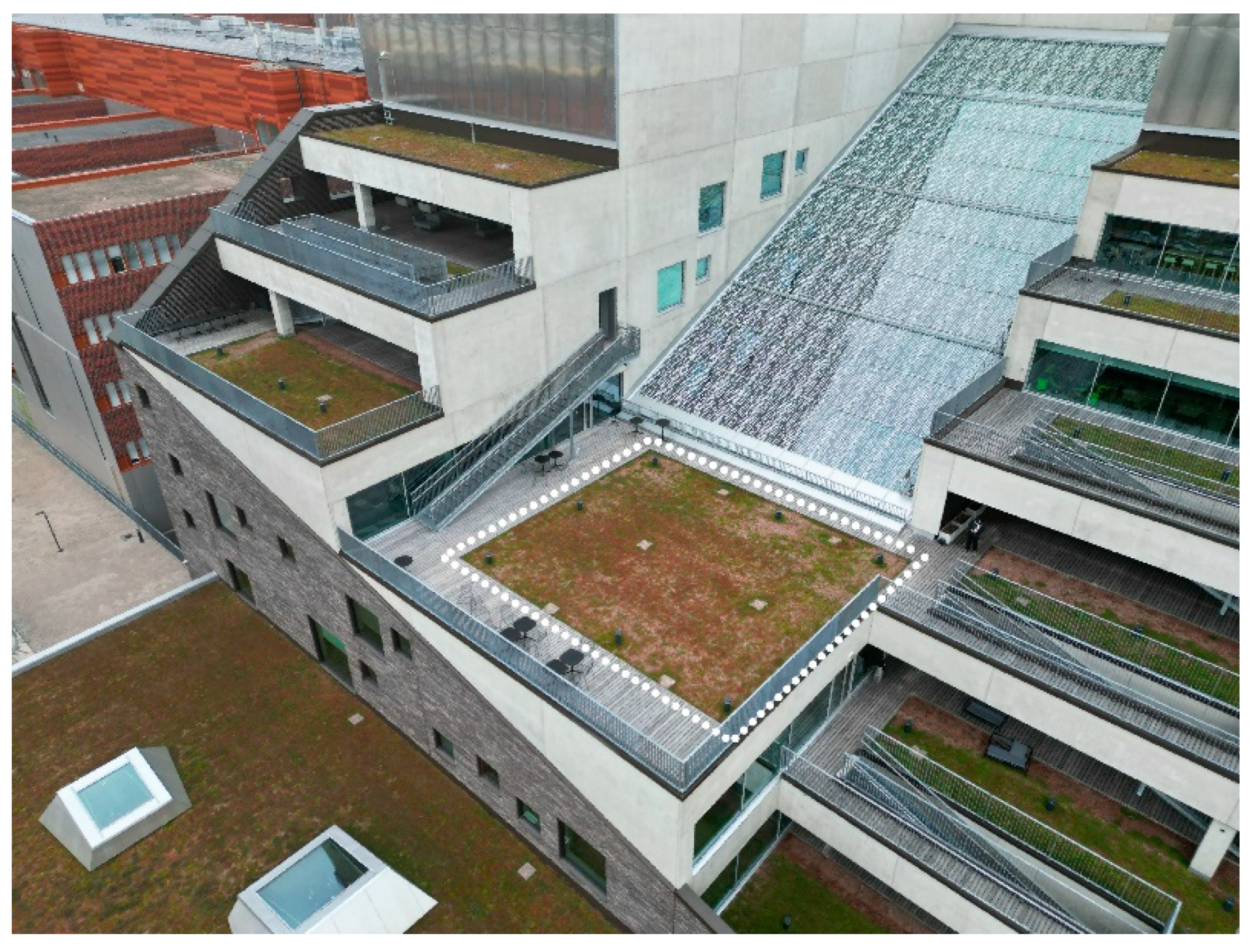
Figure 2.
A rapid method for visualization by changing the color scheme and topography of the mesh model. On the left side is the original 3D mesh of the test site based on photogrammetry. On the right side is the illustration of a surface water reservoir by altering the surface topography of the mesh. Further, the color scheme has been enhanced to highlight the wider adoption of a green roof.
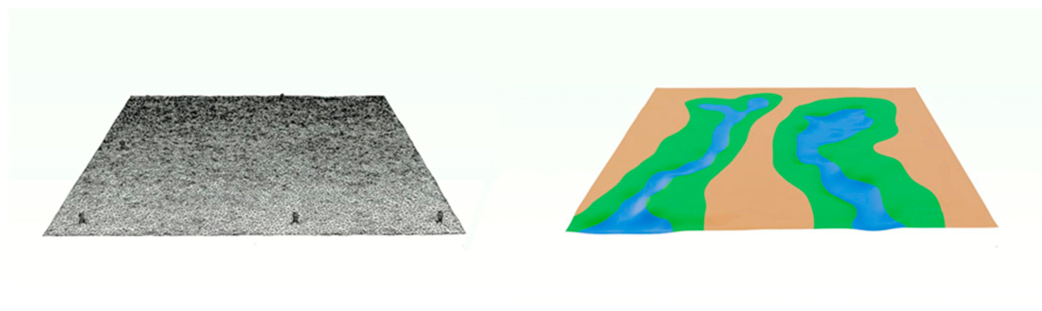
Figure 3.
Illustration of the mesh surface with assigned physics properties.
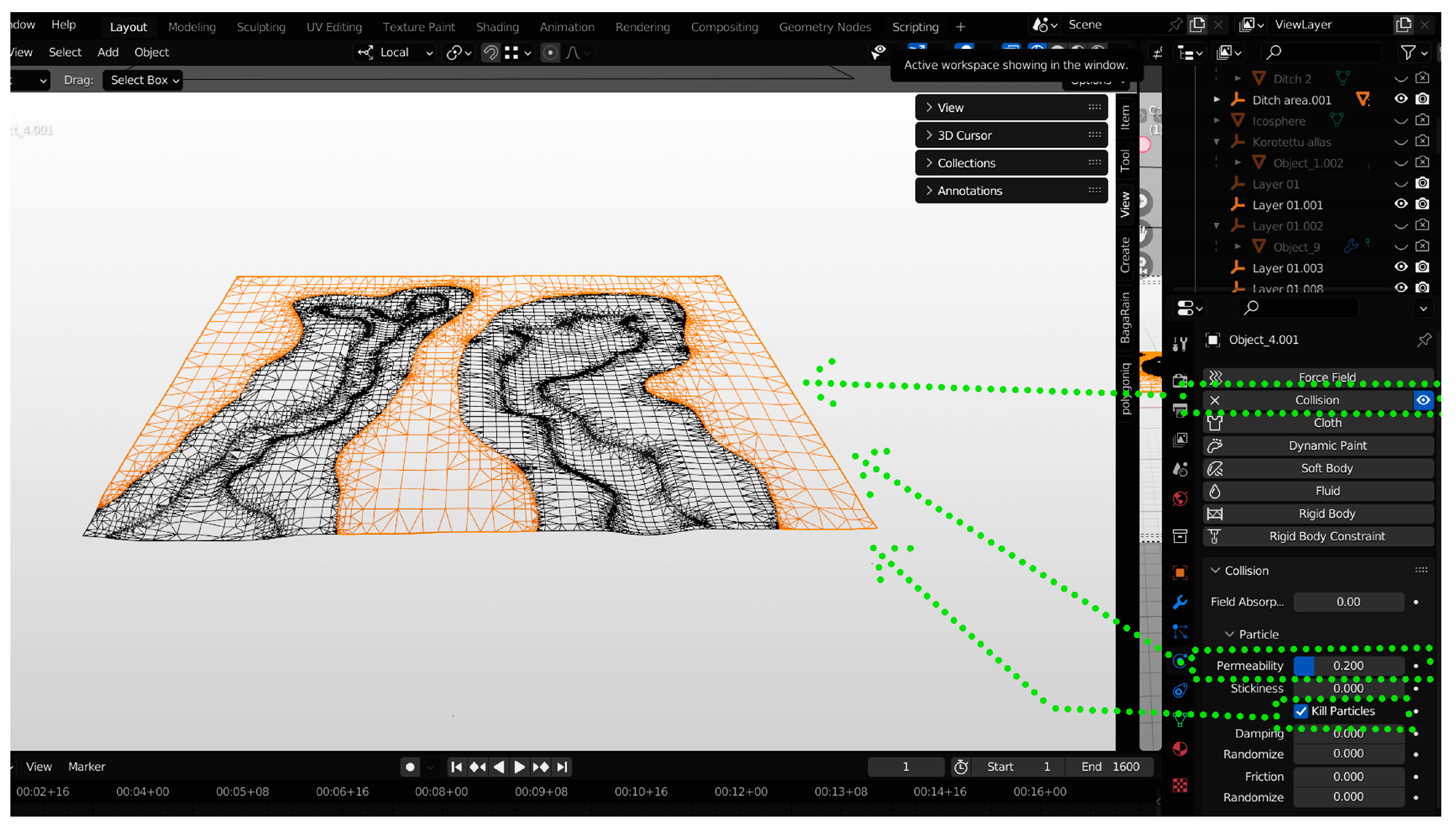
Figure 4.
Principle of the system for the stormwater tank with a volume of 9,0m3.
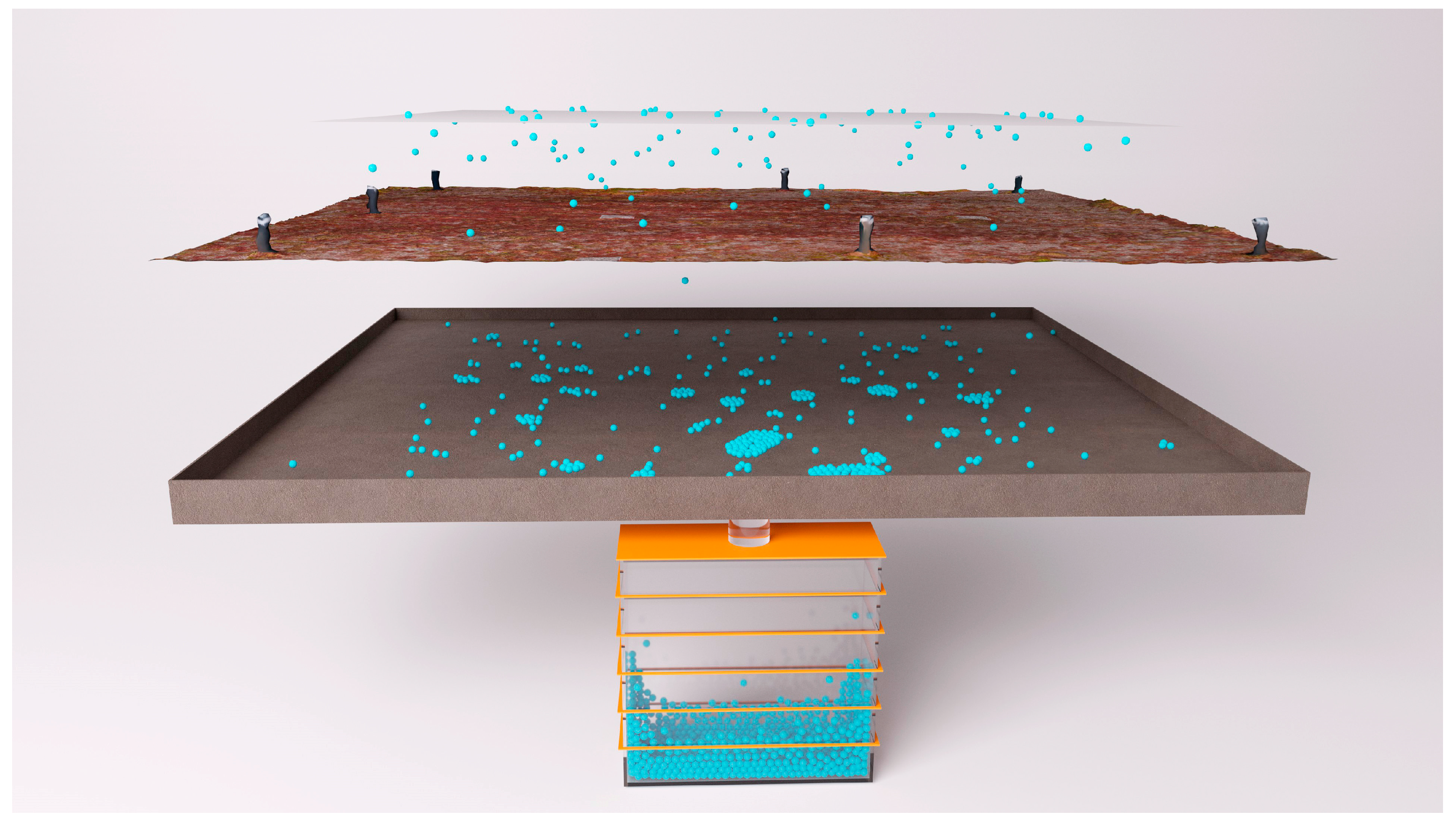
Figure 5.
Integration of detailed 3D NBS design to the context of a photogrammetry model.
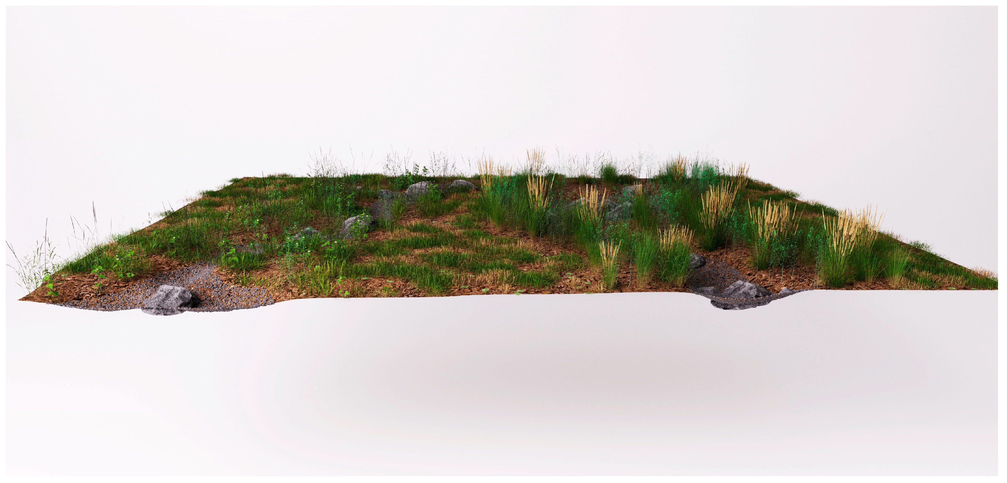
Figure 6.
Visualization of the bitumen roof before and after the simulation. The total accumulated amount of runoff water to the stormwater tank is 8,5 m3.
Figure 6.
Visualization of the bitumen roof before and after the simulation. The total accumulated amount of runoff water to the stormwater tank is 8,5 m3.
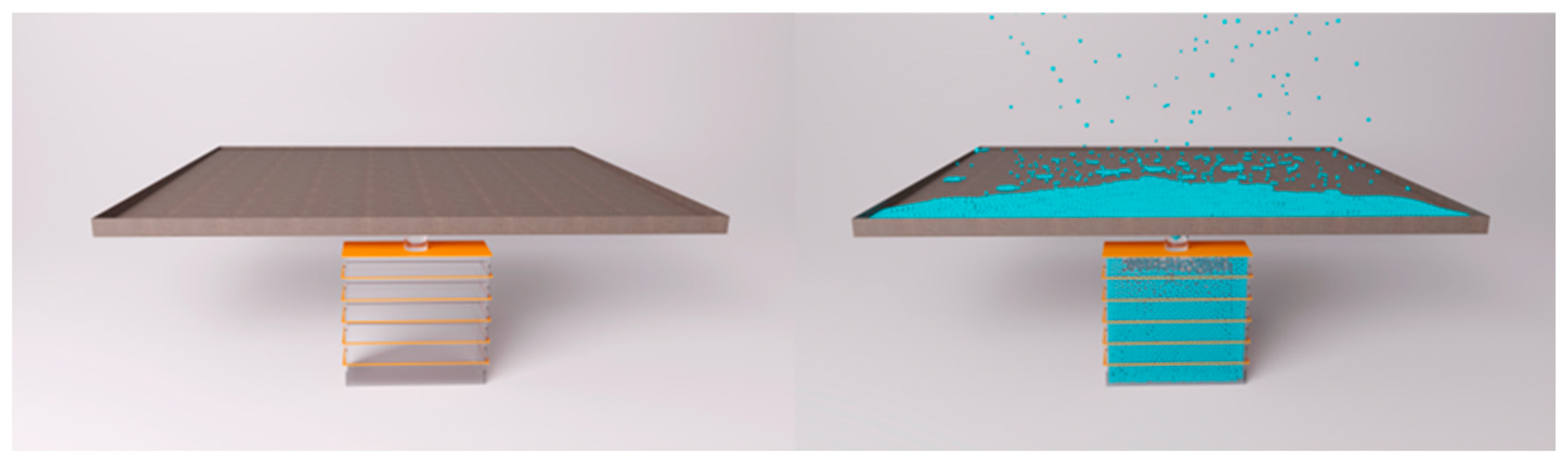
Figure 7.
Visualization of the extensive green roof before and after the simulation. The total accumulated amount of runoff water to the stormwater tank is 7,25 m3.
Figure 7.
Visualization of the extensive green roof before and after the simulation. The total accumulated amount of runoff water to the stormwater tank is 7,25 m3.
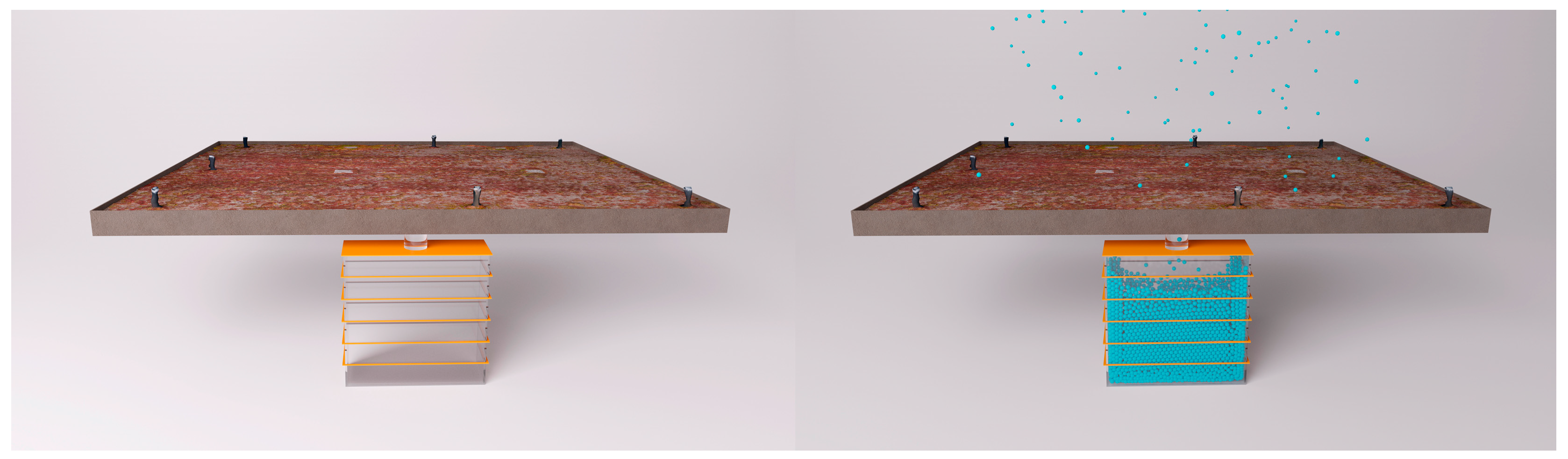
Figure 8.
Visualization of the intensive green roof before and after the simulation. The total accumulated amount of runoff water to the stormwater tank is 0,25 m3.
Figure 8.
Visualization of the intensive green roof before and after the simulation. The total accumulated amount of runoff water to the stormwater tank is 0,25 m3.
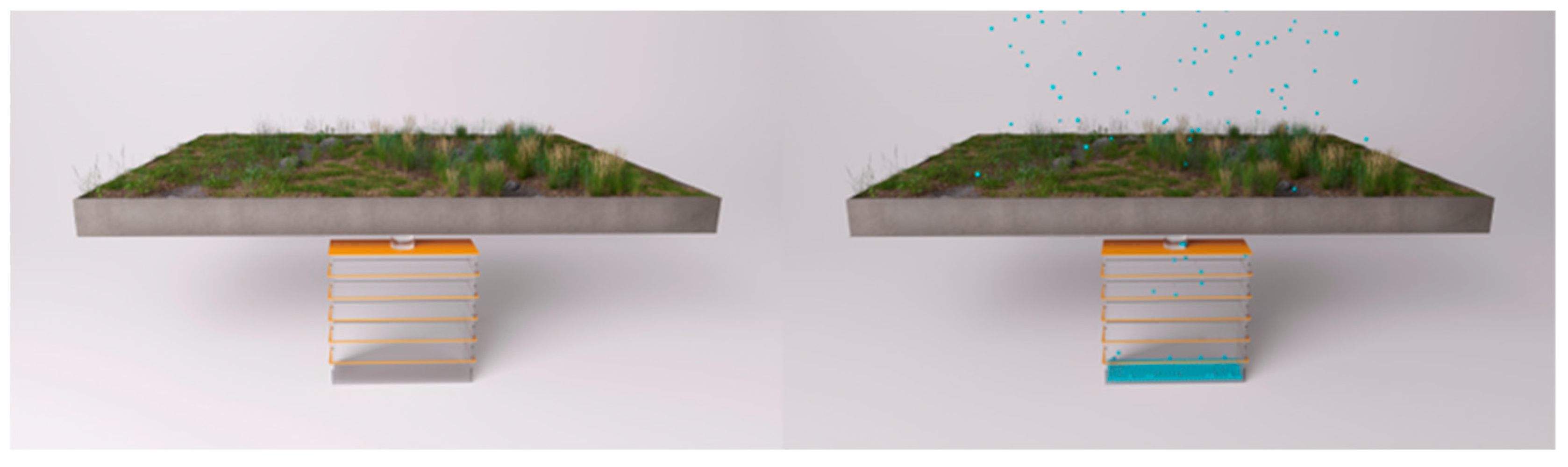

Table 1.
The results of the Google Scholar literature search.
| Search terms | Results |
|---|---|
| “drones smart and connected stormwater systems” | 6 290 |
| “drones for water measurement” | 61 800 |
| “drones monitoring plant health” | 36 900 |
| “drones surface imperviousness” | 6 120 |
| “drones land surface temperature” | 36 000 |
Table 2.
The results of the Scopus literature search.
| Search terms | Results |
|---|---|
| drones AND stormwater | 8 |
| drones AND water AND measurement | 347 |
| drones AND monitoring AND plant AND health | 71 |
| drones AND surface AND infiltration | 91 |
| drones AND land AND surface AND temperature | 45 |
1 Search term “imperviousness” provided zero results.
Table 2.
Description of the rain event used in the simulation.
| Number of the rain event |
Start (min: sec) |
End (min: sec) |
Amount of rain (mm/m2) |
Volume of total precipitation (ml) |
|---|---|---|---|---|
| 1 | 0:00 | 1:06 | 34,23 | 5 230 000 |
Disclaimer/Publisher’s Note: The statements, opinions and data contained in all publications are solely those of the individual author(s) and contributor(s) and not of MDPI and/or the editor(s). MDPI and/or the editor(s) disclaim responsibility for any injury to people or property resulting from any ideas, methods, instructions or products referred to in the content. |
© 2023 by the authors. Licensee MDPI, Basel, Switzerland. This article is an open access article distributed under the terms and conditions of the Creative Commons Attribution (CC BY) license (http://creativecommons.org/licenses/by/4.0/).
Copyright: This open access article is published under a Creative Commons CC BY 4.0 license, which permit the free download, distribution, and reuse, provided that the author and preprint are cited in any reuse.


