Submitted:
08 September 2023
Posted:
11 September 2023
You are already at the latest version
Abstract
We analysed changes in magnitude and timing of the largest annual observed daily flow (Amax), in each water year, for 596 stations in high-value water resources catchments and flood risk locations across Australia. These stations are either included in the Bureau of Meteorology's Hydrologic Reference Stations, or used in its operational flood forecasting services. Monotonic trend (which are either consistently increasing or decreasing) analyses of the magnitude and timing of flood peaks (estimated using Amax) were performed using Theil-Sen and Mann-Kendell approach and circular statistics to identify strength of seasonality and timing. Regional significance at the drainage division scale was analysed using the Walker test. Monotonic decreasing trends in Amax flood magnitude were detected in the Murray-Darling River basin and in other drainage divisions in Victoria, south-west and mid-west of Western Australia and South Australia. No significant obvious pattern in Amax magnitude was detected in northern Queensland, coastal NSW, central Australia and Tasmania. Only the Tanami-Timor Sea Coast drainage division in northern Australia showed monotonic increasing trends. Monotonic trends in Amax magnitude were regionally significant at the drainage division scale. We found two distinct patterns in flood seasonality and timing. In the northern and southern parts of Australia, flood peaks generally occur during February to March and August to October, respectively. The strength of this seasonality varies across the country. Weaker seasonality was detected for locations in the Murray-Daring River basin, and stronger seasonality was evident in northern Australia, south-west of Western Australia, South Australia, Victoria and Tasmania. The trends of seasonality and timing reveal that in general, flood peaks are occurring later in the water year in recent years. In northern Australia, flood peaks are generally occurring earlier – at a rate of 12 days/decade. In Victoria, New South Wales and Tasmania, trends in timing are generally mixed. However, in the south-west of Western Australia, the largest change in timing was evident – with Amax peaks commencing later at a rate of 15 days/decade. Decadal variability in flood timing was found at the drainage division scale as well. Most stations show a decreasing trend in Amax magnitude, but how that trend is associated with the change in timing is not clear.
Keywords:
flood peaks
; seasonality and timing
; monotonic trends
; annual maxima
; Mann-Kendell tests
; walker test
; Australia
1. Introduction
Globally, flooding is the most common natural disaster and is the deadliest natural hazard after earthquake and tsunami [1]. During 1980-2009, floods led to over half a million deaths, and affected 2.8 billion people across the world [2]. Approximately 196 million people in 90 countries have been exposed to flood related damages [3]. Such damages are projected to rise due to continued economic growth, prosperity and climate change. While economic loss resulting from flooding has increased over the past 50 years, the World Meteorological Organization (WMO) reveals that improved monitoring and forecasting of floods and related hazards has led to a significant declined in mortality. Since 2000, more than 94 million people are affected worldwide by flood and related issues every year [4].
Global warming due to climate change has been attributed to the increase in floods and related risks, as a warming climate has potential to influence hydrological cycling at the global and continental scale [5,6]. The IPCC [7] reported that human activities have resulted in approximately one degree Celsius of global warming above the pre-industrial level and will likely reach 1.5 degree Celsius between 2030 to 2052(at the current rate). Rising temperatures can potentially intensify extreme weather and rainfall events [6,8]. With an increase in the number and magnitude of extreme rainfall events, there is a greater risk of floods and higher peak flows [7].
Study of flood magnitude, frequency, duration, timing, is important for design, operation, and management of hydraulic structures [9]. In particular, flood magnitude and frequency [10,11] are fundamental for the design and operation of flood defence systems, irrigation water management systems and hydroelectric systems [12]. Accurate prediction of the timing and magnitude of flood peaks is important in floodplain management and operation of water infrastructure [13,14,15,16]. Understanding the timing and magnitude of flood peaks bring additional dimensions in water resources management, assessment of flood risk, impact of climate change and its regional implications [17,18,19,20,21]. Together, these studies are very important to help reduce the physical and economical vulnerability of human societies to flooding.
Many studies have examined global-scale trends in streamflow, flood magnitude and seasonality. Increasing trends in annual maximum daily streamflow happen mostly in central North America, southern Brazil and the northern part of western Europe, while decreasing trends often happen in Asia, Australia, the Mediterranean, the western and north-eastern United States, and in northern Brazil, [22,23]. Gudmundsson et al. [24], after analysing streamflow data from over 30,000 gauges worldwide, found that the direction of any trends is generally consistent for high, moderate and low flows for a given region. Across the world, analyses of floods and extreme streamflow events show little to indicate that increases in high rainfall events lead to similar increases in high streamflow events [25]. However, changes in timing of flood peaks, which we approximate as the annual daily maximum flow (Amax), were consistent with changes in rainfall [26]. Lee et al. [27] studied high-flow seasons using temporal streamflow patterns at the global-scale and found that 40% of locations have identical highest flow months and 81% are within a month. In comparison, only a small number of locations with high-flow seasons show bimodal flow regimes.
Bloshcl et al. [28] analysed the timing of flood peaks in Europe over the past 50 years using data from 4,262 streamflow stations, and found clear patterns of change in flood timing – with higher temperatures leading to earlier spring snowmelt floods throughout north-eastern Europe, and delayed winter storms leading to later winter floods around the North Sea and some sections along the Mediterranean coast. Parajka et al. [29] found similar results – where annual daily streamflow maxima generally occurred between July and August in the northern Alps, with a shift later in the year for southern Austria and north-east Italy. Macdonald and Sangster [30] examined flood seasonality for a river in northern England since 1750, and noticed an increase in February-March flood event peaks since 1950. While studying annual maximum streamflow for 189 catchments in Switzerland, Köplin et al. [31] identified the largest change in flood seasonality in catchments where snowmelt played an important role.
Dhakal and Palmer [32] developed a comprehensive circular statistical method to assess seasonality of flood magnitude and timing in the North-eastern and Upper Midwest United States. Their results showed temporal change in seasonality – the distribution of flood timing was strongly unimodal for most stations between 1951–1980, yet the seasonal modes weakened between 1981–2010., Villarini [33] concluded that flood timing across the continental United States can be approximated by a circular symmetric distribution for most stations, and that changes in timing and magnitude are strongly preconditioned by catchments’ long-term wetness and ability to store water [34]. Similar results were also found from cluster analysis of data from 806 gauging stations in the south-eastern United States [35]. A study using circular statistics to examine the seasonality of annual maximum floods and changes over time across contiguous United States [36] found that catchments with more synchronised seasonal water and energy cycles largely inherit stronger seasonality, while those catchments with loosely synchronised water and energy cycles are influenced more by high antecedent soil moisture storage. This effectively explains a statistically significant change of flood seasonality in recent decades for some catchments.
Globally, floods are most common in Canada, and the costliest natural disasters threatening lives, properties, infrastructure, economy and environment [37]. Burn [38] analysed the seasonal nature of flooding across 59 natural catchments, and resulting implications for regional flood frequency analysis. Many studies have investigated the temporal variation of flood timing, frequency and magnitude [39], and trends in magnitude and spatial variation [13,40]. More recently, Mostofi Zadeh et al. [41] using data from the Canadian Hydrometric Reference Stations, investigated trends in flood magnitude and frequency ,and their regional significance These authors examined changes using different groups of locations based on principal hydro-climatic region, drainage area, and land-use change .
Australia is a land of extremes – with flood, drought and wildfire. Significant floods occur in different hydroclimatic regions of Australia almost every year. Floods are natural phenomena that can provide benefits to the environment. However, floods are also natural disasters that may lead to mortality and extensive damage to property and infrastructure. The most recent catastrophic floods, in economic terms, affected eastern Australia in 2010-11 and in 2022, when a series of rainfall events, coupled high soil moisture, caused multiple flood events in New South Wales, Queensland and Victoria. The 2010-11 floods affected over 100 cities, towns and communities across all these states. In 2010-11, about four-fifths of Queensland (a state jurisdiction of 1.85 million square kilometres) was declared a disaster zone, thirty-five people were killed, and damages were estimated at about $5 billion [42]. Recent climate change attribution studies demonstrate links between changes in extreme rainfall in Australia and climate change. Warming in sea surface temperatures to the north of Australia may have contributed, by up to 20%, to the extreme rainfall of 2010-11 in eastern Australia [43]. However, conclusions drawn from independent attribution studies differ across different hydroclimatic regions and also magnitude of extreme rainfall [44]. Effects of a warming climate on the hydrologic cycle is projected to change the magnitude, frequency, and timing of riverine flooding. Trend analysis of annual maximum flood from 491 stations across Australia [45] showed about 30% of stations with significant downward and upward trends in southern and northern Australia. . In a review of trends and variability in Australian flood events , Johnson et al. [46] found it difficult to link trends in rainfall with trends in flood magnitude due to influences of other factors such as temperature and evapotranspiration. Wasko and Nathan [47] and Sharma et al. [48] drew similar conclusions ; that trends in rainfall and soil moisture did not always describe the observed trends in flooding in Australian rivers. However, these studies had limited spatial or temporal coverage of streamflow data to draw conclusions at the continental scale. Furthermore, there were almost no comprehensive studies in the seasonality of flood, changes over time and spatial interpretation across different hydroclimatic regions.
1.1. Objectives and scientific questions
A comprehensive analysis of the seasonality of flood and trends in magnitude over time across Australia requires further investigation. Therefore, we selected 596 streamflow gauging stations to address the following research questions:
- What is the seasonality of flood events across Australia? Our analyses focus on basic seasonality, its time of occurrence after rainfall, and spatial distribution across drainage divisions covering different hydroclimatic regions.
- Can we detect changes in the seasonal cycle of flood occurrence over the past 50 years?
- Are there any monotonic trends in flood magnitude across Australia over the past 50 years? (A monotonic trend is one that is either a constantly increasing or decreasing).
- Are the changes in seasonality and flood magnitude with time statistically significant at the regional scale across Australia?
2. Catchments Data and Methodology
2.1. Catchments and Data
There are 467 streamflow gauging stations in the Hydrologic Reference Stations (HRS) service across Australia [49]. These stations provide long-term, high quality daily streamflow data which can be used to detect long-term variability and trends in streamflow. The Australian Bureau of Meteorology provides quantitative flood forecasts at a number of defined locations [50]. Of these locations, 26 are in the HRS, and a further 129 are upstream of managed river basins, irrigation return flow diversions, which can be used to examine changes in flood events. This study analysed data from a total of 596 stations. The distribution of these stations across twelve drainage divisions varies substantially – with the Murray Darling Basin has the largest number of stations, whereas the South-Western Plateau has none (Figure 1). The longest streamflow record begins from the 1950s, and the shortest one from the 1980s (Figure 2). For a particular gauging station, we consider the whole period of data for our analyses and interpretation. Gauging stations with longer records are generally located in water resource catchments and populated areas along the coastal regions (Figure 1). Catchment area also varies across different hydroclimatic regions, drainage divisions and the country. The catchment area ranges from 4.5 km2 to 906,000 km2.
Australia has a wide range of climate zones. It ranges from the tropical regions of the north through the arid expanses of the interior, to the temperate regions of the south (Figure 1), as defined by Köppen Climate Classification [51]. The Australian hydrological geospatial fabric (Geofabric) originally defined 12 topographically distinct drainage divisions across Australia [52]. However, the South-East Coast division is now split into two, totalling 13 (Table 1) drainage divisions (http://www.bom.gov.au/water/about/riverBasinAuxNav.shtml, accessed 11th May 2023). Lake Eyre Basin is an internally draining division. Gauging stations were selected to capture the maximum geographical coverage, length of available record, and to cover all climatic zones, jurisdictions, and drainage divisions across Australia. Mean annual rainfall (1950-2018) for a division varies from approximately 200 to 1300 mm. Except the Tasmanian division, mean annual PET is generally higher than mean annual rainfall [49]. Streamflow generation processes in most divisions are controlled by water-limited environments [53]. Figure 2 shows the number of streamflow gauging station in each of the jurisdictions and the length of record. The Murray-Darling Basin (MDB) has the largest number of stations while the North Western Plateau (NWP) division has the lowest. The South Western Plateau (SWP) division as no suitable locations. Of all the selected station, 44 have the longest period of record beginning in 1950.
2.2. Analytical Methodology
In this section we address two questions – (i) are there monotonic trends in flood peak across Australia (represented by Amax), and (ii) what is the seasonality of Amax (daily maximum flow within a year) and how have those changed across Australia? The analytical methodology to answer these two questions are shown in conceptual Figure 3 and detailed in the following sections. We use Theil-Sen (Theil, 1950; Sen, 1968) and Mann Kendall approach [54,55] to detect trends in flood magnitude and timing, circular statistics to investigate timing of Amax , and Walker test [56] to identify regional significance.
2.3. Identifying flood thresholds and timings
Flood magnitude and risks are closely associated with the return period and recurrence intervals. There are two approaches generally used to determine flood event thresholds: (i) the Annual maximum daily streamflow (Amax) time series and (ii) the Peak Over Threshold (POT). Advantages and disadvantages of using these two series have been discussed by Mostofi Zadeh et al. [57]. Amax series have been extensively used for flood analyses. However, this series does not represent complexity in the flood regime [58], as it represents only the largest single flow in each year, and therefore excludes large floods if several occur in a given year. This is a limitation as it can result in loss of valuable flood-related information [59,60,61]. Another shortcoming of Amax series is the potential inclusion of some very low flows during low annual flows [60], which may potentially alter the outcome of the extreme value analysis [62]. However, Amax series are relatively easy and practical to acquire and the most commonly available form of data.
Choosing POT time series is an alternative to Amax. The POT series avoids Amax shortcomings as it considers flood peaks above a specified threshold, and allows capturing more information about flood peaks [63]. Relatively high flood peaks that are not included in the Amax series will be considered in the POT series if they fall in the same year. A major difficulty of using POT series, and one that requires additional analytical complexity is the need to define an appropriate threshold and determine independence of the data series[60]. These complexities make the POT time series relatively unpopular and therefore not widely used in flood frequency analyses and design flood estimates [64].
While Australia receives only 475 mm/year of rainfall on average, this is highly variable in both space and time [65]. Its unique topographic and geological features together with rainfall distribution, result in large interannual variability in streamflow [66,67] and floods. Within-year distribution of rainfall and streamflow varies across the continent. The Australian Bureau of Meteorology provides quantitative flood forecasts for many locations as part of ongoing fulfilment of Water Act 2007 and Meteorology Act 1955 (Bureau of Meteorology: http://www.bom.gov.au/australia/flood/knowledge-centre/, accessed 20/03/2023). Operational flood forecasting thresholds for river height (minor, moderate and major) are location specific and are defined in Service Level Specification documentation between the Bureau and other stakeholders [50]. In this study, we use Amax time series for our analyses and interpretation, as this annual series could be considered independent. It does not represent Bureau’s operational flood forecasting thresholds. Our analyses are based on the Water Year as described in Section 3.2.1. All Amax data included in this study are compiled, quality checked and made consistent across the country.
2.4. Monotonic Trend and Change Analyses – Amax
We applied Theil Sen’s non-parametric method [68,69] to detect the magnitude of linear trend for Amax time series. We also determined trends by using the Mann–Kendall (MK) test [54,55] which is robust against outliers, distribution-free, and has a higher power for non-normally distributed data [70,71]. In many streamflow trend analyses, this method has been used [72,73,74]. The Mann–Kendall test could only be applied to serially uncorrelated input data. Otherwise for the data structure with serial correlation, it may result in overestimation of the significance of trends [70,75]. To overcome this issue with serial correlation, we used two modified MK tests: (i) the variance correction (MK3) method, and (ii) a Block Bootstrap (MK3bs) method [76]. The MK3bs approach is more suitable when the time series show higher order serial dependencies. Finally, the Walker test was used for testing for the regional significance of any monotonic trends [56]. A similar procedure for detecting seasonal and annual total streamflow trends was followed by Amirthanathan et al. [49]. Details of different Mann-Kendall tests are provided in several articles [58, 72,77].
2.5. Shifts in seasonality and timing
Due to changes in hydrometeorological and flow generation processes, distribution of timing and seasonality of flood magnitudes are diverse and are shifting across Australia. Therefore, the seasonality of flood peaks characteristics cannot be described by traditional statistical methods. Circular statistics are generally used to investigate changes in flood timing and seasonality, and date back to the early-twentieth century [86]. Circular statistics were first used by Burn [38] to identify seasonality of the annual maximum daily rainfall and streamflow in Canadian rivers. Since then, this approach has been applied by others [79] and has been shown to perform well to analyse complex seasonal variations [13,31,33,80]. One major advantage of circular statistics instead of linear statistics on the seasonality and timing of flood events is that a circular random process provides greater understanding of the timing of flood events. Most of these studies have used two statistics for analysis of timing and seasonality of flood events. However, for catchments with multimodal seasonality patterns instead of unimodal, information from two summary statistics could be insufficient [80]. The mean timing of flood occurrence may not reflect potential shifts in flood generation process in a changing climate or with changes in land use. Few studies have attempted to address these limitations by using circular uniform, reflective symmetric and asymmetric distributions [33] or circular mixture distribution [81].
The applicability of most trend tests in circular statistics requires testing nonuniform distribution of the variable under consideration [28,80]. Three well known non-parametric uniformity tests - Kuiper’s test, Rao Spacing Test, Rayleigh Test [82,83] are widely used for testing the null hypothesis being the uniform distribution. For nonuniform distribution of flood timing, a trend analysis can be performed – using circular-linear associations [33], circular regression [26], or non-parametric techniques such as the Mann-Kendall trend test [84] or Theil-Sen slope estimator [28,85].
2.5.1. Circular statistics
The period defined by the Water Year (detailed in Section 3.2.1) varies across the continent. The first month of the water year begins with the lowest monthly flow or first month of the year when flow commences. To ensure a sequence of independent flood events, Amax is not counted in two successive years [86], and the flood and centre of timing can be adjusted based on the start of the water year. We count Julian day from the beginning of the water year. For each of the stations, we calculate the average day within a year on which floods have occurred during the whole period of record. As floods can occur throughout the water year, we perform all calculations using circular statistics.
We perform statistical tests of circular uniformity and use only those stations for which the null hypothesis was rejected at a significance level of . We performed Rayleigh Test, one of the three well known non-parametric uniformity tests - Kuiper’s test, Rao Spacing Test, [92], and retain only the stations where the null hypothesis was rejected. This uniformity test was applied to 596 stations for the analysis of the average timing. Circular non-uniformity is necessary for a meaningful application of circular trend analysis.
Circular statistics are often applied when investigating flood peaks and timing, as these exist on a cyclical continuum. To apply circular statistics for each of the stations within a drainage division, the Julian day () of the calendar to be converted to an angular value () where is the number of days in the Julian year and is the number of years.
The mean direction or mean timing, in radians can be calculated as [82]:
In the above equation
2.5.2. Linear statistics
When a circular variable does not extend around the circle, it can be linearised and analysed based on normality [87]. We adjust the number of days for each of the stations (within a drainage division) since the first day of the first month of the water year as standardised Julian day ()
In the above equation, is the number of days from the first day of the calendar year to the first day of the water year and is the number of days in a year (365.25). The mean flood seasonality of a station in a drainage division is calculated as:
The calendar day of the seasonality of flood peak can be obtained through reversing of the Eq. 4. The concentration of the day of occurrence around the mean flood seasonality date is calculated as:
where the value of ranges from 0 (flood peaks widely spread throughout the year) and 1 (all flood peaks occur on the same day of the year). We define the time of concentration (). Larger values indicate smaller variability in the timing of Amax, therefore stronger seasonality. The Amax flood events are more likely to occur in a particular window of time every year at locations with large values. For gauge locations with small values, the occurrence of Amax events scatter across the year, and the mean date is less representative of the actual occurrence date of the Amax events.
2.5.3. Estimating trends
We estimated the trend in timing by using Theil-Sen slope estimator [68,69] . The trend estimator is the median of the difference of adjusted Julian days over the possible number of years ():
We estimated the long-term changes in flood timing with a 10-year central moving average filter to minimise year-to year variability and focus on decadal fluctuations and trends in timings.
We also estimated the long-term changes in flood timing within a drainage division with a 10-year centrally moving average filter using Eq. 5 to reduce the year-to year variability and focus on decadal fluctuations. For each drainage division, the mean, median and standard deviation of timing for all stations () in standardised Julian days for each water year can be calculate as:
A 10-year moving average filter was then applied to the annual median timing to obtain the longer-term changes within each of the drainage divisions. We used standard deviation as a measure of the spread within the year across all stations in a drainage division. We calculated all circular statistics in standardised Julian days and present it in calendar year/days through reverse calculation of Eq. 4.
2.6. Test for regional significance
If significant trends are detected at a location, it is sensible to also assess regional significance at the drainage division scale, and to determine whether similar trends are also observed at neighbouring locations [58,88,89]. The main objective is to assess at the regional scale whether the number of locations with significant trends occur or not. We define regional scale by the drainage divisions detailed in Table 1 (Figure 1). The Walker Test [56,90] was applied to detect regional significance of Amax and seasonality timing. This test was successfully applied to annual and seasonal streamflow totals to detect field significance at regional scale across Australia and therefore not repeated here [49].
3. Results
We extracted the annual flood magnitude (Amax) and timing and completed analyses based on the hydrological water year. The beginning of water year varies significantly across the country (detailed in Section 3.2.1). We completed all the trend analyses and determined its regional significance based on the water year.
3.1. Trends in Amax magnitude
We estimated trend slopes of data for the 596 stations by Theil-Sen’s approach for Amax across Australia. Median of slopes for Amax for significant statistical trends were less than zero (negative slope) for most drainage divisions Figure 4). Only a few drainage divisions in northern Australia showed positive trends. For Amax, the median of slopes was approximately -0.61 mm/day/decade. An example of linear trend analysis using Theil Sen’s approach – for a site in Duck River (-0.7 mm/day/decade) in Tasmania and Finniss River (+3.8 mm/day/decade) in Tanami-Timor Sea Coast drainage divisions is shown in Figure 5.
We summarise the MK1, MK3 and MK3bs test results in Table 1 and spatial distribution of trends for each drainage division are shown in Figure 6. In general, almost the same stations in each drainage division show significant trends for the MK3 and MK3bs methods. Overall, 191 stations across Australia showed a significant decreasing trend (MK1). Results from other two tests were similar in terms of the proportion of locations with negative trends (Table 1). Most decreasing Amax trends were for sites within the SEV, TAS, MDB, SAG, and SWC drainage divisions. About 45% and 40% of stations in the MDB and SEV showed significant decreasing trend, respectively. No significant decreasing trend was detected in TTS, CC, LEB NWP. Most stations in other divisions showed no significant trend (Figure 6). A statistically significant maximum decrease of 0.72 mm/year was found at one station in the SEN.
Of 596 Amax stations, across Australia, only 20 stations showed increasing trends (MK1) that were statistically significant (Table 1). While increasing trend results from the MK3 and MK3bs tests are very similar for most of the drainage divisions, the station numbers are generally less than that of Mk1. About 30% of stations in the TTS and CC drainage division depicted significant increasing trends. There were no stations in these to drainage divisions found to have significant decreasing trend (Table 1). There are only a few stations in the MDB, SEN, SEV, SAG and PG that showed significant increasing trends. No stations in TTAS, SWC, LEB or NWP showed statistically significant trends. The magnitude of Amax increasing trends also varied from one station to another – the largest significant trend 1.56 mm/year was detected at as station in the SEN.
The spatial distribution of Amax trends across Australia under all three MK tests reveals very interesting results (Figure 6). In the northern part of Australia, significant increasing trend was common, while there were nearly no stations with a decreasing trend. There is no obvious pattern of trend in central Australia. In Victoria and New South Wales, decreasing trends were detected for more than 50% of stations, while only a few stations showed an increasing trend. In Tasmania and south-west of Western Australia, only the decreasing trend in Amax was prevalent, with no stations showing an increasing trend (Figure 6).
3.2. Trends and timing of flood peaks
Mean timing of Amax peaks is calculated using the Julian day of the water year and presented in the calendar year and trends are calculated using Theil-Sen approach as detailed in Section 2.5.
3.2.1. Water Year
In this study, the water year is defined according to the Hydrologic Reference Stations ’Glossary’ (http://www.bom.gov.au/water/hrs/glossary.shtml). For stations with non-zero or zero monthly streamflow, the water year begins with the month recording minimum average monthly, or first month with average non-zero flow over the period of data. If the first month is between January and June, the water year is assigned the same as the calendar year of the beginning month. For starting months between July and December, the water year is assigned the year following the calendar year of the first month. We further refine this approach by averaging the beginning months of all stations within a given drainage division.
The first month of water year varies across the continent. In the central, mid-west and northern regions of Australia (drainage divisions PG, NWP, TTS, LEB, CC) the water year begins in September, while in the north-east coast (drainage divisions NEC and SEN) it begins in October (Figure 7a). The water year begins nearly six months earlier in the southern regions of Australia – February for drainage divisions MDB, SEV, SWC and SAG and March for drainage division TAS, respectively. We undertook trend analysis for Amax and timing based on the respective water year of each of the drainage divisions, as the assumption of a single water year over large continental Australia is not adequate.
3.2.2. Test for Circular Uniformity
As indicated in Section 2.5.1, we performed Rayleigh Test for circular uniformity with null hypothesis that the distribution is uniform at a significance level of p=0.1. That means if the null is rejected (not significant) the distribution cannot be assumed to be uniform. This resulted in 592 stations out of 596 for the meaningful application of circular trend analyses (Figure 7b), and that these stations have clear non-uniform Amax streamflow distributions within a year. The remaining four stations, where the test was significant, and where there is no clear annual streamflow distribution, are located in drainage divisions SEN, MDB, TAS and TTS respectively.
3.2.3. Timing of Amax peaks
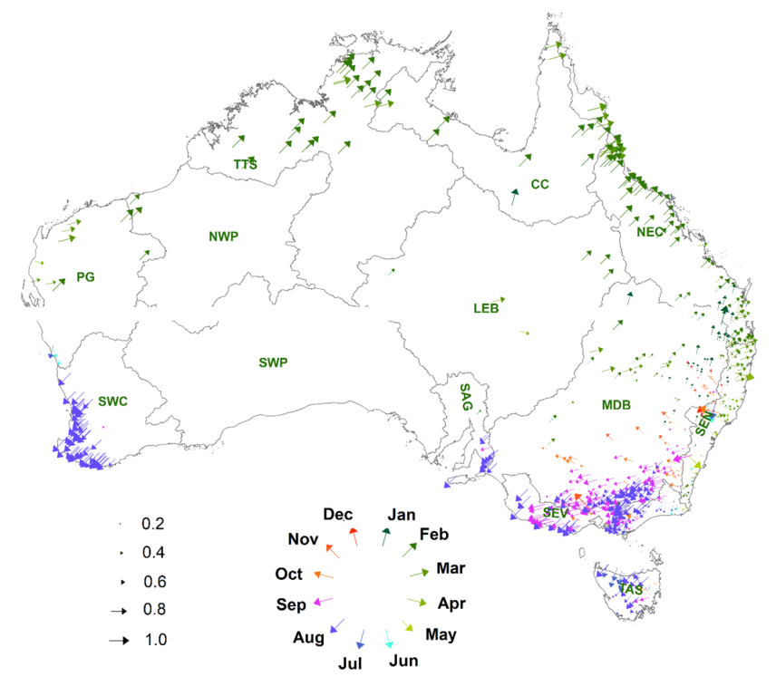
The timing of Amax peaks across Australia has two distinct clusters – February to April and August to October, respectively (Figure 8). Almost no Amax occurs across the country during the periods of November-January and May-July. The spatial nature of flood seasonality and timing across Australia is very interesting (Figure 9). In drainage divisions NEC, CC, LEB, TTS, NWP, SEN and PG, Amax peaks occur in February-March at 190 locations (or 33% of all stations). There is an abrupt change in seasonality when moving from north to south. About 55% of stations (330 out of 596) show Amax peaks in August-September (Figure 8). Most of these stations are in the drainage divisions SEV, TAS SAG, and SWC. The MDB is the only division where Amax peaks are generally observed in February-March in the north-western region and August-October in the south-western region. There is no clear pattern of Amax timing in central Australia.
The strength of seasonality (R) and timing of Amax also varies across the country (Figure 9). The norther part of Australia (north of Western Australia, Northern Territory and northern Queensland) generally exhibits strong seasonality (). Similarly strong seasonality is also observed in south-west of Western Australia, Tasmania and Victoria. However, in the MDB and SEN, Amax seasonality is weakest. There are also two distinct patterns of timing of Amax peaks in the MDB as well – February and September for the northern and southern part of the basin, respectively (Figure 9).
3.2.4. Trends in timing
Similar to the Amax flood magnitude, we estimated trends of seasonality and timing of 596 stations by Theil-Sen’s approach. The median of slopes was slightly above zero (Figure 4b) indicating that across Australia, Amax peaks generally occur later in recent years for most stations. Range of increasing or decreasing of timing at 95th percentile level of significance varied from -19 days/decade to +17 days/decade. Only 65 stations showed statistically significant (p=0.10) trends – 31 decreasing (where Amax peaks start earlier) and 34 increasing (Amax peaks start later) across Australia (Table 1). The TTS and SEV drainage divisions had significant decreasing trends, while the SWC drainage division showed a significant increasing trend. There were only few stations in the MDB, SEC and TAS that showed either a increasing or decreasing trend. No stations in NEC, SAG, CC, or SWP showed statistically significant trends (Table 1). The magnitude of Amax timing trend also varied from one station to another – the largest significant trend +29.96 days/decade was detected at as station in the Murray Darling drainage division.
The spatial pattern of trends in timing and seasonality of Amax across Australia is shown in Figure 10. In the northern part of Australia, Amax peaks generally earlier – approximately -10 days/decade, which translates to 50 days shift over the last 50 years. In Victoria and New South Wales and Tasmania, trends in timing are generally mixed – with an overall slight increasing trend of approximately +4 days/decade. In the SWC drainage division in Western Australia, the largest decrease of approximately -10 days/decade was evident (Figure 10b).
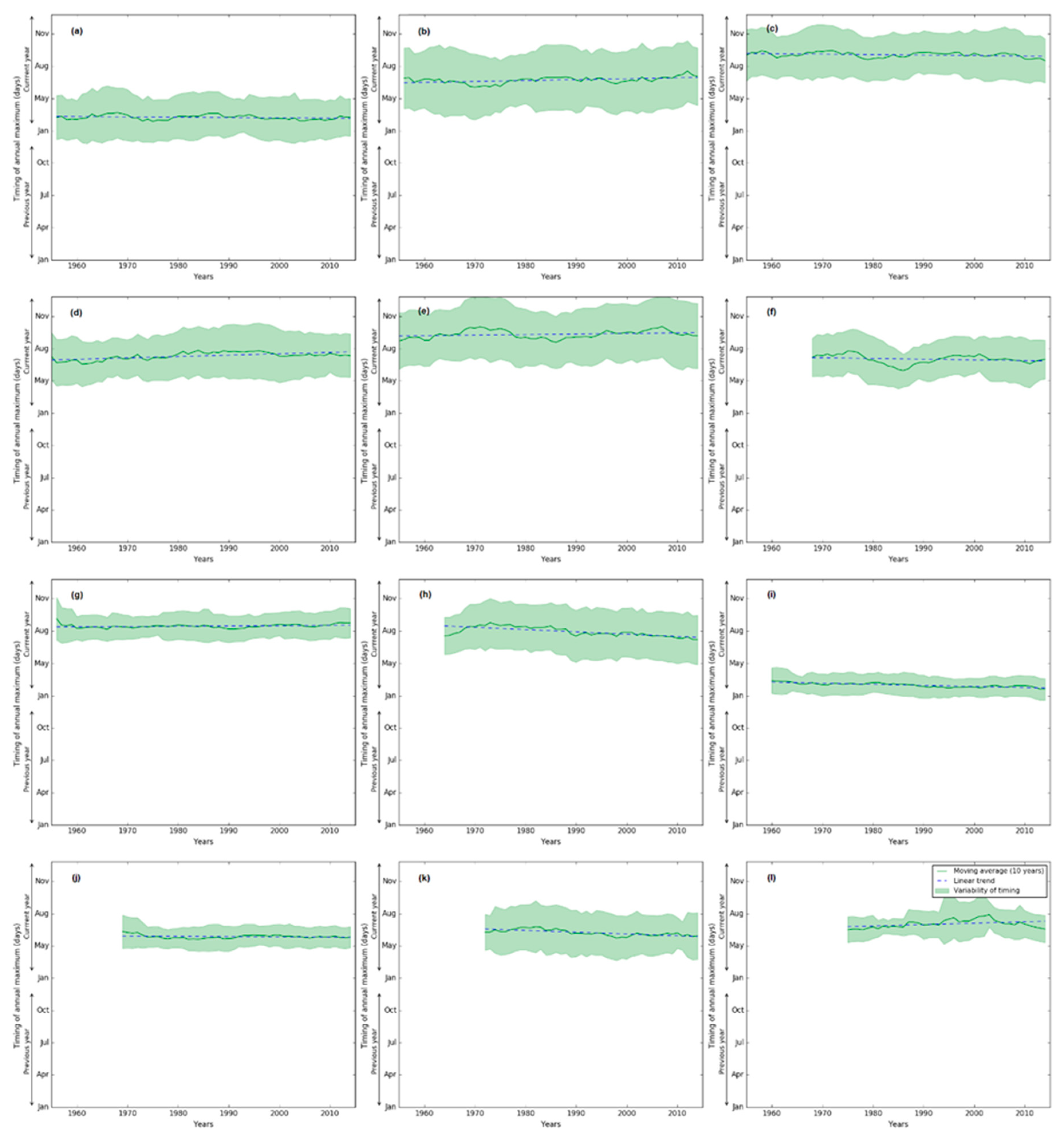
To further examine regional trends of Amax magnitude, timing and seasonality, we focused on each of the drainage divisions. The 10-year rolling centrally averaged timing of Amax reveals interesting facts. There are decadal fluctuations of Amax characteristics for most of the drainage divisions (Figure A1). Variability of Amax timing in a given year within a drainage division depends on the strength of the seasonality (Figure 9) and timing of Amax of stations within that drainage division. Typical examples of these are shown in Figure 11. In the NEC drainage division, there is no significant trend in timing for any individual stations, which is collectively evident in the basin-scale as well (Figure 11a). In MDB, the strength of seasonality is weak (Figure 9), which resulted in a higher variability of timing within the year and no apparent trend in timing at the division scale (Figure 11b). We found that a greater proportion of stations in the SWC and the TTS drainage divisions show stronger seasonality, with increasing and decreasing trends in timing, respectively (Table 1, Figure 9, Figure 10), and is clear at the division-scale as well (Figure 11c,d).
3.2.5. Trends in magnitude
Figure 12 presents the scatter plot of changes of trends in timing and changes of the magnitude of Amax for all stations where these were statistically significant (n=30). Most stations show decreasing trend in Amax magnitude, but how that tendency could be associated with the change in timing is not clear. However, more stations with decreasing trend in Amax magnitude tend to associate with decreasing trend of timing of Amax. Greater insights into the individual drainage division further supports this observation.
3.3. Regional Significance
We performed Walker test [56] to determine regional significance at the drainage division-scale of magnitude and changes and timing of Amax peaks. Regional significance of trends and step changes in annual and seasonal streamflow at drainage division regional scale using Walker test been previously been completed and published [49].
3.3.1. Amax magnitude, seasonality and timing
Table 2 summarises regional significance at the drainage division-scale of the monotonic trends of Amax magnitude and timing. It is interesting to see that regional significance is consistent for the three different Mk tests for most drainage divisions. Trends in Amax magnitude are regionally significant for drainage divisions SEN, SEV, MDB, SAG, SWC, PG, TTS and LEB. However, trends in timing of the Amax peaks are only significant in the TAS and TTS drainage divisions. Spatial representation of these significances is shown in Figs. 8, 11 and 12 respectively.
4. Discussion
4.1. Consistency and enrichment
We present a comprehensive analyses of Amax flood magnitude trend, strength of seasonality, and changes in timing at 596 stations, located within different hydro-climatic regions (Figure 1) across Australia. Amax magnitude analyses had previously been researched [45,91,92]. Annual and seasonal streamflow totals were analysed more recently for 467 gauging stations [49]. The mean flood seasonality and changes in timing focusing on Australian continent with a smaller data set or global studies have recently been completed [26,93]. Our findings are consistent with those studies, but also provides: (i) a more comprehensive analyses and interpretation using longer data sets (596 stations, 1950 to 2022), (ii) analysis of regional significance at the drainage division scale, and (iii) evidence of decadal variability of flood seasonality. Our study provides further insights into how flood magnitudes have changed over time – increased and decreased in northern Australia and southern Australia respectively.
4.2. Statistical tests
There are many statistical tests suitable to assess significance of a change in a given time series [76]. However, the MK tests [54,55] are widely used as rank-based nonparametric tests to detect slowly varying (monotonic) changes in the mean or median of a time series, and in particular those of rainfall and streamflow [16,49,90,94,95,96,97,98,99,100]. These tests are popular due to (i) simplicity for implementation, (ii) robustness against outliers or measurement errors, and (iii) availability of test statistics under a null hypothesis. In this research, we used three forms of MK tests (Mk1, Mk3 and Mk3bs) to identify monotonic trends in Amax magnitude, and Mk1 for changes in Amax timing. These have been widely used for this purpose [72,73,74,101].
We used the mean and variability to analyse shifts in timing and strength of seasonality of Amax flood events (Figs. 11, 12). We have not tested if any of the 596 stations have a multimodal or unimodal seasonality pattern. For catchments with multimodal seasonality patterns, the application of two summary statistics we have used here could be insufficient. This could be overcome by using circular uniform, reflective symmetric and asymmetric distributions [33] or circular mixture distribution [81].
4.3. Flood peak generation, rainfall and climate change
In Australia, the mean flood timing corresponds to the rainfall seasonality. A comprehensive review of rainfall variability, extremes, trends and attribution across Australia was completed by Dey et al. [65]. Rainfall extremes are generally increasing across Australia [98,102]. However, some studies, such as that by Jakob and Walland [103], do not confirm this and may be due to different data sets and procedures used. Observed records show that mean annual rainfall in northern regions of Australia has increased, while in the southwest and southeast of Australia, has a decrease since 1950s has occurred. Streamflow variables tend to mirror these same trends across Australia [16,49,91]. However, the Amax flood peak magnitude trends show universal increasing trends only in tropical regions in the north, with significant decreasing trends in the south of Australia (Figs. 8, 12). These findings add further evidence that traditional flood frequency analyses should be questioned.
The IPCC Sixth Assessment Report suggest that heavy rainfall events observed globally in recent years which resulted in catastrophic floods were more likely to occur more often with climate change [7]. The general consensus is that mean rainfall is likely to decrease in southwest Australia in a future warming world, but there is large uncertainty with regards to changes over northern and eastern Australia. However, there is high confidence that extreme rainfall increase in intensity and frequency [104,105]. This will have further implications on flood peaks and timing. A recent study [104,106] shows a projected decrease in flood event runoff coefficient across most of Australia due to climate change by the end of the century, with an exception for north-west Australia. This decrease in the proportion of flood runoff coefficient may be expected from large rainfall events, which may suggest decreased flood risk. However, it is possible that the projected reduction in runoff coefficient may be offset by projections of increased rainfall intensities associated with rising temperatures [102,107] due to increased atmospheric water holding capacity [108].
4.3.1. Northern Australia
Northern Australia covers drainage divisions TTS, CC and NEC (Figure 1, Table 1). This region receives substantial rainfall in the summer monsoon (December–February) as the north westerly winds bring wet moist air to form convective clouds. The summer rainfall has significantly increased since the 1950s [65]. The reason for this increase is not clear, and it could be due to (i) an increase in anthropogenic aerosols [109], (ii) warming of the tropical Atlantic Ocean [110], (iii) an increase in the frequency of tropical cyclones [111], and (iv) intensification of the Hadley circulation [104,112].
In northern Australia, the dominant mechanism for streamflow and flood processes is the infiltration excess [46]. The magnitude of the flood peak generally depends on the heavy rainfall event and status of antecedent catchment conditions, and in particular, the degree of wetness of the catchment [48]. Recent research [106,113] found a strong association of flood magnitude, antecedent soil moisture content and the amount of rainfall in that event. Our findings of increase in flood magnitude (Figure 6), stronger seasonality (Figure 9) and earlier commencement of flood peaks (Figure 10) are mainly attributed to the observed increase in annual rainfall. We have also observed decadal variability of changes of flood seasonality (Figure 11d) in northern parts of Australia, which warrant further investigation and research.
Due to climate change, the monsoonal extreme rainfall events and overall rainfall total in northern part of Australia is projected to increase [114]. However, the impact its impact on the frequency of extreme rainfall events is not clear [65]. If we assume that the other landscape processes, in particular evapotranspiration, will remain unchanged in future climate, the increase in total rainfall in this part of the continent may result in antecedent soil moisture increase which may ultimately result in larger increase in flood peaks during extreme rainfall events. A recent research supports this conjecture that flood runoff coefficient is projected to increase in northern Australia due to climate change [106].
4.3.2. Coastal NSW and Murray Darling Basin
This region covers the MDB and SEN (Figure 1, Table 1) drainage divisions. Observed rainfall in this region has been below average since the beginning of the 1990s until 2021 with the exception of above average rainfall for three years during 2010-12 and 2022. Changes in rainfall patterns could be attributed to the shifting of Subtropical Ridge and expansion of Hadley Cell due to greenhouse gas emissions [115,116]. Intense rainfall events in this region are generated due to low pressure systems off the southeast coast, particularly during the cool season (April to September).
Our study shows that Amax flood magnitude predominantly been decreasing in the MDB, and that this trend is regionally significant. However, only few stations in the neighbouring SEN division (to the east) showed any trend (Figs. 8,12, Table 1). Other streamflow variables (e.g. annual total, median flow or low flow) tend to exhibit similar pattern of trends in this region [16,49,91]. The strength of seasonality of Amax flood peaks is also weak in this region – February-March in the northeast to October in the south-west (Figure 9), and there is some evidence of shifts in timing (Figure 10). These could be attributed to: (i) saturation-excess being the dominant flood generation mechanism [117], and (ii) little association of flood peaks with the annual maximum rainfall [113]. The prolonged period of unprecedented below-average rainfall (excluding 2010-12 and 2022) may be another contributing factor in fundamental changes in flood generation process including declines in groundwater storage as well as reduced recharge and connection between subsurface and surface water processes [118]. Our assumption of unimodal distribution of seasonality pattern, instead of multimodal, could be another factor. The distribution of observed mean monthly streamflow in this region, as presented in the Hydrologic Reference Stations (BoM: http://www.bom.gov.au/water/hrs/#id=418015&panel=trend-explorer&pill=monthly&control-0_radios=volume&control-0=daily_max, accessed 09-01-2023) provides some indication of a multimodal distribution. A more advanced procedure could be applied to investigate further, including asymmetric distributions [33] or circular mixture distribution [81].
Future rainfall in this region is projected to decrease slightly (Bureau: https://awo.bom.gov.au/products/historical/precipitation/3.5,-26.623,149.198/nat,-25.609,134.362/r/y/2020 accessed 11-01-2023) or it may remain unchanged [65]. However, short-duration extreme rainfall is projected to increase [119]. Rootzone soil moisture content (in the top 1 m) is projected to decrease significantly, probably due to increases in potential evapotranspiration. As a result, flood runoff coefficients are most likely to decrease as well [106]. However, this impact on changes of timing of Amax flood peak (either earlier or later) is uncertain.
4.3.3. Southern Australia
This region covers the SEV, TAS, SAG and SWC drainage divisions (Figure 1, Table 1). A significant number of stations in drainage divisions show decreasing trends, and those are regionally significant (Table 1, Figure 6). The strength of seasonality is greater (for this region than for others) and there is a clear shift in timing, with flood peaks occurring later in the SWC drainage division, while for divisions, this is uncertain (Figure 9, Figure 10). Mean annual rainfall, intensity and frequency of extremes in this region has decreased significantly since the 1970s, and there is a phase shift in within-year distribution of rainfall [120,121], which is clearly reflected in timing of Amax flood peaks, which now occur later in the year. Streamflow in this region is predominantly generated by saturation-excess process mainly from the stream zone [122]. Reduction in rainfall has resulted in a lowering of groundwater, an increase in the unsaturated zone, disconnection of groundwater from the stream zone, and a large reduction in annual runoff and number of flood peaks [123]. Consensus is that the rainfall and frequency of extreme events are projected to decrease in future [65,102,124], with further reduction in flood runoff coefficient due to climate change [106,123].
In drainage divisions SEN, SEV, MDB, TAS and SAG, Dey et al. [65] detected significant reduction in extreme rainfall events over the period 1951-2021 and are projected to decrease further due to a southward shift and strengthening of the Subtropical Ridge [124]. Together with the reduction of mean annual and extreme rainfall, changes in landscape processes [118], flood peaks are likely to decrease under a future climate [106]. However, the effect on timing of flood peaks in these drainage divisions is uncertain.
In Tasmania, there is no trend in extreme rainfall since 1975 [65]. That may explain why only a few (about 6 out of 31) stations show a decreasing trend in Amax flood magnitude, but this it is not regionally significant (Figure 6). In a future climate, rainfalls over the coastal areas are projected to increase steadily with more frequent and intense events in most areas, except the central plateau, which may result in an increased flood peaks [125]. However, the overall effect of future climate change on mean runoff, flood peaks and timing remain uncertain – some earlier studies projected an increase in mean annual runoff [106,126] while more recent studies suggest a reduction in flood peak runoff is more likely (Bureau: https://awo.bom.gov.au/products/historical/precipitation/3.5,-26.623,149.198/nat,-25.609,134.362/r/y/2020 accessed 11th January, 2023).
4.4. Future research
Our analysis of trends in Amax flood magnitude, strength in seasonality and changes in timing of flood peaks across Australia provides insight into the changes in catchment flow generation processes, non-stationarity and the use of lumped rainfall-runoff models for operational streamflow and flood forecasting [127]. It may also help with parameter estimates of traditional initial and continuous loss models for design flood estimates, performing flood frequency analysis for flood protection planning and infrastructure design life estimates.
Research into actual flood events, rather than on the largest annual observed daily flow, would require additional work to identify common thresholds. But taking flood intensity and duration into account would provide even greater insight into changes in flood behaviour.
We have assumed there to be no anthropogenic changes in these catchments – in particular land use or landcover changes over the last 50 years, though these changes in Hydrologic Reference Stations catchments (Figure 1) are minimal [49]. In any future study, anthropogenic changes should be considered.
We used unimodal distribution to determine the strength of flood peak and seasonality. This may not be adequate for a few drainage divisions, in particular the MDB and SEN. These two divisions have very high economic, social and environmental significance for Australia. The use of a multimodal distribution may reveal further insight into the seasonality of Amax and flooding in these two drainage divisions.
We did not consider Amax data prior to the 1950s, which may be available for some of the catchments. In 2022, south-east of Australia (drainage divisions NEC, SEN, SEV, MDB, TAS and SAG) experienced unprecedented above average rainfall and flooding due to the influence of La Niña (Bureau: http://www.bom.gov.au/climate/enso/outlook/ accessed 11-01-2023). Inclusion of these data will be very important for future analysis.
5. Summary and Conclusions
We analysed the Amax magnitude and timing trend of 596 stations across Australia. These stations are either included in the Bureau of Meteorology’s Hydrologic Reference Stations or its operational flood forecasting service. Length of data records ranged between 30 and72 years. These stations are generally located in the high-value water resources catchments.
Monotonic trend analyses of flood magnitude and timing performed using the Theil-Sen and Mann-Kendell approach. We used circular statistics to identify strength of seasonality and timing of flood peaks, and the Walker test to analyse regional significance at the drainage division scale of flood magnitude and timing.
Monotonic decreasing trends in Amax flood magnitude were detected in the Murray-Darling River basin and in other drainage divisions in Victoria, south-west and in the mid-west of Western Australia and South Australia. No significant obvious pattern in flood magnitude was detected in northern Queensland, coastal NSW, central Australia and Tasmania. Increasing trends were only noted in the Tanami-Timor Sea Coast drainage division in northern Australia. Monotonic trends in Amax flood magnitude were regionally significant at the drainage division scale. Analyses and interpretation of Amax trend at central Australia in general has limited data availability.
There are two distinct patterns in flood seasonality and timing across Australia. In the northern and southern part of Australia, Amax peaks generally occur during February to March and August to October, respectively. Similarly, the strength of seasonality varies across the country. Weaker seasonality was detected at the Murray-Daring River basin and South-East Coast NSW drainage divisions.
We also estimated trends of seasonality and timing of Amax. Across Australia, Amax peaks are generally occurring later in recent years. However, the north-western part of Australia, Amax peaks are generally earlier – at a rate of approximately 10 days/decade. In Victoria, New South Wales and Tasmania, trends in timing are generally mixed. In the south-west of Western Australia, largest shift in Amax timing was evident – occurring later by approximately 4 to 10 days/decade. Decadal variability in Amax timing was also found at the drainage division-scale as well.
Most stations show decreasing trend in Amax magnitude, but how that trend is associated with the change in timing of Amax is not clear. Even further investigation at the drainage division scale did not help clarify this association. Further investigation and research would assist in understanding this process.
Author Contributions
Bari M. A. contributed to conceptualisation, investigation, analyses, methodology, project administration, resources, supervision, validation and writing. Amirthanathan, G.E. undertook data curation, analyses, investigation, validation and visualisation. Woldemeskel, F. contributed to analyses, investigation and validation. Feikema, P.M. provided resource allocation, supervision, manuscript review and editing.
Funding
No funding was received from external agencies to conduct this research.
Data Availability Statement
The codes, scripts and data used for this research are not available to the public.
Acknowledgments
We express our sincere thanks to Christopher Leahy, and Drs Aynul Kabir and Christopher Pickett-Heaps, for their review, valuable comments and suggestions on the submitted version of this paper.
Conflicts of Interest
The authors declare no conflict of interest.
Appendix A: Long term temporal variation of flood timing – all drainage divisions.
Figure A1.
Long-term temporal changes of timing of floods in all drainage divisions – (a) NEC, (b) SEN, (c) SEV, (d) TAS, (e) MDB, (f) SAG (g) SWC, (h) PG, (i) TTS, (j) CC , (k) LEB and (l) NWP. Solid lines show median timing over the entire drainage division; shaded bands indicate variability of timing within the year (± standard deviations). All data were subjected to a 10-year moving average filter.
References
- Balica, S.F.; Popescu, I.; Beevers, L.; Wright, N.G. Parametric and Physically Based Modelling Techniques for Flood Risk and Vulnerability Assessment: A Comparison. Environ. Model. Softw. 2013, 41, 84–92. [Google Scholar] [CrossRef]
- Doocy, S.; Daniels, A.; Murray, S.; Kirsch, T.D. The Human Impact of Floods: A Historical Review of Events 1980-2009 and Systematic Literature Review. PLoS Curr. 2013. [Google Scholar] [CrossRef]
- UNDP. Reducing Disaster Risk: A Challenge for Development-a Global Report. 2004; ISBN 9211261600. [Google Scholar]
- Guha-Sapir, D.; Checchi, F. Science and Politics of Disaster Death Tolls. BMJ 2018. [CrossRef] [PubMed]
- Allan, R.P.; Soden, B.J. Atmospheric Warming and the Amplification of Precipitation Extremes. Science (80-. ). 2008, 321, 1481–1484. [Google Scholar] [CrossRef] [PubMed]
- Song, X.M.; Zhang, J.Y.; Zhan, C.S.; Liu, C.Z. Review for Impacts of Climate Change and Human Activities on Water Cycle. Shuili Xuebao/Journal Hydraul. Eng. 2013. [Google Scholar]
- IPCC Pathways, in the Context of Strengthening the Global Response To the Threat of Climate Change, Ipcc - Sr15 2018, 2, 17–20.
- Hirabayashi, Y.; Mahendran, R.; Koirala, S.; Konoshima, L.; Yamazaki, D.; Watanabe, S.; Kim, H.; Kanae, S. Global Flood Risk under Climate Change. Nat. Clim. Chang. 2013. [Google Scholar] [CrossRef]
- Gado, T.A.; Nguyen, V.T. Van An At-Site Flood Estimation Method in the Context of Nonstationarity, I. A Simulation Study. J. Hydrol. 2016. [Google Scholar] [CrossRef]
- Vormoor, K.; Lawrence, D.; Schlichting, L.; Wilson, D.; Wong, W.K. Evidence for Changes in the Magnitude and Frequency of Observed Rainfall vs. Snowmelt Driven Floods in Norway. J. Hydrol. 2016. [Google Scholar] [CrossRef]
- Ahn, K.H.; Palmer, R.N. Use of a Nonstationary Copula to Predict Future Bivariate Low Flow Frequency in the Connecticut River Basin. Hydrol. Process. 2016. [Google Scholar] [CrossRef]
- Daneshkhah, A.; Remesan, R.; Chatrabgoun, O.; Holman, I.P. Probabilistic Modeling of Flood Characterizations with Parametric and Minimum Information Pair-Copula Model. J. Hydrol. 2016, 540, 469–487. [Google Scholar] [CrossRef]
- Cunderlik, J.M.; Ouarda, T.B.M.J. Trends in the Timing and Magnitude of Floods in Canada. J. Hydrol. 2009. [Google Scholar] [CrossRef]
- Coughlan De Perez, E.; Van Den Hurk, B.; Van Aalst, M.K.; Jongman, B.; Klose, T.; Suarez, P. Forecast-Based Financing: An Approach for Catalyzing Humanitarian Action Based on Extreme Weather and Climate Forecasts. Nat. Hazards Earth Syst. Sci. 2015, 15, 895–904. [Google Scholar] [CrossRef]
- Yang, S.-Q.; Kelly, S. The Use of Coastal Reservoirs and SPP Strategy to Provide Sufficient High Quality Water to Coastal Communities. J. Geosci. Environ. Prot. 2015, 03, 80–92. [Google Scholar] [CrossRef]
- Zhang, X.S.; Amirthanathan, G.E.; Bari, M.A.; Laugesen, R.M.; Shin, D.; Kent, D.M.; MacDonald, A.M.; Turner, M.E.; Tuteja, N.K. How Streamflow Has Changed across Australia since the 1950s: Evidence from the Network of Hydrologic Reference Stations. Hydrol. Earth Syst. Sci. 2016, 20, 3947–3965. [Google Scholar] [CrossRef]
- Castellarin, A.; Burn, D.H.; Brath, A. Assessing the Effectiveness of Hydrological Similarity Measures for Flood Frequency Analysis. J. Hydrol. 2001, 241, 270–285. [Google Scholar] [CrossRef]
- Sivapalan, M.; Blöschl, G.; Merz, R.; Gutknecht, D. Linking Flood Frequency to Long-Term Water Balance: Incorporating Effects of Seasonality. Water Resour. Res. 2005. [Google Scholar] [CrossRef]
- Beurton, S.; Thieken, A.H. Seasonality of Floods in Germany. Hydrol. Sci. J. 2009, 54, 62–76. [Google Scholar] [CrossRef]
- Smith, I.N.; Timbal, B. Links between Tropical Indices and Southern Australian Rainfall. Int. J. Climatol. 2012, 32, 33–40. [Google Scholar] [CrossRef]
- IPCC. Global Warming of 1.5 C - Summary for Poliymakers; 2018. [Google Scholar]
- Do, H.X.; Gudmundsson, L.; Leonard, M.; Westra, S. The Global Streamflow Indices and Metadata Archive (GSIM ) – Part 1: The Production of a Daily Streamflow Archive and Metadata. Earth Syst. Sci. Data 2018, 10, 765–785. [Google Scholar] [CrossRef]
- Xuan Do, H.; Zhao, F.; Westra, S.; Leonard, M.; Gudmundsson, L.; Eric Stanislas Boulange, J.; Chang, J.; Ciais, P.; Gerten, D.; Gosling, S.N.; et al. Historical and Future Changes in Global Flood Magnitude - Evidence from a Model-Observation Investigation. Hydrol. Earth Syst. Sci. 2020, 24, 1543–1564. [Google Scholar] [CrossRef]
- Gudmundsson, L.; Leonard, M.; Do, H.X.; Westra, S.; Seneviratne, S.I. Observed Trends in Global Indicators of Mean and Extreme Streamflow. Geophys. Res. Lett. 2019. [Google Scholar] [CrossRef]
- Wasko, C.; Sharma, A. Global Assessment of Flood and Storm Extremes with Increased Temperatures. Sci. Rep. 2017, 7, 1–8. [Google Scholar] [CrossRef] [PubMed]
- Wasko, C.; Nathan, R.; Peel, M.C. Trends in Global Flood and Streamflow Timing Based on Local Water Year. Water Resour. Res. 2020. [Google Scholar] [CrossRef]
- Lee, D.; Ward, P.; Block, P. Defining High-Flow Seasons Using Temporal Streamflow Patterns from a Global Model. Hydrol. Earth Syst. Sci. 2015, 19, 4689–4705. [Google Scholar] [CrossRef]
- Blöschl, G.; Hall, J.; Parajka, J.; Perdigão, R.A.P.; Merz, B.; Arheimer, B.; Aronica, G.T.; Bilibashi, A.; Bonacci, O.; Borga, M.; et al. Changing Climate Shifts Timing of European Floods. Science (80-. ). 2017, 357, 588–590. [Google Scholar] [CrossRef] [PubMed]
- Parajka, J.; Kohnová, S.; Bálint, G.; Barbuc, M.; Borga, M.; Claps, P.; Cheval, S.; Dumitrescu, A.; Gaume, E.; Hlavčová, K.; et al. Seasonal Characteristics of Flood Regimes across the Alpine-Carpathian Range. J. Hydrol. 2010. [Google Scholar] [CrossRef] [PubMed]
- Macdonald, N.; Sangster, H. High-Magnitude Flooding across Britain since AD 1750. Hydrol. Earth Syst. Sci. 2017. [Google Scholar] [CrossRef]
- Köplin, N.; Schädler, B.; Viviroli, D.; Weingartner, R. Seasonality and Magnitude of Floods in Switzerland under Future Climate Change. Hydrol. Process. 2014. [Google Scholar] [CrossRef]
- Dhakal, N.; Palmer, R.N. Changing River Flood Timing in the Northeastern and Upper Midwest United States: Weakening of Seasonality over Time? Water (Switzerland) 2020. [Google Scholar] [CrossRef]
- Villarini, G. On the Seasonality of Flooding across the Continental United States; 2016; Vol. 87, ISBN 0309170815002. [Google Scholar]
- Slater, L.J.; Villarini, G. Recent Trends in U.S. Flood Risk. Geophys. Res. Lett. 2016, 43, 12–428. [Google Scholar] [CrossRef]
- Lecce, S.A. Spatial Variations in the Timing of Annual Floods in the Southeastern United States. J. Hydrol. 2000. [Google Scholar] [CrossRef]
- Ye, S.; Li, H.Y.; Leung, L.R.; Guo, J.; Ran, Q.; Demissie, Y.; Sivapalan, M. Understanding Flood Seasonality and Its Temporal Shifts within the Contiguous United States. J. Hydrometeorol. 2017, 18, 1997–2009. [Google Scholar] [CrossRef]
- Henstra, D.; Thistlethwaite, J. Climate Change, Floods, and Municipal Risk Sharing in Canada; 2017; ISBN 9780772709745. [Google Scholar]
- Burn, D.H. Catchment Similarity for Regional Flood Frequency Analysis Using Seasonality Measures. J. Hydrol. 1997, 202, 212–230. [Google Scholar] [CrossRef]
- Beauchamp, M.; Assani, A.A.; Landry, R.; Massicotte, P. Temporal Variability of the Magnitude and Timing of Winter Maximum Daily Flows in Southern Quebec (Canada). J. Hydrol. 2015, 529, 410–417. [Google Scholar] [CrossRef]
- Mediero, L.; Santillán, D.; Garrote, L.; Granados, A. Detection and Attribution of Trends in Magnitude, Frequency and Timing of Floods in Spain. J. Hydrol. 2014. [Google Scholar] [CrossRef]
- Mostofi Zadeh, S.; Burn, D.H.; O’Brien, N. Detection of Trends in Flood Magnitude and Frequency in Canada. J. Hydrol. Reg. Stud. 2020, 28. [Google Scholar] [CrossRef]
- Queensland Floods Commission of Inquiry. Queensland Floods Commission of Inquiry Publishes Final Report; Queensland Government, 2012. [Google Scholar]
- Hendon, H.H.; Lim, E.P.; Nguyen, H. Seasonal Variations of Subtropical Precipitation Associated with the Southern Annular Mode. J. Clim. 2014. [Google Scholar] [CrossRef]
- Lewis, S.C.; Karoly, D.J. Anthropogenic Contributions to Australia’s Record Summer Temperatures of 2013. Geophys. Res. Lett. 2013. [Google Scholar] [CrossRef]
- Ishak, E.; Rahman, A. Examination of Changes in Flood Data in Australia. Water (Switzerland) 2019, 11, 1–14. [Google Scholar] [CrossRef]
- Johnson, F.; White, C.J.; van Dijk, A.; Ekstrom, M.; Evans, J.P.; Jakob, D.; Kiem, A.S.; Leonard, M.; Rouillard, A.; Westra, S. Natural Hazards in Australia: Floods. Clim. Change 2016, 139, 21–35. [Google Scholar] [CrossRef]
- Wasko, C.; Nathan, R. Influence of Changes in Rainfall and Soil Moisture on Trends in Flooding. J. Hydrol. 2019, 575, 432–441. [Google Scholar] [CrossRef]
- Sharma, A.; Wasko, C.; Lettenmaier, D.P. If Precipitation Extremes Are Increasing, Why Aren’t Floods? Water Resour. Res. 2018, 54, 8545–8551. [Google Scholar] [CrossRef]
- Amirthanathan, E.; Bari, M.A.; Woldemeskel, F.; Narendra, K.; Feikema, P.M. Regional Significance of Historical Trends and Step Changes in Australian Streamflow. Hydrol. Earth Syst. Sci. 2023, 229–254. [Google Scholar] [CrossRef]
- Bureau of Meteorology. National Arrangements for Flood Forecasting and Warning; 2018. [Google Scholar]
- Stern, H.; De Hoedt, G.; Ernst, J. Objective Classification of Australian Climates. Aust. Meteorol. Mag. 2000. [Google Scholar]
- Atkinson, R.; Power, R.; Lemon, D.; O’Hagan, R.G.; Dee, D.; Kinny, D. The Australian Hydrological Geospatial Fabric - Development Methodology and Conceptual Architecture. 2008, 57.
- Milly, P.C.D.; Dunne, K.A.; Vecchia, A.V. Global Pattern of Trends in Streamflow and Water Availability in a Changing Climate. Nature 2005, 438, 347–350. [Google Scholar] [CrossRef]
- Kendall, M.G. Rank Correlation Methods; 4th Editio.; Charles Grififin: London, 1975; ISBN 978-0195208375. [Google Scholar]
- Mann, H.B. Non-Parametric Test. Against Trend; 1945. [Google Scholar]
- Wilks, D.S. On “Field Significance” and the False Discovery Rate. J. Appl. Meteorol. Climatol. 2006, 45, 1181–1189. [Google Scholar] [CrossRef]
- Mostofi Zadeh, S.; Durocher, M.; Burn, D.H.; Ashkar, F. Pooled Flood Frequency Analysis: A Comparison Based on Peaks-over-Threshold and Annual Maximum Series. Hydrol. Sci. J. 2019, 64, 121–136. [Google Scholar] [CrossRef]
- Burn, D.H.; Whitfield, P.H. Changes in Flood Events Inferred from Centennial Length Streamflow Data Records. Adv. Water Resour. 2018. [Google Scholar] [CrossRef]
- Bačová-Mitková, V.; Onderka, M. Analýza Extrémnych Hydrologických Situácii Na Dunaji Využitim Metódy Pot. J. Hydrol. Hydromechanics 2010, 58, 88–101. [Google Scholar] [CrossRef]
- Bezak, N.; Brilly, M.; Šraj, M. Comparaison Entre Les Méthodes de Dépassement de Seuil et Du Maximum Annuel Pour Les Analyses de Fréquence Des Crues. Hydrol. Sci. J. 2014, 59, 959–977. [Google Scholar] [CrossRef]
- Mangini, W.; Viglione, A.; Hall, J.; Hundecha, Y.; Ceola, S.; Montanari, A.; Rogger, M.; Salinas, J.L.; Borzì, I.; Parajka, J. Detection of Trends in Magnitude and Frequency of Flood Peaks across Europe. Hydrol. Sci. J. 2018. [Google Scholar] [CrossRef]
- Bhunya, P.K.; Singh, R.D.; Berndtsson, R.; Panda, S.N. Flood Analysis Using Generalized Logistic Models in Partial Duration Series. J. Hydrol. 2012, 420–421, 59–71. [Google Scholar] [CrossRef]
- Lang, M.; Ouarda, T.B.M.J.; Bobée, B. Towards Operational Guidelines for Over-Threshold Modeling. J. Hydrol. 1999. [CrossRef]
- Solari, S.; Losada, M.A. A Unified Statistical Model for Hydrological Variables Including the Selection of Threshold for the Peak over Threshold Method. Water Resour. Res. 2012. [Google Scholar] [CrossRef]
- Dey, R.; Lewis, S.C.; Arblaster, J.M.; Abram, N.J. A Review of Past and Projected Changes in Australia’s Rainfall. Wiley Interdiscip. Rev. Clim. Chang. 2019, 10. [Google Scholar] [CrossRef]
- Nicholls, N.; Drosdowsky, W.; Lavery, B. Australian Rainfall Variability and Change. Weather 1997. [Google Scholar] [CrossRef]
- Poff, N.L.R.; Olden, J.D.; Pepin, D.M.; Bledsoe, B.P. Placing Global Stream Flow Variability in Geographic and Geomorphic Contexts. River Res. Appl. 2006, 22, 149–166. [Google Scholar] [CrossRef]
- Theil, H. A Rank-Invariant Method of Linear and Polynomial Regression Analysis, Part, I. Proc. R. Netherlands Acad. Sci. 1950.
- Sen, P.K. Estimates of the Regression Coefficient Based on Kendall’s Tau. J. Am. Stat. Assoc. 1968. [Google Scholar] [CrossRef]
- Yue, S.; Pilon, P.; Cavadias, G. Power of the Mann-Kendall and Spearman’s Rho Tests for Detecting Monotonic Trends in Hydrological Series. J. Hydrol. 2002. [Google Scholar] [CrossRef]
- Önöz, B.; Bayazit, M. The Power of Statistical Tests for Trend Detection. Turkish, J. Eng. Environ. Sci. 2003. [Google Scholar]
- Abdul Aziz, O.I.; Burn, D.H. Trends and Variability in the Hydrological Regime of the Mackenzie River Basin. J. Hydrol. 2006, 319, 282–294. [Google Scholar] [CrossRef]
- Birsan, M.V.; Molnar, P.; Burlando, P.; Pfaundler, M. Streamflow Trends in Switzerland. J. Hydrol. 2005, 314, 312–329. [Google Scholar] [CrossRef]
- Dixon, H.; Lawler, D.M.; Shamseldin, A.Y. Streamflow Trends in Western Britain. Geophys. Res. Lett. 2006. [Google Scholar] [CrossRef]
- Von Storch, H. Misuses of Statistical Analysis in Climate. Anal. Clim. Var. Appl. Stat. Tech. 1995, 11–26. [Google Scholar]
- Kundzewicz, Z.W.; Robson, A. Detecting Trend and Other Changes in Hydrological Data; 2000; ISBN WCDMP–45. [Google Scholar]
- Gumbel, E.J. The Return Period of Flood Flows. Ann. Math. Stat. 1941. [Google Scholar] [CrossRef]
- R., V.O.N.M. Uber Die “Ganzzahligkeit” Der Atomgewicht Und Verwandte Fragen. Phys. Z. 1918, 19, 490–500.
- Berghuijs, W.R.; Woods, R.A.; Hutton, C.J.; Sivapalan, M. Dominant Flood Generating Mechanisms across the United States. Geophys. Res. Lett. 2016, 43, 4382–4390. [Google Scholar] [CrossRef]
- Dhakal, N.; Jain, S.; Gray, A.; Dandy, M.; Stancioff, E. Nonstationarity in Seasonality of Extreme Precipitation: A Nonparametric Circular Statistical Approach and Its Application. Water Resour. Res. 2015. [Google Scholar] [CrossRef]
- Rutkowska, A.; Kohnová, S.; Banasik, K. Probabilistic Properties of the Date of Maximum River Flow, an Approach Based on Circular Statistics in Lowland, Highland and Mountainous Catchment. Acta Geophys. 2018. [Google Scholar] [CrossRef]
- Fisher, N.I. Statistical Analysis of Circular Data. 1993. [CrossRef]
- Mardia, K.; Jupp, P. Directional Statistics; First.; Wiley and Sons, 2008. ISBN 9780470316979.
- Zhang, Q.; Gu, X.; Singh, V.P.; Shi, P.; Luo, M. Timing of Floods in Southeastern China: Seasonal Properties and Potential Causes. J. Hydrol. 2017, 552, 732–744. [Google Scholar] [CrossRef]
- Hodgkins, G.A.; Dudley, R.W. Changes in the Timing of Winter-Spring Streamflows in Eastern North America, 1913-2002. Geophys. Res. Lett. 2006. [Google Scholar] [CrossRef]
- Gumbel, E.J. Probability-interpretation of the Observed Return-periods of Floods. Eos, Trans. Am. Geophys. Union 1941, 22, 836–850. [Google Scholar] [CrossRef]
- Court, A. Some New Statistical Techniques in Geophysics. Adv. Geophys. 1952, 1, 45–85. [Google Scholar] [CrossRef]
- Petrow, T.; Merz, B. Trends in Flood Magnitude, Frequency and Seasonality in Germany in the Period 1951-2002. J. Hydrol. 2009. [Google Scholar] [CrossRef]
- Svensson, C.; Kundzewicz, Z.W.; Maurer, T. Trend Detection in River Flow Series: 2. Flood and Low-Flow Index Series. Hydrol. Sci. J. 2005. [Google Scholar] [CrossRef]
- Sagarika, S.; Kalra, A.; Ahmad, S. Evaluating the Effect of Persistence on Long-Term Trends and Analyzing Step Changes in Streamflows of the Continental United States. J. Hydrol. 2014, 517, 36–53. [Google Scholar] [CrossRef]
- Ishak, E.; Rahman, A.; Westra, S.; Sharma, A.; Kuczera, G. Trend Analysis of Australian Annual Maximum Flood Data: Exploring Relationship with Climate and Catchment Characteristics. In Proceedings of the Hydrology and Water Resources Symposium 2014, HWRS 2014 - Conference Proceedings. 2014. [Google Scholar]
- Zhang, S.X.; Bari, M.; Amirthanathan, G.; Kent, D.; MacDonald, A.; Shin, D. Hydrologic Reference Stations to Monitor Climate-Driven Streamflow Variability and Trends. Hydrol. Water Resour. Symp. 2014, HWRS 2014 - Conf. Proc. 2014, 1048–1055. [Google Scholar]
- Fang, G.; Yang, J.; Li, Z.; Chen, Y.; Duan, W.; Amory, C.; De Maeyer, P. Shifting in the Global Flood Timing. Sci. Rep. 2022, 12, 1–9. [Google Scholar] [CrossRef]
- Villarini, G.; Serinaldi, F.; Smith, J.A.; Krajewski, W.F. On the Stationarity of Annual Flood Peaks in the Continental United States during the 20th Century. Water Resour. Res. 2009. [Google Scholar] [CrossRef]
- Rice, J.S.; Emanuel, R.E.; Vose, J.M.; Nelson, S.A.C. Their Relationships With Watershed Spatial Characteristics. Water Resour. Res. 2015, 51, 6262–6275. [Google Scholar] [CrossRef]
- Asadieh, B.; Krakauer, N.Y.; Fekete, B.M. Historical Trends in Mean and Extreme Runoff and Streamflow Based on Observations and Climate Models. Water (Switzerland) 2016, 8. [Google Scholar] [CrossRef]
- Mallakpour, I.; Villarini, G. Analysis of Changes in the Magnitude, Frequency, and Seasonality of Heavy Precipitation over the Contiguous USA. Theor. Appl. Climatol. 2017, 130, 345–363. [Google Scholar] [CrossRef]
- Guerreiro, S.B.; Fowler, H.J.; Barbero, R.; Westra, S.; Lenderink, G.; Blenkinsop, S.; Lewis, E.; Li, X.F. Detection of Continental-Scale Intensification of Hourly Rainfall Extremes. Nat. Clim. Chang. 2018. [CrossRef]
- Alfieri, L.; Lorini, V.; Hirpa, F.A.; Harrigan, S.; Zsoter, E.; Prudhomme, C.; Salamon, P. A Global Streamflow Reanalysis for 1980–2018. J. Hydrol. X 2020, 6, 100049. [Google Scholar] [CrossRef] [PubMed]
- Do, H.X.; Westra, S.; Leonard, M. A Global-Scale Investigation of Trends in Annual Maximum Streamflow. J. Hydrol. 2017. [Google Scholar] [CrossRef]
- Lins, H.F.; Slack, J.R. Streamflow Trends in the United States. Geophys. Res. Lett. 1999. [Google Scholar] [CrossRef]
- Alexander, L.V.; Arblaster, J.M. Historical and Projected Trends in Temperature and Precipitation Extremes in Australia in Observations and CMIP5. Weather Clim. Extrem. 2017, 15, 34–56. [Google Scholar] [CrossRef]
- Jakob, D.; Walland, D. Variability and Long-Term Change in Australian Temperature and Precipitation Extremes. Weather Clim. Extrem. 2016. [Google Scholar] [CrossRef]
- CSIRO.; BoM. State of the Climate 2018 – CSIRO-BOM-Dec2018; 2018. [Google Scholar]
- Bao, J.; Sherwood, S.C.; Alexander, L.V.; Evans, J.P. Future Increases in Extreme Precipitation Exceed Observed Scaling Rates. Nat. Clim. Chang. 2017, 7, 128–132. [Google Scholar] [CrossRef]
- Ho, M.; Nathan, R.; Wasko, C.; Vogel, E.; Sharma, A. Projecting Changes in Flood Event Runoff Coefficients under Climate Change. J. Hydrol. 2022, 615, 128689. [Google Scholar] [CrossRef]
- Visser, J.B.; Wasko, C.; Sharma, A.; Nathan, R. Eliminating the Hook in Precipitation Temperature Scaling. J. Clim. 2021. [Google Scholar] [CrossRef]
- Mitchell, J.F.B. The “Greenhouse” Effect and Climate Change. Rev. Geophys. 1989. [CrossRef]
- Rotstayn, L.D.; Jeffrey, S.J.; Collier, M.A.; Dravitzki, S.M.; Hirst, A.C.; Syktus, J.I.; Wong, K.K. Aerosol- and Greenhouse Gas-Induced Changes in Summer Rainfall and Circulation in the Australasian Region: A Study Using Single-Forcing Climate Simulations. Atmos. Chem. Phys. 2012, 12, 6377–6404. [Google Scholar] [CrossRef]
- Lin, Z.; Li, Y. Remote Influence of the Tropical Atlantic on the Variability and Trend in North West Australia Summer Rainfall. J. Clim. 2012. [Google Scholar] [CrossRef]
- Clark, S.; Reeder, M.J.; Jakob, C. Rainfall Regimes over Northwestern Australia. Q. J. R. Meteorol. Soc. 2018, 144, 458–467. [Google Scholar] [CrossRef]
- Nguyen, H.; Timbal, B. Changes in the Hadley Circulation and Its Implication for Sub-Tropical Climate. In Proceedings of the AMOS 18th annual conference : Connections in the climate system: General information, 31 Jan to 3 Feb 2012; 2012., programme and abstracts handbook : University of New South Wales.
- Wasko, C.; Nathan, R.; Peel, M.C. Changes in Antecedent Soil Moisture Modulate Flood Seasonality in a Changing Climate. Water Resour. Res. 2020, 56, no. [Google Scholar] [CrossRef]
- Brown, J.R.; Moise, A.F.; Colman, R.A. Projected Increases in Daily to Decadal Variability of Asian-Australian Monsoon Rainfall. Geophys. Res. Lett. 2017, 44, 5683–5690. [Google Scholar] [CrossRef]
- Timbal, B.; Drosdowsky, W. The Relationship between the Decline of Southeastern Australian Rainfall and the Strengthening of the Subtropical Ridge. Int. J. Climatol. 2013. [Google Scholar] [CrossRef]
- Whan, K.; Timbal, B.; Lindesay, J. Linear and Nonlinear Statistical Analysis of the Impact of Sub-Tropical Ridge Intensity and Position on South-East Australian Rainfall. Int. J. Climatol. 2014. [Google Scholar] [CrossRef]
- Stein, L.; Pianosi, F.; Woods, R. Event-Based Classification for Global Study of River Flood Generating Processes. Hydrol. Process. 2020. [Google Scholar] [CrossRef]
- Fowler, K.; Peel, M.; Peterson, T.; Saft, M.; Band, L.; Bonotto, G.; Cartwright, I.; Chiew, F.; Daly, E.; Dharmadi, S.; et al. Explaining Changes in Rainfall-Runoff Relationships during and after Australia’s Millennium Drought: A Community Perspective. Hydrol. Earth Syst. Sci. Discuss. 2022, in review, 1–56. [Google Scholar] [CrossRef]
- CSIRO. Phase1_SynthesisReport.Pdf; 2010. [Google Scholar]
- Bari, M.A.; Charles, S.P.; Kitsios, A.; Coppolina, M.; Boniecka, L. Streamflow Reduction Due to Projected Climate Change in the Southwest of Western Australia – a Review. 2008, 10, 2099–2100.
- Haylock, M.; Nicholls, N. Trends in Extreme Rainfall Indices for an Updated High Quality Data Set for Australia, 1910-1998. Int. J. Climatol. 2000. [Google Scholar] [CrossRef]
- Bari, M.A.; Smith, N.; Ruprecht, J.K.; Boyd, B.W. Changes in Streamflow Components Following Logging and Regeneration in the Southern Forest of Western Australia. Hydrol. Process. 1996, 10, 447–461. [Google Scholar] [CrossRef]
- Silberstein, R.P.; Aryal, S.K.; Durrant, J.; Pearcey, M.; Braccia, M.; Charles, S.P.; Boniecka, L.; Hodgson, G.A.; Bari, M.A.; Viney, N.R.; et al. Climate Change and Runoff in South-Western Australia. J. Hydrol. 2012, 475, 441–455. [Google Scholar] [CrossRef]
- Grose, M.R.; Bhend, J.; Argueso, D.; Ekström, M.; Dowdy, A.J.; Hoffmann, P.; Evans, J.P.; Timbal, B. Comparison of Various Climate Change Projections of Eastern Australian Rainfall. Aust. Meteorol. Oceanogr. J. 2015, 65, 72–89. [Google Scholar] [CrossRef]
- White, C.J.; Sanabria, A.; Corney, S.; Grose, M.; Holz, G.; Bennett, J.; Cechet, R.; Bindoff, N.L. Modelling Extreme Events in a Changing Climate Using Regional Dynamically-Downscaled Climate Projections. In Proceedings of the Modelling for Environment’s Sake: Proceedings of the 5th Biennial Conference of the International Environmental Modelling and Software Society, iEMSs 2010; p. 2010.
- Bennett, J.C.; Ling, F.L.N.; Post, D.A.; Grose, M.R.; Corney, S.P.; Graham, B.; Holz, G.K.; Katzfey, J.J.; Bindoff, N.L. High-Resolution Projections of Surface Water Availability for Tasmania, Australia. Hydrol. Earth Syst. Sci. 2012, 16, 1287–1303. [Google Scholar] [CrossRef]
- Hapuarachchi, H.A.P.; Bari, M.A.; Kabir, A.; Hasan, M.M.; Woldemeskel, F.M.; Gamage, N.; Sunter, P.D.; Zhang, X.S.; Robertson, D.E.; Bennett, J.C.; et al. Development of a National 7-Day Ensemble Streamflow Forecasting Service for Australia. Hydrol. Earth Syst. Sci. 2022, 26, 4801–4821. [Google Scholar] [CrossRef]
Figure 1.
Map showing climate zones, Drainage Divisions and location of streamflow measurement stations.
Figure 1.
Map showing climate zones, Drainage Divisions and location of streamflow measurement stations.
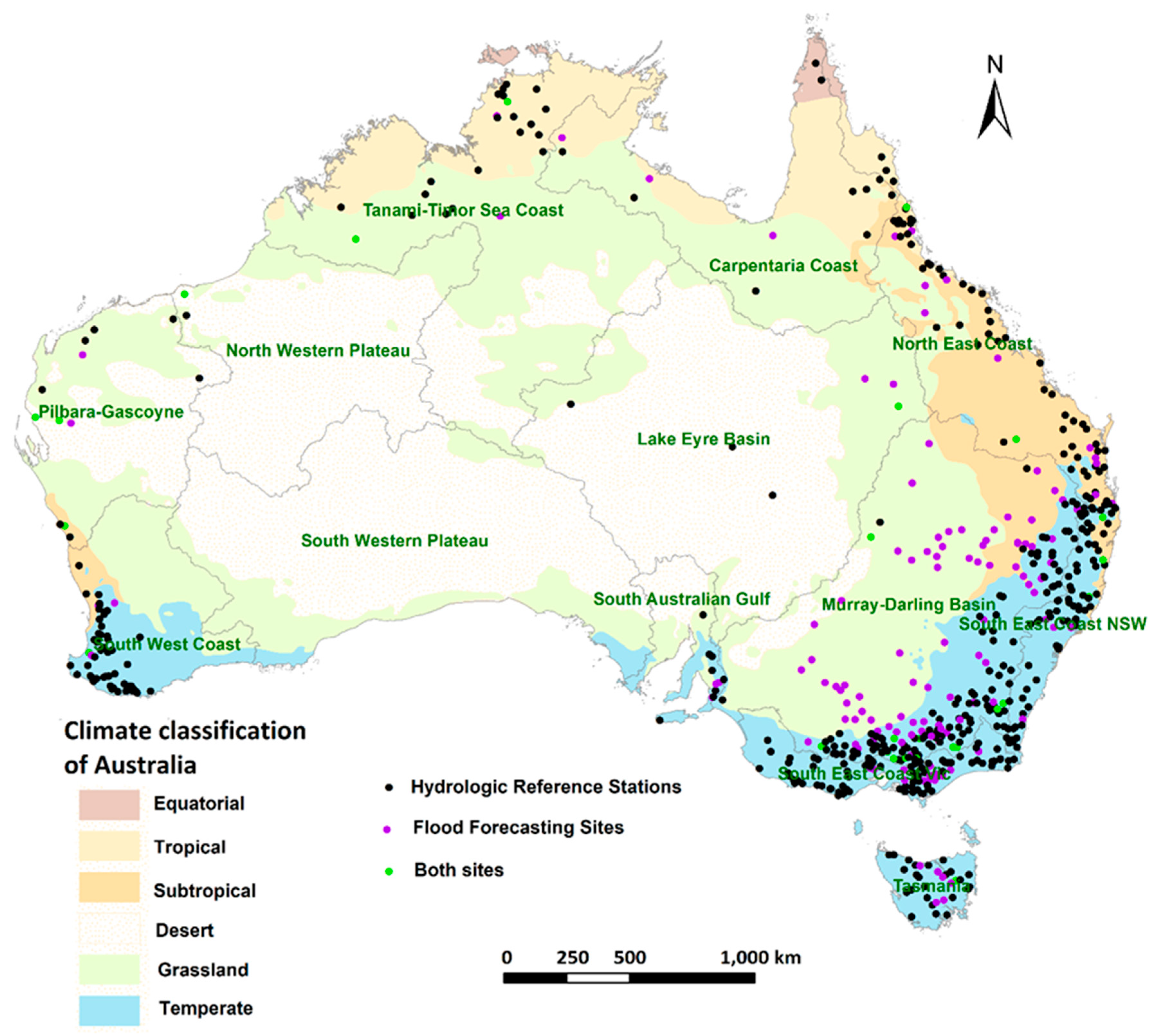
Figure 2.
Record length for the 596 locations, and its distribution across the 12 drainage divisions (SWP has no locations).
Figure 2.
Record length for the 596 locations, and its distribution across the 12 drainage divisions (SWP has no locations).
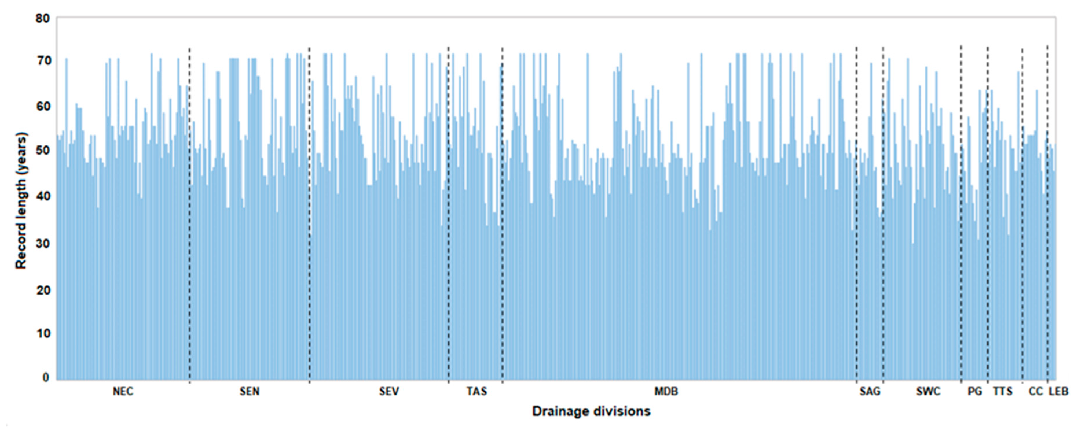
Figure 3.
Flow diagram of trend analyses – Amax and shifts in timing.
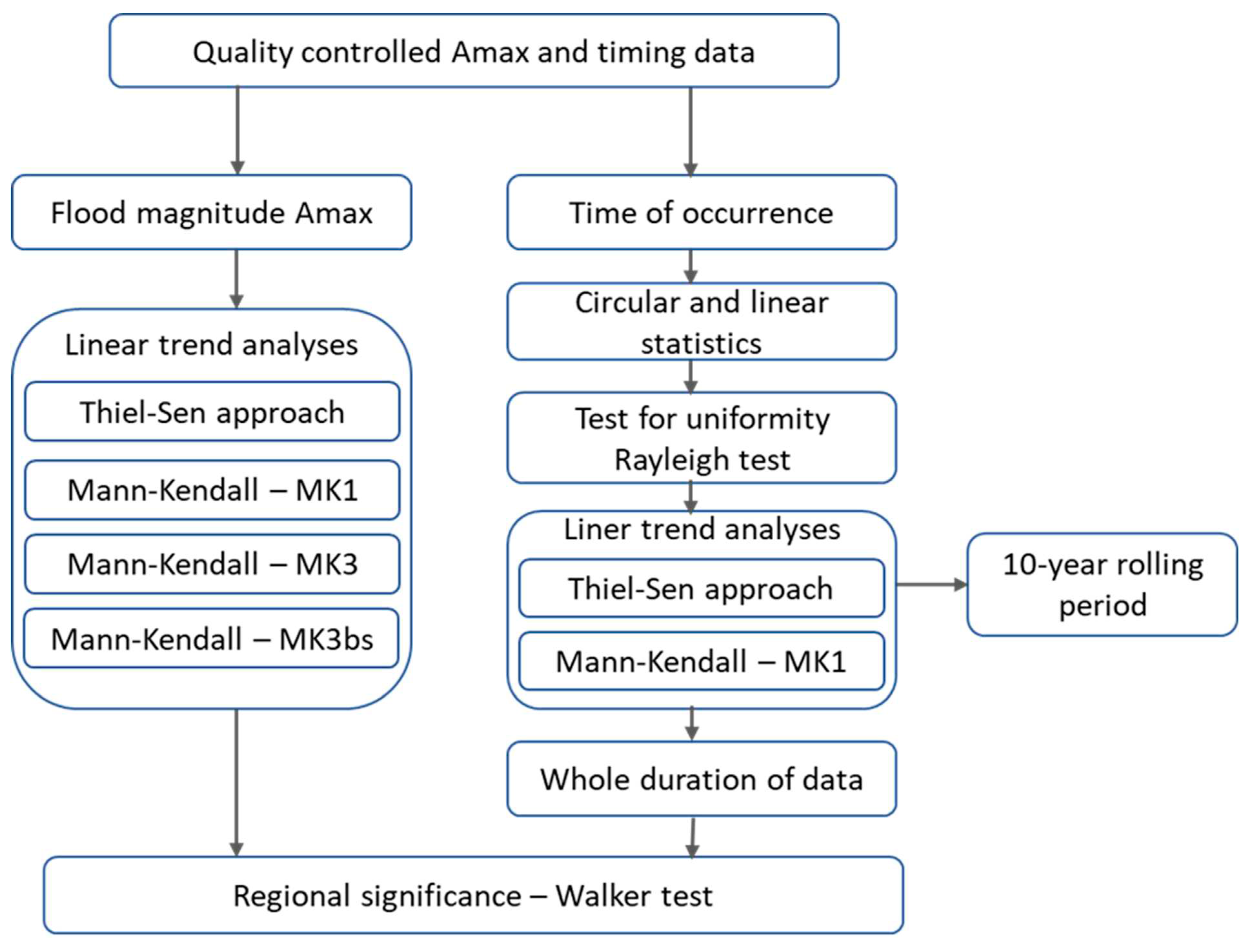
Figure 4.
Box plot of Theil-Sen’s slope (a) in mm/day/decade for Amax and (b) days/decade for timing for stations (n=211 for Amax and n=65 for timing) showing significant statistical trends (p<0.1).
Figure 4.
Box plot of Theil-Sen’s slope (a) in mm/day/decade for Amax and (b) days/decade for timing for stations (n=211 for Amax and n=65 for timing) showing significant statistical trends (p<0.1).
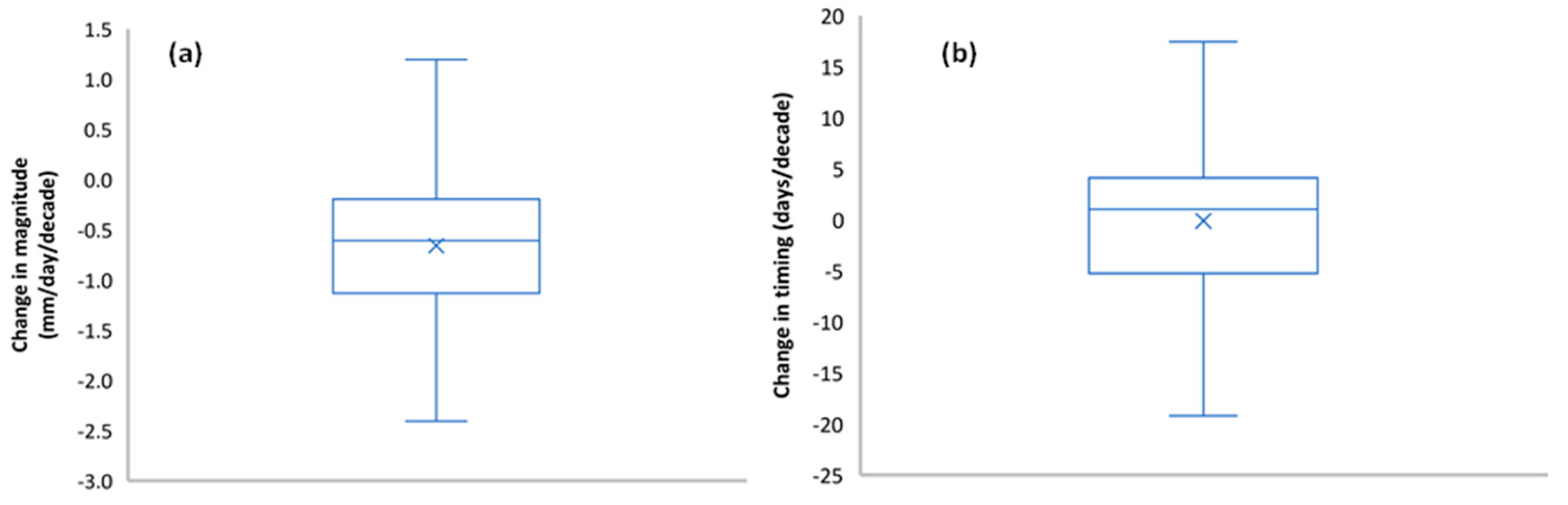
Figure 5.
Examples of typical trends in the magnitude of Amax (a) decreasing in TAS, and (b) increasing in TTS drainage divisions.
Figure 5.
Examples of typical trends in the magnitude of Amax (a) decreasing in TAS, and (b) increasing in TTS drainage divisions.
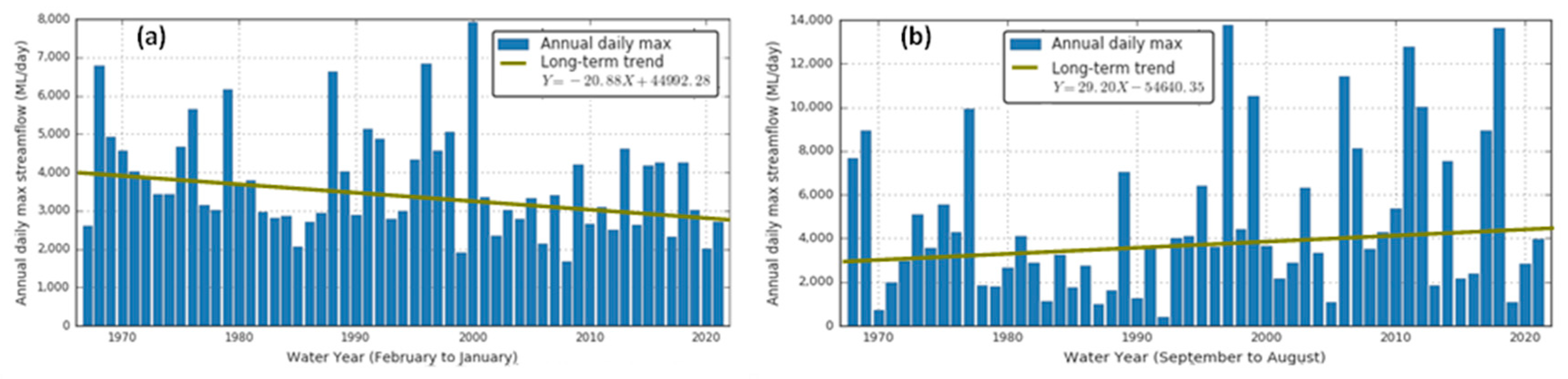
Figure 6.
Maps showing trends in Amax streamflow using (a) MK1, (b) (MK3) and (c) MK3bs tests at p < 0.10. Upward (green) and downward (red) pointing triangles indicate significant increasing and decreasing trends respectively. Blue dots indicate stations with no trends. Divisions with positive and negative trends with field significance at p < 0.10 are coloured blue and yellow, respectively.
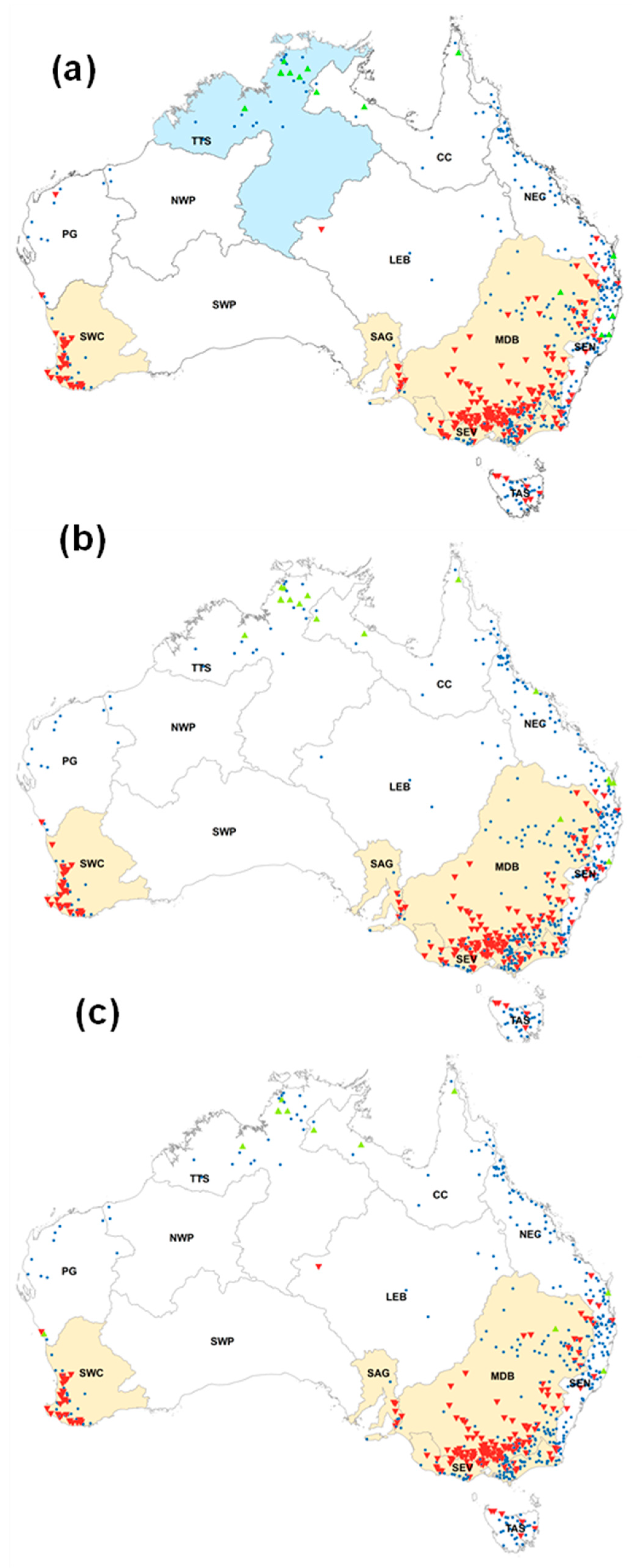
Figure 7.
Streamflow timing: (a) start of site water year, (b) Test of circular uniformity using the Rayleigh test with null hypothesis that the distribution is uniform shows that 592 sites are distributed non-uniformly.
Figure 7.
Streamflow timing: (a) start of site water year, (b) Test of circular uniformity using the Rayleigh test with null hypothesis that the distribution is uniform shows that 592 sites are distributed non-uniformly.
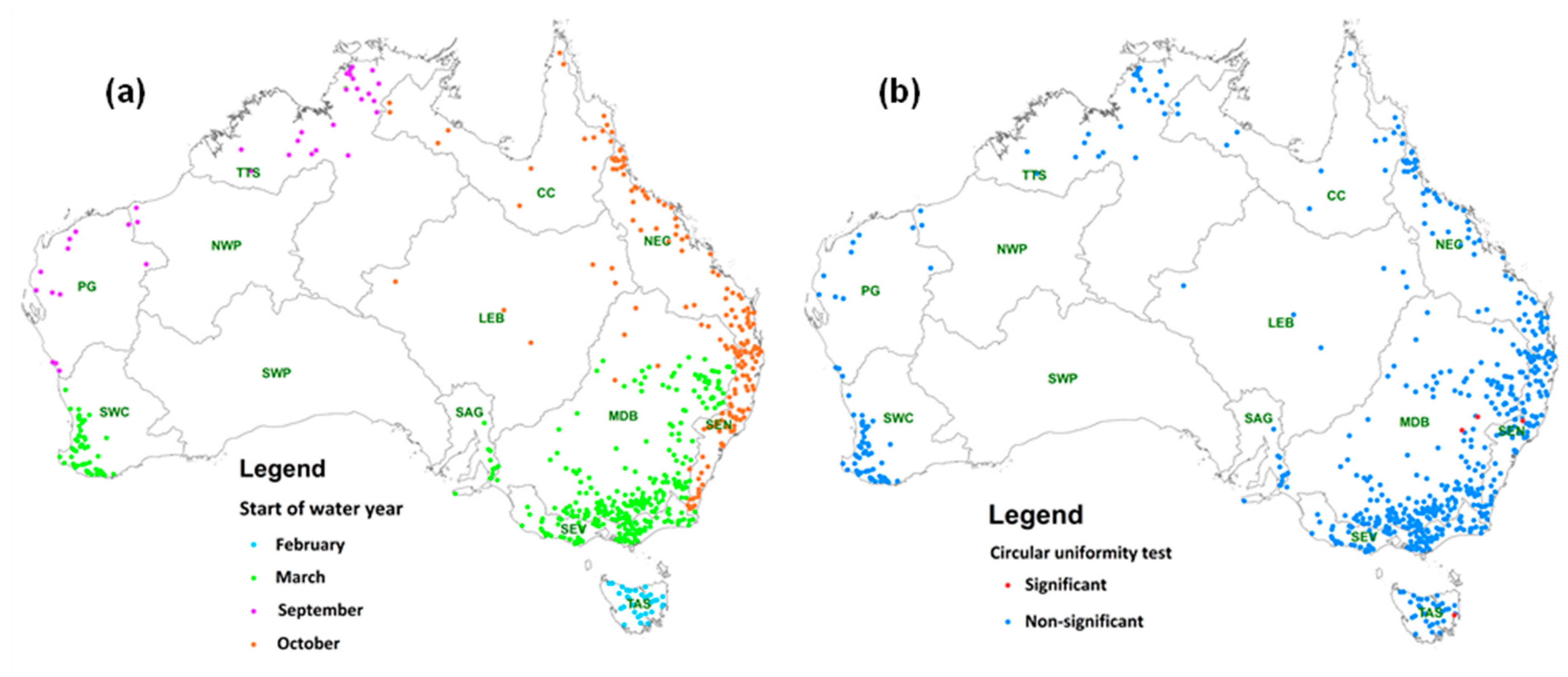
Figure 8.
Timing of Amax peaks (a) number of stations and (b) percent of stations. Amax peaks are concentrated in February-March and August-September.
Figure 8.
Timing of Amax peaks (a) number of stations and (b) percent of stations. Amax peaks are concentrated in February-March and August-September.
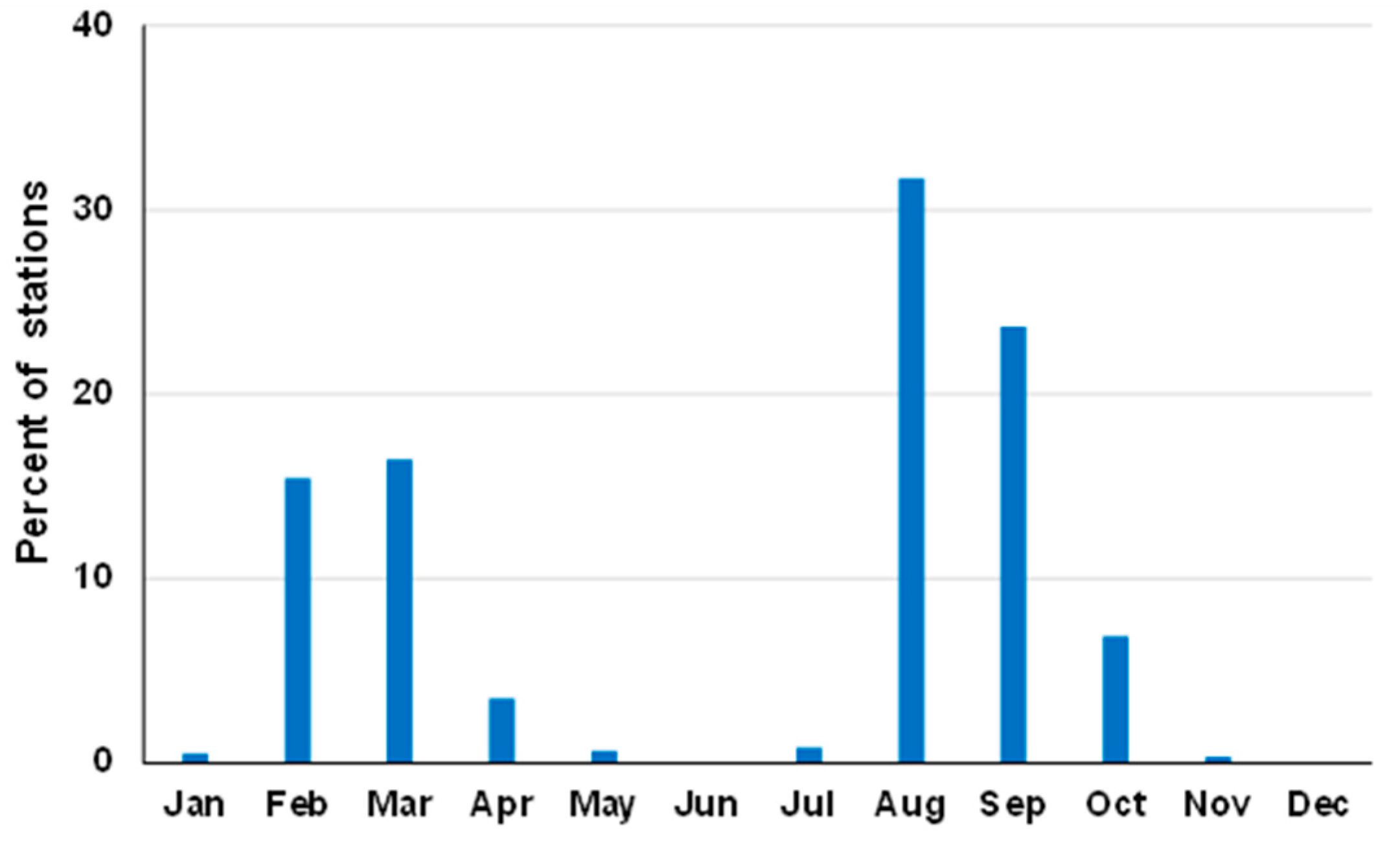
Figure 9.
Observed average timing and seasonality of Amax flood peaks across Australia. Each arrow represents one monitoring station (n = 592). Arow colour, direction and length indicate the average timing and the concentration of Amax (R) within the water year respectively (0: evenly distributed throughout the year; 1: all occur on the same date).
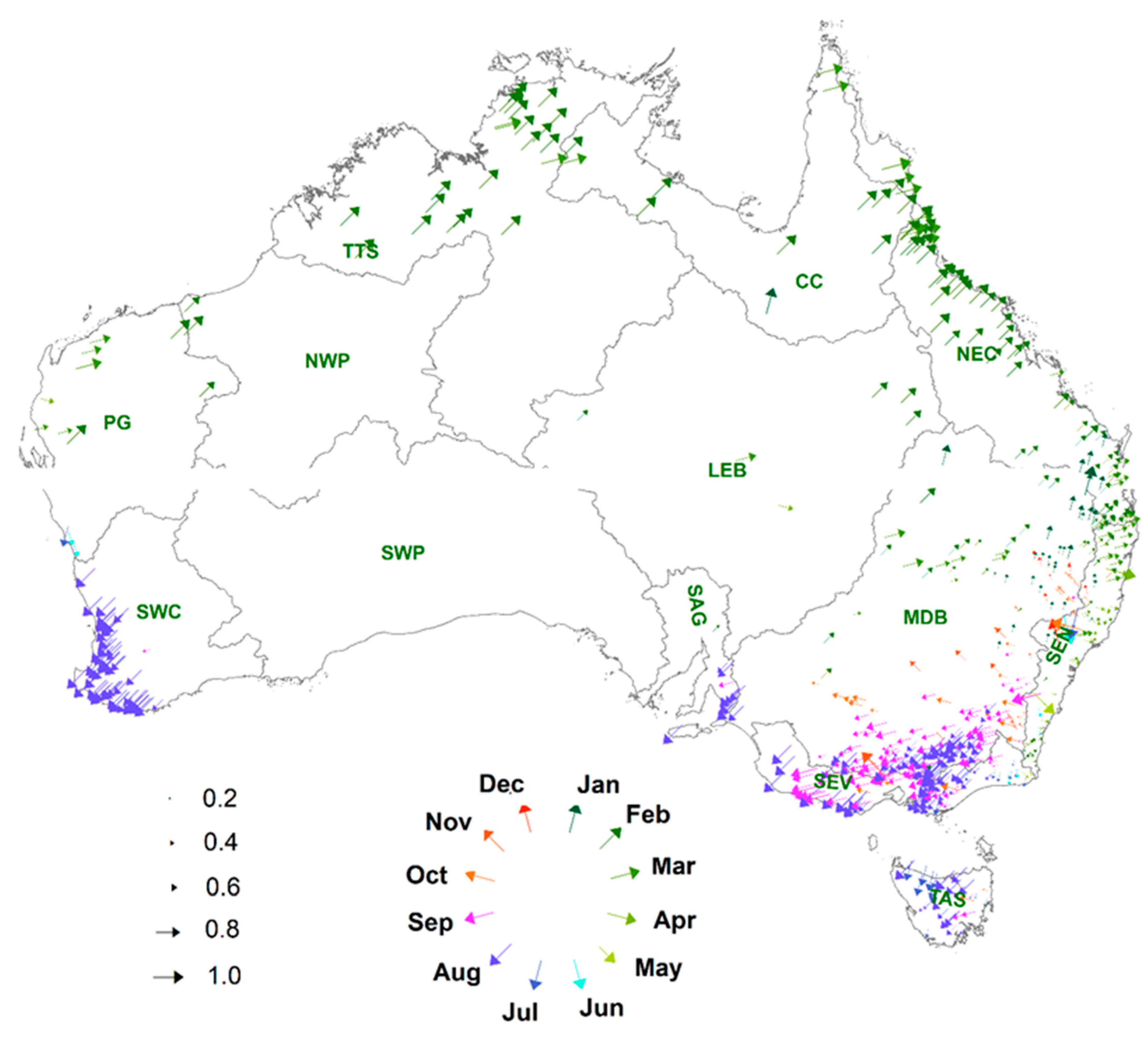
Figure 10.
Linear trend in (a) magnitude and (b) timing using the Theil-Sen estimator for flood (1950-2022). Each dot represents the median trend of the station (n=596). The trend is in (a) mm per decade and (b) days per decade, with red representing a (a) decreasing trend in magnitude and (b) shift to earlier in the water year and blue an (a) increasing trend in magnitude and (b) shift to later in the water year. The sites in (a) (n=212) and (b) (n=65) with dark outer circles refer have significant trends (p < 10%).
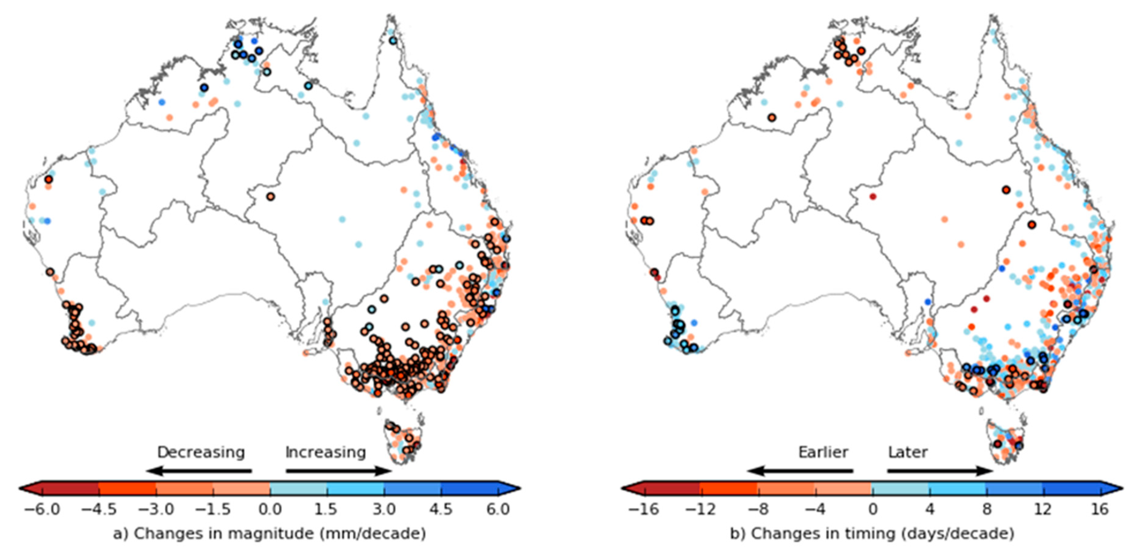
Figure 11.
Long-term temporal changes of timing of floods in 4 selected drainage divisions – (a) NEC, (b) MDB, (c) SWC, and (d) TTS. Solid lines show median timing over the entire drainage division; shaded bands indicate variability of timing within the year (± standard deviations). All data were subjected to a 10-year moving average filter. Other divisions are shown in Figure A1, Appendix A.
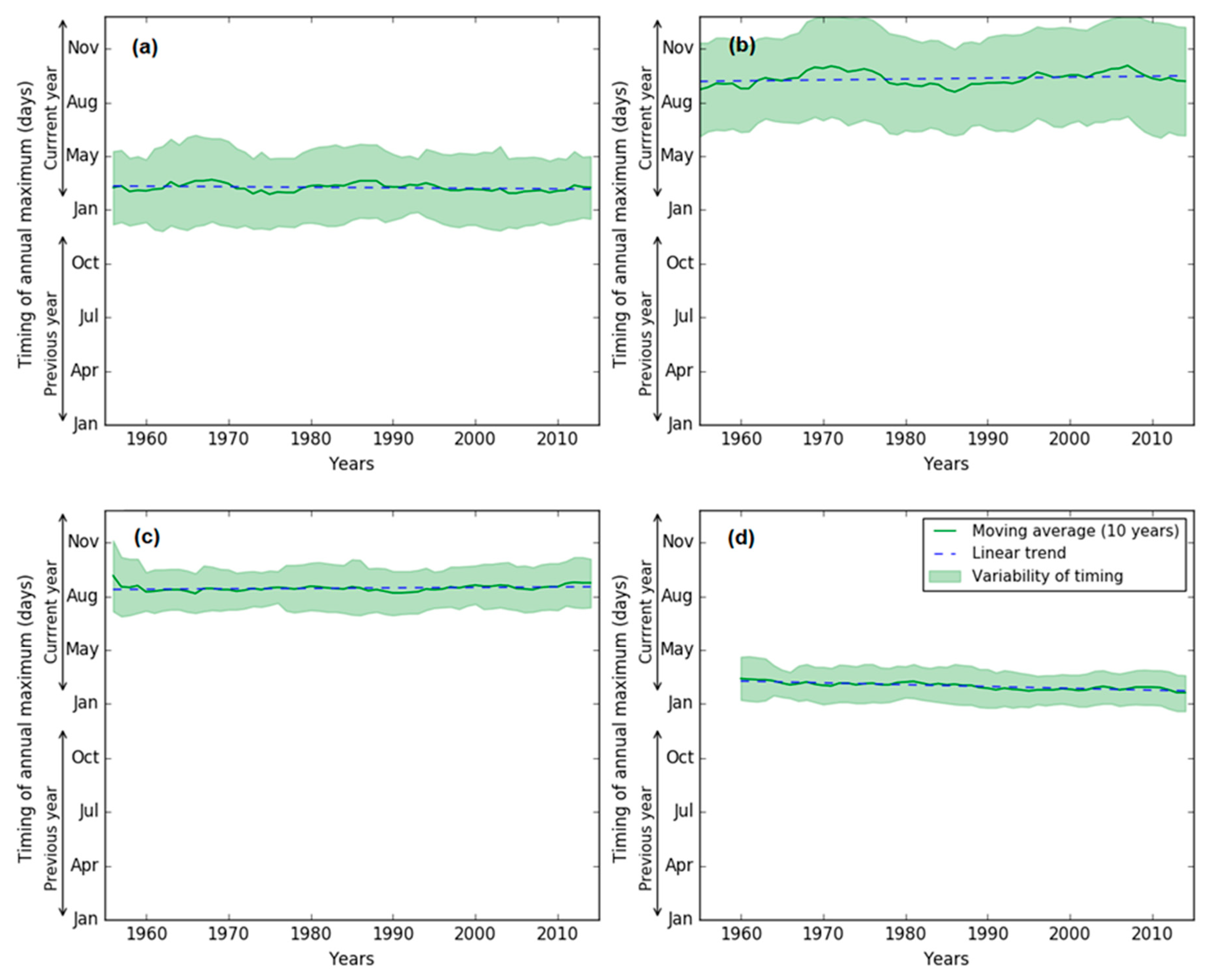
Figure 12.
Relationship of trends in the
magnitude and changes in timing of Amax. Negative and positive values in timing
indicate earlier and later respectively (n=30).
Figure 12.
Relationship of trends in the
magnitude and changes in timing of Amax. Negative and positive values in timing
indicate earlier and later respectively (n=30).
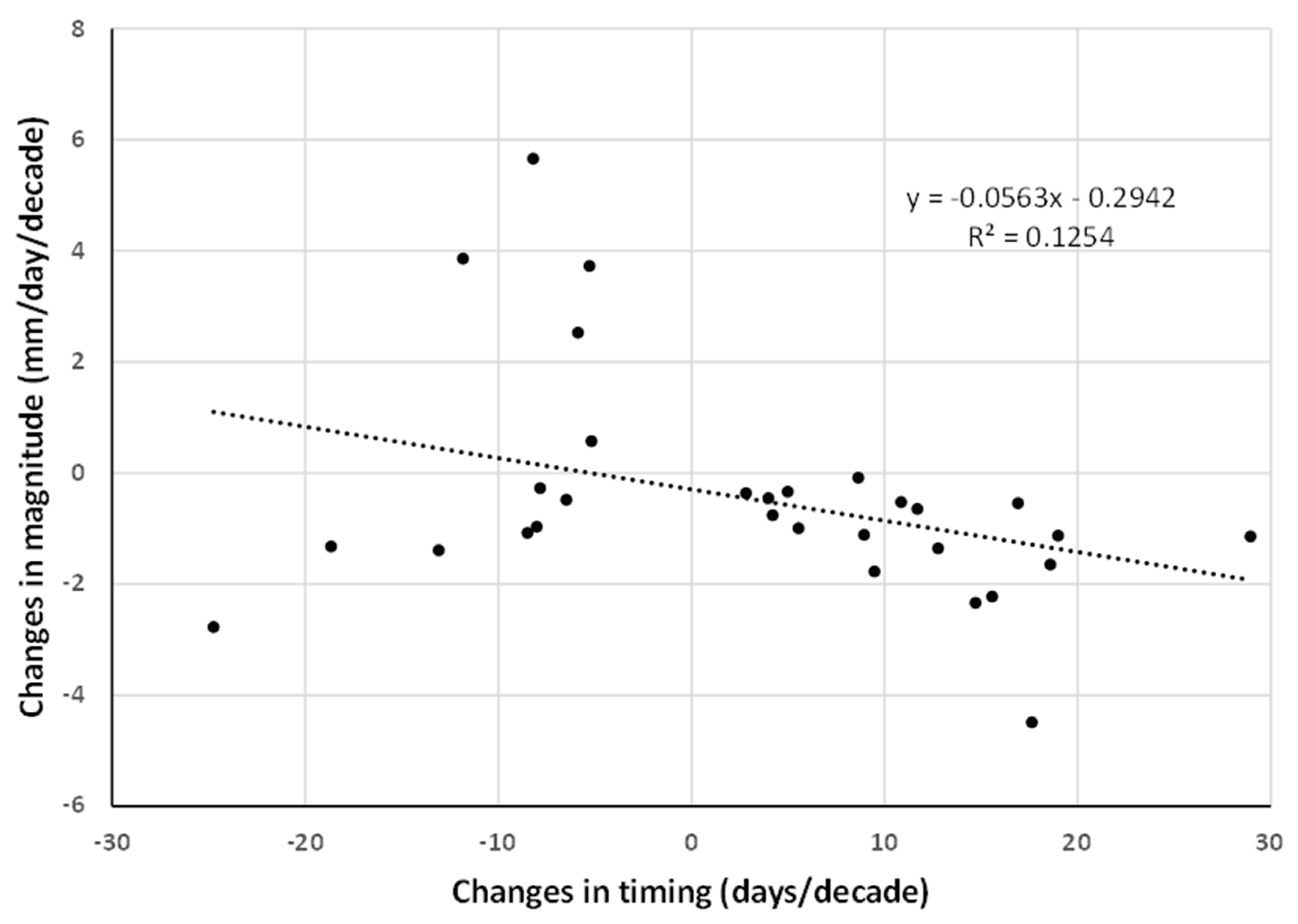

Table 1.
Number of stations showing significant trends (p <0.10) in Amax and timing.
| Code | Drainage division (no. of stations) | Monotonic trend* (+/-) | Timing+/- | ||
|---|---|---|---|---|---|
| Mk1 | Mk3 | Mk3bs | |||
| NEC | North East Coast (77) | 1/5 | 4/3 | 1/4 | 0/0 |
| SEN | South East Coast NSW (68) | 3/11 | 1/11 | 1/6 | 4/1 |
| SEV | South East Coast Vic (88) | 0/34 | 0/33 | 0/26 | 1/12 |
| TAS | Tasmania (31) | 0/7 | 0/5 | 0/6 | 2/1 |
| MDB | Murray-Darling Basin (212) | 1/115 | 1/85 | 1/99 | 10/6 |
| SAG | South Australian Gulf (12) | 1/7 | 1/5 | 1/6 | 0/0 |
| SWC | South West Coast (53) | 0/31 | 0/32 | 0/30 | 14/0 |
| PG | Pilbara-Gascoyne (12) | 0/2 | 0/1 | 1/1 | 0/3 |
| TTS | Tanami-Timor Sea Coast (22) | 6/0 | 7/0 | 4/0 | 0/10 |
| CC | Carpentaria Coast (13) | 3/0 | 3/0 | 3/0 | 0/0 |
| LEB | Lake Eyre Basin (6) | 0/1 | 0/0 | 0/1 | 0/1 |
| NWP | North Western Plateau (2) | 0/0 | 0/0 | 0/0 | 0/0 |
| SWP | South Western Plateau (0) | -- | -- | -- | |
| Total (596) | 15/213 | 17/175 | 12/179 | 31/34 | |
+ Number of stations showing increasing shifts. - Number of stations showing decreasing shifts. * Entries in bold indicate results that are field significant at p < 0.10.
Table 2.
Summary of regional significance (p=0.10) (√) across different drainage divisions – Amax magnitude and timing.
Table 2.
Summary of regional significance (p=0.10) (√) across different drainage divisions – Amax magnitude and timing.
| Drainage division | Drainage division (no. of stations) | Magnitude | Timing | ||
| Mk1 | Mk3 | Mk3bs | Mk1 | ||
| EC | North East Coast (77) | ||||
| SEN | South East Coast NSW (68) | ||||
| SEV | South East Coast Vic (88) | √ | √ | √ | |
| TAS | Tasmania (31) | √ | |||
| MDB | Murray-Darling Basin (212) | √ | √ | √ | |
| SAG | South Australian Gulf (12) | √ | √ | √ | |
| SWC | South West Coast (53) | √ | √ | √ | |
| PG | Pilbara-Gascoyne (12) | √ | √ | √ | |
| TTS | Tanami-Timor Sea Coast (22) | √ | √ | ||
| CC | Carpentaria Coast (13) | ||||
| LEB | Lake Eyre Basin (6) | √ | √ | ||
| NWP | North Western Plateau (2) | ||||
| SWP | South Western Plateau (0) | ||||
Disclaimer/Publisher’s Note: The statements, opinions and data contained in all publications are solely those of the individual author(s) and contributor(s) and not of MDPI and/or the editor(s). MDPI and/or the editor(s) disclaim responsibility for any injury to people or property resulting from any ideas, methods, instructions or products referred to in the content. |
© 2023 by the authors. Licensee MDPI, Basel, Switzerland. This article is an open access article distributed under the terms and conditions of the Creative Commons Attribution (CC BY) license (https://creativecommons.org/licenses/by/4.0/).
Copyright: This open access article is published under a Creative Commons CC BY 4.0 license, which permit the free download, distribution, and reuse, provided that the author and preprint are cited in any reuse.


