Submitted:
28 June 2023
Posted:
29 June 2023
You are already at the latest version
Abstract
In this paper an overview of waste materials in underground coal mines is presented, whereas waste materials can be of anthropogenic or geogenic origin. Complex interactions with mine water and waste materials take place, especially during mine water level rebound. Bearing in mind that under the increasing societal pressure most, if not all underground coal mines are going to be closed rather sooner than later, it is important to understand these interactions and to predict the composition and dynamics of mine water lever rebound in underground coal mines to prevent adverse effects to the environment, especially receiving waters and drinking water resources. The second part of this article focusses on the experiences gained in the Ruhr area, a closed underground coal mining region in Western Germany, where mine water rebound has been ongoing for decades. In this regard, the modelling program DMT-Boxmodel has been developed and applied to predict the hydrodynamics and hydrogeochemical development of the water rebound. As an example, simulation results of water rebound as well as solute and PCB transport in central province of Ruhr mining area are compared to the monitoring data, and predictions over 3 decades are given. The experiences gained in the mine water management in Ruhr area can be applied in mining areas worldwide.
Keywords:
Coalmine: Waste material
; DMT-Boxmodel
; Reactive transport
; Mine water level rebound
1. Introduction
Mining is finite, yet the consequences of mining may be enduring if they are not addressed with the necessary diligence. Furthermore, the extracted material may have adverse environmental consequences, too, which is the case when coal is used as a fuel. Together this makes coal mining unattractive form a wider society point of view and consequently many scientists and policy makers consider a (global) termination of coal mining. Consequently, even if coal mining is economically successful in some cases, a termination of the operation will occur, rather sooner than later due to the adverse environmental impacts. One important aspect of coalmine closure is mine water management.
During operation, mine water is pumped which drains the groundwater of the entire region up until the deepest depth of the mine, leaving shallower extraction levels above the water table. In the period of their abandonment, mine water drainage systems are no longer required, pumping is stopped, and consequently the mine water will rise until it reaches natural or a planned level. Typical questions arising in this context are related to the duration of mine water level rebound, the flow volumes and geochemical composition of mine water at decant points. From the analysis of 97 closed underground and open cut coal mines in Europe Gombert et al. 2019 [1] conclude that the quantitative influence of coal mine water discharges is “substantial” and that “evaluating their environmental impact on surface and underground water is important”. Currently approximately 1600 active coalmines exist worldwide, whereby more than 50 % of these are underground operations [2]. According to “Forum Bergbau Wasser” [3], around 92 million cubic meters of mine water are pumped each year at the two largest mine sites in Germany alone. Therefore, the importance to know the potential contaminant sources and to understand the transport processes involved in order to mitigate the environmental impact caused by mine water is underlined.
This article focusses on mine water management and the mobilization, transport and discharge of contaminants contained in waste materials, deposited in underground coalmines. Within the Ruhr area, which is used as a case study in this article, diligent planning of mine water level rise has prevented adverse effects on the environment. Indeed, the quality of surface waters has significantly increased over the last decades. In order to achieve this goal detailed knowledge is required on
- the quantity and type of wastes in underground coal mines
- the extent of underground workings and connections between mines
- the transport mechanisms of various types of contaminants
- the use of specialized mine water modelling software as prediction tool.
2. Waste Materials in Underground Coalmines
Waste Types
For the purpose of this article “wastes” are seen as substances that occur in underground coalmines due to anthropogenic influence and that may have an effect on mine water chemical composition. A list of common wastes in underground mines are given in Table 1. If the substance is naturally occurring and has not been modified significantly, it is addressed as a geogenic potential contamination source. This applies to e.g. to the host rock exposed in galleries and shafts as well as fractured rock and residual coal in the goaf areas.
2.1. Sulfate Oxidation and Acid Mine Drainage
Even without the contribution of anthropogenic wastes the naturally occurring material inside underground coalmines may cause mine water contamination e.g. acid mine drainage (AMD). Coal deposits often contain sulfide minerals because the depositional environment favored the precipitation of these minerals [8]. Mining activity changes the reducing environment and brings sulfide minerals (e.g. pyrite) in contact with oxygen and water (oxidizing condition). The resulting oxidization of pyrite produces sulfate, iron and substantial amounts of acid when not buffered by carbonate rocks. In general, higher content of sulfide minerals in coal deposits results in higher concentrations of the potential pollutants such as metals, sulfate and iron (Younger, 2002).
Acid mine drainage has been reported for many coal mining areas worldwide; Wang et al. (2021) [9] reviewed acid mine drainage due to coal mining in the US, India, South Africa, China and Europe. Their review focusses on abandoned mines including underground and open-pit mining at small scale, i.e. isolated coalmines and large scale mining regions such as the Shanxi Region in China with interconnected underground mines. Further cases regarding AMD in underground coalmines is reported by Wood et al. (1999) [10] for abandoned mines in Scotland. Here the authors conclude that AMD resulted in water contamination within the first decades after mine closure, whereas after 40 years of mine closure water pH increased and consequently contaminants level decreased. Lambert et al. (2004) [11] conclude for underground coal mines in the Uniontown Syncline, Fayette County, PA, USA that the rate and degree of water quality improvement is dependent on the mine flooding rate, whereby mines with a high degree of flooding show a significantly higher degree and rate of water quality improvement. Abandoned coal mines in Shanxi, China, form an interconnected underground mining region where shafts and connections where not effectively blocked to prevent water exchange between deeper contaminated mine water and near surface groundwater. This has resulted in a drinking water safety crisis [9]. Notably, for the underground mining regions in Germany, i.e. the Saar area and Ruhr area AMD is not an issue because of sufficient carbonate content in the host rock [12]. Only in the Ibbenbüren mine, which is characterized by a different lithology (sandstone), acid mine water has occurred in the previous flooding process. However, the mine water in deep coalmines is usually highly saline, due to the interaction with host rocks and in case of intrusion to surface waters it may cause serious environmental problem.
2.1. Backfill Material
The deposition of mining waste material as backfill material in underground mines is a common worldwide practice. The reasons for backfilling the material are related to geotechnical concerns, e.g. to decrease ground subsidence effects. The backfill materials can be of various origin. In the Ruhr area, for example, waste materials from municipal waste combustion was used as backfill material next to wastes from flue gas desulphurization (see Kessler et al. 2020 [12], RAG 2014 [13]). These materials are usually mixed with cement prior to deposition [14]. Due to the mine water rebound, the backfill material comes into contact with water and, under unfavorable conditions, the contaminants may be released in to the mine water. In cases where insufficient or no documentation on deposited wastes exists the risk magnitude cannot be directly assessed. Monitoring of water quality and quantity changes however can be helpful to distinguish the source of contamination (see Bedford et al. 2022 [15]).
2.1. PCB and PCDM
Lubricants and oils are and have been used underground and diesel oil is used as fuel in the locomotives of most mines [16]. Such mineral oil products which may have leaked into the mining gallery ground are, to a large extent, complex mixtures of mineral oil hydrocarbons with different properties. In particular, diesel oils have relevant water-soluble fractions. Water solubility of these hydrocarbons decreases with increasing molecule length [16].
In addition, due to the widespread use of hydraulic fluids in coal mines, hydraulic fluids are an important source of contamination. Since the discovery of PCBs (polychlorinated biphenyls) as non-flammable components in hydraulic fluids in the 1960's, they have been used extensively in mines. PCBs are chemical chlorine compounds that were used in, hydraulic systems, transformers and gearboxes in coal mining, amongst other materials. In the US the production of PCBs was prohibited in 1978 by the Environmental Protection Authority (EPA) due to its toxic properties [17]. However, in mining PCBs were still used in machines, which were then abandoned in underground mines. In Germany, the use of PCB in mining was discontinued in mid 1980s and instead the PCB alternative PCDM was used from 1984, which however proved to be as hazardous to health. Finally, in 1989 the application of PCDM entirely ceased, so that the total amount of PCDM used in German coalmines is small in comparison with PCB. However, due to leakages, defects or the hosing down of the machines for safety reasons PCB accumulated in underground mines. Ultimately, it can be stated that PCBs are almost always present in the old mines, especially in the vicinity of shafts, due to driving, later use and carry-over. Peripheral mine workings excavated after the PCB period of use can be considered PCB-free. On a global scale the extent of the contamination can hardly be quantified today. Klinger et al. 2018 [7] estimate that between 1964 – 1984 roughly 5.000 – 7.000 tons of PCB are deposited in underground mines only in the western part of the Ruhr area [14].
2. Underground Mining in Ruhr Area
To shed light on the processes and prediction methods of contaminant transport during mine water rebound the underground mining region of the Ruhr area constitutes an exceptionally well documented example. The Ruhr area is located in western Germany and consists of several cities (see Figure 1). Approximately 5,05 million inhabitants live in the Ruhr Area, which has a surface extent of 4.436 km2, resulting in ~1.140 inhabitants/km2 making it one of the most densely populated regions in Germany.
The former coal mining area is huge comprising dozens of neighboring and interconnected underground coalmines, where mining was performed for centuries. Coal mine closure and associated mine water rebound in the Ruhr area is a continuous and ongoing task. The last two coalmines in the Ruhr Area closed in 2018. Today the main water management challenge is to prevent the contact of the mine water with near surface ground water, which is used as drinking water resource. Another important aspect is the discharge of drained mine water into receiving waters (rivers) and therefore predicting mine water and surface water chemistry development.
In order to continuously reduce these unacceptable effects a mine water management concept was developed by the former coalmine operator, the RAG, in 2014 (see [13] ). This initial concept is under constant review by the responsible mining authorities and, in addition, is being constantly optimized in order to reduce environmental effects caused by e.g. CO2 emissions from ongoing mine water pumping.
As previously pointed out, the main wave of closures of the coal mines in the Ruhr area began in the 1960s. Due to close proximity of underground mines and hydraulic interconnectivity through roadways, water management had to be maintained in closed underground mine workings, to prevent water intrusion into neighboring (active) mines. As a result, the Ruhr Area has been subdivided into several so called water management provinces, with central water pumping stations. In 1969, for example, 25 drainage systems were used to drain mine water and protect the active mines [18]. In the following years, as coalmine closure continued, the number of drainage systems was decreased/optimized. The current water management plan for the Ruhr Area [13] envisages to use only six drainage installations for the entire Ruhr area (see Figure 2 and Table 2). The planning phase of this ambitious goal required extensive water rebound modelling and prediction.
2. Specialized Mine Water Modelling Software as Prediction Tool
Numerical mine water models have been established in the past decades, which are able to recalculate mine water flows, mine water levels, substance concentrations and temperatures and predicting them with regard to changes in mine water management. Large-scale mine water flows differ from groundwater flows in that they occur mainly on mining elements such as drifts, shafts, boreholes and galleries and that these waters are hydraulically short-circuited within the mine fields or large homogeneous units. Accordingly, representative mean values for certain variables such as the mine water level or a substance concentration can be used for the individual balance units (elements of spatial discretization). This allows the definition of relatively large balance units (mine fields or mines) to describe flow processes. In Germany, this concept was implemented for the first time in 1991 at the Ronneburg uranium deposit. As part of the NRW Mining Technology Program, it was adapted by DMT from 2002 onwards in a research project specifically for the German hard coal industry (DSK, now RAG) and the Boxmodel program was introduced [20]. The Boxmodel has been applied in Germany (Ruhr area, Saarland, Ibbenbüren) and in many hard coal deposits in Europe, as well as in other deposits such as the East Rand Basin in South Africa [20,21].
Boxmodel represents a finite volume simulation software for 3D modelling of mine water flow including heat and (reactive) mass transport in coupled systems [22]. It contains the complete modelling workflow from geometry to post-processing including conversion possibilities for geological modelling tools. A model consists of freely structurable polygons (boxes) according to the finite volume method, which can consider defined irregular geometries with a large degree of discretization flexibility. These boxes represent neighboring, underground mines with different types of interconnection. Boxmodel is used to calculate the transient three-dimensional mine water flow and the reactive mass transport. The water balance provides inflows from different sources as well as various hydraulic elements such as aquifers, mining galleries, faults and pumps. All flow forms, laminar and turbulent flow as well as the temporal variability of hydraulic properties are treated. The calculated water levels in the Boxmodel correspond to the water levels in the open roadway system of the mine fields, i.e. boxes, assuming that there is an hydraulic short circuit within the respective mine field in the depth range of the actual mining operation due to the numerous drifts/drilling operations. An example for box discretization and connections is shown in Figure 3 and Figure 4 for the Ruhr area in Germany. In Boxmodel all relevant input data such as pump performance curves, complicate network of roadways, drifts and shafts, short cuts between mining fields, hydraulic connections and many more properties can be considered. Moreover, it allows for the simulation of parallel multi-component transport, modified sorption potential per transport unit, geochemical reactions and microbiological degradation. Therewith, it provides a wide range of pre-installed transport units (such as MKW, PAH, VOC, SO4, CO3, Fe, pH-, Eh-calculation). The modification of the transport units and processes considered is freely extendable. The most recent development includes extensions to predict the effects of climate change on mine water management (see Bedford et al. 2022 [15]).
For the prediction of mine water qualities including e.g. mobilization and transport of PCB the Boxmodel is a renowned tool available for simulating large scale water management concepts. Conventional numerical model applications, e.g. Feflow, Modflow, Spring, etc. would suffer issues in model set-up, i.e. discretization, and calculation speed or limited calculation of chemical reactions.
2. Case study: Water Management in the Central Water Province of the Ruhr area - Germany
From a regulatory point of view, the discontinuation of mining and associated water management requires approval from authorities. In order to obtain approval, closure management plans need to be prepared, which require extensive documentation on all activities involved to close the mine. This includes most notably also water management activities. In order to assess the effects of mine water level rebound in the so called central water province of the Ruhr area from -1300 amsl to -630 amsl a feasibility study was prepared in 2020 by RAG [19], prior to the actual closure management plan, which received approval from the authorities in 2021. For the feasibility study the Boxmodel was used to investigate and predict several aspects of the planned mine water level rise including substance mobilization, transport and discharge. The results of these investigations with regard to underground wastes are presented here.
The central water province has a surface extend of 1.155 km2 (see Figure 3 and Figure 4). The province consists of a large number of mines, which operated in the last decades and were successively merged into larger units (see Table 2). The Boxmodel distinguishes 82 sub-units (boxes), which are shown in Figure 3. The boxes represent former individual mines with homogenous properties and interconnections. After the end of active coal mining in the last Prosper-Haniel mine still in operation in the region (by the end of 2018), water pumping was stopped there (2021) and in the Auguste Victoria mine to the north (May 2019). After that, there was also the option of stopping the Zollverein, Carolinenglück and Amalie dewatering systems and allowing the mine water level to rise over a large area.
2.1. Simulation of Mine Water Rebound and Hydraulic Situation
As already explained the plan is to install a central pumping station at the Lohberg sub province, which is capable of controlling the mine water level within the entire central water province. According to the water management concept, mine water level at Lohberg sub province will be kept at -630 masl. Fig. shows the catchment area of the planned system with the sub-provinces delineated in color.
Figure 5.
Water levels and the water flow directions in the central water province after stop of pumping in 2022/2023.
Figure 5.
Water levels and the water flow directions in the central water province after stop of pumping in 2022/2023.
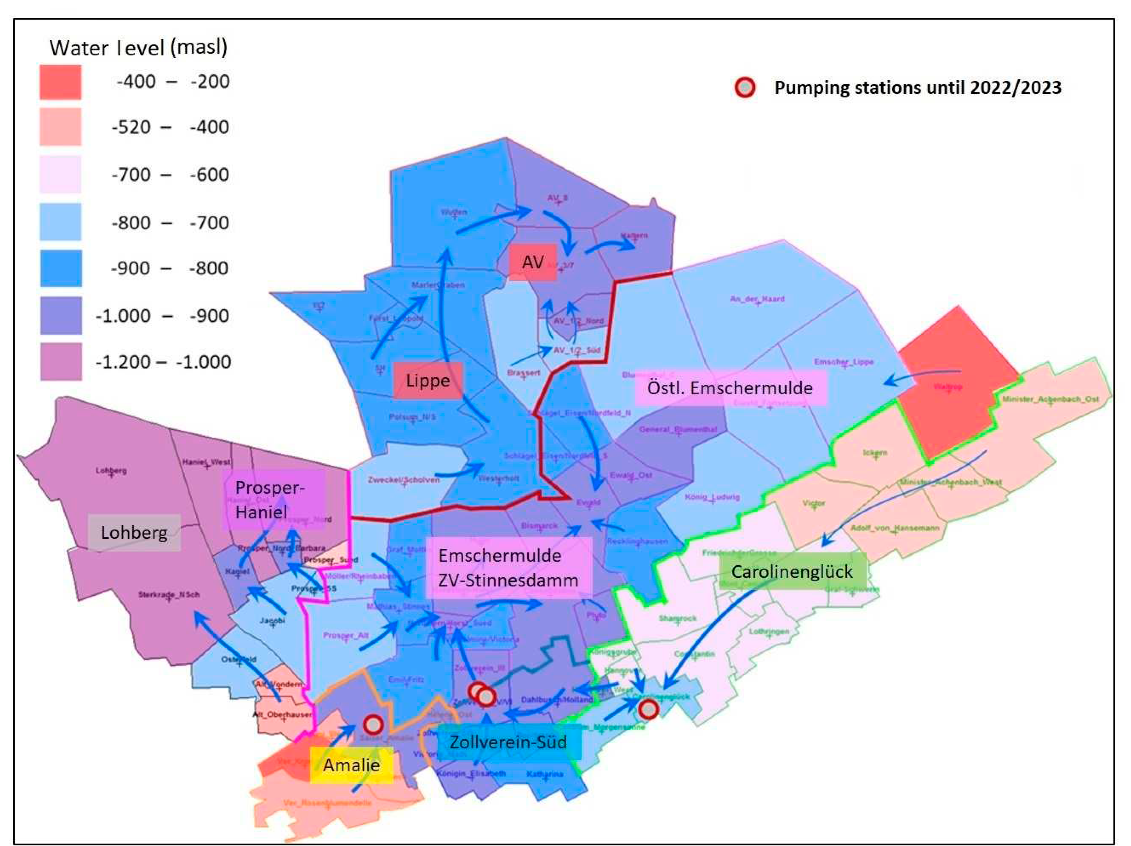
In Fig. the water level and main flow paths in the central water province directly after cessation of the last 4 pumping stations in the south is shown. In the beginning of 2023 the plans of the feasibility study were implemented and these pumping stations in Zollverein, Carolinenglück and Amalie were stopped. Now the water level rises in these sub provinces but due to short time span the water levels show more or less still the last pumping levels, i.e. that they have since increased only in the range of 10 to 50 meters. In Fig. the predicted time dependent water level rise is presented. The current hydraulic situation is characterized by different water levels in the different boxes. In most of the sub provinces the water level currently is in rising phase with different rising speed. This is due to the different dewatering termination times and the distinct excavation / void volumes in the mining areas. In addition, naturally occurring inflow rates are variable, which are mainly concentrated in the southern area. The model is calibrated by using historic mine water level and pumping rate monitoring data for each individual mine.
Figure 6.
Simulated (solid lines) and monitoring data (symbols) of the pumping rate and water levels (dashed lines) in the central water province. Note that between 2022 and 2030 water pumping out was stopped.
Figure 6.
Simulated (solid lines) and monitoring data (symbols) of the pumping rate and water levels (dashed lines) in the central water province. Note that between 2022 and 2030 water pumping out was stopped.
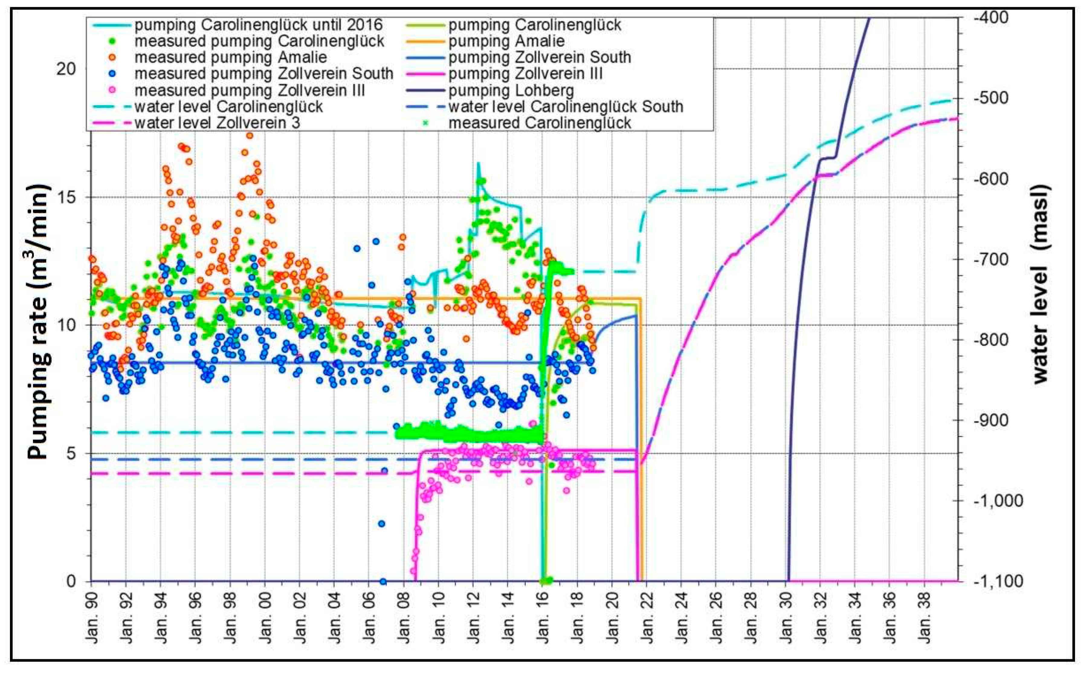
Figure 7.
Predicted water levels and the water flow directions in the central water province in final situation.
Figure 7.
Predicted water levels and the water flow directions in the central water province in final situation.
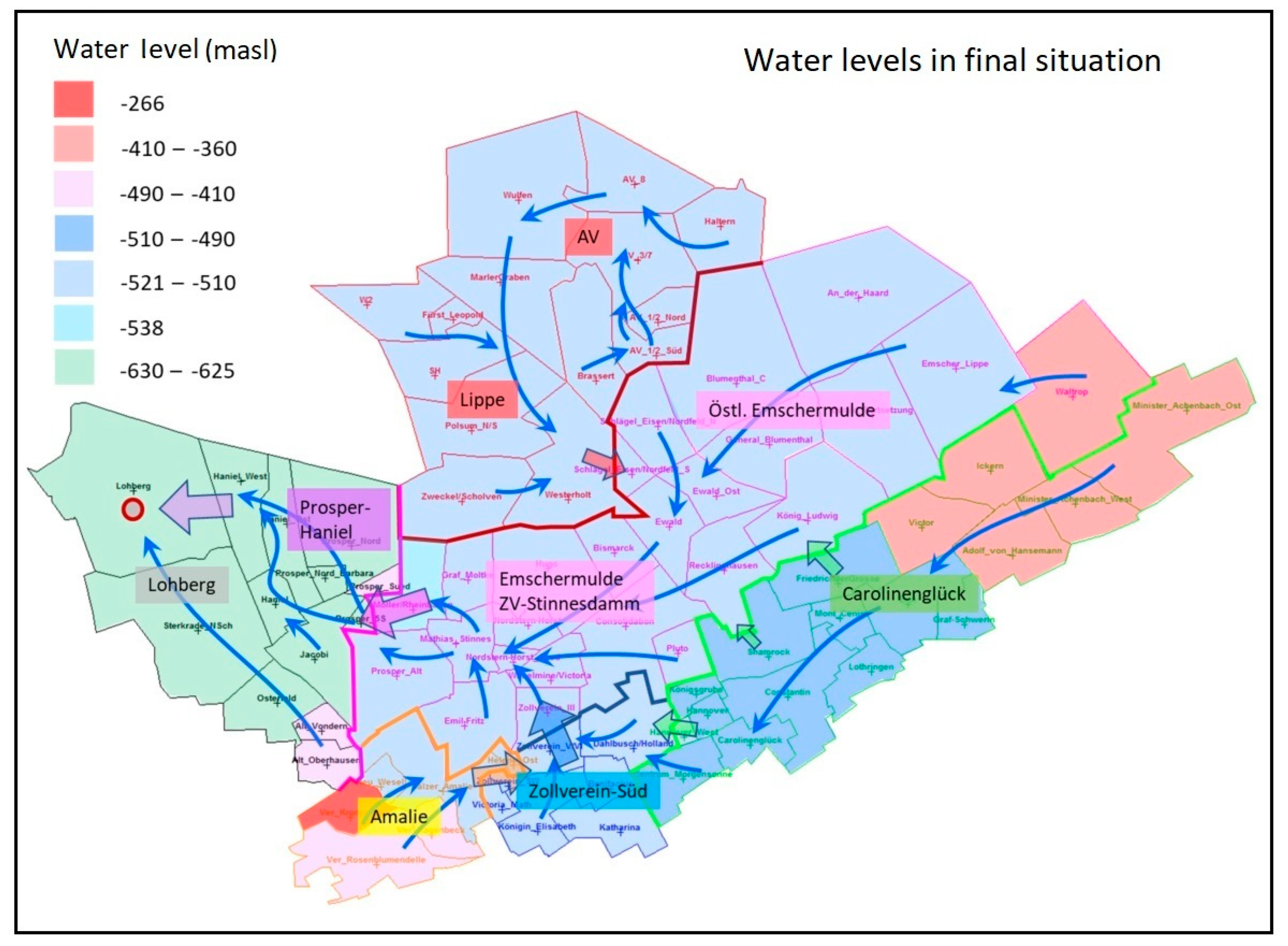
Fig. shows the predicted water levels in the central water province with the preferential water flow directions (blue arrows) after installation of the Lohberg pumping station. It is expected that at -600 m additional pump is needed to transfer water from ZV-Stinnesdam to Lohberg. Following this initial prediction of the mine water rise it must be investigated if the rising of water level can cause unacceptable effects such as water contamination. Even if in this case the mine water level is kept below sensitive groundwater bodies, this question of quality is of fundamental importance for the discharge of the mine water into the receiving water. Thus, simulation of mine water rising and predicting of water quality and potentially contaminants is of crucial importance.
6.2. Simulation of Solute Transport
The water composition in coal mining regions is mainly influenced by the chemical composition of the inflow waters, pyrite oxidation, and water mixing with mineral precipitation and sedimentation as well as microbial activities such as sulfate reducing bacteria. All these processes are considered in the Boxmodel. The model takes various processes into account to describe the mass transport: solute transport as dissolved aquatic species, and colloidal transport for non-dissolved components (PCB transport). Typical developments in mine water are explained below using a few important components, the behavior of which can serve as a representative of the various groups of substances in mine water. This is shown for the substance developments that were determined in the last water drainage systems in the Lohberg water province, in order to illustrate both the variability of the inflows and the model calibration and the forecast based on it.
- Chloride:
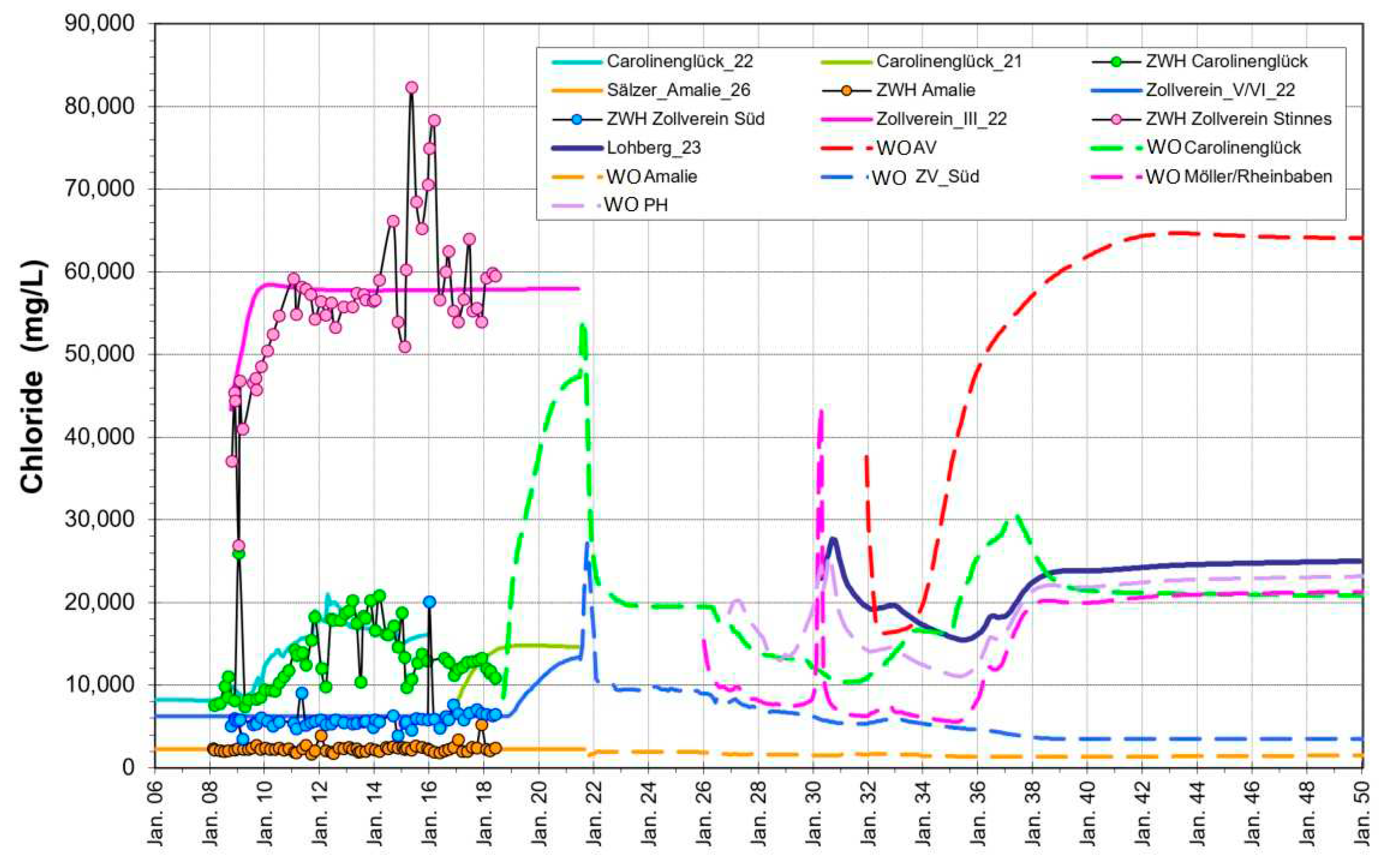
As a highly soluble component representing the total salinity of mine water, chloride is a suitable parameter for understanding flow and water mixing processes, which is hardly subject to chemical precipitation reactions and thus behave like a tracer. The time dependent chloride concentration in the central water province is shown in Fig.
Results reveal a high salinity in the central deep Emschermulde (Zollverein Stinnesdamm) with a Cl concentration of ~57 g/L and a low salinity in the south (Water Overflow Amalie (WO Amalie), Cl ≃ 2g/L), where, however, high flow rates exist. After the water rise in the central water province mixing of inflow waters result in a mine water with about 20 g/L chloride. Highly saline mine water from the northern AV/Lippe sub province also contributes to the mixture (WO AV), whose calibration dates are not shown here.
There is no clear evidence for a relevant mobilization of chloride during water rise, as one might assume from the dissolution of the salt deposits in drifts. Probably these amounts are too small compared to the total amounts in the mine water. Therefore, chloride mobilization is not considered in the model and all the chloride discharged comes from the various inflows of the mine water. This also applies for numerous other salts such as ammonium, boron, sodium, potassium, etc., whose content is usually also closely correlated with chloride.
Figure 8.
Simulated (lines) and monitoring data (symbols) of chloride concentration in the central water province.
Figure 8.
Simulated (lines) and monitoring data (symbols) of chloride concentration in the central water province.
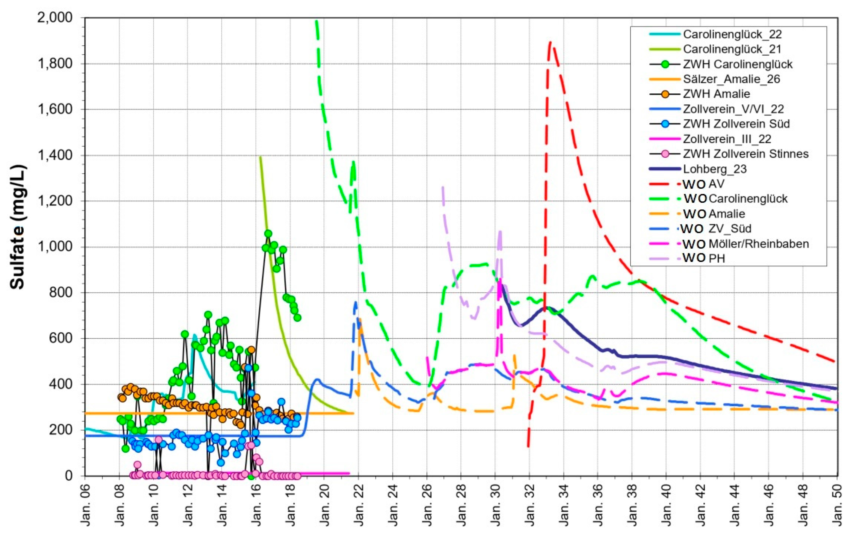
- Sulfate:
In order to study the contaminants mobilization and transport, the development of sulfate in the mine water plays a major role, since the mobilization of sulfate from pyrite oxidation in the water rise has a crucial effect here. Sulfur, as the main component of pyrite (FeS2), is especially affected by the oxidation process and the subsequent dissolution of the resulting salts and appears as sulfate in the mine water. In Fig. the concentrations of sulfate in the central water province are presented. Sulfate concentrations show clear peaks after flooding, then decrease exponentially due to exchange of mine water in the post water-rising phase. Figure 9 shows that the highest SO4 contents appears in the south part (WÜ Carolinenglück with a concentration of ~2 g/L). This is due to the seepage waters from the surface in which a higher amount of pyrite oxidation has happened. In contrast, low concentration of sulfate are observed in the central Emschermulde (Zollverein, SO4 < 50 mg/L). This is because of a high content of barium in the deep inflows and consequently precipitation of barite and decrease of sulfate in the mine water. Barium is a constituent of saline waters, accompanied by radium in a very constant ratio. Barium sulfate precipitates quite rapidly when a water containing-barium mixes with sulfate-containing waters. Barium can also serve as an indicator of radioactive contamination by radium 226 and radium 228, which are also present in the precipitated barium sulfate due to correlated co-precipitation of radium. Conversely, sulfate-containing waters in the south are barium-free. The overall balance after water rising is a sulfate-containing barium-free mine water with no treatment requirements for barium/radium.
Figure 9.
Simulated (lines) and monitoring data (symbols) of sulfate concentration in the central water province.
Figure 9.
Simulated (lines) and monitoring data (symbols) of sulfate concentration in the central water province.
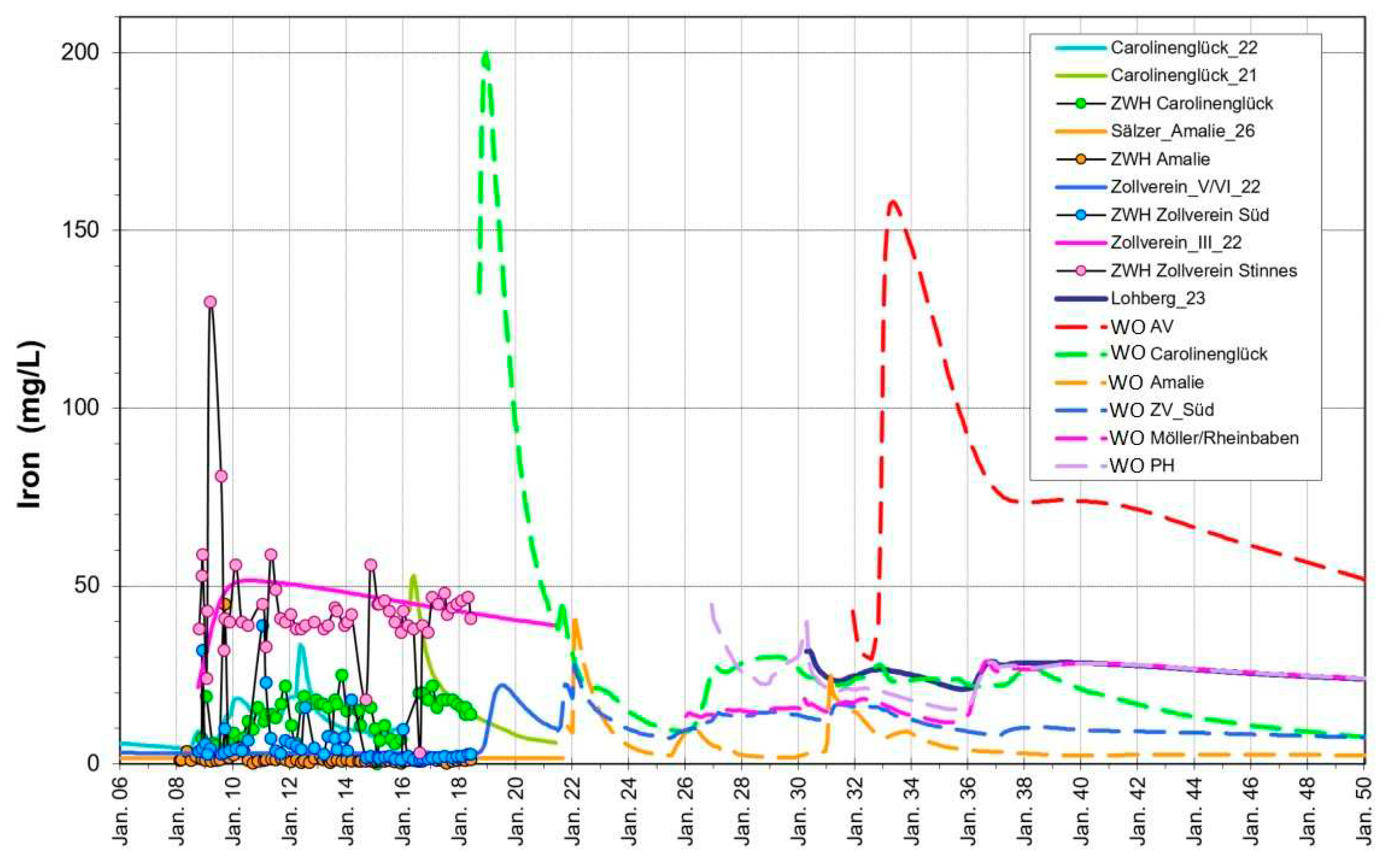
- Iron:
As the second main component of the pyrite oxidization, iron is mobilized in the water rise. This process is analogous to sulfate and can preferably be recognized in the Carolinenglück and AV/Lippe province (Figure 10). In principle, however, it can be assumed that iron mobilization is a universal process. On the basis of iron it is found that the flushing of the substances present in the mine water after the water rise in the deep Emschermulde is very slow (the inflowing water contains in the mixture 13 mg/L). A large volume of impounded water is replaced from small inflow rate quantities here. The Carolinenglück province reacts disproportionately more dynamically to hydraulic changes. The highest primary iron concentrations come from the Auguste Victoria mine. In addition, due to the mineralization, high material inputs are also to be expected from this area in the future. In the overall mixture, iron levels of between 20 and 40 mg/l can be expected upon discharge. The extent to which this is compatible with the limit values in the receiving river Rhine must be the subject of corresponding investigations.
Figure 10.
Simulated (lines) and monitoring data (symbols) of iron concentration in the central water province.
Figure 10.
Simulated (lines) and monitoring data (symbols) of iron concentration in the central water province.
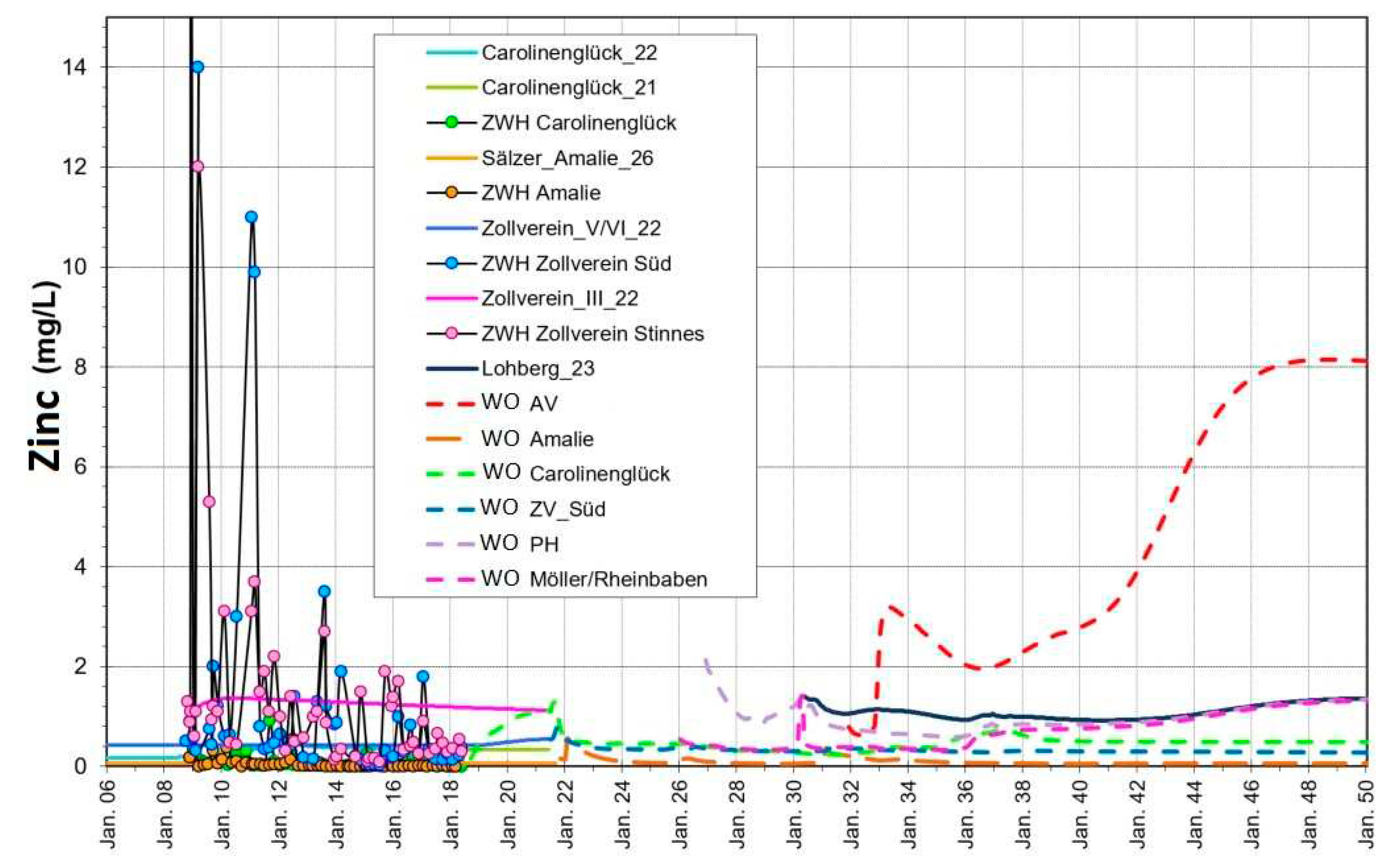
- Zinc:
Metal contamination in the mine water is the most severe problem and has been reported in many mining regions worldwide. Zinc is one of the most abundantly found metals in contaminated mine waters. Zinc contents in the central water province fluctuate frequently as can be seen in Figure 11. A mobilization analogous to iron from pyrite oxidation can be assumed for zinc in the water rise. Observations imply that, in addition to zinc, nickel and copper are also mobilized from pyrite or as a result of pyrite oxidation. At the Auguste Victoria mine (WÜ AV) the pH value is lower compared to the other provinces, mainly due to the inflows from the previously mined mineralization zone and its subsequent flooding. This is expected to result locally in an unusual high concentration of zinc. However, this zinc hot spot influences the water quality of the entire area and represents the greatest impact for future discharge.
Figure 11.
Simulated (lines) and monitoring data (symbols) of zinc concentration in the central water province.
Figure 11.
Simulated (lines) and monitoring data (symbols) of zinc concentration in the central water province.
6.3. Simulation of PCB Transport
Like other high-molecular organic compounds, PCB has a very low solubility in water and a high tendency to bind to particle surfaces, therefore it can be transported in a high content on particles [17]. Numerous investigations have shown that this is also the case in mine water. The Boxmodel was therefore upgraded for the particulate transport of PCBs, but would in principle also be able to take dissolved PCBs into account. According to this modelling approach, PCB levels in mine water are essentially a result of the suspended matter content in the water and the PCB concentration of this suspended matter [4]. In contrast to soluble species, the solid particles are eroded in turbulent water flow and accumulated again at low flow velocities.
The concentrations calculated from inflows, water flow in the mine and finally the rebound mine water are influenced by the mining conditions and the corresponding inputs of the different particle types:
Particles containing PCB, whose mobilization and transport behavior are considered in the model.
PCB-free particles, which are also taken into account with fractions in the model.
The relationship between the two particle types results from the area ratio of the respective mining elevation (PCB use (1964-1991) or PCB free) in the various hydraulically connected levels.
The model calculates a mixture of the particle contents transported by the inflows during the water rebound and mobilized by additional erosion. In general, the reduction in the particle content after flooding by diminution of turbulent flow and increased laminar flow in now the water-filled galleries leads to a significant decrease in PCB concentration [23].
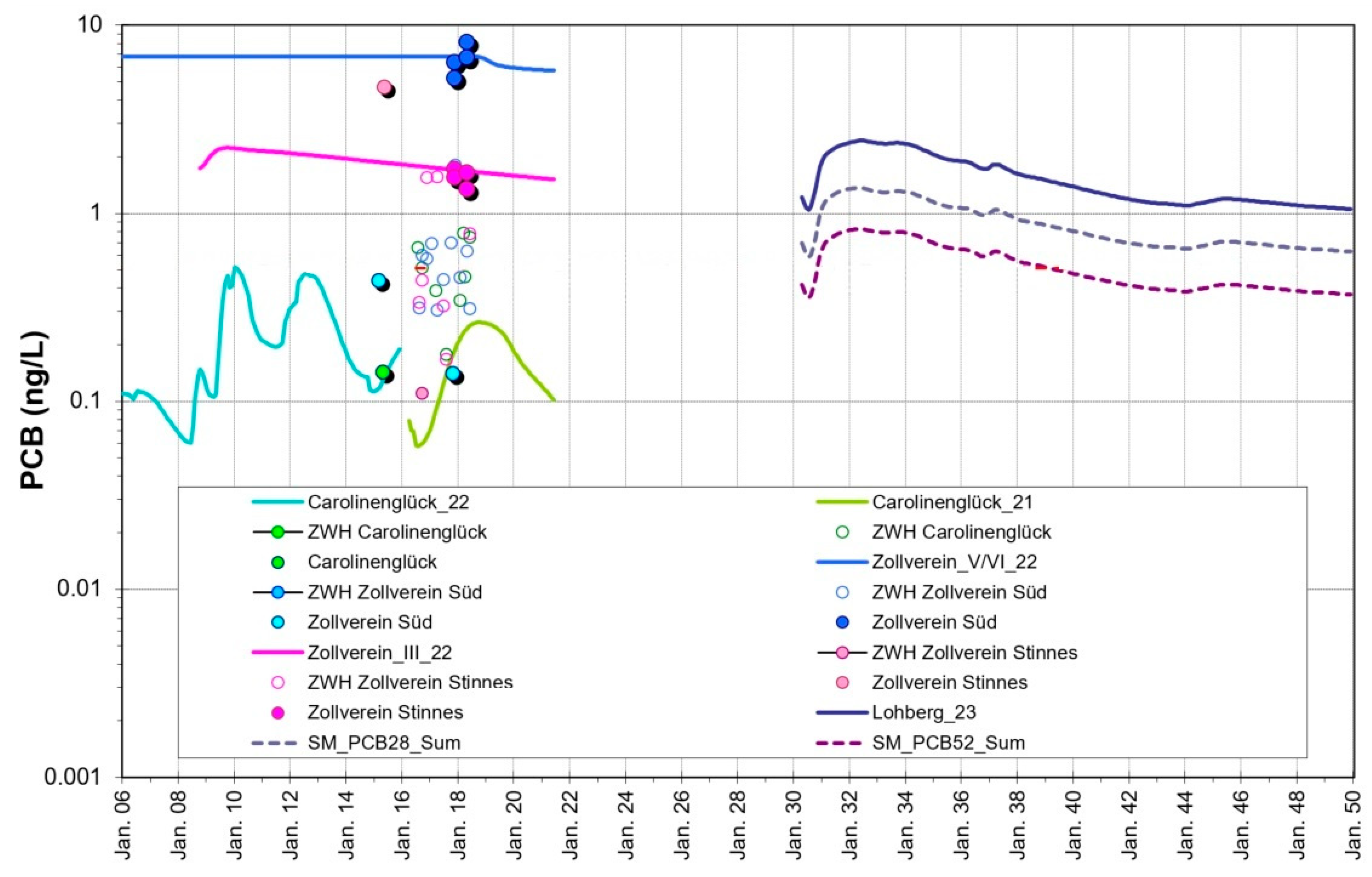
Fig. shows the PCB concentration in the central water province. Results show a wide spread in PCB contents of the mine waters in the sub-provinzes. This is due to the spatial heterogeneity in the remained PCB in underground mines from the mining activity period.
In standard analysis 7 PCB-congeners are determined as representative indicator compounds which are also considered as separate substances in the Boxmodel. The chemical properties of the different PCB congeners depend on the chlorine content [19]. Due to the nature of the PCB-containing liquids used in mining, besides the sum of the 7 congeners the PCB-28 and PCB-52 as main components are of particular importance. The analytically determined particle levels of a few mg/L and PCB levels in the solid of several 100 mg/kg result in particle-bound concentrations of a few ng/L, which nevertheless can represent a relevant load when discharged into the receiving water, especially immediately after pumping has started.
Figure 12.
Simulated (lines) and monitoring data (symbols) of PCB content of the particulate solid in the central water province of Ruhr area.
Figure 12.
Simulated (lines) and monitoring data (symbols) of PCB content of the particulate solid in the central water province of Ruhr area.
6.4. Monitoring and Water Treatment
In general the qualitative and quantitative monitoring data of inflows and pumped mine water is an essential tool for model calibration and predicting a long-term mine water drainage. This made it obvious that mine water contains various contaminants or even natural components that can become a pollutant when discharged into a surface water. For this reason, the question of a possible water treatment must always be considered in planning for a water rise and subsequent dewatering.
In result of the water rise due to stopping the water-pumps, the monitoring water quality through regular sampling of this water is inapplicable. During the mine water rise the hydraulic situation is changing, and depending on the distribution of inflow rates and the fillable residual void volume, the flow conditions in the mine change constantly until activation of a new pumping level and/or location are re-established. In order to obtain knowledge about the condition of the mine water outside the remaining water elevation points under these conditions, extensive monitoring is already being carried out by RAG in shafts that have access to the mine water. In addition to measuring water levels, this also includes taking and analyzing water samples. This is necessary in order to know a possible need for water treatment in general or to determine its urgency and extent.
The necessary access to the underground mine is provided by shafts and boreholes. Mine water samples must meet several conditions to allow a representative conclusion on the underground conditions. The basic requirement is that the sample be taken outside the guide pipe in which the sampling vessel is lowered. The sampler must therefore enter the free shaft and be opened there at a defined level. This location must also be chosen in such a way that its position in the flow is known on the one hand and that it also represents a relevant mine water flow.
Based on the monitoring data and the results of the calibrated models, the requirements of suitable mine water treatment plants will be evaluated. Depending on the situation, different goals are relevant. These include the metal- or sulfate-containing waters described in Chapter 5.2, but also PCB, radioactivity or the salinity of the water.
In the past, mine water treatment in the German hard coal mining industry was only carried out to a limited extent and in some cases underground. One exception is the Ibbenbüren site, where acidic water with a high metal content has been treated for many decades. Mine water drainage in the past also benefited from the fact that large parts of the mine water were discharged into the Emscher river, which had been converted into a wastewater canal. Now that the Emscher has been re-naturalized, the hurdles for the discharge of mine water have increased. Limits for discharge of mine water into surface rivers are specified in the Federal Water Act and in the Surface Water Act, which have adapted the specifications of the Water Framework Directive. If these limits are exceeded in the future, water treatment for the pollutants contained in the mine water (whether from anthropogenic waste materials, substances mobilized from the rock by mining, or from natural sources) is a suitable option for environmentally safe discharge. The technology used, but also the targeted capture rates, must always take into account the usually high flow rates of the mine water, which in the case study described sum up to more than 45 m³.
For the following mine water components at different locations a requirement of treatment have been identified and the methods for reducing the concentration have been applied, tested, developed or examined:
- -
- Iron and metals
- -
- sulfate
- -
- salts
- -
- Barium/radium
- -
- Hydrogen sulfide
- -
- PCB
In principle, different methods are available to remove waste material contaminants from mine water. However, in some cases the effort is very high (e.g. desalination, sulfate, PCB) and aspects of proportionality have to be considered. In some cases, however, the necessary adaptation of the process to the conditions of the mine waters is still missing (e.g. PCB). Model prediction has proven to be the most important tool for the planning of such concepts, as only it can provide a basis for the expected substance contents. After all, planning, approval and construction of such a plant always require a lead time of several years.
2. Conclusion and Suggestions
Understanding the interaction of different types of waste materials in underground mines with rising mine water is of great environmental importance. Uncontrolled mine water level rebound may result in pollution of drinking water resources due to the mine water contact with wastes or natural substances that impair water quality. In coal mining from last centuries the use of flame resistant material PCB/PCDM together with the backfill materials are two major sources of anthropogenic wastes. In case the backfill material contains metals it must be ensured that these are not mobilized during flooding process, specifically when the pyrite oxidation has the potential to reduce the pH of the mine water. In addition, mineral oil products have been used for underground machine operation for many decades.
Simulation of hydrodynamics and hydrogeochemical processes occurring during the mine water rebound can reduce the risk of surface and ground water contamination and prevent environmental hazards. In this regard, the DMT Boxmodel has been developed and introduced, which predicts the effects of mine water level rise and the associated hydrogeochemical processes in a large complex underground mining area. It has been successfully applied in several mining regions in Germany and worldwide.
Modelling results provided by the Boxmodel for the central water province of Ruhr area predicted the mobilization and transport of contaminants in the mine water during and shortly after the mine water rebound. Intensive monitoring and controlling the water quality and quantity in inflows and mine water is an essential tool for model calibration and predicting a long-term mine water drainage. Based on the monitoring data and the results of the calibrated models, the requirements of suitable mine water treatment plants will be evaluated.
So far, the RAG and the RAG foundation have successfully undertaken substantial efforts to ensure drinking water quality. The use of contaminant transport modelling with the DMT Boxmodel has provided the baseline for successful water management.
References
- Gombert, P.; Sracek, O.; Koukouzas, N.; Gzyl, G.; Valladares, S. T.; Frączek, R.; Klinger, C.; Bauerek, A.; Areces, J. E. Á.; Chamberlain, S.; Paw, K.; Pierzchała, Ł. An Overview of Priority Pollutants in Selected Coal Mine Discharges in Europe. Mine Water Environ 2019, 38, 16–23. [Google Scholar] [CrossRef]
- Claxton, A.; Ganguly, A.; Her, S. Web Page: Global Coal Mine Tracker. https://globalenergymonitor.org/ (accessed 2023-06-23).
- Struckmeier, W. Forum Bergbau Wasser. https://forum-bergbau-wasser.de/ (accessed 2023-06-23).
- Klinger, C.; Eckart, M.; Löchte, J. Integration of Solid Matter Coupled Contaminant Transport into the 3D Reactive Transport Boxmodel by the Example of PCB in German Hard Coal Mining. In Mine Water and Circular Economy, IMWA 2017; Lappeenranta, Finland, 2017; pp 1–9.
- Donovan, J.; Karfakis, M. Underground Disposal Of Coal Waste For Enhanced Ground Control And Recovery; 2007. https://www.researchgate.net/publication/340388742.
- Yin, Y.; Zhao, T.; Zhang, Y.; Tan, Y.; Qiu, Y.; Taheri, A.; Jing, Y. An Innovative Method For Placement Of Gangue Backfilling Material In Steep Underground Coal Mines. Minerals 2019, 9. [Google Scholar] [CrossRef]
- Klinger, C.; Eckart, M.; Rüterkamp, P.; Steinmetz, T. Einfluss Eines Wasseranstiegs Durch Einstellung Der Wasserhaltungen Zollverein, Carolinenglück, Amalie Und AV Auf Die PCB-Und Sonstige Stoffgehalte Im Grubenwasser INHALTSVERZEICHNIS Seite; 2019.
- Pohl, W. L. Economic Geology; Schweizerbart Science Publishers: Stuttgart, Germany, 2020. [Google Scholar]
- Wang, Z.; Xu, Y.; Zhang, Z.; Zhang, Y. Review: Acid Mine Drainage (AMD) in Abandoned Coal Mines of Shanxi, China. Water, 2021. [Google Scholar] [CrossRef]
- Wood, S. C.; Younger, P. L.; Robins, N. S. Long-Term Changes In The Quality Of Polluted Minewater Discharges From Abandoned Underground Coal Workings In Scotland. Quarterly Journal of Engineering Geology 1999, 32, 69–79. [Google Scholar] [CrossRef]
- Lambert, D. C.; McDonough, K. M.; Dzombak, D. A. Long-Term Changes In Quality Of Discharge Water From Abandoned Underground Coal Mines In Uniontown Syncline, Fayette County, Pa, Usa. Water Res 2004, 38, 277–288. [Google Scholar] [CrossRef] [PubMed]
- Kessler, T.; Mugova, E.; Jasnowski-Peters, H.; Rinder, T.; Stemke, M.; Wolkersdorfer, C.; Hilberg, S.; Melchers, C.; Struckmeier, W.; Wieber, G.; Schafmeister, M. T. Groundwater In Former German Coal Mining Areas—a Scientific Perspective On Mine Floodings. Grundwasser 2020, 25, 259–272. [Google Scholar] [CrossRef]
- RAG. Konzept Zur Langfristigen Optimierung Der Grubenwasserhaltung Der RAG Aktiengesellschaft Für Nordrhein-Westfalen; 2014.
- van Berk, W.; König, C. M.; Schwarzbauer, J.-C.; Rüde, T. R.; Preuße, A. Gutachten Zur Prüfung Möglicher Umweltauswirkungen Des Einsatzes Von Abfall-Und Reststoffen Zur Bruch-Hohlraumverfüllung In Steinkohlenbergwerken In Nordrhein-Westfalen, Teil 2 Endbericht; Aachen, 2018.
- Bedford, M.; Markowska, M.; Kruczek, M.; Janson, E.; Wrana, A.; Skalny, A.; Łabaj, P.; Wrona, P.; Różański, Z.; Suponik, T.; Foster, P.; Zawadzki, P.; Klinger, C.; Pollmann, N.; Pach, G.; Niewiadomski, A.; Król, A.; Theocharis, A.; Deliveris, A.; Nguyen, P. TEXMIN HANDBOOK. A Guide to Managing the Risks Posed to Working and Abandoned Mining Facilities, and to the Surrounding Environment, Caused by Climate Change; Central Mining Institute (GIG), University of Exete, 2022.
- Klinger, C.; Pollmann, N. Konzept Zum PCB-Monitoring in Schächten Des Ruhrreviers; Essen, 2021.
- Bench, D. PCBs, Mining, and Water Pollution. In Mine Design, Operations & Closure Conference; Polson, Montana, 2003; pp 1–12.
- Coldewey, W. G.; Semrau, L. Mine Water in the Ruhr Area (Federal Republic of Germany); 2012. www.IMWA.info.
- Vogt, M. Machbarkeitsstudie Zentrale Wasserhaltung Lohberg März 2020; 2020. https://www.rag.de/fileadmin/user_upload/02_Loesungen/01_Wasserhaltung/Machbarkeitsstudie_Lohberg/Machbarkeitsstudie_Lohberg_Endfassung.pdf (accessed 2023-06-26).
- Eckart, M.; Gzyl, G.; Kories, H.; Metz, M.; Rengers, R.; Paul, M. Das Boxmodell-Konzept – Von Der Modellbasierten Flutungskonzeption Des Wismut-Standorts Ronneburg Zur Anwendung in Der Deutschen Steinkohle. In Internationales Bergbausymposium WISMUT; 2007.
- Eckart, M.; Klinger, C.; Dennis, I.; Dennis, R. Coupled Reactive Mass Transport For The East Rand Basin (Rsa). In IMWA 2016. Mining Meets Water – Conflicts and Solutions; Freiberg-Germany, 2016.
- DMT GmbH & Co., KG. BoxModel Concept: ReacFlow3D Modelling of the Flow of Mine Water and Groundwater, Mass and Heat Transport Program Description BoxModel Concept: ReacFlow3D CAD System: BOXCAD Pre-Processor: PRAEBOX Box Model: BOX3D; 2011. www.dmt.de.
- Klinger, C.; Eckart, M.; Rüterkamp, P.; Steinmetz, T. Einfluss Eines Wasseranstiegs Durch Einstellung Der Wasserhaltungen Zollverein, Carolinenglück, Amalie Und AV Auf Die PCB-Und Sonstige Stoffgehalte Im Grubenwasser; 2019.
Figure 1.
Location of the Ruhr area in Western Germany and Ruhr mining region.
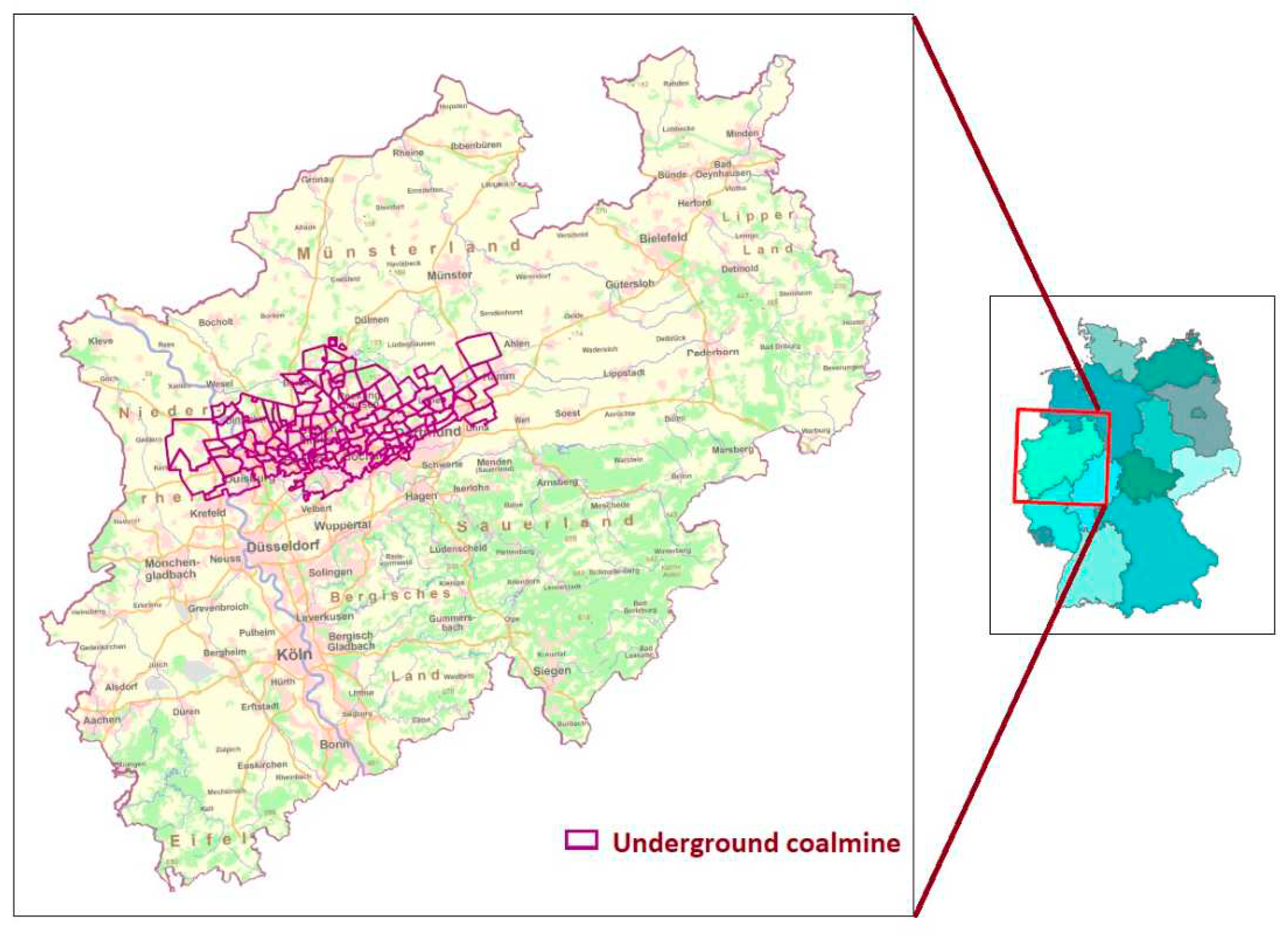
Figure 2.
Mine water management concept of the RAG (predicted situation in ~2035; source [19]).
Figure 2.
Mine water management concept of the RAG (predicted situation in ~2035; source [19]).
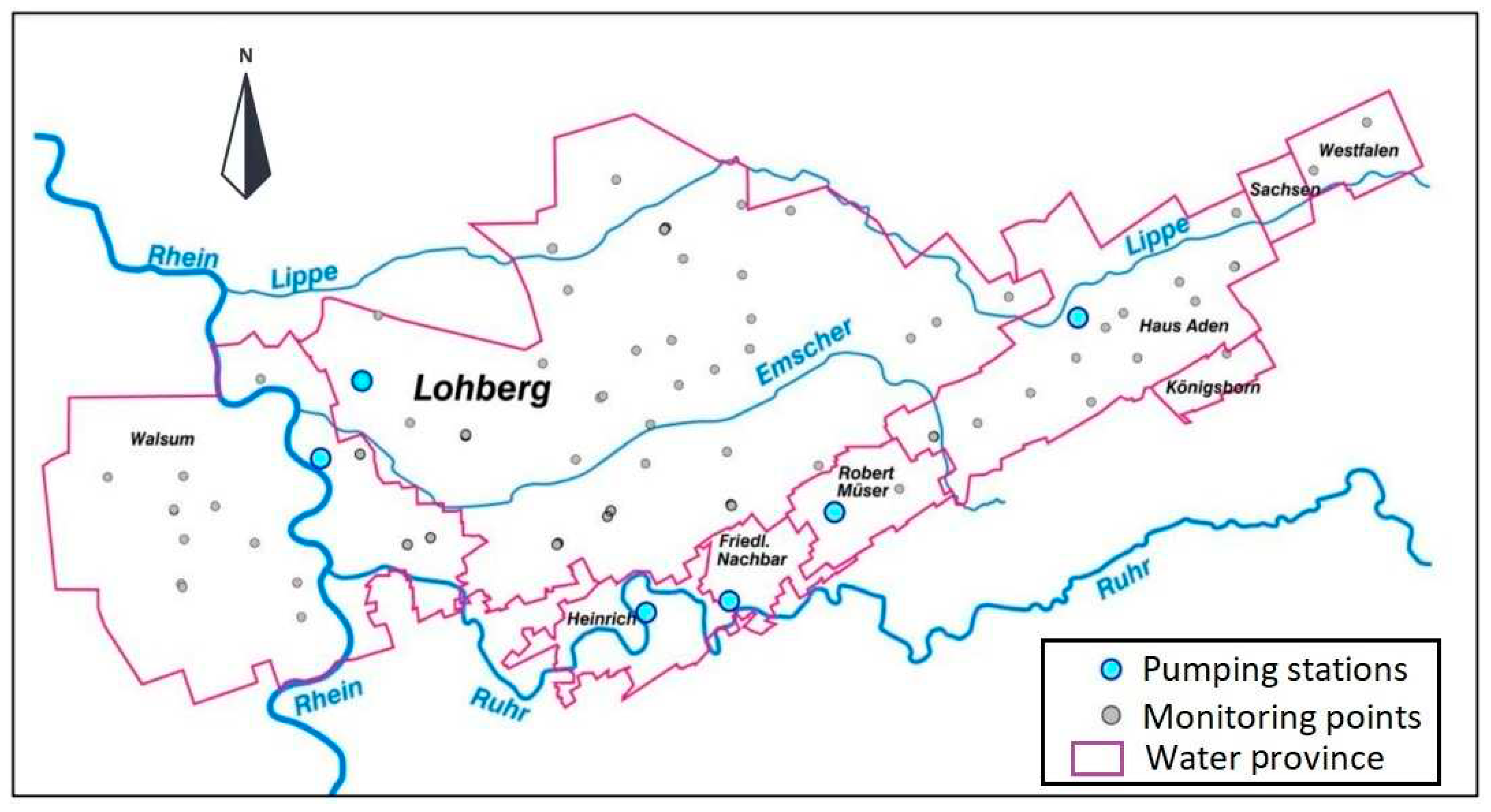
Figure 3.
2D view of Boxmodel of Ruhr area located in North-Rhine Westfalia and the central water province (filled boxes in purple). (Zoom in to Figure 1).
Figure 3.
2D view of Boxmodel of Ruhr area located in North-Rhine Westfalia and the central water province (filled boxes in purple). (Zoom in to Figure 1).
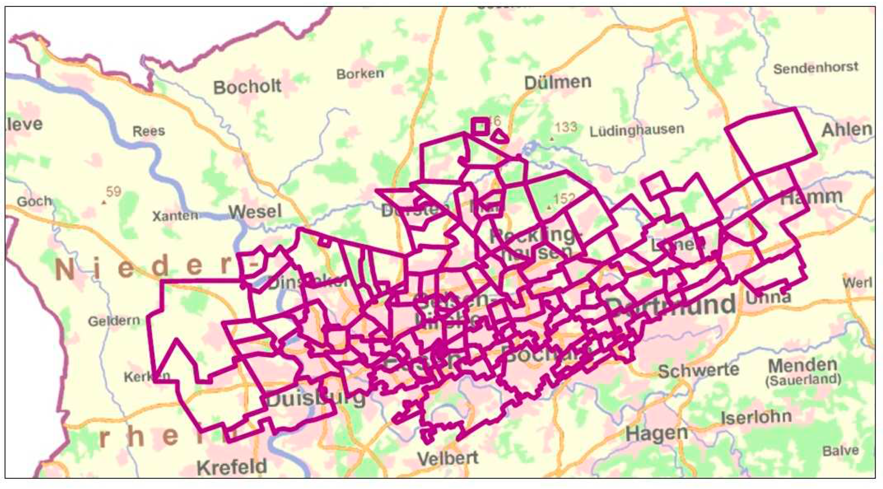
Figure 4.
3D view of Boxmodel of Ruhr area including hydraulic connections. Total area of all boxes is 2461 km².
Figure 4.
3D view of Boxmodel of Ruhr area including hydraulic connections. Total area of all boxes is 2461 km².
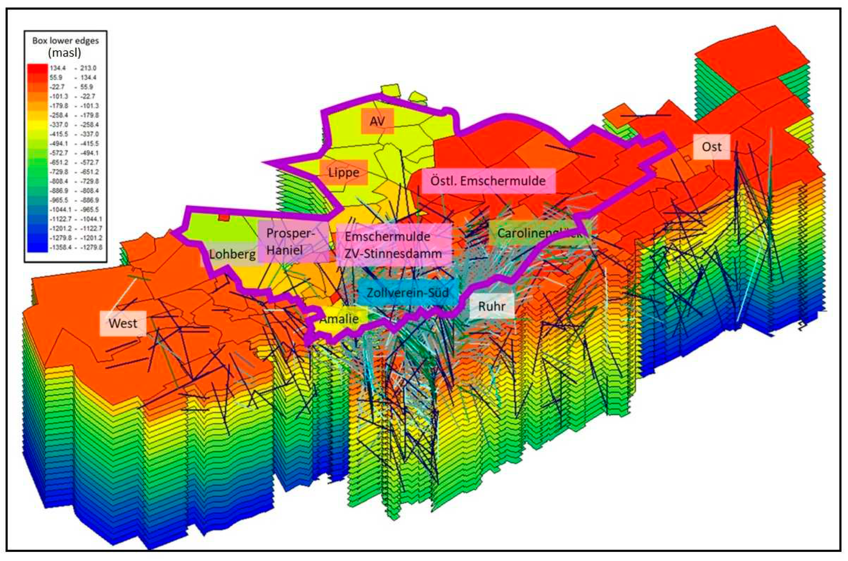

Table 1.
Types of wastes/contamination sources in underground coalmines.
| Waste | Types of contamination | |
|---|---|---|
| Geogenic sources of pollution |
|
Pyrite oxidation products, (metal contamination, acidic mine water), high saline water, Radium 226 and 228 |
| Anthropogenic wastes |
|
Petroleum hydrocarbons, PCB, PCDM, metals, |
Table 2.
water provinces and pumping stations.
| Main Water Province | Sub Water Provinces (larger units) |
Central Pumping Station |
|---|---|---|
| West | West, Walsum, Concordia | Walsum |
| Central | Amalie, Emschermulde, Zollverein, Prosper-Haniel, Lohberg, Carolinenglück, Lippe, Auguste Victoria | Lohberg |
| East | Hansa, Haus Aden, East | Haus Aden |
| Ruhr | Robert Müser, Friedlicher Nachbar, Heinrich |
Disclaimer/Publisher’s Note: The statements, opinions and data contained in all publications are solely those of the individual author(s) and contributor(s) and not of MDPI and/or the editor(s). MDPI and/or the editor(s) disclaim responsibility for any injury to people or property resulting from any ideas, methods, instructions or products referred to in the content. |
© 2023 by the authors. Licensee MDPI, Basel, Switzerland. This article is an open access article distributed under the terms and conditions of the Creative Commons Attribution (CC BY) license (http://creativecommons.org/licenses/by/4.0/).
Copyright: This open access article is published under a Creative Commons CC BY 4.0 license, which permit the free download, distribution, and reuse, provided that the author and preprint are cited in any reuse.


