Submitted:
23 June 2023
Posted:
26 June 2023
You are already at the latest version
Abstract
A geophysical technique termed Electrical Resistivity Tomography was applied to identify potential groundwater-bearing zones around Nubutautau village within Viti Levu Island of Fiji. Apparent resistivity data of the subsurface were collected through the electrode assembly along survey lines by injecting current into the subsurface using the ABEM Terrameter LS2. True resistivity data were simulated using the Res2DINVx64 software to produce the final electrical resistivity profiles through an iterative process. Analysis of the resulting modelled profiles revealed the presence of two potential groundwater-bearing zones as potential targets for future drilling. The two targets indicated the presence of potentially saturated vertical fractures through which infiltrating rainwater percolates through the volcanic rock towards a deeper basal aquifer. The identification of the two potential targets demonstrated the great potential of this geophysical technique to effectively inform drilling operations through an evidence-based approach to increase the successful delivery of water security interventions in remote, drought-prone communities of the Pacific.
Keywords:
Groundwater
; Hydrogeology
; Resistivity's
; Conductivities
; Hydrology
1. Introduction
The field geophysical technique provides a pre-assessment to the groundwater drilling work in making decisions on multiple platforms such as technical, economic and social, for the development of the groundwater resources. Groundwater is an alternative source of water supply other than the systematized treated scheme for most communities globally and it is still expanding boundaries in many facets of the development and implementation stages (Goldman & Neubauer 1994; Hasan et al. 2018; Islami et al. 2018; Saad et al. 2012; Siemon et al. 2009). The harvesting groundwater through multiple geophysical methods has been developed well over the years with the usage of electronic-based instruments and consistent up-gradation of the technologies. The resistivity survey method is an instrumentation approach to analyze the geological profiles with the resistivity range, leading to interpretations to locate the best water-bearing zones through the comparison of resistivity values. The resistivity is one of the most understood parameters from which multiple inferences can be made such as a pre-drilling assessment of water boreholes, locating the buried objects such as metallic pipes and leaks, identifying the aged boundary pegs and locator, classifying and identifying different rocks within the geological layers with the resistivity values (Houze Jr et al. 2012; Palacky et al. 1988; Ungureanu et al. 2017; White et al. 2008).
Groundwater sources are severely used in many parts of the globe, due to their major advantages of being less prone to be affected by the drought, than in comparison to the systemized and surface water. The advantages of groundwater range in many aspects such as consistent temperature, widespread availability, limited vulnerability, excellent natural quality, low cost of development, and drought reliability. Other qualities of groundwater over surface water are, it is less affected by disasters and can be exploited when needed (Sikakwe 2018). Effect of drought on the groundwater may result in a temporary decrease in the groundwater table, which may have a lesser yield on the discharge in comparison to dams or the natural rivers.
Case studies carried out in Nigeria revealed the success of the geophysical resistivity exploration in locating fractured weathered zones which have been the major groundwater development points (Abdullahi et al. 2014; Ariyo & Adeyemi 2009). Studies carried out in India on sites such as Maheswaram watersheds, in Andhra Pradesh using multiple electrode systems have further proved a success in locating the water-bearing zones (Dutta et al. 2006). Researchers in southwestern Pacific countries such as New Zealand which has got many potential aquifers near the Canterbury have also used the same methods for the groundwater exploration survey to locate the water occurrences, rechargeability through the data interpretational tasks (Cox et al. 2012; Zohdy et al. 1974).
Regional groundwater works have been carried out by the Secretariat of the Pacific Community (SPC) all through the usage of the geophysical techniques, to assist the small island developing countries. This includes the works carried out in Vanuatu, after the passage of the tropical cyclone ‘Pam’ as a form of providing recommendations to the development of the bore drilling (Antoniou et al. 2017). Furthur works in strengthening water resilience have also been done in certain other regional countries such as Kiribati, Solomons to ensure the expansion of the water resources. Locally, water assessment investigations through the geophysical platforms have been run by the SPC, in the western part of the Viti Levu, Fiji, in the province of Ba and Rakiraki, as a response to the tropical cyclone recovery program. This program focused solely on the hydrogeological assessment of the groundwater through resistivity methods (Antoniou et al. 2018b).
In this paper, groundwater investigation has been carried out in the Nubutuatau village, Fiji, to explore the possibility of the potential water-bearing zones for the implementation of the water development in the local community.
2. Materials and Methods
2.1. Site Description and Geology
Nubutautau village is situated in the interior of the Viti Levu island of Fiji towards the inner highland as shown in Figure 1. Nubutautau location has interesting underlying geology which falls closer to the sharp boundary that divides the two different geologies across the Viti Levu. Previous geological mapping and classification suggest the covering of the eastern part of the boundary is composed of thickly and thinly bedded sandstone, greywacke and basal conglomerate, whilst the western part is covered by undifferentiated basaltic flows of the Ba volcanic group, both these rock types classification falls in the volcanic groups (Loco et al. 2020). The geology of the Nubutautau of the underlying Vatukoro greywacke materials as it was falling on the western part of the boundary which has sandstone with minor basalt and limestones. The Vatukoro greywacke was deposited in a series of smaller sub-basin from the erupting volcanology (Stratford & Rodda 2000). Crystallic volcanic mafic sandstone has been overlying certain other geologic features such as fractured uplift shales and siltstone (Loco et al. 2015). Most of the exposed parts of the geology have been weathered away due to the heat and the convective activity as exposure to the tropical conditions (Hopkins 2011).
2.2. Field Assessment
The field site was first assessed through the lineament analysis using the google earth satellite tool. The analysis was used to view the orientation, topology, known structural faults. Further, it required connecting points of the abrupt changes through geological features where the same orientations were observed as shown in Figure 2. Three major lineaments were identified using Google Earth satellite imagery to match similarity in the features. Two of the lineaments were parallel having an SW-NE trend and one with an S-N trend, which was directly in line with a perennial spring located south of the village and discharges straight into Sigatoka River (Loco et al. 2020). The second stage of the assessment was based on the physical inspection of these zones picked by the lineament map, which required moving through the bushes, valleys, and mountains to assess the physical topography. This stage of the inspection was necessary to match the lineament analysis map and inconsistencies with the physical topological features. A better view in terms of the precise details about the topography provides a good analysis of existing features such as the perineal and the intermittent creeks, dikes, the ground slopes, and the type of soil drainage with soil density (Raqona et al. 2020; Ghosh et al. 2021). The analysis through the inspection of the target areas to work within was followed by the experimental setup, which required the assembly of the instruments with the specified procedure.
2.3. Experimental Set-up
The basic principle of operation in electrical resistivity methods is the injection of direct current (DC) into the ground using a pair of current electrodes. The voltage measured is converted into an apparent resistivity value for further interpretations. Different types of soil and geological formations have different corresponding resistivity responses as a function of the soil and rock depth such as porosity, permeability, ionic charges of pore fluids and clay mineralization. The resistivity was measured within different zones based on the lineament maps and physical assessment of the ground. The ABEM Terrameter LS2 resistivity set-up consisted of four electrical cables rolls, each with 21 electrode takeouts positioning jumper connecting slots 5m apart. The ‘roll-along’ technique was used to create seamless profiles longer than the four-cable spread along the survey lines. The resistivity method was used through the Multi-Gradient Electrode Array (MGEA) assembly which stands as the electrode configuration to cover the selected zones. The major advantage of MGEA assembly is the favorable response of a good signal-to-noise ratio and better resolution to horizontal and vertical structures. The MGEA assembly captures the geo-electric data and performs self computation through the loaded programme and stores it in the memory device later retrieved for simulation work (Dahlin & Zhou 2006; Okpoli 2013). In Total components of the resistivity set comprised of 81 electrodes, 4 sets of cable rolls of approximately 100-110m in length, ABEM Terrameter LS2 known as the resistivity device, Garmin67 for manual coordinate locations recordings, surveying aerial (moving and the stationery rover), survey tape, walkie talkie device, sub connection cables or jumper cablings, cable connectors and 12V battery power supply.
The experimental set-up was of 5 survey lines required positionings of an ABEM Terrameter LS2 termed as a station, which had 4 channels in operations connected to the cables overlaying the zones of the survey. Each cable was approximately 110m in length and was divided into segments of 5m intervals, from which the jumper sub connections were done to the electrodes as a point of injecting current. Electrodes pegs were of the length of 0.4m length with stainless steel materials to disallow any corrosion leading to the impurity of chemical reactions which may lead to the pseudo anomalies in data. The ABEM Terrameter functioned as a mid-station accommodating an equal number of cables to be laid on each side, typically cables that were on the left and right connecting to the station were termed as cable 2 and cable 3. Figure 3a shows the conceptualized diagram of 4 cable connections, the ABEM Terramter is placed in between cables 2 and 3. All 4 cables showed this general assembly set up for each new positions during the cable mechanics.
Each survey line had 20 electrodes which were injecting the current in the ground surface and receiving it back into the ABEM Terrameter LS2 in the memory storage device. The assembly of each cable with its sub connections to the electrode connections can be seen in Figure 3b. Cables 1 and 2 were on the left side of the ABEM resistivity device while cables 3 and 4 were on the right. The consecutive cables on each side were connected through a common electrode which was jumpered twice with dual sub connections from survey cables (Figure 4) and was classified as an overlapping electrode (Figure 3a) for the continuity of the cable. Each cable catered 20 electrodes for the current to be injected into the ground surface, the 21st electrode functioned as an overlapping electrode on which the overlapping of the two cables from each side was done. The cables were moved linearly through the cable mechanics along the path length of the ground till it covered the whole survey profile length, the mechanics required approximately 3-4 new positioning of the Terrameter LS2 device. The ABEM Terrameter LS2 records the ground resistivity values and converts them to the apparent resistivity which is later used by the Res2dinv64x software to produce the multiple iterations with the least error in the results.
2.4. Data and Analysis
The apparent resistivity data were self-computed by the ABEM Terrameter simultaneously while the field geo-electric data were being recorded as a measure of ground resistance. This was the processed data in terms of the device computation but still appeared in the raw form to be download on the hard drive for analysis by software. The files were in the DATs format which required codes and formatting to open and process (Cardoso et al. 2018; Loke 2016). Specialized licensed software was used for handling the high volume of raw information (data) to produce resistivity tomograms. Res2Dinv64x software was used to assimilate and integrate the elevation data from post-processed kinematics (PPK) picked up at 20m intervals with geophysical data from the ABEM Terrameter LS2 to capture the exact geological profile for 75m bgl. Certain technical steps through the software were executed, such as the applications of the cut-off factor to adjust and eliminate outliers, followed by model discretization, inversion and model refinement, to allow forward modeling and simulation. The volume of the data was reduced to the spacing electrode distance of half the value from 5m to 2.5m to accommodate the full data set for each of the profile lines. Statistical techniques were used to view the data graphically in terms of standard deviation and outliers, as a way forward for trimming is critically important to allow an efficient simulation within the software.
3. Results and Discussion
The five resistivity survey lines revealed variable responses as influenced by the underlying geological rock formations and level of saturation. A total of 4 contrasting layers/areas are identified.
- A very low resistivity layer, shallow depth down to 20 m (1-19 Ohm.m), identified as a low permeability silty loam or clay or weathered siltstone that is partly or fully saturated, resulting in a low resistivity response;
- A zone of low resistivity (20–30 Ohm.m) interpreted as fractured and/or weathered rock formation represented as a vertical or near-vertical feature, and expected to yield groundwater;
- A medium resistivity (31–99 Ohm.m); suggesting less weathered volcanic or sandstone formation may yield little to no groundwater; and
- A high resistivity at depth (>100 Ohm.m), suggesting the presence of unweathered high resistivity material, such as basaltic material, at the base was observed in Survey lines 4 and 5, indicating low to no groundwater potential at depth (Loco et al. 2020). The geophysical results displayed are in terms of the ERT along 5 survey lines as presented in Figure 5, Figure 6, Figure 7, Figure 8 and Figure 9.
3.1. Tomogram Observations
Survey Line 1
Survey line 1 was the first geophysical investigation carried out at the Nubutautau village for the geo-electric data collection, this was in the SW-NE direction Figure 2. The total distance the survey line covered was 500m in length. The survey line started from the lower point, that is on the lower hill and moved up slightly through the dry sedimentary volcanic rocks where significant topological features were found such as dried creeks, dikes etc. Figure 5 shows the tomogram of the first survey line 1 with the elevational topological features of the near ground surface which helped to match the significant features such as potential fractures formed by intrusive dikes associated with the volcanic exposed areas. The entire survey line from 0-480m showed low resistivity between the depth 1-1.5m bgl as a result of intense weathering of the top geological layers leading to the formation of thick overlying clays moist in nature. The clays have a higher ability to hold moisture content revealed through the lower resistivity values of 1-10 ohnm.m.
Most regions covered by survey line 1 showed a resistivity of 40-50 ohnm.m and greater within the full horizontal profile of 500m to a depth to75m bgl. This was classified as a medium resistivity, which in the geological log indicates some possibility of groundwater presence within the zone. A possibility of freshwater existence may be present but not fully indicative due to the equal distribution of resistivity. Portions of the survey lines with the depth extending as close to 25m bgl with the elevation of 568-598m msl revealed resistivity values ranging from 45-55ohm.m This could either be due to the compact and impermeable characteristics of basalts, which do not allow groundwater to be held within their pores. It is, therefore, quite probable that shallow low-resistivity zones near the ground surface contain some groundwater held within the clay by capillary forces (Antoniou et al. 2017).
The region ’X” in the tomogram,” shows a deeper and organized dimension with the portion of lower resistivity indicating a hydrological feature of the volcanic or lateral part of the basement aquifer in the confined zone. The defined enlarged region represented at point “X has a resistivity value of 30ohm.m at 25m bgl corresponding to the length of 240-280m within the survey line. The resistivity values of 30ohms indicate the weathered basalt with freshwater. In comparison to the other portions of the ERT for the same survey line, a significant shift in the resistivity values to a lower range reveals the possibility of existence for a water containment unit. Depiction of an obvious occurrence of the groundwater features corresponding to point ‘X’ near the ground surface within the survey range of 230-280m of the horizontal profile is obvious in the figure. The lower resistivity found at point X can be termed as a possibility of a confined aquifer with basaltic rocks and clays containing freshwater being revealed by a smaller portion of the adjacent aquifer captured in the ERT. This confined aquifer portion is being overlayed by a thick bed of volcaniclastic geological rocks and clays. Hydrogeological it is inferred that there is an existence of the main aquifer adjacent to survey line 1.
Survey Line 2
Survey line 2 was laid in the SE-NW direction orthogonal to survey line 1 intersecting at 285m (Figure 2). The tomogram showed a possibility of the groundwater presence as per the lower resistivity within the range from 320-360m shown in Figure 6 with the resistivity values ranging from 25-30ohm.m. The orthogonal direction was chosen to cross checkpoint X from survey line 1 with the hypothetical approach and assumption a part of the aquifer was captured but not fully indicated. Alternatively, it was also executed to verify if there was any other occurrence of the groundwater in a region of lower resistivity adjacent to survey line 1. Substantial groundwater accumulation with promising drilling potential was interpreted at 240–360m along the profile within the deeper half of the section to about 37.5-65m bgl as shown in the same figure. The resistivity range indicates gravels saturated with fresh water and weathered basaltic with freshwater present at the point. This revealed some interesting features with resistivity variation in the suitable range for groundwater development as labeled point Y on the tomogram. The lower resistivity represented by point Y is connected to Point X of the first survey line demonstrating a conceptualized ground water bearing containment unit in a volumetric 3D existence of the aquifer through the very low resistivity value of about 15-30ohm.m revealing a water bearing unit with the sharp boundary features. It is certain if the drilling is done at any point within the range 320-360m, a water table would be reached upon the drill rig reaching an average depth of 60-65m bgl. All the other regions within the survey line revealed a high resistivity of 45-55ohm.m reveals low conductivity geological elements like basaltic materials (Meyerhoff et al. 2014). Inferences about the water presence as detected and revealed by survey line 2, show a water-bearing zone may have higher porosity, storativity, and permeability within the confined aquifer, which may have a higher tendency to hold water and retain in large quantities and volumes (Ayenew et al. 2008; Bairu 2013; Huntley 1986; Sophocleous 1991). 340m point with the range 320-260m is suitable for the placement of target 2, as due consideration to avoid destructions to the vegetations near the adjacent perineal creek found closer to the endpoint of the survey line. It is possible during the future drilling of the point of interest at 340m locations, water extraction would be obtained upon the drill rig reaching the minimum depth of approximately 40-60m bgl.
The overlying layer from the near-surface of 0-50m bgl has a higher level of resistivity within 0-320 m along the survey line which consists of rock materials such as siltstone and conglomerates indicative of a drier zone with higher resistivity. Beyond the linear zone of 320 m of the survey line, the ground had a medium resistivity of 31-99ohm.m to a depth of about 25m bgl as revealed by the green color image. This suggests the water found within the 40-60 m depth is rarely from the precipitation and surface infiltration mechanism, due to the higher resistivity layers indicating the poor ground permeability from the near-surface point (Zhu et al. 2008). As seen in target 1, the location is close to the sharp vegetation boundary of the downward slope, which provides evidence and the indication of how the internal groundwater flow feeds this valley leading to rich vegetations boundaries (Chui et al. 2011). It is assumed the water found within the adjacent perennial creek was from the seepage of the aquifer picked by survey line 2.
Survey Line 3
Survey line 3 was located close to the village cemetery running from the E-SW direction of true North. The survey line was 400m in the length and was 0.5km from the village in the SW direction. The surface geological location along the line showed good clay and sand distributions within the first 100m zone from the starting point and the later part varied slightly from rocks to other volcanic materials. Most of the near-surface ground features showed the lower resistivity from 0-19ohms.m to a depth of 5m bgl for the entire length of the survey track due to the surface weathering of the rocks of the upper lying layer which accounts for efficient infiltrations and ground saturation (Kelly et al. 2011; Palacky 1988). The geological area consisted of the potential groundwater impoundment at the dikes which was near the fractured zone at a point of 80m. According to (Pryet et al. 2012), surficial expressions such as eruptive fissures and cones may indicate the position of subsurface dikes. Moreover, when cones are elongated or aligned topographically as observed in the study area, they are likely to reveal the presence of dike swarms (Acocella & Neri 2009). Eruptive fissures and cones may have resulted in some fracturing along their edges, which may allow groundwater to occur at shallow depths. The small zones revealing a lower resistivity beyond 160m onward had the near-surface groundwater movement flowing perpendicular to the survey line direction in the form of the dry creeks or dikes are termed as perched water (Kumar et al. 2016). The hill's existence in the form of an elevated plateau, adjacent to survey line 3, consisted of the village burial ground which contained hard volcanic rocks and sandstone materials exposed to weathering with poor vegetation. The rock featured exposed elevated plateau accounts for surface runoffs during severe weather conditions allowing water to flow down to the lower part and feeds into the region of 160-240m of the survey line. The rain infiltration through the surface runoffs catches and retains water keeping the clay moist and eventually feeds into the perched aquifer leading to surface interactions. Within the first 45m range, the lower resistivity indicates the water presence up to the depth of 15- 18m bgl, equating to 470m msl elevation. The survey range within the 60-120m as shown in Figure 7 indicates a deeper level of lower resistivity in terms of the huge lense of water due to the fractured feature of vertical passage for water movement to the surface. The fractured point accounts for the lower resistivity and water presence forming potential target point 2. From the 60-120m range, 85m point was assessed to be the best location with a lower resistivity of 0-19ohms.m with the elevation height of approximately 485m msl as shown in the same figure. This fractured zone present at the site was due to the uplifting of the ground geology from viscodynamic forces and compressional tension, horizontal stresses leading to the rock deformations and splitting (Bonatti 1978; Yang et al. 2015). The presence of high-resistivity, vertically oriented features cutting through the older volcanic deposits suggests recent volcanic activity, which has resulted in surficial, less-weathered volcanic deposits (Antoniou et al. 2018a).
Survey Line 4
Survey line 4 and survey line 5 were run in the same area and were in the perpendicular direction to each other. Survey line 4 was in the E-NW direction and was 400 m in total length adjacent to the location where the old borehole was installed. Survey line 4 was indicative of clay geological presence near the ground or on the surface as shown by the resistivity value of 5ohm.m (Figure 8). The thick clay distribution was mainly from the silty loam observed during the old borehole drilling within the depth of about 0-6m bgl, spreading linearly to a range of about 150 m of the survey line and then decreases in depth beyond 160m range. The old borehole was drilled at the location of 160 m, the well was poorly efficient in yielding a good rate of a water leak, before completely being dried out. Lithological changes within the depth profile of the borehole have been observed and documented by SPC (Loco et al. 2020), as shown in Table 1. This hydro-geologically suggests, a small amount of water obtained during the drilling, was in the existence within a certain range of the sub geological profiles through seepages from the other sources and this was separated by the impermeable rock layers (Winter 2000). Figure 8 reveals tomography of different layers with the lower resistivity values ranging from 20-25ohm.m from the surface to 20m bgl depth indicated by the pale blue indicator. This shows an interesting feature of multiple layers with the increasing trends of resistivity values lying adjacent to one another indicative of the possibility of permeability and non-permeability of existing water movements through different layers. The previous groundwater investigation at the north-eastern part of the village showed the underlying rock formation composed of siltstone up to 24 m of the survey range before a weathered and fresh basaltic unit was encountered between 24 to 51 m. The tomogram also shows the thicker layer of higher resistivity varying 100-200 ohm.m from 30-40m bgl, is interpreted as almost zero water occurrence. The bottom high resistivity from 40-75m bgl is accounted for the heavy basaltic rock with the resistivity of > 200ohm.m, which later channels into the Sigatoka river and forms a thick bed of basaltic pillow larva with interbedded siltstone and sandstone (Loco 2011). The groundwater potential along this survey line is not recommended.
Survey Line 5
Survey line 5 was run in a similar zone to survey line 4 and was run perpendicular direction intersecting survey line 4 at 180 m (Figure 2). This line was laid in the NE-SW direction and was the shortest profile with a length of 385m. The orthogonal direction was used to cross-check the possibility of any adjacent aquifer present from which water has been moving linearly towards the old borehole. The entire full profile of the survey line showed overlaying layers of thick clays, visible during the entire field survey work. As shown in Figure 9, the resistivity varied 20-25 ohm.m within the length of 0-80m detecting the presence of clay, silty sandstone and surface freshwater in the form of perched features of water seepage. The range length of 80-385m resistivity varied between 5-15ohm.m, at approximately 50m of the line was represented with the region of rich clay and presence of brackish water as there existed a small flowing creek and drain structure with little existence of water content. The water existence demonstrated was an indication of the surface water which is seen as a slight pigmented point at approximately 50m of the survey line on the tomogram. It also reveals a thin, shallow and unconfined groundwater body in existence, and is believed to be a localized perched aquifer overlaying low-permeability weathered lava flows, Beyond the depth of 14-75m bgl of the entire 385m survey range, the resistivity values increased gradually indicating the presence of zero water occurrences. The thicker bed of portion located at point “K” ranging between 120-280m and approximately 30m bgl reveals the presence of very high igneous metamorphic rocks such as the Basaltic material. This bed of rock continues at the deeper level within the geology of Viti Levu common to survey line 4, is seen outcropping in the Sigatoka River (Loco 2011). The possibility of any groundwater occurrences on survey line 5 was absent with zero recommendations for future drilling tasks.
The corresponding values of the resistivities of the geological ground materials can be equated to Table 2 based on the rocks and the sediment types which are present at the survey within 75m depth.
3.2. Hydrochemistry of Selected Aquifers
The presence of springs within the investigation area suggests discharge of dike-impounded groundwater, these springs were surrounded by large vegetations and thick clay layers. The investigations of having any links with the existing dikes compartments were impossible to assess.
Three nearby springs were visited to collect water samples to test the geochemistry and the hydrochemistry of the existing aquifers for the Nubutautau location. These springs found were representative of the area of survey zones with similar geological features, the springs were Nubutautau spring, Tauboto and Yavuilagi springs. Streams connecting from these springs were generally dry except during strong rainfall events and the unconsolidated colluvial deposits lying in streambeds act as infiltration areas for rainwater. All three springs showed similarity in the water constituents in terms of chemical composition. Ten chemical elements were tested to check the groundwater hydrochemistry charged by the chemical reactions of the rock water interactions passing through different passages within the aquifer. Table 3 shows the list of the chemical elements tested from all three springs with the amounts in mg/L. The laboratory analysis was done at the University of the South Pacific, Suva, Fiji at the Institute of Applied Science. Ionic charges obtained were the indicator of certain minerals present within the rocks which have broken into charges through the dissociation process. This process has yielded reactions within the geochemical aqueous medium in the splitting of the chemical components from compounds of minerals has been evident. The chemical composition of the spring water samples reflects mainly the interaction of groundwater with feldspars and plagioclase feldspars contained in the sandstone and the siltstone deposits and possibly the dissolution of the underlying basaltic rock. The relatively high silica (Si) and total dissolved solids (TDS) content is likely attributed to groundwater residence time within the sedimentary and volcanoclastic formations where plagioclase feldspar may have been weathered into kaolinite clay, releasing cations and dissolved Si into the groundwater. The release of Ca, Mg, Cl and Fe may also derive from the dissolution of basaltic rock contained in the weathered volcanoclastic rocks.
Elements constituents were all in close range to one another, this suggests the groundwater in the confined zones had no contamination from any external pollutant activity, due to the non-existence of chemical anomalies. It can also be interpreted, the three springs are from the common aquifers below the ground level (Magal et al. 2013). Water found within the same aquifer has similar chemical reactions due to the same exposure and the amount of time they have been passing over the rocks and the soil materials (Allen et al. 2010; Magesh et al. 2020). Reactions within the rock water interactions contain the cations and anions charges exchanged to form chemically different compounds. The conductivity or salinity of the groundwater samples indicates a moderate range, which further suggests water is acceptable to all purposes at a community level.
The chemical properties of the ground and the water represents the degree of reactions, which determines the quality of water in terms of the dissociated ions. The atmospheric precipitation of the rainfall allows certain C from the atmosphere to be dissolved which gets percolated in the ground surface picking up more C forming a weak solution of carbonic acid. Carbonic acids chemically dissolve in water changing the PH range to a lower scale forming an acidic property of the infiltrated water (Elango & Kannan 2007). In the cases of the acidity nature of the groundwater, the volcanic rocks act as a neutralizing agent to effectively buffer the acidity.
Porosity and permeability in geological materials depend on the openings related to scoria deposits, breccia zones and cavities between flows, lava tubes, fractures and lineaments (Singhal & Gupta 2010). Hydrogeological parameters such as porosity and hydraulic conductivity tend to fluctuate depending on hydrometeorological phenomena. Borehole yield in volcanic rocks typically depends on the rock type present based on other parameters such as well locations, topography and geological responses to the hydrometeorological elements. These aquifer properties can only be calculated from pumping test data which was beyond the scope of the survey (Antoniou et al. 2017).
3.3. Hydrogeological Assessment
The hydrogeological system investigated at the Nubutautau village has revealed a potential groundwater association with geological features such as dikes, intermittent and perennials creeks. The vertical feature investigated at Target 2 (Survey line 3) has shown an obvious indication of the groundwater moving up the fracture passage and water seeping out in the horizontal pattern to the near-surface points into the shape vegetation. Target 1 (Survey line 2) reveals the large shallow aquifer with a depth of approximately 37.5-65m bgl expected to hold a substantial amount of fresh groundwater. This target was found on the sloped terrain, starting from the upper point to the lower point towards the cliff and large valley river basin creek. It can be hydro geologically be conceptualized, water from the shallow aquifer moves towards the lower part of the survey line closer to the adjacent creek which holds water.
Low-permeability layers (weathered or massive volcanic) allow groundwater to be held between the dikes or fine materials in filling these sub-vertical features. Groundwater potential in these contacts may vary over space and time and will be dependent on the storage capacity of the sedimentary formation towards the weathered interface. It can be conceptualized through the lineament topological near-surface vegetation features, the existence of the other shallow aquifers present within the vicinity of the Nubutautau village and this may be compartmentalized with poor flows due to partitioning from vegetations and geological settings (Brooks et al. 2015).
From the drill log data of the old borehole mentioned in Table 1, it appears that fresh siltstone with minor fractures overlies a weathered volcanoclastic formation which gradually becomes harder with depth (Fresh basalt seen in survey lines 4 and 5. Groundwater occurrences within these units is likely controlled by the bedding of the sedimentary units as observed in the existing springs, and within the fractures and structures within the volcanoclastic units, as supported by the geophysical investigation conducted. The interface between weathered and fresh volcanoclastic formation extending around the area where survey lines 1,2 and 3 seem to be particularly suitable for the groundwater accumulation, as inferred by the survey. This formation, which is mainly composed of the sandstones and siltstones is likely thicker and much more weathered allowing for a higher degree of saturation, as inferred by the resistivity ranges observed and tabulated in Table 2.
The shallow aquifers are the elongated points from the deeper indwelling ground water-bearing units on which the interior of Viti Levu is placed. The hydrochemistry analysis also supports the conceptualized groundwater interactions with the surface seepage flows from the main aquifers below the ground levels. This generalizes water is contained in one single deeper unit and the targets are the elongated features that form the shallow aquifer (Fernald & Guldan 2006). The groundwater sampled in the Nubutautau indicates a different, probably slower and shallower flow path, involving the interaction with soils and volcaniclastic deposits, which are more effective in neutralizing rainwater acidity. This is probably associated with dike-impounded or perched groundwater exfiltrating through contact or breakslope spring. These types of springs are, therefore, good indications for the quality of groundwater bodies with a high potential for development.
4. Conclusions
The electrical Resistivity Tomography (ERT) technique was used to study the water-bearing zones and features through the resistivity methods using the Multi Gradient Electrode Array (MGEA) assembly. Resistivity variations along five survey lines near the Nubutautau Village within Viti Levu (island) in Fiji were obtained. The below ground level (bgl) features were studied and inferences about groundwater potential points are made. The MGEA assembly has proven to be reliable in terms of capturing a complete resistivity profile at depth levels for the target points as the pre-drilling assessment.
Based on the resistivity method, ERT technique and electrode array, two potential groundwater zones have been identified with significant features containing water for future drilling targets. These include:
- A low resistivity zone identified at survey line 2, from 320-400 m profile distance and at 40-60 m depths below ground level. It is suggested this may represent the presence of a fracture zone and may be part of a bigger SW-NE fracture zone adjacent to the site.
- A prominent vertical feature of low resistivity at survey line 3, from 65 to 125 m profile distance and from 20 m depth below ground levels extending down to 80 m depth, also indicating a groundwater bearing fracture zone and connected to a spring source.
- Both the targets are reliable and consistent with the near-surface topological and geological features in the yield of the water given the geological and hydrogeological interpretations.
Hydrochemistry assessment revealed the existence of a common aquifer at the Nubutautau location through the similarity in the water constituents. This aquifer is assumed to be huge and covers a wider area. The flow rates of the three springs had been dropping significantly, which is mainly due to the insufficient rain replenishment which accounts for dry conditions and the significant drop in the water table.
Future research investigations within the ground resistivity may involve the second stage of borehole implementation in which drilling of the targets could be carried out. This would involve further findings related to the hydraulic testing such as carrying out the pumping tests of the groundwater to check the efficiency of the aquifer yield, constructional methods of the borewell and the sustainability measures for a longer run. Furthermore, it would also require analysing the chemical constituents of the ground extracted water for portability in the community.
Funding
The custodians and the involved personels are thankful to the University of the South Pacific for provding the major reserch funding for the masters level student for water testing and other field expense. The reserch was also in the bilateral collaboration with the Secreatriat of the Pacific community for faciliatating as a major arm of the on field work, with the technical specialization and the technical expertise.
Acknowledgments
The authors are also thankful to the Secretariat of the Pacific Community (SPC), Department of Water and Geoscience division for providing the entire equipment, logistics and technical support for the field trip to collect the data. The authors are also thankful for financial support from The University of the South Pacific, Suva, Fiji, under which this work has been carried out.
References
- Abdullahi, M. G., Toriman, M. E., and Gasim, M. B. 2014. The application of vertical electrical sounding (VES) for groundwater exploration in Tudun Wada Kano state, Nigeria. International Journal of Engineering Research and Reviews 2: 51–55. [CrossRef]
- Acocella, V., and M. Neri. 2009. Dike propagation in volcanic edifices: Overview and possible developments. Tectonophysics 471: 67–77. [CrossRef]
- Allen, David J., Darling, W. George, Gooddy, Daren C., Lapworth, Daniel J., Newell, Andrew J., Williams, Ann T., Allen, Debbie, and Corinna Abesser. 2010. Interaction between groundwater, the hyporheic zone and a Chalk stream: a case study from the River Lambourn, UK. Hydrogeology Journal 18: 1125–1141. [CrossRef]
- Antoniou, A., Loco, A., Sinclair. P., and Kumar, A. 2018a. Strengthening water security of vulnerable Island states, Secretariat of the Pacific Community, Suva, Fiji. Rep 1-50 pp.
- Antoniou, A., Sinclair, P., Loco, A., and Kumar. A. 2017. Pacific Island Recovery Support from Tropical Cyclone Pam, Secretariat of the Pacific Community, Suva, Fiji. Rep 1-58 pp.
- Antoniou, A., Sinclair, P., Loco, A., and Kumar, A. 2018b. Pacific Community Recovery Support From the Tropical Cyclone Winston Micro Projects Programme, Secretariat of the Pacific Community, Rep pp 1-163.
- Ariyo, S. O., and Adeyemi, G. O. 2009. Role of electrical resistivity method for groundwater exploration in hard rock areas: a case study from Fidiwo/Ajebo areas of Southwestern Nigeria. The Pacific Journal of Science and Technology 10: 483–486.
- Ayenew, Tenalem, Demlie, Molla, and Stefan Wohnlich. 2008. Hydrogeological framework and occurrence of groundwater in the Ethiopian aquifers. Journal of African Earth Sciences 52: 97–113. [CrossRef]
- Bairu, A. 2013 Application of vertical electrical sounding and horizontal profiling methods to decipher the existing subsurface stratification at river Segen dam site, Tigray, Northern Ethiopia. International Journal of Physical Sciences 8: 922–933. [CrossRef]
- Bonatti, Enrico. 1978. Vertical tectonism in oceanic fracture zones. Earth and Planetary Science Letters 37: 369–379. [CrossRef]
- Brooks, Paul D., Chorover, Jon, Fan, Ying, Godsey, Sarah E., Maxwell, Reed M., McNamara, James P., and Christina Tague. 2015. Hydrological partitioning in the critical zone: Recent advances and opportunities for developing transferable understanding of water cycle dynamics. Water Resources Research 51: 6973–6987. [CrossRef]
- Cardoso, Luiz Henrique, Bacellar, Luis de Almeida Prado, Barbosa, Maria Silvia Carvalho, and Hernani Mota de Lima. 2018. Geophysical analysis of natural caves in iron lithotypes in the region of Mariana, Southeastern Quadrilátero Ferrífero, Brazil. REM - International Engineering Journal 71: 561–570. [CrossRef]
- Chui, Ting Fong May, Low, Swee Yang, and Shie-Yui Liong. 2011. An ecohydrological model for studying groundwater–vegetation interactions in wetlands. Journal of Hydrology 409: 291–304. [CrossRef]
- Cox, S., Rutter, H., Sims, A., Manga, M., Weir, J., Ezzy, T., White, P., Horton, T., and Scott, D. 2012. Hydrological effects of the MW 7.1 Darfield (Canterbury) earthquake, 4 September 2010, New Zealand. New Zealand Journal of Geology and Geophysics 55: 231–247. [CrossRef]
- Dahlin, Torleif, and Bing Zhou. 2005. Multiple-gradient array measurements for multichannel 2D resistivity imaging. Near Surface Geophysics 4: 113–123. [CrossRef]
- Dutta, Sushobhan, Krishnamurthy, N. S., Arora, T., Rao, V. A., Ahmed, S., and J. M. Baltassat. 2005. Localization of water bearing fractured zones in a hard rock area using integrated geophysical techniques in Andhra Pradesh, India. Hydrogeology Journal 14: 760–766. [CrossRef]
- Elango, L., and Kannan, R. 2007 Rock–water interaction and its control on chemical composition of groundwater. Developments in Environmental Science 5: 229–243. [CrossRef]
- Fernald, A. G., and Guldan, S. J. 2006 Surface water–groundwater interactions between irrigation ditches, alluvial aquifers, and streams, Reviews in Fisheries Science 14: 79–89. [CrossRef]
- Ghosh, Swakangkha, Sivasankar, Thota, and Gokul Anand. 2020. Performance evaluation of multi-parametric synthetic aperture radar data for geological lineament extraction. International Journal of Remote Sensing 42: 2574–2593. [CrossRef]
- Goldman, M., and F. M. Neubauer. 1994. Groundwater exploration using integrated geophysical techniques. Surveys in Geophysics 15: 331–361. [CrossRef]
- Hasan, Muhammad, Shang, Yanjun, and Weijun Jin. 2018. Delineation of weathered/fracture zones for aquifer potential using an integrated geophysical approach: A case study from South China. Journal of Applied Geophysics 157: 47–60. [CrossRef]
- Houze Jr, R. A. 2012 Orographic effects on precipitating clouds, Reviews of Geophysics 50. [CrossRef]
- Huntley, David. 1986. Relations Between Permeability and Electrical Resistivity in Granular Aquifers. Groundwater 24: 466–474. [CrossRef]
- Islami, N., Irianti, M., and Nor, M. 2018 Geophysical survey for groundwater potential investigation in peat land area, Riau, Indonesia, paper presented at IOP Conference Series: Earth and Environmental Science, IOP Publishing.
- Kelly, B. F. J., Acworth, R. I., and A. K. Greve. 2011. Better placement of soil moisture point measurements guided by 2D resistivity tomography for improved irrigation scheduling. Soil Research 49: 504–512. [CrossRef]
- Kumar, V. S., Dhakate, R., Amarender, B., and Sankaran. S 2016 Application of ERT and GPR for demarcating the saline water intrusion in coastal aquifers of Southern India, Environmental Earth Sciences 75: 393. [CrossRef]
- Loco, A., Antoniu, A., Sinclair, P., and Kumar. A 2020 Report letter on the Groundwater Assesment of the Nubutautau Village, Rep., 1–16 pp, Secretariat of the Pacific Community.
- Loco, A., Sinclair, P., Chand, A., Boseerelle, A., and Pattersen, M. 2015 Groundwater Assessment of the Nubutautau Village, Rep., 1–11 pp, Secretariat of the Pacific Community.
- Loco, R. A. 2011 Hydrogeology of the Middle Sigatoka Valley, Southwest Viti Levu, Fiji.
- Loke, M. 2016 RES2DINVx64 Ver. 4.06 with Multi-Core and 64-Bit Support, Rapid 2-D Resistivity & IP Inversion Using the Least-Squares Method, GEOTOMOSOFT SOLUTIONS GEOTOMO SOFTWARE PTY LTD.
- Magal, E., Arbel, Y., Caspi, S., Glazman, H., Greenbaum, N., and Yechieli.Y. 2013 Determination of pollution and recovery time of karst springs, an example from a carbonate aquifer in Israel, Journal of Contaminant Hydrology, 145, 26–36. [CrossRef]
- Magesh, N.S., Botsa, Sathish Mohan, Dessai, Soniya, Mestry, Mamta, Leitao, Tara Da Lima, and Anoop Tiwari. 2019. Hydrogeochemistry of the deglaciated lacustrine systems in Antarctica: Potential impact of marine aerosols and rock-water interactions. Science of the Total Environment 706: 135822. [CrossRef]
- Meyerhoff, S. B., Maxwell, R. M., Revil, A., Martin, J. B., Karaoulis, M., and Graham. W.D 2014 Characterization of groundwater and surface water mixing in a semiconfined karst aquifer using time-lapse electrical resistivity tomography, Water Resources Research 50: 2566–2585. [CrossRef]
- Okpoli, Cyril Chibueze. 2013. Sensitivity and Resolution Capacity of Electrode Configurations. International Journal of Geophysics 2013: 1–12. [CrossRef]
- Palacky, G. J.. 1988. 3. Resistivity Characteristics of Geologic Targets., 52–129. [CrossRef]
- Pryet, A., Dominguez, C., Tomai, P.F., Chaumont, C., d’Ozouville, N., Villacís, M., and Violette, S. 2012 Quantification of cloud water interception along the windward slope of Santa Cruz Island, Galapagos (Ecuador), Agricultural and Forest Meteorology, 161, 94–106. [CrossRef]
- Raqona, Vilimone Koiroko, Singh, Shailesh Kumar, and Ude Shankar. 2020. Toward mapping potential groundwater recharge zones across Viti Levu and Vanua Levu (Fiji islands). Sustainable Earth Review 1: 7–15. [CrossRef]
- Saad, R., Nawawi, M., and Mohamad. E. 2012 Groundwater detection in alluvium using 2-D electrical resistivity tomography (ERT), Electronic Journal of Geotechnical Engineering, 17, 369–376.
- Siemon, Bernhard, Vest Christiansen, Anders, and Esben Auken. 2009. A review of helicopter-borne electromagnetic methods for groundwater exploration. Near Surface Geophysics 7: 629–646. [CrossRef]
- Sikakwe, Gregory Udie. 2018. GIS-based model of groundwater occurrence using geological and hydrogeological data in Precambrian Oban Massif southeastern Nigeria. Applied Water Science 8: 79. [CrossRef]
- Singhal, B. B. S., and Gupta. R. P. 2010 Applied Hydrogeology of Fractured Rocks, Springer Science & Business Media.
- Sophocleous, Marios A.. 1991. Combining the soilwater balance and water-level fluctuation methods to estimate natural groundwater recharge: Practical aspects. Journal of Hydrology 124: 229–241. [CrossRef]
- Stratford, J. M., and Rodda. P. 2000 Late Miocene to Pliocene palaeogeography of Viti Levu, Fiji Islands, Palaeogeography, Palaeoclimatology, Palaeoecology, 162(1-2), 137–153. [CrossRef]
- Terrameter, L. (2012), Instruction Manual, edited, ABEM.
- Ungureanu, Constantin, Priceputu, Adrian, Bugea, Adrian Liviu, and Anton Chirică. 2017. Use of electric resistivity tomography (ERT) for detecting underground voids on highly anthropized urban construction sites. Procedia Engineering 209: 202–209. [CrossRef]
- White, D. J., Cheuk, C. Y., and M. D. Bolton. 2008. The uplift resistance of pipes and plate anchors buried in sand. Géotechnique 58: 771–779. [CrossRef]
- Winter, T. C. 2000 Interaction of ground water and surface water, paper presented at Surface-Water Interactions Workshop.
- Yang, L., Yanchao, Z., Honghan, C., and Hui.S. 2015 Fracture characteristics under the coupling effect of tectonic stress and fluid pressure: A case study of the fractured shale oil reservoir in Liutun subsag, Dongpu Sag, Bohai Bay Basin, Eastern China, Petroleum Exploration and Development 42: 196–205.
- Zhu, G. F., Su, Y. H., and Q. Feng. 2007. The hydrochemical characteristics and evolution of groundwater and surface water in the Heihe River Basin, northwest China. Hydrogeology Journal 16: 167–182. [CrossRef]
Figure 1.
The location of the Nubutautau village on the Volcanic platform of Viti Levu Island, Fiji.
Figure 1.
The location of the Nubutautau village on the Volcanic platform of Viti Levu Island, Fiji.
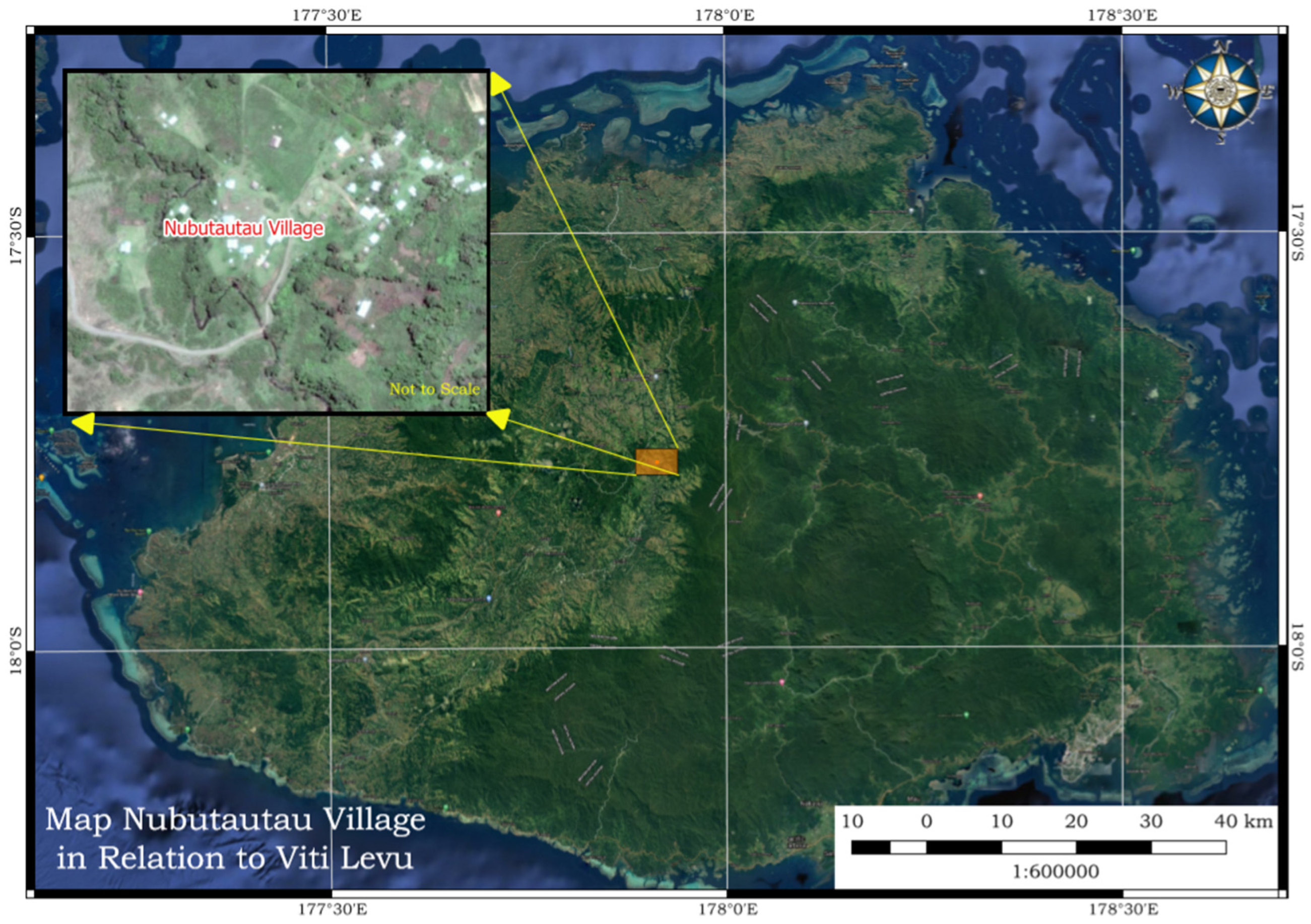
Figure 2.
The outlay of the survey area with the location of key features and their locations.
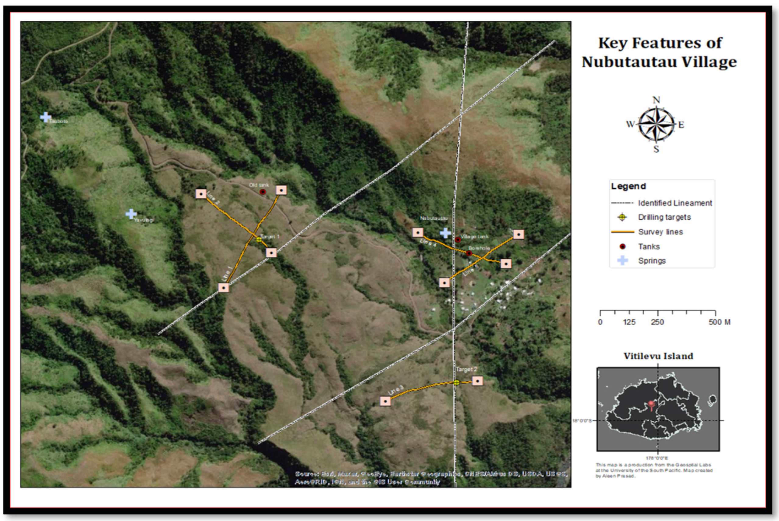
Figure 3.
a)-Conceptual diagram of 4 cable assembly and electrode bindings b)-Conceptualized connection of the 20 electrodes on one cable, through the connection of the jumper wires from the electrodes to the main cable groove.
Figure 3.
a)-Conceptual diagram of 4 cable assembly and electrode bindings b)-Conceptualized connection of the 20 electrodes on one cable, through the connection of the jumper wires from the electrodes to the main cable groove.
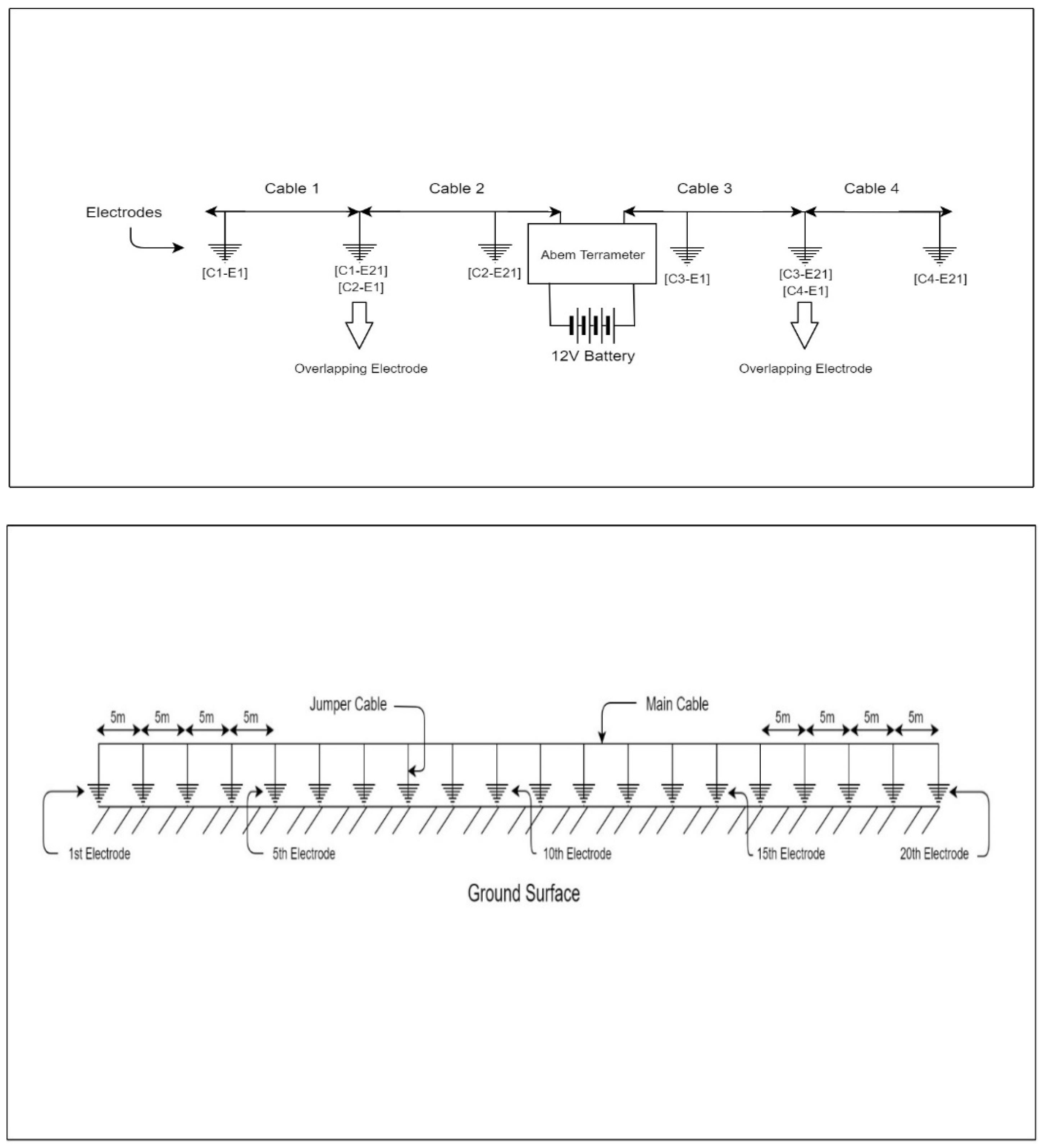
Figure 4.
Field dual connections of the survey cables on the overlapping. Two jumper cables are connected to this electrode one from each cable.
Figure 4.
Field dual connections of the survey cables on the overlapping. Two jumper cables are connected to this electrode one from each cable.
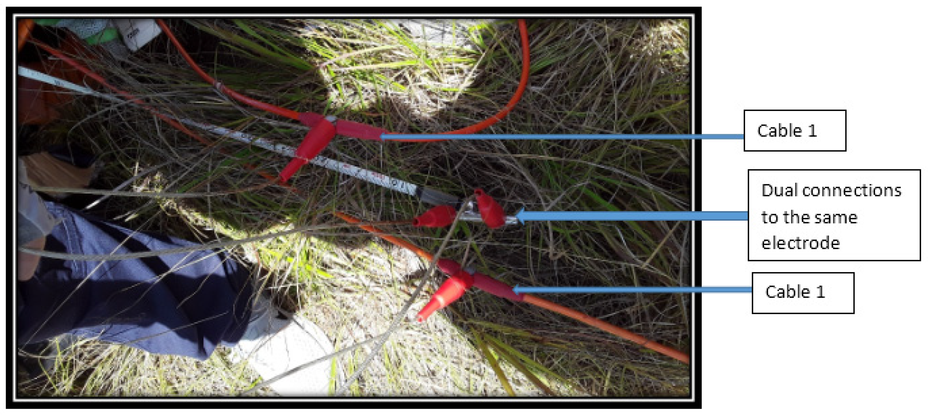
Figure 5.
The Tomogram of the Survey line 1 with the elevation scale and near surface topography features.
Figure 5.
The Tomogram of the Survey line 1 with the elevation scale and near surface topography features.
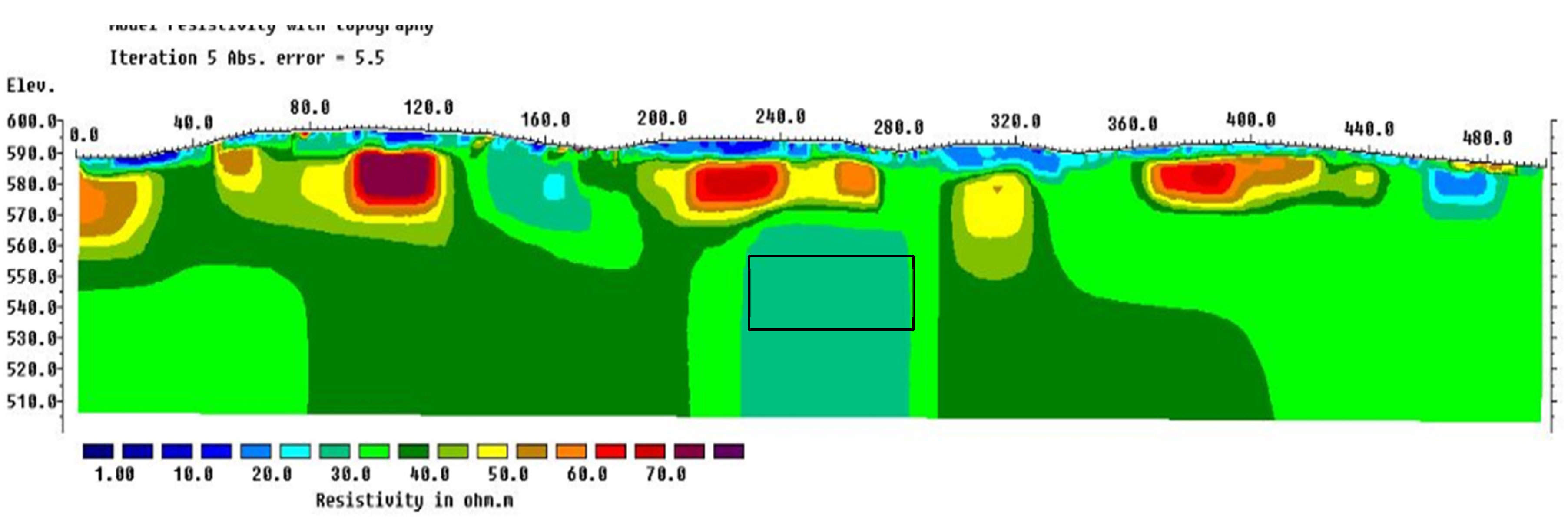
Figure 6.
Tomogram of Survey line 2 with the variation in resistivity below ground level (bgl).

Figure 7.
Tomogram for the Survey line 3 (target 2) with elevation height and the near surface topographical features.
Figure 7.
Tomogram for the Survey line 3 (target 2) with elevation height and the near surface topographical features.
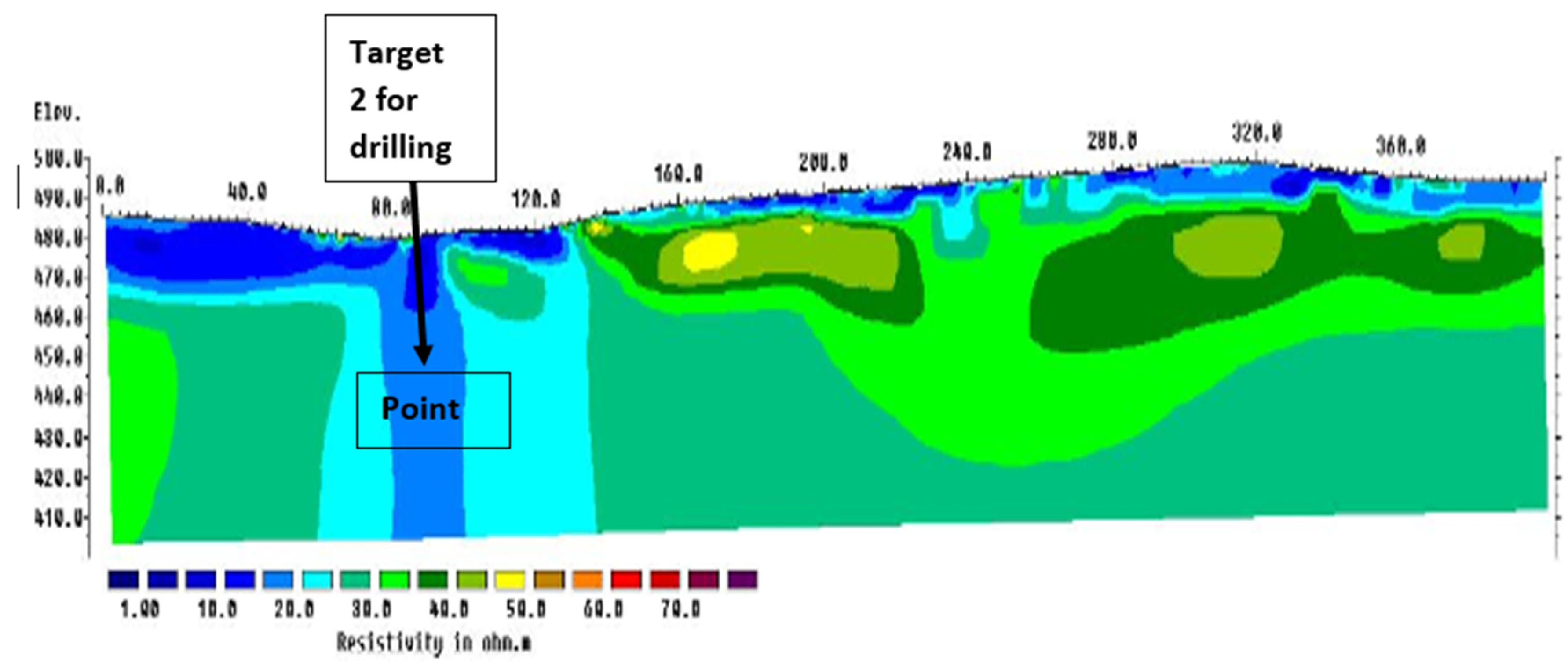
Figure 8.
Tomogram of survey line 4 with the variation in resistivity below ground level.
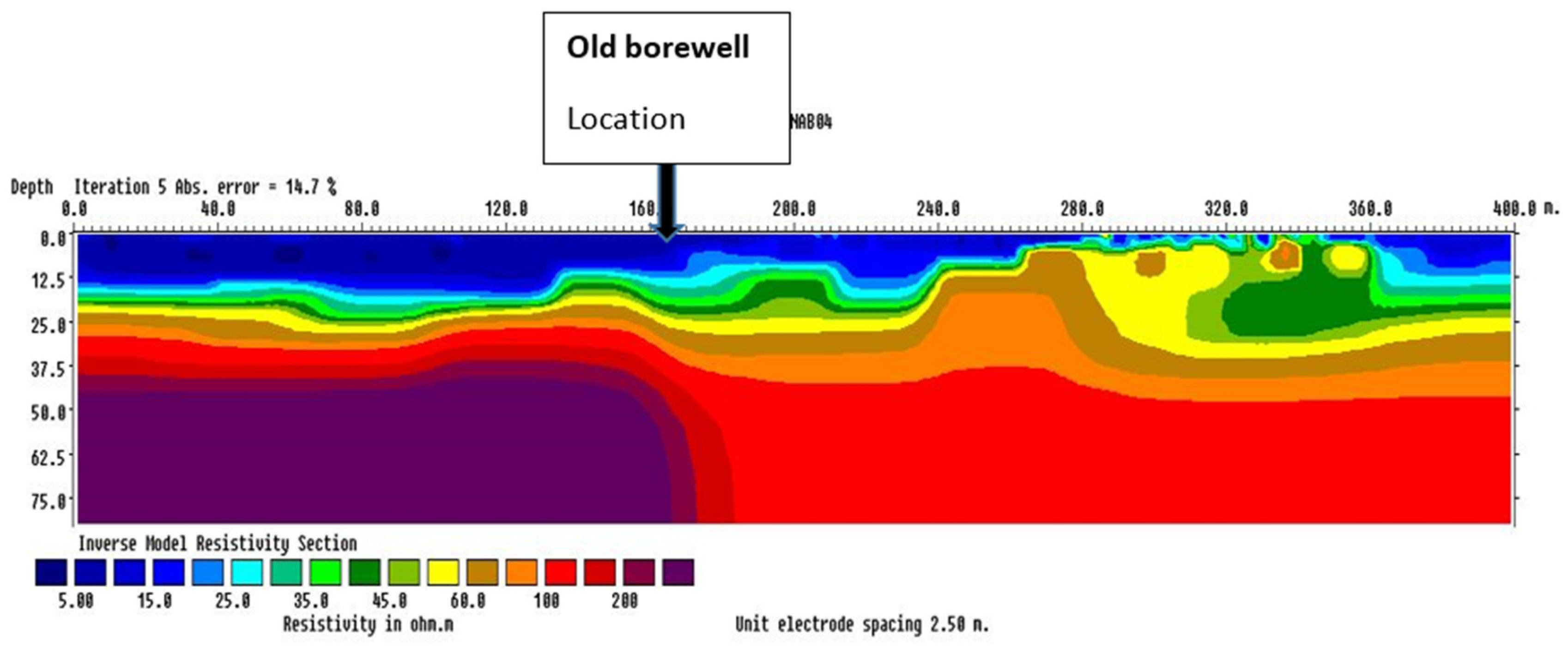
Figure 9.
Tomogram for survey line 5 with the variation in resistivity below ground level.
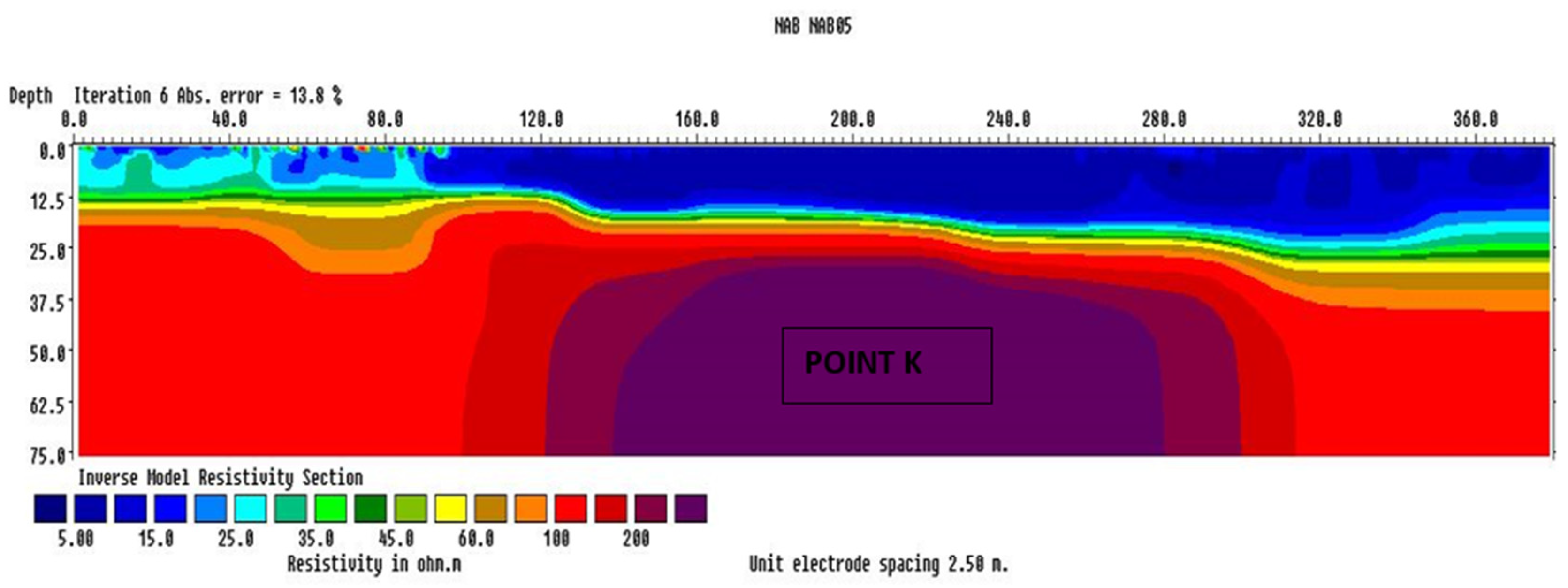

Table 1.
Lithological changes with the variation on the geological profile for the old borehole ear survey line 4 [Loco et al., 2020].
Table 1.
Lithological changes with the variation on the geological profile for the old borehole ear survey line 4 [Loco et al., 2020].
| Formation | Geological characteristics/ Contrast | Depth Range (m) |
|---|---|---|
| Soil and Weathered bed rock | Silty loam- with highly –Completely weathered siltstone | 0-6 |
| Fresh siltstone with minor fractures | Predominately grey, fine grained, well sorted formation with low strength- some weathered material observed between 12-14m indicating inir fracturing and potential ground water sources | 6-24 |
| Weathered Volcanoclastic Formations | Moderate weathered and fractured formation with midrate strength characteristics by noticeably disclosed volcanic clast with brown to reddish brown matric suggesting ground water movement and occurrences | 24-30 |
| Fresh Volcanoclastic Formation with minor fractures | Hard and fresh volcanoclastic zones dominated by the volcanoclastic clast with minor fractures observed between 37 to 45m and denoted some weathered materials | 30-51 |
Table 2.
The resistivity values range in correspondence with the geological materials present below ground level (bgl) [Antoniu et al., 2018].
Table 2.
The resistivity values range in correspondence with the geological materials present below ground level (bgl) [Antoniu et al., 2018].
| Rocks and Sediments type. | Resistivity Range (Ohm.m) |
|---|---|
| Clay Containing brackish to saline water | <3 |
| Clay Containing brackish to fresh water | 5-8 |
| Clay, Silty sand and some gravel saturated with fresh water | 11-25 |
| Weathered basalt containing fresh water | 30-60 |
| Fresh basalt saturated with saline water | 30-40 |
| Fresh basalt saturated with fresh water | 300-700 |
| Dry coral sediments | 500-1000 |
Table 3.
List of the chemical parameters that were tested from the three springs. The tested parameters were analyzed at the Institute of Applied Science laboratory at The University of the South Pacific, Fiji.
Table 3.
List of the chemical parameters that were tested from the three springs. The tested parameters were analyzed at the Institute of Applied Science laboratory at The University of the South Pacific, Fiji.
| Customer ID Lab No |
Spring 1 Nubutautau Spring 2020/3851 |
Spring 2 Tauboto Spring 2020/3852 |
Spring 3 Yavulagi spring 2020/2853 |
Date Analysed |
Method Ref. No |
|---|---|---|---|---|---|
| Alkalinity (mg/L) | 108 | 97.7 | 71.2 | 14/01/20 | AP 2320B |
| Chloride (mg/L) | 90 | 120 | 95 | 20/10/20 | AP 4500-B |
| Calcium (mg/L) | 13.5 | 12.2 | 16.4 | 14/10/20 | AP3111B |
| Electrical Conductivity (mg/L) | 213 | 147 | 185 | 20/10/20 | AP2510B |
| Iron (mg/L) | 3.72 | 1.08 | 1.90 | 15/10/20 | AP3113B |
| Magnesium (mg/L) | 5.41 | 7.61 | 6.75 | 14/10/20 | AP3111B |
| Manganese (mg/L) | <1 | <1 | 1.17 | 15/10/20 | AP 3113B |
| Silica (mg/L) | 28.8 | 43.9 | 46.9 | 04/10/20 | AP 4500-SiD |
| Sodium (mg/L) | 13.9 | 2.30 | 9.85 | 14/10/20 | AP 3500-Na B |
| Sulphate (mg/L) | 2.45 | 4.29 | 10.4 | 12/11/20 | AP 4500-S E |
Disclaimer/Publisher’s Note: The statements, opinions and data contained in all publications are solely those of the individual author(s) and contributor(s) and not of MDPI and/or the editor(s). MDPI and/or the editor(s) disclaim responsibility for any injury to people or property resulting from any ideas, methods, instructions or products referred to in the content. |
© 2023 by the authors. Licensee MDPI, Basel, Switzerland. This article is an open access article distributed under the terms and conditions of the Creative Commons Attribution (CC BY) license (http://creativecommons.org/licenses/by/4.0/).
Copyright: This open access article is published under a Creative Commons CC BY 4.0 license, which permit the free download, distribution, and reuse, provided that the author and preprint are cited in any reuse.


