
Submitted:
14 June 2023
Posted:
15 June 2023
You are already at the latest version
Abstract
Aquifer water is the key staple to develop successful sustainable agricultural activity in newly reclaimed areas in Egypt. Monitoring irrigation water quality is necessary for a proper planning of this exhaustible resources. This work aims to evaluate the groundwater quality in the western newly reclaimed areas of Beni-Suef governorate. Fifty aquifer water sample were collected from wells scattered in the arid western Beni-Suef fringes during May of 2022. Water chemical analyses were conducted to estimate the parameters of Irrigation Water Quality Index (IWQI) namely the Electrical Conductivity (EC), Sodium (Na+), Chloride (Cl-), Bicarbonate (HCO3-) and the Adjusted percentage of Absorbed Sodium (SARo). The Inverse Distance Weighted (IDW) technique used to map the spatial distribution of aquifer water chemical characteristics and IWQI. The results showed that EC values were high in the south of the study area and decreased at its north and east borders. The results showed that the average of dissolved cations and anions were 236.4, 102, 77.5, 106.2, 309.6, 148.1 and 113 meq/l for Ca2+, Mg2+, Na+, K+, SO42-, HCO3-, and Cl-, respectively. Regarding to IWQI, its' values ranged from 28 to 81. Two-thirds of the study area classified as having moderate limitations for sustainable irrigation purposes. Furthermore, one-thirds of the area classified as having high restrictions.
Keywords:
Groundwater
; Irrigation water quality
; GIS
; Arid land
1. Introduction
Groundwater is one of the most important factors of the hydrological cycle in arid and semi-arid regions because of its importance for improving soil quality and crop production to ensure food security (Awad et al., 2022). Most of arid and semi-arid regions depend on groundwater as primary source for agricultural irrigation operations, the continuous depletion of groundwater in those areas has led to lower recharge rates and higher soil (Albadr et al., 2021). The quality of aquifer used for irrigation affects negatively in soil infiltration rates, soil structure, sodicity and salinity, (Chidiac et al., 2023). The negative effects of low irrigation water quality also occur when the coincidence of high salinity, with the toxic effect of some dissolved ions on crop production (Heleika et al., 2021). Many indicators of the quality of irrigation water have been developed to study the aquifer water impact on both soil quality and crop production (Chidiac et al., 2023). These indicators help by converting irrigation water quality data into management maps for decision makers (Simsek and Gunduz, 2007) and stakeholders in handling issues related to the soil environment and irrigation water management (Abbasnia et al., 2019). Geospatial methods, inclusive remotely sensed imagery (RS) and Geographic Information System (GIS) techniques are accurate tools, which have been widely utilized for map ping crops (El-Sharkawy et al., 2016, 2013; El-Sharkawy, 2016; Farg et al., 2020), assessing land use/cover (Arafat et al., 2014; Elsharkawy et al., 2022a; Nabil et al., 2022), soil and water quality (Abdel Rahman et al., 2022; AbdelRahman et al., 2022; Elsharkawy et al., 2022b; Saleh et al., 2021). Satellite imageries provide an ideal characterization of high spatial features in a quick, accurate, reliable, harmonious with low cost significantly over large regions compared with classic techniques (Boori et al., 2021). While, GIS allows collecting, manipulating, storing, and combining dereferenced feature datasets to be inserted in spatial modeling(Uzuner and Dengiz, 2020) and (Xiaodan et al., 2010). The IDW method is classified as one of the estimated elicitation deterministic methods. It considers as an accurate and intuitive method which produces better estimated surfaces when the number of points is limited and their distribution is regular, as it was described by (Azpurua and Dos Ramos, 2010). Irrigation water quality indicators produce a unique value enables judgment on the quality of irrigation water (Chidiac et al., 2023). Most of the different irrigation water quality indicators have a similar methodology that give specific weights to the different chemical irrigation water characteristics based on their importance, but they differ in the nature and number of those characteristics water (Chidiac et al., 2023). Moreover, it is important to point out that the concept of irrigation water quality differs with the different sites targeted by the irrigation process, as the patterns of crops grown, soil conditions, and agrometeorology (AbdelRahman et al., 2022; El-Sharkawy et al., 2013; Saleh et al., 2021). (Simsek and Gunduz, 2007) proposed an irrigation water quality index applied to the Simav plain in Turkey. The proposed indicator relied on the criteria and requirements for the classification of irrigation water quality issued by (Ayers and Westcot, 1999), which take into account chemical water characteristics that reflect the risks of salinity, leaching, permeability problems and the specific toxicity of some ions caused by irrigation water on crops. (Misaghi et al., 2017) classified Irrigation water quality according to the proposed indicator into low, moderate, and high-quality water. They used some of chemical water properties namely sodium, chloride, pH, Sodium Adsorption Ratio (SAR), and Total Dissolved Salts (TDS). The Irrigation Water Quality Index (IWQI) proposed by (Meireles et al., 2010) using the multivariate statistical analysis technique. They classified irrigation water as very poor-quality, poor-quality, moderate-quality, neutral-quality, and high-quality water. The characteristics they used as inputs in the calculations of this indicator were restricted to those included in (Richards, 1954) such as electrical conductivity, sodium, chloride, bicarbonate and SAR. All these characteristics reflect the negative impact of irrigation water salinity, low rates of infiltration, and toxicity problems on crop production. The importance of the IWQI indicator (Meireles et al., 2010) compared to other indicators regarding it was developed mainly for determining the quality of irrigation water, in contrast to the indicator used by (Misaghi et al., 2017) which developed to assess the quality of drinking water produced from treated wastewater. Also, the dependence of the index calculations (Meireles et al., 2010) on the classification of the American salinity laboratory (Richards, 1954) and (Ayers and Westcot, 1999); Which are considered one of the globally most used irrigation water classification systems using minimum datasets available for estimation. The IWQI index was used to assess the quality of irrigation water in Iraq for both wet and dry agricultural seasons by (Abdullah et al., 2016), and for several aquifers in Halayeb and Shalateen area (Rashed et al., 2020) in the southeastern desert of Egypt. Also, it used by (Abdulhady et al., 2018) for several aquifers in the northwest of Minya Governorate, Egypt.
This study aims to map the chemical characteristics of groundwater and assess the quality of aquifer water using IWQI for newly reclaimed arid land in west of Beni-Suef Governorate.
2. Materials & Methods
2.1. Study area
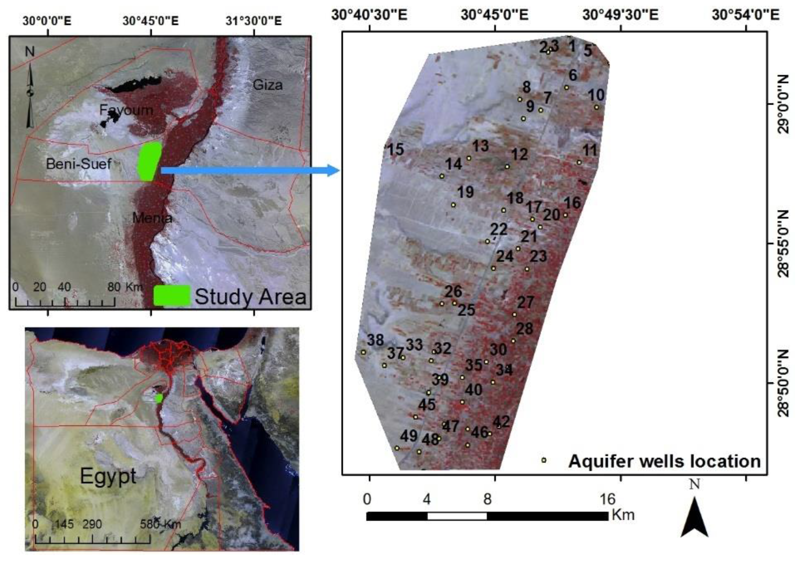
The study area located in middle Egypt within longitude of 30°40'00"E - 30°47'00"E and latitudes of 28°45'00"N - 29°05'00"N and covers an area about 300 km2, Figure (1). The location is dominated by sub orders calcids and gypsids (Embabi, 2004) and slightly slope level ranged from 0.5 % to 2.0 %. In recent decade, the study area witnessed remarkable agricultural development, especially in the south corner, cultivated by strategic crops such as wheat, tomatoes, and onions.
Figure 1.
Location of the study area, overlaid with Sentinel-2 imagery (false colour composition: NIR, Red, Green).
Figure 1.
Location of the study area, overlaid with Sentinel-2 imagery (false colour composition: NIR, Red, Green).
The region climate has a Mediterranean pattern (Beck et al., 2018). The annual rainfall rates are very scarce, with an average of 2 mm/day. The groundwater is the main source of water supplies needed for various uses as agricultural, industrial, and drinking purposes. The drilling of more wells with high water use negatively withdraw the groundwater level. Recently, the high consumption of groundwater quantities led to an imbalance of the aquifer level, and increased the salinity of the water extracted from arid areas (Elsharkawy et al., 2022a). The geological structure in the study site indicate that the unrestricted groundwater-bearing layers follow the Quaternary Aquifer, which is composed of intrusions of sand, gravel, sandstone, and limestone (Said, 1962).
2.2. Field samples and data collection:
Fifty water samples were collected from wells in the study area during the field survey in July 2022. The locations of the sampling wells were determined using a Garmin eTrex GPS device (Garnett and Stewart, 2015; Mahendran et al., 2016). The depth of the still water in the wells ranged from 24 to 120 meters below sea level. Drilling date and depth data were collected for each well. The chemical water properties were analyzed according to the methods indicated by (Greenberg et al., 1992). The analyzed water characteristics include estimation of electrical conductivity, pH, and some major dissolved ions, which included calcium, magnesium, sodium, potassium, bicarbonate, chlorides, and sulfates. Chemical analyzes were carried out at soil and water sciences laboratory, faculty of agriculture, Beni-Suef University. The Total Dissolved Salts (TDS) was also calculated as a function of the degree of electrical conductivity using the relationship proposed by (Albu et al., 1997) as Equation (Eq) 1:
The Rockware (Aq.QA 1.5.0) program was used to determine the water types, % difference of anion-cation and to identify the hydrochemistry of groundwater through the graphic representation of the chemical analyzes of groundwater proposed by (Piper, 1944).
2.3. General description of the IWQI model
The IWQI model (Meireles et al., 2010) was designed to determine the quality of irrigation water by multivariate analysis technique. In order to calculate the relative weights of the various factors in this method, the values of those characteristics derived from the irrigation water quality data as suggested by (Ayers and Westcot, 1999). These factors include EC (dS/m), dissolved sodium, chlorides and dissolved bicarbonates, expressed in meq/l. In addition the SAR proposed by (Suarez, 1981), which was calculated according to (Lesch and Suarez, 2009) as shown in Eq (2).
Where Na+ (meq/l) represents the concentration of dissolved sodium in irrigation water, Ca+2 (meq/l) is the concentration of modified calcium dissolved in irrigation water, and Mg+2 (meq/l) is the concentration of magnesium dissolved in irrigation water. The contribution of each parameter is determined separately when calculating the irrigation water quality index, so that this contribution includes both the estimated irrigation water quality values (qi) and the relative weight (wi). Equation (3) is also used to calculate the (qi) values, as follows: the next:
Where qi represents the estimated water quality values for each single parameter (Table 1); qmax represents the maximum value for each class. Xi is the measured value of each parameter, Xinf is the minimum value of the measured factor, qiamp is the capacity of the class, and Xamp is the corresponding capacity value of the class that the parameter estimate.
The wi values reflect the standard weight of the properties which related to its importance in explaining the total change in water quality, which is shown in Table 2.
The IWQI values (Meireles et al., 2010) f for irrigation purposes are determined from Equation (4) as follows:
According to the above equation, the IWQI is a unitless index, and its value ranges from 0 to 100. The different divisions of irrigation water shown in Table (3). It was classified based on the limitations of irrigation water use (Holanda and Amorim, 1997) such as salinity problems, the decrease in soil water infiltration rates, and the toxic effects on the plant.

Table 3.
Weight importance (Wi) for different characteristics.
| IQWI value | Limitations | Recommendations |
|---|---|---|
| 100 to 85 | -- | Suitable for all soil types and crops |
| 85 to 70 | Low | Not recommended in heavy soils and salinity sensitive crops |
| 70 to 50 | Normal | Recommended in moderate soils with continues leaching |
| 50 to 40 | High | Recommended in sandy soils with no compacted layers and crops that are not sensitive to salinity |
| < 40 | Very high | Not recommended in for regular irrigation conditions |
2.4. Spatial distribution maps of chemical properties:
The spatial distribution maps of groundwater characteristics were obtained using the Inverse Distance Weighted (IDW) technique in the geographic information systems (GIS) environment by ArcGIS 10.8 software, developed by the Environmental Systems Research Institute (ESRI) (ArcGIS, 2012). The IDW method is a quick deterministic interpolator that produce better estimated surfaces when the number of points is limited and their distribution is regular, as it was described by (Azpurua and Dos Ramos, 2010).
where: z(x0) is the predicted value of the property under study at location x0, n is the total number of available data (50 points in this study), and xi is the value of the property at location I; h represents the distance between the point at the predicted element and β denotes the exponent of the distance. In this study a value of the exponent = 2 was chosen as recommended by (Babak and Deutsch, 2009). They indicated that this value is the most widely used when applying the IDW method in spatial estimations.
3. Results & Discussion
3.1. The chemical properties of groundwater
Figure (2) shows the numbers of wells, their locations, and the spatial distribution of the analysis of the chemical properties of groundwater. It shows that the pattern of spatial distribution of dissolved ions is very similar to the pattern of spatial distribution of the degree of electrical conductivity, where the group of wells from 25 to 31 constitutes a focus in which the concentrations of dissolved ions rise. Figure (2 b) shows that there is a relative increase in pH values at the northern border of the study area compared to the rest of the regions. Moreover, the spatial distribution demonstrated in Figure (2, f &h) also showed that the northern region has low concentrations of dissolved chloride and bicarbonate. Figure (2, a) shows that the salinity is concentrated in the south of the study area, and its effect extends towards the northwest. It is also clear that the pattern of spatial distribution of each of the Potassium and sulfates is very similar (Figure 2 g &i).
Figure 2.
The spatial distribution of some chemical properties of the well water of the study area.
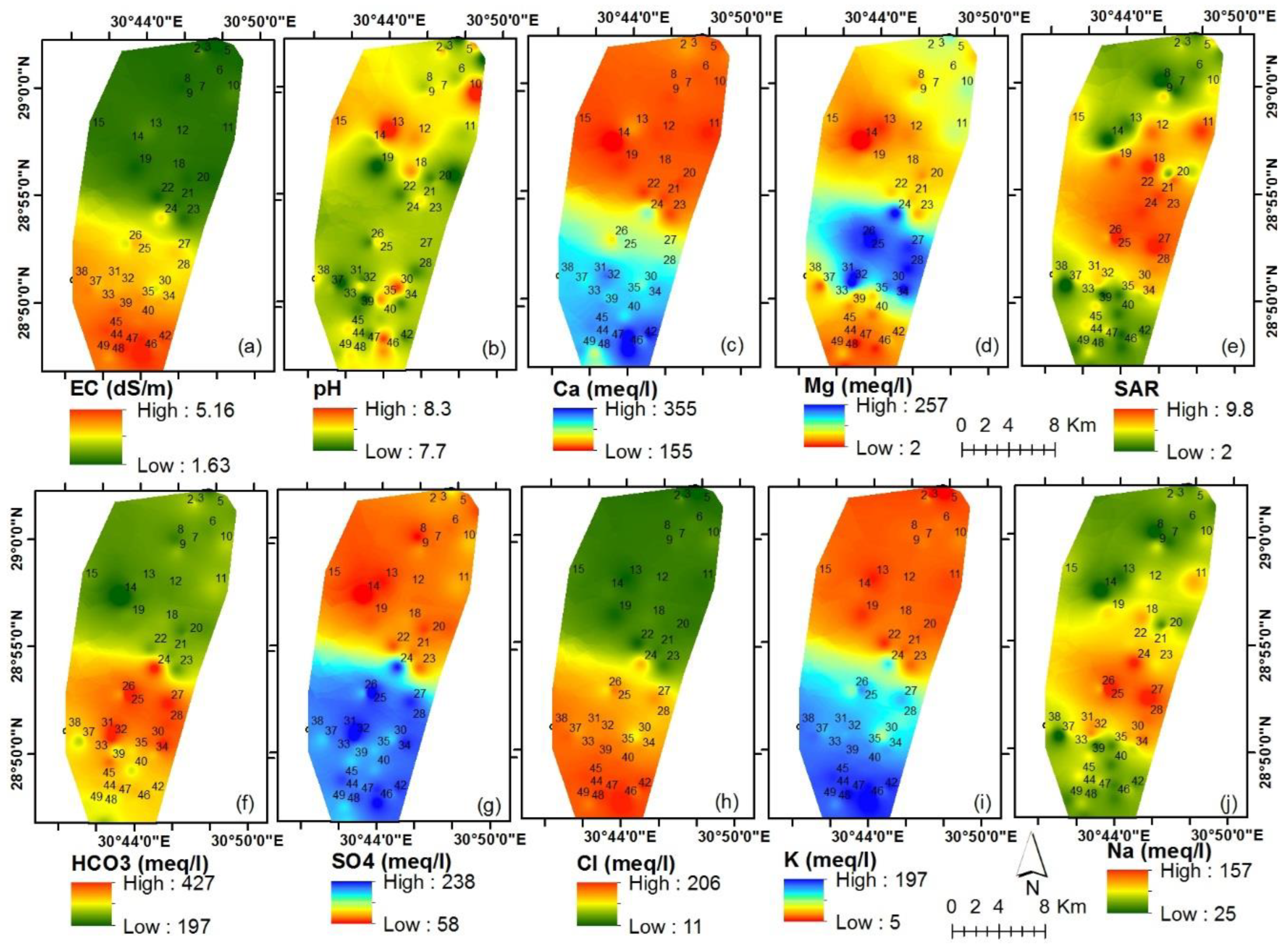
Table (4) shows some statistical characteristics of the chemical properties of groundwater in the study area. The results showed that the values of the pH ranged between 7.7 and 8.3, with a relatively low coefficient of variation (0.04%), and it falls within the suitable range for irrigation water (6.5 to 8.4) recommended by (Ayers and Westcot, 1999). Also, the results showed that the average depth of the still water level below ground level (WSL) in the study area was 83 meters, and that the lowest depth was recorded at 45 meters in well (10) located in the north middle of the study area. while recording the maximum depth 117 meters at well (49) located in the southwest of the study area. These results agree with what was concluded by (Ramesh and Srinithi, 2014) that the pH values decrease with the increase in the concentration of bicarbonate in the groundwater.
Table 4.
Descriptive Statistics of some groundwater chemical properties.
| Parameters | Ca++ | Mg++ | Na+ | K+ | HCO3- | SO4-- | Cl- | SARo | pH | EC | TDS | WSL |
|---|---|---|---|---|---|---|---|---|---|---|---|---|
| meq/l | dS/m | ppm | m | |||||||||
| AVG | 236.4 | 102.0 | 77.5 | 106.2 | 309.6 | 148.1 | 113.0 | 5.9 | 7.9 | 3.24 | 1328.5 | 82.9 |
| Min | 155.4 | 2.2 | 25.8 | 5.6 | 197.8 | 58.0 | 11.7 | 2.0 | 7.7 | 1.63 | 668.7 | 45 |
| Max | 355.5 | 256.9 | 156.7 | 197.4 | 426.9 | 238.2 | 206.4 | 9.8 | 8.3 | 5.16 | 2112.6 | 117 |
| S.E. | 8.5 | 9.8 | 4.6 | 8.1 | 8.1 | 8.7 | 8.1 | 0.3 | 0.0 | 0.15 | 63.0 | 13.1 |
| SD | 60.0 | 69.2 | 32.3 | 57.2 | 57.1 | 61.8 | 57.4 | 2.2 | 0.2 | 1.09 | 445.4 | 1.8 |
| CV | 17.6 | 19.7 | 9.2 | 16.3 | 16.2 | 17.1 | 16.3 | 0.6 | 0.04 | 0.31 | 126.6 | 3.7 |
Where: Avg is the Mean value; Min is the Minimum value; Max is the Maximum value; SE is the Standard Error value; SD is the Standard Deviation value; CV is coefficient of variation; WSL is the still water level below ground level, EC is the Electrical Conductivity, Na+ is the concentration of dissolved Sodium, Cl- is the concentration of dissolved Chloride, HCO3- is the concentration of dissolved Bicarbonate and SAR is the Sodium Absorbed Ratio.
The coefficient of difference values in the concentration of the dissolved main ions show the clear differences between the groundwater wells in their content of those ions, as shown in Table (4). The results showed a significant variation in the degree of electrical conductivity (EC) in the collected samples. It ranged between 1.63 to 5.16 dS/m, with a standard deviation about 1.09 dS/m and coefficient of variation 0.31%. The high values of EC degree in the wells were those located in the south of the study area, wells (38 to 49), as shown in Figure (2, a). The concentrations of Magnesium and Calcium were the most different by 19.7% and 17.6%, respectively. While the Sodium ions were the least different (9.2%). Moreover, Bicarbonate ions and Sulfate represent the largest percentage of the total dissolved salts components, at 27% and 16%, respectively. The contribution of the rest of the ions in the components of the total dissolved salts was 14, 11, 2, 7, and 10% for Calcium, Magnesium, Potassium, Sodium, and Chloride, respectively.
Table (4) shows that the SARo values ranged from 2 to 9.8, with an average value of 5.9, and a coefficient of difference of 0.6%. According to (Bouaroudj et al., 2019), most of the groundwater of north Africa have less than 3 values of the modified sodium absorption rate, and therefore it does not document when using the emergence of problems related to the sodium absorption rate. While the values of the modified sodium absorption rate ranged in the water is between 1 and 7. The wells at middle area (11, 12 and 18 to 27) have water characterized with average SARo 7, which expected to cause permeability problems in the soil when it used for irrigation.
Regarding to permeability, Figure (2, e) shows the spatial distribution of the modified SARo values, where the SARo values are higher in the middle of the study area compared to the north and south borders. This distribution pattern is attributed to the high values of sodium in the water of the wells of that region, which may also indicate the existence of a direct hydraulic connection between the wells of that region. The expected harmful effect when using high SARo water is represented in the adsorption of sodium on the colloidal surfaces of the soil and its replacement with magnesium, and the rest of the cations, causing a decrease in the rate of soil permeability (Elsayed et al., 2020) and hardening of the soil at the surface, and damage to the germination processes (Bazza et al., 2018).
3.2. Correlation between different chemical properties of groundwater:
Pearson correlation coefficient has been estimated to measure the degree of correlation between different chemical properties. Although the hydrochemical processes of groundwater are very complex, such an analysis may allow understanding some aspects of these processes (Li et al., 2018).
Table 5 shows the correlation matrix for the linear relationships between the different chemical properties of groundwater. The results showed that there is a negative and significant correlation at the level of 0.05 between pH and other chemical properties.
The values of the correlation coefficient for the degree of interaction (pH) were more negative with magnesium (-0.097) and with sulfate (-0.061). The correlation was also positive and high at a significant level of 0.05 between the degree of electrical conductivity and the water content of potassium (0.992), chloride (0.990), calcium (0.953), and to a lesser extent with magnesium (-0.013) and sodium (0.025). High values of the correlation coefficient between the degree of electrical conductivity and the water content of dissolved ions indicate that these ions control the values of the degree of electrical conductivity (Sundaray, 2010). The results also showed a positive and high correlation between bicarbonate with magnesium and calcium by (0.711) and (0.706), respectively. The high positive correlations between the calcium and magnesium ions indicate the occurrence of dissolution and sedimentation processes for the minerals dolomite and calcite (Aris et al., 2007), especially since the correlation between them with the bicarbonate ion is relatively high when compared with association with sodium and potassium ions. The occurrence of such pollution also confirms that each of the bicarbonate and sulfate ions were more significantly related to cations compared to the chloride ions, which was low and insignificant at the level of 0.05.
3.3. The relative quality dominance of dissolved ions in well water:
The average relative abundance of dissolved ions in the well water of the study area was 65.8, 20.4, 13.8 for chlorides, sulfates, and bicarbonate. As shown in Figure (3), the specific dominance of the anions was bicarbonate, according to their relative distribution on the triangle of the anions, where their ratios ranged from 40 to 58, for wells (25 - 34).
Figure 3.
Piper diagram to determine the specific dominance of cations and anions.
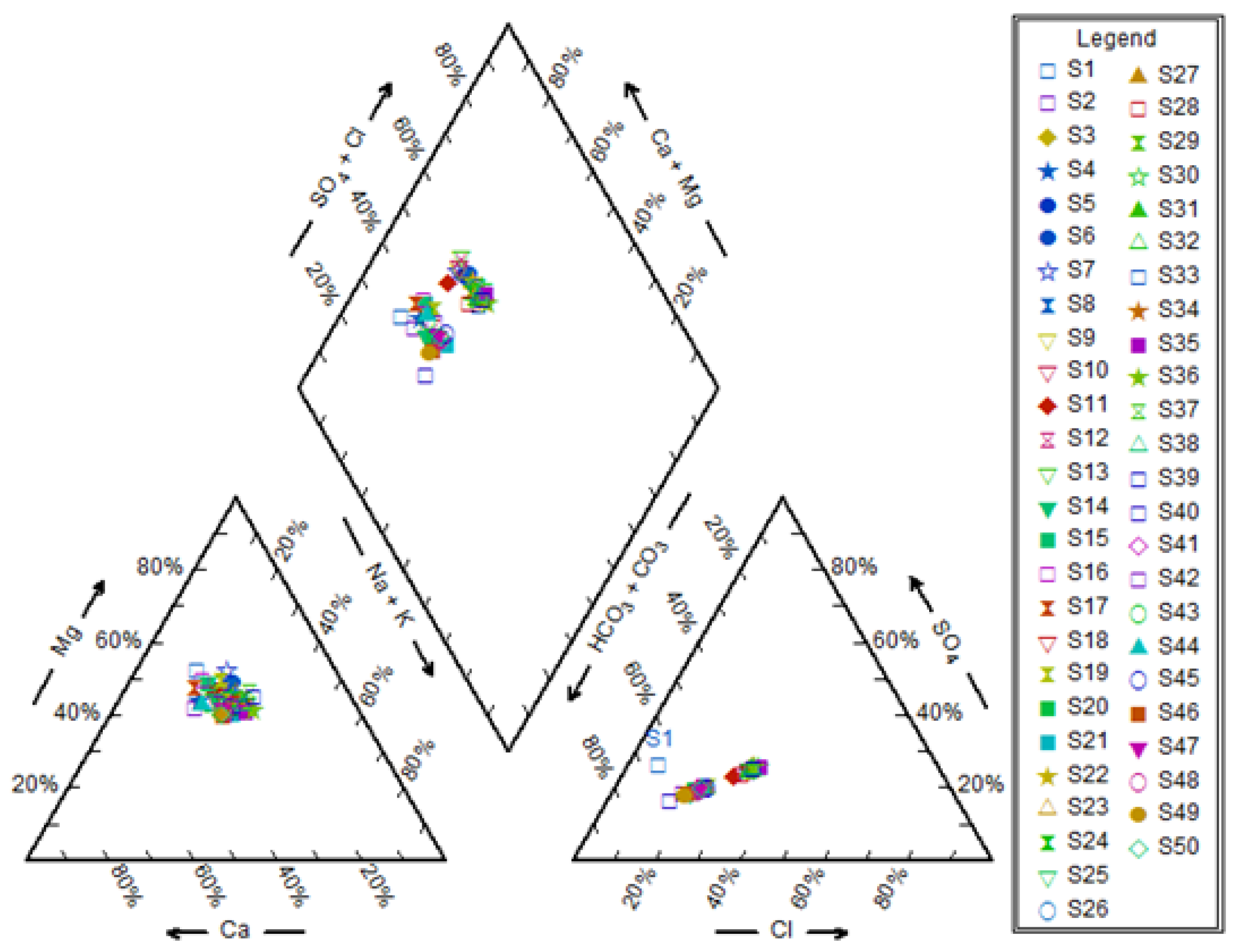
The specific predominance of sulphate was high in wells (28, 34, 46), with a predominance of 33, 32, and 33, respectively. Although the specific predominance of chloride ion for well 46 was the highest, the water of the rest of the wells was characterized by relatively low levels of chloride with average 113 meq/l. As for the dissolved cations, the mean relative abundances, expressed in meq/l, were 35.3, 22.4, 11.2, 0.9 for sodium, magnesium, calcium, and potassium, respectively. The relative distribution of these ions on the triangle of cations shows that the predominance of sodium and potassium ions exceeded in wells (10, 11, 34, 35, 39, 46). Regarding potassium ions, generally it has low percentage, as shown in Table (4).
3.4. Irrigation water quality index
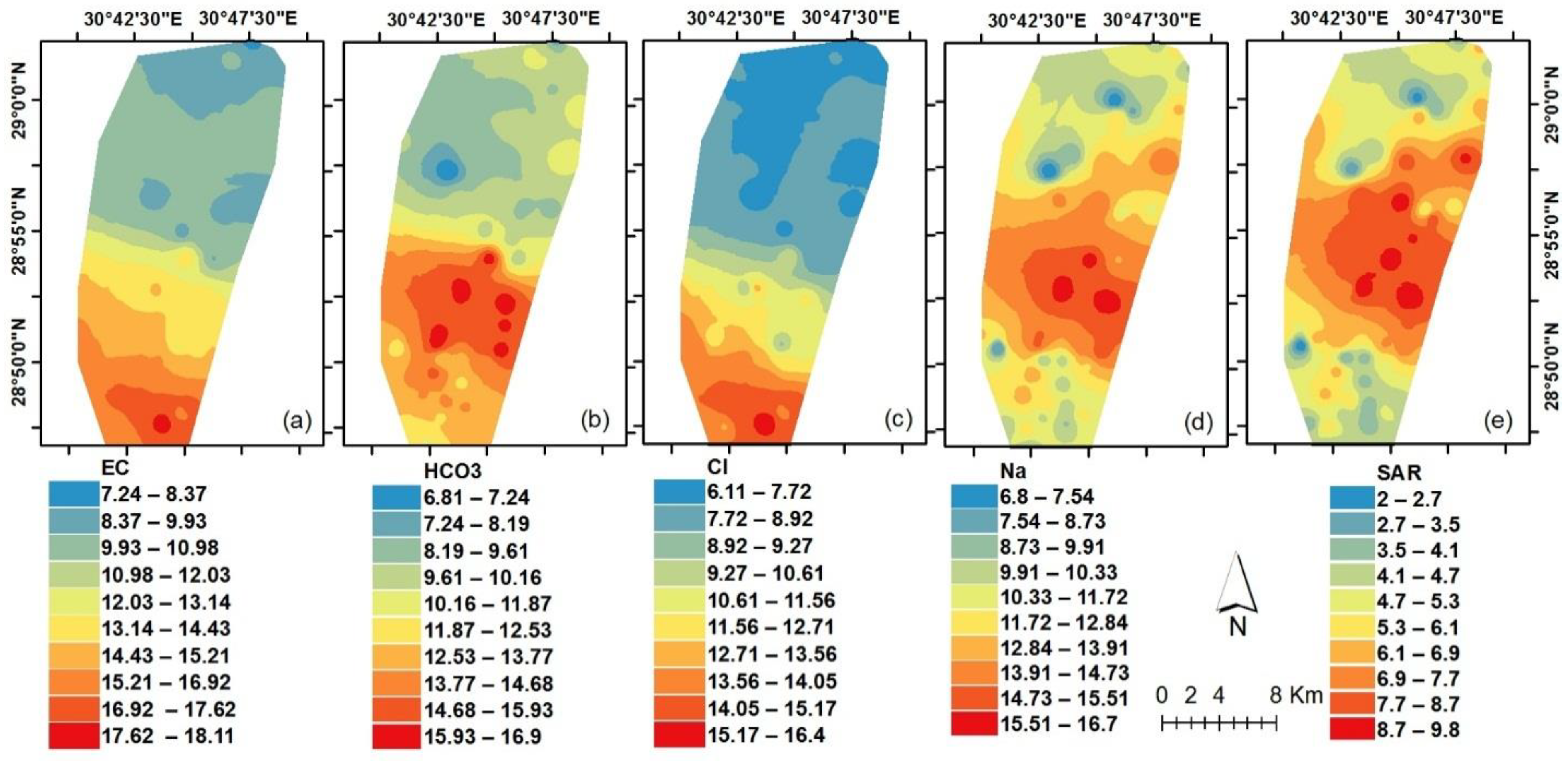
The values of electrical conductivity, sodium, chloride, bicarbonate, and sodium adsorption ratio were used to estimate the irrigation water quality index, as suggested by (Meireles et al., 2010). Figure (4) show the spatial distribution of the contribution of electrical conductivity, sodium, chloride, bicarbonate, and sodium adsorption percentage to the irrigation water quality index values, respectively. As indicated by (Meireles et al., 2010), the higher the contribution values, the better the irrigation water quality. It can be seen from Figure (4) the great similarity in the spatial distribution pattern of the contribution of electrical conductivity, bicarbonate and chloride. This similarity can be attributed to the fact that the degree of electrical conductivity is related to the total dissolved salts, of which bicarbonate and chloride constitute most of its components, especially in arid areas far from freshwater sources (Li et al., 2018). The values of relative importance for each of the degree of electrical conductivity, bicarbonate, and sodium are close, as shown in Table (2), which may also explain some similarities in the spatial distribution pattern of these ions. Figure (4, b) shows a slightly increase in the values of the contribution of bicarbonate in the southeast of the study area, and its increase in the direction of the middle, and then its decrease again in the north borders. The dissolution processes that take place in aquifers containing limestone have an impact on the rise in the dissolved calcium and magnesium values, especially in the south of the study area, where in turn the values of the modified adsorbent sodium contribution decrease (Appelo, 1994) compared to the rest of the study area, as shown in Figure (4, e).
Figure 4.
The spatial distribution of EC, HCO3-, Na+, Cl- and SAR contribution to IWQI values.
The irrigation water quality index was calculated using equation (3), taking into account the various factors, and their relative weight. Depending on usage restrictions shown in Table (3), the water of 14 wells with high use restrictions namely (wells no 25, 27, 28, 29, 32 to 38, 40, 48 and 50) as shown in Figure (5). These wells have water quality index values ranging from 38 to 51, which can be used for irrigating highly salt tolerant crops cultivated in highly permeable soils, that do not contain compacted layers and the irrigation process must be carried out with a high frequency. Furthermore, the water of seven wells was classified as having moderate usage restrictions namely (wells no 2, 10, 12, 13, 18, 26 and 30). Their IWQI values ranged between 50 and 70. This type of water is suitable for irrigating crops that are medium tolerant to salinity and grown in highly permeable soils, with medium leaching of salts to prevent soil degradation.
Figure 5.
The spatial distribution of the irrigation water quality index values.
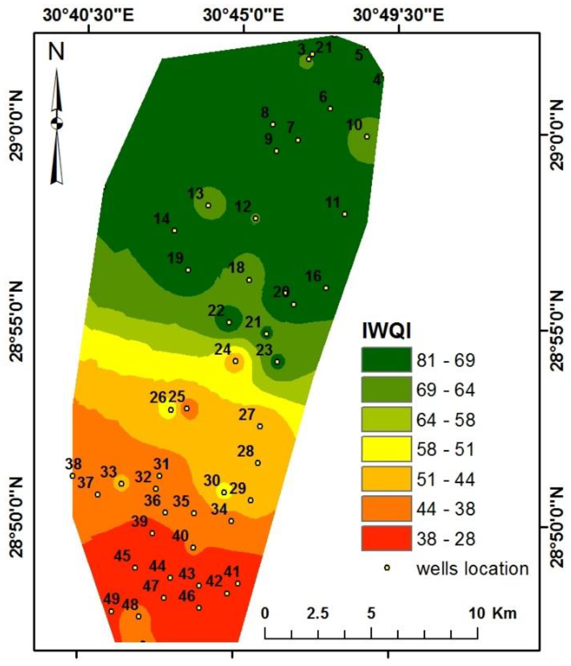
The results also showed that there were three wells (1, 3 and 5) had low use restriction characteristics for irrigation purposes, as the value of the water quality index ranged between 70 and 85. This type of water is suitable for irrigating salinity-sensitive crops. As shown in Figure (5), the irrigation water quality index decreases at the south of the study area and increase forward the north borders. Moreover, the results obtained from the spatial distribution of the irrigation water quality index show that 62.5% of the study area is classified as having water with moderate use restrictions for irrigation purposes, and 27% of it is classified as having a high degree of restriction of irrigation use, 10% of the area has very high limitations, while 0.5% of the area has low-restriction water for irrigation purposes.
4. Conclusions
Regarding to water salinity, the degree of electrical conductivity was high in the south area and decreasing from south to north. The pattern of the spatial distribution of each of the chloride and bicarbonate ions is very similar to the pattern of the EC, which gives a great indication that the main component of the dissolved salts in most of the well water in the study area contain the dolomite and calcite minerals. The relative abundance of the major dissolved cations was calcium, followed by magnesium, then sodium, and finally potassium. As for the main dissolved anions, the dominance was for bicarbonates, sulfates, and then chlorides. The results of using the irrigation water quality index indicated that it is possible to classify most of the well water in the study area as having moderate and medium restrictions. The obtained results can contribute to the success of the irrigation programs in the western fringes of Beni-Suef and achieve sustainability in the limited water resources available.
References
- Abbasnia, A., Yousefi, N., Mahvi, A.H., Nabizadeh, R., Radfard, M., Yousefi, M., Alimohammadi, M., 2019. Evaluation of groundwater quality using water quality index and its suitability for assessing water for drinking and irrigation purposes: Case study of Sistan and Baluchistan province (Iran). Hum. Ecol. Risk Assess. An Int. J. 25, 988–1005. [CrossRef]
- Abdel Rahman, M.A.E., Saleh, A.M., Elsharkawy, M.M., Farg, E., Moustafa;, M., Abutaleb, K., Arafat, S.M., 2022. Geomatics-Based Mapping of Hydraulic Soil Properties for Agricultural Management. Ann. Agric. Sci. Moshtohor. 60, 225–238. [CrossRef]
- AbdelRahman, M.A.E., Farg, E., Saleh, A.M., Sayed, M., Abutaleb, K., Arafat, S.M., Elsharkawy, M.M., 2022. Mapping of soils and land-related environmental attributes in modern agriculture systems using geomatics. Sustain. Water Resour. Manag. 8, 116.
- Abdulhady, Y., Zaghlool, E., Gedamy, Y., 2018. Assesment of the Groundwater Quality of the Quaternery Aquifer in Reclaimedareas at the Northwestern El-Minya Governorate–Egypt, using the Water Quality Index. Int. J. Recent Sci. Res. 9, 23033–23047.
- Abdullah, T.O., Ali, S.S., Al-Ansari, N.A., 2016. Groundwater assessment of Halabja Saidsadiq Basin, Kurdistan region, NE of Iraq using vulnerability mapping. Arab. J. Geosci. 9, 1–16.
- Albadr, M., El-Kammar, A.M., El-Kammar, M.M., Yehia, M.M., Abu Salem, H.S., 2021. Hydrogeological Characteristics of the Quaternary aquifer in Beni Suef area, Egypt. Egypt. J. Geol. 65, 73–89.
- Albu, M., Banks, D., Nash, H., Albu, M., Banks, D., Nash, H., 1997. History of mineral and thermal waters. Miner. Therm. Groundw. Resour. 3–20.
- Appelo, C.A.J., 1994. Cation and proton exchange, pH variations, and carbonate reactions in a freshening aquifer. Water Resour. Res. 30, 2793–2805.
- Arafat, S.M., Afify, A.A., Nagwan, M.A., Elsharkawy, M.M., 2014. Change detection of land use/land cover categories in the Nile Delta region using remote sensing and GIS, in: SPIE Remote Sensing. in Proceedings of the SPIE Remote Sensing and SPIE Security, Amsterdam, Netherland, p. vol. 9239.
- ArcGIS, 2012. Environmental Systems Research Institute (ESRI): Redlands. CA, USA.
- Aris, A.Z., Abdullah, M.H., Ahmed, A., Woong, K.K., 2007. Controlling factors of groundwater hydrochemistry in a small island’s aquifer. Int. J. Environ. Sci. Technol. 4, 441–450.
- Awad, M., Mohamed, E.A., Saber, S.G., ElSayed, E.E., Yehia, M.M., Nassar, T., Mahran, M.R., 2022. Hydrogeochemical studies of the groundwater at the flood plain Quaternary aquifer in Beni suef area, Egypt. Egypt. J. Chem.
- Ayers, R.S., Westcot, D.W., 1999. The water quality in agriculture, 2nd. Camp. Gd. UFPB.(Studies FAO Irrig. drainage, 29).
- Azpurua, M.A., Dos Ramos, K., 2010. A comparison of spatial interpolation methods for estimation of average electromagnetic field magnitude. Prog. Electromagn. Res. M 14, 135–145.
- Babak, O., Deutsch, C. V, 2009. Statistical approach to inverse distance interpolation. Stoch. Environ. Res. Risk Assess. 23, 543–553. [CrossRef]
- Bazza, M., Kay, M., Knutson, C., 2018. Drought characteristics and management in North Africa and the Near East. FAO Water Reports.
- Beck, H.E., Zimmermann, N.E., McVicar, T.R., Vergopolan, N., Berg, A., Wood, E.F., 2018. Present and future Köppen-Geiger climate classification maps at 1-km resolution. Sci. Data 5, 180214. [CrossRef]
- Boori, M.S., Choudhary, K., Paringer, R., Kupriyanov, A., 2021. Spatiotemporal ecological vulnerability analysis with statistical correlation based on satellite remote sensing in Samara, Russia. J. Environ. Manage. 285, 112138. [CrossRef]
- Bouaroudj, S., Menad, A., Bounamous, A., Ali-Khodja, H., Gherib, A., Weigel, D.E., Chenchouni, H., 2019. Assessment of water quality at the largest dam in Algeria (Beni Haroun Dam) and effects of irrigation on soil characteristics of agricultural lands. Chemosphere 219, 76–88.
- Chidiac, S., El Najjar, P., Ouaini, N., El Rayess, Y., El Azzi, D., 2023. A comprehensive review of water quality indices (WQIs): history, models, attempts and perspectives. Rev. Environ. Sci. Bio/Technology 22, 349–395.
- El-Sharkawy, M., Sheta, A., Abd El-Wahed, M.S., Arafat, S.M., El Behiery, O.M., 2016. Precision agriculture using remote sensing and GIS for peanut crop production in arid land. Int. J. Plant Soil Sci. 10, 1–9.
- El-Sharkawy, M.M., 2016. Precision agriculture using advanced remote sensing techniques for peanut crop in Arid Land. J. Hyperspectral Remote Sens. 6, 72–81.
- El-Sharkawy, M.M., Abd El-Hady, A.M., Arafat, S.M., Aggag, A.M., 2013. Precision farming using remote sensing and GIS to improve soil and potato crop management. J. Agric. Environ. Sci. 21, 8–16.
- Elsayed, S., Hussein, H., Moghanm, F.S., Khedher, K.M., Eid, E.M., Gad, M., 2020. Application of irrigation water quality indices and multivariate statistical techniques for surface water quality assessments in the Northern Nile Delta, Egypt. Water 12, 3300.
- Elsharkawy, M.M., Nabil, M., Farg, E., Arafat, S.M., 2022a. Impacts of land-use changes and landholding fragmentation on crop water demand and drought in Wadi El-Farigh, New Delta project, Egypt. Egypt. J. Remote Sens. Sp. Sci. 25, 873–885.
- Elsharkawy, M.M., Sheta, A.E.A.S., D’Antonio, P., Abdelwahed, M.S., Scopa, A., 2022b. Tool for the Establishment of Agro-Management Zones Using GIS Techniques for Precision Farming in Egypt. Sustainability 14. [CrossRef]
- Embabi, N.S., 2004. The geomorphology of Egypt, vol. I: the Nile Valley and the Western Desert. the Egyptian Geographical Society, Cairo, Cairo, Egypt.
- Farg, E., Abutaleb, K., Arafat, S., Elsharkawy, M.M., Nabil, M., 2020. Assessment of Sentinel-2 data capabilities for vegetation physiological parameters retrieving in the Nile Delta. Biosci. Res. 17, 467–478.
- Garnett, R., Stewart, R., 2015. Comparison of GPS units and mobile Apple GPS capabilities in an urban landscape. Cartogr. Geogr. Inf. Sci. 42, 1–8.
- Greenberg, A.E., Clesceri, L.S., Eaton, A.D., 1992. Standard Methods for the Examination of Water and Wastewater (18" Edition), APHA-Aww. AWEF, Washingt. DC, USA 247–262.
- Heleika, M.A., Toney, S., Ismail, E., 2021. Mapping of groundwater opportunities for multi-purposes use in Beni-Suef province, Egypt. Arab. J. Geosci. 14, 784.
- Holanda, J.S., Amorim, J.A., 1997. Management and control salinity and irrigated agriculture water, in: Congresso Brasileiro de Engenharia Setting. pp. 137–169.
- Lesch, S.M., Suarez, D.L., 2009. A short note on calculating the adjusted SAR index. Trans. ASABE 52, 493–496.
- Li, X., Wu, H., Qian, H., Gao, Y., 2018. Groundwater chemistry regulated by hydrochemical processes and geological structures: a case study in Tongchuan, China. Water 10, 338.
- Mahendran, N., Kuys, S.S., Downie, E., Ng, P., Brauer, S.G., 2016. Are Accelerometers and GPS Devices Valid, Reliable and Feasible Tools for Measurement of Community Ambulation After Stroke? 1. Brain Impair. 17, 151–161.
- Meireles, A.C.M., Andrade, E.M. de, Chaves, L.C.G., Frischkorn, H., Crisostomo, L.A., 2010. A new proposal of the classification of irrigation water. Rev. Ciência Agronômica 41, 349–357.
- Misaghi, F., Delgosha, F., Razzaghmanesh, M., Myers, B., 2017. Introducing a water quality index for assessing water for irrigation purposes: A case study of the Ghezel Ozan River. Sci. Total Environ. 589, 107–116.
- Nabil, M, Farg, E., Arafat, S.M., Aboelghar, M., Afify, N.M., Elsharkawy, M.M., 2022. Tree-fruits crop type mapping from Sentinel-1 and Sentinel-2 data integration in Egypt’s New Delta project. Remote Sens. Appl. Soc. Environ. 27, 100776. [CrossRef]
- Piper, A.M., 1944. A graphic procedure in the geochemical interpretation of water-analyses. Eos, Trans. Am. Geophys. Union 25, 914–928.
- Ramesh, K., Srinithi, K., 2014. Hydrochemical Characteristics of Groundwater in Mayiladuthurai Block of Nagapattinam District, Tamil Nadu. Int. J. ChemTech Res. 6, 5698–5708.
- Rashed, H.S.A., H Ahmed, F.O., Abdel Salam, A.A., Faid, A.M., 2020. Assessment of Groundwater Quality for Different Aquifers in Halaib and Shalatien Area at South Eastern Desert of Egypt. J. Soil Sci. Agric. Eng. 11, 203–214.
- Richards, L.A., 1954. Diagnosis and improvement of saline and alkali soils. LWW.
- Said, R., 1962. The Geology of Egypt. Elsevier Publishing Company, Amsterdam.
- Saleh, A.M., Elsharkawy, M.M., AbdelRahman, M.A.E., Arafat, S.M., 2021. Evaluation of Soil Quality in Arid Western Fringes of the Nile Delta for Sustainable Agriculture. Appl. Environ. Soil Sci. 2021, 1434692. [CrossRef]
- Simsek, C., Gunduz, O., 2007. IWQ index: a GIS-integrated technique to assess irrigation water quality. Environ. Monit. Assess. 128, 277–300.
- Suarez, D.L., 1981. Relation between pHc and sodium adsorption ratio (SAR) and an alternative method of estimating SAR of soil or drainage waters. Soil Sci. Soc. Am. J. 45, 469–475.
- Sundaray, S.K., 2010. Application of multivariate statistical techniques in hydrogeochemical studies—a case study: Brahmani–Koel River (India). Environ. Monit. Assess. 164, 297–310.
- Uzuner, Ç., Dengiz, O., 2020. Desertification risk assessment in Turkey based on environmentally sensitive areas. Ecol. Indic. 114, 106295. [CrossRef]
- Xiaodan, W., Xianghao, Z., Pan, G., 2010. A GIS-based decision support system for regional eco-security assessment and its application on the Tibetan Plateau. J. Environ. Manage. 91, 1981–1990. [CrossRef]
Table 1.
Estimated water quality values (qi) according to the values of different characteristics.
| qi | EC dS/m | SARo | Na meq/l | Cl meq/l | HCO3 meq/l |
|---|---|---|---|---|---|
| 100-85 | 200-750 | 2-3 | 2-3 | < 4 | 1-1.5 |
| 85-60 | 750-1500 | 3-6 | 3-6 | 4-7 | 1.5-4.5 |
| 60-35 | 1500-3000 | 6-12 | 6-9 | 7-10 | 4.5-8.5 |
| > 35 | > 3000 | > 12 | > 9 | > 10 | < 8.5 |
Table 2.
Weight importance (Wi) for different water quality characteristics.
| Parameter | (Wi) value | Parameter | (Wi) value |
| EC dS/m | 0.211 | Cl meq/l | 0.194 |
| Na meq/l | 0.204 | SARo | 0.189 |
| HCO3 meq/l | 0.202 |
Table 5.
simple correlation matrix of studied water chemical characteristics at east of Beni-Suef.
| Parameters | Ca++ | Mg++ | Na+ | K+ | HCO3- | SO4-- | Cl- | SAR | pH | EC | TDS |
|---|---|---|---|---|---|---|---|---|---|---|---|
| Ca++ | 1 | ||||||||||
| Mg++ | 0.111 | 1 | |||||||||
| Na+ | 0.049 | 0.769 | 1 | ||||||||
| K+ | 0.945 | 0.055 | 0.074 | 1 | |||||||
| HCO3- | 0.706 | 0.711 | 0.678 | 0.683 | 1 | ||||||
| SO4-- | 0.920 | 0.406 | 0.333 | 0.915 | 0.857 | 1 | |||||
| Cl- | 0.940 | 0.059 | 0.079 | 0.999 | 0.683 | 0.915 | 1 | ||||
| SAR | -0.238 | 0.529 | 0.920 | -0.187 | 0.366 | 0.009 | -0.181 | 1 | |||
| pH | -0.012 | -0.097 | -0.001 | -0.013 | -0.003 | -0.061 | -0.003 | 0.038 | 1 | ||
| EC | 0.953 | -0.013 | 0.025 | 0.992 | 0.643 | 0.897 | 0.990 | -0.220 | 0.026 | 1 | |
| TDS | 0.953 | -0.013 | 0.025 | 0.992 | 0.643 | 0.897 | 0.990 | -0.220 | 0.026 | 1 | 1 |
Where: EC is the Electrical Conductivity, Na+ is the concentration of dissolved Sodium, Cl- is the concentration of dissolved Chloride, HCO3- is the concentration of dissolved Bicarbonate and SAR is the Sodium Absorbed Ratio. * The correlation is not significant at the level of 0.05
Disclaimer/Publisher’s Note: The statements, opinions and data contained in all publications are solely those of the individual author(s) and contributor(s) and not of MDPI and/or the editor(s). MDPI and/or the editor(s) disclaim responsibility for any injury to people or property resulting from any ideas, methods, instructions or products referred to in the content. |
© 2023 by the authors. Licensee MDPI, Basel, Switzerland. This article is an open access article distributed under the terms and conditions of the Creative Commons Attribution (CC BY) license (http://creativecommons.org/licenses/by/4.0/).
Copyright: This open access article is published under a Creative Commons CC BY 4.0 license, which permit the free download, distribution, and reuse, provided that the author and preprint are cited in any reuse.


