
Submitted:
06 May 2023
Posted:
08 May 2023
You are already at the latest version
Abstract
Many ecosystems are being severely degraded, leading the United Nations to deem 2021-2030 as the Decade on Ecosystem Restoration. To be successful, this effort requires robust monitoring tools to assess land reclamation practices. Our study aimed to evaluate the quality of recovery efforts in mined areas by developing a Recovery Quality Index (RQI) based on soil and vegetation indicators. Using the heavily mined Iron Quadrangle region of Brazil as an example, we selected four local, undisturbed reference areas as restoration goals: Atlantic Forest (AF); ferruginous rupestrian grassland with dense vegetation (FRGD); ferruginous rupestrian grassland with sparse vegetation (FRGS); and quartzite rupestrian grassland (QRG). We also selected four areas that were directly or indirectly affected by mining, including an environmental compensation area set aside 5 years prior to the study (COMP-5), two sterile piles that had undergone recovery for 15 and 20 years (SP-20 and SP-15), and a cave area with 15 years of recovery (CAVE-15). The four recovery areas were grouped together with each individual reference area (making four combinations of sites), and measurements of 2 vegetation parameters and 34 soil attributes were used in a Principal Component Analysis (PCA) for each grouping. We determined the RQI for each group by summing weighted PCA scores for responsive indicators. Vegetative parameters had the lowest RQI weights in all four groups. Soil physical indicators tended to be the most important, except in AF, where chemical indicators were most relevant. RQI values were also lowest when AF was used as the reference, showing that the forest was a unique ecosystem, and the CAVE-15 site had lower RQI scores than the other restored sites, indicating the high degree of disturbance that occurred in that low-lying area. The SP-20 site tended to have higher RQI values than the SP-15, and similar values to the less disturbed COMP-5 areas, potentially indicating greater recovery of native soil properties during the longer recovery period. This RQI-based approach has excellent potential for robust assessment of the recovery of areas degraded by mining and can support decision-making during monitoring.
Keywords:
soil indicators
; vegetation indicators
; iron mining
; ecological restoration
1. Introduction
In response to human-induced ecosystem degradation, biodiversity loss, and climate change, the United Nations (UN) declared 2021-2030 the Decade on Ecosystems Restoration (United Nations Environment Agency, 2019; Fischer et al., 2021). This effort has particular relevance to mining operations, including those associated with iron ore extraction, which widely disturb and transform natural environments (Liu et al., 2020). For this reason, many countries require monitoring of post-mining recovery practices as a requirement of the licensing and regulatory processes. Nonetheless, in many places reconstruction assessment and monitoring are being done without clear criteria about what constitutes success (Almeida and Sánchez, 2015).
Several factors make it challenging to implement comprehensive assessment strategies in formerly mined areas. For one, mining operations typically cause drastic landscape changes, with ore excavation often preceded by removal of vegetation and soil layers (Sousa et al., 2020). Mine spoils created during the ore excavation process also have distinct characteristics from the original soils (Mukhopadhyay et al., 2014). Even after reconstruction, mine soils are pedogenically young media that are developing from mixtures of fragmented and pulverized rock material. These substrates (Technosols) can develop new functions as they develop, but there has been little emphasis on quantifying and using soil properties as a part of reconstruction monitoring. Indeed, current recommendations for environmental monitoring often emphasize vegetation-related indicators (IBAMA, 2011), along with the occasional social metric (Wortley et al., 2013; Prach et al., 2019). Recent studies conducted in areas that have been degraded by mining have likewise focused on vegetative measurements (Barrett et al., 2021; Daws et al., 2021; Martins et al., 2020). These approaches, however, ignore how soil conditions can act as an environmental filter that affects community assembly during forest succession (Pinho et al., 2018).
The largest Brazilian iron ore deposits are found in the Minas Gerais and Pará states. In Minas Gerais, the exploration is concentrated in the Iron Quadrangle (IQ) region (ANM, 2019). The IQ region is highly diverse in its geological, geomorphological, pedological, and floristic characteristics, and includes Atlantic Forest, Brazilian Savana, and Rupestrian Grassland ecosystems (Carvalho Filho, 2008; Jacobi and Do Carmo, 2008; Schaefer et al., 2015). Even though mined areas predominantly occur in the rupestrian grasslands, in many instances two or more of phytophysiognomies can be found, making the recovery process complex. Our study, therefore, aims to assess the recovery quality of degraded areas by iron mining by developing a Recovery Quality Index (RQI) using soil and vegetation indicators. We then assessed how the RQI changed as reference sites from the different phytophysiognomies in the region were used as restoration targets.
2. Material and Methods
2.1. Study region and evaluated areas
The IQ region extends over 7,000 km2 (Figure 1). It has a humid subtropical climate (Cwa) according to the Köppen-Geiger classification, with an average annual rainfall of 1,390 mm and an average temperature of 21 °C. In this study, we evaluated eight areas, including four reference areas (non-tropical) that were selected to represent the variability of existing microenvironments in the region, and four areas that were directly or indirectly impacted by mining activity. The reference areas were a ferruginous rupestrian grassland with sparse vegetation (FRGS) in flat relief, a ferruginous rupestrian grassland with dense vegetation (FRGD) in strong undulated relief, a quartzite rupestrian grassland (QRG) with a predominance of grasses in strong undulated relief, and an Atlantic Forest (AF) site with dense and arboreal vegetation in strong undulating relief. The mine-affected sites included a sterile pile (i.e., overburden material) under-recovery for 15 years with shrubby vegetation (SP-15), a sterile pile under-recovery for 20 years with dense and arboreal vegetation (SP-20), a cave under-recovery for 15 years with herbaceous vegetation (CAVE-15), and an environmental compensation area (Atlantic Forest compensation) under-recovery for five years with dense and medium-sized vegetation (COMP-5). The location of all areas is shown in Table 1.
Figure 1.
Locations of the Iron Quadrangle (red line) in Minas Gerais state, Brazil, and the study areas: ferruginous rupestrian grassland with sparse vegetation (FRGS); ferruginous rupestrian grassland with dense vegetation (FRGD); quartzite rupestrian grassland (QRG); Atlantic Forest (AF); sterile pile in recovery for 15 years with shrubby vegetation (SP-15); sterile pile in recovery for 20 years with dense and arboreal vegetation (SP-20); cave in recovery for 15 years with herbaceous vegetation (CAVE-15); and an environmental compensation area under-recovery for five years with dense, medium-sized vegetation (COMP-5).
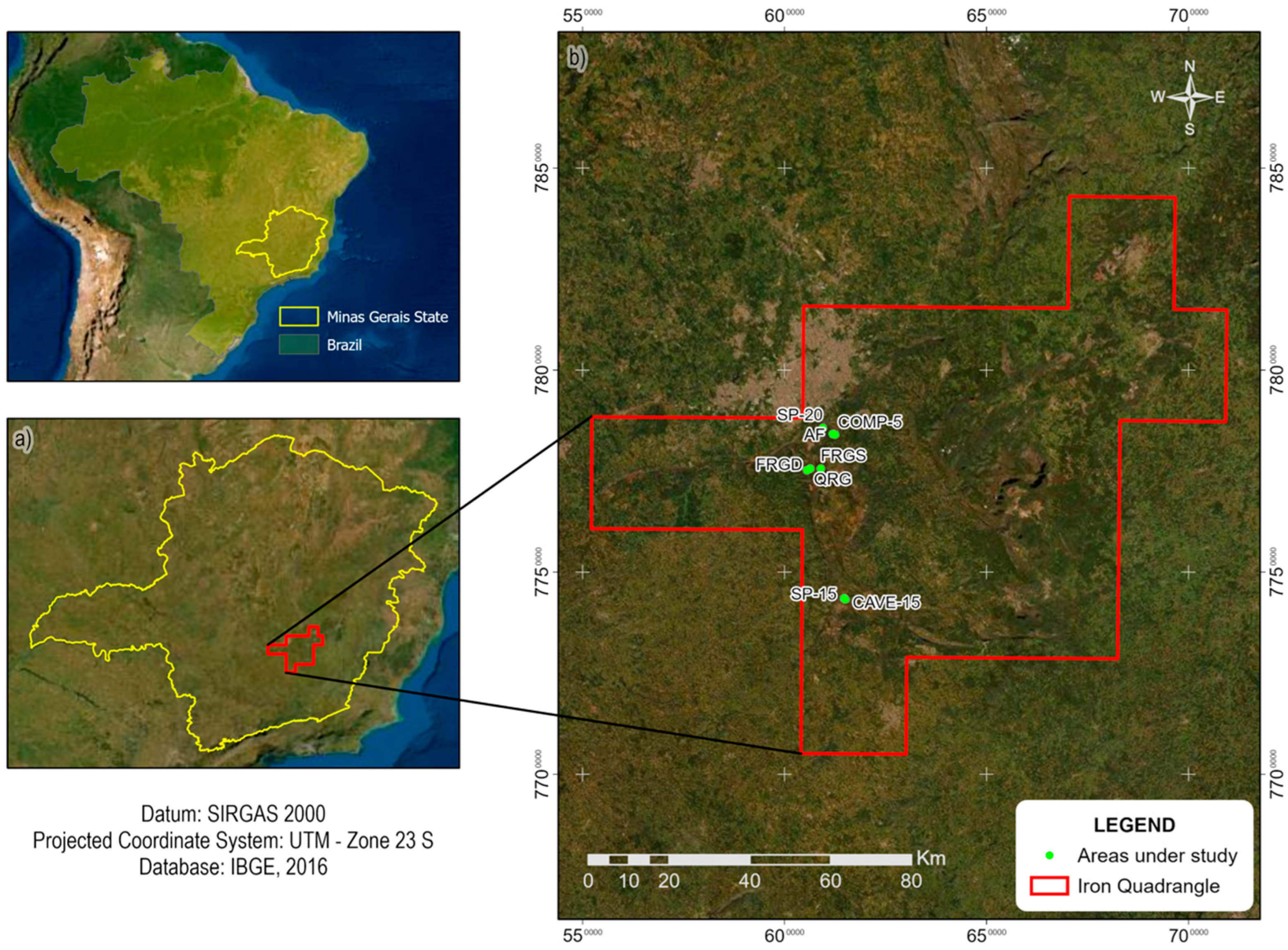

Table 1.
Location, geographic coordinates, and mean altitude of the study areas.
| Area | Localization | Latitude | Longitude | Altitude (m) |
|---|---|---|---|---|
| FRGS | CTF Miguelão | 20°06'49.5" O | 43°57'28.2" S | 1482 |
| FRGD | Serra da Calçada | 20°06'49.7" O | 43°58'58.8" S | 1277 |
| QRG | Serra da Calçada | 20°07'01.4" O | 43°59'24.4" S | 1459 |
| AF | Mata do Tumbá | 20°02'07.3" O | 43°55'48.5" S | 1014 |
| COMP-5 | Mata do Tumbá | 20°02'14.6" O | 43°55'27.1" S | 967 |
| SP-15 | Viaduto das Almas | 20°24'11.6" O | 43°54'00.4" S | 1330 |
| CAVE-15 | Viaduto das Almas | 20°24'20.1" O | 43°53'51.8" S | 1322 |
| SP-20 | Mina da Mutuca | 20°01'21.7" O | 43°57'12.2" S | 1122 |
The four mine-affected areas differed in their previous history. The COMP-5 area originally had a native forest that was logged for more than 30 years. The area was never mined, but its recovery was legally required as a compensatory measure for mining activities performed elsewhere. Area SP-20 was located on the slopes of a sterile pile. The slopes had an average inclination of 26° and a ramp length of approximately 40 m. The SP-15 area was located on top of a sterile pile with flat relief, and the materials deposited in it came from CAVE-15, which was located on the eastern side of the pile.
The recovery work in areas SP-15, SP-20, and COMP-5 included seeding exotic species of grasses and legumes and subsequent planting of seedlings of native species. Area SP-15 received a 20-cm thick topsoil layer prior to planting. Only exotic grass and legume species were planted to cover the substrate in the CAVE-15 site.
2.2. Soil and vegetation analysis
Four 10 x 10 m plots were delimited in each area to collect soil samples and determine vegetation attributes. Composite soil samples were obtained by homogenizing four simple samples collected randomly from each plot. Due to shallow soil depths in FRGS and QRG, only soil from 0-2.5 cm deep was sampled. In the other areas, sampling was carried out on separate 0-2.5 cm and 2.5-10 cm layers. The samples were ground in a porcelain mortar and passed through a 2-mm sieve. The air-dried fine soil was obtained with the soil that had passed through the 2-mm sieve, and rock content (Rockiness) was calculated based on the mass of soil retained in the 2-mm sieve.
Analyzed soil physical attributes selected included rockiness, bulk density (ρb), particle density (ρp), clay content (Clay), silt content (Silt), fine sand content (FS), coarse sand content (CS), total porosity (TP), and available water content (AW). Bulk density was determined with a reformed sample packed into a 10 cm³ pipe, dividing the soil mass previously dried at 105 ºC for 24 h by the pipe volume. This method was adapted due to the difficulty of collecting volumetric rings in unstructured, shallow, and rockiness soils. Particle density was obtained by the volumetric flask method (Viana et al., 2017). The particle size analysis was performed using the pipette method (Donagemma et al., 2017). The total porosity was indirectly determined from the values of bulk density and particle density, as 1 – bulk density/solid density (Almeida et al., 2017). The gravimetric available water content was determined by subtracting the moisture estimated at field capacity (i.e., -10 kPa) from the moisture estimated at the wilting point (i.e., -1,500 kPa; Teixeira and Behring, 2017).
Measured chemical attributes were pH in water (pH), available phosphorus content (Pav), available potassium content (K), exchangeable calcium content (Ca2+), exchangeable magnesium content (Mg2+), exchangeable aluminum content (Al3+), potential acidity (H+Al), total organic carbon content (TOC), remaining phosphorus content (P-rem) (Alvarez V. et al., 2017), effective cation exchange capacity (t) potential cation exchange capacity (T), aluminum saturation (m), P/P-rem ratio, and total contents of Al, As, Cd, Co, Fe, Mn, Ni, and Pb. The pH was determined by the potentiometer method using a soil:water ratio of 1:2.5 (Teixeira et al., 2017b). K and P were extracted with a Mehlich-1 solution, K being determined by flame spectrophotometry and P by UV-Vis spectrophotometry (Teixeira et al., 2017c). The exchangeable contents of Al3+, Ca2+, and Mg2+ were extracted with a 1 mol L-1 KCl solution, with Al3+ being measured by titrametry and Ca2+ and Mg2+ measured by atomic absorption spectroscopy (Teixeira et al., 2017a). Potential acidity was determined by extraction with 0.5 mol L-1 calcium acetate buffered at pH 7.0, followed by titration (Campos et al., 2017a). The remaining phosphorus content was obtained using the 1:10 ratio of soil with a 0.010 mol L-1 CaCl2 solution containing 60 mg L-1 of P (Alvarez V. et al., 2017). The total organic carbon content was obtained by dry combustion in a Shimadzu SSM 5000-A COT-L brand analyzer (Carmo and Silva, 2012). With these results, we determined the effective and potential cation exchange capacity (Teixeira et al., 2017d), aluminum saturation (Campos et al., 2017b), and the P/P-rem ratio.
The total contents of Al, As, Cd, Co, Fe, Mn, Ni, and Pb were obtained by semi-open acid digestion with aqua regia (HCl:HNO3, 3:1, v v-1), according to the German standard DIN 38414-S7, described by Guerra et al. (2013). Elemental quantification was performed by inductively coupled plasma optical emission spectroscopy (ICP-OES). The certified sample SS-1 EnviroMATTM- Soil Contaminated was used in each digestion. Each element's detection and quantification limits were calculated as described in the Eurachem laboratory guide (Magnusson and Örnemark, 2014).
The measured soil biological attributes were microbial biomass carbon (MBC), microbial biomass nitrogen (MBN), soil basal respiration (SBR), metabolic quotient (qCO2), and microbial quotient (qMIC). The MBC and MBN were extracted by the irradiation-extraction method (Ferreira et al., 1999) and were then quantified by titration following Tedesco et al. (1985). The accumulated C-CO2 content was evaluated from a respirometry test conducted under controlled conditions (25 ± 1 °C, in the dark), following Stotzky (1965). Respirometry was performed with 50 g of soil at a moisture equivalent to 70% of field capacity placed in 600 mL glass jars with screw caps containing a central septum. Gas samples were collected from the jar headspaces with 60 mL syringes at the beginning of the test and then after 12, 24, 48, 96, 192, 288, 384, and 504 h. The pots were opened and ventilated for 15 min after each collection. The CO2 content in the air syringes was determined using cavity ring-down spectroscopy (CRDS). The carbon associated with the accumulated CO2 (C-CO2 accumulated, in mg kg-1 of soil) was calculated by the sum of the C-CO2 contents obtained in each period. The SBR (mg kg-1 h-1) was determined using the equation:
where t is the total duration of the test (h).
The qCO2 was determined by the relationship between SBR and MBC (Anderson and Domsch, 1993). The qMic was obtained by the ratio between MBC and TOC (Anderson and Domsch, 1989).
Measured vegetation attributes included soil cover (COV) and estimated vegetation volume (VOL). These attributes were selected as they can be obtained in a low-cost and straightforward way. Small-format aerial images (SFAI), using a DJI Phantom 4 Professional drone (quadcopter) coupled with a 4K full resolution camera, was used to obtain the vegetation attributes. The georeferenced images were processed in the Agisoft Metashape® software to obtain orthorectified images of the area, and the images of each plot were cut using the ArcGis® software.
The COV (%) of each plot was determined in ArcGis® from images with Modified Photochemical Reflectance Indices (MPRI) (Barbosa et al., 2019), and were constructed by the red and green bands of images. The digital terrain model (DTM) and the digital surface model (DSM) were generated in the Agisoft Metashape® software to estimate the vegetation volume (VOL). The VOL (m3/plot) is the result of the difference between DTM and DSM.
2.3. Statistical Analysis
Since there were results for two soil layers for some areas and only one layer for other areas, we chose to do a weighted average by the thickness of the soil layers to obtain only one set of indicator values for all areas.
Pearson's correlation analysis was performed for all attributes, ensuring the suitability of the data to perform the Principal Component Analysis (PCA), following the guidelines of Figueiredo Filho and Silva Júnior (2010). Then, the data for all attributes were standardized by the mean and standard deviation so that scale differences did not influence the principal components (Jolliffe and Cadima, 2016). The PCA was used to select and group indicators and show their relationship with the sampled areas. Finally, we used permutational multivariate analysis of variance (PERMANOVA) to test for significant differences between properties of the different reference areas (α = 0.05). PERMANOVA is an adapted ANOVA for a matrix of distances, calculated by the Jaccard method, and the Non-Metric Multidimensional Scaling (nMDS) result shows stress values.
Statistical analyzes were performed in the R software (R Core Team, 2022), using the Hmisc, permute, lattice, vegan, and factoextra packages.
2.4. Indicators selection
The PCA was carried out in four data groups, with each group comprised of one reference area and the four recovery areas. This strategy made it possible to infer the proximity between indicator values in the recovery areas and each reference area.
The criterion for selecting PCs was similar to the one used by Bhardwaj et al. (2011). We considered only PCs with eigenvalues > 1 (Kaiser's criterion), which identifies PCs that explain more of the total variance in the data compared to the original variable (Figueiredo Filho and Silva Júnior, 2010). We then selected attributes within each PC with loads (r) ≥ 0.80 (Borges, 2013). However, we wanted to make sure that we retained at least one parameter related to vegetation and therefore selected the vegetative indicator with the highest load if none of them exceeded 0.80. We applied the PCA several times in each group until no further exclusion of indicators was possible. The initial dataset used for each new PCA application was the group of variables selected in the previous PCA.
2.5. Recovery Quality Index (RQI)
After selecting the relevant indicators, we calculated the recovery quality index (RQI) for each grouping of restored areas and individual reference areas. Here, we calculated the relative weight of individual parameters (Wi), ensuring that the sum of all weights equaled 1, as specified by Borges (2013):
where Rij is the attribute charge (i.e., load) i on component j, Fj is the component eigenvalue j, i is the attribute index, j is the index for components with eigenvalues > 1, and n is the number of selected indicators.
The indicators scores (Pi) used in the RQI calculations were standardized to assume values between 0 and 1, according to methodologies adapted from Bhardwaj et al. (2011) and Borges (2013). These authors determined soil quality indexes focused on fertility and productivity. Our goal in the present study was to compare degraded areas with reference areas that were not actively managed (e.g., no agronomic or active forest management practices). In this way, we assumed that the results obtained in the reference areas are the optimal values to be achieved by the areas under-recovery.
The indicators in the reference area in each group received a score equal to 1, which is considered the recovery process's goal. When the indicators in the areas under recovery had values lower than those observed in the reference area, the "more is better" function was considered (adapted from Wymore, 1993), and, therefore, the value of the area under recovery was divided by the indicator's value in the reference area. In the inverse situation, it was considered "less is better" function, and the indicator's value in the reference area was divided by the value obtained in the area under recovery.
The RQI was then calculated as the sum of the score of each indicator (Pi) multiplied by its relative weight (Wi) according to the additive model of Karlen et al. (1994), adapted by Bhardwaj et al. (2011):
In each group, the reference area has an RQI value of 1, and the recovery areas had values < 1. The closer to 1, the closer the recovery conditions to the reference area, especially from the pedological point of view.
3. Results
3.1. Soil attributes and vegetation parameters
The descriptive results of all attributes and parameters determined in reference areas are shown in Table S1, and results for all mined areas under recovery are shown in Table S2 (Supplemental Material). The results of the most important attributes and or parameters, selected by PCA analysis and occurring in at least three of the four groups formed, are presented in Figure 2. Seven of the ten indicators were soil physical attributes, two were soil chemical attributes, along with one vegetative parameter. Most areas had low variability of selected indicators, except for the CAVE-15 recovery site and the FRGS reference site.
Figure 2.
Distributions for the attributes identified as being important by principal component analysis (PCA) for the eight study areas: (a) FRGS: Ferruginous rupestrian grassland with sparse vegetation; (b) FRGD: Ferruginous rupestrian grassland with dense vegetation; (c) QRG: Quartzite rupestrian grassland; (d) AF: Atlantic Forest; (e) COMP-5: Environmental compensation area under-recovery for five years with dense and medium-sized vegetation; (f) SP-15: Sterile pile in recovery for 15 years; (g) CAVE-15: Cave in recovery for 15 years; (h) SP- 20: Sterile pile in recovery for 20 years.
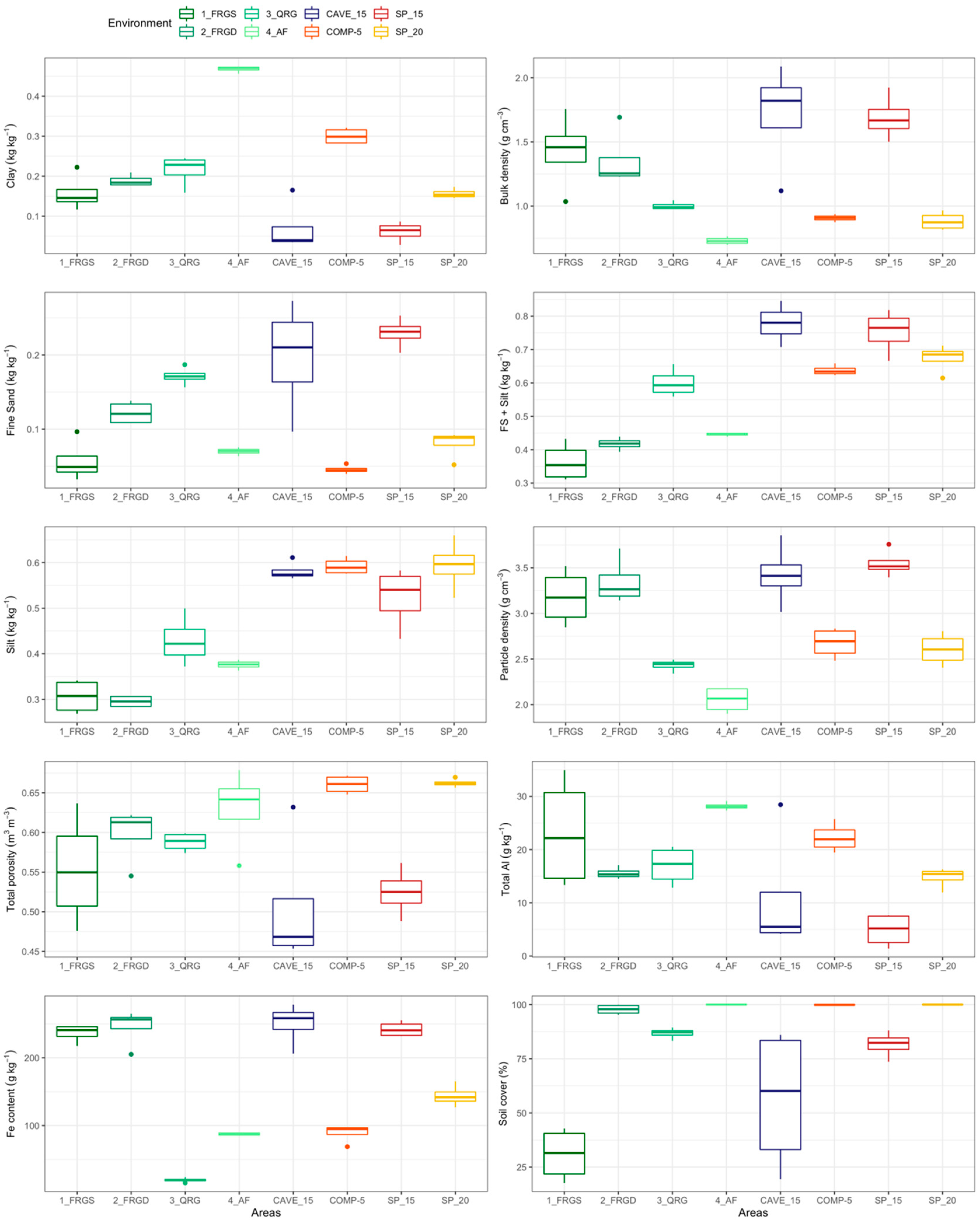
Only the clay content and bulk density attributes were selected in all groups. The clay contents ranged from 0.04 to 0.47 kg kg-1, and the bulk density ranged from 0.70 to 2.09 g cm-3. Among the reference areas, ferruginous rupestrian grassland had the lowest clay content and the highest bulk density values. The area under Atlantic Forest has the highest clay content and the lowest bulk density values. The main differences between the areas under recovery and the reference areas were found for the fine sand + silt content and silt content. There were notable differences between the reference areas for most indicators, even among the ferruginous rupestrian grassland areas, emphasizing the importance of choosing the appropriate reference area for monitoring areas under recovery. Most areas had soil cover COV > 75%, an important condition for the recovery of these environments mainly to avoid erosive processes.
3.2. Selection and weighting of indicators
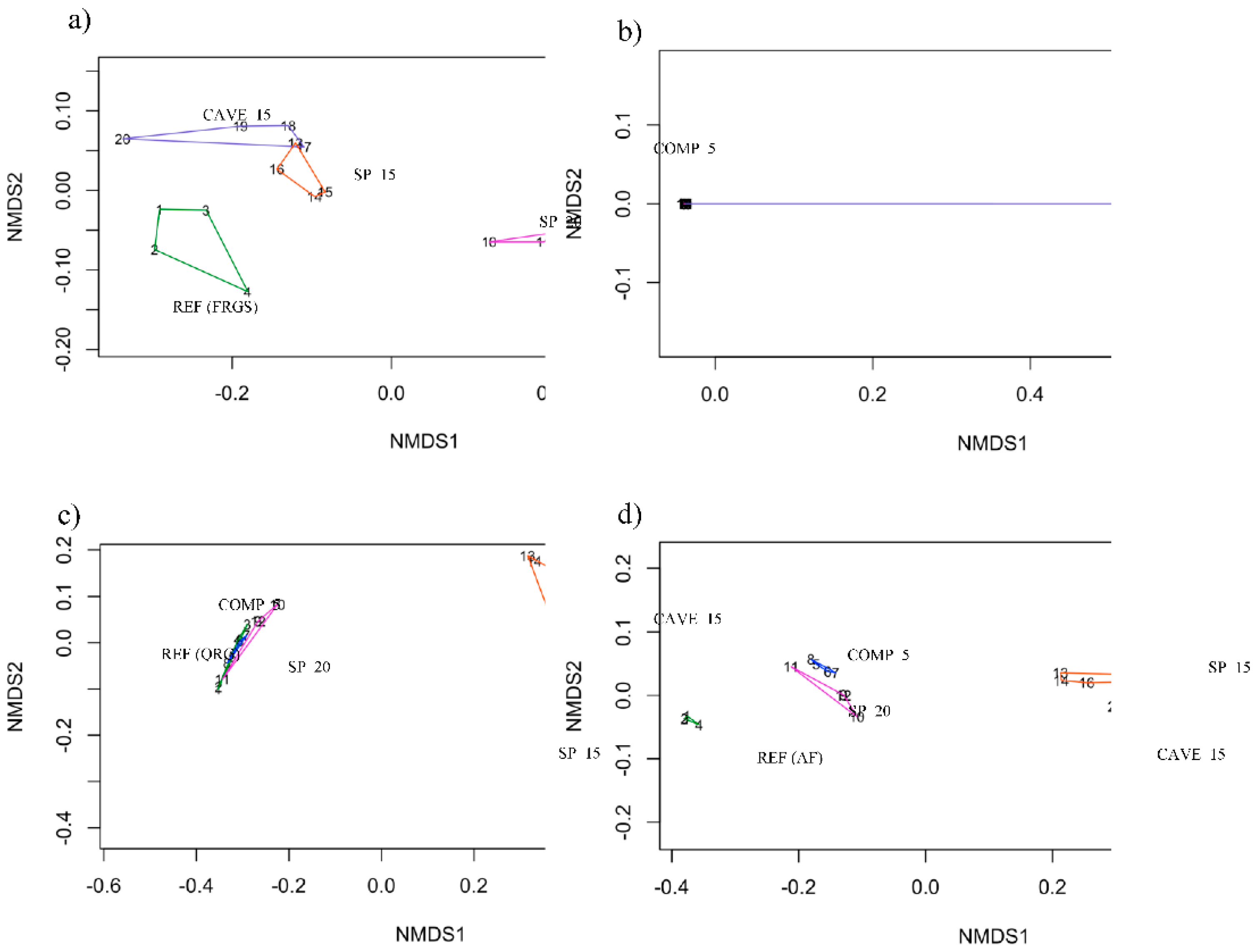
Indicators selected by PCA analysis for each group are shown as vectors in biplot graphics, where dots with the same color represent plots from the same site. Totals of 8, 7, 18, and 20 indicators were respectively selected in Groups 1, 2, 3, and 4 (Figure 3). The restored sites differed from one another and from most reference sites. The CAVE-15 and SP-15 sites were statistically similar and were closer to the reference FRGS (Figure 4a), according to the PERMANOVA analysis (p<0.05). The number of variables selected in Group 2 (FRGD as reference) was very small (7), being insufficient to perform PERMANOVA by the Jaccard method (Figure 4b). The COMP-5 area had statistically similar attributes to SP-20, and both were closely related to QRG (reference), whereas the CAVE-15 and SP-15 sites were similar to one another but were distinct from the others (Figure 4c). The CAVE-15 and SP-15 were also more similar to one another but distinct from the other sites when AF was the reference (Figure 4d).
Figure 3.
PCA results with relationships between selected indicators for the restored sites compared to the (a) FRGS: Ferruginous rupestrian grassland with sparse vegetation; (b) FRGD: Ferruginous rupestrian grassland with dense vegetation; (c) QRG: Quartzite rupestrian grassland; (d) AF: Atlantic Forest reference sites.
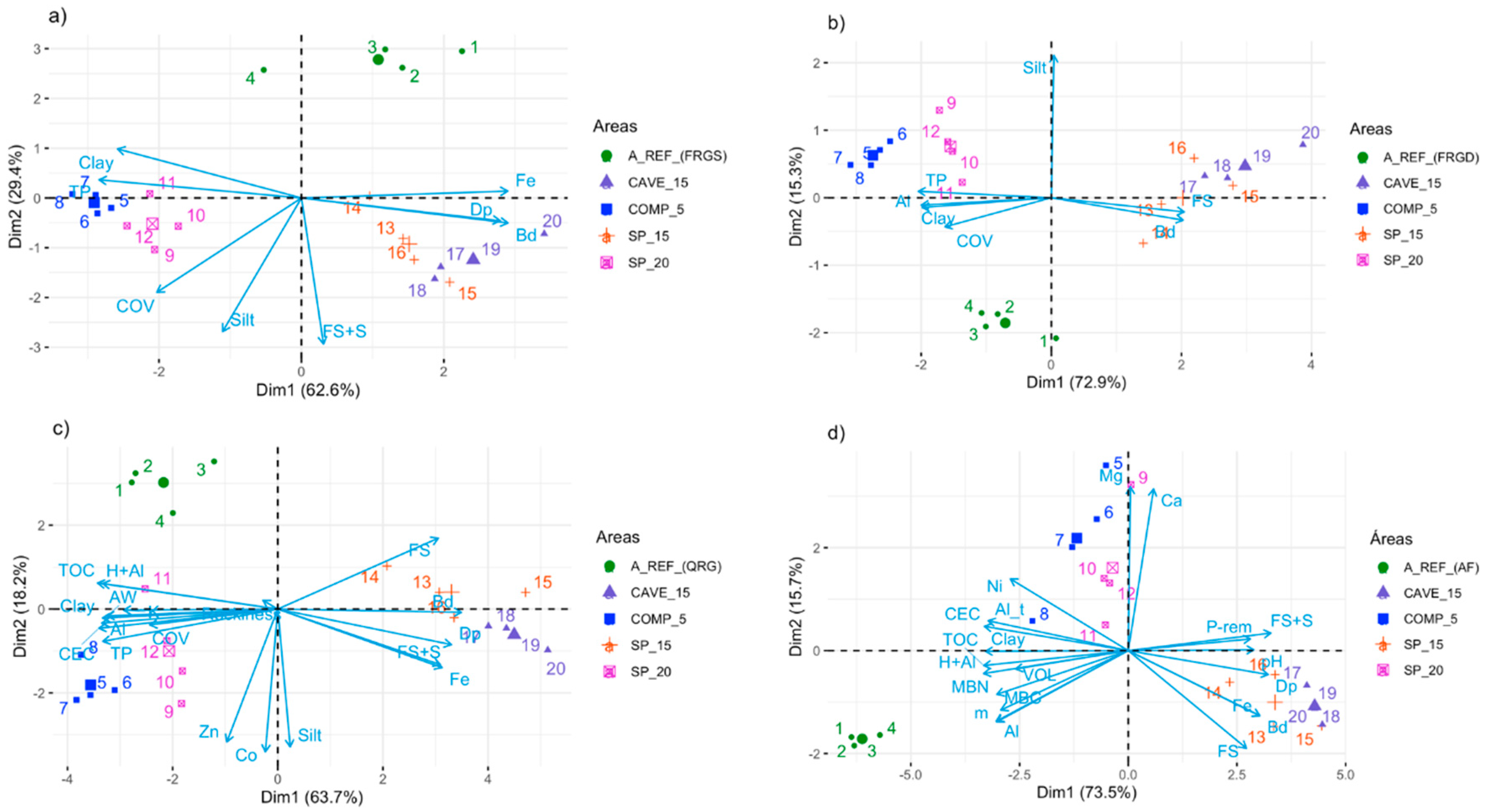
Figure 4.
Result of the PERMANOVA analysis for the restored sites compared to the (a) FRGS: Ferruginous rupestrian grassland with sparse vegetation; (b) FRGD: Ferruginous rupestrian grassland with dense vegetation; (c) QRG: Quartzite rupestrian grassland; (d) AF: Atlantic Forest reference sites.
Figure 4.
Result of the PERMANOVA analysis for the restored sites compared to the (a) FRGS: Ferruginous rupestrian grassland with sparse vegetation; (b) FRGD: Ferruginous rupestrian grassland with dense vegetation; (c) QRG: Quartzite rupestrian grassland; (d) AF: Atlantic Forest reference sites.
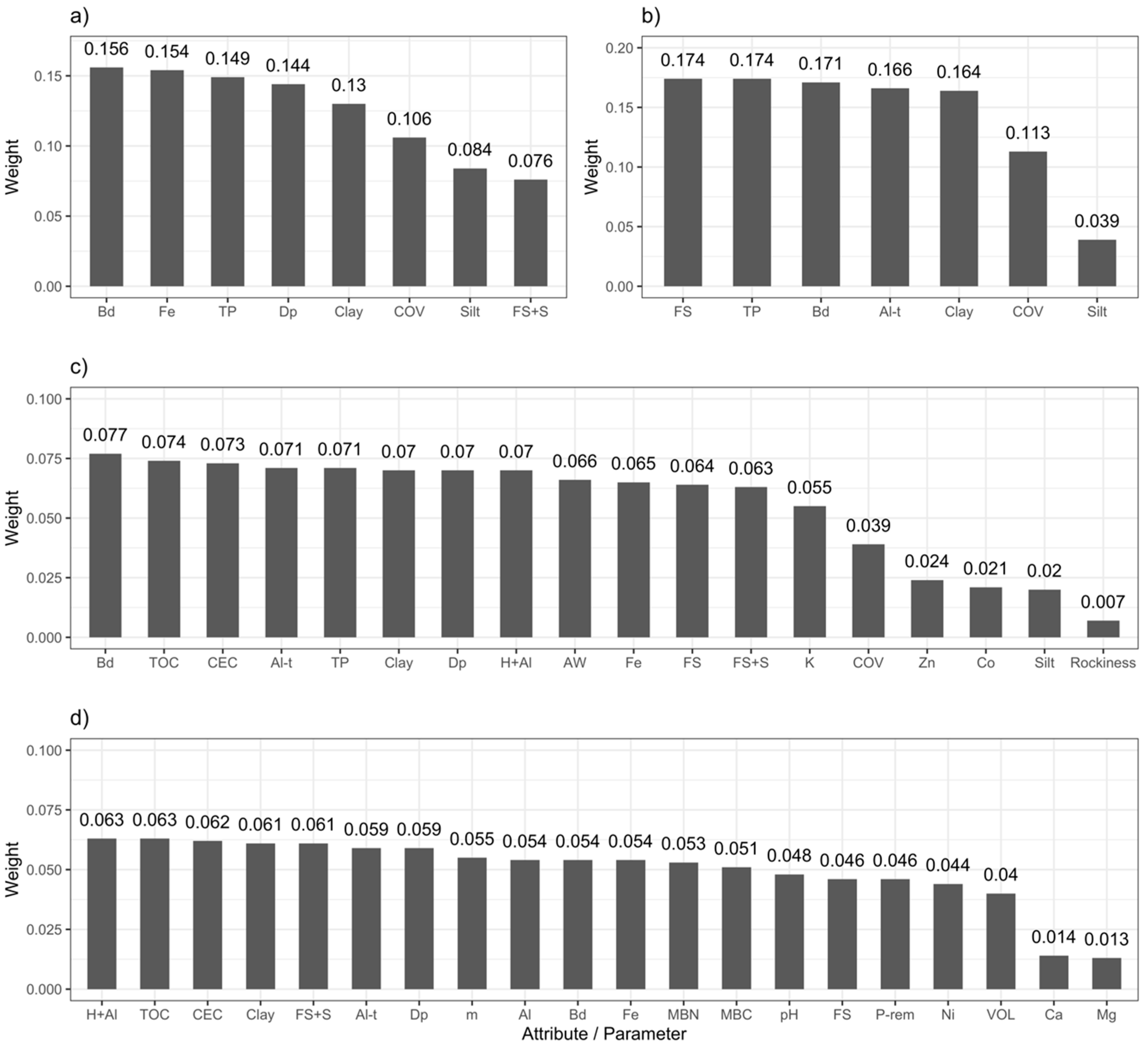
The soil physical indicators were the most important for the composition of the RQI when FRGS was used as the reference. The individual weights (Wi) showed that b had the greatest weight, followed by total Fe content, TP, p, and clay content (Figure 5a). Physical indicators were also the most important for RQI when FRGD was used as the reference, with similar weights for the five most relevant indicators (FS, TP, b , total Al content, and clay) (Figure 5b). For the third group, when QRG was used as the reference, 18 indicators were selected. This relatively large number of selected indicators resulted in smaller individual contributions for each attribute (Figure 5c). Once again, physical indicators tended to have high weight, but in this comparison, chemical indicators were also important. The ρb, TOC, and T indicators had the highest weights. Finally, when the AF was used as the reference, chemical indicators were selected in greater quantity and had the greatest weights in the composition of the RQI (Figure 5d). Chemical indicators altogether represented 57.5% of the total contribution, twice the contributions of physical indicators (28.1%).
Figure 5.
Weights (Wi) calculated for selected indicators from the restored sites compared to the (a) FRGS: Ferruginous rupestrian grassland with sparse vegetation; (b) FRGD: Ferruginous rupestrian grassland with dense vegetation; (c) QRG: Quartzite rupestrian grassland; (d) AF: Atlantic Forest reference sites.
3.3. Restauration Quality Index (RQI)
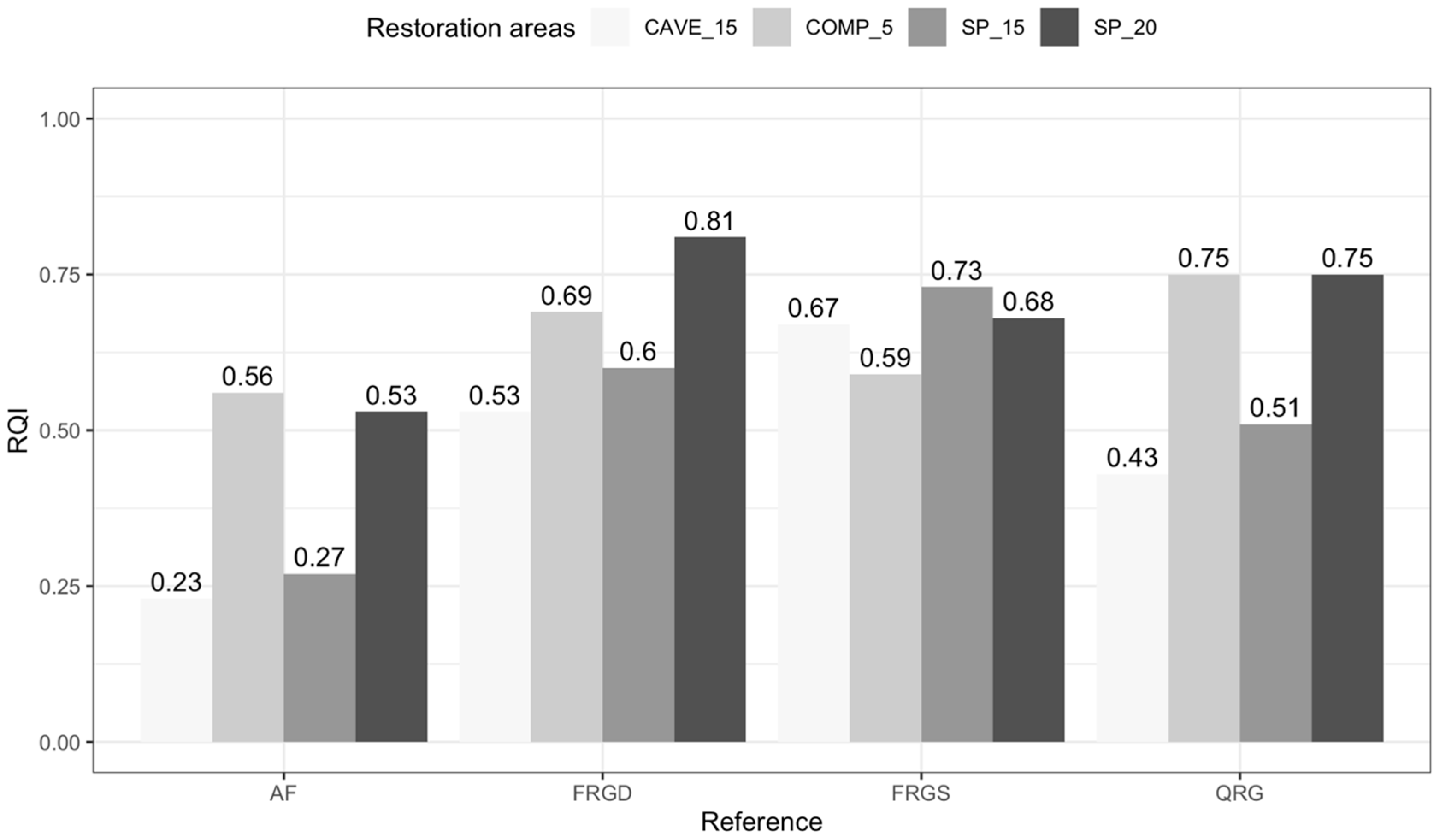
The COMP-5 and SP-20 areas presented the highest RQI values, indicating environmental conditions closer to the different reference areas (Figure 6). The COMP-5 area showed high RQI values even with a relatively short recovery time because it is an area where there was only vegetation removal and, therefore, limited soil disturbance. The higher RQI values observed in SP-20 were likely due to the longer time in the recovery process. In general, the areas undergoing recovery were more similar to the FRGS, with values close to 0.67. Using the AF site as a reference area, in contrast, resulted in the lowest RQI values.
Figure 6.
Recovery Quality Index (RQI) values for sites under-recovery compared to each reference site. The reference areas (FRGS: Ferruginous rupestrian grassland with sparse vegetation; FRGD: Ferruginous rupestrian grassland with dense vegetation; QRG: Quartzite rupestrian grassland; and AF: Atlantic Forest) have RQI equal to 1. The areas under-recovery are COMP-5: Environmental compensation area under-recovery for five years with dense and medium-sized vegetation; SP-15: Sterile pile in recovery for 15 years; CAVE-15: Cave in recovery for 15 years; and SP- 20: Sterile pile in recovery for 20 years.
4. Discussion
4.1. Development and Interpretation of Recovery Quality Index (RQI) values
Our main objective in this study was to use different soil- and vegetation-related parameters to inform recovery quality. We prioritized soil in our set of indicators due to its importance in controlling water, gas, and energy flows in lands that are being reconstructed after logging or mining activities (Melo Filho et al., 2007). However, previous research on soil quality indexes has primarily focused on production systems and the surrounding agrosystems (Andrews and Carroll, 2001; Bhardwaj et al., 2011; Karlen et al., 1994; Melo Filho et al., 2007). By comparison, little work has been done to evaluate recovery efforts by comparing rehabilitated lands with reference areas that had little or no anthropogenic modification (SER, 2004).
The RQI values can be interpreted to reveal possible factors influencing ecosystem recovery during restoration. For example, the indicator values in the recovery areas were lower than in the reference areas. This result indicates a “more is better” condition, where higher values of these indicators will bring more benefits to the recovery process by moving it to a condition closer to the reference. The “more is better” function is commonly used for indicators that, by assuming high values, mean an increase in soil fertility and productivity. We note that it is also theoretically possible to have indicator values that are greater in the area than in the reference area. This result would indicate a “less is better” function, and smaller values will be better because they are closer to the reference (Melo Filho et al., 2007). In areas undergoing ecological restoration, the increase in fertility does not necessarily denote a more significant similarity between the areas under recobery and a reference area in terms of quality. The reference areas used in this study are characterized by their low natural fertility (Ribeiro et al., 2017; Daws et al., 2021). Therefore, RQI values closer to 1 indicate “optimal conditions” relative to the references.
The function types of the indicators selected to integrate the RQI have not been widely presented in the literature, especially within the IQ region. For this reason, we consider that the functions presented a linear behavior for all indicators (Bhardwaj et al., 2011; Borges, 2013), although the indicators often show a sine wave function (Karlen et al., 1994; Melo Filho et al., 2007). However, it is reasonable to assume that values central to the sinusoidal curve are similar to a straight line, allowing the use of this methodology to obtain good approximations.
4.2. Recovery Quality Index of areas impacted by mining
Two of the areas evaluated are sterile piles (SP), excavated materials (soil, subsoil, rock) naturally occurring in the extraction area, without economic value, which is usually arranged in piles (Lima et al., 2020; Silva et al., 2006). Therefore, the constitution of SP varies according to the nature of the material provided. The SP-15, specifically, was formed by barren from the neighboring area CAVE-15. Thus, the proximity of location and constitution between them explains the similarity between the attributes evaluated in these areas.
In Group 1, having FRGS as the reference area, SP-15 had the highest RQI due to the proximity between these areas in terms of b, Fe, TP, and p values. As mentioned before, when considering rupestrian grassland as reference areas, it is necessary to understand that more fertile and productive environments are not necessarily closer to them in terms of quality. The high values of b and p in FRGS are the effects of higher Fe contents, which are abundantly found in Plinthosols under ferruginous rupestrian fields in the region, associated with the occurrence of ferruginous crusts (Coelho et al., 2017; Leonardi, 2014). High values for these indicators are also expected in FRGS, SP-15, and CAVE-15, as it is a source area for the Fe ore extraction, and its soil is subject to compaction, and in SP-15, which includes materials from a nearby deposit. In this group, the clay content was important for SP-20 to present a better recovery quality index compared to CAVE-15 since the values of this indicator in FRGS and SP-20 were very similar. Time is also an essential factor for obtaining higher RQI values.
The areas under restoration in Group 1 showed greater soil cover than FRGS, decreasing the similarity between them and the reference area. In fact, in the rupestrian grasslands, shallow and dystrophic soils with high amounts of ferruginous nodules control the vegetation cover distribution, subjecting the vegetation to a selection pressure (Pereira, 2010; Schaefer et al., 2008). Thus, in FRGS, an area in which these characteristics are highly expressive, the vegetation is distributed according to the variation of soil attributes, being naturally sparse.
In Group 2 (ferruginous rupestrian grassland with dense vegetation as reference), six of the eight indicators of Group 1 were selected, showing the similarity between FRGS and FRGD since both areas are rupestrian grassland. However, these areas mainly differed by soil thickness, pedogenetic process, relief, vegetation size, and density. The SP-20 had the highest RQI, followed by COMP-5, when FRGD was used as the reference. This result can be explained by the similarity of clay content, Al content, and TP between these areas and the reference. In IQ Haplic Cambisols, soil occurring in COMP-5, high clay contents are frequently ,measured (Coelho et al., 2017). The higher clay content and the lower FS+S contents in COMP-5 and SP-20 were possibly related to a better soil structure, which was reflected in the highest TP values. In addition, the high soil Al content was essential to assess these areas, which can be explained by the occurrence of siliciclastic rocks that constitute the geological group Nova Lima (Costa, 2003; Rossi, 2014).
When quartzite rupestrian grassland was used as the reference site (Group 3), COMP-5 and SP-20 presented the same RQI value, surpassing the other areas under-recovery. Although COMP-5 and SP-20 have very different restoration times, the soil has been preserved in COMP-5 makes this area have a recovery quality similar to SP-20, with 20 years in the restoration process. The most relevant indicators in this group were b, TOC, CEC, and the Al content indicating that the organic matter content and soil mineralogy represent the greatest similarity between recovery areas and the reference. Although quartzite rupestrian grassland soils are naturally low in carbon (Benites et al., 2003), in QRG, the TOC was higher in the areas under recovery. The reason is the direct action of degradation by mining on the soil organic content (IBAMA, 1990). The highest TOC contents were observed in COMP-5 and SP-20.
In QRG, CEC is possibly associated with organic matter, as organic matter plays an essential role in generating charges in quartzite rupestrian grassland soils (Benites et al., 2003). The higher organic matter content and clay content in COMP-5 and SP-20 corroborate the CEC values found, higher than observed in QRG. The quartzite rupestrian grassland soils of the Caraça group originate from quartzite and phyllite rocks (Costa, 2003; Rossi, 2014), justifying the high Al content observed in QRG. The high Al content in COMP-5 can also be explained by its geology, with siliciclastic rocks (Costa, 2003; Rossi, 2014).
The most significant number of indicators was selected in Group 4 (Atlantic Forest as reference), showing greater heterogeneity of the AF environment as a reference area. The higher weights assigned to the chemical indicators in this group is probably related to organic matter, which was greater in AF than the other reference sites. In this group, a forest under deeper soils was used as a reference, a situation very different from the areas under rupestrian grassland. Ferruginous rupestrian grassland comprises extensions of greater interest to mining ventures as it develops on Fe deposits (Torres Ribeiro and Freitas, 2010). Thus, rupestrian environments usually suffer greater degradation and, therefore, it is to be expected that previously explored areas under-recovery do not have historical trajectories related to forests and may contribute to lower RQI values in the short term. However, thick substrate layers are usually deposited over mined areas for recovery, favoring long-term forest establishment.
In Group 4 (AF as reference), COMP-5 had the highest RQI, followed by SP-20. The proximity between COMP-5 and AF is not just about quality but also about spatial proximity. The COMP-5 has the same history of vegetation cover (Forest) as AF, and these areas have the same soil (Cambisol), therefore with similar selected indicator results. It is common to find high organic carbon levels in forest environments arising from animal and plant waste (Selle, 2007). Thus, forests with dense vegetation, as in AF, produce a more significant amount of plant residues and, consequently, higher levels of organic matter. In COMP-5, where less degradation and vegetation provide greater ground cover, TOC is the largest and closest to AF in recovery areas. SP-20 also showed high TOC content, revealing the importance of rapid vegetation establishment and the beginning of the biogeochemical cycle for soil carbon incorporation, resulting in recovery quality close to half of the reference condition, just 20 years after the beginning of the restoration process.
4.3. Recovery Quality Assessment
The soil attributes were determinant for the evaluations of the recovery quality, presenting the biggest weights, and on the other hand, the vegetation parameters had the smallest contribution. In general, SP-20 had the highest RQI values, regardless of the reference area. The highest RQI value in SP-20 was obtained in group 2, indicating that this area, which has the longest time in the restoration process, is more similar to FRGD. Although the vegetation attributes had the lowest weights, the main differences existing between SP-20 and FRGD were obtained for these attributes. Physical and chemical soil properties are strongly related to the diversity of plant species occurring in the different habitats of rupestrian grassland (Carvalho et al., 2014). However, the physical and chemical characteristics of the Technosols in the area undergoing recovery did not have similar characteristics as the natural condition, at least in the short term.
The SP-15 and CAVE-15 areas, located in an originally ferruginous environment, had a higher RQI in Group 1; thus, they are currently more similar to FRGS. In other words, these areas showed better recovery quality only when compared to an area with high Fe content, little vegetation cover, and poorly developed soil. Due to the relevance of the physical indicators in Group 1, the particle size and soil structure, with poorly developed soil, were essential to obtain the most significant similarity with the FRGS.
COMP-5 showed high recovery quality index when QRG was the reference. The main contributions to verifying the similarity between these areas were with the indicators ρb, Al content, and indicators related to organic matter. COMP-5 showed the highest RQI values when chemical indicators have greater weight, especially organic matter indicators when QRG and AF are used as reference areas. Thus, the increase in organic matter in areas under restoration can improve the recovery quality index in situations where QRG and AF are reference areas or restoration goals.
The RQI values obtained were low, regardless of area and restoration time, which shows that the ecological restoration process is slow and can last for many years (SER, 2004). The initial energy input (fertilizers, seedlings, irrigation) in the different areas was sufficient to reach RQI values close to the current values, and its increment should be very slow. Twenty years of recovery restoration of mined areas is still little compared to the time needed for the restoration quality to be satisfactory. Also, RQI values for different ecological restoration levels need to be defined. Periodic assessments adopting this methodology will be essential to assess the trajectory and the need for interventions.
In some situations, it is more interesting for an area under recovery to maintain its trajectory, even if it differs from the state prior to degradation, such as COMP-5. Under these conditions, new environmental services can be established, expected in drastically altered environments, such as mined areas. Therefore, comparing the areas under-recovery and the reference areas during monitoring can help decision-making regarding the need for interventions to speed up the recovery process.
When the goals of the recovery plan are the ecological restoration of rupestrian grassland, complex and unique ecosystems, and with the presence of endemic or endangered species (Schaefer et al., 2015), phytosociological attributes are essential. Thus, the RQI can be changed as more vegetation parameters are used, mainly related to phytosociology, obtaining a complete evaluation of the recovery process.
5. Conclusions
Our study aimed to assess the recovery quality of degraded areas by iron mining by developing a Recovery Quality Index (RQI) using soil and vegetation indicators. The 20-year-old sterile pile showed the best recovery quality indexes regardless of the reference area considered, showing that time is essential for the recovery of important soil and vegetation properties. The recovery quality of this pile is higher when Ferruginous Rupestrian Grassland with dense vegetation was the reference area. The sterile pile and the pit under-recovery for 15 years had a higher recovery quality index when Ferruginous Rupestrian Grassland with sparse vegetation was the reference, mainly due to the importance of physical indicators. Finally, the recovery quality index of the compensation area under-recovery for five years was higher when the Quartzite Rupestrian Grassland was the reference due to the similarity of the mineralogical constitution and organic matter content.
The recovery quality index values were similar to all areas with 5 to 20 years in the recovery process, showing that the restoration process is slow in this environment, regardless of the initial characteristics of the area and the restoration techniques used. The monitoring of mined areas is essential for following the index’s evolution over time, showing the trajectory of the area in recovery. The Recovery Quality Index proved to be a tool with great potential to assist in decision-making throughout the process of recovering areas degraded by mining.
Supplementary Materials
The following supporting information can be downloaded at the website of this paper posted on Preprints.org.
Acknowledgments
We thank the company VALE S.A. for funding this research and for all support in the field work. This study was also financed in part by the Coordenação de Aperfeiçoamento de Pessoal de Nível Superior - Brasil (CAPES) - Finance Code 001; and by Fundação de Apoio a Pesquisa de Minas Gerais – Brasil (FAPEMIG) – Finance Code RDP-00001-17. We are especially grateful to José Marangon, Wagner Roberto and Nei Rivello for their efforts in making this work possible.
References
- Almeida, B.G. de, Freitas, P.L. de, Teixeira, W.G., Viana, J.H.M., Donagemma, G.K., 2017. Porosidade, in: Teixeira, P.C., Donagemma, G.K., Fontana, A., Teixeira, W.G. (Eds.), Manual de Métodos de Análise de Solo. Embrapa, Brasília, pp. 82–94.
- Almeida, R.O.P.O., Sánchez, L.E., 2015. Indicadores da qualidade do substrato para monitoramento de áreas de mineração revegetadas. Floresta e Ambient. 22, 153–163. https://doi.org/http://dx.doi.org/10.1590/2179-8087.072714. [CrossRef]
- Alvarez V., V.H., Novais, R.F., Cantarutti, R.B., Teixeira, P.C., Campos, D.V.B. de, 2017. Fósforo remanescente, in: Teixeira, P.C., Donagemma, G.K., Fontana, A., Teixeira, W.G. (Eds.), Manual de Métodos de Análise de Solo. Embrapa, Brasília, pp. 337–342.
- Anderson, T.-H., Domsch, K.H., 1993. The metabolic quotient for CO2 (qCO2) as a specific activity parameter to assess the effects of environmental conditions, such as pH, on the microbial biomass of forest soils. Soil Biol. Biochem. 25, 393–395.
- Anderson, T.-H., Domsch, K.H., 1989. Ratios of microbial biomass carbon to total organic carbon in arable soils. Soil Biol. Biochem. 21, 471–479. https://doi.org/10.1016/0038-0717(89)90117-X. [CrossRef]
- Andrews, S.S., Carroll, C.R., 2001. Designing a soil quality assessment tool for sustainable agroecosystem management. Ecol. Appl. 11, 1573–1585.
- ANM, 2019. Anuário Mineral Brasileiro: Principais Susbtâncias Metálicas 2018. Ano base 2017. ANM, Brasília (DF).
- Barbosa, B.D.S., Ferraz, G.A.S., Gonçalves, L.M., Marin, D.B., Maciel, D.T., Ferraz, P.F.P., Rossi, G., 2019. RGB vegetation indices applied to grass monitoring: a qualitative analysis. Agron. Res. 17, 349–357. https://doi.org/10.15159/AR.19.119. [CrossRef]
- Barrett, K.J., Cannon, J.B., Schuetter, A.M., Cheng, A.S., 2021. Effects of collaborative monitoring and adaptive management on restoration outcomes in dry conifer forests. For. Ecol. Manage. 488, 119018. https://doi.org/10.1016/J.FORECO.2021.119018. [CrossRef]
- Benites, V. de M., Cunha, T.J.F., Ferraz, R.P.D., Caiafa, A.N., Simas, F.N., Mendonça, E. de S., 2003. Caracterização dos solos em duas toposseqüências sobre diferentes litologias em áreas altimontanas na Serra da Mantiqueira. Embrapa Solos, Rio de Janeiro, RJ.
- Bhardwaj, A.K., Jasrotia, P., Hamilton, S.K., Robertson, G.P., 2011. Ecological management of intensively cropped agro-ecosystems improves soil quality with sustained productivity. Agric. Ecosyst. Environ. 140, 419–429. https://doi.org/10.1016/J.AGEE.2011.01.005. [CrossRef]
- Borges, S.R., 2013. Qualidade do solo em áreas em recuperação com forrageiras e cafeeiro pós-mineração de bauxita. Universidade Federal de Viçosa, Viçosa, Minas Gerais.
- Campos, D.V.B. de, Teixeira, P.C., Pérez, D.V., Saldanha, M.F.C., 2017a. Acidez potencial do solo, in: Teixeira, P.C., Donagemma, G.K., Fontana, A., Teixeira, W.G. (Eds.), Manual de Métodos de Análise de Solo. Embrapa, Brasília, pp. 233–237.
- Campos, D.V.B. de, Teixeira, P.C., Saldanha, M.F.C., Pérez, D.V., 2017b. Percentagem de saturação por alumínio, in: Teixeira, P.C., Donagemma, G.K., Fontana, A., Teixeira, W.G. (Eds.), Manual de Métodos de Análise de Solo. Embrapa, Brasília, pp. 245–246.
- Carmo, D.L. do, Silva, C.A., 2012. Métodos de quantificação de carbono e matéria orgânica em resíduos orgânicos. Rev. Bras. Ciências do Solo 36, 1211–1220. https://doi.org/https://doi.org/10.1590/S0100-06832012000400015. [CrossRef]
- Carvalho, F. De, Godoy, E.L., Lisboa, F.J.G., Moreira, F.M.D.S., Souza, F.A. De, Berbara, R.L.L., Fernandes, G.W., 2014. Relationship between Physical and Chemical Soil Attributes and Plant Species Diversity in Tropical Mountain Ecosystems from Brazil. J. Mt. Sci. 11, 875–883. https://doi.org/10.1007/s11629-013-2792-4. [CrossRef]
- Carvalho Filho, A. de, 2008. Solos e ambientes do quadrilátero ferrífero (MG) e aptidão silvicultural dos tabuleiros costeiros. Universidade Federal de Lavras, Lavras, Minas Gerais.
- Coelho, M.R., Vasques, G. de M., Tassinari, D., Souza, Z.R. de, Oliveira, A.P. de, Moreira, F.M. de S., 2017. Solos do Quadrilátero Ferrífero sob diferentes coberturas vegetais e materiais de origem, BOLETIM DE PESQUISA E DESENVOLVIMENTO 264. Rio de Janeiro, RJ.
- Costa, S.Â.D. da C., 2003. Caracterização química, física, mineralógica e classificação de solos ricos em ferro do Quadrilátero Ferrífero. Universidade Federal de Viçosa, Viçosa, Minas Gerais.
- Daws, M.I., Walters, S.J., Harris, R.J., Tibbett, M., Grigg, A.H., Morald, T.K., Hobbs, R.J., Standish, R.J., 2021. Nutrient enrichment diminishes plant diversity and density, and alters long-term ecological trajectories, in a biodiverse forest restoration. Ecol. Eng. 165, 106222. https://doi.org/10.1016/J.ECOLENG.2021.106222. [CrossRef]
- Donagemma, G.K., Viana, J.H.M., Almeida, B.G. de, Ruiz, H.A., Klein, V.A., Dechen, S.C.F., Fernandes, R.B.A., 2017. Análise granulométrica, in: Teixeira, P.C., Donagemma, G.K., Fontana, A., Teixeira, W.G. (Eds.), Manual de Métodos de Análise de Solo. Embrapa, Brasília, pp. 95–116.
- Ferreira, A.S., Camargo, F.A.O., Vidor, C., 1999. Utilização de microondas na avaliação da biomassa microbiana do solo. Rev. Bras. Ciência do Solo 23, 991–996.
- Figueiredo Filho, D.B., Silva Júnior, J.A. da, 2010. Visão além do alcance: Uma introdução à análise fatorial. Opiniao Publica 16, 160–185. https://doi.org/10.1590/S0104-62762010000100007. [CrossRef]
- Fischer, J., Riechers, M., Loos, J., Martin-Lopez, B., Temperton, V.M., 2021. Making the UN Decade on Ecosystem Restoration a Social-Ecological Endeavour. Trends Ecol. Evol. 36, 20–28. https://doi.org/10.1016/J.TREE.2020.08.018. [CrossRef]
- Guerra, M.B.B., Neto, E.L., Prianti, M.T.A., Pereira-Filho, E.R., Schaefer, C.E.G.R., 2013. Post-fire study of the Brazilian Scientific Antarctic Station: Toxic element contamination and potential mobility on the surrounding environment. Microchem. J. 110, 21–27. https://doi.org/10.1016/j.microc.2013.01.007. [CrossRef]
- IBAMA, 2011. Instrução normativa no 04 de 13 de abril de 2011. Estabelece procedimentos para elaboração de Projeto de Recuperação de Área Degradada - PRAD ou Área Alterada, para fins de cumprimento da legislação ambiental. Brasília, , Brasil.
- IBAMA, 1990. Manual Técnico de Recuperação de Áreas Degradadas pela Mineração: Técnicas de Revegetação.
- Jacobi, C.M., Do Carmo, F.F., 2008. The Contribution of Ironstone Outcrops to Plant Diversity in the Iron Quadrangle, a Threatened Brazilian Landscape. Ambio 37, 321–322. https://doi.org/10.1579/0044-7447(2008)37[321:CCPICI]2.0.CO;2. [CrossRef]
- Jolliffe, I.T., Cadima, J., 2016. Principal component analysis: a review and recent developments. Philos. Trans. R. Soc. A Math. Phys. Eng. Sci. 374, 1–16. https://doi.org/10.1098/rsta.2015.0202. [CrossRef]
- Karlen, D.L., Wollenhaupt, N.C., Erbach, D.C., Berry, E.C., Swan, J.B., Eash, N.S., Jordahl, J.L., 1994. Crop residue effects on soil quality following 10-years of no-till corn. Soil Tillage Res. 31, 149–167. https://doi.org/10.1016/0167-1987(94)90077-9. [CrossRef]
- Leonardi, F.A., 2014. O mapeamento, caracterização e datação de perfis laterísticos para identificação e correlação de superfícies geomórficas: estudo de caso do Quadrilátero Ferrífero. Universidade Estadual de Campinas, Campinas, SP.
- Lima, M.T., Tonello, K.C., Leite, E.C., Franco, F.S., Júlia, C., Corrêa, P., 2020. Dinâmica da recuperação ambiental de pilhas de estéril em mineração de calcário por regeneração natural. Eng. Sanitária e Ambient. 25, 11–19. https://doi.org/10.1590/S1413-41522020180571. [CrossRef]
- Liu, Y., Li, H., Huang, S., An, H., Santagata, R., Ulgiati, S., 2020. Environmental and economic-related impact assessment of iron and steel production. A call for shared responsibility in global trade. J. Clean. Prod. 269, 122239. https://doi.org/10.1016/j.jclepro.2020.122239. [CrossRef]
- Magnusson, B., Örnemark, U., 2014. Eurachem guide: The fitness for purpose of analytical methods- A laboratory guide to method validation and related topics, 2nd ed, Eurachem Guide, ISBN: 0-94948926-12-0.
- Martins, W.B.R., Lima, M.D.R., Barros Junior, U. de O., Amorim, L.S.V.-B., Oliveira, F. de A., Schwartz, G., 2020. Ecological methods and indicators for recovering and monitoring ecosystems after mining: A global literature review. Ecol. Eng. 145, 105707. https://doi.org/10.1016/J.ECOLENG.2019.105707. [CrossRef]
- Melo Filho, J.F. de, Souza, A.L.V., Souza, L. da S., 2007. Determinação do índice de qualidade subsuperficial em um Latossolo amarelo coeso dos tabuleiros costeiros, sob floresta natural. Rev. Bras. Ciência do Solo 31, 1599–1608.
- Mukhopadhyay, S., Maiti, S.K., Masto, R.E., 2014. Development of mine soil quality index (MSQI) for evaluation of reclamation success: A chronosequence study. Ecol. Eng. 71, 10–20. https://doi.org/10.1016/J.ECOLENG.2014.07.001. [CrossRef]
- Pereira, A.F.S., 2010. Florística, fitossociologia e relação solo-vegetação em campo rupestre ferruginoso do Quadrilátero Ferrífero, MG. Universidade Federal de Viçosa, Viçosa, Minas Gerais.
- Pinho, B.X., de Melo, F.P.L., Arroyo-Rodríguez, V., Pierce, S., Lohbeck, M., Tabarelli, M., 2018. Soil-mediated filtering organizes tree assemblages in regenerating tropical forests. J. Ecol. 106, 137–147. https://doi.org/10.1111/1365-2745.12843. [CrossRef]
- Prach, K., Durigan, G., Fennessy, S., Overbeck, G.E., Torezan, J.M., Murphy, S.D., 2019. A primer on choosing goals and indicators to evaluate ecological restoration success. Restor. Ecol. 27, 917–923. https://doi.org/10.1111/REC.13011. [CrossRef]
- R Core Team, 2022. R: A language and environment for statistical computing.
- Ribeiro, P.C.D., Menendez, E., da Silva, D.L., Bonieck, D., Ramírez-Bahena, M.H., Resende-Stoianoff, M.A., Peix, A., Velázquez, E., Mateos, P.F., Scotti, M.R., 2017. Invasion of the Brazilian campo rupestre by the exotic grass Melinis minutiflora is driven by the high soil N availability and changes in the N cycle. Sci. Total Environ. 577, 202–211. https://doi.org/10.1016/J.SCITOTENV.2016.10.162. [CrossRef]
- Rossi, D.Q., 2014. Estratigrafia e arcabouço estrutural da regioão de Fábrica Nova, Quadrilátero Ferrífero, Minas Gerais. Universidade Federal de Ouro Preto.
- Schaefer, C.E.G.R., Candido, H.G., Corrêa, G.R., Pereira, A., Nunes, J.A., Souza, O.F., Marins, A., Fernandes-Filho, E., Ker, J.C., 2015. Solos desenvolvidos sobre canga ferruginosa no Brasil: uma revisão crítica e papel ecológico de termiteiros, in: Carmo, F.F., Kamino, L.H.Y. (Eds.), Geossistemas Ferruginosos Do Brasil: Áreas Prioritárias Para Conservação Da Diversidade Geológica e Biológica, Patrimônio Cultural e Serviços Ambientais. 3i Editora, Belo Horizonte, pp. 77–102.
- Schaefer, C.E.G.R., Mendonça, B.A.F., Ribeiro, A.S., 2008. Solos desenvolvidos sobre canga ferruginosa no Quadrilátero Ferrífero, Minas Gerais, in: Simpósio Afloramentos Ferruginosos No Quadrilátero Ferrífero: Biodiversidade, Conservação e Perspectivas de Sustentabilidade. UFMG/ICB, Belo Horizonte, MG.
- Selle, G.L., 2007. Ciclagem de nutrientes em ecossistemas florestais. Biosci. J. 23, 29–39.
- SER, 2004. Princípios da SER International sobre a restauração ecológica [WWW Document]. Soc. Ecol. Restor. URL https://cdn.ymaws.com/www.ser.org/resource/resmgr/custompages/publications/SER_Primer/ser-primer-portuguese.pdf (accessed 4.14.20).
- Silva, G.P., Fontes, M.P.F., da Costa, L.M., de Barros, N.F., 2006. Caracterização química, física e mineralógica de estéreis e rejeito da mineração de ferro da mina de Alegria, Mariana-Mg. Pesqui. Agropecuária Trop. 36, 45–52.
- Sousa, S.S. de, Freitas, D.A.F., Latini, A.O., Silva, B.M., Viana, J.H.M., Campos, M.P., Peixoto, D.S., Botula, Y.-D., 2020. Iron ore mining areas and their reclamation in Minas Gerais State, Brazil: impacts on soil physical properties. SN Appl. Sci. 2, 1–13. https://doi.org/10.1007/s42452-020-03457-9. [CrossRef]
- Stotzky, G., 1965. Microbial Respiration, in: Norman, A.G. (Ed.), Methods of Soil Analysis, Part 2: Chemical and Microbiological Properties. American Society of Agronomy, New York, pp. 1550–1572. https://doi.org/10.2134/agronmonogr9.2.2ed.c62. [CrossRef]
- Tedesco, M.J., Volkweiss, S.J., Bohmen, H., 1985. Análises de solo, plantas e outros materiais. Universidade Federal do Rio Grande do Sul (Ufrs), Faculdade de Agronomia, Porto Alegre (RS).
- Teixeira, P.C., Campos, D.V.B. de, Bianchi, S.R., Pérez, D.V., Saldanha, M.F.C., 2017a. Cátions trocáveis, in: Teixeira, P.C., Donagemma, G.K., Fontana, A., Teixeira, W.G. (Eds.), Manual de Métodos de Análise de Solo. Embrapa, Brasília, pp. 209–232.
- Teixeira, P.C., Campos, D.V.B. de, Saldanha, M.F.C., 2017b. pH do solo, in: Teixeira, P.C., Donagemma, G.K., Fontana, A., Teixeira, W.G. (Eds.), Manual de Métodos de Análise de Solo. Embrapa, Brasília, pp. 199–202.
- Teixeira, P.C., Campos, D.V.B. de, Saldanha, M.F.C., 2017c. Fósforo disponível, in: Teixeira, P.C., Donagemma, G.K., Fontana, A., Teixeira, W.G. (Eds.), Manual de Métodos de Análise de Solo. Embrapa, Brasília, pp. 203–208.
- Teixeira, P.C., Campos, D.V.B. de, Saldanha, M.F.C., Pérez, D.V., 2017d. Complexo sortivo do solo (Soma de bases trocáveis, CTC efetiva, CTC total, Percentagem de saturação por bases), in: Teixeira, P.C., Donagemma, G.K., Fontana, A., Teixeira, W.G. (Eds.), Manual de Métodos de Análise de Solo. Embrapa, Brasília, pp. 240–244.
- Teixeira, W.G., Behring, S.B., 2017. Reteção de água no solo pelos métodos da mesa de tensão e da câmara de Richards, in: Teixeira, P.C., Donagemma, G.K., Fontana, A., Teixeira, W.G. (Eds.), Manual de Métodos de Análise de Solo. Embrapa, Brasília, pp. 34–46.
- Torres Ribeiro, K., Freitas, L., 2010. Impactos potenciais das alterações no Código Florestal sobre a vegetação de campos rupestres e campos de altitude. Biota Neotrop. 10, 239–246.
- United Nations Environment Agency, 2019. Resolution 73/284: United Nations Decade on Ecosystem Restoration (2021–2030).
- Viana, J.H.M., Teixeira, W.G., Donagemma, G.K., 2017. Densidade de partículas, in: Teixeira, P.C., Donagemma, G.K., Fontana, A., Teixeira, W.G. (Eds.), Manual de Métodos de Análise de Solo. Embrapa, Brasília, pp. 76–81.
- Wortley, L., Hero, J.M., Howes, M., 2013. Evaluating ecological restoration success: A review of the literature. Restor. Ecol. 21, 537–543. https://doi.org/10.1111/REC.12028. [CrossRef]
- Wymore, A.W., 1993. Model-Based Systems Engineering, 1st Editio. ed, Model-Based Systems Engineering. CRC Press, Boca Raton. https://doi.org/10.1201/9780203746936. [CrossRef]
Disclaimer/Publisher’s Note: The statements, opinions and data contained in all publications are solely those of the individual author(s) and contributor(s) and not of MDPI and/or the editor(s). MDPI and/or the editor(s) disclaim responsibility for any injury to people or property resulting from any ideas, methods, instructions or products referred to in the content. |
© 2023 by the authors. Licensee MDPI, Basel, Switzerland. This article is an open access article distributed under the terms and conditions of the Creative Commons Attribution (CC BY) license (http://creativecommons.org/licenses/by/4.0/).
Copyright: This open access article is published under a Creative Commons CC BY 4.0 license, which permit the free download, distribution, and reuse, provided that the author and preprint are cited in any reuse.


