Submitted:
21 April 2023
Posted:
23 April 2023
You are already at the latest version
Abstract
The North-Marchean Apennines (central Italy) host an extraordinary geological and geomor-phological heritage, significant for its richness, diversity, rarity, scientific interest, aesthetic ap-peal, naturalistic, cultural, and educational values.
The area, which covers 600 square kilometres and includes numerous spectacular geosites, embraces 18 municipalities in the provinces of Pesaro-Urbino and Ancona. These municipalities are distributed along the ridge that includes the peaks of Mts. Strega, Catria, Acuto, Petrano, Tenetra and Nerone and covers the parallel ridge of Mts. Paganuccio-Pietralata, together with the spectacular Furlo Gorge. It is a real geological museum outdoors, which, with its continuous stratigraphic succession of 200 million years, its geosites, and a vast system of karstic caves, is distinctive for geologists all over the world.
This study aims to analyse the environmental heritage of the North-Marchean Apennines through the integrated study and description of the geo-environmental aspects of 7 geosites, se-lected from a list of 44, presented here and localized. These 7 geosites were chosen as being par-ticularly significant from a scientific, naturalistic as well as aesthetic, and cultural point of view.
The richness of its geological and geomorphological heritage and the great wealth of its naturalistic, historical, and cultural aspects make it an area with high educational, tourist and recreational potential.
Keywords:
Geoheritage
; Geosites
; Northern Marche Region
; Geoconservation
; Geopark
1. Introduction
In the last few decades, interest in the geo-environment has steadily increased. Recent challenges facing the planet in relation to global changes have highlighted the need for an in-depth understanding of our natural heritage. Concepts such as 'geosites', 'geoparks' and 'geodiversity' are intrinsically linked to the desire to protect and preserve the geological heritage, also with a view to the renewed economic and cultural growth of different areas. The research associated with the definition and establishment of geological heritage, in addition, has proven to be fundamental to the development of a sense of human responsibility towards geo-preservation, the development of sustainable use of natural resources and the dissemination of knowledge about various geological hazards [1-3].
Geo-education can play a fundamental role, to enhance geosites as ideal places for educational activities linked to the comprehension of the landscape and the territory [4-8]. Geotourism, in addition, is growing very rapidly and represents a potential path for offering alternative types of tourism, such as 'slow tourism'.
The northern Marche Apennines, in central Italy, are home to a unique geological and geomorphological heritage, enriched by spectacular views in contexts of great natural and cultural significance. It is an area of 600 square kilometres, which includes a heritage of 44 geosites. An open-air museum characterised by a continuous stratigraphic succession of 200 million years, hosting unique geosites, a network of karstic caves, superb scientific and cultural landscapes and even a Holocene palaeolake. In this area, the Jurassic-Cretaceous sedimentary sequences are extensively represented; the important K-Pg boundary, indicating the end of the dinosaur era, is exposed (at Petriccio di Acqualagna site); there are fossil footprints of the ancient marine reptile (called 'Ugo') at Cantiano Village (Mt. Catria); there are important fossiliferous localities (e.g. the ammonites of Mt. Catria), the natural amphitheatre of Mt. Tenetra, the natural arch of Fondarca (in Mt. Nerone). In short, the area represents a unicum that meets all the requirements to become a Geopark.
Of particular note is the relatively recent and rapid growth of the global geopark movement, which started in Europe and then spread internationally.
A geopark is a nationally protected area that promotes a sustainable development and contains a number of geological heritage sites of particular importance, rarity or aesthetic appeal. These earth heritage sites are part of an integrated concept of protection, education, and sustainable development. A Geopark therefore achieves its objectives through a three-pronged approach: conservation, education and geotourism [9-12].
Over the past few years, the 'Catria and Nerone Mountain Union', in agreement with 18 municipalities in the North-Marchean area, has expressed its intention to submit the 'North-Marchean Apennines Aspiring Geopark' candidature to the UNESCO Global Network of Geoparks.
This territory is characterised by a geological heritage of considerable importance, associated with an equally high natural and cultural value. This assumption, together with the territorial development strategies implemented by the Catria and Nerone Mountain Union, make the area a privileged laboratory for the activation of geo-conservation policies, the promotion of geotourism, and educational activities related to the respect of heritage and eco-sustainability policies. The establishment of a geopark in the north-Marchean Apennines would have a strong and positive impact on the area's economic activities, contributing to the improvement of residents' living conditions.
In addition to defining the geographical limits of what could represent a potential geopark, this work aims to highlight the geological and geomorphological peculiarities of the area through the description of both the scientific and additional naturalistic and cultural values of some of its most interesting geosites.
2. Area definition and geological framework
The area covered in this work is in the northern sector of the Marchean Apennines and includes 18 municipalities in the provinces of Pesaro-Urbino and Ancona, listed as follows: Sassoferrato, Arcevia, Serra Sant’Abbondio, Frontone, Cantiano, Cagli, Acqualagna, Piobbico, Apecchio, Isola del Piano, Fossombrone, Fermignano, Urbino, Urbania, Peglio, Sant’Angelo in Vado, Mercatello sul Metauro and Borgo Pace. The municipalities are distributed along the Mt. Catria-Mt. Nerone ridge, that embraces the peaks of Mt. Strega (1278 m), Mt. Catria (1701 m), Mt. Acuto (1669 m), Mt. Petrano (1162 m), Mt. Tenetra (1240 m), Mt. Nerone (1525 m), and, further towards the Adriatic Sea, also includes the ridge of Mt. Paganuccio (976 m) - Mt. Pietralata (889 m), together with the spectacular Furlo gorge (Figure 1).
The Umbria-Marche Apennines, an arc-shaped fold and thrust belt with eastward convexity and vergence, form the external part of the Central-Northern Apennines.
Barchi et al. demonstrate the complexity of evolution of the Northern Apennines, with adjacent zones showing abrupt variations in their history and style of deformation, which are difficult to incorporate in a single, unified geodynamic model [14].
Alvarez presents an overview of the Earth history record in the Cretaceous, Palaeogene and Neogene of the pelagic carbonates of the Umbria-Marche Apennines, which can be considered a reference work also for the comprehensive bibliography cited therein. This comprehensive paper briefly reviews the highlights of the lithologic, biostratigraphic, sedimentologic, magnetostratigraphic, impact-stratigraphic, geochemical, geochronological, time-scale and cyclo-stratigraphical research done on the Umbria-Marche stratigraphic sequence, thanks to the data provided over the last 25 years by the Geological Observatory of Coldigioco [15].
The Umbro-Marche succession consists of a sequence of sedimentary rocks deposited in central Italy from the Jurassic period (starting around 200 million years ago) up to the Pleistocene. It represents the main document for reconstructing the geological history of the Marche region: due to its completeness and continuity, it is one of the most studied stratigraphic series in the world.
Schematically, there is a basal sequence, not outcropping, related to shallow-water continental, coastal and marine sedimentary environments (Upper Triassic), a sequence of pelagic environment (Jurassic - Eocene), and an upper predominantly turbiditic sequence (Upper Oligocene - Upper Miocene).
In the Upper Trias, an extensive evaporitic basin of shallow water occupied the entire Umbria-Marche area. The end of the Trias is accompanied by major climatic changes that are mainly marked by the disappearance of evaporitic sediments, replaced by limestone-clay sediments deposited in an extensive shallow-water platform. In the Lower Jurassic, the return to normal salinity conditions allows platform carbonate sedimentation to begin.
From the end of the Lower Lias, in association with an extensional tectonic phase, the platform broke into several blocks, with the formation of horsts and graben. The shallow sea sedimentation terminates, and the long pelagic sedimentation begins, thus levelling out the previous physiography. In the deepest basins, a considerable thickness of sediment is deposited (complete succession), while in the reliefs, characterised by shallow waters, the sedimentation presents thinner thicknesses (condensed succession) and gaps that vary in time (incomplete succession).
The palaeogeographic sketch that we can derive by examining the sediments deposited during the Oligocene is particularly complicated. The orogenic process developed from the Early Miocene, and first affected the inner sector of the northern Apennines. The deformation forehead, gradually migrating eastwards, was accompanied by the formation of wide tectonic depressions ('foredeeps') where massive turbiditic successions accumulate. The Apennine chain formation proceeds through the migration of the chain-foredeep system, which is in the innermost, western areas of the Marche basin and is fragmented into a series of 'minor basins', while in the easternmost areas the hemipelagic foreland basin sedimentation persists. With the migration of the chain-foredeep system, the Umbria-Marche basin loses its uniformity and bends.
Towards the end of the Miocene (Messinian), the Mediterranean Sea begins to dry up as it becomes isolated from the Atlantic Ocean. The basin, subject to evaporation, changes from a pelagic to an evaporitic environment and is now reduced to a series of salt lakes. In the Upper Messinian, the ridges begin to emerge, and a lake-sea environment characterised by brackish or alluvial facies forms in the inner Marches basin. With the marine ingression of the Pliocene, a marine environment with deposition of predominantly arenaceous pelites and turbidites was re-established.
In the Pliocene, the orogenesis reaches its maximum and a series of folds and overthrusts are formed with an easterly direction: the Marches basin is compressed with consequent uplift of the marine deposits [16,17]. Today the orogenic belt is a mountain chain that consists of a northeast-verging fold-and-thrust belt, that has shortened an approximately 5 km-thick Mesozoic-Cenozoic stratigraphic succession by about 30% [18]. The progressive deformation and emersion of the chain continued until the Quaternary period, and at the same time the territory was shaped by exogenous agents on very different litho-structures [19], producing the current scenario, so articulated and evocative, and characterised by extraordinary geodiversity.
The lithostratigraphic and structural arrangement has conditioned the layout of the river network: it has an overall sub-parallel pattern, oriented mainly SW-NE, from the interior towards the Adriatic coast, and crosses the main calcareous anticlinal ridges before reaching the Adriatic coast [20]. This trend is also responsible for such a great variety of landscapes in a relatively small area.
A recent extensional tectonic phase mainly affects the inner western areas of the region: normal faults with an Apennine direction dislocate the previous compressional structures and result in a series of blocks lowered towards the SW. In this way, the tectonic depressions of Colfiorito, Norcia and Castelluccio were formed, bordered on the eastern side by normal faults whose recent activity is evidenced by several earthquakes, which have caused the destruction of an inestimable heritage. The 2016-2017 sequence began in August 2016 with the first strong earthquake occurred on 24 August (magnitude 6.1), whose epicentre was located along the Tronto Valley, between the municipalities of Accumoli (RI) and Arquata del Tronto (AP). Two strong replies happened on 26 October (magnitude 5.4 and 5.9) with epicentres located between the municipalities of Visso, Ussita and Castelsantangelo sul Nera, in the province of Macerata. On 30 October, the most important event occurred (magnitude 6.5) with epicentre between the municipalities of Norcia and Preci, in the province of Perugia [21]. In January 2017, there was a new sequence of four strong earthquakes of magnitude greater than 5. This set of events caused a total of about 41,000 people to be evacuated, 388 injured and 303 dead.
In the North Marche Apennines, the lower altitude zones are mainly occupied by Plio-Pleistocene marine deposits, while the cores of the higher ridges consist of Mesozoic rocks. Figure 2 shows a geological sketch summarising the formations of the Umbro-Marche Succession into four large groups:
- Jurassic-Oligocene formations of the carbonate ridges, massive or stratified and/or marly-limestone formations.
- Miocene marly-limestone, terrigenous and evaporitic formations.
- Plio-Pleistocene marine formations.
- The northernmost sector of the region is affected by the Cretaceous-Pliocene formations of the so-called ‘Coltre della Valmarecchia’ or ‘Valmarecchia Nappe’, originating from the Ligurian-Piedmontese basin and overlapping the Umbro-Marchean succession through both tectonic and gravitational mechanisms [22,23]. The strong lithological contrast between the predominantly clayey Ligurian Units and the more rigid, predominantly Epiligurian limestone blocks on top, has contributed to a unique and fascinating landscape but, at the same time, fragile and unstable.
The Marche Region can also be grouped into four morpho-structural zones [24], each with a strong topographic reflection.
- An inner zone, corresponding to the Umbria Pre-Apennine.
- The Umbro-Marchean ridge, where the highest altitudes of Mt. Catria and Mt. Nerone are found, consisting of two main anticlines separated by the narrow synforms with axes trending NW–SE: the inner anticline including Mt. Catria, Mt. Acuto, Mt. Tenetra, Mt. Petrano, Mt. Nerone peaks (Figure 3) and the external Marchean anticline with the Furlo gorge.
- The Marche pedeapennine, which is the foothills area where the deformative structures are buried by Plio-Pleistocene deposits and by late Quaternary terrace alluvium and slope deposits.
- The coastal zone.
3. Results
In 2022 a Working Group represented by SIGEA (Italian Society of Environmental Geology) Marche, the regional Universities of Urbino (PU) and Camerino (MC), and the Order of Geologists of the Marche Region, met with the aim of drawing attention to the theme of Geosites and Geodiversity in the Marche Region. The working group drew up a proposal aimed at raising the awareness of the Regional Offices-Services and Administrators: a proposal for a regional law has been submitted for the protection and enhancement of an extraordinary asset, which must be strengthened and protected.
The aim of the Working Group was to produce a document for regional administrators to encourage the protection of geological heritage, starting from the first concepts expressed by Wimbledon "a geosite can be defined as an area or territory in which geological or geomorphological interest can be identified for conservation purposes" [25], and Grandgirard "of particular importance for the understanding of the Earth's history, climate and life" [26,27].
The document presented proposes a census of the Marchean geosites, accompanied by their geolocation and illustrative cards containing images, geological, geomorphological, naturalistic, and cultural information as well as proposals for geo-tourist itineraries [28]. Currently, the list contains 197 geosites, distributed throughout the region and distinguished into two types: point (small-size isolated single landform or object, related to one dominant genetic process) and areal, representative of a larger zone containing two, or more, point geosites and constituting a composite or complex geosite (group of landforms related to one or more dominant genetic process), following the categories proposed by Coratza et al. [29].
Starting from this work, the geosites of the study area have been reviewed and implemented and are proposed here for the first time to characterise a territory with undoubted potential for attraction and development.
Many research groups have proposed different methodological procedures on the classification of geomorphosites [30-40]. Although a quantitative evaluation has the undoubted advantage of increasing the level of objectivity, it still presents many problems, including comparative ones, which is why the qualitative method is still the most widely used.
The selection of geosites proposed here is therefore based on qualitative procedures, as suggested by Pereira and Pereira, without excluding the possibility of later quantifying the parameters taken into consideration [38].
Table 1 shows a list of 44 geosites included in the study area, organised from north to south.
In this work, seven geosites (highlighted in bold) opportunely selected from Table 1 are proposed, which, due to their aesthetic, geological, geomorphological, naturalistic, and cultural peculiarities, well represent the great potential of this area. Specifically, they are the San Lazzaro Giants' potholes, the Furlo gorge, the Piote of St.Antony, the Fondarca natural arch, the Mt. Petrano - La Roccaccia Flatiron, the Mt. Tenetra natural amphitheatre, the Mt. Catria - Bevano Pleistocene glacier. These geosites are showed from a geological and geomorphological point of view, without overlooking their main additional values.
3.1. The San Lazzaro Giants' Potholes
The Metauro River, crossing the anticlinal ridge of the Cesana Mountains at the height of the village of San Lazzaro di Fossombrone (PU), runs through a suggestive and narrow gorge for about 500 m. It is incised in the Mesozoic flinty limestones of the Maiolica Formation, with a sub-horizontal layout (Figure 4a).
Looking out from the Diocleziano Bridge, an ancient Roman bridge overlooking the gorge, one can observe large cylindrical cavities carved into the limestone, the so-called ‘giants' potholes' (Figure 4b), so developed as to be marked as a site of natural and tourist interest and among the most fascinating geosites in the Marche Region.
The swirling, swift action of the current, forced through the narrow, deep gorge, generates subcircular, deep river morpho-sculptures: the giants' potholes. The turbulent motion of the water in contact with the bottom or the walls causes the pebbles carried by the current to swirl, exerting a powerful abrasive action. The insistence of vortices at the same point creates small concavities that represent the embryos of the future potholes; as the drilling action continues, the current laden with pebbles increases the size of the pothole until it also assumes considerable dimensions.
The form is extinguished by the opening of holes in the walls or by excessive deepening. In this case, the pebbles are trapped in the bottom of the pothole, thus forming a gravelly floor that makes erosive action ineffective.
The potholes under the Diocletian Bridge are particularly developed; in fact, they were able to form and preserve themselves due to the high velocity and turbulence of the river current during flood phases and the considerable hardness of the Maiolica limestones. On the hydrographical left bank are the largest potholes, characterised by a diameter of up to three metres; a little further upstream, various shapes with smaller diameters appear. At higher altitudes, numerous concavities can be observed on the walls of the gorge, which can be considered at least in part as 'paleo potholes', almost completely dismantled by river erosion (Figure 4c,d).
This site also conceals a curious peculiarity: buried by alluvium to the left of the Metauro River, there is a narrow but deep incision in the Maiolica Formation. It extends for about 3 km from the locality of 'San Lazzaro' towards the town of Fossombrone. The buried incision, embedded in the same formation, represents a fossil gorge, similar to the present one in width and depth [41].
3.2. The Furlo Gorge
The Furlo Gorge is a complex areal geosite of the Furlo National Reserve, which includes several point geosites of great scientific and scenic significance [42]. The Gorge is one of the best examples of the many canyons that strongly characterise the Apennine landscape of the Marche region, cross-cutting the calcareous ridges (Figure 5a). The Furlo Mounts are also characterised by a large anticline structure with a core of Jurassic rocks outcropping on the sides of the gorge (Figure 5b). The extensive and abundant Upper Jurassic-Paleogene outcrops of the Umbro-Marchean stratigraphic succession, together with excellent fossil localities and well-exposed tectonic structures, give this site a crucial geological-paleontological interest.
The entire site contains many key landforms, fundamental for understanding the geomorphological history of the area and very significant from an aesthetic point of view (Figure 5c). This heritage is the source of spectacular landscapes, set in a context of considerable historical and archaeological significance such as the Roman Via Flaminia that runs through the gorge.
The Gorge is cut by the Candigliano river (Metauro river basin), which allows the exposure of the massive and stratified limestone and marly-limestone formations of the Umbro-Marche Succession. The Furlo Gorge crosses the anticlinal relief of the Pietralata-Paganuccio Mountains, right at its axial culmination, underlining a crucial fault-related structural control on its genesis [29].
The Furlo gorge is a magnificent example of a diaclinalic gorge, a very characteristic and rather common shape in the Apennine landscapes of the Marche Region. This site plays a fundamental role in understanding the evolution of the Marche landscape, in particular the genesis of the gorges, transversal to the tectonic structures. Characterising and peculiar geomorphological elements are located and described within it, which constitute fundamental components for the interpretation of the landscape and also contribute to the scenic beauty of the geomorphosite. The Furlo Gorge deveIops along a dominant SW-NE joint direction just corresponding with a pronounced axial culmination of the anticline [20], as shown both by geologic data and the morphostructural layout. Moreover, a second narrow canyon (the Buzzo Gorge) parallel to the main one cuts the outer flank of the anticline ridge less than 1 km south-east of the Furlo Gorge. The unusual structural position and the occurrence of a second smaller canyon, led to interpret the Furlo Gorge as the result of capture mechanisms, rather than superposition followed by antecedence as previous research had argued [20].
The side walls of the gorge rise more than 500 m above the valley floor: their persistence, continuity and shape depend on the massive resistant limestone that constitutes them. Overhanging cliffs and minor rectilinear scarps, degradation niches, crests and spurs aligned along fault-traces occur all along the canyon. Minor karst (solution flutes and pits) and paleo-karst features (remnants of small tunnels) are also evident, in particular close to the “Grotta del Grano” (i.e., “Wheat Cave”) site, so called because of the discovery of ancient wheat stocks. Higher up, small, suspended valleys carved by intermittent streams flow into the gorge: dry for most of the season, after intense rainfall they give rise to suggestive waterfalls. Along the sides of the valley, characterised by steep morphology of the rock cliffs, there is abundant evidence of landslides of various sizes, consisting of large accumulations of boulders on the bottom walls (Figure 5d). Even in Roman times, repeated landslides affected the road through the Gorge, encouraging the Romans to dig two tunnels in the rock.
A dam, built between 1919 and 1922, creates an artificial lake inside the gorge.
In this site, the geological and naturalistic components integrate with historical and archaeological ones. Since in the past the Gorge was the main connection between the Adriatic coast and the Apennine Mountain passes, it preserves notable construction works of the Roman consular Via Flaminia (e.g., over 300 m of walls, ca. 1500 m3 of cut off rocks and two tunnels, one of them, the Vespasiano tunnel from 76 BC, still in use).
On the top a dense vegetation, typical of the Mediterranean area, inhabited by a wide variety of animal species is found. On the steep walls of the gorge, the eagle finds refuge, whose nest, located on a natural hollow, is up to six metres in diameter.
3.3. The Piote of St. Antony – rill erosion area
The Le Piote locality is located in the basin of the Sant'Antonio stream, a small watercourse that flows into the Metauro River near the village of Mercatello sul Metauro (PU). The area is geologically characterised by soils belonging to the Marnoso Arenacea Formation, which in this site shows a mildly inclined stratification. This layering conditions the morphology of the landscape, characterised by asymmetrical valleys and watersheds with sharp ridges.
The monotonous morphology of the Marnoso Arenacea Formation is broken up by landscape shapes that make it an unusual and evocative place. It is a slope that is heavily denuded and eroded by processes of aerial washout and concentrated runoff (Figure 6a). The slope's gradient is determined by the surfaces of the layers, which emerge weakly oriented in the slope direction. The alternation of more resistant arenaceous strata with more erodible marly ones, results in highly selective water erosion, thus creating characteristic steps with an irregular profile.
Thin soils form in the most exposed arenaceous parts, allowing the development of scattered grassy stretches on the slope, which give rise to characteristic rounded green shapes, called “piote”, from which the locality name originates (Figure 6b). When the arenaceous layer is completely removed by erosion, the washing waters quickly mould the underlying marly layer, which takes on a characteristic dome or mamelon shape (Figure 6c).
The weathering processes acting on the different lithologies, which are differently fractured, shape original microforms that make this place a small museum of natural sculptures (Figures 6d, e, f). On marly surfaces characterised by convoluted laminations, for example, a particular kind of mechanical degradation is produced that splits the thin laminations, giving the surface a typical microsculpture.
The 'piote', or grassy clods of land, are also the protagonists of an ancient local practice (probably dating back to the 4th century BC): the 'Carbonaie'. These are special dome-shaped wooden structures, which can sometimes still be seen in these places, especially in winter, and which were used to produce natural charcoal from wood. The draught and slow combustion of the charcoal pile depended on the correct execution of the structure: the wooden structure was covered with 'piote' (clods of earth) and dry leaves, which, being waterproof and poorly inflammable, allowed for slow combustion, thus achieving a better quality of charcoal.
3.4. The Fondarca natural arch
The south-western slope of Mt. Nerone, where the Giordano River basin is located, shows a peculiar morphology, which is different from the landscape of the surrounding hills. In this sector, in fact, the anticlinal structure of the ridge is dislocated by faults allowing the outcrop of the Jurassic Calcare Massiccio Formation at the core of the structure.
It is well known that this geological formation could easily be subject to chemical dissolution by water: all the most important karst systems in the region are in fact developed on it (e.g. the notorious Frasassi caves). Hidden by dense vegetation, relict karst forms emerge on the entire slope, forming an overall 'city of rock' of extraordinary beauty (Figure 7a).
Further upstream, the landscape becomes gentler and the Pieia basin opens up, representing what remains of a 'blind valley'. Here, surface waters have channelled into underground cavities, leaving the valley filled with debris and deprived of the watercourse that shaped it. In this landscape stand the isolated pinnacles of Sasso della Rocca and Sasso del Re (Figure 7b), witnesses to the ancient morphology. They are separated by the Fosso del Breccione, which owes its name to the large amount of debris it carries and deposits during particularly intense weather events.
All these forms were part of an underground karst system, now dismantled by the slow process of uplift of the ridge. The surface hydrography probably disappeared during the Upper Pleistocene, taking the underground route. Evidence of the development of a still active underground complex is provided by the resurgence of the Giordano stream, which flows south-east of Pieia.
The remains of the underground routes have subsequently been reshaped by subaerial erosion, with the collapse of the caves’ ceilings at times and preserving the strongest parts, which remained as evidence of the ancient ways. One of the most impressive landforms is the Fondarca Arch, an imposing natural bridge more than 30 m high and about 15 m wide, which constitutes the remains of a large collapsed cave (Figure 7c).
The site is also of historical and archaeological importance, as prehistoric artefacts, related to religious rituals, have been found at the bottom of the cave, testifying to human frequentation since the Bronze Age.
3.5. Mt. Petrano – La Roccaccia flatiron
Mt. Petrano has an altitude of 1162m and is easily distinguished in the landscape by its characteristic flattened top, recognisable even from a great distance. Mt. Petrano lies between Mt. Catria to the south-west (Figure 8a) and Mt. Nerone to the north-east (Figure 8b), separated respectively by the gorges of the Burano and Bosso streams that cross the mountain ridge. The impressive panorama from Mt. Petrano encompasses a large territory, offering spectacular views of the major peaks around it and across the whole province of Pesaro and Urbino, as far as the province of Rimini, the Republic of San Marino, and the Adriatic Sea. The relief is a beautiful example of an anticlinal ridge [43]: the morphology of Mt. Petrano follows the broad anticline perfectly, and no tectonic dislocation seems to disturb the regularity of the fold, exposing it in its full and awesome natural magnificence. The sedimentary rocks outcropping in the ridge are represented by an alternation of more or less cohesive lithologies: the upper surface, which is broad, smooth and almost flat, consists of carbonate rocks of the Maiolica formation, which are very resistant to degradation. In contrast, the rocks of the Marne a Fucoidi Formation, which lies on the Majolica Formation, are more degradable as they consist of marls and clays. Finally, the overlying rocks are more resistant and consist of the hard limestones of Scaglia Bianca and Scaglia Rossa Formations [15]. Surface run-off water promotes selective erosion processes and the formation of the so-called flatirons, sub-triangular prismatic shapes resembling the tip of an iron, hence the name (Figure 8c).
The streams descending from the flat summit of Mt. Petrano follow directions related to the different rocks’ erodibility and fracturing, eventually producing the characteristic morphologies of the flatirons. Observing these spectacular shapes is a unique experience, resembling being inside a natural laboratory, and the resulting landscape is a true work of art. Flatirons represent fairly common landforms in the anticlinal ridges of the Apennines, and are here, on the flanks of Mt. Petrano, among the best-exposed examples; the most significant in this area is the one called La Roccaccia (Figure 8c). The small relief of La Rocchetta (1163 m), which rises above the structural surface of Mt. Petrano, is due to the same origin: it represents a remnant of the ancient structure that has been removed by erosion. From the top of this hill, the visitors can benefit from an impressive 360° panoramic view over much of the northern Marche region and part of the Umbria Region (Figure 8d).
Cagli, an interesting village at the foot of Mt. Petrano, was inhabited in the past by Umbrians and Romans and was among the cornerstones of the Byzantine Pentapolis (with Fossombrone, Gubbio, Jesi and Urbino). In the 13th century, the village was burnt by Ghibellines and then rebuilt by Pope Nicholas IV (1289), on the plateau below the previous settlement. It was then incorporated into the borders of the Duchy of Urbino: in fact, Federico da Montefeltro (Duke of Urbino) had it fortified (in 1481) with the construction of an imposing fortress. The fortress, which has unfortunately disappeared today except for a few ruins, is connected by an underground passageway to the imposing Torrione, which still stands in the valley and is home to a recent Contemporary Sculpture Centre.
3.6. The Mt. Tenetra natural amphitheatre
The Tenetra stream basin is in the sector of the Umbro-Marche Apennines consisting of the ridge extending from Mt. Nerone (1,525 m) to Mt. Catria (1,701 m). Geologically, it is a chain of folds and faults mainly oriented in the NW-SE direction, consisting of the Meso-Cenozoic limestone and marly limestone rocks.
The fold structure gives the landscape typical and clearly recognisable morphologies, especially in areas characterised by alternating lithologies. Selective erosion, in fact, produced by run-off and channelled water, acts in the landscape by forming relatively narrow and elongated ridges and depressions, roughly parallel to each other (Figure 9a). To understand the morphology of these areas, it is necessary to consider the erosion resistance of the outcropping rocks and the inclination of the sides of the folds. Among the landforms that make up the varied landscape of the area, the most distinctive are the flatirons, sub-triangular reliefs produced by erosion on rocks of different resistance.
Another significant peculiarity of this area is the presence of forms and processes of glacial origin: in the nearby basin of the Bevano stream, forms, and deposits, now relict, of glacial origin have been found [44]. In the basin of the Tenetra torrent there are nivo-morainic detrital accumulations, very similar to moraines but smaller in size. The combination of these morphologies, associated with forms of fluvial and slope origin, produce a landscape of great variety and beauty that make it one of the most fascinating areas in the Province of Pesaro and Urbino. The Tenetra torrent forms a wide depression bordered by a watershed that runs along the summit of the homonymous relief and descends to the village of Cantiano. The latter rises on the terraced alluvial plain of the Burano Torrent, which further downstream flows into the Candigliano Torrent near Cagli.
The Tenetra basin has a particular morphology that distinguishes it from all the watercourses on the same ridge. Satellite observation particularly highlights this 'concentric pseudo-circles' shape, which is linked to the structural layout, selective erosion by flowing water and glacial action (Figure 9b).
The emerging stratum heads were well drawn and emphasised even by the cartographer who worked on the Catasto Pontificio, which dates to 1816 (Figure 9c).
The fluvio-glacial erosive processes on the ridge cut through the sequence of differently compacted layers. This mechanism is complex, due to the different consistency of the various layers producing a different erosion response. If we look at other contexts with the same structural conditions (i.e., folded chains), the evolution of the hydrographic network leads to morphologies quite similar to those visible in the Tenetra basin. The similarity is due to the same genesis, which develops in a folded structure with alternations of differently resistant rock layers. During the erosive phase, the watercourse follows the stratification and deepens to meet the most erodible formations of the succession, forming a typical 'funnel-shaped' basin.
Raphael Sanzio (Urbino 1483 - Rome 1520), one of the greatest artists of the Italian Renaissance, inserted the amphitheatre of Mt. Tenetra in the background of his famous painting 'The Deposition of Christ' [45]. Raphael probably participated in the performance of the 'Turba' in Cantiano, a small village at the foot of Mt Tenetra, and was impressed. The first performance dates back to 1260. Since then, the procession of the Passion and Death of Jesus Christ has taken place almost every year through the streets of the village, which on this occasion is transformed into a real theatre where the visitor becomes an active part of the spectacle. Even today, as Raphael saw it, behind the main square of the village, Mt Tenetra serves as a spectacular natural amphitheatre.
3.7. Mt. Catria - The Bevano Pleistocene glacier
On the south-western flank of the Mt. Catria ridge lies the basin of the Bevano torrent, a wide depression bordered by a watershed, which runs over the peaks of Mt. Catria and Mt. Acuto and down to the village of Chiaserna (Figure 10a). The rock formations outcropping in this valley belong to the Umbro-Marchea Succession, ranging from the Jurassic (Calcare Massiccio Formation) to the Oligocene (Scaglia Cinerea Formation).
The Bevano valley represents an area of great importance for the geoheritage of the Apennines, as it contains unique geological, palaeontological, and geomorphological sites: in fact, the footprints of 'Ugo', a marine reptile that lived in the shallow waters of the Jurassic just under 200 million years ago, are preserved here, in the Corniola Formation. The valley is also a site of primary importance for research into Pleistocene climate variations, as relict forms and deposits of glacial origin have been found. Among the most significant are the moraine embankments that still retain their original form despite their formation dates to thousands of years ago. The glacier deposited huge amounts of detritus at the edge of the valley, which it had taken from the feeding zone. Long, narrow ribbons were thus formed with the characteristic asymmetrical shape that limited the glacial valley.
The erosive forms are present especially on the upper part of the glacial complex, although less evident because they are more exposed to subsequent erosion and because they are incised on easily degradable rocks: these are over-excavated conches, smoothed surfaces, and edged slopes. The glacial tongue reached as far as the present-day village of Chiaserna and was over three kilometres long with separate feeding areas (Figure 10b,c). The preservation of the accumulation forms and edge scarps allows the event to be dated to the last glacial period. At higher altitudes, the glacier may have been preserved up to 15,000 years ago [44,46].
The Bevano glacier is not the only one on the Umbro-Marchean ridge, but it is undoubtedly the one that most clearly preserves glacial landforms. Mt. Nerone bears clear traces of glacial erosion and Mt. Petrano was probably the site of a magnificent highland glacier.
The area also contains punctual geosites of great scientific interest: in the locality known as 'Castellaccio', along the Provincial Road n. 52 that leads from Serra Sant'Abbondio to the Fonte Avellana Monastery, for example, crops out a succession of marine rocks of fundamental importance for understanding the Jurassic evolutionary history of the northern Marche area. The stratigraphic section of 'Castellaccio' emerges at the core of the anticlinal structure and in a few metres of thickness records the tectonic-depositional events of an interval of about 30 million years, from the Sinemurian to the Bajocian. In addition to this very limited thickness, Jurassic rocks belonging to quite different sedimentation environments in terms of palaeo-bathymetry appear here to overlap in apparent continuity. Due to its easily accessible exposure, the 'Castellaccio' section represents one of the most representative examples of the extreme displacement of the seafloor in the Jurassic of Umbria-Marche Jurassic basin. Furthermore, the effects of more recent tectonics on the rock outcrops (fault walls, reversed layers, folds) are particularly evident throughout the area, bearing witness to the post-Jurassic phases that have accompanied the structuring of the Apennine edifice.
The Monastery of Fonte Avellana, a fascinating religious site located along the Cesano River valley, lies at the foot of the imposing eastern rock face of Mt. Catria. Here, a much thicker Jurassic succession is exposed than that of the 'Castellaccio', and different facies outcrop, testifying to a different formation environment, corresponding to a structural low in the sedimentation basin. The Monastery is a very suggestive place, steeped in art and history, located on the slopes of Mt. Catria, at an altitude of 700 m above sea level. Its origins date back to the late 10th century, around 980, when some hermits chose to build the first cells of a hermitage that would become the present monastery. The hermitage is mentioned in the Divine Comedy (Paradise, Canto XXI) by Dante Alighieri, who also seems to have been a guest there.
4. Discussion and conclusion
Humanity cannot be saved without culture and the latter without its environment, the cradle of all social and spiritual reality. And this is especially true in the Marche Region, distinguished by multiple and original landscapes, just as multiple and original are the life and work histories of the people, engaged in an industrious competition-collaboration with the mountains, the hills, the sea, the waters, the soils, the spirituality of the places, the forces of nature. The result is a harmonious layout, testimony to civilisation, social organisation, careful working techniques, refined models of conduction, articulated forms of settlement, intimate and intense relations between men and the natural environment. All this with evocative scenarios that arouse amazement and interest in those who approach the reality of the Marche region.
The regional parks and nature reserves of the Marche constitute a precious treasure chest in which the signs of the historical relationship between nature and human activities are preserved in the most harmonious way [47].
One of the main strategic objectives in enhancing and protecting the territory is to stimulate economic activity in the context of sustainable development. This concept is particularly pertinent, in the context of a protected natural park where, taking into account seasonal tourist flows, the strategies of protection and enjoyment of the geosites included should be implemented through a synergy between the interests of local entrepreneurs and the need to protect the areas of interest themselves [48,49].
Over the last thirty years, the Marche Region has come to take care of a good percentage of its total surface area, establishing various types of protected areas to safeguard environments and landscapes of considerable scientific and cultural interest. The regional system of parks and nature reserves, in fact, today covers a total area of approximately 89,470.72 ha, which corresponds to 9.59% of the Marche Region's territory.
Table 2 shows the current protected areas and their extension in the Marche region, as well as the number of municipalities involved.
In the Marche Region, indeed, there has been a growing and widespread awareness of environmental issues and an increasing desire to preserve certain areas of scientific, natural, and cultural interest from industrial and building development. The protected areas established in the decade from 1987 (when the Conero Regional Park was established) to the mid-1990s (when the Mts. Sibillini National Park, the Gran Sasso and Mts. della Laga National Park and the Sasso Simone and Simoncello, Mt. San Bartolo, Gola della Rossa and Frasassi Regional Parks were established) have mainly contributed to the goal of protecting at least 10% of the territory.
It is still difficult to counter both in the political world and in public opinion the view of immediate profit in favor of eco-sustainable strategies, whose benefits are evident in the medium and long term, responding effectively to the need to protect and safeguard the landscape and natural heritage.
In conclusion, this work, by highlighting the numerous geosites of great scientific, naturalistic, and cultural interest in the north-Marchean Region, intends to encourage and empower the initiative already undertaken a few years ago by the ‘Catria-Nerone Mountain Union’, in agreement with the 18 municipalities included in the area under study. The initiative has unfortunately come to a stop, perhaps also related to the difficult period experienced in recent years due to Covid-19.
We hope that the great potential contained in this area, home to 44 very interesting and scientifically recognised geosites, may awaken in the competent authorities the desire to enhance and protect this territory. All these 44 geosites are worth protecting for their scientific and additional values and could be considered examples of “geo-morpho-anthropo-sites”, which could be made available to the public for cultural purposes through the creation of appropriate scientific and educational itineraries.
In particular, the selected seven geosites, due to their aesthetic, geological, geomorphological, naturalistic, and cultural peculiarities, well represent the great variety and the strong potential of this area.
The right solution could be the establishment of a Geopark, implementing the rules for the Environmental Action Strategy for Sustainable Development in Italy (2002), as indicated by the Ministry for the Environment and Land Protection.
The territory is a great resource that must first be understood, so that it can be effectively valorised, through the best eco-sustainable strategy. It is an area with an extraordinary heritage worthy of protection, which must be preserved for new generations.
Author Contributions
Conceptualization, L.V.; methodology, L.V. and O.N.; investigation, L.V., and O.N.; data curation, L.V., V.G. and O.N.; writing—original draft preparation, L.V.; writing—review and editing, V.G. and O.N.; visualization, L.V., V.G. and O.N.; supervision, L.V.; All authors have read and agreed to the published version of the manuscript.
Funding
This research received no external funding.
Acknowledgments
Special thanks to Prof. Rodolfo Coccioni and Dr. Andrea Mazzoli of the University of Urbino for their valuable suggestions. Thanks to Dr. Sauro Teodori for technical support in the realisation of the geological map.
Conflicts of Interest
The authors declare no conflict of interest.
References
- Panizza, M. Geomorphosites: Concepts, methods and examples of geomorphological survey. Chin. Sci. Bull., 2001, 46, 4–6. [Google Scholar] [CrossRef]
- Reynard, E. Géeomorphosites et paysages. Géomorphol. Relief Processus Environ., 2005, 3: 181-188.
- Gordon, J.E. Geoheritage, Geotourism and the Cultural Landscape: Enhancing the Visitor Experience and Promoting Geoconservation. Geosciences, 2018, 8, 136. [Google Scholar] [CrossRef]
- Nesci, O.; Valentini, L. TerreRare. Le Marche: Scienza, Poesia, Musica. Argalia Ed., Urbino (PU), 2019, pp. 230, ISBN 978-88-89731-20-8.
- Nesci, O.; Valentini, L. Science, poetry, and music for landscapes of the Marche Region, Italy: communicating the conservation of the natural heritage. Geosci. Commun., 2020, 3, 393–406. [Google Scholar] [CrossRef]
- Valentini, L.; Nesci, O. A new approach to enhance the appeal of the Italian territory through art: three study cases from Marche Region. Arabian Journal of Geosciences, 2021, 14, 144. [Google Scholar] [CrossRef]
- Valentini, L.; Nesci, O.; Carnevali, L.; Baiocchi, S.; Brizigotti, M.; Teodori, S.; Argalia, S. Landscape as a resource: science, poetry, and ancient music for the enhancement of the Marche Region, central Italy. In: Recent Research on Geomorphology, Sedimentology, Marine Geosciences and Geochemistry. Advances in Scence, Technology and Innovation. Proceedings of the 2nd Springer Conference of the Arabian Journal of Geosciences (CAJG-2), Tunisia 2019, Ciner, A. et al. Eds., Springer, 2022, 107-109. [CrossRef]
- Valentini, L.; Guerra, V.; Lazzari, M. Enhancement of Geoheritage and Development of Geotourism: Comparison and Inferences from Different Experiences of Communication through Art. Geosciences, 2022, 12, 264. [Google Scholar] [CrossRef]
- Newsome, D.; Dowling, R.; Leung, Y. The nature and management of geotourism: a case study of two established iconic geotourism destinations. Tourism Management Perspectives 2012, 2-3, 19–27. [Google Scholar] [CrossRef]
- Petrović, M.D.; Vasiljević, D.A.; Vujičić, M.D.; Hose, T.A.; Marković, S.B.; Lukić, T. Global geopark and candidate – Comparative analysis of Papuk Mountain Geopark (Croatia) and Fruška Gora Mountain (Serbia) by using GAM model. Carpathian Journal of Earth and Environmental Sciences, 2013, 8(1), 105-116.
- Szepesi, J.; Harangi, S.; Esik, Z.; Novak, J. Volcanic geoheritage and geotourism perspectives in Hungary: a case of an UNESCO world heritage site, Tokaj wine region historic cultural landscape, Hungary. Geoheritage, 2016, 9, 329–349. [Google Scholar] [CrossRef]
- Gałaś, A.; Paulo, A.; Gaidzik, K.; Zavala, B.; Kalicki, T.; Churata, D.; Gałaś, S.; Mariño, J. Geosites and Geotouristic Attractions Proposed for the Project Geopark Colca and Volcanoes of Andagua, Peru. Geoheritage 2018, 10, 707–729. [Google Scholar] [CrossRef]
- Tarquini, S.; Isola, I.; Favalli, M.; Battistini, A. TINITALY, a digital elevation model of Italy with a 10 meters cell size (Version 1.0) [Data set]. Istituto Nazionale di Geofisica e Vulcanologia (INGV), 2007. [CrossRef]
- Barchi, M.R.; Alvarez, W.; Shimabukuro, D.H. The Umbria-Marche Apennines as a double orogen: Observations and hypotheses. Italian Journal of Geosciences 2012, 131, 258–271. [Google Scholar]
- Alvarez, W. A review of the Earth history record in the Cretaceous, Paleogene, and Neogene pelagic carbonates of the Umbria-Marche Apennines (Italy): Twenty-five years of the Geological Observatory of Coldigioco, in 250 Million Years of Earth History in Central Italy: Celebrating 25 Years of the Geological Observatory of Coldigioco; Koeberl, C., and Bice, D.M., Eds.; Geological Society of America Special Paper, 2019, 542, 1–58.
- Dramis, F.; Pambianchi, G.; Nesci, O.; Consoli, M. I1 ruolo di elementi strutturali trasversali nell'evoluzione tettonico-sedimentaria e geomorfologica della regione marchigiana. Studi Geologici Camerti, Special Issue, 1991, CROP 11, 287-293.
- Dramis, F.; Farabollini, P.; Gentili, B.; Pambianchi, G. Neotectonics and large-scale gravitational phenomena in the Umbro-Marchean Apennines, Italy. In: Steepland Geomorphology; Slaymaker O. (Ed.); Wiley, Chichester, 1995, pp. 199–217.
- Boccaletti, M.; Calamita, F.; Centamore, E.; Deiana, G.; Dramis, F. The Umbro-Marchean Apennine: an example of thrusts and wrenching tectonics in a model of ensialic Neogenic-Quaternary deformation. Boll. Soc. Geol. Ital., 1983, 102, 581–592. [Google Scholar]
- Coltorti, M.; Farabollini, P.; Gentili, B.; Pambianchi, G. Geomorphological evidence for anti-Apennine faults in the Umbro-Marchean Apennines and in the peri-Adriatic basin, Italy. Geomrphology 1996, 15, 33–45. [Google Scholar] [CrossRef]
- Mayer, L.; Menichetti, M.; Nesci, O.; Savelli, D. Morphotectonic approach to the dreinage analysis in the North Marche region, central Italy. Quaternary International 2003, 101-102, 157–167. [Google Scholar] [CrossRef]
- Aringoli, D.; Farabollini, P.; Giacopetti, M.; Materazzi, M.; Paggi, S.; Pambianchi, G.; Pierantoni, P.P.; Pistolesi, E.; Pitts, A.; Tondi, E. The August 24th, 2016, Accumoli earthquake: surface faulting and Deep Seated Gravitational Slope Deformation (DSGSD) in the Monte Vettore area. Annals of Geophysics, 2016, 59, 1–8. [Google Scholar]
- Fabbri, F.; Rossi, P.L.; Valentini, L. Il quadro geologico. In: Il Montefeltro. Ambiente, storia, arte nell’alta Valmarecchia. A cura di: Allegretti, G. e Lombardi, V., La Pieve, Villa Verucchio (RN), 1999, pp. 15–32.
- Guerra, V.; Lazzari, M. Geomorphological mapping as a tool for geoheritage inventory and geotourism promotion: A case study from the middle valley of the Marecchia River (northern Italy). Géomorphol. Relief Processus Environ., Actes des 21èmes Journées des Jeunes Géomorphologues, 2021, 27, 127–145. [Google Scholar] [CrossRef]
- Deiana, G.; Pialli, G. The structural provinces of the Umbro-Marchean Apennines. Mem. Soc. Geol. It., 1994, 48, 473–484. [Google Scholar]
- Wimbledon, W.A.P. Geosites - a new conservation initiative. Episodes 1996, 19, 87–88. [Google Scholar] [CrossRef]
- Grandgirard, V. Géomorphologie, Protection de la Nature et Gestion du Paysage. PhD Thesis, Université de Fribourg, Fribourg, Switzerland, 1997. [Google Scholar]
- Grandgirard, V. L’évaluation des gèotopes. Geol. Insubr. 1999, 4, 66–69. [Google Scholar]
- Alessandroni, G.; Bendia, F.; Farabollini, P.; Gennari, E.; Nesci, O.; Tatali, B.; Valentini, L. I geositi delle Marche: un patrimonio di geodiversità di eccezionale valore. Supplemento Geologia dell’Ambiente, 2023, (in press).
- Coratza, P.; Bollati, I.M.; Panizza, V.; Brandolini, P.; Castaldini, D.; Cucchi, F.; Deiana, G.; Del Monte, M.; Faccini, F.; Finocchiaro, F.; Gioia, D.; Melis, R.; Minopoli, C.; Nesci, O.; Paliaga, G.; Pennetta, M.; Perotti, L.; Pica, A.; Tognetto, F.; Trocciola, A.; Valentini, L.; Giardino, M.; Pelfini, M. Advances in Geoheritage Mapping: Application to Iconic Geomorphological Examples from the Italian Landscape. Sustainability 2021, 13, 11538. [Google Scholar] [CrossRef]
- Panizza, M.; Piacente, S. Geomorfologia culturale. Pitagora Ed., Bologna, 2003, pp. 350.
- Gray, M. Geodiversity, valuing and conserving abiotic nature. 1st Ed., Wiley & Sons, Chichester, 2004, pp. 450.
- Panizza, M.; Piacente, S. La geodiversità e una sua applicazione nel territorio emiliano, Il Geologo. 2008, 29, 35–37. [Google Scholar]
- Bruschi, V.; Cendrero, A. Geosite evaluation: can we measure intangible values? Il Quaternario 2005, 18, 293–306. [Google Scholar]
- Coratza, P.; Giusti, C. Methodological proposal for the assessment of the scientific quality of geomorphosites. Il Quaternario 2005, 18, 307–313. [Google Scholar]
- Serrano, E.; Gonzalez-Trueba, J. Assessment of geomorphosites in natural protected areas: the Picos de Europa National Park (Spain). Géomorphol. Relief Processus Environ., 2005, 3, 197–208. [Google Scholar] [CrossRef]
- Reynard, E.; Fontana, G.; Kozlik, L.; Scapozza, C. A method for assessing “scientific” and “additional values” of geomorphosites. Geogr. Helv. 2007, 62, 148–158. [Google Scholar] [CrossRef]
- Coratza, P.; Panizza, M. (Eds) Geomorphology and cultural heritage, Mem Descr Carta Geol d’It, 2009, 87, pp. 189. ISBN:978-88-240-2956-8, ISSN: 0536-0242.
- Pereira, P.; Pereira, D. Methodological guidelines for geomorphosite assessment. Géomorphol. Relief Processus Environ., 2010, 16(2), 215–222. [CrossRef]
- Mucivuna, V.C.; Reynard, E.; Garcia, M.G.M. Geomorphosites Assesment Methods: Comparative Analysis and Typology, Geoheritage, 2019, 11, 1799–1815. [CrossRef]
- Ferrando, A.; Faccini, F.; Paliaga, G.; Coratza, P. A Quantitative GIS and AHP Based Analysis for Geodiversity Assessment and Mapping, Sustainability, 2021, 13, 10376. [CrossRef]
- Nesci, O.; Savelli, D. La forra di San Lazzaro e le marmitte dei giganti (Fossombrone, Marche settentrionali). Geoitalia 2009, 26, 46–47. [Google Scholar]
- Diligenti, A.; Nesci, O.; Savelli, D. Geomorphosites in the landscape of Monti del Furlo (Northern Marche Apennines). Il Quaternario Italian Journal of Quaternary Sciences, Special Issue 2005, 18, 203–211. [Google Scholar]
- Nesci, O.; Savelli, D.; Diligenti, A.; Marinangeli, D. Geomorphological sites in the northern Marche (Italy). Examples from autochthon anticline ridges and from Val Marecchia allochton. Il Quaternario, Italian Journal of Quaternary Sciences 2005, 18, 79–91. [Google Scholar]
- Savelli, D.; Nesci, O.; Basili, M. Evidenze di un apparato glaciale pleistocenico sul Massiccio del Catria (Appennino Marchigiano). Geogr. Fis. Dinam. Quat. 1995, 18, 331–335. [Google Scholar]
- Borchia, R.; Nesci, O. Raffello. E luce sia sui fondali ritrovati nelle terre di Urbino. Fabiano Castaldo Ed., 2020, pp. 238.
- Savelli, D.; Pergolini, C. Scolpito dal freddo. Alla ricerca delle tracce di antichi ghiacciai sul Massiccio Catria e Nerone - Marche e Montagna Rivista della Delegazione Regionale CAI, 1999, 20-23.
- Roccato, E. I Parchi Regionali delle Marche tra sostenibilità ambientale e valorizzazione paesistica. Quaderni del Centro di Geobiologia Università degli Studi di Urbino Carlo Bo, Centro di Geobiologia; 2004; Volume 2, pp 110 ISBN:1000000025422. [Google Scholar]
- Aringoli, D.; Farabollini, P.; Gentili, B.; Materazzi, M.; Pambianchi, G. Examples of geoparks and geoconservation strategies from the Southern Umbro-Marchean Apennines (Central Italy). GeoActa, Special Pubblication, 2010, 3, 153–166. [Google Scholar]
- Lazzari, M. Geosites, cultural tourism and sustainability in the Gargano National Park (southern Italy): the case study of the La Salata (Vieste) geoarchaelogical site. Rend. Online Soc. Geol. It, 2013, 28, 97–101. [Google Scholar]
Figure 1.
Geographical framework of the study area and location of the 44 geosites (see Table 1). Basemap from [13].
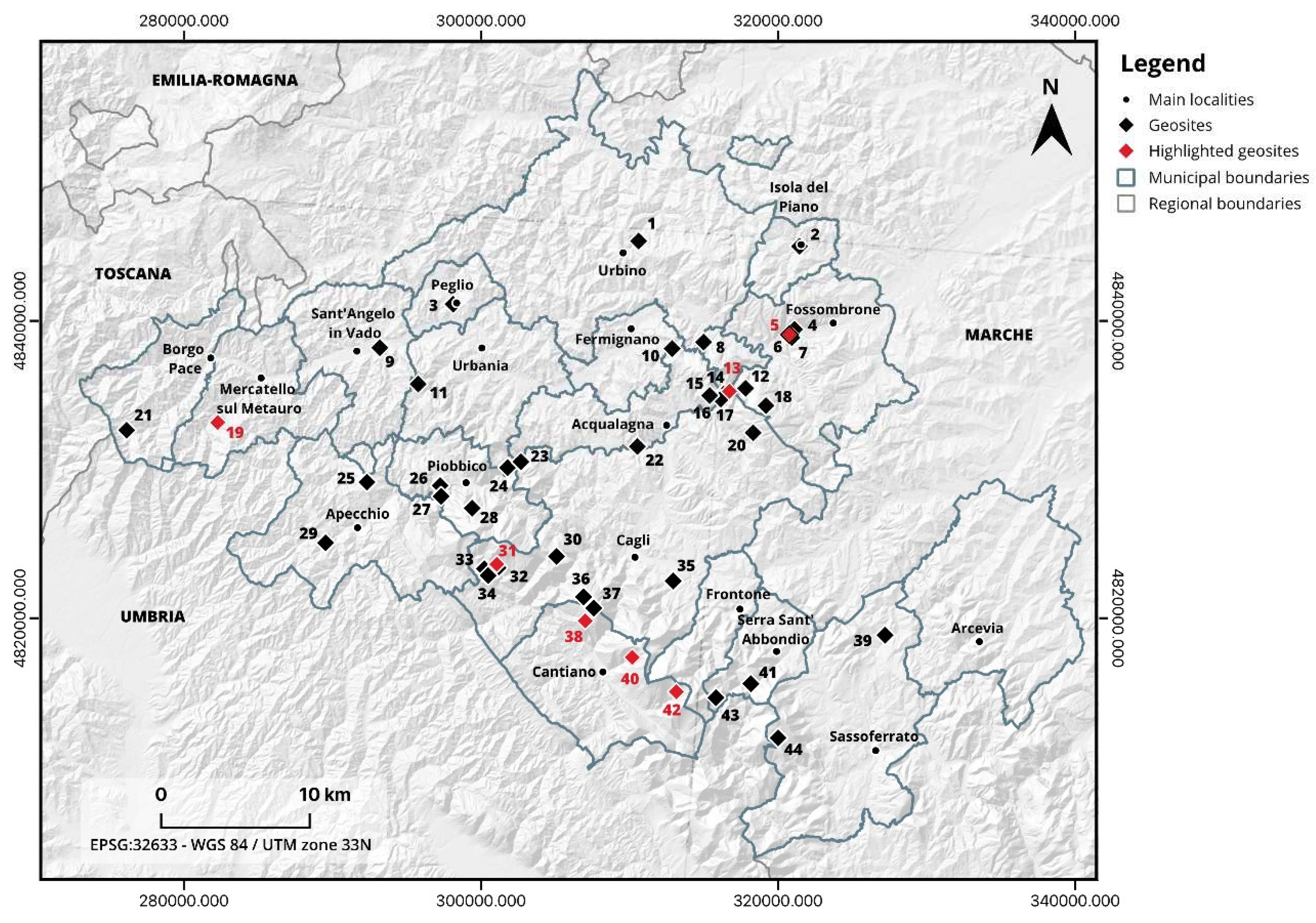
Figure 2.
Simplified geological and structural map of the northern Umbria-Marchean Apennines.
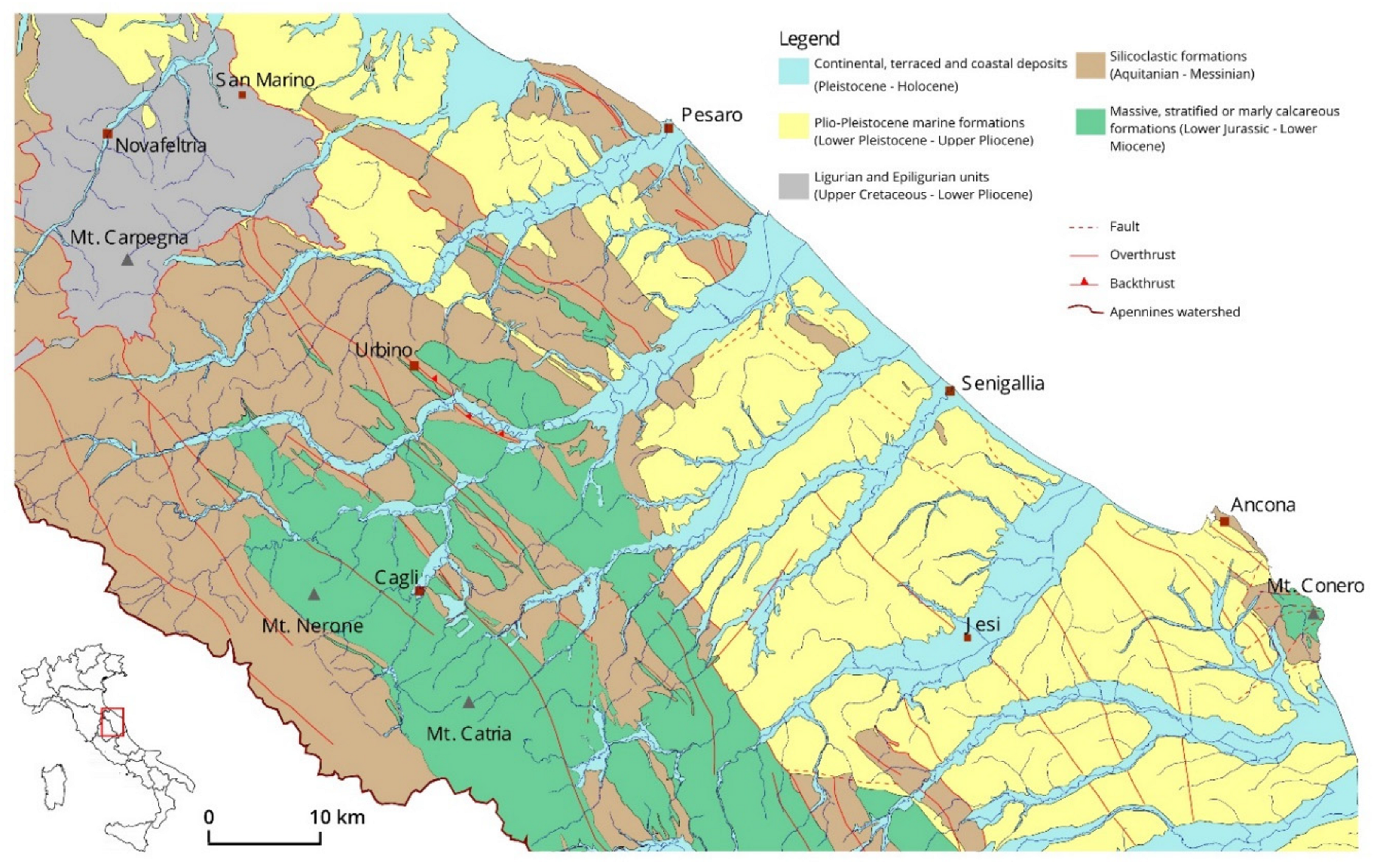
Figure 3.
Perspective view of the Catria-Nerone ridge along an anticline structure (Google Earth Pro).
Figure 3.
Perspective view of the Catria-Nerone ridge along an anticline structure (Google Earth Pro).
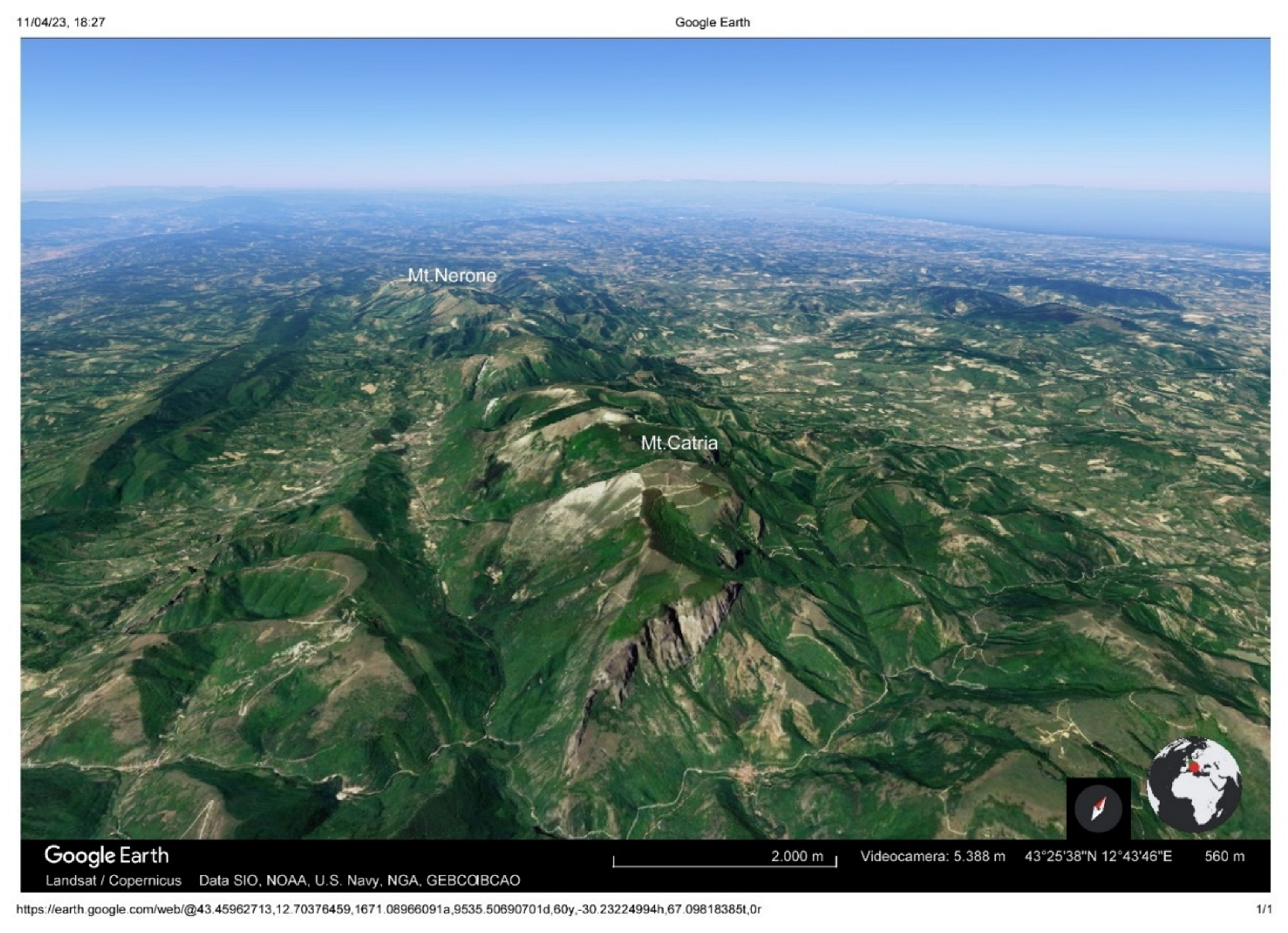
Figure 4.
(a) The San Lazzaro gorge and the Diocleziano bridge; (b) The San Lazzaro gorge and the Giants' Potholes seen from the Diocleziano Bridge; (c), (d) The Palaeo-potholes.
Figure 4.
(a) The San Lazzaro gorge and the Diocleziano bridge; (b) The San Lazzaro gorge and the Giants' Potholes seen from the Diocleziano Bridge; (c), (d) The Palaeo-potholes.
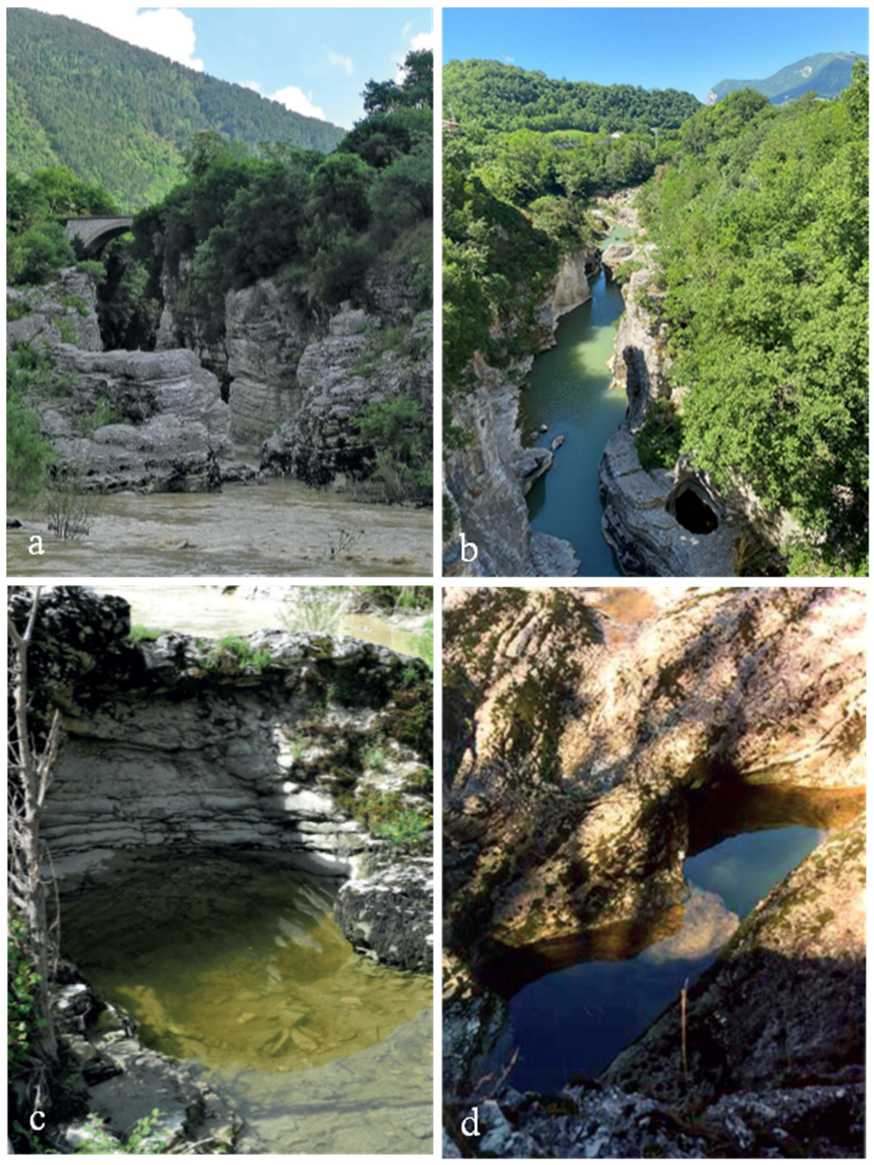
Figure 5.
(a) Overview of the Furlo Mts. and the Furlo Gorge, seen from the SW. On the left is visible the Buzzo Gorge; (b) Vertical walls in the Jurassic Calcare Massiccio Formation; (5) One of the characteristic landforms of the area: pinnacle; 5d. Debris cone in the valley floor, covered by vegetation.
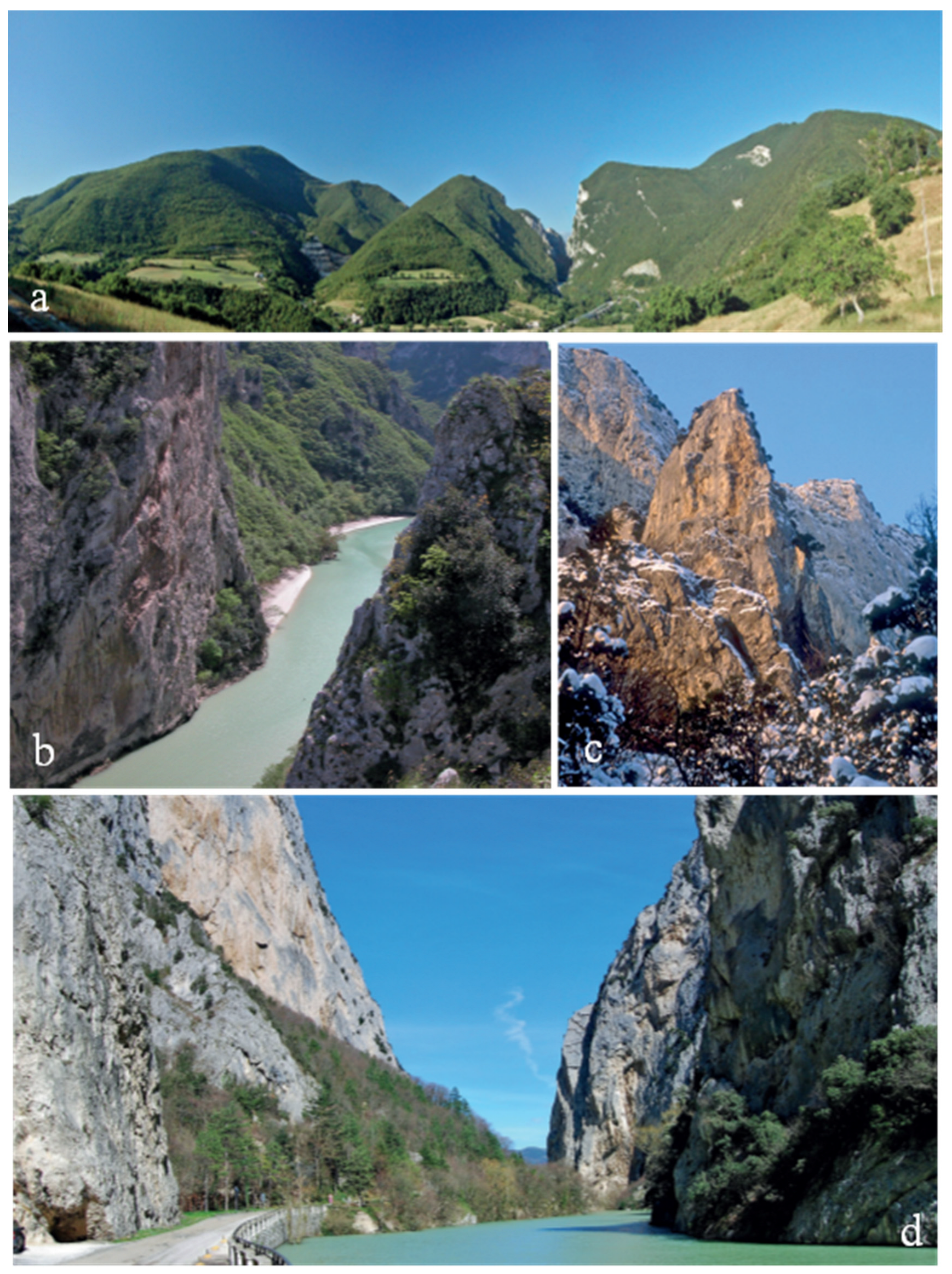
Figure 6.
(a) The slope eroded by aerial washout; (b) The so-called “Piota”; (c) Dome and mamelon shapes on marls; (d), (e), (f). Forms of erosion related to weathering processes.
Figure 6.
(a) The slope eroded by aerial washout; (b) The so-called “Piota”; (c) Dome and mamelon shapes on marls; (d), (e), (f). Forms of erosion related to weathering processes.
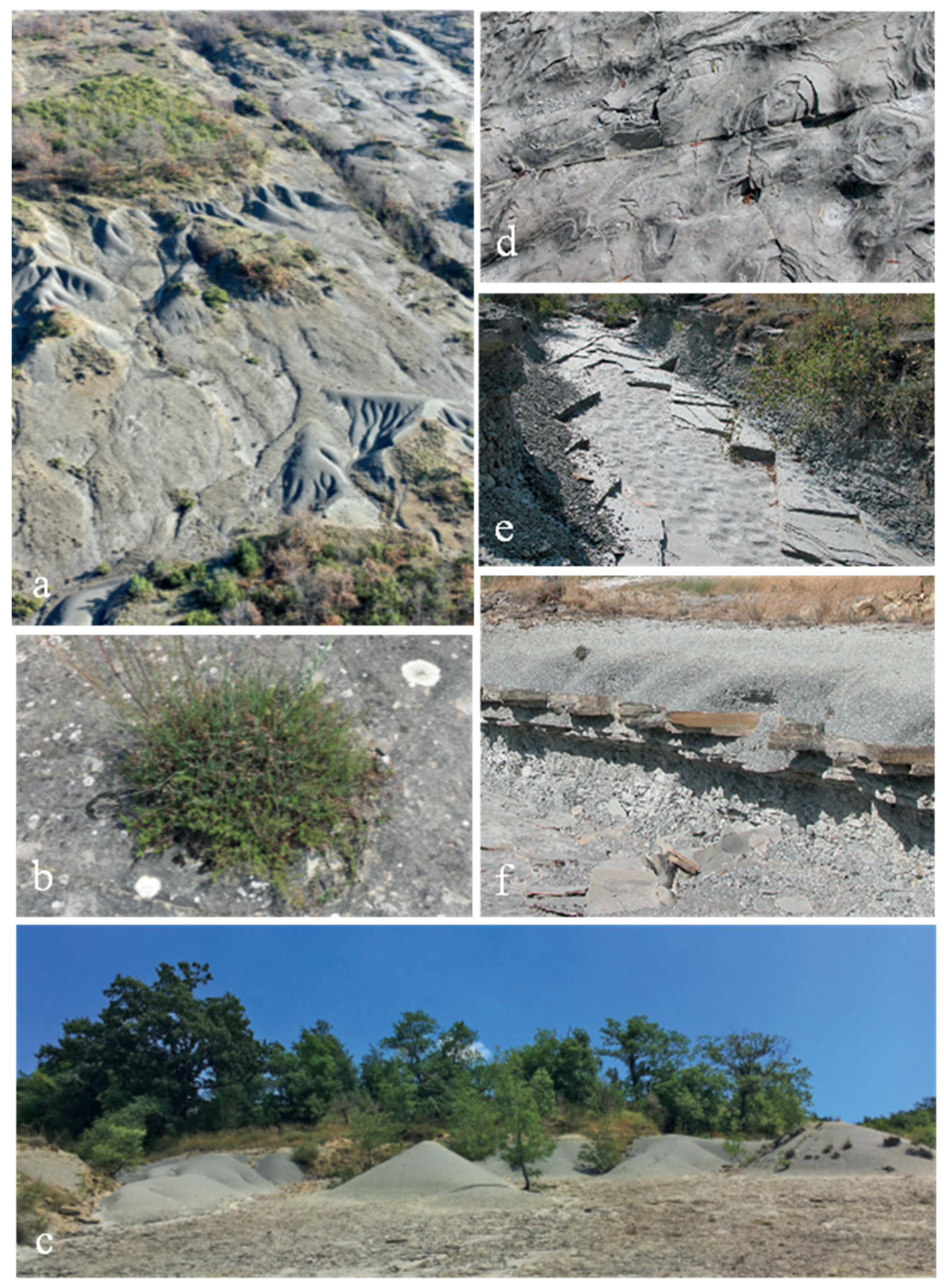
Figure 7.
(a) Overview of the south-western side of Mt. Nerone: the 'City of Rock' of the Giordano River basin; (b) Sasso della Rocca (on the left) and Sasso del Re (on the right). (c) Aerial view of the Fondarca natural arch, representing the remains of a large collapsed cave.
Figure 7.
(a) Overview of the south-western side of Mt. Nerone: the 'City of Rock' of the Giordano River basin; (b) Sasso della Rocca (on the left) and Sasso del Re (on the right). (c) Aerial view of the Fondarca natural arch, representing the remains of a large collapsed cave.
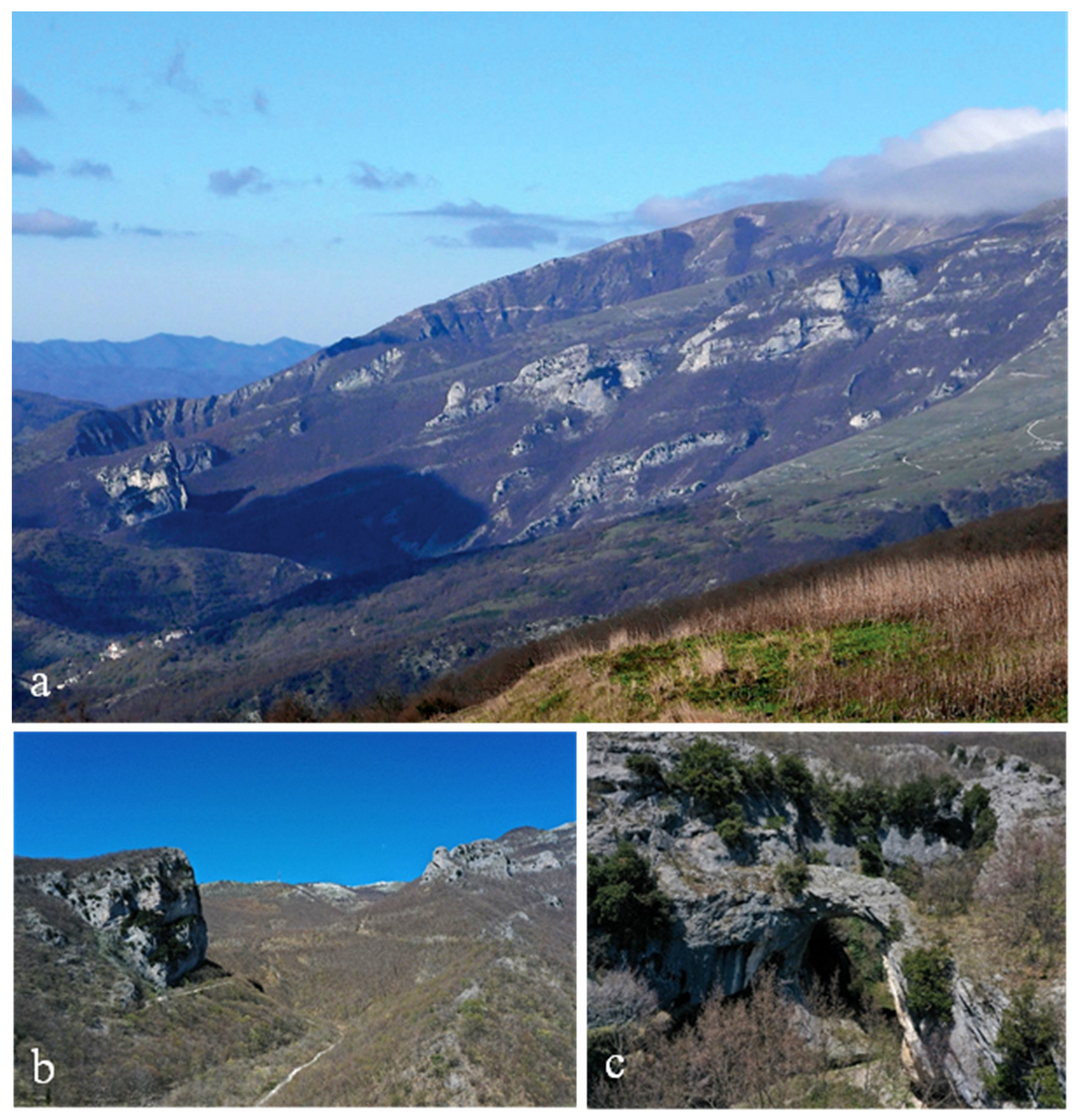
Figure 8.
(a) View of the anticlinal ridge towards Mt. Catria, seen from Mt. Petrano; (b) View of the same anticlinal ridge towards Mt. Nerone, seen from Mt. Petrano; (c) The Roccaccia flatiron on the south-western flank of Mt. Petrano; (d) Panoramic view towards the Adriatic Sea from Mt. Petrano.
Figure 8.
(a) View of the anticlinal ridge towards Mt. Catria, seen from Mt. Petrano; (b) View of the same anticlinal ridge towards Mt. Nerone, seen from Mt. Petrano; (c) The Roccaccia flatiron on the south-western flank of Mt. Petrano; (d) Panoramic view towards the Adriatic Sea from Mt. Petrano.
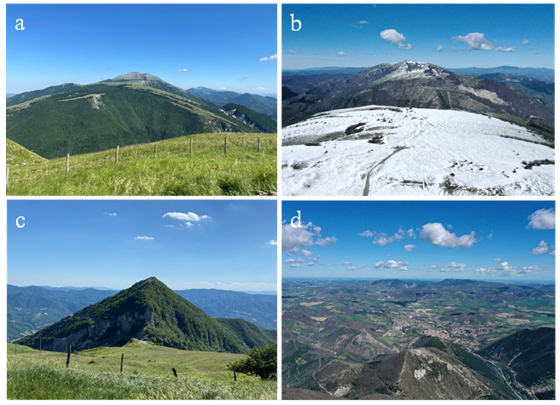
Figure 9.
(a) Overview of the Mt. Tenetra and the Tenetra Stream basin; (b) Vertical view of the Tenetra Stream basin (Google Earth Pro); (c) Topographical mapping of the area (Catasto Pontificio, 1816).
Figure 9.
(a) Overview of the Mt. Tenetra and the Tenetra Stream basin; (b) Vertical view of the Tenetra Stream basin (Google Earth Pro); (c) Topographical mapping of the area (Catasto Pontificio, 1816).
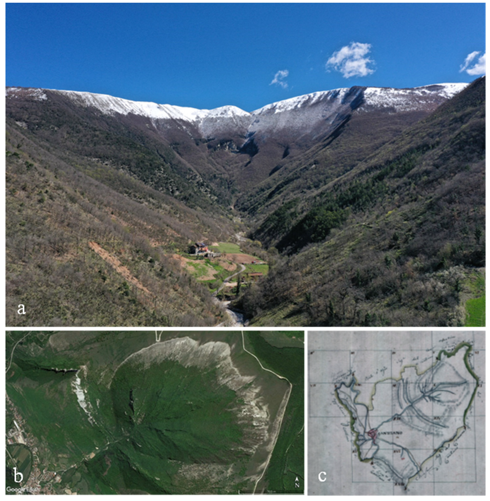
Figure 10.
(a) The Bevano stream basin on the south-western slope of Mt. Catria; (b), (c) The Bevano stream basin: reconstruction of the palaeo-glacier [46].
Figure 10.
(a) The Bevano stream basin on the south-western slope of Mt. Catria; (b), (c) The Bevano stream basin: reconstruction of the palaeo-glacier [46].
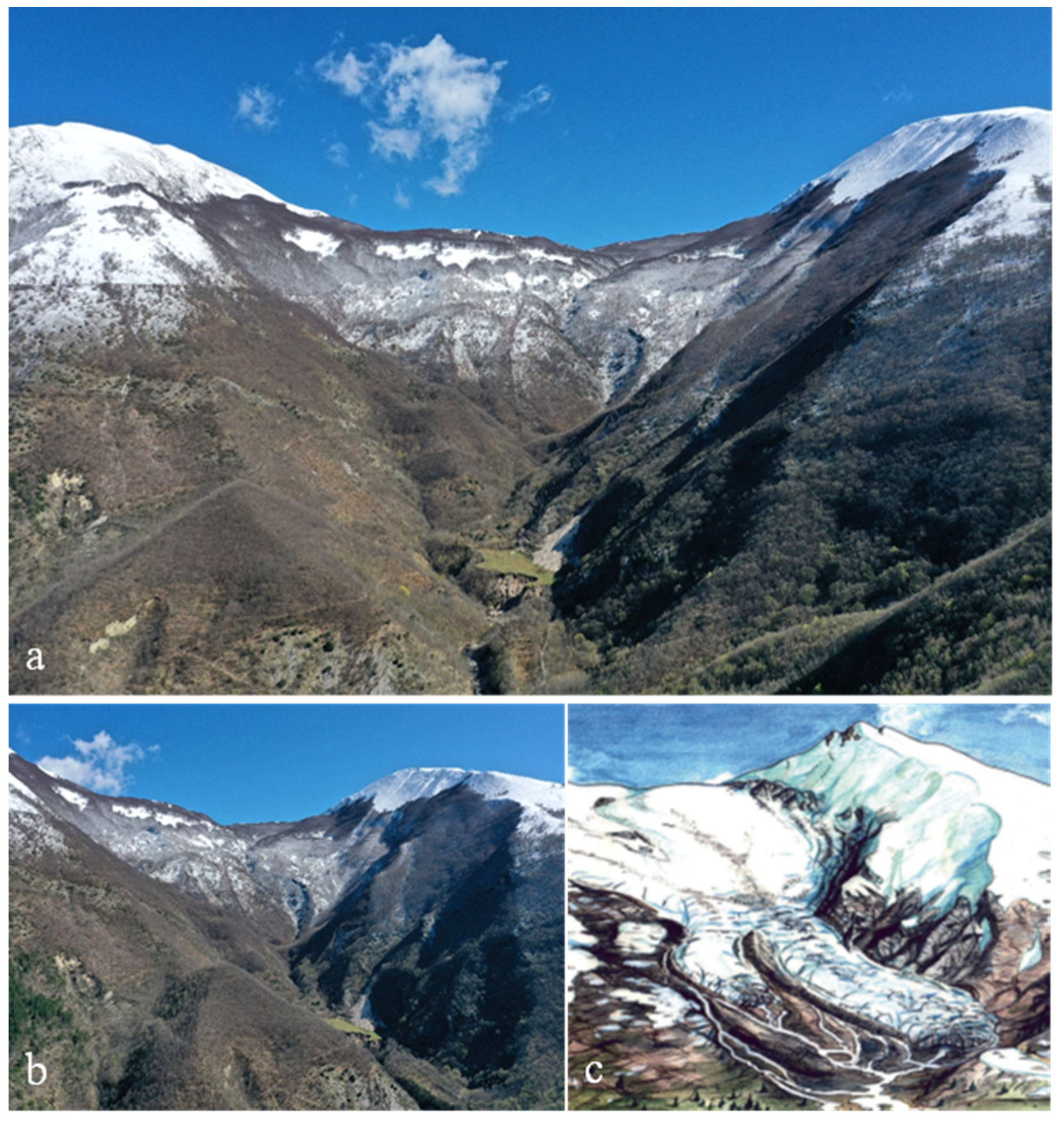

Table 1.
Geosites inventory in the study area. In bold the 7 proposed geosites.
| Nr. | Geosite | Municipality | Province |
|---|---|---|---|
| 1 | Sasso landslide | Urbino | PU |
| 2 | Isola del Piano alluvial fan | Isola del Piano | PU |
| 3 | Peglio Gypsum Formation | Urbania | PU |
| 4 | San Lazzaro historic landslide | Fossombrone | PU |
| 5 | San Lazzaro Giants' Potholes | Fossombrone | PU |
| 6 | San Lazzaro River gorge | Fossombrone | PU |
| 7 | Fossombrone fluvial terraces | Fossombrone | PU |
| 8 | Mt. Pietralata flatirons | Acqualagna | PU |
| 9 | Sasso waterfall | Sant’Angelo in Vado | PU |
| 10 | Mt. Pietralata rill erosion areas | Acqualagna | PU |
| 11 | Mt. Càgnero Rupelian Chattian GSSP | Urbania | PU |
| 12 | Buzzo gorge | Acqualagna | PU |
| 13 | Furlo gorge | Acqualagna | PU |
| 14 | Furlo Grain Cave | Acqualagna | PU |
| 15 | Furlo waterfall | Acqualagna | PU |
| 16 | Furlo Bonarelli Level marker | Acqualagna | PU |
| 17 | Furlo fault walls | Acqualagna | PU |
| 18 | Ca' I Fabbri landslide | Acqualagna | PU |
| 19 | Piote of St. Antony - rill erosion area | Mercatello sul Metauro | PU |
| 20 | La Pradella landslide | Acqualagna | PU |
| 21 | Lago del Sole – Palaeo-landslide | Borgo Pace | PU |
| 22 | Petriccio K-Pg boundary | Acqualagna | PU |
| 23 | Gorgo a Cerbara GSSP Barremian-Aptian (propose) | Urbania – Piobbico | PU |
| 24 | Balza della Penna fault wall | Urbania – Piobbico | PU |
| 25 | Mt. Vicino relief inversion | Apecchio | PU |
| 26 | Biscubio Torrent rill erosion | Piobbico | PU |
| 27 | Rio Vitoschio gorge | Piobbico | PU |
| 28 | Balza forata erosional monument | Piobbico | PU |
| 29 | Apecchio slump | Apecchio | PU |
| 30 | Poggio le Guaine - Cretaceus anoxic events | Cagli | PU |
| 31 | Fondarca natural arch | Cagli | PU |
| 32 | Giordano spring | Cagli | PU |
| 33 | Sasso del Re and Sasso della Rocca karst erosion forms | Cagli | PU |
| 34 | Pieia blind valley | Cagli | PU |
| 35 | Acquaviva alluvial fans | Cagli | PU |
| 36 | Petrano structural plain | Cantiano-Cagli | PU |
| 37 | La Rocchetta structural relict | Cantiano-Cagli | PU |
| 38 | Mt. Petrano – La Roccaccia flatiron | Cantiano-Cagli | PU |
| 39 | Cabernardi Sulfur mine | Sassoferrato | AN |
| 40 | Mt. Tenetra natural amphitheatre | Cantiano-Frontone | PU |
| 41 | Mt. Mura fault wall | Serra Sant’Abbondio | PU |
| 42 | Mt. Catria - Bevano Pleistocene glacier | Cantiano | PU |
| 43 | Mt. Catria fault scarp | Serra Sant’Abbondio | PU |
| 44 | Montelago Holocenic lake | Sassoferrato | AN |
Table 2.
Protected areas in Marche Region. * = surface area within the Marche Region.
| Nr. | Name | Surface area (ha) | Nr. of involved municipalities |
|---|---|---|---|
| 1 | National Park Mts. Sibillini | 51.473,98* | 16 |
| 2 | National Park Gran Sasso and Monti della Laga | 9.363,22* | 2 |
| 3 | Natural Regional Park Mt. Conero | 5.982,74 | 4 |
| 4 | Natural Regional Park Mt. San Bartolo | 1.584,04 | 2 |
| 5 | Natural Interregional Park Sasso Simone and Simoncello | 2.639,45* | 4 |
| 6 | Natural Regional Park Gola della Rossa and Frasassi | 10.026,53 | 5 |
| 7 | State Natural Reserve Mt. Torricchio | 310,91 | 2 |
| 8 | State Natural Reserve Abbadia di Fiastra | 1.834,28 | 2 |
| 9 | State Natural Reserve Furlo Gorge | 3.626,94 | 5 |
| 10 | State Natural Reserve Ripa Bianca | 310,86 | 1 |
| 11 | State Natural Reserve Sentina | 174,34 | 1 |
| 12 | State Natural Reserve Mt. San Vicino and Mt. Confaito | 1.946,69 | 4 |
| 13 | State Natural Reserve Bosco delle Tecchie | 196,74 | 1 |
Disclaimer/Publisher’s Note: The statements, opinions and data contained in all publications are solely those of the individual author(s) and contributor(s) and not of MDPI and/or the editor(s). MDPI and/or the editor(s) disclaim responsibility for any injury to people or property resulting from any ideas, methods, instructions or products referred to in the content. |
© 2023 by the authors. Licensee MDPI, Basel, Switzerland. This article is an open access article distributed under the terms and conditions of the Creative Commons Attribution (CC BY) license (http://creativecommons.org/licenses/by/4.0/).
Copyright: This open access article is published under a Creative Commons CC BY 4.0 license, which permit the free download, distribution, and reuse, provided that the author and preprint are cited in any reuse.


