Submitted:
21 April 2023
Posted:
23 April 2023
You are already at the latest version
Abstract
Due to the impacts from climate change, the allocation of water resources must urgently be optimized worldwide to ensure that the needs of both water managers and farmers are balanced. In this study, manager-oriented and farmer-oriented assessment models were developed for irrigation water optimization and allocation. The distance from water sources and hydraulic head were the main factors in the manager-oriented assessment model; crop value, water demand of crops, and soil type were additional factors in the farmer-oriented assessment model. The developed assessment models were used to assess irrigation water allocation in five villages in Neimen District. Cadasters at high elevation were discovered to not be suitable for cultivation of crops because of the difficulties in constructing irrigation facilities and the loss of irrigation water during transportation. The result obtained from the manager-oriented assessment system was related to the costs involved in the construction and maintenance of irrigation facilities, which indicated that cadasters located at long distances from water sources and at high elevation are unsuitable for cultivation. By contrast, the result obtained from the farmer-oriented assessment system was related to the profits of farmers and revealed that more cadasters would be suitable for cultivation if suitable crops were chosen.
Keywords:
Irrigation water management
; Agriculture
; Remote sensing
; Optimization
1. Introduction
Climate change and a growing population have led to severe water scarcity worldwide, which is a major global concern. Taiwan is surrounded by sea and has a warm and humid climate. Although Taiwan has abundant rainfall, equal to approximately 2.5 times the average annual rainfall throughout the world, Taiwan’s water resources are unevenly distributed, and with the average amount of water available per person in Taiwan being relatively low compared with that in many other countries. Therefore, despite the abundant rainfall in Taiwan, the country actually faces water shortages [1,2]. Optimizing the allocation of water resources has become a major concern in Taiwan, particularly in the country’s agriculture sector. Taiwan has 17 irrigation associations that are responsible for managing water resources and maintaining irrigation facilities across the country. In 2019, the Kaohsiung Irrigation Association planned to extend areas of irrigation to Neimen District. However, the lack of an assessment system for optimizing the irrigation water resources led to challenges in achieving the irrigation area extension. Therefore, this study developed an assessment system for optimizing irrigation water resources; the system may assist the Kaohsiung Irrigation Association in assessing the order of irrigation area extension.
The locations of water resources are crucial to the development of assessment systems for optimizing irrigation water resources because the distances between the water sources and irrigation areas directly affect the cost of irrigation. Thus, identification of water bodies is necessary. Satellite imagery is widely used for detection of large water bodies, and various satellites have been employed to acquire water body data, including Sentinel-2, ALOS/AVNIR-2, and Terra/ASTER [3,4]. Remote sensing, including satellite imagery, can provide information on water bodies in a timely manner and with complete coverage. Algorithms such as threshold method and machine-learning algorithms can be employed to obtain useful information from remote-sensing data [5]. Many methods have been combined with satellite imagery for extraction of information on water bodies, including the support vector machine (SVM), decision tree, and artificial neural network (ANN) [6,7,8]. Thus, satellite imagery is considered a suitable approach for observing water bodies on large scales; moreover, many methods can be applied to extract information on water bodies from satellite imagery data. The Geographic Information System (GIS) is another powerful approach to water resource management and can help with the storage, management, and display of information on water resources [9]. The GIS has been widely applied in studies on water resource management, including in modeling and decision-making related to irrigation water resources [10,11]. In addition, many studies on water resource management have combined the GIS with remote-sensing techniques. Land use and land cover (LULC) information can be generated by obtaining land surface information—such as soil, vegetation cover, and watershed areas—through remote-sensing technology. This information can be processed and analyzed through the GIS and be used in the management and development of water resources [12,13]. The use of remote sensing and the GIS has been shown to be feasible and efficient for water resource management.
Although the use of remote sensing and the GIS has greatly improved the efficiency of water resource management, some improvements are still needed. Many approaches to allocating water reasonably and efficiently have been developed [14,15]. Most scholars have focused on enabling water managers to optimize water resource allocation but have neglected the needs of farmers. Thus, this study developed an assessment system for irrigation water allocation in which the allocation of water resources is optimized by considering the concerns of both managers and farmers. We utilized satellite imagery together with the GIS to observe water bodies, extract information related to water bodies, and analyze the geospatial information.
2. Materials and Methods
2.1. Research area
To fulfill Kaohsiung Irrigation Association’s objective—to extend irrigation areas to Neimen District—five villages in Neimen District were selected as the research areas, namely Jinzhu, Gouping, Yongxing, Yongji, and Yongfu villages. The research area is shown in Figure 1. Neimen District is a rural district of Kaohsiung in southern Taiwan and comprises a total of 18 villages. Neimen District is characterized by high and low elevations in the north and south and is located between a flat area and hillside, with the overall elevation mostly exceeding 100 m. The research area is located in the Gouping basin of Neimen District, which has a large catchment area and stable base flow. The total area of the study site is approximately 3,202 hectares. Statistical information obtained from the Taiwanese government indicates that the five villages mostly comprise agricultural and forestry land except for Yongxing village, which has more areas with other land uses including building land. Moreover, Neimen District has a considerable agricultural industry, particularly for the cultivation of longan, pineapple, and litchi. Given the importance of the agricultural industry in Neimen District, optimization of irrigation water resources is necessary in this area. Thus, the aforementioned five villages in Neimen District with relatively rich water resources were selected as the study site.
2.2. Satellite imageries
With the importance of water resources, water bodies observation and extraction are required in this study. To observe the water bodies distribution within research area, satellite images from SPOT6 were collected, which were from January, 2017 to November, 2018. SPOT6 satellite was launched in 2012 and the SPOT6 images used in this study were collected from the Center for Space and Remote Sensing Research, NCU (CSRSR) in Taiwan. SPOT6 imagery provides land surface images with high resolution which offers panchromatic imaging and multispectral imaging with spatial resolution of 1.5 m and 6 m. Due to the high spatial resolution of SPOT6 imagery, land surface features can be depicted well and comprehensively (Kganyago et al., 2018; Forsyth et al., 2014). In this study, 4 satellite images were collected which were from 30th January, 2017, 17th November, 2017, 16th January, 2018 and 3rd November, 2018. According to the special reflectance of water bodies in Near Infrared (NIR) band of SPOT6 images, the NIR band of images were suitable for classification of water and non-water (Mondejar and Tongco, 2019), and they were applied in this study to extract the information of water bodies.
Apart from SPOT6 imageries, Digital Elevation Model (DEM) of research areas was also collected to observe and locate the rivers, tributaries and streams within research area. DEM was widly applied in studies of river extraction and achieved fine performance (Gichamo et al., 2012; Gui et al., 2022). Thus, the DEM provided by the Department of Land Administration, M.O.I. in Taiwan, which has high spatial resolution of 20 m, was collected and applied in the follow-up analysis. The efforts of river extraction in this study were conducted with the software ArcGIS which is a powerful tool in hydrology analysis.
2.3. Geographic Information System (GIS)
GIS is a great approach for spatial information analyzing and processing which combined Digital map, Database and Function of Spatial analyses and operation (Tomlinson, 1989). In this study, ArcGIS was decided to use because it is a powerful and popular approach in geographic information management. With 3 main tools in ArcGIS: ArcMap, ArcCatalog and ArcToolbox, ArcGIS became a great approach in plotting, editing, format conversion, information analyzing and managing. In previous studies of irrigation water management, GIS has been widely applied. With GIS’s help, irrigation water was well managed and the irrigation water allocation was also optimized, which greatly helped the agricultural industry (Kamal and Amin, 2010; Mohammadi, 2019; Yousaf et al., 2021). Takes the successful examples and benefits of GIS, GIS was used in this study to help water bodies extraction, spatial information analyzing and displaying.
In this study, GIS was applied in the extraction of rivers, tributaries and streams within research area first. Within the packages of Extraction and Hydrology in spatial analyst toolbox, there are some functions used in this study to extract the water bodies from DEM including Fill, Flow Direction and Flow Accumulation. Therefore, rivers, tributaries and streams were well classified and used in the subsequent analysis. Then, buffer analysis of different kinds of water body were conducted. Three kinds of buffer were set to determine the distance between water bodies and villages which were 100 m, 200 m and 300 m. Distance between water bodies and villages is necessary in this study which affects the cost of irrigation water management facilities directly. Apart from the spatial information processing, GIS was also used to display the results in this study including maps of water bodies, analyzing result and order of villages ranked by the assessment system built in this study.
2.4. Assessment system
Through satellite imagery data collection and GIS data processing, based on the viewpoints of managers and farmers, an evaluation system for irrigation water resource optimization in 5 villages in Neimen District was developed. In order to understand the weight of each factor in irrigation water optimization in manger points of view, the opinions of 5 senior managers of Kaohsiung Irrigation Association were referred. The senior management then mentioned 2 main factors, distance from water sources and hydraulic head, which are weighted equally at 50%. For the factor of distance to water sources, different scores are determined according to different types of water sources. If the agricultural cadaster has the nearest river or pond water source, the land will receive 10 to 50 scores based on the distance to the water source; if the Agricultural cadaster has the nearest tributary water source, the land will receive 8 to 40 scores based on the distance to the water source ; if the Agricultural cadaster has the nearest stream water source, the land will have between 6 and 30 scores depending on the distance from the water source. Moreover, hydraulic head is another factor that senior executives concerned the most which weighted 50%. Based on the hydraulic head from Agricultural cadaster to water sources, different scores were assigned. If the Agricultural cadaster has less than 1 m hydraulic head from water sources, the land will have 50 scores which is the maximum; if the Agricultural cadaster has more than 60 m hydraulic head from water sources, the land will have 10 score which is the lowest. The detail of manager-oriented assessment for irrigation water optimization has been showed at Table 1.
On the other hand, farmer-oriented assessment for irrigation water optimization was also developed. In farmer points of view, factors and weights must be different from the managers. Thus, more factors were considered in this assessment and weights of each factor were changed. Apart from distance to water sources and hydraulic head, three factors were added into the assessment including price of crops, water demand and soil type. In farmer-oriented assessment, factors of distance to water sources and hydraulic head weighted 25 % respectively. Then, the factors of crops prices, water demand and soil type weighted 15%, 15% and 20% in the farmer-oriented assessment, respectively. For the factor of crops prices, the scores will be calculated based on the type of crop, which can gain higher score with higher price; Furthermore, the score of water demand will be calculated based on the type of crop, which gain higher score with less water demand; Finally, the score of soil type will be calculated based on the retention capacity of soil, which gain higher score with better retention capacity. The assessment system in detail including weights, description and calculation was showed at Table 2.
3. Results
3.1. Water sources analysis
To identify the distribution of water resources, SPOT6 imageries and DEM were collected. In addition to the hydrological processing by GIS, ANN was also applied in this study to extract water ponds from SPOT6 imageries. With well-training, the ANN model was able to classify water ponds from SPOT6 imageries and the water ponds classification has shown at Figure 2. Rivers, tributaries and streams generated by DEM and GIS were also presented at Figure 3. In addition to the river network, there are many ponds that were detected, classified and located, which showed at Figure 3. Apart from the natural ponds, some ponds were built by nearby farmers themselves due to long-term insufficient water for irrigation. River network including the main channel, tributaries and streams was located in the central of research area and the ponds were distributed and scattered surrounding the river network. Higher cost of building irrigation facilities come from the longer distance to water sources. Thus, buffer analysis of water sources was conducted with GIS to investigate the distance from agricultural cadasters to water sources. Two kinds of buffer were determined for ponds and river network respectively, which showed at Figure 2.
3.2. Manager-oriented water resources allocation
Agricultural cadasters within the study area were scored based on water source information and buffer analysis. According to the manager-oriented assessment of water resource allocation, water head is another important factor that directly affects the cost of irrigation facilities. Therefore, Agricultural cadasters within the study area were also scored based on the difference in assessment from Agricultural cadasters to water sources. The elevation difference of Neimen District is obvious, and some areas are close to the water source, but the height difference with the water source is relatively large, resulting the cost of irrigation facilities is high, and the construction is difficult. However, the hydraulic heads for each Agricultural cadaster were calculated and used for subsequent assessments. After assessing the distance to the water source and head, the results were generated and has shown in Figure 3. From Figure 3, the scores for each Agricultural cadaster were calculated and 3 legends are shown: red indicates areas with relatively low scores meaning that the cost of building irrigation facilities in these areas is high; areas with relatively high scores are in green , which means that it is easier to set up irrigation facilities in these areas, and these areas should be given priority; yellow indicates the areas that should be considered after completing the green area irrigation allocation work. In addition, the assessment results also showed that most of the red areas appear in areas with higher altitudes, and the construction of irrigation facilities is difficult and costly. In addition, most of the green land appears around the river network, which is close to the water source and convenient for irrigation. Overall, the result showed the importance of elevation in irrigation of agriculture industry of Neimen District, which directly affected the cost of irrigation facilities and irrigation order of different cadasters.
3.3. Farmers-oriented water resources allocation
To assess the irrigation water allocation and optimization in farmer’s point of view, researches of crops and food market were needed. Thus, the information of crops in Neimen District was collected and analyzed. In addition, head-based irrigation water tariff information was also collected and analyzed. Higher hydraulic head, higher irrigation water fee, which caused higher cost of cropping. Hence, information of crops cost, water demand of different crops, irrigation water fee, soil retention capacity and wholesale prices of different crops in recent years were collected and analyzed in the follow-up analysis. Then, different hydraulic head situation for different crops were analyzed to investigate the changes of cost and profit priorities after cadasters managed by the irrigation association of Kaohsiung. The result has shown at Table 3. From Table 3, the differences of cost and profit priorities in different situation of hydraulic head were presented. The costs of each crop increased with the increasing hydraulic head. Although the hydraulic head affect the costs and profit priorities of crops obviously, the cost and profit priorities didn’t change greatly. The result can be referred by farmers and managers to optimize the cropping distribution within 5 villages in Neimen District. The result of cost and profit priorities in Table 3 was also applied in the further assessment of irrigation water optimization and allocation. With the information of crops values, water demand of different crops and soil retention capacity of different cadasters, the farmer-oriented assessment was conducted and the result was generated and presented at Figure 4. The result was similar to the result of manager-oriented assessment but with slightly differences. The result was also presented with 3 legends like Figure 3, and the red indicates areas with relatively low scores which means the cadasters are far from water sources and not recommended to do any cropping. Green indicates areas with relatively high scores which means the cadasters are close to water sources and have better soil retention capacity. Also, the crops within these cadasters need less water and have high profit. Thus, these cadasters were recommended to continue the current cropping efforts. Finally, yellow indicates areas with not low scores which means these cadasters are little bit far from water sources and have relative high elevation. Thus, crops with lower water demand were suggested to plant in these cadasters. In addition, the cadasters with relatively low scores were also appeared in the areas with high elevation, which similar to the result from manager-oriented assessment. But some cadasters surrounding the river network were indicated with yellow color unlike the result from manager-oriented assessment, which means these cadasters should consider other types of crops to optimize the water resources and increase the cropping profit.
4. Discussion
4.1. Implementation of irrigation association of Kaohsiung
Both farmer- and manager-oriented assessment for irrigation water allocation and optimization of 5 villages in Neimen District were conducted and the results were generated. Both assessments generated similar results but slightly different, which is acceptable because of different points of view from farmers and managers. Although both assessments were conducted which generated different results which helped to balance the interests of managers and farmers, the irrigation association of Kaohsiung finally took the result of manager-oriented assessment as reference to optimize and allocate irrigation water for the 5 villages in Neimen District. Based on the policy of irrigation association of Kaohsiung, cadasters with irrigation areas ranged from 51 to 150 hectares should be managed as a hydrological group. Thus, 12 groups were assigned based on the assessment results, policy, catchment areas and terrain, which presented at Figure 5. From Figure 5, most of the cadasters with relative low scores were omitted, which ensured the water resources were optimized. The 5 villages in Neimen District have a total area of 3202.32 hectares, including 1860.62 hectares of agricultural land. After the manager-oriented assessment, 1,164.40 hectares of agricultural land was recommended to allocate irrigation water resources and finally 903.75 hectares of agricultural land were assigned to 12 groups, which allocated and optimized irrigation water resources by the irrigation association of Kaohsiung. Most Cadasters in Gouping village were omitted in the final irrigation decision even they scored fine in farmer-oriented assessment. But in the manager points of view, cadasters in Gouping village were far from water sources and have relative high elevation, which are hard to get water and not recommended to crop. Overall, the final irrigation decision by the irrigation association of Kaohsiung helped most of the agricultural land of 5 villages in Neimen District to allocate irrigation water, which optimized and reduced the use and waster of irrigation water.
4.2. Limitation and suggestion
According to the result above, the assessments provided in this study helped the allocation and optimization of irrigation water for 5 villages in Neimen District. They balanced the interests of managers and farmers, which helped managers to manage and build irrigation facilities, and helped farmers to evaluate appropriate crops to obtain more profits. Although the assessments helped in irrigation water allocation and optimization, some issues and problem should be discussed and solved in further efforts. In the assessments, weights of each factor were referred to the opinions of experts and managers with experiences, which may be different because of interviewing different experts and managers. To improve the weights of assessments system, more methods or algorithms can be tried and applied, such as Analytic Hierarchy Process (AHP) and Technique for Order Preference by Similarity to Ideal Solution (TOPSIS), which were widely applied in weighting efforts (Wang and Lee, 2009; Ho, 2008). In addition, machine learning methods were also popular in weighting efforts, which can be applied in further works (Ramezani et al., 2014; Hall, 2007). In addition, more information in detail should be investigated and considered in the further works, including investigating the relationship between crops and soil types to allocate irrigation water more reasonable and estimating the water supplies of water bodies to optimize the irrigation water based on the soil characteristics of each cadaster to maximize the irrigation area. Moreover, both concerns of managers and farmers should be considered to balance the interests and rights of them. Even the manager-oriented assessment provided information of irrigation water allocation and optimization for managers in their points of view, which controlled and reduced the cost of irrigation facilities and optimized the irrigation water allocation. Famers’ interests were also important which helped irrigation water allocation and optimization by deciding the suitable crops for each cadaster. Therefore, results of both assessments were suggested to be considered in the further works.
5. Conclusions
In this study, assessments for irrigation water allocation and optimization were provided which were farmer- and manager-oriented. In manager-oriented assessment, distance to water sources and hydraulic head were the main concerns which helped to reduce the cost of irrigation facilities and loss of water transportation; In famer-oriented assessment, three more factors were considered apart from factors above which were values of crops, water demands of crops and soil types. Considering these factors can help to optimize the irrigation water allocation in farmer points of view, which optimized and reduced the use and waste of irrigation water. Also, farmers can decide to grow the suitable crops to gain more profit during saving irrigation water resources. However, the irrigation association of Kaohsiung took the result from manager-oriented assessment as reference to allocate and manage the irrigation water for 5 villages in Neimen District, and 12 groups were assigned based on the assessment results, policy, catchment areas and terrain, which helped to optimize the irrigation water for 5 villages in Neimen District. Although the irrigation association of Kaohsiung took the results from this study as reference and managed irrigation water resources in research area fine, result from farmer-oriented assessment was still important in balancing the interests of farmer and optimizing irrigation water allocation. Thus, opinions of farmers and mangers were suggested to be referred in the future, which can help to allocate irrigation water more reasonable and suitable.
Author Contributions
Conceptualization, K.-H.H.; Methodology, W.-T.H..; Formal analysis, W.-T.H.; Supervision, K.-H.H.; writing—original draft preparation, W.-T.H.; writing—review and editing, T.-K.L.; visualization, T.-K.L. All authors have read and agreed to the published version of the manuscript.
Funding
This research received no external funding.
Institutional Review Board Statement
Not applicable.
Informed Consent Statement
Informed consent was obtained from all subjects involved in the study.
Conflicts of Interest
The authors declare no conflict of interest.
References
- Cheng, C. L., & Liao, W. J. (2011, December). Current situation and sustainability of water resource in Taiwan. In Proceedings of 1st Asian Water Saving Council Conference (Vol. 141148).
- Hwang, J.-S. The development and management policy of water resources in Taiwan. Paddy Water Environ. 2003, 1, 115–120. [Google Scholar] [CrossRef]
- Kaplan, G.; Avdan, U. Object-based water body extraction model using Sentinel-2 satellite imagery. Eur. J. Remote Sens. 2017, 50, 137–143. [Google Scholar] [CrossRef]
- Zhou, Y. N., Luo, J., Shen, Z., Hu, X., & Yang, H. (2014). Multiscale water body extraction in urban environments from satellite images. IEEE Journal of selected topics in applied earth observations and remote sensing, 7(10), 4301-4312.
- Li, J.; Ma, R.; Cao, Z.; Xue, K.; Xiong, J.; Hu, M.; Feng, X. Satellite Detection of Surface Water Extent: A Review of Methodology. Water 2022, 14, 1148. [Google Scholar] [CrossRef]
- Sarp, G.; Ozcelik, M. Water body extraction and change detection using time series: A case study of Lake Burdur, Turkey. J. Taibah Univ. Sci. 2017, 11, 381–391. [Google Scholar] [CrossRef]
- Rithin Paul Reddy, K., Srija, S. S., Karthi, R., Geetha, P. (2020). Evaluation of water body extraction from satellite images using open-source tools. In Intelligent Systems, Technologies and Applications: Proceedings of ISTA 2018 (pp. 129-140). Springer Singapore.
- Rishikeshan, C.A.; Ramesh, H. An ANN supported mathematical morphology based algorithm for lakes extraction from satellite images. ISH J. Hydraul. Eng. 2018, 24, 222–229. [Google Scholar] [CrossRef]
- Tsihrintzis, V.A.; Hamid, R.; Fuentes, H.R. Use of Geographic Information Systems (GIS) in water resources: A review. Water Resour. Manag. 1996, 10, 251–277. [Google Scholar] [CrossRef]
- Knox, J.; Weatherfield, E. The Application of GIS to Irrigation Water Resource Management in England and Wales. Geogr. J. 1999, 165, 90. [Google Scholar] [CrossRef]
- Ochola, W. O. , & Kerkides, P. (2003). A spatial decision support system for water resources hazard assessment: Local level water resources management with GIS in Kenya. Journal of Geographic Information and Decision Analysis, 7(1), 32-46.
- Singh, P.; Gupta, A.; Singh, M. Hydrological inferences from watershed analysis for water resource management using remote sensing and GIS techniques. Egypt. J. Remote. Sens. Space Sci. 2014, 17, 111–121. [Google Scholar] [CrossRef]
- Chowdary, V.M.; Ramakrishnan, D.; Srivastava, Y.K.; Chandran, V.; Jeyaram, A. Integrated Water Resource Development Plan for Sustainable Management of Mayurakshi Watershed, India using Remote Sensing and GIS. Water Resour. Manag. 2009, 23, 1581–1602. [Google Scholar] [CrossRef]
- Zhang, F.; Guo, S.; Zhang, C.; Guo, P. An interval multiobjective approach considering irrigation canal system conditions for managing irrigation water. J. Clean. Prod. 2019, 211, 293–302. [Google Scholar] [CrossRef]
- Maina, M.; Amin, M.; Yazid, M. Web geographic information system decision support system for irrigation water management: a review. Acta Agric. Scand. Sect. B — Soil Plant Sci. 2014, 64, 283–293. [Google Scholar] [CrossRef]
- Kganyago, M.; Odindi, J.; Adjorlolo, C.; Mhangara, P. Evaluating the capability of Landsat 8 OLI and SPOT 6 for discriminating invasive alien species in the African Savanna landscape. Int. J. Appl. Earth Obs. Geoinformation 2018, 67, 10–19. [Google Scholar] [CrossRef]
- Forsyth, A. T., Gibson, L. A., & Turner, A. A. (2014). Assessment of SPOT 6 imagery for mapping the invasive alien plant species Pinus spp. in a mountainous area of the Western Cape. In Proceedings of the Second AfricaGEO Conference (pp. 1-12).
- Mondejar, J.P.; Tongco, A.F. Near infrared band of Landsat 8 as water index: a case study around Cordova and Lapu-Lapu City, Cebu, Philippines. Sustain. Environ. Res. 2019, 29, 16. [Google Scholar] [CrossRef]
- Gichamo, T.; Popescu, I.; Jonoski, A.; Solomatine, D. River cross-section extraction from the ASTER global DEM for flood modeling. Environ. Model. Softw. 2012, 31, 37–46. [Google Scholar] [CrossRef]
- Gui, R.; Song, W.; Pu, X.; Lu, Y.; Liu, C.; Chen, L. A River Channel Extraction Method Based on a Digital Elevation Model Retrieved from Satellite Imagery. Water 2022, 14, 2387. [Google Scholar] [CrossRef]
- Tomlinson, R. F. (1989). Presidential address: Geographic information systems and geographers in the 1990s. Canadian Geographer/Le Géographe Canadien, 33(4), 290-298. [CrossRef]
- Kamal, R. M. , & Amin, M. S. M. (2010). GIS-based irrigation water management for precision farming of rice. International Journal of Agricultural and Biological Engineering, 3(3), 27-35.
- Mohammadi, N. K. (2019). A Review on GIS in Irrigation and Water Management. vol, 8, 854-857.
- Yousaf, W.; Awan, W.K.; Kamran, M.; Ahmad, S.R.; Bodla, H.U.; Riaz, M.; Umar, M.; Chohan, K. A paradigm of GIS and remote sensing for crop water deficit assessment in near real time to improve irrigation distribution plan. Agric. Water Manag. 2021, 243, 106443. [Google Scholar] [CrossRef]
- Lin, H.-F.; Lee, H.-S.; Wang, D.W. Evaluation of factors influencing knowledge sharing based on a fuzzy AHP approach. J. Inf. Sci. 2009, 35, 25–44. [Google Scholar] [CrossRef]
- Ho, W. Integrated analytic hierarchy process and its applications – A literature review. Eur. J. Oper. Res. 2008, 186, 211–228. [Google Scholar] [CrossRef]
- Ramezani, F. , Nikoo, M., & Nikoo, M. (2015). Artificial neural network weights optimization based on social-based algorithm to realize sediment over the river. Soft Computing, 19, 375-387.
- Hall, M. (2007). A decision tree-based attribute weighting filter for naive Bayes. In Research and Development in Intelligent Systems XXIII: Proceedings of AI-2006, the Twenty-sixth SGAI International Conference on Innovative Techniques and Applications of Artificial Intelligence (pp. 59-70). Springer London.
Figure 1.
Research area: 5 villages in Neimen District.
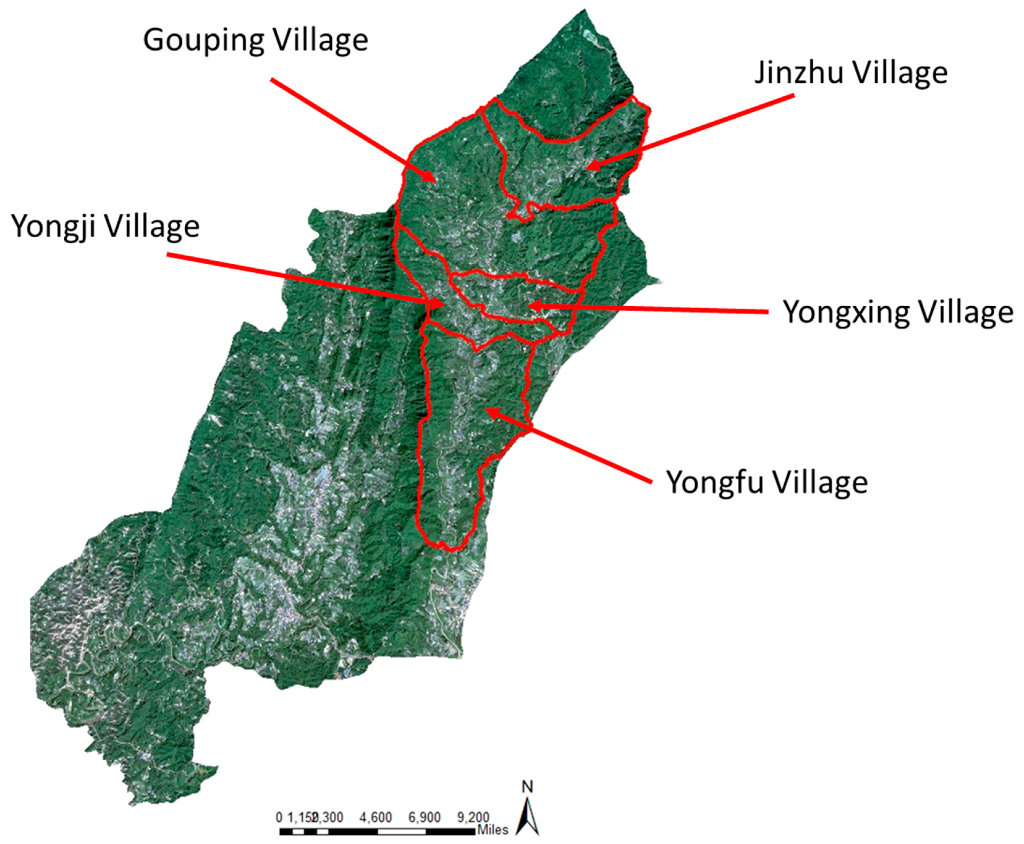
Figure 2.
Water bodies classification and buffer analysis.
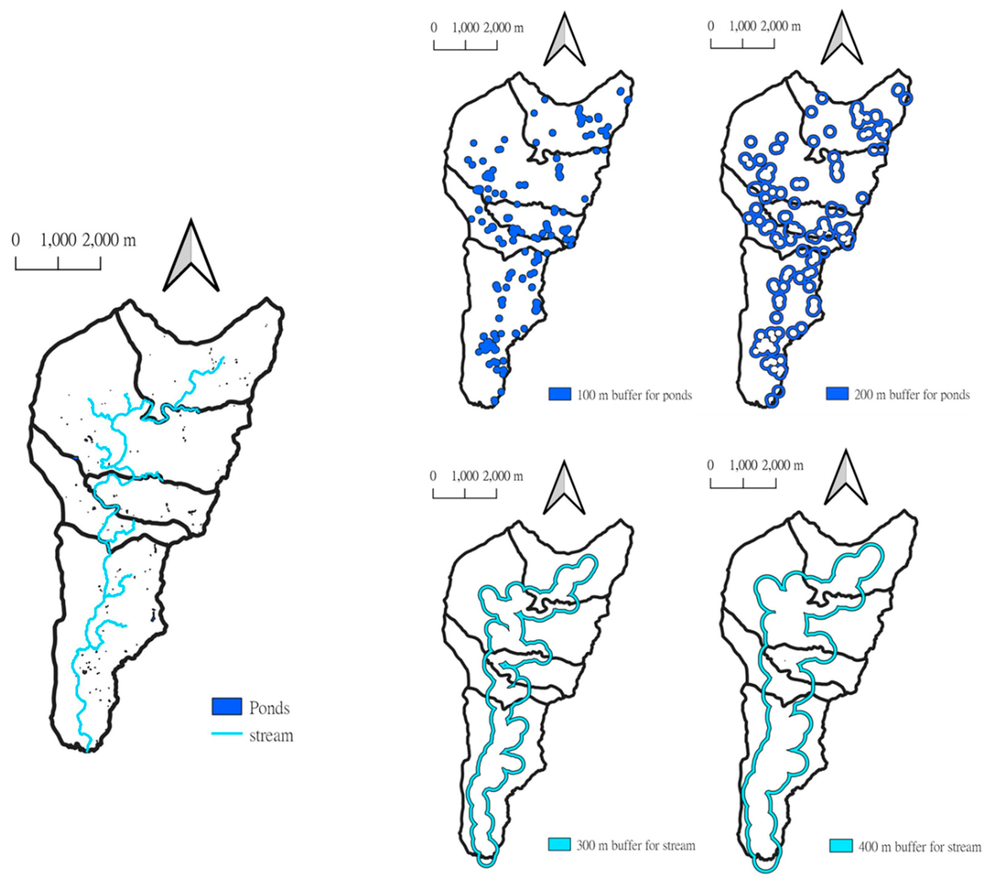
Figure 3.
Result of manager-oriented irrigation water allocation assessment.
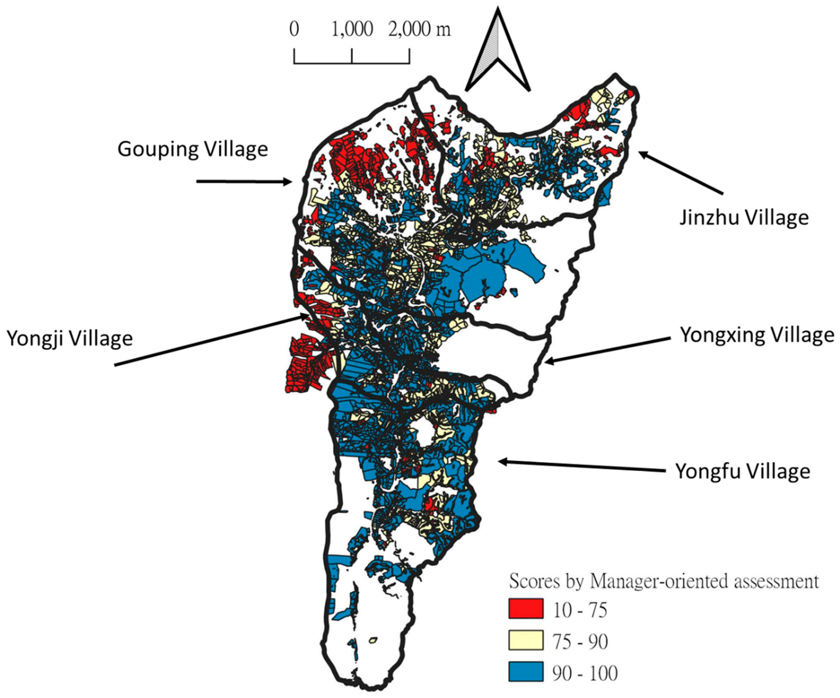
Figure 4.
Result of farmer-oriented assessment for irrigation water optimization.
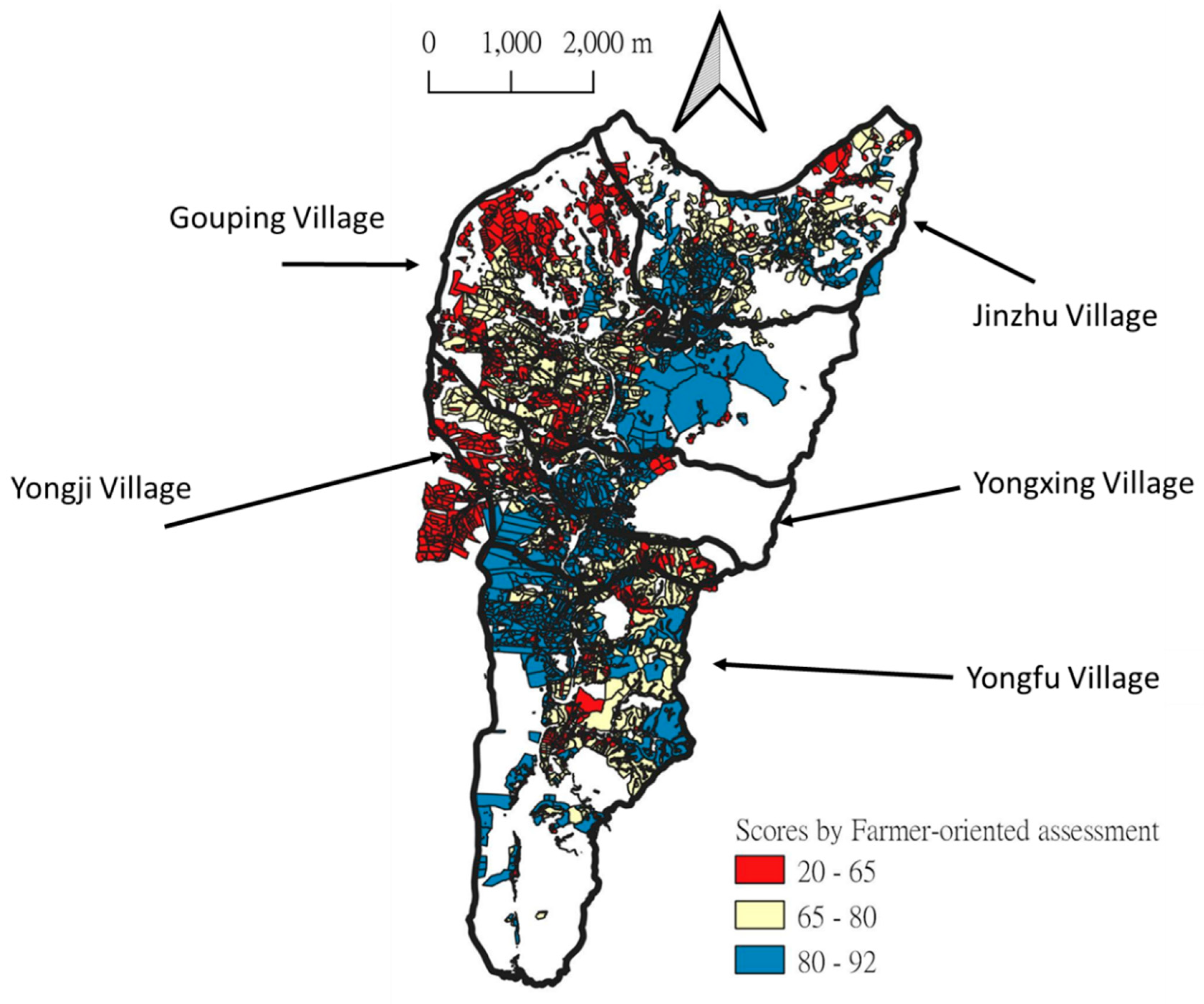
Figure 5.
12 Groups determined in this study for irrigation water allocation and optimization in research area.
Figure 5.
12 Groups determined in this study for irrigation water allocation and optimization in research area.
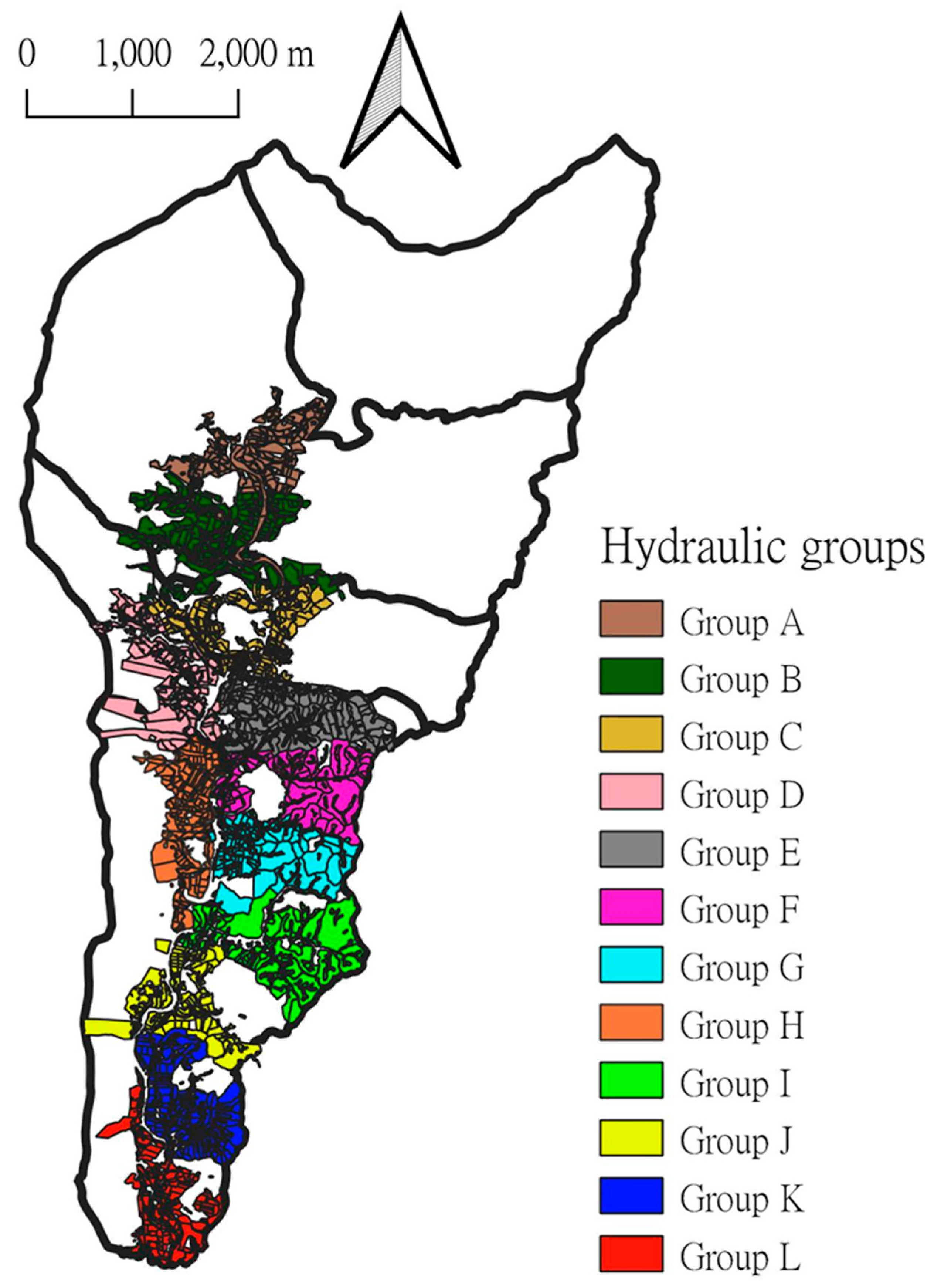

Table 1.
Manager-oriented assessment for irrigation water optimization.
| Distance to water sources (50%) | |||||
|---|---|---|---|---|---|
| Types of water sources | Distance | ||||
| < 100 m | 100 - 200m | 200 - 300m | 300 - 400m | > 400m | |
| Score | |||||
| Ponds(50%) | 50 | 40 | 30 | 20 | 10 |
| Main channel(50%) | 50 | 40 | 30 | 20 | 10 |
| Tributes (40%) | 40 | 32 | 24 | 16 | 8 |
| Streams(30%) | 30 | 24 | 18 | 12 | 6 |
| Hydraulic head (50%) | |||||
| Distance | Score | ||||
| < 1 m | 50 | ||||
| 1 – 30 m | 40 | ||||
| 31 – 60 m | 30 | ||||
| > 60 m | 10 | ||||
Table 2.
Farmer-oriented assessment system for irrigation water optimization.
| Distance to water sources (25%) | |||||||
|---|---|---|---|---|---|---|---|
| Types of water sources | Distance | ||||||
| < 100 m | 100 - 200m | 200 - 300m | 300 - 400m | > 400m | |||
| Score | |||||||
| Ponds(25%) | 25 | 20 | 15 | 10 | 5 | ||
| Main channel(25%) | 25 | 20 | 15 | 10 | 5 | ||
| Tributes (20%) | 20 | 16 | 12 | 8 | 4 | ||
| Streams(15%) | 15 | 12 | 9 | 6 | 3 | ||
| Hydraulic head (25%) | |||||||
| Distance | Score | ||||||
| < 1 m | 25 | ||||||
| 1 – 30 m | 20 | ||||||
| 31 – 60 m | 15 | ||||||
| > 60 m | 5 | ||||||
| Values of crops (15%) | |||||||
| Types of crops | Price (NTD / kg) | Score | |||||
| Longan | 53 | (53/53*15)=15 | |||||
| Litchi | 42 | (42/53*15)=12 | |||||
| Guava | 30 | (30/53*15)=8.5 | |||||
| Banana | 25 | (25/53*15)=7 | |||||
| Pineapple | 18 | (18/53*15)=5 | |||||
| Water demands of crops (15%) | |||||||
| Types of crops | Water demand (Ton / 1000m2) | Score | |||||
| Longan | 17.92 | {15/(17.92/17.92)}=15 | |||||
| Litchi | 35.84 | {15/(35.84/17.92)}=7.5 | |||||
| Guava | 53.76 | {15/(53.76/17.92)}=5 | |||||
| Banana | 17.92 | {15/(17.92/17.92)}=15 | |||||
| Pineapple | 35.84 | {15/(35.84/17.92)}=7.5 | |||||
| Soil (20%) | |||||||
| Types of soils | Retention capacity (Rank) | Score | |||||
| Red soil | 2 | 17 | |||||
| Colluvial soil | 7 | 2 | |||||
| Masonry soil | 6 | 5 | |||||
| Alluvial soil | 5 | 8 | |||||
| Clay soil | 1 | 20 | |||||
Table 3.
Cost and profit priorities of different crops with different hydraulic head to water sources.
Table 3.
Cost and profit priorities of different crops with different hydraulic head to water sources.
| Hydraulic head < 1 m | ||
|---|---|---|
| Crops | Cost (NTD/kg) | Profit priority (%) |
| Longan | 4.32 | 99.01 |
| Litchi | 4.61 | 99.98 |
| Guava | 13.93 | 89.07 |
| Banana | 27.00 | 90.99 |
| Pineapple | 27.00 | 85.77 |
| Hydraulic head from 1 m to 30 m | ||
| Crops | Cost (NTD/kg) | Profit priority (%) |
| Longan | 4.52 | 98.96 |
| Litchi | 4.66 | 99.98 |
| Guava | 14.16 | 88.88 |
| Banana | 27.80 | 90.66 |
| Pineapple | 27.80 | 85.08 |
| Hydraulic head from 30 m to 60 m | ||
| Crops | Cost (NTD/kg) | Profit priority (%) |
| Longan | 4.82 | 98.90 |
| Litchi | 4.72 | 99.98 |
| Guava | 14.50 | 88.49 |
| Banana | 29.00 | 90.32 |
| Pineapple | 29.00 | 84.13 |
Disclaimer/Publisher’s Note: The statements, opinions and data contained in all publications are solely those of the individual author(s) and contributor(s) and not of MDPI and/or the editor(s). MDPI and/or the editor(s) disclaim responsibility for any injury to people or property resulting from any ideas, methods, instructions or products referred to in the content. |
© 2023 by the authors. Licensee MDPI, Basel, Switzerland. This article is an open access article distributed under the terms and conditions of the Creative Commons Attribution (CC BY) license (http://creativecommons.org/licenses/by/4.0/).
Copyright: This open access article is published under a Creative Commons CC BY 4.0 license, which permit the free download, distribution, and reuse, provided that the author and preprint are cited in any reuse.


