Submitted:
25 February 2023
Posted:
27 February 2023
You are already at the latest version
Abstract
In an era of rapid technological improvements, state-of-the-art methodologies and tools dedicated to protecting and promoting our cultural heritage should be developed and extensively employed in the contemporary built environment and lifestyle. At the same time, sustainability principles underline the importance of the continuous use of historic or vernacular buildings as part of the building stock of our society. Adopting a holistic, integrated, multi-disciplinary strategy can bridge technological innovation with conserving and restoring heritage buildings. The paper presents ongoing research and results of the application of Machine Learning methods for the remote monitoring of the built environment of the historic cluster in Cypriot cities. This study is part of an integrated, multi-scale, and multi-discipline study of heritage buildings towards the creation of an online HBIM platform for urban monitoring.
Keywords:
Machine Learning
; remote sensing
; Sentinel-1
; Sentinel-2
; SNAP
; land cover classification
; change detection
; urban heritage
; historic architecture clusters
1. Introduction
Historic urban environments are not given static formations disconnected from the contemporary fabric of a city but rather a set of tangible and intangible assets subject to dynamic pressures of economic, environmental, and social activities. Looking beyond the important historic cities previously preserved by authorities, there are globally numerous second- and third-tier cities which have grown from their historic centers due to prior urbanisation phenomena but have faced various difficulties in safeguarding and integrating heritage buildings in the contemporary fabric of the city in a sustainable way. Such examples of cities challenged by gentrification, depopulation, and neglect can be found in Cyprus, Greece, South Italy, and elsewhere. Monitoring the pressures caused by city-wide phenomena on historic clusters can be proven helpful for local authorities in preventing future losses of building stock. Different stakeholders and professionals have used onsite analysis and earth observation methods separately. However, remote sensing and computational tools have recently enabled large-scale real-time monitoring of cities.
Developing built heritage digitization methods should focus on expanding the scope of study beyond the individual building and allowing deeper understanding and interdisciplinary interpretation of its condition and performance within its topographical context and the surrounding built environment. This could become a reality today using the advancements in remote sensing, algorithms, and the computation prowess of hardware available to researchers. Expanding the scale and area of focus of heritage studies to enable re-use and the integration of heritage in the contemporary life of a city beyond the scale of the building asset can provide researchers, professionals, and the relevant stakeholders with new insights into chronological urban studies through methods that were very resourceful and difficult to implement before.
Nowadays, as the Earth Observation data volume is growing, the need to transform this raw data into valuable products is highly required. In addition, the value of land cover and land use monitoring has increased to understand the frequent environmental changes and address the challenges of specific environmental problems. In this context, this study demonstrates a user-friendly methodology that extracts meaningful information from multi-temporal Copernicus Sentinel-1 and Sentinel-2 images to map urban growth while recording details about the spatial changes.
The paper draws on the ongoing research and intermediate results of the project “Portal for heritage buildings integration into the contemporary built environment” (PERIsCOPE) (https://uperiscope.cyi.ac.cy/), which is co-financed by the European Regional Development Fund and the Republic of Cyprus.
2. Remote sensing for built environment observation
International literature has been mainly concerned with the recent rapid increase in the urbanization of cities. The concept of smart cities appears to meet the challenges of urbanization and be the appropriate strategy to address the difficulties of urban sustainability. The three main pillars of the smart city topic seem to be IoT, big data, and theoretical analyses that include several application fields, numerous implemented case studies, and citizen-related aspects [1]. As pointed out by Yarashynskaya and Prus [2], the role of smart energy solutions is crucial for a proper Smart City function and is grounded on the escalating demand for energy in urban areas as well as the importance of energy in the development of other key Smart City sectors, such as manufacturing, construction, and housing. However, Adibhesami et al. [3] declared that the effect of sustainable energy policies on human physical and mental health should be examined, when making decisions in this domain.
Many studies have been conducted to map the results of urban growth and understand the earth's land usage and land cover (LULC) in time by modelling the changes that occur owing to artificial structures and natural phenomena. For instance, Rong et al. [4] in their research analyzed the driving factors of land use carbon emissions in the area of the lower Yellow River has experienced rapid industrialization and urbanization with drastic land use changes during 1995–2018. Jadraque Gago et al. [5] applied the maximum likelihood classifier to produce land cover maps in order to examine the relationship between the pattern of the urban fabric and the formation and evolution of the surface urban heat island (SUHI).
Remote sensing techniques have been broadly applied to built environment monitoring. The substantial increase in satellite imagery provides a large amount of data support for deep learning methods in urban monitoring and subsequently the opportunity to explore various approaches in the field of remote sensing analysis. For instance, Chen et al. [6] proposed a neural network-based method for extracting different types of urban green spaces (UGS), such as parks, using Sentinel-2 images and crowdsourced geospatial big data. Verde et al. [7] used Sentinel-1 and PlanetScope imagery to model the essential land use components required for calculating Sustainable Development Goal (SDG) 11 indicator over the Athens metropolitan area, employing deep learning techniques. For detecting building changes, Liu et al. [8] presented a technique in which shape and spatial features were used to improve the discriminability between buildings and other ground objects. Also, Luo et al.’s research focused on building extraction from remote sensing images by reviewing the most commonly used deep learning methods [9]. Change detection techniques are currently in an advanced stage and have been used to acquire land cover change information for a wide range of applications related to environmental monitoring. Li et al. [10] examined pre-processing techniques to identify newly constructed structures using differences between two Sentinel-1 imageries of Nanjing City. In this study, SAR images were used, owing to their ability to penetrate cloud cover and their insensitivity to atmospheric and lighting conditions. Papadomanolaki et al.’s [11] research presented a deep-learning architecture for urban change detection using the Onera Satellite Change Detection dataset (OSCD). The proposed method combines a U-Net architecture with Long Short-Term Memory (LSTM) blocks.
In this context, a widely used tool is SNAP [12], a standard, open-source operational platform dedicated to Sentinel data exploitation. For instance, Radudu et al. [13] used Sentinel-1 products for three years (2016-2019) to analyze the dynamics of the Bucharest city population using change detection techniques in SNAP. SNAP's change detection process has also been applied in other scientific fields. For example, Sreechanth S and Kiran Yarrakula [14], in their research (2017), used the SNAP platform for flood inundation mapping. In their study, the SVM classification was performed to map flooded regions and existing water bodies, and the changes were detected by the image differencing method.
The protection and preservation of cultural heritage and historical sources is a topic that garnered a lot of research attention, especially in Europe. A survey focused on presenting a clearer picture of the potential and challenges that can occur during the implementation of fuel-free approaches for projects within a historic city center was conducted by Simeone et al. [15]. Chahardowli et al.’s paper presents a thorough analysis of urban regeneration as a multifaceted strategy for revitalizing cities' historic cores. They point out that sustainable regeneration is the outcome of the interaction of four physical, economic, social, and cultural components that support the revitalization of urban historic clusters [16]. Lastly, occupied with the region of Cyprus, Agapiou [17] used optical and radar data to map the vegetation cover in the vicinity of archaeological sites and landscapes, such as "Nea Paphos" and "Tombs of the Kings”.
3. Research aim
The research argues that by leveraging multi-scale knowledge with the support of digital tools, it is possible to establish more accurate monitoring strategies for authorities and critical city stakeholders and help them prioritize relevant policies and incentives for the sustainable management and development of historic clusters in cities. The presented application of machine learning methods in remote sensing datasets of urban environments in Cyprus was developed to support the authorities' officers before interacting with a platform that combines 3D GIS data used for the generation of a baseline model of the urban fabric, provided by Cyprus Land and Survey Department, with 3D models of the building blocks under study. These datasets become accessible via an online platform (https://uperiscope.eu/) that enables multi-scale monitoring of heritage buildings by means of remote sensing, as well as three-dimensional and reality-captured representations of the built environment. Specifically, this online platform relies on an agile workflow that involves the following steps:
- a)
- Initial urban scale monitoring of built environment transformations, which natural or human activities may induce. Identifying changes in annotated assets of the built environment through a semi-automated workflow that enables comparing remote sensing data from different periods can provide the users with a quick way to link large-scale urban phenomena to onsite building observation studies and hypotheses.
- b)
- Climatic analysis of the site: a contextual survey of the conditions of the surrounding built environment of the heritage buildings under study through remote sensing. This study regards information about the local environment, climatic and topographic conditions of the area at the scale of the neighbourhood, and the assessment of change in environmental conditions in time.
- c)
- The survey stage, which includes a conservation state analysis based on non-destructive, diagnostic investigations on building structure and degradation (material, structural, morphological), looking at hygrothermal properties, decay phenomena and crack pattern analysis, and the identification of moisture presence, being documented and classified by possible cause, through visual means and textual interpretation.
- d)
- The next stage of the multi-scale advanced survey includes the direct study of the building: e.g., topometric and photographic survey, and analysis of formal, constructive, and material aspects, i.e., Terrestrial Laser Scanning and photogrammetric surveys of the building, in order to produce 3D point-cloud models to be used in the HBIM, and also to support the conservation state analysis with accurate information that is a prerequisite for any energy upgrade, or retrofit, intervention.
This paper will be occupied with the first step in the process, which regards the initial urban scale monitoring of built environment transformations.
4. Objectives
Through state-of-the-art remote sensing monitoring and onsite analytical digital tools and methodologies, this data-driven observation of historical buildings would enable relevant stakeholders to monitor the stability of their structural elements and to understand in time significant decay risks, neglect, or real estate development and urbanization pressures that may cause damage to or threaten the building stock. In order to support this aim, the presented research pursues the following objectives to enable remote sensing monitoring of the built environment under study:
- 1)
- As many studies have focused on change detection with a visual interpretation of the outputs, the proposed methodology addresses the need for combinational approaches by integrating robust supervised land cover classification procedures with the use of coherent log likelihood and image differencing change detection techniques. This combination transforms the results into meaningful insights into the urban landscape. To this end, the key advantages of using Sentinel-1 and Sentinel-2 images and performing and evaluating automatic, supervised and unsupervised machine learning algorithms are: time reduction, flexibility in data exploration with multiple solutions, and multilevel similarity modelling.
- 2)
- The analysis of open-access radar and optical products using freely available platforms such as SNAP, QGIS and Google Earth, encourages the usage of open data in the urban planning field.
5. Case study
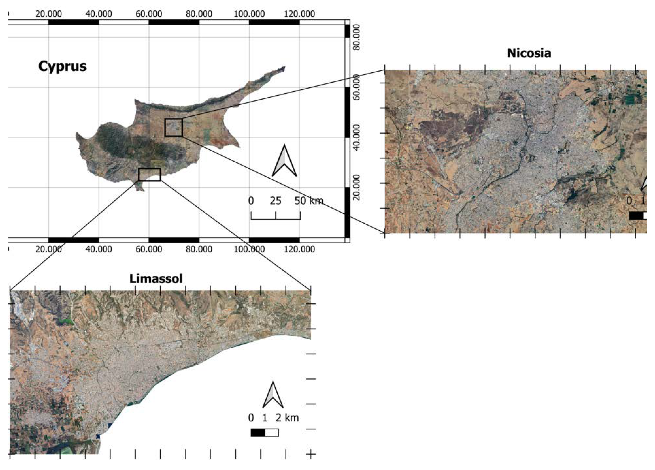
The two pilot study areas of the research were carefully selected to allow a comparative understanding of the impact of environmental change and climatic conditions on building assets. Hence the two clusters studied are located in two urban environments in different climatic zones and seismic activity, in Limassol and Nicosia. Specifically, the testbed areas are the historic cluster of Strovolos, Nicosia, and examples in the old city and Turkish-Cypriot quarter of Limassol. Old Strovolos covers an area of approximately 50 Hectares, having a population of around 2.500 inhabitants (2011 census), the majority of whom are of Cypriot origin, settled in around 1.000 dwellings. It is a part of Strovolos Municipality Urban Area, the second largest municipality of Cyprus, with a total population exceeding 70.000 inhabitants. The Turkish Cypriot quarter of Limassol covers an area of approximately 35 hectares population of around 1.400 inhabitants (2011 census), Greek Cypriot refugees and economic emigrants of various origins settled in approximately 500 dwellings. It is a part of Limassol Municipality Urban Area, the largest municipality of Cyprus with a total population exceeding 100.000 inhabitants. The chosen study area is covered by ascending and descending passes of Sentinel-1 SAR images and Sentinel-2 multispectral images.
Figure 1.
Cyprus and the Areas of Interest (satellite images).
6. Method: Remote Sensing Analysis at Neighbourhood Scale
6.1. Data Collection
Synthetic Aperture Radar (SAR) images and optical data are used to monitor and analyze the urban fabric of the cities of Cyprus. The Sentinel-1 and Sentinel -2 satellite images were downloaded using the Copernicus Open Access Hub (https://scihub.copernicus.eu/dhushttps://scihub.copernicus.eu/dhus) operated by the European Space Agency (ESA). Specifically, the two Sentinel-1 Ground Range Detected – High Resolution (GRDH) images were acquired on 06/10/2016 and 29/09/2022. Detailed properties of the data are shown in Table 1. In order to devise a strategy for the operational exploitation of both radar and optical data in the frame of urban mapping, Sentinel-2 data were also required. In an ideal process, the images of both sensors should be acquired at the same time. To ensure that each pixel's information refers to the same state of the earth's surface, the duration between the two image products should be reduced to a minimum. Subsequently, for the classification application, a margin of ±1 month from the sensing date of the Sentinel-1 image was used to select the corresponding optical image. Moreover, since this kind of image=based documentation is prone to feature clouds that cover the earth surface, cloud-free images were selected for the purpose of this study. Thus, the Sentinel-2 Level 2A image was acquired on 25/10/2022, with a descending orbit direction and with a cloud cover percentage equal to 0.41%. Lastly, as no Level 2A products are available for the target area on 2016, Level 1C image was used for the change detection. So, for the analysis of Limassol, the Sentinel-2 Level 1C image has sensing date of 16/10/2016 and for the area of Nicosia has sensing date of 08/11/2022.
Additionally, Open Street Map [18] labelled datasets were used to train the supervised classifiers, and Google Earth data were used for accuracy assessment and visual interpretation of the results.

Table 1.
SAR Data specifications.
| Date of dataset | Sensor | Product type | Sensor mode | Polarization | Orbit direction |
| 6 October 2016 | Sentinel-1A | GRD | IW | VV+VH | descending |
| 29 September 2022 | Sentinel-1A | GRD | IW | VV+VH | descending |
Figure 2.
Intensities of Sentinel-1 product with dual polarization.
6.2. Sentinel-1 Images Pre-processing
Before using the Sentinel-1 products, it was necessary to apply identical pre-processing procedures to all the scenes. The pre-processing and analysis of the images were conducted in Sentinel Application Platform (SNAP) software. SNAP is a scientific image-processing toolbox for Earth Observation studies [19]. During the image pre-processing, several procedures were carried out. Figure 3 summarizes the methodology steps of the pre-processing analysis of Sentinel-1 SAR data.
Figure 3.
Pre-processing workflow of SAR images.
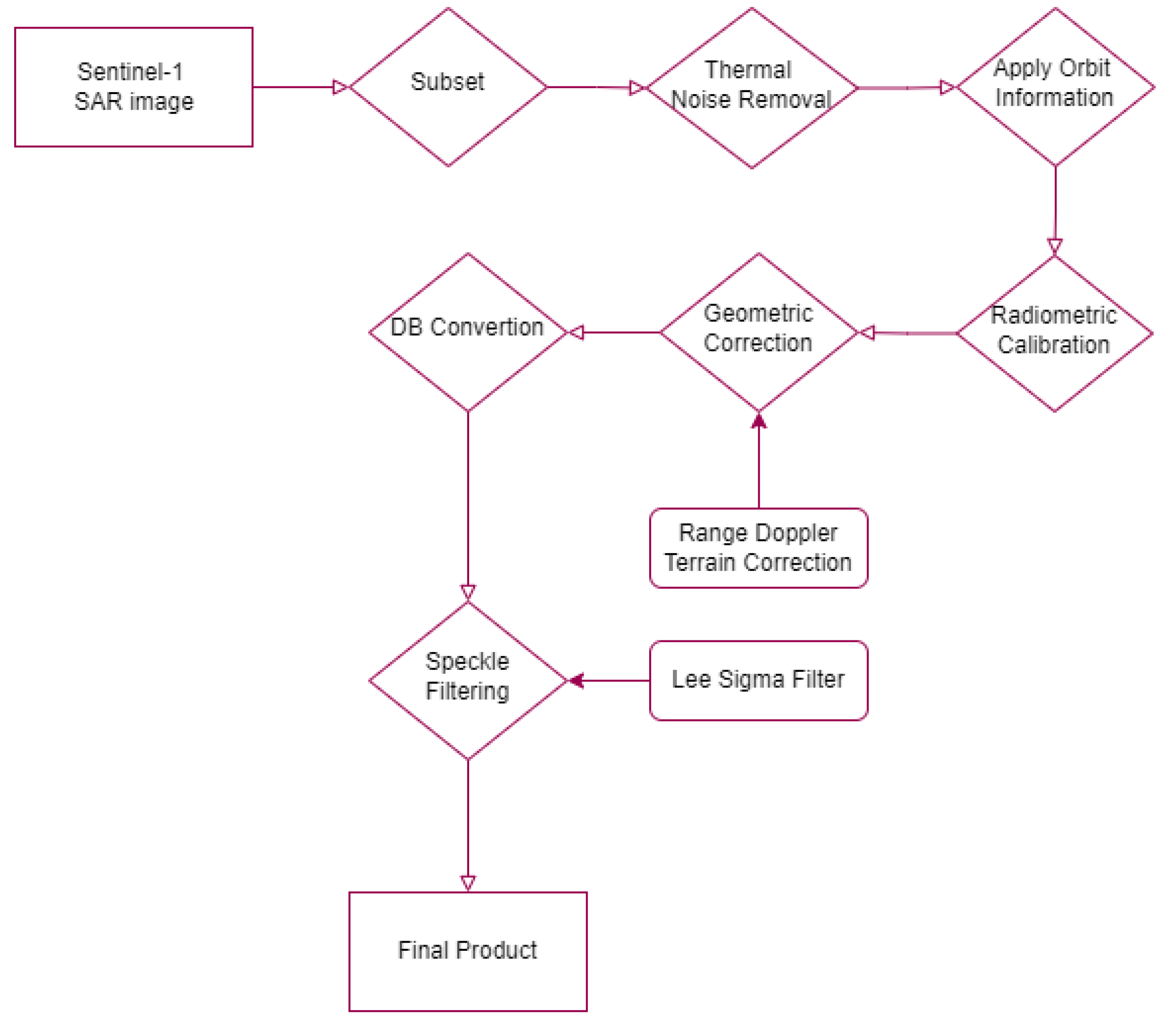
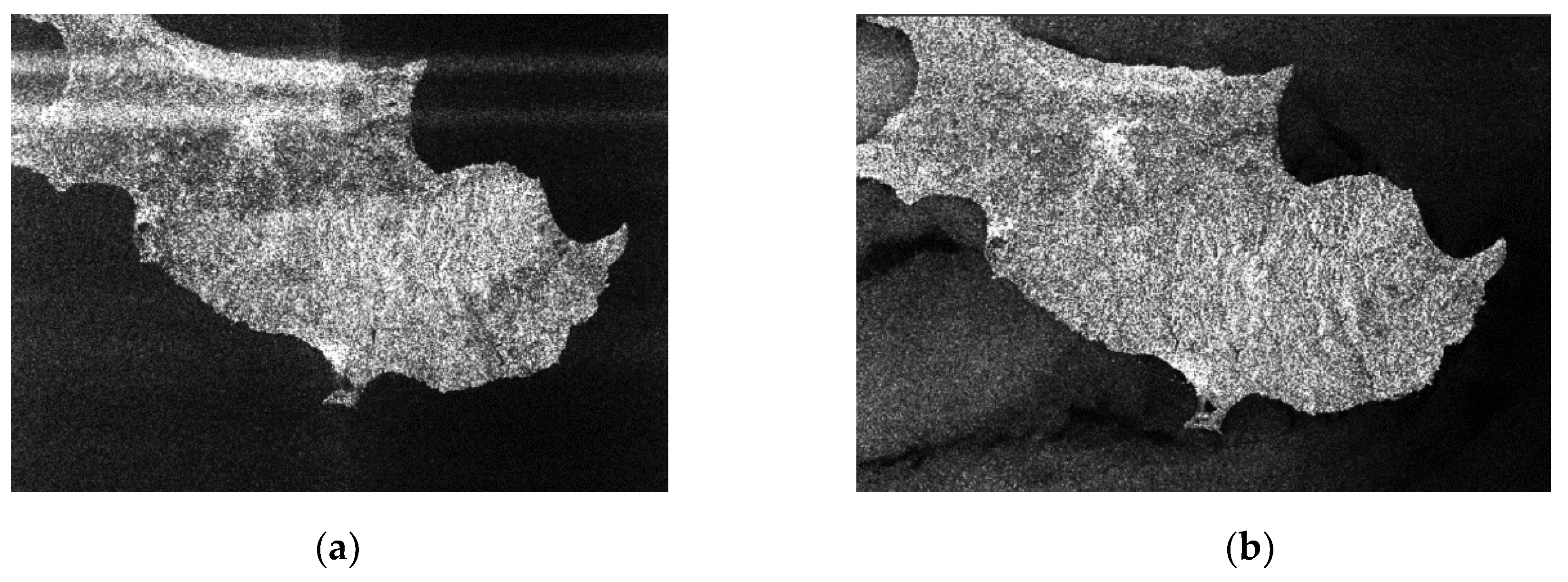
Co-polarization (VV) is used in this study because of its higher sensitivity to urban structures. To reduce the loaded data to the area of interest, decrease errors, and speed up processing, a subset is required. In the case of the presented research, this was the capital of Cyprus, Nicosia, and the surrounding area. The next step is removing thermal noise using the noise look-up table (LUT) file provided for each product. Radiometric calibration is critical to collocate radar images of various dates, sensors, or imaging geometries. By utilizing a digital elevation model (DEM) to correct SAR geometric errors, Geometric Correction geocodes the image and creates a map-projected output [20]. Additionally, the logarithmic function is applied to the images via the conversion to dB scale, proceeding for a normal distribution of the backscatter intensity to be achieved. Following an evaluation of the available filters (Figure 4), the final phase of pre-processing was the improvement of image quality by speckle filtering. Lee Sigma filter was selected since it preserves edges and eliminates the haziness of the image [21].
Figure 4.
Speckle filtering comparison: (a) Lee Sigma; (b) Lee; (c) Frost; (d) Refined Lee.
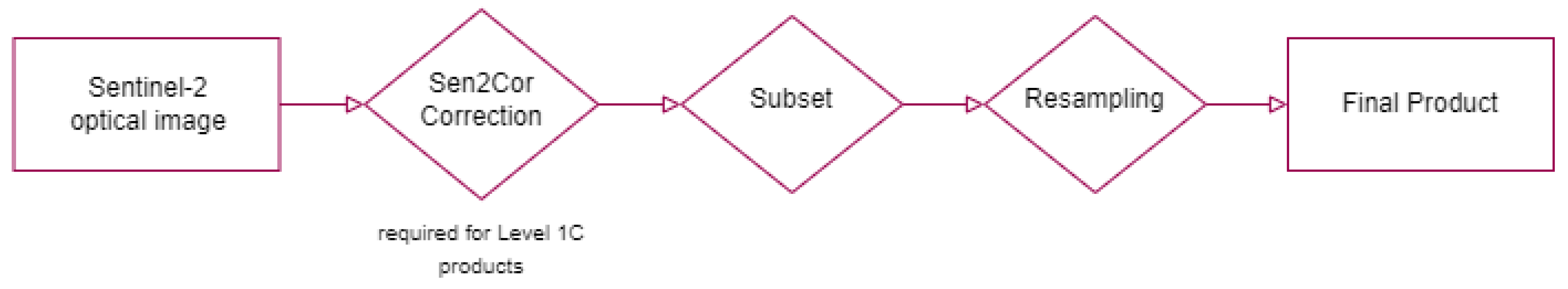
6.3. Sentinel-2 Images Pre-processing
In the case of optical data, the pre-processing procedures and calibrations are also necessary to properly work with the images. The following diagram (Figure 5) summarizes all the steps in the preprocessing chain. For Sentinel-2 Level-1C products, the first step of the analysis is the implementation of Senc2Cor processor. Sen2Cor is a Level-2A generator whose primary purpose is to correct Sentinel-2 Level-1C Top-of-Atmosphere (TOA) data from single-date atmospheric influences in order to deliver a Level-2A Bottom-of-Atmosphere (BOA) reflectance product [22]. As the dataset consists of Level-2A images at this point, the next step is the creation of a subset, with the use of spectral bands. Lastly, as not all bands in the Sentinel-2 product have the same resolution, combining some bands during the exploration could cause issues. To combat this, the resampling step is fundamental and it was applied with the use of B2 as the reference band and the nearest neighbor technique as the upsampling method.
Figure 4.
Pre-processing workflow of optical images.
6.4. Landcover Classification
The classification methodology of this study consists of two main parts, the analysis conducted in Sentinel-1 and Sentinel-2 products individually, and the synergetic use of optical and radar data.
Random Forest and Maximum Likelihood supervised machine learning algorithms are utilized to classify SAR images. Maximum likelihood classification determines the likelihood that a given pixel belongs to a certain class under the assumption that the statistics for each class in each band are normally distributed. [23]. In addition, the Random Forest classifier uses different data subsets of both the input bands and the training pixels to determine the most reliable thresholds based on the input features with the highest prediction importance [24].
Multi-sensor image fusion techniques combine two or more geometrically registered images of the same scene into a single image that is more easily interpreted than any of the originals. Existing fusion techniques combine data from various sensors to take advantage of their complementary information content, generally at the pixel level. Consequently, the combination of SAR and optical features follows below, in order to examine if the feature fusion of Sentinel-1 and 2 can improve the accuracy of the method for urban mapping, and in order to select the optimal algorithm based on the experiments conducted. For this reason, urban and vegetation indices were also computed. Specifically, the Index-based Built-up Index (IBI), Normalized Difference Built-up Area Indicator (NDBI), Urban Index (UI), and Normalized Difference Vegetation Index (NDVI) were used in the process. The IBI, NDBI, and UI are indices for quickly mapping built-up areas. In contrast, the NDVI is a well-known spectral index for mapping the distribution of vegetation and a variety of conditions over land surfaces. In the past though, the NDVI was also applied for mapping the impervious area of urban areas. As the Modified Normalized Difference Water Index (MNDWI) is suitable for the enhancement of open water features and the extraction of water bodies, it was applied here in the analysis of the project area in Limassol. In the presented process, the calculation of the spectral indices was followed by the classification process. In this step, all the source bands were used, including the ratio band created by the SAR image and the spectral indices. Numerous experiments were carried out to discover the most accurate and suitable combination of indices.
One of the most fundamental parts of the classification process is the collection and analysis of training samples. In the presented case, the training data were grouped into three main categories (buildings, vegetation, and water), based on the city's urban structure and the scope of the study. These groups were categorized in the QGIS environment [25] for processing flexibility and future management of geodata, including cross-platform integration and open data provision, to ensure the results of this activity can be integrated into the online PERIsCOPE project platform.
6.5. Change Detection
According to Singh [26], change detection is the process of identifying differences in the state of an object or phenomenon by observing it at different times. Over the past decades, many detection techniques and methods have been developed in order to analyze the frequent environmental changes and overcome the challenges of particular environmental concerns. Lu et al. [27] refer that change detection methods are grouped into seven categories: algebra, transformation, classification, advanced models, geographic information system (GIS) approaches, visual analysis, and other approaches.
Applying multi-looking and co-registration of the calibrated products results in having the temporal images connected and preparing them for further analysis. In the case of SAR images, the SNAP change detection module is applied in the stacked output. The SNAP change detection tool is based on log-likelihood estimation, which is the difference between the log intensity estimates. In this way, the areas of major change were highlighted. The results were vectorized and displayed in the QGIS [25] environment.
In the case of optical products, image differencing was applied, a widely used technique for many applications involving change detection. Close et al [28] showed that image differencing achieves one of the highest overall accuracy scores (94%).
where B corresponds to the different bands of Sentinel-2 images (B2, B3, B4, B5, B6, B7, B8, B11 and B12) of the collocation of 2016 and 2018 images. In this equation, the normalized squared difference was applied, which rescales the values into a range of 0 to 1. The normalized squared difference facilitates the thresholding since it regroups the change pixels distributed initially in the tails of the distribution curve around the mean to a unique direction. After the comparison of the differences of the various bands, the B8 was selected. Once the created index is differenced, the resulting image values are then thresholded to identify areas of change.
7. Results
The results of this study are presented here in two parts. The first part describes the land cover classification outputs in the areas of interest, and the second part deals with the change detection in the urban regions.
7.1. Land Cover Analysis
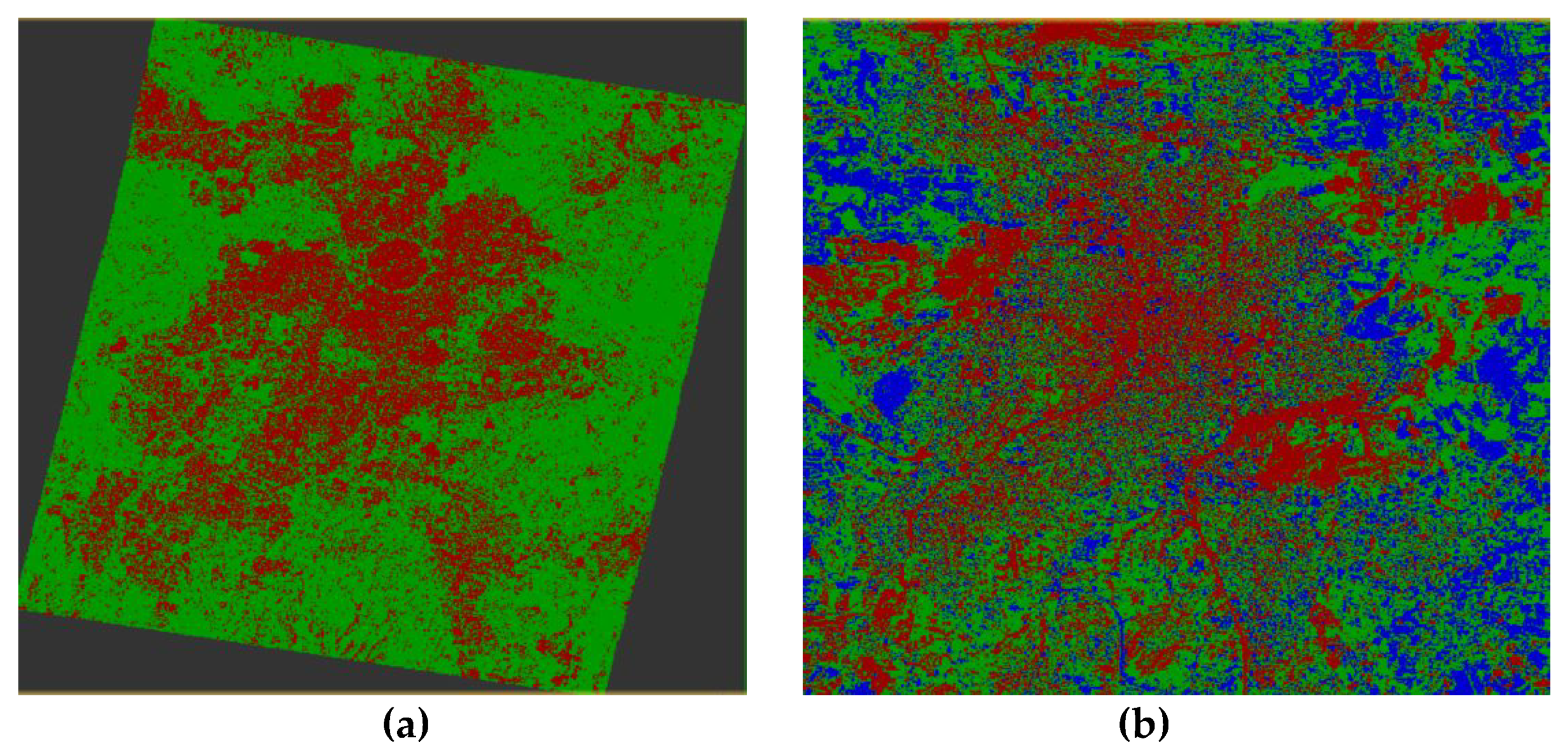
Comparing the two supervised machine learning approaches is required to determine the most effective in the areas under study. In addition, Sentinel-2 images were included in this procedure to achieve the finest results possible. The final classified images and the detailed outcomes of the algorithms are presented in Figure 5 and Figure 6 for both urban areas under study.
Figure 5.
Comparison of Supervised Classifiers in Limassol: (a) Result of Random Forest Classifier; (b) Result of Maximum Likelihood Classifier; (c) Percentage of Land Cover - RF; (d) Percentage of Land Cover - M.
Figure 5.
Comparison of Supervised Classifiers in Limassol: (a) Result of Random Forest Classifier; (b) Result of Maximum Likelihood Classifier; (c) Percentage of Land Cover - RF; (d) Percentage of Land Cover - M.
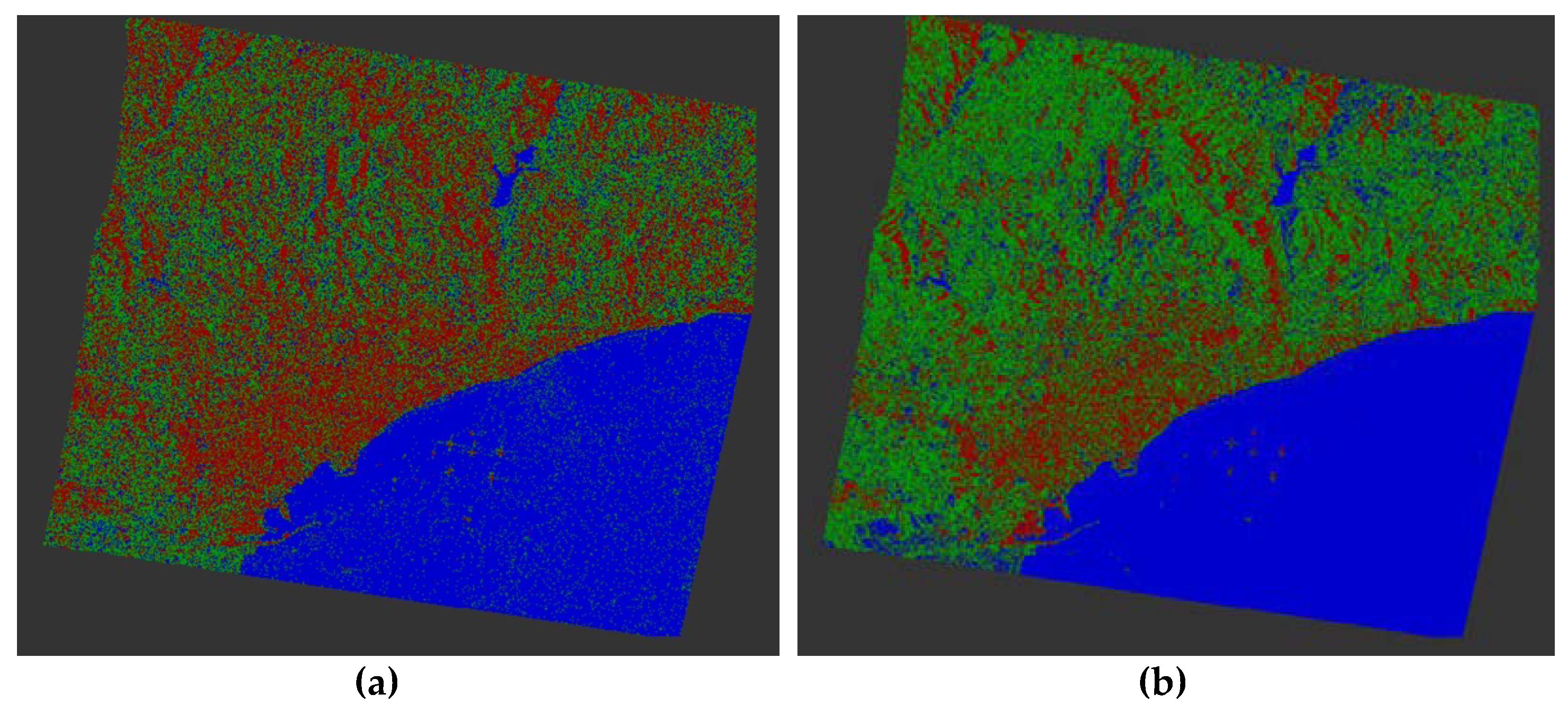
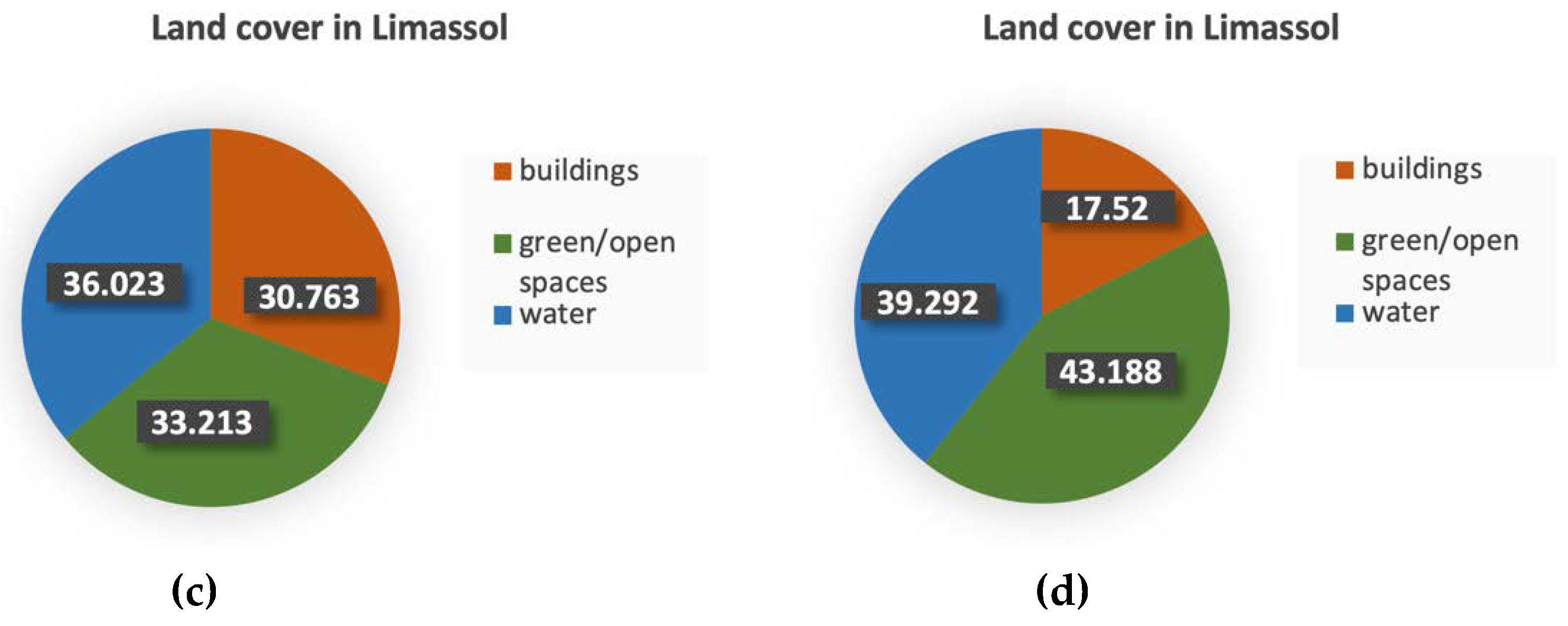
According to the evaluation of the classifiers, the Random Forest algorithm performs better than the Maximum Likelihood algorithm, especially for the urban category. The overall accuracy of 85.01% manifests how well the training data was classified based on the hierarchical thresholding of the Random Forest.
Figure 6.
Comparison of Supervised Classifiers in Nicosia: (a) Random Forest – Sentinel-1; (b) Maximum Likelihood – Sentinel-1; (c) Random Forest – Sentinel-2; (d) Land Cover – RF; (e) Land Cover - ML; (f) Land Cover – S2/RF.
Figure 6.
Comparison of Supervised Classifiers in Nicosia: (a) Random Forest – Sentinel-1; (b) Maximum Likelihood – Sentinel-1; (c) Random Forest – Sentinel-2; (d) Land Cover – RF; (e) Land Cover - ML; (f) Land Cover – S2/RF.

In the case of Nicosia, the Random Forest classifier was also applied in Sentinel-2 optical products, using the 2,3,4,8,11, and the 12th band. It is concluded that the Random Forest algorithm utilized in Sentinel-2 produces the best results based on the visual interpretation of the classified images (Figure 6) and the evaluation of the methods. Table 2 presents the different accuracy metrics for the 3 trained classes.
Table 2.
Training accuracy metrics for the three classifiers.
| buildings | open/green spaces | water | |||||||
| RF-S1 | ML-S1 | RF-S2 | RF-S1 | ML-S1 | RF-S2 | RF-S1 | ML-S1 | RF-S2 | |
| accuracy | 0.794 | 0.845 | 0.940 | 0.692 | 0.744 | 0.925 | 0.819 | 0.881 | 0.980 |
| precision | 0.707 | 0.846 | 0.930 | 0.570 | 0.611 | 0.915 | 0.688 | 0.831 | 0.970 |
| correlation | 0.646 | 0.702 | 0.886 | 0.537 | 0.602 | 0.860 | 0.630 | 0.730 | 0.866 |
| error rate | 0.206 | 0.155 | 0.060 | 0.309 | 0.256 | 0.074 | 0.181 | 0.120 | 0.020 |
| True Positives | 727 | 695 | 947 | 572 | 782 | 919 | 520 | 572 | 154 |
| False Positives | 302 | 127 | 80 | 432 | 497 | 86 | 236 | 116 | 7 |
| True Negatives | 1487 | 1662 | 1113 | 1357 | 1292 | 1107 | 1764 | 1884 | 1993 |
| False Negatives | 273 | 305 | 52 | 428 | 218 | 80 | 269 | 217 | 38 |
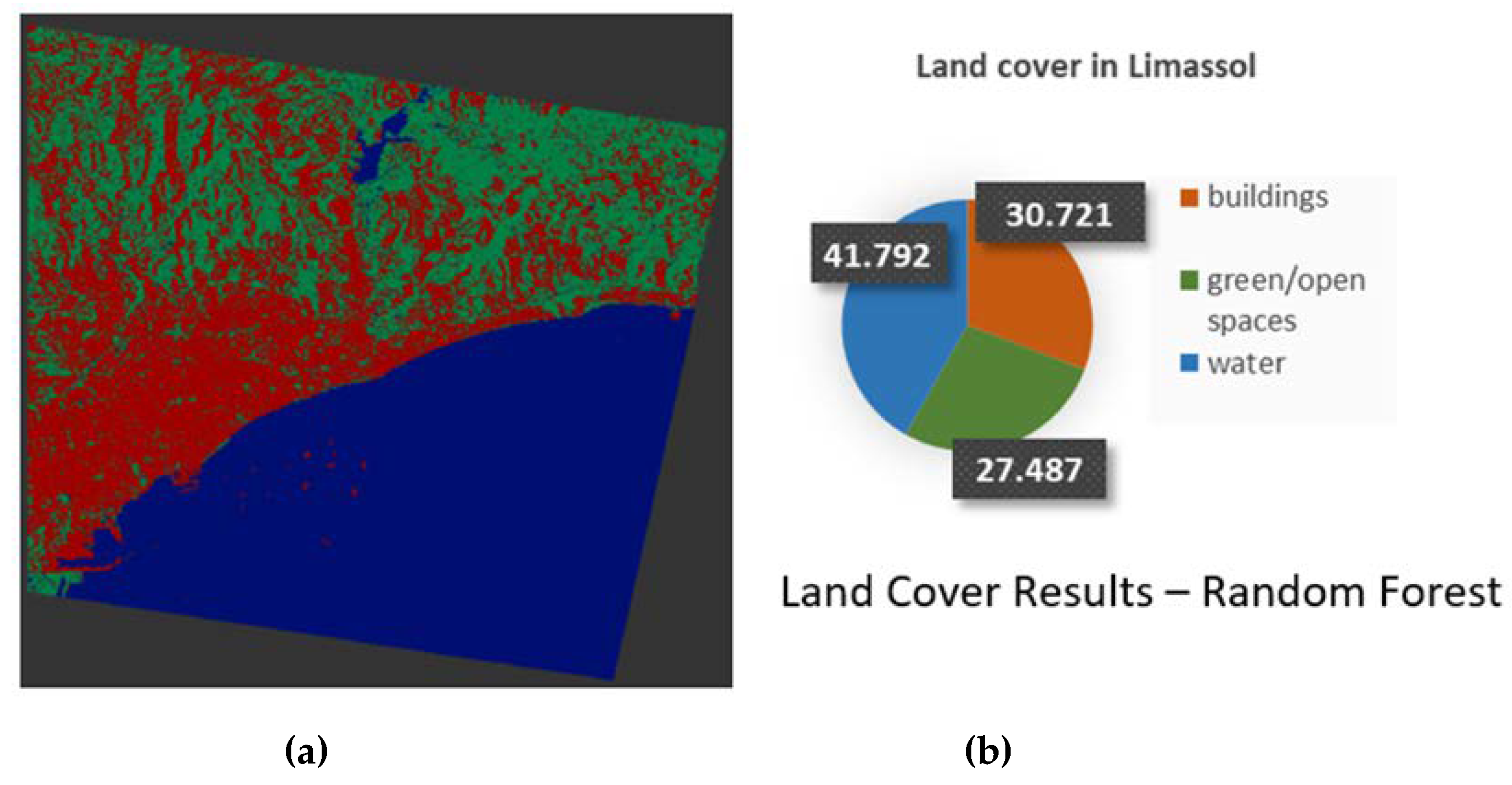
During the procedure of joint use of Sentinel-1 and Sentinel-2 data, various combinations of source bands and spectral indices were performed. It is concluded that in the case of Limassol the finest classification output was achieved with the use of all radar and optical bands and also the NDBI, IBI, NDVI, UI, and MNDWI indices. Based on the classifier evaluation the overall accuracy is equal to 90.40%. The output demonstrates that the synergetic methodology outperforms in the area of Limassol, as the percentage is higher by 5%. The classification output is displayed in Figure 7.
Figure 7.
Classification Results in Limassol from the synergetic use of SAR and optical data: (a) Random Forest output; (b) Land Cover.
Figure 7.
Classification Results in Limassol from the synergetic use of SAR and optical data: (a) Random Forest output; (b) Land Cover.
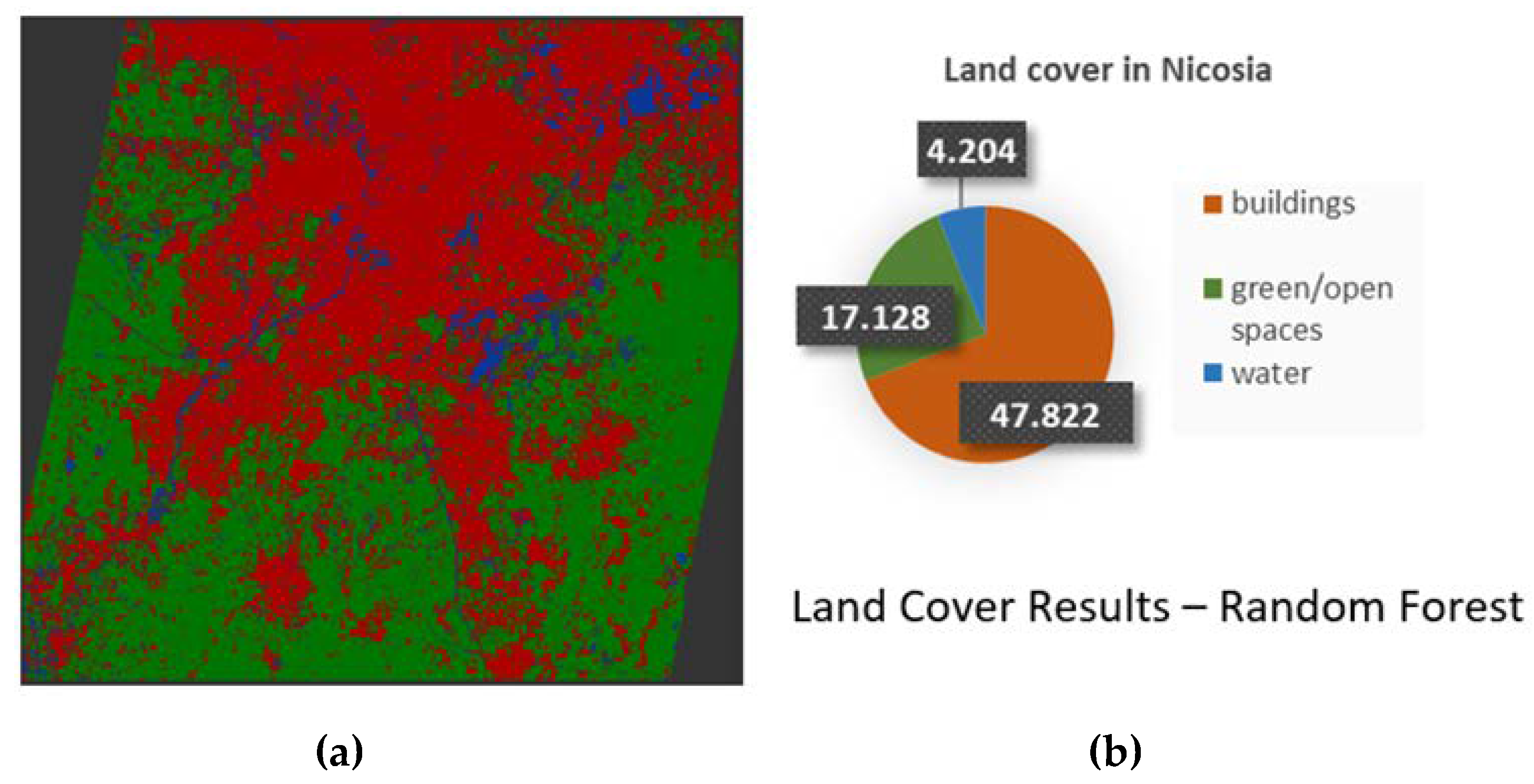
Based on the assessment and the interpretation of the classification maps, the Random Forest algorithm applied on all radar and optical bands, while the NDBI, IBI, NDVI, and UI spectral indices, deliver the optimal outcome. This combination achieved an overall accuracy of 94.10%. The high accuracy of the classifier compared to the previous results in the case of Nicosia (91%), indicated that the joint use of Sentinel-1 and Sentinel-2 products achieves the highest performance - Figure 8 provides the classified image. The most accurate classification maps were used in the following steps.
Figure 8.
Classification Results in Nicosia from the synergetic use of SAR and optical data: (a) Random Forest output; (b) Land Cover.
Figure 8.
Classification Results in Nicosia from the synergetic use of SAR and optical data: (a) Random Forest output; (b) Land Cover.
7.2. Change Detection
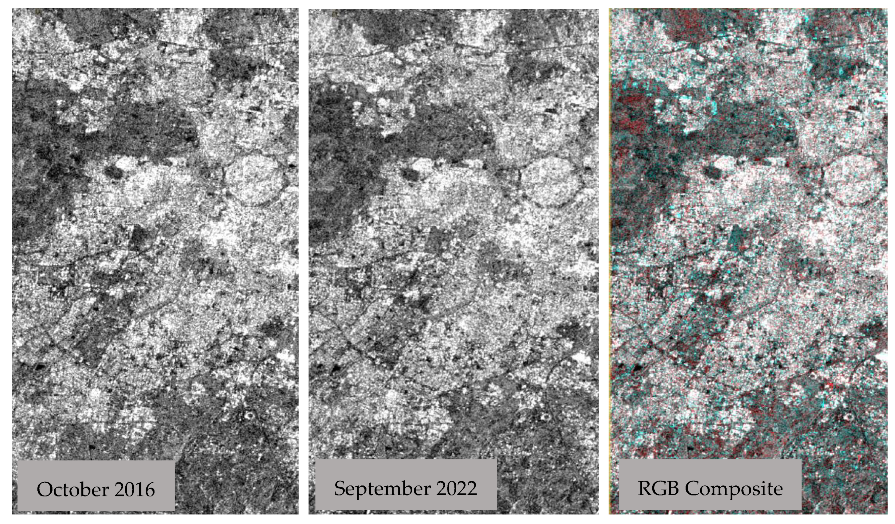
Multi-temporal color composite images can be used to visualize the land usage of an area. This method suggests the use of images of different dates in the construction of a color composite that produces an image in which features changing through time are displayed as various colors and areas of no change are displayed as gray tones. Specifically, the red color in the images presented indicates the changes that occurred over the period of coverage. This step is useful to obtain a better understanding of the changes that occurred. For example, Figure 9 displays the RGB composite and, therefore the locations of Nicosia that changed between 2016 and today.
Figure 9.
Visualization of Changes in Nicosia – RGB Composite.
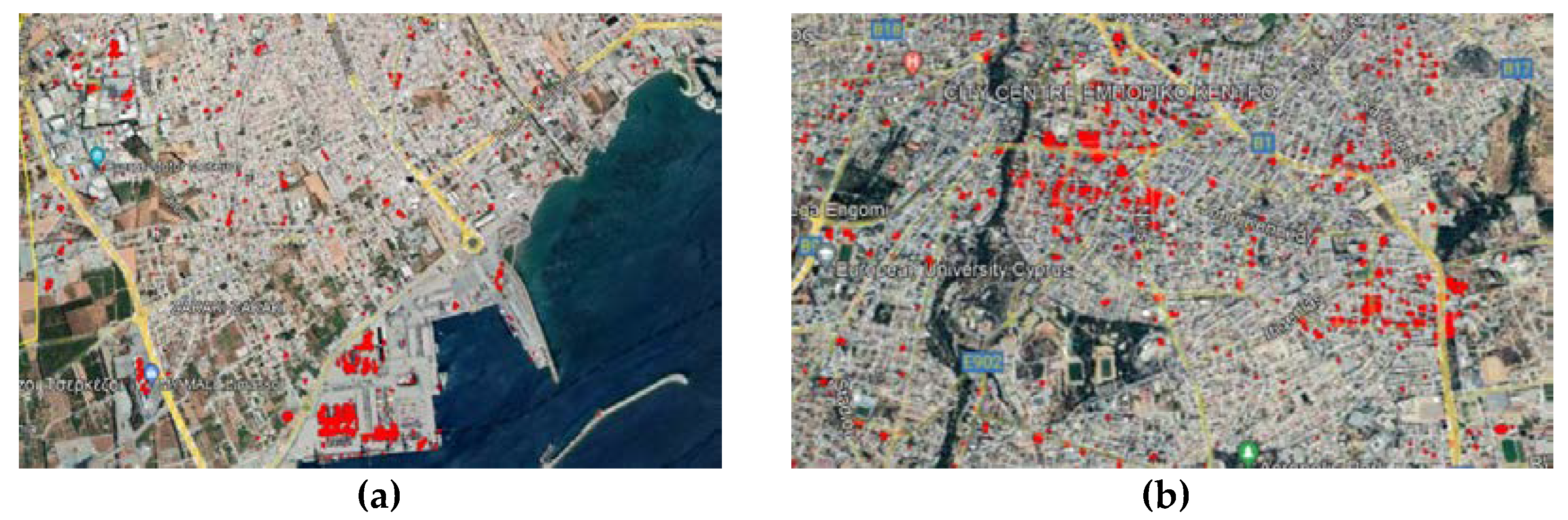
The following step is the change detection tracking in SAR images. The procedure includes the implementation of the change detection SNAP module in the created stack that contains the corrected radar images of 2016 and 2019. The result is a ratio band, which indicates the differences in the dB values from the before and after images. Figure 8 shows the visualization of the changed pixels in Google Earth. The detected changes are marked in the figure in red.
Figure 8.
Changes tracked in SAR images visualized on Google Earth: (a) Limassol; (b) Nicosia.
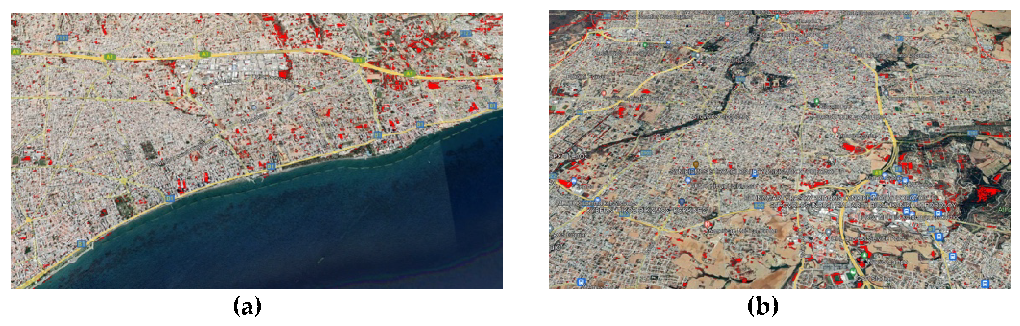
Change Detection techniques in Sentinel-2 images were also applied to enrich the results. The normalized squared difference was performed in the areas of Nicosia and Limassol under study, and the outputs were extracted as Geotiffs and KML file formats. The tracked changes in both cities on Google Earth environment are illustrated in Figure 9. In the case of Limassol, the pixels that correspond to the sea were removed in order for the algorithm to focus on the urban fabric of the city.
Figure 9.
Changes tracked in optical images visualized on Google Earth: (a) Limassol; (b) Nicosia.
Subsequently, the output data were transferred from SNAP into the QGIS environment as a GeoTIFF file for post-processing to generate valuable urban change detection maps. Open Street Map was used as the base map for representative visualization of the results. The vectorization of the raster data was considered necessary to overlay the changed parts with the corresponding classified images. As a result, the changes were then categorized, and the areas of the built environment that changed the most during the past 6 years were highlighted. Figure 10 shows a change detection map of Nicosia and Limassol produced by SAR data, combined with the classification results. Figure 21 illustrates the changes generated by optical data in both cities.
As indicated in both Nicosia and Limassol, the areas with noticeable difference readings are detected in the class of buildings. This fact confirms the dynamic of urban growth, as described in previous sections. In addition, it is clear the percentage of tracked changes obtained from the SAR images is higher. This fact confirms the conclusion of Li et al. [10], that multi-temporal SAR images are the most suitable choice for change detection applications.
Figure 10.
Change detection maps produced by SAR data wherein polygons of changes are overlaid with the classification results: (a) Nicosia; (b) Limassol.
Figure 10.
Change detection maps produced by SAR data wherein polygons of changes are overlaid with the classification results: (a) Nicosia; (b) Limassol.
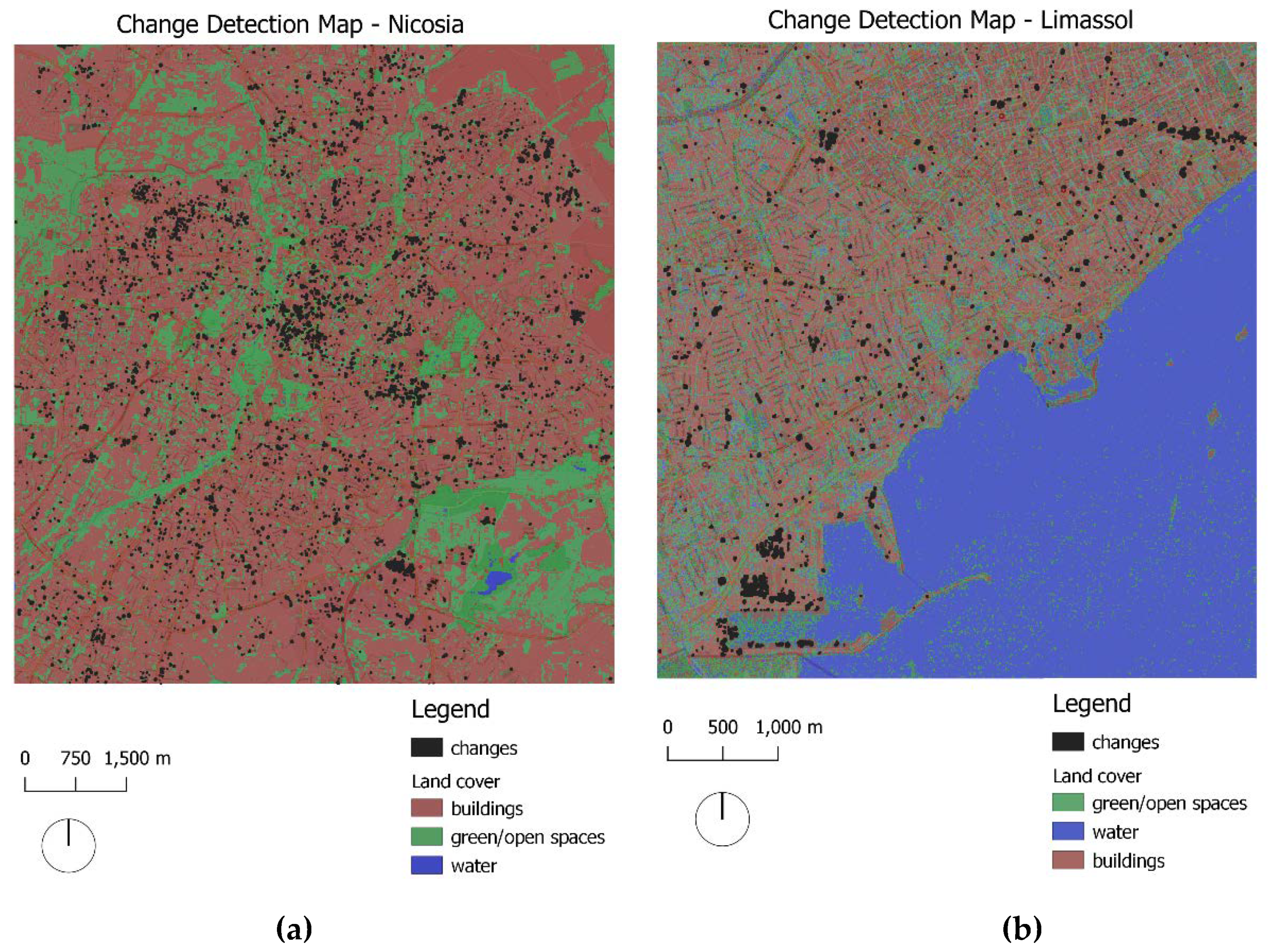
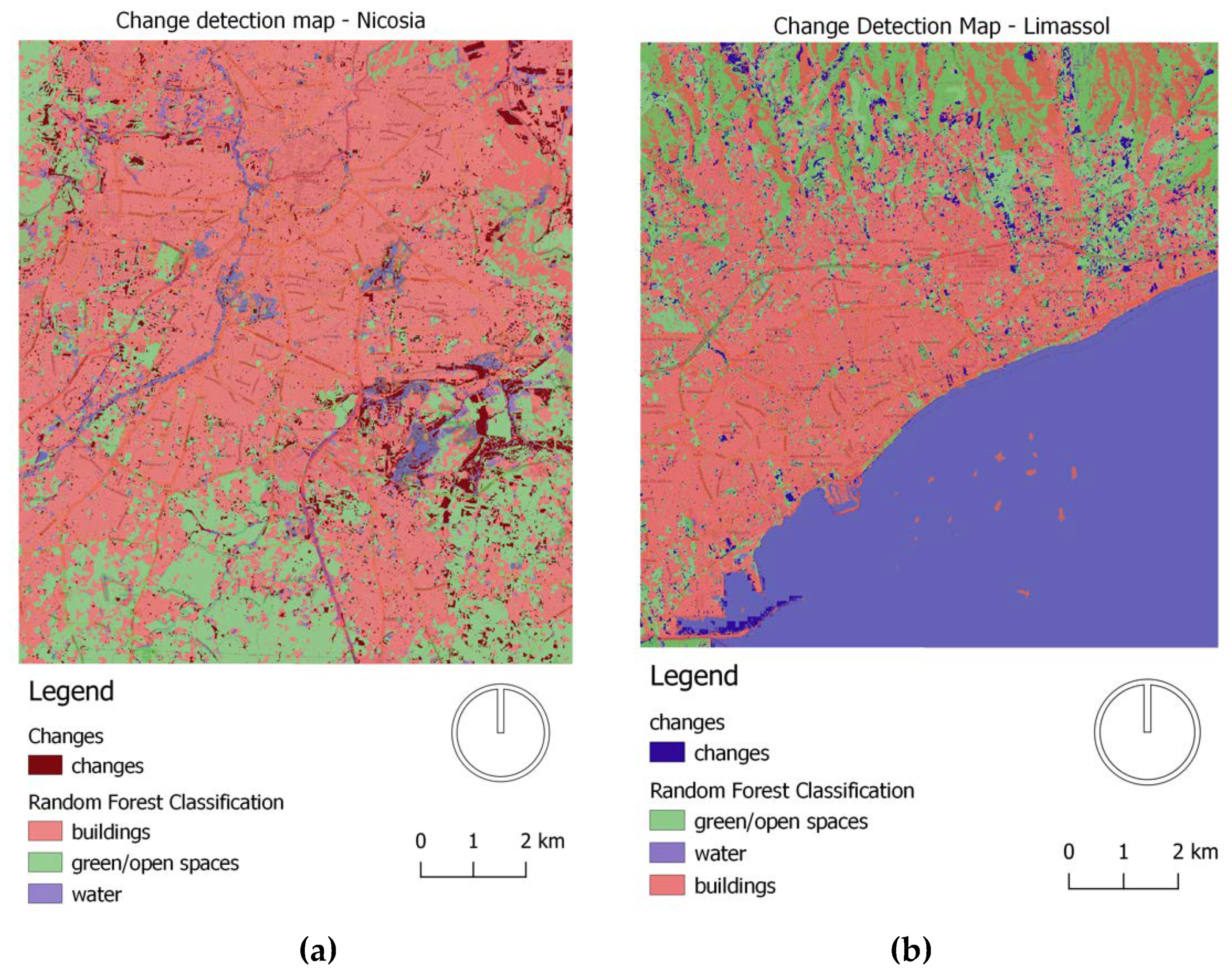
Figure 11.
Change detection maps produced by optical data wherein polygons of changes are overlaid with the classification results: (a) Nicosia; (b) Limassol.
Figure 11.
Change detection maps produced by optical data wherein polygons of changes are overlaid with the classification results: (a) Nicosia; (b) Limassol.
In the context of PERIScOPE, the historic cluster of Strovolos in Nicosia and the Turkish-Cypriot quarter of Limassol were selected as the testbed areas for further and focused analysis. Figure 23(a) displays a map that visualizes changes in the Strovolos area and the land cover layer. The identified changes in Strovolos' surrounding environment can be interpreted from the expansion and transformation of the region during the past few years. In addition to the residential uses, the area was recently transfored into a semi-commercial center.
In the Limassol neighborhoods, the classification analysis was conducted again with the joint use of radar and optical data in order to detect in detail the borders between the Limassol marina and the sea. 93% overall accuracy was achieved. In that case, the change detection was performed in SAR data, implementing the SNAP change detection tool. Fewer changes were tracked that were interpreted as typical built environment changes by new building construction and the creation of the marina of Limassol, cf. Figure 12(b).
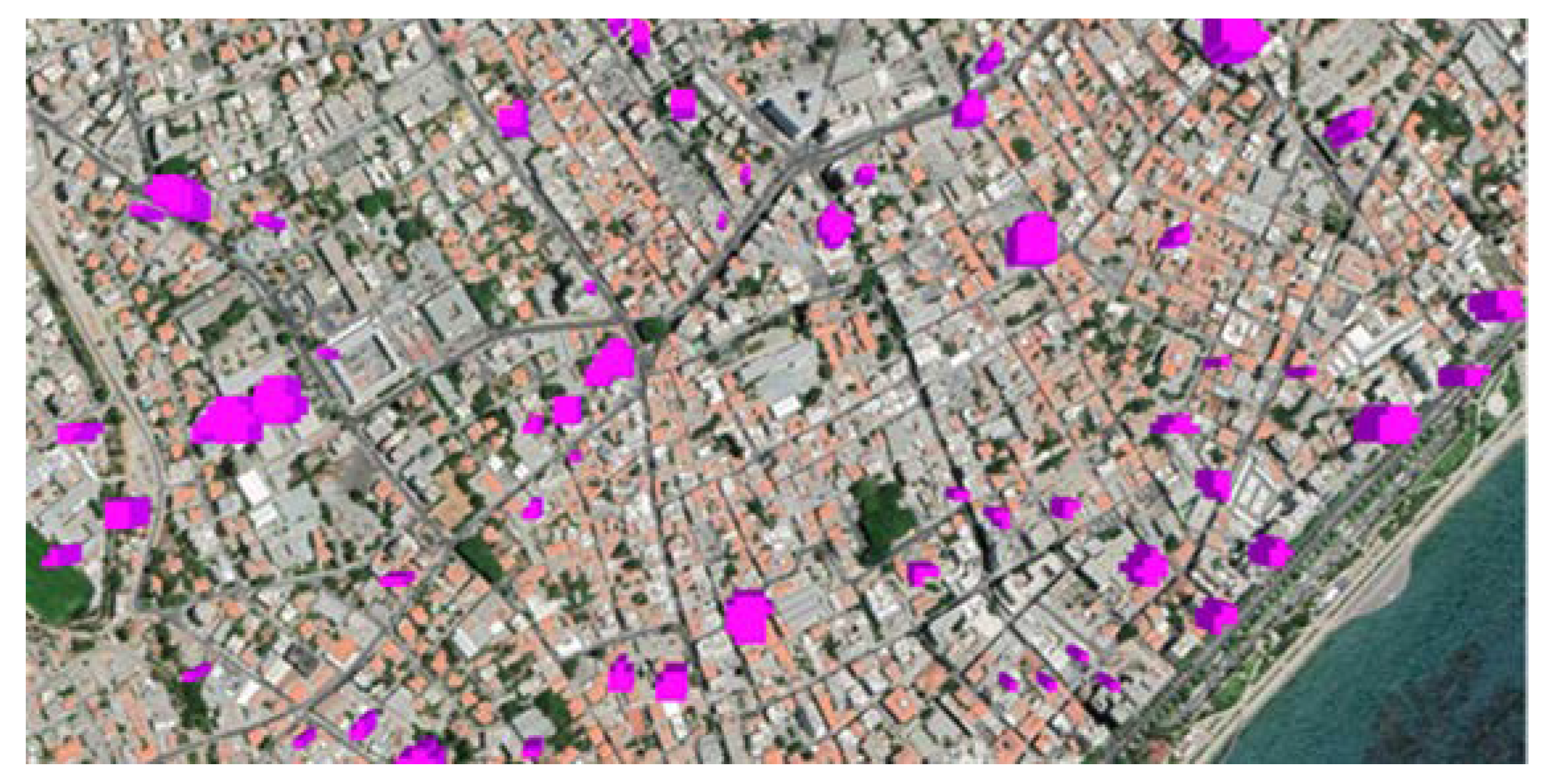
As the final results of this study are expected to be integrated in the PERIsCOPE platform, it was required to convert the research outputs into two-dimensional georeferenced data, as well as to generate their three-dimensional representations. The 3D maps provide a realistic representation of the tracked changes that professionals and the stakeholders of the city may use. Figure 13 displays a screenshot of the change detection 3D map of Limassol.
Figure 12.
Focused analysis of the study areas by means of change detection maps of: (a) Strovolos; (b) Turkish-Cypriot quarter of Limassol.
Figure 12.
Focused analysis of the study areas by means of change detection maps of: (a) Strovolos; (b) Turkish-Cypriot quarter of Limassol.
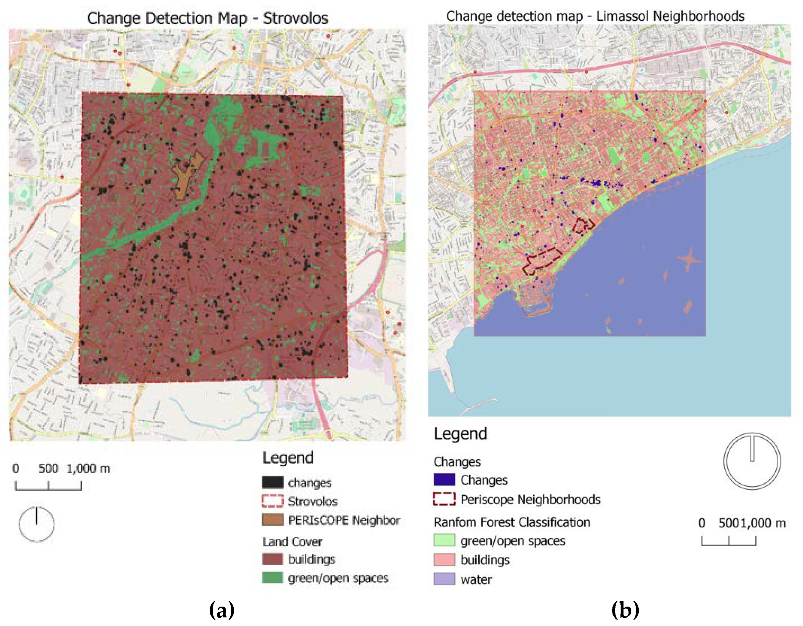
Figure 13.
3D change detection map of Limassol.
8. Discussion
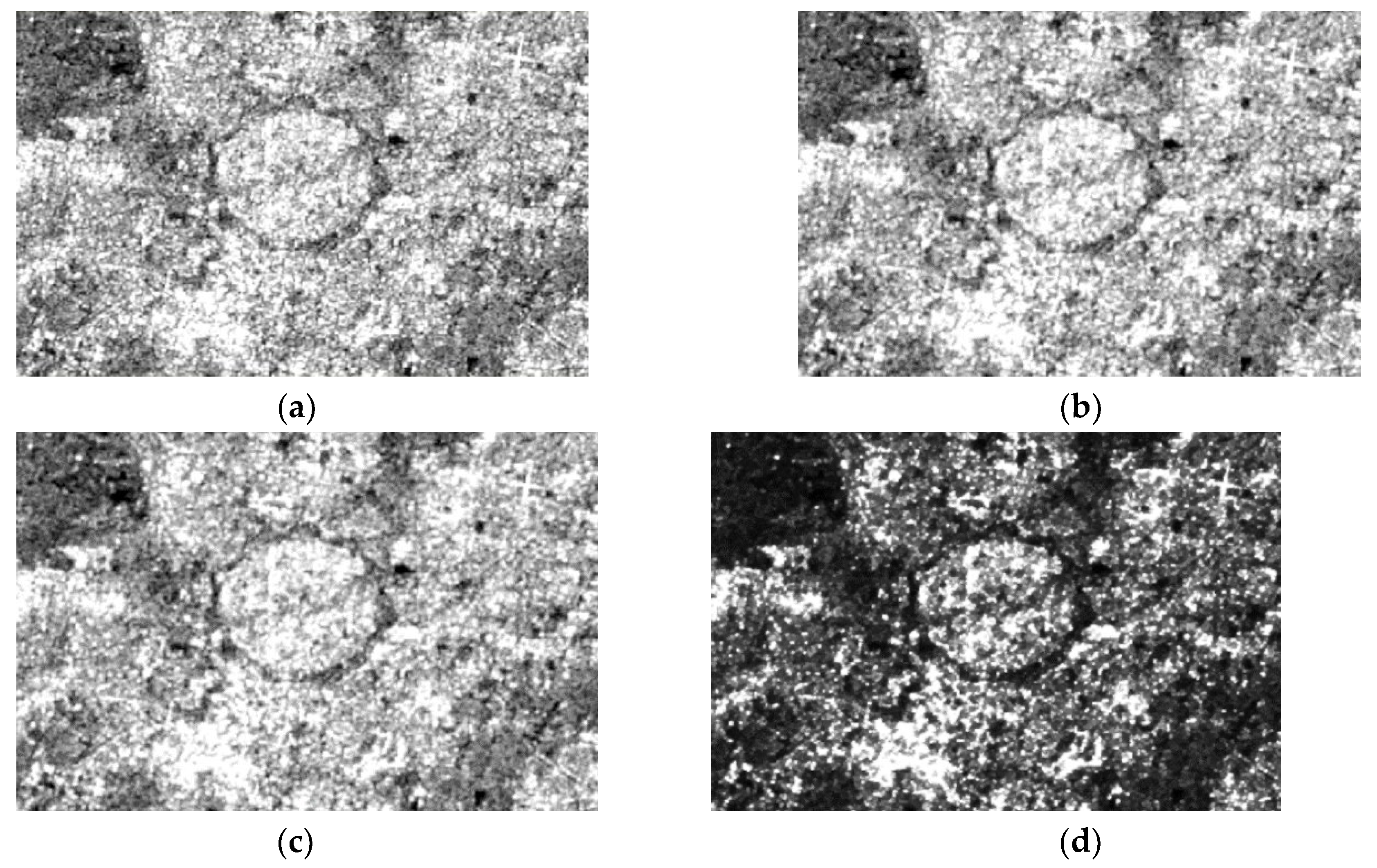
In this study, the classification results were derived from supervised machine learning algorithms, such as the random forest and the maximum likelihood classifier. This kind of approach demands labeled data to predict outcomes. However, obtaining an adequate amount of data might be a challenge for researchers. For instance, in this study, the supervised algorithms could not be utilized on 2016 images due to the limited availability of OpenStreetMap land cover data from that year. In this case, unsupervised machine learning algorithms could be applied. The study presented how unsupervised learning can identify hidden patterns or intrinsic structures in the data, and it can be used to draw conclusions from datasets composed of unlabelled input data. Specifically, in this step of the research process, the k-means algorithm was applied, which assigns each data point to the cluster whose center is closer [29]. The k-means classifier was selected as it is one of the most widely used unsupervised algorithms. Figure 25 displays the result of k-means classification in Nicosia, as applied in both Sentinel-1 and Sentinel-2 images. 30 iterations and 3 clusters were chosen as the parameters of the algorithm. As can be noticed, the outputs of the k-means analysis are imprecise. For instance, in the radar image, the water bodies of Nicosia were not detected, and in the optical image, the water class covers 22.286% of the region of interest, which is not valid. The study showed that supervised random forest and maximum likelihood classification can be much more accurate than unsupervised k-means classification, but unsupervised classification is particularly useful when data or prior knowledge about the study area is not available.
Figure 14.
K-means unsupervised classification results in Nicosia as applied in: (a) Sentinel-1; (b) Sentinel-2.
Figure 14.
K-means unsupervised classification results in Nicosia as applied in: (a) Sentinel-1; (b) Sentinel-2.
9. Conclusions
The aim of this study was to present a methodology for change detection in urban environments, with the emjployment of supervised machine learning algorithms. Additionally, the performance of the synergetic use of radar and optical data was examined. Specifically, the Sentinel-1 SAR images were combined with Sentinel-2 images, indicating that a significant improvement in land cover classification accuracy can be achieved, compared to the case where only optical or radar imagery is used. The temporal analysis was conducted for the time period 2016-2019 for the two Cypriot cities, Nicosia and Limassol, and the required Sentinel-1 and Sentinel-2 images were acquired by the European Space Agency's (ESA) Copernicus Hub. The entire processing workflow was completed on the SNAP environment, a tool used for Earth Observation analysis. The study's results deliver information concerning the cities' expansion trend and map the urban landscape changes and dynamics.
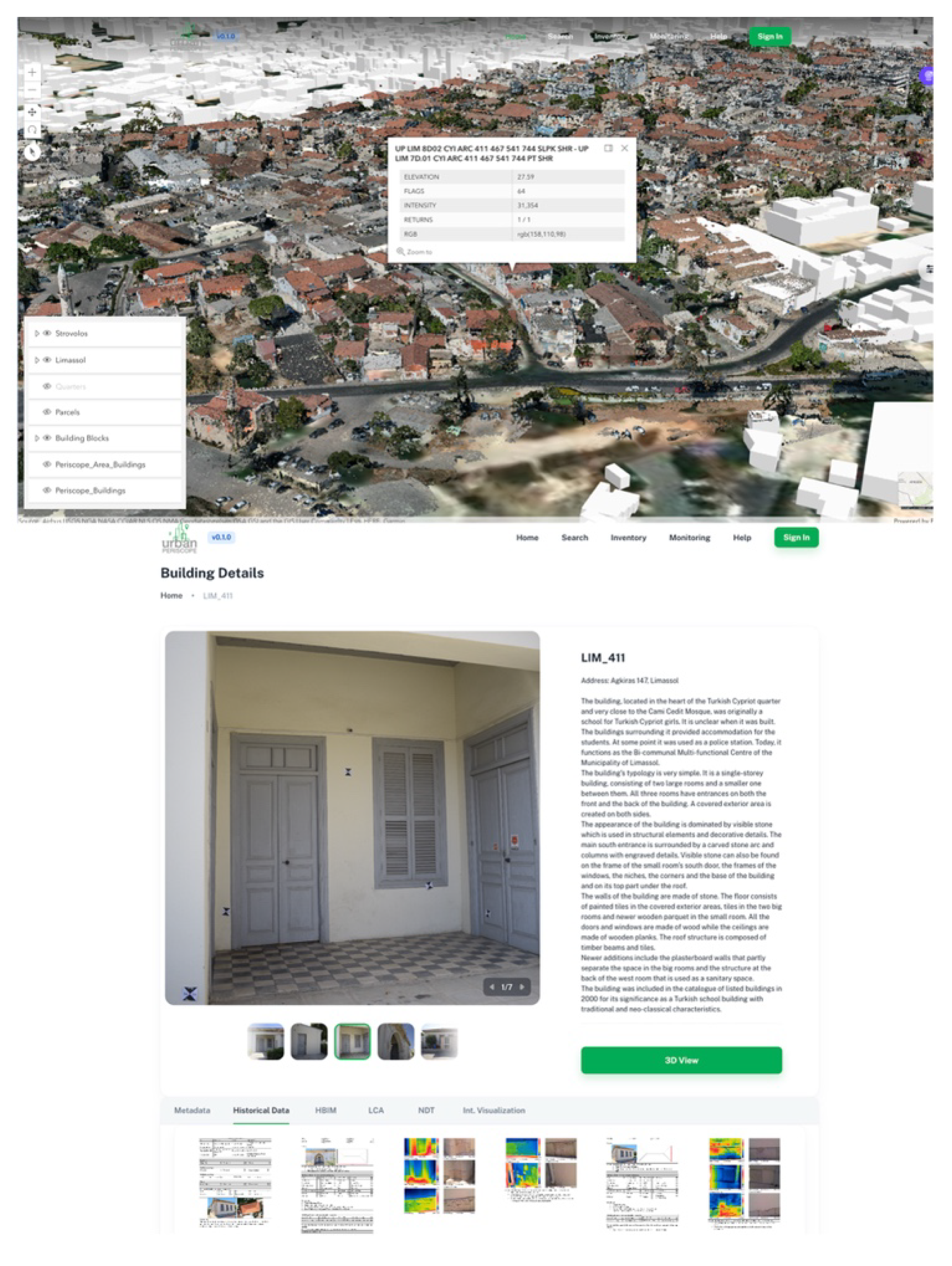
The main contribution of this study concerns the evaluation of a workflow that can be used in the built environment of historic clusters in Cypriot cities, with the purpose to enable authorities to monitor the urban fabric of sensitive areas,threatened by climate, decay, through the PERIsCOPE platform. The following development steps of the presented research comprise the integration of the QGIS datasets delivered by this process into the PERIsCOPE platform (Figure 12). More specifically, the results will be available in GeoTIFF format, downloadable and also visualized in interactive maps. The future research in this topic includes the integration of the presented methodology as a tool into the content management system that supports the PERIsCOPE platform. This tool in the future will facilitate the identification of multi-temporal changes in the vicinity of heritage buildings clusters based on satellite images, in an online, user-friendly environment. Combined with maps of land surface temperatures [30] of the areas under study, the authors envision that this tool will become a valuable support mechanism for data interpretation and decision making in heritage management and building conservation processes.
Figure 12.
Data visualization of Strovolos historical core on the alpha version of the online PERIsCOPE platform.
Figure 12.
Data visualization of Strovolos historical core on the alpha version of the online PERIsCOPE platform.
This study has also a major contribution in the field of the sustainable and energy efficient heritage-built environment, as it provides the ground for analysis related to the urban heat island effect. The development and delivery of tools, which allow the comprehensive investigation of the change in the urban density and spatial planning, establishes the conditions for detailed insights in parameters which affect the city microclimate. The PERIsCOPE HBIM platform value added service, presented in this study delivers new perspectives for HBIM tools, enabling the combination of information in different layers towards a more energy efficient built environment.
While the presented workflow and methods are applied as a pilot in the analysis of vulnerable historic clusters in Cypriot cities that are facing rapid urbanization challenges as well as the impact of climate change, the research can be applicable to other historical city regions, using the technical guidelines, workflows, and instructions delivered under the context of this study. The potential of promoting heritage re-use and safeguarding as a pillar of socio-economic growth and sustainable development is gaining acknowledged by policy- and decision makers. This study addresses the need for agile digitization and open access comprehensive information resources for building energy upgrade.
Supplementary Materials
The following supporting information can be downloaded at: https://youtu.be/lFMau9XZrKs [alpha version of the UPERIsCOPE platform]; https://youtu.be/tFZ_aDuhWw8 [data fusion].
Author Contributions
Conceptualization, Georgios Artopoulos and Maria Spyridoula Tzima; methodology, Athos Agapiou, Charalambos Chrysostomou and Paris Fokaides; software; validation; formal analysis; investigation; resources; data curation, Maria Spyridoula Tzima, Athos Agapiou and Charalambos Chrysostomou; writing—original draft preparation, Maria Spyridoula Tzima and Georgios Artopoulos; writing—review and editing, Athos Agapiou, Charalambos Chrysostomou, Vasiliki Lysandrou and Paris Fokaides; visualization, Maria Spyridoula Tzima; supervision, Georgios Artopoulos; project administration, funding acquisition, Georgios Artopoulos. All authors have read and agreed to the published version of the manuscript.
Funding
“Portal for heritage buildings integration into the contemporary built environment” (URBAN PERIsCOPE), is funded by the Cyprus Research & Innovation Foundation Restart Programs 2016-2020 “Integrated Projects”. Project Coordinator: The Cyprus Institute; Partners: Cyprus University of Technology (Cyprus), Frederic Research Center (Cyprus), Fondazione Bruno Kessler (Italy), University of Catania (Italy), Department of Urban Planning and Housing, Municipality of Strovolos, Municipality of Limassol, HIT- Hypertech Innovations, NetU Consultations and Talos RTD. The project PERIsCOPE INTEGRATED/0918/0034 is co-financed by the European Regional Development Fund and the Republic of Cyprus through the Research Innovation Foundation.
Data Availability Statement
Sample datasets of satellite analysis and of one pilot building that support the findings of this study are openly available in Zenodo at https://doi.org/10.5281/zenodo.7426346; https://doi.org/10.5281/zenodo.7404274, respectively. Further datasets that support the findings of this study are openly available in UPERIsCOPE platform at https://uperiscope.hpcf.cyi.ac.cy/.
Conflicts of Interest
“The authors declare no conflict of interest.”.
References
- Boulanger, S.O.M. The Roadmap to Smart Cities: A Bibliometric Literature Review on Smart Cities’ Trends before and after the COVID-19 Pandemic. Energies 2022, 15, 9326. [Google Scholar] [CrossRef]
- Yarashynskaya, A.; Prus, P. Smart Energy for a Smart City: A Review of Polish Urban Development Plans. Energies 2022, 15, 8676. [Google Scholar] [CrossRef]
- Adibhesami, M.A.; Karimi, H.; Sharifi, A.; Sepehri, B.; Bazazzadeh, H.; Berardi, U. Optimization of Urban-Scale Sustainable Energy Strategies to Improve Citizens’ Health. Energies 2023, 16, 119. [Google Scholar] [CrossRef]
- Rong, T.; Zhang, P.; Jing, W.; Zhang, Y.; Li, Y.; Yang, D.; Yang, J.; Chang, H.; Ge, L. Carbon Dioxide Emissions and Their Driving Forces of Land Use Change Based on Economic Contributive Coefficient (ECC) and Ecological Support Coefficient (ESC) in the Lower Yellow River Region (1995–2018). Energies 2020, 13, 2600. [Google Scholar] [CrossRef]
- Jadraque Gago, E.; Etxebarria Berrizbeitia, S.; Pacheco Torres, R.; Muneer, T. Effect of Land Use/Cover Changes on Urban Cool Island Phenomenon in Seville, Spain. Energies 2020, 13, 3040. [Google Scholar] [CrossRef]
- Chen, Y.; Weng, Q.; Tang, L.; Liu, Q.; Zhang, X.; Bilal, M. Automatic mapping of urban green spaces using a geospatial neural network. GISci. Remote Sens. 2021, 58, 624–642. [Google Scholar] [CrossRef]
- Verde, N.; Patias, P.; Mallinis, G. A Cloud-Based Mapping Approach Using Deep Learning and Very-High Spatial Resolution Earth Observation Data to Facilitate the SDG 11.7.1 Indicator Computation. Remote Sens. 2022, 14, 1011. [Google Scholar] [CrossRef]
- Liu, H.; Yang, M.; Chen, J.; Hou, J.; Deng, M. Line-constrained shape feature for building change detection in VHR remote sensing imagery. ISPRS Int. J. Geo-Inf. 2018, 7, 410. [Google Scholar] [CrossRef]
- Luo, L.; Li, P.; Yan, X. Deep Learning-Based Building Extraction from Remote Sensing Images: A Comprehensive Review. Energies 2021, 14, 7982. [Google Scholar] [CrossRef]
- Li, L.; Wang, C.; Zhang, H.; Zhang, B.; Wu, F. Urban building change detection in SAR images using combined differential image and residual u-net network. Remote Sens. 2019, 11, 1091. [Google Scholar] [CrossRef]
- Papadomanolaki, M.; Verma, M.S.; Vakalopoulou, S.G.; Karantzalos, K. “Detecting Urban Changeswith Recurrent Neural Networks from Multitemporal Sentinel-2 Data”. In Proceedings of the International Geoscience and Remote Sensing Symposium (IGARSS); 2019; pp. 214–217. [Google Scholar]
- SNAP—ESA Sentinel Application Platform v9.0.0. Available online: https://step.esa.int (accessed on 2 February 2023).
- Radutu, A.; Sandru, M.I.V.; Nedelcu, I.; Poenaru, V.D. Change Detection trends in urban areas with remote sensing and socio-economic diagnosis in Bucharest city. In Proceedings of the International Multidisciplinary Scientific GeoConference: SGEM, Sofia, Bulgaria; 2021; Volume 21. [Google Scholar]
- Sundaram, S.; Yarrakula, K. Multi-temporal analysis ofSentinel-1 SAR data for urban flood inundation mapping—Casestudy of Chennai Metropolitan City. Indian J. Ecol. 2017, 44, 564–568. [Google Scholar]
- Simeone, D.; Rotilio, M.; Cucchiella, F. Construction Work and Utilities in Historic Centers: Strategies for a Transition towards Fuel-Free Construction Sites. Energies 2023, 16, 700. [Google Scholar] [CrossRef]
- Chahardowli, M.; Sajadzadeh, H.; Aram, F.; Mosavi, A. Survey of Sustainable Regeneration of Historic and Cultural Cores of Cities. Energies 2020, 13, 2708. [Google Scholar] [CrossRef]
- Agapiou, A. Estimating Proportion of Vegetation Cover at the Vicinity of Archaeological Sites Using Sentinel-1 and -2 Data, Supplemented by Crowdsourced OpenStreetMap Geodata. Appl. Sci. 2020, 10, 4764. [Google Scholar] [CrossRef]
- OpenStreetMap Service. Available online: https://www.openstreetmap.org/ (accessed on 2 February 2023).
- Faizan, M. Radarsat-2 Data Processing Using SNAP Software (2020). Available online: https://www.researchgate.net/publication/352934165_Radarsat-2_data_processing_using_SNAP_software (accessed on 2 February 2023).
- Jiang, W.; Yu, A.; Dong, Z.; Wang, Q. Comparison and analysis of geometric correction. Sensors 2016, 16, 973. [Google Scholar] [CrossRef] [PubMed]
- Santoso, A.W.; Bayuaji, L.; Sze, L.T.; Lateh, H.; Zain, J.M. Comparison of various speckle noise reduction filters on synthetic aperture radar image. Int. J. Appl. Eng. Res. 2016, 11, 8760–8767. [Google Scholar]
- Raiyani, K.; Gonçalves, T.; Rato, L.; Salgueiro, P.; Marques da Silva, J.R. Sentinel-2 Image Scene Classification: A Comparison between Sen2Cor and a Machine Learning Approach. Remote Sens. 2021, 13, 300. [Google Scholar] [CrossRef]
- Richards, J.A. Remote Sensing Digital Image Analysis: An Introduction; Springer: Berlin/Heidelberg, Germany, 1999; 240p. [Google Scholar]
- Breiman, L. Random Forests. Mach. Learn. 2001, 45, 5–32. [Google Scholar] [CrossRef]
- QGIS Development Team. QGIS Geographic Information System. Open Source Geospatial Foundation Project. Available online: http://qgis.osgeo.org (accessed on 2 February 2023).
- Singh, A. Change detection in the tropical forest environment of north eastern India using Landsat. In Remote Sensing and Tropical Land Management; Eden, M.J., Parry, J.T., Eds.; Wiley: Hoboken, NJ, USA, 1986; pp. 237–254. [Google Scholar]
- Lu, D.; Mausel, P.; Brondizio, E.; Moran, E. Change detection techniques. Int. J. Remote Sens. 2004, 25, 2365–2401. [Google Scholar] [CrossRef]
- Close, O.; Petit, S.; Beaumont, B.; Hallot, E. Evaluating 1. The Potentiality of Sentinel-2 for Change Detection Analysis Associated to LULUCF in Wallonia, Belgium. Land 2021, 10, 55. [Google Scholar] [CrossRef]
- Krishna, K.; Narasimha Murty, M. Genetic K-means algorithm. IEEE Trans Syst Man Cybern B Cybern. 1999, 29, 433–439. [Google Scholar] [CrossRef] [PubMed]
- Agapiou, A.; Lysandrou, V.; Hadjimitsis, D. Analysing the thermal conditions of historic buildings in Cyprus using archive Landsat satellite data and Google Earth Engine big data cloud platform, ΙΜΕΚO. In Proceedings of the International Conference on Metrology for Archaeology and Cultural Heritage, Virtual, 22–24 October 2020. [Google Scholar]
Disclaimer/Publisher’s Note: The statements, opinions and data contained in all publications are solely those of the individual author(s) and contributor(s) and not of MDPI and/or the editor(s). MDPI and/or the editor(s) disclaim responsibility for any injury to people or property resulting from any ideas, methods, instructions or products referred to in the content. |
© 2023 by the authors. Licensee MDPI, Basel, Switzerland. This article is an open access article distributed under the terms and conditions of the Creative Commons Attribution (CC BY) license (http://creativecommons.org/licenses/by/4.0/).
Copyright: This open access article is published under a Creative Commons CC BY 4.0 license, which permit the free download, distribution, and reuse, provided that the author and preprint are cited in any reuse.


