
Submitted:
13 November 2022
Posted:
17 November 2022
You are already at the latest version
Abstract
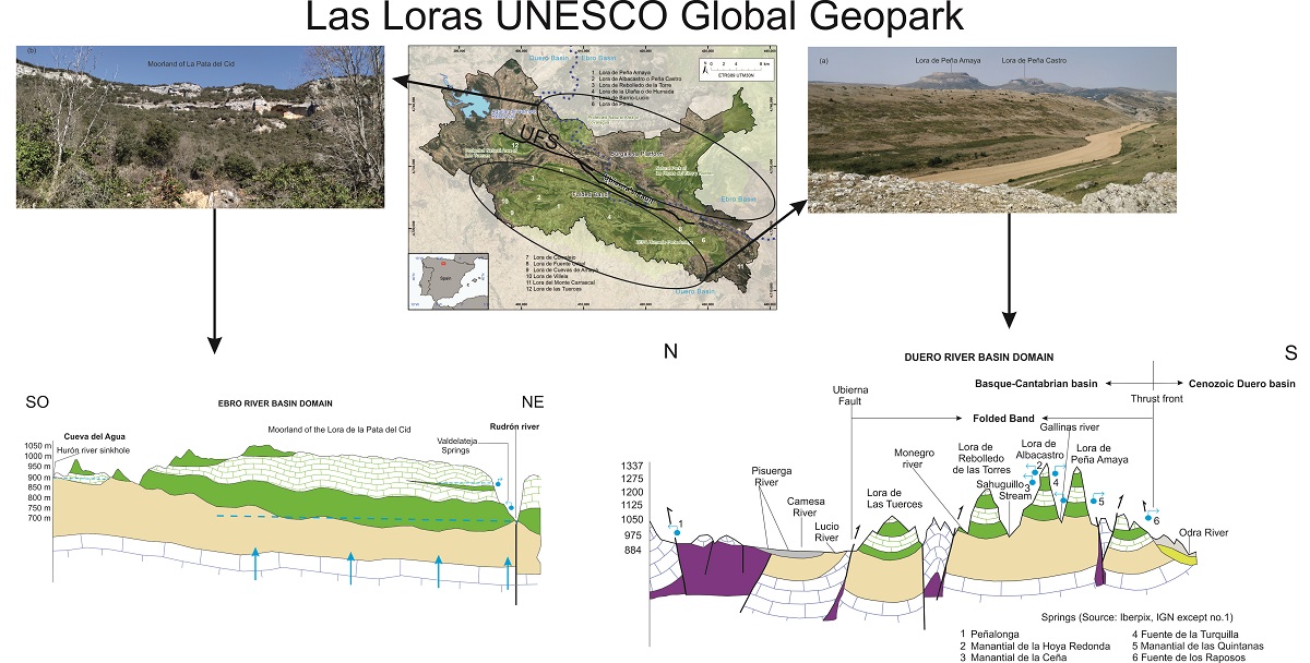
Las Loras UNESCO Global Geopark (UGGp) is geologically diverse, particularly in relation to water-derived features: springs, karst springs, travertine buildings, waterfalls, caves. In this work, the interactions between geology, geomorphology, structures and hydrogeology are analyzed. These four components are the fundamentals of geodiversity and their interactions provide a conceptual model of hydrogeological functioning at Las Loras UGGp. The most plausible hypothesis is that the system is formed by two superimposed aquifer systems, separated by an aquitard formed by Lower Cretaceous material. The deep lower aquifer formed by the Jurassic limestones only outcrops on the northern and southern edges of the Geopark and in a small arched band to the south of Aguilar de Campoo. It forms a basement subject to intense deformation. The upper aquifer system, formed by outcropping materials from the Upper Cretaceous, is a free aquifer. It is formed by a multilayered aquifer system that is highly compartmentalized by the very disturbed geomorphology of the landscape, constituting each moorland and each lora, an individualized recharge-discharge system. This model explains the base level of the rivers, the abundant number of existing springs and the permanent nature of some rivers, providing the keys to understand the bases of the geoconservation of a rich geological heritage linked to the active processes of the water cycle.
Keywords:
Geodiversity
; geosites
; springs
; Las Loras UNESCO Global Geopark (UGGp)
; hydrogeology
; Ubierna Fault
Copyright: This open access article is published under a Creative Commons CC BY 4.0 license, which permit the free download, distribution, and reuse, provided that the author and preprint are cited in any reuse.


