PreprintCommunicationVersion 1Preserved in Portico This version is not peer-reviewed
Comparing High-Resolution Satellite and GatorEye UAV Lidar Data for Trail Mapping in Mixed Pine and Oak Forests in Central Florida Using a Participatory Approach
Version 1
: Received: 26 December 2020 / Approved: 28 December 2020 / Online: 28 December 2020 (12:32:22 CET)
How to cite:
Báez, M.C.; Almeyda Zambrano, A.M.; Gutierrez, B.L.; Stokes, G.; Chavez, J.; Montero-Alvarez, P.; Fiorini, A.O.; Olaechea, D.G.; Wilkinson, B.; Broadbent, E.N. Comparing High-Resolution Satellite and GatorEye UAV Lidar Data for Trail Mapping in Mixed Pine and Oak Forests in Central Florida Using a Participatory Approach. Preprints2020, 2020120699. https://doi.org/10.20944/preprints202012.0699.v1
Báez, M.C.; Almeyda Zambrano, A.M.; Gutierrez, B.L.; Stokes, G.; Chavez, J.; Montero-Alvarez, P.; Fiorini, A.O.; Olaechea, D.G.; Wilkinson, B.; Broadbent, E.N. Comparing High-Resolution Satellite and GatorEye UAV Lidar Data for Trail Mapping in Mixed Pine and Oak Forests in Central Florida Using a Participatory Approach. Preprints 2020, 2020120699. https://doi.org/10.20944/preprints202012.0699.v1
Báez, M.C.; Almeyda Zambrano, A.M.; Gutierrez, B.L.; Stokes, G.; Chavez, J.; Montero-Alvarez, P.; Fiorini, A.O.; Olaechea, D.G.; Wilkinson, B.; Broadbent, E.N. Comparing High-Resolution Satellite and GatorEye UAV Lidar Data for Trail Mapping in Mixed Pine and Oak Forests in Central Florida Using a Participatory Approach. Preprints2020, 2020120699. https://doi.org/10.20944/preprints202012.0699.v1
APA Style
Báez, M.C., Almeyda Zambrano, A.M., Gutierrez, B.L., Stokes, G., Chavez, J., Montero-Alvarez, P., Fiorini, A.O., Olaechea, D.G., Wilkinson, B., & Broadbent, E.N. (2020). Comparing High-Resolution Satellite and GatorEye UAV Lidar Data for Trail Mapping in Mixed Pine and Oak Forests in Central Florida Using a Participatory Approach. Preprints. https://doi.org/10.20944/preprints202012.0699.v1
Chicago/Turabian Style
Báez, M.C., Ben Wilkinson and Eben North Broadbent. 2020 "Comparing High-Resolution Satellite and GatorEye UAV Lidar Data for Trail Mapping in Mixed Pine and Oak Forests in Central Florida Using a Participatory Approach" Preprints. https://doi.org/10.20944/preprints202012.0699.v1
Abstract
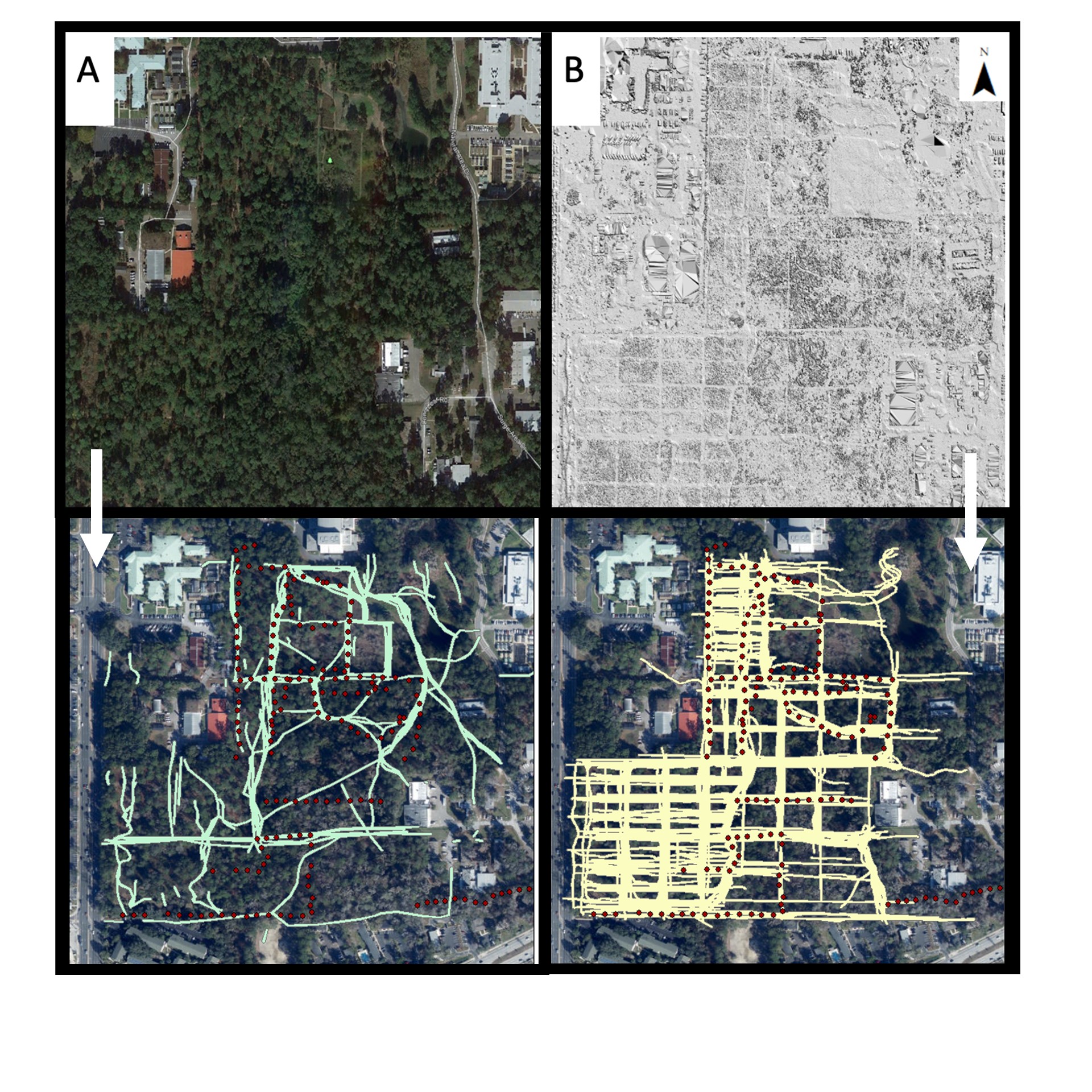
Trail detection in mixed canopy ecosystems has important implications for forest management, monitoring, and conservation, although active sensor technology for sub-canopy trail detection is still developing. In order to assess the effectiveness of UAV(Unmanned Aerial Vehicle)-borne lidar (light detection and ranging) data for small trails (< 2.5m width) in mixed forest canopy cover, we collected lidar data and trail characteristics (canopy cover and trail width) and created a high definition surface model map from the resulting lidar data, and also a high-resolution satellite imagery map using Google Earth. Through participatory mapping methods, seven respondents with limited prior geospatial experience completed a rapid identification of trails on both maps. Respondents’ trails were georeferenced in order to compare the rate of detectability between maps. We found greater detection on the lidar-derived map compared to the Google Earth map. Detectability in Google Earth maps was positively correlated with wider trails and trials with lower canopy. In lidar maps, trail detectability increased with wider trails, but canopy cover had no effect on detection rates. Our data indicate that a mixed-method approach that combines UAV-mounted lidar with high-resolution satellite imagery and participatory mapping increases rapid detection rates of small trails under varying canopy cover and trail widths.
Copyright:
This is an open access article distributed under the Creative Commons Attribution License which permits unrestricted use, distribution, and reproduction in any medium, provided the original work is properly cited.