
Submitted:
29 December 2019
Posted:
30 December 2019
You are already at the latest version
Abstract
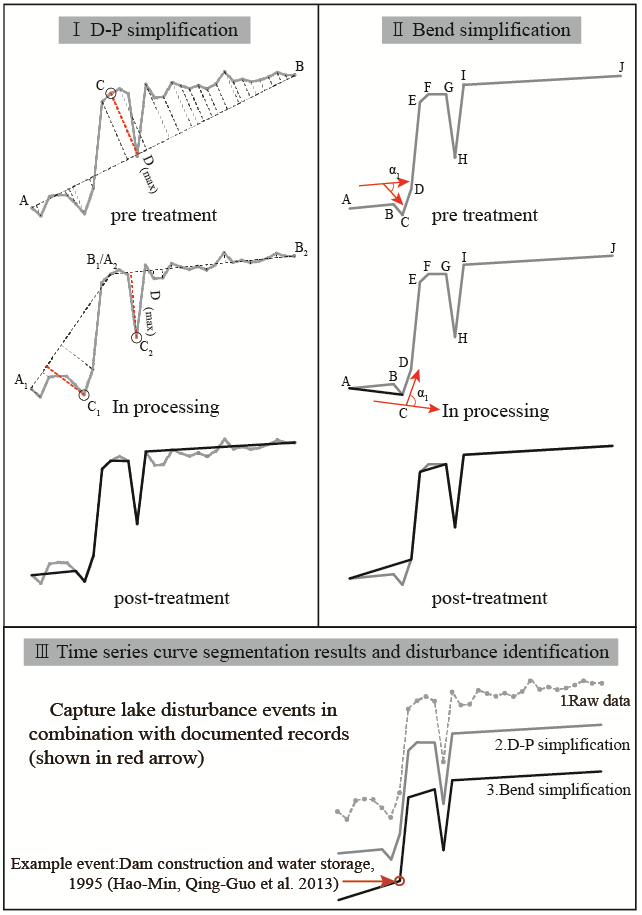
Inland lake variations are considered sensitive indicators of global climate change. However, human activity is playing as a more and more important role in inland lake area variations. Therefore, it is critical to identify whether anthropogenic activity or natural event is playing as the dominant factor in inland lake surface area change. In this study, we proposed a Douglas-Peucker simplification algorithm and bend simplification algorithm combined method to locate major lake surface area disturbances; these disturbances were then characterized to extract the time series change features according to documented records; and the disturbances were finally classified into anthropogenic or natural. We took the nine lakes in Yunnan Province as test sites, a 31 years long (from 1987 to 2017) time series Landsat TM/OLI images and HJ-1A/1B used as data sources, the official records was used as references to aid the feature extraction and disturbance identification accuracy. Results of our method for both disturbance location and the disturbance identification could be concluded as follows: 1) The method can accurately locate the main lake changing events based on the time series lake surface area curve. The accuracy of this model for segmenting the lake area time series curves in our study area was 95.24%. 2) Our proposed method achieved an overall accuracy of 91.67%, with F-score of 94.67 for anthropogenic disturbances and F-score of 85.71 for natural disturbances. 3) According to our results, lakes in Yunnan Provence, China, have undergone extensive disturbances, and the human-induced disturbances occurred almost twice as often as natural disturbances, indicating intensified disturbances caused by human activities. This inland lake area disturbance identification method is expected to uncover whether a disturbance to inland lake area is human activity-induced or natural event.
Keywords:
time series
; lake changes
; remote sensing
; inland lake
; lake disturbance
Copyright: This open access article is published under a Creative Commons CC BY 4.0 license, which permit the free download, distribution, and reuse, provided that the author and preprint are cited in any reuse.


